Urban Encounters: Imaging the City in Mandate Palestine - Brill
←
→
Page content transcription
If your browser does not render page correctly, please read the page content below
Chapter 11

Urban Encounters: Imaging the City
in Mandate Palestine

           Nadi Abusaada

In the first half of the twentieth century, Palestine witnessed significant trans-
formations in its urban built environment. These changes, while originating
in the late Ottoman era, intensified under the British Mandate with the intro-
duction of new inter-urban infrastructures and regional and urban planning
policies that controlled urban expansion and the construction of new urban
and rural settlements.1 The new urban planning development procedures,
however, were not merely a technical exercise – they supplemented British
imperial aspirations and their endorsement of Jewish settlement in Palestine.
In the interwar period, urban affairs turned into a primary field of political
confrontation and contestation between the local Arab population, Zionist
settlers and the British administration.
   This period of urban change in Palestine paralleled the rise of photographic
production as a principal method for documenting and representing the
built environment. Until the late nineteenth century, the dominant depic-
tions of Palestine’s urban and rural landscapes were the works of Orientalists
and Biblical scholars interested in excavating and documenting sites of holy
relevance for European audiences. By the start of the Mandate period, pho-
tography had already become a common practice by foreign groups and locals
alike. Arabs, Zionists, the British administration, and other interest groups (e.g.
foreign missionaries) all grew increasingly aware of the power of photographic
representations of the urban built environment, albeit utilising this power to
serve ideologically distinctive, even oppositional, visions and projects.2
   This chapter examines the historical intersection between photographic
practice and urban change in the colonial context of interwar Palestine. More
specifically, it aims to trace the different ways in which photographs were

1 J. Fruchtman, “Statutory Planning as a Form of Social Control: The Evolution of Town Planning
  Law in Mandatory Palestine and Israel 1917–1980’s” (PhD diss., University of London, 1986),
  http://discovery.ucl.ac.uk/1317972/.
2 See in this volume chapters by Karène Sanchez Summerer and Norig Neveu, Sary Zananiri,
  and Yazan Kopty.

© Nadi Abusaada, 2021 | doi:10.1163/9789004437944_012
This is an open access chapter distributed under the terms of the CC BY-NC-ND 4.0 license.
                                                                                       Nadi Abusaada - 9789004437944
                                                                       Downloaded from Brill.com10/20/2021 01:08:28AM
                                                                                                        via free access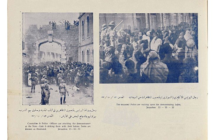
360                                                                                  Abusaada

utilised to represent the cities of Palestine, mainly from British and Arab
perspectives.3 With this in mind, the following sections will shed light on a
variety of photographic perspectives in representing Palestine’s urban built
environment in the interwar era. To highlight the links between these differ-
ent perspectives and the varying visions among and between British and Arab
actors in Palestine, however, the chapter focuses not on the original photo-
graphs or photographers themselves, but on the deliberate reproduction of
photographs and photographic collections by groups or individuals interested
in expressing a particular vision, colonial or otherwise, of the urban built
environment.
    To this end, the following sections will shed light on three interrelated
attitudes of photographic representation of Palestine’s urban fabrics in the
interwar period. First, the city as a target for military operations, focusing on the
advent of aerial photography in the Great War, its development in the Mandate
period, and its relationship to British imperial visions in Palestine. Second, the
utilisation of vues d’ensemble (‘holistic views’) of urban fabrics in the docu-
mentation and intervention in urban analysis and planning, through the use of
both aerial photographic and ground panoramas of urban spaces. Countering
these two attitudes, which were mainly a product of foreign and imperial activ-
ities, the third section addresses the rising interest among Palestine’s local
Arab population in the photographic imaging of their cities as a reflection of
their new societal ideals of progress, modernity and development, particularly
in Arabic-language press. These three distinctive yet interrelated attitudes
towards urban photography offer an understanding of photography not only as
an end in itself, but as a means to an end, linked to colonial and native desires
not only to represent but also reshape urban spaces.
    The materials in which these three different approaches to representing
the urban built environment appear have been collected from a wide range
of sources. The archival sources include the Bavarian State Archives, the
Australian War Museum, the National Library of Israel, and the Qatar Digital
Library. In addition, a collection of original publications including books,
reports and magazines from the 1920s–30s in English, Arabic and German
are also consulted and examined. Hence, if the focus in this article is mostly
on the immediate after-lives of photographs – that is, on the ways original

3 While it is realised that the Zionists, too, had a vested interest in the photographic rep-
  resentation of the urban built environment and urban development in Palestine during
  this period, a thorough analysis of Zionist imaging of the cities is beyond the scope of this
  study. Nonetheless, given that many aspects of British and Arab representations of cities in
  Palestine were ultimately shaped or influenced by their interactions with the Zionist move-
  ment, some elements of such encounters are addressed.

                                                                               Nadi Abusaada - 9789004437944
                                                                Downloaded from Brill.com10/20/2021 01:08:28AM
                                                                                                 via free access
Urban Encounters: Imaging the City in Mandate Palestine                                      361

photographs were re-produced in different formats within a few years of their
production – then the stories of how these different reproductions ended up
where they did adds additional layers and raise further questions regarding the
complex and multifaceted nature of these photographs’ afterlives.

1        Aerial Imagery and Military Strategy

In 1915, following Ottoman-German advancement into the British-controlled
Sinai Peninsula and their attempt to invade the Suez Canal, several battles were
fought in southern Palestine. As the war commenced, and as German-Ottoman
armies retreated, these battles shifted north until British armies gained full
control of Palestine. The visually abundant nature of these battles was unlike
anything the country had witnessed in its long history of foreign invasions.
This was not only because of the nature of the Great War as an event covered
by media outlets globally, but also in the then-new advancements in photogra-
phy and aerial warfare technology – producing the first ever aerial photographs
of landscapes. In the Great War, the ability to see cities from above became
intractably tied to gaining military advantage over enemy troops. In their con-
frontations, both German and British armies used airplanes to drop bombs on
enemy territory. They also utilised aeroplanes for aerial reconnaissance and
the production of war maps.
   By the time British troops reached northern Palestine, British-Australian
and Bavarian squadrons had captured several thousand aerial photographs
covering wide expanses of Palestine as well as Egypt, Lebanon, and Jordan
(Fig. 11.1). These photographs were used to detect the abilities of enemy
troops and predict their movements, and both the British and the Germans
devised military handbooks to assist in their analysis. Comparing British
and German handbooks on the tactical use of photographs from the war,
Benjamin Kedar points to the higher level of sophistication presented by the
Germans. Kedar notes that whereas the British booklets only present a ‘series of
rudimentarily interpreted photographs’, the German booklets include a ‘table
of the various types of British tents, the purposes they serve, their surface in
square meters, and the number of men they can accommodate’ in addition to
methodically grouped photographs that provide clues to the size of the enemy
in question.4

4 Benjamin Z. Kedar, The Changing Land: Between the Jordan and the Sea: Aerial Photographs
  from 1917 to the Present (Detroit: Wayne State University Press, 1999), 28.

                                                                            Nadi Abusaada - 9789004437944
                                                             Downloaded from Brill.com10/20/2021 01:08:28AM
                                                                                              via free access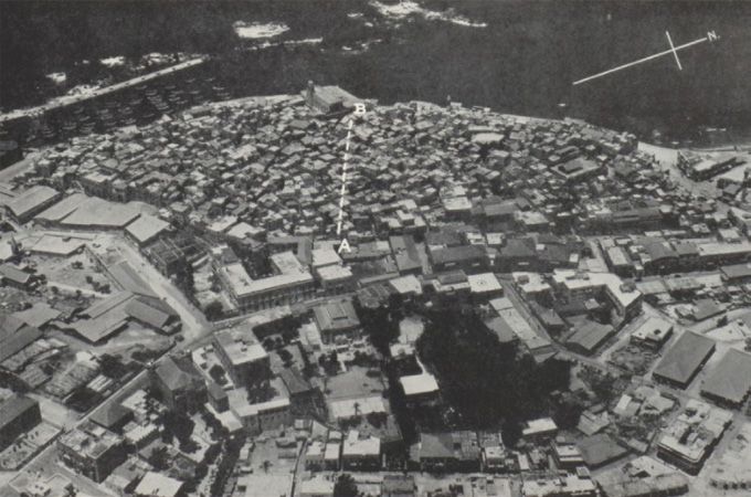
362                                                                                 Abusaada

    The culmination of these photographic advancements with the war effort
produced an entirely new understanding not only of warfare strategies but
also of landscapes. In the Bavarian and Australian aerial photographs alike,
the urban landscape below was abstracted into a series of quantifiable fea-
tures that marked the extent to which the territory depicted in the photograph
poses a threat. On many of the aerial photographs that survive in the Bavarian
State Archives and the Australian War Memorial, hand-drawn lines around tar-
geted areas appear, marking the locations of enemy targets. These targets were
often troop camps, located outside the towns, but in close proximity to them
to ensure their connection to the main transport infrastructures and access to
essential utilities (particularly water and health facilities). In most cases, the
defeat of these suburban camps entailed the capture of the towns that they
encircled. Overall, it can be said that although the cities’ surroundings were
clear military targets for the Germans and the British during the war, their
inner built fabrics remained, for the most part, relatively unharmed by the war
effort.
    While for the Germans, the Great War marked the end of their imperial
interests and aerial navigations in the ‘East’, this was far from being the case for
the British. After the war, the British devised new strategies of ‘air control’ over
its new mandated territories, based on their desire to safeguard their imperial
interests and contain attempts of rebellion. Among the earliest applications
of this new scheme of ‘air control’ by the British Royal Air Force (RAF) was
used in 1919 in Iraq in an effort to tame the Iraqi revolt against British colonial
rule. In this new scheme, Priya Satia explains, ‘the RAF collapsed the mission
of regenerating Babylonia into the more urgent task of patrolling the coun-
try from a network of bases and coordinating information from agents on the
ground to bombard subversive villages and tribes’.5 Although airpower was
also used elsewhere at the time, Satia shows that ‘it was in Iraq that the British
would rigorously practice, if never perfect, the technology of bombardment
as a permanent method of colonial administration and surveillance and there
that they would fully theorise the value of airpower as an independent arm of
the military’.6
    In Palestine, the most systematic use of airpower by the British took place
nearly two decades later, in the context of the Arab-led Great Revolt against
the British administration. The revolt, which was mainly directed against the
British administration, demanded Arab independence, an end to the British

5 Priya Satia, Spies in Arabia: The Great War and the Cultural Foundations of Britain’s Covert
  Empire in the Middle East (Oxford: Oxford University Press, 2008), 240.
6 Ibid., 240.

                                                                              Nadi Abusaada - 9789004437944
                                                               Downloaded from Brill.com10/20/2021 01:08:28AM
                                                                                                via free access
Urban Encounters: Imaging the City in Mandate Palestine                                         363

Figure 11.1     Map of Bavarian aerial photographs in Palestine during the Great War, 1916–18.
                Map by author
                Data sources: Bavarian State Archives, Google earth

endorsement of a ‘Jewish National Home’ in Palestine, and to cease its facilita-
tion of Zionist immigration and land settlement. As Jacob Norris illustrates, the
revolt initially manifested as an elitist and urban-led campaign of civil disobe-
dience and later developed into a far more violent and peasant-led resistance
movement.7 While the eventual decline of the revolt in 1939 has often been
attributed to internal weaknesses and divisions among the Arab population,
Norris aptly shows that British counterinsurgency played a considerable role
in the revolt’s demise.8 Nonetheless, unlike in 1919 Iraq, British counterinsur-
gency activity in 1936 Palestine took place in the context of an established civil
administration and policy and, as a result, had to balance between its civil and
military forces. Hence, while it departed from the ‘air control’ schemes devel-
oped in Iraq, it still utilised what the British termed a strategy of ‘combined

7 Jacob Norris, ‘Repression and Rebellion: Britain’s Response to the Arab Revolt in Palestine of
  1936–39’, The Journal of Imperial and Commonwealth History 36, no. 1 (2008): 25–45; Weldon
  Matthews, Confronting an Empire, Constructing a Nation: Arab Nationalists and Popular
  Politics in Mandate Palestine (London: I.B.Tauris, 2006).
8 Ibid., 27.

                                                                                Nadi Abusaada - 9789004437944
                                                                 Downloaded from Brill.com10/20/2021 01:08:28AM
                                                                                                  via free access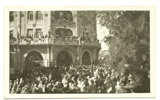
364                                                                                  Abusaada

action’ based on full cooperation between ground and air forces to overcome
the restrictions of British civil policy, particularly on the ‘employment of land
forces on offensive duties’.9
    In 1938, the British published a report titled ‘Military Lessons of the Arab
Rebellion in Palestine 1936’ which, as its title suggests, was based on their
various operations during the period of the revolt. The sections in the report
include a short history of the rebellion, conditions affecting operations,
commanders and staffs, intelligence, intercommunications, administration,
transport, weapons and equipment, the employment of the various arms, the
employment of aircraft, defensive action, protection of communications and
offensive action. The report also includes several photographs of the different
military operations, assessments, and documentation of the different vehi-
cles and equipment used in the duration of the revolt.10 But the most striking
among these are the series of aerial photographs of the Palestinian port city
of Jaffa, in which one of the most destructive operations during the revolt was
carried out: the demolition of a significant proportion of the Old City.
    Between 30th May and 30th June 1936, the British undertook a series of
operations that radically altered the future of the revolt and of the city of Jaffa.
They realised the significance of conducting these operations in Jaffa, as one
of the most principal centres for Arab economic and political urban life in
Palestine. For them, however, it was Jaffa’s Old City in particular that posed
the most serious threat to their ability to maintain control over the city and
tame Arab rebellious activity, despite the fact that by the 1930s it was merely a
quarter within the much larger municipal area of Jaffa. ‘The Old City of Jaffa’,
the 1938 British report states, ‘had long been a hotbed of lawlessness and revolt,
and such had usually set the example for rebellious activities all over the coun-
try’.11 The concentration of British counterinsurgency on the Old City, and its
distinction from the so-called New City, was not incidental. It was based on a
culmination of British negative assumptions and attitudes regarding both the
Old City’s population, constituting one of the poorest quarters of the city, and
its urban layout and built fabric.

9		‘Military Lessons of the Arab Rebellion in Palestine 1936’, 1938, IOR/L/MIL/17/16/16,
     British Library: India Office Records and Private Papers; For more on the British strategy
     of “combined action” in Palestine during the Great Revolt, see Nadi Abusaada, “Combined
     Action: Aerial Imagery and the Urban Landscape in Interwar Palestine,” Jerusalem
     Quarterly 81 (2020): 20–36.
10		 For more on the report, see Abusaada, ‘Combined Action: Aerial Imagery and the Urban
     Landscape in Interwar Palestine, 1918–40’.
11		 ‘Military Lessons of the Arab Rebellion in Palestine 1936,’ 156.

                                                                               Nadi Abusaada - 9789004437944
                                                                Downloaded from Brill.com10/20/2021 01:08:28AM
                                                                                                 via free access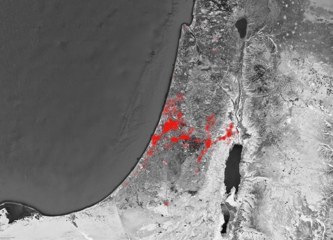
Urban Encounters: Imaging the City in Mandate Palestine                                           365

   The 1938 report explicitly links the targeting of the Old City to the socio-
economic status of its inhabitants, which it describes as ‘the toughest of all
Arab elements, consisting mostly of boatmen of Greek descent who earned
their living handling lighters in the Port of Jaffa, a difficult and dangerous occu-
pation’.12 It was this population in particular that suffered from the increased
rivalry between Jaffa and its nearby new Jewish settlement of Tel Aviv. After the
start of the British Mandate, Tel Aviv benefited immensely from the relaxed
British policies towards Jewish immigration and development – all at the
expense of Jaffa. In the early 1930s, schemes were made public for the con-
struction of a new port in Tel Aviv, just north of Jaffa’s historic Arab port.13
Hence, while the report describes the Old City’s inhabitants’ ‘natural dislike
for authority,’ it also admits the role of the ‘shadow of a harbourage scheme for
Tel Aviv, which appeared likely to strike directly at the livelihood of the Jaffa
boatmen’ in instigating their rebellion against the British administration.14
   The targeting of the Old City was influenced not only by British attitudes
towards the Old City’s inhabitants but also towards its architecture. Unlike the
broad avenues, detached buildings, open public squares and grid-like layout
that characterised Jaffa’s modern neighbourhoods, or the New City, the Old
City was ordered according to a considerably different spatial logic. As with
many historic cities of the Eastern Mediterranean whose main fabrics were
built before the nineteenth century, the Old City of Jaffa is more densely built,
and its roads are not straight and often end in cul-de-sacs. For the British, the
fabric of the Old City provided an ‘ample opportunity’15 for its inhabitants’
ability to conduct rebellion activities:

       Built upon a low hill flanked on one side by the sea, it completely domi-
       nated the Port and such buildings as the police station and barracks and
       the District Commissioner’s offices, which lay in the New City. Moreover
       its houses formed a veritable rabbit warren through which dark and
       narrow streets turned and twisted into a maze in which the level of one
       street would often be the roof of the houses in the one below and where
       few passages were so wide that they could not be spanned by the reach
       of a man’s arms. It represented in fact an exceedingly complicated trench

12		   Ibid., 156.
13		   Ibid.; for more on the historical relationship between the two cities of Jaffa and Tel Aviv,
       see Mark LeVine, Overthrowing Geography: Jaffa, Tel Aviv, and the Struggle for Palestine,
       1880–1948 (Berkeley: University of California Press, 2005); Sharon Rotbard, White City,
       Black City: Architecture and War in Tel Aviv and Jaffa (London: Pluto Press, 2015).
14		   ‘Military Lessons of the Arab Rebellion in Palestine 1936,’ 156.
15		   Ibid., 157.

                                                                                  Nadi Abusaada - 9789004437944
                                                                   Downloaded from Brill.com10/20/2021 01:08:28AM
                                                                                                    via free access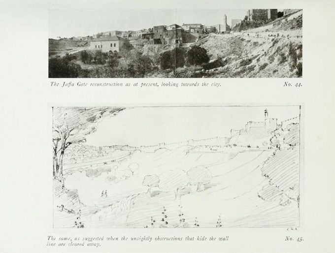
366                                                                                Abusaada

       system with vertical slides some thirty to forty feet high, which could
       readily be converted into a regular citadel.16

While aspects of this description are specific to Jaffa’s urban fabric, particularly
the proximity of the Old City to the port and its topographical advantage over
British administrative buildings in the New City, the negative attitude towards
the Old City’s ‘dark and narrow streets’ and ‘maze’-like layout are not uncom-
mon to British discourses surrounding poor urban quarters in the 1930s, an era
that witnessed an upsurge in ‘urban renewal’ projects and ‘slum clearances’ in
England.17 In fact, before the start of the operation, British aeroplanes dropped
down leaflets that described the demolitions as being ‘for the improvement
of the Old City’18 echoing these new discourses. Needless to say, however, the
nature and motivations of the operations at Jaffa, carried by a military force
and intended to serve imperial aspirations, were markedly distinct from slum
clearances in England that were carried on the basis of Housing and Town
Planning acts, despite their similar outcomes.
   The British divided their operations in Jaffa into four different phases: first,
a retaliatory offensive attack against houses from which fire had been directed;
second, the clearing of the approaches and cleaning up of the town at the edge
of the Old City; third, the driving of a road through the Old City from East to
West by means of demolition; and fourth, the driving of a similar road to run
North and South in a crescent shape.19 Significantly, these operations relied
heavily on a series of aerial photographs taken by a Royal Air Force Squadron.
These photographs, included in the British report on the operation, were used
to study the Old City of Jaffa from above – and to identify the exact areas where
the demolition activities in the operation’s third and fourth phases were to
take place (Fig. 11.2). Points labelled ‘A’, ‘B’, ‘C’ and ‘D’ were marked on the aerial
photographs, and lines were drawn connecting them indicating the buildings
to be demolished. Additional aerial photographs were taken following the
operation, showing the newly-opened arteries or, as the British called them,
‘good wide roads’ that aggressively ran through the heart of the Old City.20 It
was this operation, the British write in their report, that ‘mark[ed] the end of
organised resistance in the towns’ during the period of the revolt, before the
main rebel activities were transferred to the hills and the countryside.21

16		   Ibid., 157.
17		   Arthur Peter Becker, “Housing in England and Wales during the Business Depression of
       the 1930’s,” The Economic History Review 3, no. 3 (1951): 321–41.
18		   ‘Military Lessons of the Arab Rebellion in Palestine 1936,’ 158.
19		   ‘Military Lessons of the Arab Rebellion in Palestine 1936,’ 157–8.
20		   Ibid., 159.
21		   Ibid., 159.

                                                                             Nadi Abusaada - 9789004437944
                                                              Downloaded from Brill.com10/20/2021 01:08:28AM
                                                                                               via free access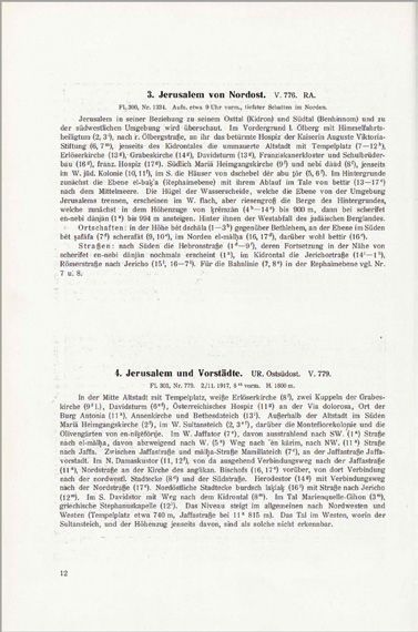
Urban Encounters: Imaging the City in Mandate Palestine                                       367

Figure 11.2		   ‘Jaffa Old City – The dotted line A-B marks the approximate line of the first
                Demolitions’
                Source: ‘Military Lessons of the Arab Rebellion in Palestine,’
                1936, 1938 IOR/L/MIL/17/16/16, British Library: India Office Records
                and Private Papers

Looking at the 1936 aerial photographs of Jaffa against British aerial photo-
graphs from the Great War reveals the shifting official British attitude towards
the cities of Palestine, from one that deliberately avoided urban destruction
to the taking of drastic measures against an urban population and their city.
Aerial photography, a practice that paralleled the developments in warfare
technologies during the Great War, has enabled a different view of cities that
changed the relationship between photography and the city. Seeing the city
from above, while not sufficient for targeting cities, has played a considera-
ble role in enabling such targeting where the necessary power for it became
available. Hovering over territories and capturing them from above enabled
the representation of places that are inaccessible at ground-level. Clearly,
aerial power was not limited to photography (e.g. direct bombardment), and
photography that enabled the targeting of cities was not limited to aerial
photography (e.g. ground photographic surveillance). Nonetheless, it was the
culmination of aerial power and photography that produced the most effec-
tive results in targeting urban spaces. With these representations, operations
on the ground became more informed, and hence more prone to success –
qualities that proved especially useful for the Germans and the British in the
context of the Great War and the British taming of the Great Revolt in Palestine.

                                                                              Nadi Abusaada - 9789004437944
                                                               Downloaded from Brill.com10/20/2021 01:08:28AM
                                                                                                via free access
368                                                                                    Abusaada

2         Holistic Views and Colonial Planning

The militaristic targeting of urban spaces during the Great War and in the
interwar period presented what is arguably the most direct, and violently
destructive, form of imperial and colonial confrontation with Palestine’s urban
landscape in the interwar period. Nonetheless, it was not the only, or even most
significant, shift in representations of and interventions in Palestine’s urban
landscape that paralleled interwar photographic developments. In this period,
photography, and especially views from above that provided a vue d’ensemble –
a comprehensive picture of the landscape – proved to be an instrumental tool
for the development of what Jeanne Haffner identifies as a new ‘science of
social space’22 which, though critical for militaristic and warfare operations,
was also crucial for the work of professionals interested in the scientific study
and intervention in the urban landscape, including archaeologists, planners,
engineers and architects. These ‘scientific’ approaches to photography and
the urban landscape were particularly significant in the context of Palestine,
whose urban landscape had been primarily approached by European
Orientalists in the nineteenth century as the Biblical Holy Land.23
   In Palestine, aerial photography proved instrumental not only for the emer-
gence of new methods of urban representation, but also interpretation, that
departed from typical Biblical frameworks. The first extensive publication
to scientifically interpret the aerial photographs and the vue d’ensemble of
Palestine’s urban landscape for non-militaristic purposes after the Great War
was Gustaf Dalman’s 1925 book, Hundert deutsche Fliegerbilder aus Palästina.24
Dalman, a German Lutheran theologian and archaeologist, had a long

22		 Jeanne Haffner, The View from Above: The Science of Social Space (Cambridge: MIT Press,
     2013).
23		 See in this volume chapters by Yazan Kopty, Sary Zananiri, and Karène Sanchez
     Summerer and Norig Neveu; Beshara Doumani, “Rediscovering Ottoman Palestine:
     Writing Palestinians into History,” Journal of Palestine Studies 21, no. 2 (1 January 1992):
     5–28.
24		 Archaeological efforts were a key element of Ottoman-German interest during the war.
     Under the instructions of the German archaeologist Theodor Wiegand (1864–1936), who
     served as a captain of the Ottoman-German militia artillery in the Asia Corps, Bavarian
     aeroplanes captured photographs of some of the main archaeological sites in the region.
     In 1918, based on a direct order from Djemal Pasha, Wiegand published Alte Denkmäler
     aus Syrien, Palästina und Westarabien, a bilingual Ottoman-Turkish and German book.
     The book included two sections: an introduction by Djemal Pasha in which he states
     some administrative measures he took to improve the preservation of historical monu-
     ments and to ‘protect them’ from the Allies, and a commentary essay by Wiegand, based
     on a series of one hundred illustrations (mainly photographs) of major archaeological
     sites and textual descriptions. See Theodor Wiegand and Ahmed Djemal Pascha, Alte

                                                                                 Nadi Abusaada - 9789004437944
                                                                  Downloaded from Brill.com10/20/2021 01:08:28AM
                                                                                                   via free access
Urban Encounters: Imaging the City in Mandate Palestine 369
experience working in Palestine before the war where he worked as the first
director of the Jerusalem-based German Protestant Institute for the Study of
Archaeology in the Holy Land (DIEAHL), founded in 1900.25 During his time
in Palestine, Dalman led several excavations at archaeological sites around
the country, took hundreds photographs and glass slides, and published
numerous academic writings including the annual volumes of DIEAHL’s
Palestine Yearbook.
In the book, Dalman explicitly expresses his criticism of mainstream pro-
ductions and photobooks of Biblical sites in Palestine produced by other
Orientalists. Crucially, Dalman celebrates the role of nineteenth century
photographic imagery of Palestine including, for example, the work of the
Beirut-based Bonfils photographic studio, in replacing the ‘fantasy images’
and ‘romantic depictions’ of Biblical sites and landscapes.26 For Dalman,
these early photographs hold a ‘special value’ because they depict cities and
their surroundings before they became ‘heavily disfigured by the effects of
Europeanization’.27 Describing urban change in Nazareth, he writes, ‘today’s
Nazareth is almost in the style of an Italian town, entirely unlike the image
of Nazareth around 1870, which is in two large photographs before me, and
so uncharacteristic that I found it difficult to recognise the details, though
I visited Nazareth twice in 1899’.28
Despite his appreciation for these early photographs, Dalman does not
shy away from expressing his reservations about the works of professional
photographers in Palestine. He is critical of the tendency in photographic pub-
lications to exclude descriptions of what is being represented, the direction in
which the photograph is taken or the exact time of recording the landscape.29
In addition, he also problematises the one-sidedness of their attitudes toward
holy places and historical sites and the lack of reliable, unbiased, information
about their general situation or the nature of the land with which their history
is connected.30 ‘The professional photographers in Palestine,’ Dalman argues,
‘are too dependent on what geographically and historically uninformed
Denkmäler aus Syrien, Palästina und Westarabien: 100 Tafeln mit beschreibendem Text
(Berlin: G. Reimer, 1918).
25 “Foundation and First Aims (1900–1914),” German Protestant Institute of Archeology (blog),
20 July 2019, https://www.deiahl.de/ueber-das-dei/geschichte/1900-1914/.
26 Gustaf Dalman, Hundert Deutsche Fliegerbilder Aus Palästina (Gütersloh: Bertelsmann,
1925), 3.
27 Ibid., 3.
28 Ibid., 3.
29 Ibid., 3.
30 Ibid., 3.
Nadi Abusaada - 9789004437944
Downloaded from Brill.com10/20/2021 01:08:28AM
via free access370 Abusaada
tourists want to buy as souvenirs’, thereby producing piecemeal images of
‘antiquities’ without sufficiently addressing the history and geography of the
represented landscape.31
Dalman compiles a series of one hundred aerial photographs of Palestine’s
landscape, which to him presented an opportunity ‘not only to see landscapes
from above but to understand them’.32 For each photograph, Dalman added a
textual description of what is being represented, along with brief geographical
and historical information on each specific site and its surroundings. These
texts are not simply complementary, rather, they set the specific frame in
which the spectator would gaze towards the photographs and interpret them.
Dalman’s descriptions are mainly spatial: he outlined, for each photograph,
geographical features (topography and land and water features), the main
neighbourhoods shown, the main public buildings and architectural monu-
ments (hospitals, cemeteries, holy places, etc.) and the main routes leading in
and out of urban centres (Fig. 11.3). It situated the depicted area within its wider
regional context, including both the cities and the routes to their hinterlands
or nearby suburbs, including the German Colonies in Jerusalem and Haifa.
The fact that his main emphasis was on the vue d’ensemble of the geography
and topography of the urban landscape, rather than isolated historical notes
on these monuments, distinguished his book from the typical Biblical frame-
works in which Palestine and its landscape had been understood throughout
the nineteenth century.
As Dalman was preparing his study of Palestine’s landscape in Germany, in
Palestine, the British were devising new planning frameworks and policies for
their intervention in urban built fabrics. The British concentrated their new
planning policies on the city of Jerusalem, the religious and political capital
of Mandate Palestine. In 1917, Colonel Ronald Storrs was appointed as the first
military governor of Jerusalem. Storrs was heavily invested in the historical
preservation of Jerusalem’s built fabric.33 Already in the first weeks of the mili-
tary occupation, he announced a public notice intended to maintain the city’s
status quo in terms of construction activity. This was clear in the public notice
he announced in the first weeks of the occupation:
No Person shall demolish, erect, alter, or repair the structure of any build-
ing in the city of Jerusalem or its environs within a radius of 2,500 metres
31 Ibid., 3.
32 Ibid., 4.
33 Sir Ronald Storrs, Orientations (London: I. Nicholson & Watson, 1939).
Nadi Abusaada - 9789004437944
Downloaded from Brill.com10/20/2021 01:08:28AM
via free accessUrban Encounters: Imaging the City in Mandate Palestine 371
Figure 11.3 Example of two pages from Gustaf Dalman’s 1925 book, including descriptive texts for two
aerial photographs of Jerusalem
Source: Gustaf Dalman, Hundert Deutsche Fliegerbilder Aus Palästina
(Gütersloh: Bertelsmann, 1925), 12–13
from the Damascus Gate (Bab al Amud) until he has obtained a written
permit from the Military Governor.34
The notice was only intended as a temporary measure until matters of town
planning and building policies in Jerusalem were sorted. In 1918, Storrs
established the Pro-Jerusalem Society (1918–1926) which was aimed at: ‘the
preservation and advancement of the interests of Jerusalem, its district and
inhabitants’ and avoiding potential conflict between the different ethnic
groups in Jerusalem.35 Storrs also appointed Charles Ashbee, a British architect
34 Charles Robert Ashbee, ed., Jerusalem, 1918–1920: Being the Records of the Pro-Jerusalem
Council During the Period of the British Military Administration (London: J. Murray, for the
Council of the Pro-Jerusalem Society, 1921), v.
35 Ibid., vii.
Nadi Abusaada - 9789004437944
Downloaded from Brill.com10/20/2021 01:08:28AM
via free access372 Abusaada
and planner, as the society’s Civic Advisor and Secretary. These two decisions,
it would later turn out, were incredibly significant for the future development
of the city and would have a lasting effect on its inhabitants in the decades
that followed.
At the time of his appointment, Ashbee, a friend and disciple of William
Morris, was already known for his skill and enthusiasm for the Arts and Crafts
movement of the late nineteenth and early twentieth centuries. In Britain, he
was also a member of the Society for the Protection of Ancient Buildings and
the National Trust. Though his stay in Jerusalem for a few years was short com-
pared to the three decades of British rule over Palestine, his visions for the
future of the city and its inhabitants, inspired by the Arts and Crafts movement,
albeit accommodated for the context of Palestine, remain highly relevant for
understanding the terms in which the British approached the city and its phys-
ical fabric in the years of military occupation and in the early stages of the
civil administration.36
Crucially, Ashbee paid considerable attention to photographic materials
and utilised them extensively in documenting, studying, and planning urban
developments in the city of Jerusalem. This is evident in his Palestine notebook
and two published reports he edited of the work of the Pro-Jerusalem Society,
documenting their work in Jerusalem during the initial period of British mili-
tary occupation (1918–20) and the first two years of the Mandate (1920–22).37
The two reports include long sections on urban planning activities written by
Ashbee, in addition to a number of short essays written by other European
practitioners and scholars of archaeology and architecture in Palestine. In
the sections written by Ashbee, he included several sub-sections reporting
on the works undertaken under his supervisions reflecting, for the most part,
his assessment of these works and visions for the future of the city. These were
accompanied by sketches he drew and photographs that were mostly captured
by American Colony photographers.
A key aspect of Ashbee’s vision for Jerusalem is his clear distinction
between the ‘Old City’ and the ‘New City’. Ashbee’s attitude towards the Old
City, however, was not like the British attitude towards Jaffa in the 1930s. It
rather stemmed, for the most part, from his architectural and archaeological
36 Wendy Pullan and Lefkos Kyriacou, “The Work of Charles Ashbee: Ideological Urban
Visions with Everyday City Spaces,” Jerusalem Quarterly 39 (2009): 51–61.
37 Charles Robert Ashbee, A Palestine Notebook, 1918–1923 [1st ed.] (New York: Garden City,
1923); Ashbee, Jerusalem, 1918–1920; Charles Robert Ashbee, ed., Jerusalem, 1920–1922:
Being the Records of the Pro-Jerusalem Council During the First Two Years of the Civil
Administration (London: J. Murray, for the Council of the Pro-Jerusalem Society, 1924).
Nadi Abusaada - 9789004437944
Downloaded from Brill.com10/20/2021 01:08:28AM
via free accessUrban Encounters: Imaging the City in Mandate Palestine 373
interest in the city’s historic centre and his desire to preserve it from potential
destruction: ‘the disaster of the Great War has forced upon all men and women
the necessity of preserving all that is possible of the beauty and the purpose,
in actual form, of the civilisations that have passed before.’ To him, however,
this was not a ‘mere matter of archaeology or the protection of ancient build-
ings’. As an active member of the Arts and Crafts movement, he also believed
in preserving urban ideals from the ‘blind mechanical order’ which, to him,
threatened the destruction of everything associated with ‘beauty’, that is, the
‘landscape, the unities of streets and sites, the embodied vision of men that set
the great whole together, [and] the sense of colour which in any Oriental city
is still a living sense’.38
What is noteworthy about Ashbee’s work in Jerusalem is not only what
he envisioned for the city, but also the tools he used to articulate his visions.
Photography was arguably one of the most important tools for him. Unlike
Dalman, Ashbee’s vue d’ensemble of Jerusalem’s relied not on aerial photo-
graphs, but ground panoramic photographs taken from elevated positions by
his staff and by American Colony photographers. For Ashbee, these panora-
mas were an essential medium to establish a visual hierarchy of what ought to
be seen and what was deemed a visual nuisance. Since Ashbee treated the Old
City as a ‘unity in itself’ that had to be protected from the encroachments of the
New City, many of his plans were concentrated on the contact zone between
the Old and New quarters.39 In addition to his suggestions for the creation of a
green buffer belt around the Old City’s historical walls, Ashbee paid consider-
able attention to the opening-up of the panoramic views towards the Old City
when it is approached from the New City. Two of his photograph-sketch com-
positions published in the 1921 report of the Pro-Jerusalem Society illustrate
the primacy of the visual relationship between the Old City and the New City
in his urban visions.
The first composition depicts a view of Jerusalem approached from
south-west, on the Jaffa road (Fig. 11.4). The panoramic photograph depicts the
view in its present state, overlooking the citadel, the Ottoman clocktower, the
Old City – all at a higher elevation than the valley from which the photograph
is captured. Some buildings also appear outside of the Old City, blocking parts
of the view of the historic walls. Next to the photograph, Ashbee includes a
photo caption: ‘the Jaffa Gate reconstruction as at present, looking towards the
city’, omitting the Ottoman clocktower, which Ashbee had been mobilising
for its destruction. Below the photograph, he sketched his own vision of the
38 Ashbee, Jerusalem, 1918–1920, 4.
39 Ashbee, Jerusalem, 1920–1922, 1.
Nadi Abusaada - 9789004437944
Downloaded from Brill.com10/20/2021 01:08:28AM
via free access374 Abusaada
panorama captioned: ‘as suggested when the unsightly obstruction that hides
the walls are cleaned away’. In the sketch, the ‘obstructive’ buildings of the New
City do not appear, and the citadel and the city’s historic walls appear enlarged
and more visible.
The second composition similarly depicts the approaches to the Old City
overlooking the road to Bethlehem, but in the opposite direction (Fig. 11.5). The
photograph, captured from an elevated viewpoint outside the historical walls,
shows Jaffa gate, the citadel, an informal Arab market, and Bethlehem in the dis-
tance. Ashbee notes: ‘the Jaffa gate reconstruction at present, looking towards
Bethlehem’. Below, Ashbee adds his own diagram of the view of the road he had
in mind. He explains: ‘the same, as suggested after the removal of the market to
the other side of the road’ reflecting, not only the desire for their destruction, as
the case with the first composition, but also their relocation into a more formal
market arrangement. In the report, Ashbee even includes several architectural
schemes for new formal markets both in the Old and New cities to replace such
informal arrangements with formal market schemes with ‘definite boundaries’
to conceal them away from the approaches to the Old and New cities.40
In a sense, Ashbee’s vision for the city of Jerusalem, despite its more critical
stance regarding architecture and its basis on rigourous study, did not radically
depart from its representation by European visitors in the late nineteenth cen-
tury as an ‘open-air biblical museum.’41 Like these visitors, who would often
climb the Mount of Olives to admire the panoramic view over the ‘city of Jesus’,
Ashbee’s plans and sketches for Jerusalem reflect more interest in distant views
of the city than in the conditions of its local inhabitants. The two panoramic
photographs captured from the perspective of an outsider entering the city
attest to this. As with Dalman’s ‘scientific’ analysis of aerial photographs, this
physical distance raises an important question regarding the manifestations
of relations of power in representations of the urban landscape. Both Ashbee
and Dalman dismiss the role or fate of the local inhabitants in their representa-
tions of the urban landscape. While in Dalman’s distant photographs the Arab
population makes no appearance and their architectural contribution is not
mentioned, in Ashbee’s compositions, they are either depicted as ghostly sil-
houette figures in the landscape, or as a population whose building activity
poses an obstruction to romanticised and sanitised colonial visions of the
Holy City.
40 Ibid., 26.
41 Vincent Lemire, Jerusalem 1900: The Holy City in the Age of Possibilities (Chicago: University
of Chicago Press, 2017), 55.
Nadi Abusaada - 9789004437944
Downloaded from Brill.com10/20/2021 01:08:28AM
via free accessUrban Encounters: Imaging the City in Mandate Palestine 375
Figure 11.4 Above: ‘The Jaffa Gate reconstruction as at present, looking towards the city.’
Below: ‘The same, as suggested when the unsightly obstruction that hides the
walls are cleaned away’
Source: Charles Robert Ashbee, ed., Jerusalem, 1918–1920: Being
the Records of the Pro-Jerusalem Council During the Period of
the British Military Administration (London: J. Murray, for the
Council of the Pro-Jerusalem Society, 1921)
3 The City in Print and Arab Self-Image
Photographs of urban spaces and landscapes, particularly distant aerial and
panoramic views, proved instrumental for reifying imperial and colonial rep-
resentations of the urban landscape and the carrying out of colonial urban
counterinsurgency activities and planning projects. It would be false, however,
to assume that photography and photographic representations of urban land-
scapes in interwar Palestine were a product of and served colonial interests
alone. Palestine’s native Arab population, particularly urbanites, also utilised
the power of photographic imagery in this period to articulate their own con-
ceptions and visions for Arab nationhood, modernity and progress in the
interwar period. These new national conceptions and visions were undoubt-
edly shaped by the native populations’ desire to respond to colonialism and
Nadi Abusaada - 9789004437944
Downloaded from Brill.com10/20/2021 01:08:28AM
via free access376 Abusaada
Figure 11.5 Above: ‘The Jaffa gate reconstruction at present, looking towards Bethlehem.’
Below: ‘The same, as suggested after the removal of the market to the other
side of the road’
Source: Charles Robert Ashbee, ed., Jerusalem, 1918–1920: Being
the Records of the Pro-Jerusalem Council During the Period of
the British Military Administration (London: J. Murray, for the
Council of the Pro-Jerusalem Society, 1921)
colonial imagery. However, they were also the product of internal social and
class shifts and ruptures among urban populations, particularly the rise of a
new urban middle class of effendiyya with new forms of social and cultural
values, systems of identification and forms of expression.42
Most works that address the rise of ‘vernacular’ photographic imagery in late
nineteenth and early twentieth century Palestine focus on family portraits.43
This is not surprising given that, with only a few exceptions like the works
of Khalīl Raʿad and Ḥannā Ṣāfiyya,44 Arab photographers in Palestine and
the region were much less interested in the photography of cities and urban
42 On the expressions of these socioeconomic shifts in the realm of portrait photography,
see Stephen Sheehi, The Arab Imago: A Social History of Portrait Photography, 1860–1910
(Princeton: Princeton University Press, 2016), xxiv.
43 Issam Nassar, “Familial Snapshots: Representing Palestine in the Work of the First Local
Photographers,” History & Memory 18, no. 2 (2006): 139–155.
44 See the chapters of Rona Sela and Issam Nassar in this volume.
Nadi Abusaada - 9789004437944
Downloaded from Brill.com10/20/2021 01:08:28AM
via free accessUrban Encounters: Imaging the City in Mandate Palestine 377
landscapes than they were in the production of studio portraits and the pho-
tography of weddings and social events.45 Nonetheless, in the 1930s and 40s,
an era marked by an increased confrontation with the Zionists and the British,
and a growing interest by the local Arab population in taking part in urban
affairs and projects, the reproduction of photographic materials that depict
urban events and built forms played an instrumental role in Arab expressions
for their desire for the building of their national consciousness and institutions,
and countering their depiction as ‘unprogressive’ and ‘backward’ in British and
Zionist imagery of Palestine.46 Hence, from the 1930s onwards, numerous Arab
publications surfaced that included photographs of urban events and spaces
as a form of documentation and evidence of both colonial repression of urban
populations and progressive Arab-led urban-based national activities and pro-
jects, targeted at audiences both within and beyond Palestine.
Among the Arab-led urban activities that received extensive coverage across
Arab print media in Palestine were the organisation and inauguration of the
1933 and 1934 National Arab Exhibitions in Jerusalem. Held at a critical period
between the 1929 Buraq Revolt and the 1936 Great Revolt, the two exhibitions
‘were intended to demonstrate that Arab countries were witnessing remarkable
innovations in the industrial and agricultural sectors despite, and not because
of, European colonisation’.47 The British administration, which had previously
partnered with the Zionists on several exhibitions in Palestine and abroad,
refused to endorse the exhibition and even placed several hurdles in the way of
its execution.48 Hence, the exhibitions were entirely financed, organised and
executed by Palestine’s new group of Arab urban middle class elites who were
leading Palestine’s Arab national and economic Nahda (‘renaissance’).49
With the two exhibitions, the organisers intended to boost economic devel-
opment, with political end goals, at both the national and urban levels. On
the one hand, the exhibitions were executed with the aim of forging new
economic bonds between the Arab countries that had been fragmented and
disconnected in the Great War. At the same time, the organisers were aware of
45 Issam Nassar, “A Jerusalem Photographer: The Life and Work of Hanna Safieh,” Jerusalem
Quarterly 7 (2000): 26.
46 Mark LeVine, “The Discourses of Development in Mandate Palestine,” Arab Studies
Quarterly (1995): 95–124.
47 Nadi Abusaada, “Self-Portrait of a Nation: The Arab Exhibition in Mandate Jerusalem,
1931–1934,” Jerusalem Quarterly 77 (2019): 122.
48 There were many hurdles. Besides refusing some of the plans for the exhibition by the
Town Planning Commission, the British administration also rejected the allocation of
municipal funds for the exhibitions. Ibid., 128.
49 Ibid., 128.; Sherene Seikaly, Men of Capital: Scarcity and Economy in Mandate Palestine
(Stanford: Stanford University Press, 2015).
Nadi Abusaada - 9789004437944
Downloaded from Brill.com10/20/2021 01:08:28AM
via free access378 Abusaada
the specific threats taking place in Palestine, and the significance of organising
an event of this sort in one of the country’s main urban centres. The relation-
ship between the exhibitions and the city was a key issue since the former’s
earliest articulations. While the initial intent was to host the exhibition in Jaffa,
in close proximity to the Zionist Levant Fair in Tel Aviv, after several debates
and conflicts, the final decision was made to host the exhibitions at the Palace
Hotel in Jerusalem, a building owned and run by the Supreme Muslim Council
(SMC) – the primary representative body for Palestine’s Arab population at the
time.50 Taking place only a few years after the Buraq revolt, and in the context
of the turbulences of 1933, hosting the Arab exhibition in Jerusalem was a clear
statement regarding the Arab claim over the city and its public sphere.
A photograph of the opening of the second exhibition in 1934 from the
private collection of Saʿid Ḥusaynī illustrates the urban nature of the event
(Fig. 11.6). In the photograph, a large crowd of men appear to have gathered
outside the Palace Hotel building, the venue where the two exhibitions were
held, to celebrate the second exhibition’s inauguration. The building is deco-
rated with flags and two banners that read ‘the second Arab exhibition’ and
‘loving the nation is an act of faith’. A vertical distance appears between the
crowds outside the gate and the fewer individuals who occupied the build-
ing’s front balcony. Numerous Arabic newspaper articles covered details of the
opening ceremony, which included a speech by ʿAjāj Nuwayhiḍ, a member of
the exhibition’s board of directors, on the board’s behalf. In his speech, fully
transcribed by the Jerusalemite al-ʿArab newspaper, Nuwayhid emphasised
the ‘Arab-ness’ of the city and the event, thanked its supporters, welcomed
its visitors from across the country, and explained the motivations behind the
exhibition as ‘developing Arab capital, rejuvenating national projects, sup-
porting Arab labourers by strengthening Arab factories, supporting artists and
innovators to make use of their talents, and consolidating economic bonds
between Arab sectors to achieve Arab economic independence’.51
The numerous Arabic newspaper articles that covered the opening of
the first and second exhibitions included multiple photographs, predomi-
nantly focused on the Palace Hotel’s exterior and interior spaces. Built by the
Supreme Muslim Council and registered as a Waqf property, the Palace Hotel
was distinguished in its architectural style and location. It was designed by two
well-known Turkish architects, Ahmet Kemaleddin and his disciple Mehmed
Nihad, who had initially arrived in Jerusalem to lead the renovations in Haram
50 Abusaada, “Self-Portrait of a Nation: The Arab Exhibition in Mandate Jerusalem, 1931–
1934,” 128–129.
51 al-’Arab, ‘khitab al-iftitah’, 14 April 1934.
Nadi Abusaada - 9789004437944
Downloaded from Brill.com10/20/2021 01:08:28AM
via free accessUrban Encounters: Imaging the City in Mandate Palestine 379
Figure 11.6 ‘A black-and-white photograph of a crowd gathered in front of al-Awqaf,
Maʾman Allah St during the opening of the Second Arab Industrial Exhibition,
in 1934, in Palace Hotel, in response to the Zionist Exhibition which had
opened in Tel Aviv’
Source: Said al-Husseini Collection, Palestinian Museum
Digital Archive. Image courtesy of the PALESTINIAN Museum
al-Sharif.52 It was the largest and most grandiose Arab building in Palestine
constructed in the era of the British Mandate. The hotel’s location on Mamilla
Street in what Charles Ashbee has defined as the New City outside the his-
torical walls of Jerusalem, in the vicinity of new Jewish neighbourhoods and
colonial construction projects, was a clear statement about the Arab claim
over the New City and participation in Jerusalem’s extra-muros modern devel-
opments and tourism industry. The building was also of regional significance.
In 1931, the Islamic Congress bringing leaders from all over the Muslim world
was held at the Palace Hotel. With this in mind, it is not surprising that the
hotel figured extensively in the exhibitions’ photographic and textual rep-
resentations, both in the Arabic press and in the official manuals prepared for
the two exhibitions, and was described as an emblem for Arab national pro-
gress and cultural renaissance.53
52 Yıldırım Yavuz, “The Influence of Late Ottoman Architecture in the Arab Provinces: The
Case of the Palace Hotel in Jerusalem,” Proceedings of the International Congress of Turkish
Arts 1 (2003): 1–22.
53 On 15th July 1933, an article appeared in al-Arab that included a series of three photographs
of the Palace Hotel at the time of the first exhibition, with the following accompany-
ing captions: ‘the view of the Waqf Hotel, where the exhibition is held. The building is
Nadi Abusaada - 9789004437944
Downloaded from Brill.com10/20/2021 01:08:28AM
via free access380 Abusaada
The press coverage and photographic representations of the Arab exhibi-
tions in the early 1930s were mainly directed towards an Arabic readership
within Palestine. Nonetheless, this audience was not the only target that Arab
urbanites wanted to reach in this period. The British support for the Zionist
movement was a growing concern among Arab intellectuals and politi-
cians, both those who resided in Palestine and abroad. By the 1930s and 40s,
Palestinians had realised the extent of Zionist propaganda outside of Palestine.
Its representations at multiple World Fairs around the world at that time was
one of many indicators of the power of the Biblical image of Palestine that they
had presented to the world, as a deserted land that required Zionist colonial
settlement and modernisation. Hence, by the mid 1930s and early 40s, there
was an increased desire by key Arab figures to counter the image of British
Mandatory rule and Zionist settler colonialism as ‘civilised’ and ‘modern’
regimes not only in Palestine, but also abroad, particularly in Europe and the
United States.
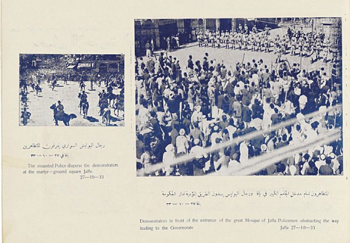
In October 1933, only three months after the inauguration of the first Arab
exhibition in Jerusalem, major Arab demonstrations took place in Jerusalem
and Jaffa, initiated by the Arab Executive Committee’s call for a national
strike to protest British policy regarding Zionist settlement in Palestine. By
November, the demonstrations escalated and spread to other principal urban
centres including Haifa and Nablus and were met by extreme use of force
by the British Police Force in Palestine. Like the Arab exhibitions, the events
received considerable attention in local Arabic newspapers, detailing both
protest activities and British acts of repression. Unlike the coverage for the two
Arab exhibitions, however, reporting on the 1933 demonstrations was predom-
inantly textual, and lacked photographic materials. Realising this gap, by the
end of 1933, Theodore Sarrouf, an Arab nationalist and the founder of the Press
and Publication Office in Jaffa, one of the first Arab advertising agencies of its
kind in the country, began collecting photographs of the October-November
demonstrations with the purpose of their publication.
On 12th January 1934, Sarrouf published a 43-page photographic album of
the 1933 demonstrations.54 The album’s pages included tens of photographs
constructed in the glamorous Arab-style, consists of four stories, and it costed no less
than 70,000 Palestinian pounds and rented annually for about 8,000 pounds’; ‘a view
of the large lobby on the ground floor before the exhibition was held’; and ‘upon entering
the building, the visitor is faced with a spectacular elevated dome, scraping the clouds,
and this is its photograph.’ ‘al maʾrad al-ʾarabi al-awwal (‘the first Arab exhibition’)’,
al-Arab, 15 July 1933: 21–30, 22, 26.
54 Theodore Sarrouf, Photographs of the Demonstrations Which Took Place in Palestine 1933
(Jaffa: Press and Publication Office, 1934).
Nadi Abusaada - 9789004437944
Downloaded from Brill.com10/20/2021 01:08:28AM
via free accessYou can also read