Regional Urbanisation through Accessibility?-The "Zweite Stammstrecke" Express Rail Project in Munich - MDPI
←
→
Page content transcription
If your browser does not render page correctly, please read the page content below
Article
Regional Urbanisation through Accessibility?—The
“Zweite Stammstrecke” Express Rail Project
in Munich
Fabian Wenner * , Khoi Anh Dang, Melina Hölzl, Alessandro Pedrazzoli ,
Magdalena Schmidkunz, Jiaqi Wang and Alain Thierstein
 Department of Architecture, Technical University of Munich (TUM), D-80333 Munich, Germany;
 khoianh.dang@tum.de (K.A.D.); melina.hoelzl@tum.de (M.H.); alessandro.pedrazzoli@tum.de (A.P.);
 magdalena.schmidkunz@tum.de (M.S.); ge46xan@mytum.de (J.W.); thierstein@tum.de (A.T.)
 * Correspondence: f.wenner@tum.de

 Received: 1 December 2019; Accepted: 3 January 2020; Published: 8 January 2020

 Abstract: Transport accessibility is one of the most significant locational factors for both households
 and firms, and thus a potentially self-reinforcing driver of urban development. The spatial structure
 and dynamics of accessibility hence have the potential to alter the locational choices of households
 and firms significantly, leading to concentration and de-concentration processes. In spite of recent
 innovations in automotive technologies, public transport systems remain crucial for the functioning
 of metropolises. In this paper, we use the case of public transport in the Munich Metropolitan Region
 (MMR) in Germany to (1) discuss whether public transport in the past has contributed to regional
 urbanisation, the blurring of urban and suburban spaces; (2) model future accessibility changes
 due to the ongoing mega-infrastructure project “second trunk line” (“Zweite Stammstrecke”) for
 suburban trains and their likely effects on processes of regional development; (3) compare the balance
 of accessibility and functional density at stations in the MMR and (4) recommend a planning strategy
 based on an integrated urban and transport planning philosophy. We argue that particularly the
 monocentric design of the project means that it will intensify and extend the scope of suburbanisation
 and metropolisation, while planning should aim for a greater regionalisation of economic activity.

 Keywords: public transport; accessibility; railway stations; integrated urban and transport planning;
 commuting; metropolisation; suburbanisation; planning strategies

1. Introduction
      It is often argued that spatial dynamics in developed countries during the last decades are
characterised by new complexities. The seemingly clear-cut and hierarchical inner-regional relationship
between urban cores as employment centres and expanding residential suburban areas is increasingly
blurring and being supplemented by a new simultaneity of tendencies of employment de-concentration
and re-urbanisation of households. “Regional urbanization” [1] or “Zwischenstadt” [2] are some of the
labels given to these dynamics. This new parallelism of concentration and de-concentration can be
attributed to a range of factors, among them changes in the economic system such as the rise of the
knowledge economy [3], as well as demographic developments [4].
      New transport technologies and infrastructure are other important drivers of changes in regional
settlement structures. For households, transport infrastructure provides accessibility to jobs, services,
leisure and retail facilities, while for firms it provides access to (potential) employees, customers
and business partners, and hence constitutes an important locational factor. Transport networks
can be structured in a monocentric or polycentric way, which influences the regional distribution of

Urban Sci. 2020, 4, 2; doi:10.3390/urbansci4010002                            www.mdpi.com/journal/urbansci
Urban Sci. 2020, 4, 2                                                                               2 of 24

accessibility and subsequently settlement dynamics. In this paper, we discuss the relationship of patterns
concentration and de-concentration of households and employment with transport infrastructure
improvements, particularly public transport infrastructure, in an inner-regional perspective, using
the case study of the currently planned major passenger rail project “Second Trunk Line” (“Zweite
Stammstrecke”) in the Munich Metropolitan Region (MMR). There has been no analysis of this project
with regard to these dynamics in academic literature yet.
     First, we briefly discuss the theoretical background of four dynamics—de-concentration
and concentration of households and employment—separately and in their relation to transport
infrastructure improvements. We then introduce our case study area and project, including previous
studies on land use-transport relationships in the region, which mostly conclude that the MMR
continues to be a prime example of suburbanisation and metropolisation. We pose four research
questions in this paper, which are also reflected in the methods and results sections. (1) First, we ask
whether more recent data shows signs of changes for the MMR that point more into the direction
of re-urbanisation and regionalisation of economic activity than identified by previous literature.
We hypothesize that this is the case, as most of the previous studies on the topic for the MMR have
been published a while ago, and they predate the transition to the knowledge economy. Based on
the results, we (2) ask which dynamics and patterns of accessibility the “Second Trunk Line” project
produces, and which consequences for demand by different users of space are likely to result, using a
gravitational accessibility modelling method. Our hypothesis is that accessibility gains will accrue
mainly to those locations that already are highly accessible, due to the monocentric alignment of the
planned new rail line. We then take a more normative approach that seeks to balance accessibility and
functional density and (3) ask whether the current spatial structure still matches the new accessibility
opportunities levels in the region. (4) Lastly, we ask what regional planning should do in response
to these changing demands, based on recent integrated urban and transport planning philosophies
and draw conclusions for metropolitan regions in general. By doing so, we contribute to the growing
discussion in academic literature on sustainable urban structures.
     We conclude that despite slight tendencies for a dispersion of economic activity and a polycentric
development in the immediate surroundings of the city of Munich, the Second Trunk Line is going to
reinforce the monocentric alignment of the transport network in the MMR, which will likely cause
further suburbanisation and metropolisation. Since construction has already begun, planning should
mitigate the consequences using a strategy of transit-oriented development with a greater emphasis on
functional mix around the newly emerging accessibility hubs.

2. Theoretical Background
      Different strands within the spatial sciences discuss, on the one hand, the continuing
de-concentration of population away from urban cores (“suburbanisation”) as well recent indications
for its reversal (“re-urbanisation”). With regard to economic activity, both the concentration of economic
activities and employment, often between regions (“metropolisation”), and the de-concentration, often
within regions (“regionalisation”), are addressed but seldom together. Table 1 shows this categorisation
that will be used in this paper, which is based on the literature discussion in the following paragraphs.

            Table 1. Dynamics of concentration and de-concentration of households and employment.

                                            De-Concentration              Concentration
                        Households           Suburbanisation             Re-Urbanisation
                        Employment           Regionalisation             Metropolisation

2.1. Four Regional Dynamics of Concentration and De-Concentration
     Suburbanisation describes the separation of residential location and workplace by a relocation of
the residence from an urban core to a less densely populated area in the surroundings [5]. Models
Urban Sci. 2020, 4, 2                                                                                3 of 24

that explain suburbanisation with transport costs have a long tradition in spatial sciences. In the
monocentric model by Alonso [6], for example, an improvement of transport infrastructure between
the centre and the periphery leads in the medium to long run to an increase in city size through an
expansion along the infrastructure, leading to suburbanisation and an extension of the commercial
zones in the centre. An important precondition in the case of urban land uses is the observation that
commuters have a fixed time budget that they are willing to devote to travelling, commonly empirically
found to be slightly more than one hour across different spatial and temporal settings [7,8]. Lehner [9]
has shown for Berlin that transport improvements and the diameter of built-up space have throughout
the 19th and early 20th century indeed been directly correlated, each improvement in mass public
transit allowing longer commute distances and opening up new areas around the city for residential
development. However, while the (mostly rail-based) public transport infrastructure of this time
on a regional scale promoted a structure of discontinuous settlements along a number of axes, only
the spread of the car together with the expansion of road infrastructure from the middle of the 20th
century on allowed the continuous extension of built-up area around cities. Digitalisation, working
from home or while mobile and online shopping might further accelerate the spatial separation of
workplace and residential location and deteriorate the importance of urban centres [10]. Even though
the assumption of a single employment centre is a too crude simplification even for highly monocentric
city-regions [11] (see “regionalisation”), it can be concluded that regional transport infrastructure
increases the “daily urban space”, the number and scope of activities for its inhabitants, but in the
long run also the potential locations for households and firms, potentially causing longer commute
distances through suburbanisation and the large-scale separation and upscaling of urban functions.
      At the same time, there has been a surge in studies detecting at least a slow-down of suburbanisation
and an increased interest of (some groups of) households to remain in or return to the regional centres,
and within them to their urban cores, often labelled “re-urbanisation”. A stronger appreciation of
urban (cultural) amenities [12], a desire to co-locate with others of the same age group in times of
demographic change [4] and the advantages of highly-accessible urban locations for dual-income
couples and specialised knowledge workers in flexible employment conditions [13,14] are among the
reasons identified behind this development in the case of Germany. This is not necessarily related to
shorter commutes. Complex and atypical work mobility, especially reverse commuting to suburban
workplaces and long-distance commuting between centres, are on the rise [14–16]. Still, real estate
rental and purchase prices remain the highest in urban centres compared to their surroundings, at least
in most European cities, which is why students, young professionals, high-earners and creatives are so
far the main protagonists of re-urbanisation [5,17]. Re-urbanisation also does not necessarily mean a
change of lifestyles compared to “suburbia” in terms of dwelling type or mobility, as the examples
of “inner-city suburbanization” described by Frank [18] show. New regional transport infrastructure
hence increases the opportunities to combine peripheral work and inner-city residential locations,
particularly for high-income households, and increases the pool of potential employees for peripherally
located firms. Inter-regional and long-distance commuting play a major role for this.
      Regarding employment and innovation, the last two decades in regional sciences have brought
forth a number of contributions that underscore the role of agglomeration economies, inter-regional
competition and the interrelation between cumulative causation processes and network economies,
which altogether account for an increasing concentration in particular of knowledge-intensive
firms [19–22]. Notwithstanding digitalisation, face-to-face contacts remain the main channel for
the transfer of tacit knowledge [23–25]. The strengthened role of knowledge in economic processes
means that particularly spatial proximity to similar actors is valued more. “Metropolisation” describes
the increasing concentration of economic activity, especially high-paid knowledge-intensive jobs in a few
regions that are characterised by high international (air and high-speed rail) and internal connectivity,
quality of life and a skilled workforce [26–28] while other regions fall behind. There is hence an
implicit connection to re-urbanisation. While the effects of interregional transport infrastructure
on this development are ambiguous, as it always goes both ways and can potentially drain newly
Urban Sci. 2020, 4, 2                                                                                4 of 24

connected regions of their economic activity, inner-regional infrastructure is generally assessed to be
conductive to regional competitiveness [29] and advantages of agglomeration [30]. Aschauer [31] has
demonstrated strong multiplier effects of public infrastructure, particularly transport infrastructure, on
regional productivity. The boundary between inner- and interregional infrastructure is not always
clear, as each new piece of transport infrastructure also expands the (functionally defined) region.
This entails the possibility that remote towns become integrated into the hinterland of a neighbouring
centre in terms of workplace locations of the local population. While this is often seen negatively by
local actors, it can also be seen as a tool to alleviate spatial economic disparities, as every commuting
relation implies a reverse stream of income spent locally [32]. Nevertheless, there can also be effects
of improved networks on the distribution of functions within regions. Generally, they are found to
be in favour of the largest city, especially when it is small in population size (“borrowed size”), even
though local population size remains the most important factor for endowment with workplaces and
urban functions [33,34]. Particularly, Munich has been found to be a case of borrowing size within its
region [35].
      While an increased premium for agglomeration means that firms still demand highly urban
locations, diseconomies of agglomeration, such as overburdened transport systems, a lack of building
space or a scarcity of skilled employees, which receive little attention in spatial sciences [1], are among
the most important reasons for firms to relocate to suburban settings (“regionalisation”, [36]) or even
an overspill to more remote regions, as a study by Prognos just found for Germany [37]. Garreau [38]
uses the term “edge cities” to describe new employment centres on the fringes of the suburbanising
city—typically with high car-accessibility. Particularly, new hubs of international connectivity outside
of cities, such as airports, have been nuclei of these developments, which increasingly provide both
agglomeration and (relational) network economies to firms. In the long run, this can give rise to
polycentric mega-regions [39] with multiple employment centres and dispersed commuter relations,
often difficult for public transport to serve. However, European edge cities are found to have not (yet)
reached the size and importance of their American counterparts [5], also due to the greater role of public
transport, whose sunk costs exert a preserving influence for existing centres. Even larger shopping
outlets are increasingly looking for inner-city locations again as consumer behaviour changes [40].
      It seems hence that despite similar tendencies [2], the dissolution of urban and suburban in
“regional urbanisation” as described by Soja [1] for the US might not be fully adequate for the European
context [41]. Rather, “classical” residential suburbanisation still plays a major role [4,5], albeit in
parallel to a selective re-urbanisation to the traditional cores [42], while agglomeration economies
mean an increased concentration of employment. Polycentric regions, where they have emerged, more
commonly resulted from an already existing urban pattern of cities with similar size and in greater
proximity to each other with the advances of transport technology.

2.2. Integrated Urban and Transport Planning as Sustainable Regional Development Strategy
     In urban and regional planning, such polycentric, networked regions are often seen as a strategy—a
normative potential to sustain a high degree of agglomeration advantages without having to bear too
much of the costs of overcrowding (“Decentral Concentration”), [43–47]. It is important to note that
such concentration can occur on different spatial scales, from within-city to the regional scale. Such a
decentral organisation of space is assumed to entail a range of social and environmental benefits as
well, provided the urban areas are functionally and socially mixed, adequately dense, and interlinked
by public transport.
     Even though the direction of causality between built environment and travel mode choice
remains disputed [17], mixing and densification, especially through infill housing, is generally thought
to encourage social cohesion and avoid long commutes and hence traffic and should always take
precedence before transport infrastructure extensions. Particularly, if low-density areas are connected
to urban cores, the “spatial drag” is reduced, which risks urban sprawl, longer commutes, more traffic
and a decomposition of uses [48]. Hence, transport infrastructure extensions require cautious planning.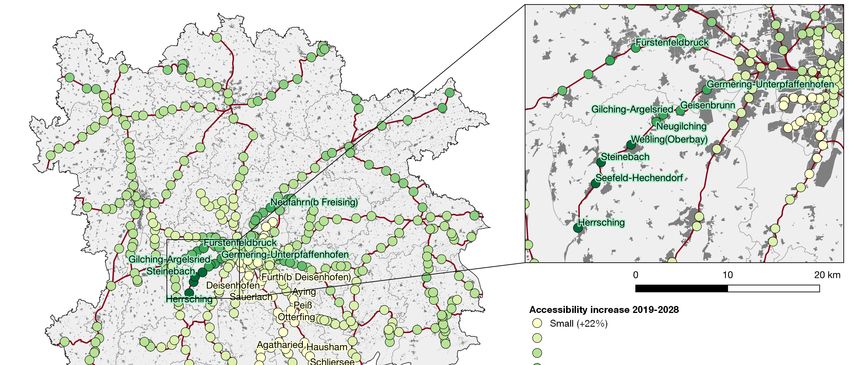
Urban Sci. 2020, 4, 2                                                                               5 of 24

      Recent advances in car technology, such as battery-powered cars, car sharing or automated driving
will certainly alleviate some of the problems that individual transport causes in metropolitan areas,
such as local emissions. The inefficient use of urban public space for (often parking) private cars will
most likely, however, not change. Hence, public transport, particularly rail-based, still represents
an important element for the functioning of cities and regions for those connections that cannot be
covered locally by walking or cycling [49].
      Nevertheless, in some cases it might be necessary to extend transport networks. If suburbanisation
is happening anyways, it might be more environmentally friendly to channel it towards low-emission
rail-based public transport rather than car-dependent settlements. Additionally, at least once that
new public transport infrastructure has already been constructed, abandoning the generated urban
development potentials would be an inefficient use of resources. In overheated rental and real estate
markets, they can alleviate the burden on households.
      Nevertheless, this requires a coordinated regional action that involves all affected municipalities,
which might reject development for various reasons. Still, many decision-makers take a demand-side
view and see mostly the advantages that new transport infrastructure provides for the existing
population of a municipality, while too little attention is paid to new development potentials that are
created. As a result, “integrated location and transport planning” or “transit-oriented development” [50]
are now predominant planning approaches to coordinate settlement development with public transport
infrastructure investment to ensure that both residents and employees have at least the option to
use public transport and that transport infrastructure is used efficiently where it exists [51] (see also
“3. Materials and Methods”).

3. Case Study and Context
     The Munich Metropolitan Region (MMR), located in the south-east of Germany, is a functionally
defined region consisting of the city of Munich as the main employment, business and administrative
centre; its surrounding commuter belt and a ring of larger regional centres (among them Augsburg
and Ingolstadt). The regional centres are characterised by an own commuter hinterland but exhibit
strong functional relations with Munich in terms of business locations or common infrastructure, such
as the airport. It has an area of about 26,000 km2 and a population of about 6 million, while its main
centre, Munich, has a population of 1.55 million people in 2019 [52].
     The MMR is characterised by a strong local economy, with seven of the 30 firms in the main
German stock index DAX located in Munich. Compared with other metropolitan regions in the country,
its unemployment rate is low and the purchasing power considerably above average. It also regularly
appears on high positions in urban quality of living ratings [53,54]. This has resulted in continuous
growth with respect to both population and economy in the last decades, and it is among the few
German regions for which strong further population growth is expected in the future [55]. The strong
expansion of population and employment means that the MMR now suffers from growing pains.
Housing development has not kept up with the pace of immigration to the region, and real estate
prices are among the highest in Germany. This is despite strong suburbanisation that has occurred
since the 1960s.

3.1. Public Transport in the MMR
      In spite of the fact that the car manufacturer BMW is among the largest employers in the region,
the modal split shows significantly above average and growing shares for public transport and cycling
in both the core city Munich and the commuter belt, compared to other regions in Germany. As a result
of rising motorisation rates in the 1950s, actors such as the local chamber of industry and commerce
had recognised earlier than elsewhere the detrimental effects of car traffic on public space in the inner
city and advocated public transport investments instead [56]. Today, 15% of all journeys in the region
and 21% of all journeys in the city occurred using public transport; the figure rises to 51% for journeys
to/from the inner city [57]. The figures for car-use (as driver) are 35%, 27% and 8%, respectively. Given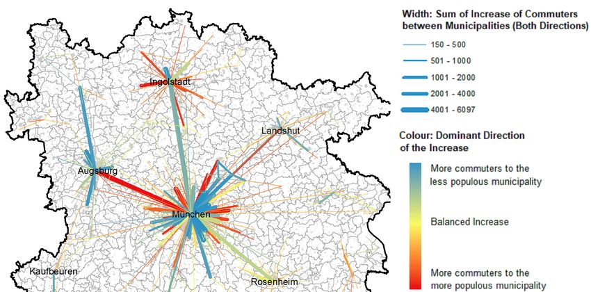
Urban Sci. 2020, 4, 2 6 of 24
the above-average usage of public transport, the system still exerts an influence on locational choices
for aSci.
Urban high2020,share of the
4, x FOR PEERregional
REVIEW population. 6 of 25
The transport system—both road and rail—has largely been constructed in a monocentric
The transport
alignment; there aresystem—both
few tangential road and rail—has
connections, exceptlargely
betweenbeen
the constructed in a This
regional centres. monocentric
transport
alignment; there are
network reflects thefew tangential
settlement connections,
patterns, and viceexcept
versa.between
The mostthe regionalregional
important centres. public
This transport
transport
network reflects the settlement patterns, and vice versa. The most important regional public
infrastructure is the “S-Bahn”-network of suburban railway lines. The network was initially constructed transport
infrastructure
as part of the is the “S-Bahn”-network
preparations of suburban
for the 1972 Olympic Gamesrailway lines.which
in Munich, The boosted
networkthewas initially
city’s public
constructed as part of the preparations for the 1972 Olympic Games in Munich, which
infrastructure, by consolidating and upgrading varyingly used existing suburban lines and linking them boosted the
city’s public infrastructure, by consolidating and upgrading varyingly used existing suburban
with an east-west tunnel below the city centre. It is now used daily by up to 840,000 passengers [58], lines
and linking
near them with
its capacity anBesides
limits. east-west
thetunnel
S-Bahn,below the city
the MMR centre.by
is served It isannow used daily
extensive by up
regional to 840,000
train network
passengers [58], near its capacity limits. Besides the S-Bahn, the MMR is served by an
(less frequent than the S-Bahn), local and regional bus lines, as well as underground and tram services extensive
regional
in Munichtrain network
(Figure 1). (less frequent than the S-Bahn), local and regional bus lines, as well as
underground and tram services in Munich (Figure 1).
Figure 1. Current and future rail infrastructure in the Munich Metropolitan Region (Source: own
Figure 1. Current and future rail infrastructure in the Munich Metropolitan Region (Source: own work,
work, using geodata by Bayerische Vermessungsverwaltung, Bundesamt für Kartographie und
using geodata by Bayerische Vermessungsverwaltung, Bundesamt für Kartographie und Geodäsie,
Geodäsie, Deutsche Bahn).
Deutsche Bahn).
3.2.
3.2.The
The“Second
“SecondTrunk
TrunkLine”
Line”(“Zweite
(“ZweiteStammstrecke”).
Stammstrecke”)
After
Afterseveral
severaldecades
decadesofofonlyonly piecemeal
piecemealadditions
additionsand andimprovements
improvementsofofthe the rail-based
rail-based
infrastructure,
infrastructure,construction
constructionhas hasnow
nowstarted
startedon
ona asignificant
significantalteration
alterationofofthethesystem,
system,thetheso-called
so-called
“second trunk line” (“Zweite Stammstrecke”).
“second trunk line” (“Zweite Stammstrecke”). The 11.9 km long line—mostly in tunnels—is
long line—mostly in tunnels—is meant meantto
todouble
doublethethecapacity
capacityof ofthe
the existing
existing east-west
east-west line across the the city
city centre
centrethat
thatisiscurrently
currentlyused
usedby byallall
S-Bahn
S-Bahntrain
trainlines.
lines.Already
Alreadyenvisaged
envisagedininthe the1970s
1970s[56],
[56],ititisisscheduled
scheduledfor forcompletion
completioninin2028.2028.TheThe
main aim is to improve the reliability and frequency of the S-Bahn system
main aim is to improve the reliability and frequency of the S-Bahn system and to allow the introduction and to allow the
introduction of express
of express trains trains
that skip thatstations
several skip several
in thestations in the
inner areas inner
of the MMR. areas
Theof express
the MMR. The express
network will also
network will also stretch farther into the surrounding area than the existing
stretch farther into the surrounding area than the existing S-Bahn network and will cover more of S-Bahn network and will
the
cover more of the
metropolitan metropolitan
region, instead of region,
‘only’instead of ‘only’
the narrower the narrower
city-region city-region
of Munich, of Munich,
currently currently
included in the
included
Munich in the Munich
Transport TariffTransport Tariff
Association Association
(MVV). (MVV).
The express trains The express
mean that trains
potentialmean that potential
commute times to
commute times to the city centre will be further reduced for a large number
the city centre will be further reduced for a large number of suburban locations. The plan to constructof suburban locations.
The
the plan
second to trunk
construct thebeen
line has second trunkdisputed
strongly line hasbybeen strongly
a number disputed
of public by a number
initiatives, who argue of that
public
that
initiatives,
upgradingwho argue that
tangential that upgrading
connections would have tangential connections
been cheaper, fasterwould havedesirable
and more been cheaper, faster
(e.g., [59,60]).
and more desirable (e.g., [59,60]).
3.3. Previous Studies on the Relationship of Transport and Land Use in the MMR
Already the construction of the S-Bahn network had been monitored scientifically with respect
to its consequences for settlement patterns. The most important works by Kreibich [61] and Linder
[56] from the 1970s will be briefly summarised in the following (own translations). In his assessment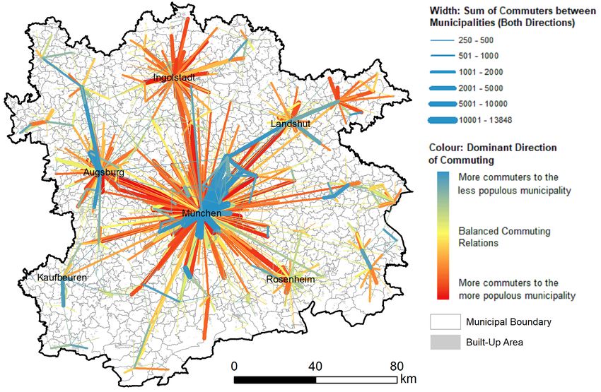
Urban Sci. 2020, 4, 2                                                                                7 of 24

3.3. Previous Studies on the Relationship of Transport and Land Use in the MMR
      Already the construction of the S-Bahn network had been monitored scientifically with respect to
its consequences for settlement patterns. The most important works by Kreibich [61] and Linder [56]
from the 1970s will be briefly summarised in the following (own translations). In his assessment of the
likely development effects of the S-Bahn, Linder [56] is very critical of the effects of mass transit on
patterns of land use and its capacity to reduce car traffic. He sees the S-Bahn as a structuring element
of development of region-at-large and an attempt by the (then fully public) German rail operator
Deutsche Bundesbahn (DB) to actively participate in the economic development and suburbanisation
of Munich (p. 55). He describes the implementation of the then new (first) trunk rail line as “dictate”
of segregation of employment, residential and recreational functions for the Munich region by DB,
with the aim of a “pyramid construction of large-sized segregated economic spaces” (p. 203) for the
sole purpose of economic growth for the region as a whole. Particularly, it encouraged economic
concentration through increasing accessibility and locational advantages in central locations, especially
when constructed radially (p. 198/203). The displacement of residential uses from the centre to the
periphery in favour of commercial uses means displacement of the least with the most traffic-intensive
use, creating unnecessary traffic that could be avoided with a closer allocation of spatial functions
(p. 195/203). The capacity constraint of transport infrastructure in central locations hence means a real
development barrier in the process of urban densification: Where disadvantages of growing congestion
offset the advantages of central locations, a growing economy is forced to divert to other centres or the
periphery, which might be more desirable in social terms (p. 196).
      This view is shared by Kreibich [61]. His analysis of the settlement effects six years after the
opening of the S-Bahn strikingly shows its catalysing effects on suburbanisation, with significantly
higher population growth rates in towns along the new suburban rail lines. At the same time, he argues
that firms are no longer required to operate branch offices in sub-centres, instead being able to service
a much wider area from the centre of Munich, reinforcing the monocentric structure of the region and
leading to displacement of 50,000 residents from central areas between 1961 and 1974 (p. 294). Like
Linder, Kreibich also criticizes the lack of tangential connections (p. 302). In being an instrument of
regional economic growth, with detrimental consequences for interregional disparities, the S-Bahn
“serves the continuing accumulation of capital in the centre of Munich and the preservation of the
capitalist system”.
      More recent comparable studies have been conducted by Schürmann and Spiekermann [62] for
the German Federal Institute for Research on Building, Urban Affairs and Spatial Development (BBSR)
and by Thierstein et al. [63].
      Schürmann and Spiekermann [62] analyse the effects of four transport infrastructure projects
(two rail and two road) in different German city-regions. For the MMR, they analyse the effects
of the A96 motorway extension west of Munich completed in 1996. They find that the share of
out-commuters to Munich along the corridor is highly correlated with the accessibility level of a
municipality within the region, and that there are strong relationships between the accessibility level
and the net migration of a municipality as well as the change rate of accessibility and migration surplus.
Regarding employment, they find that the relationship between accessibility level and employment
development is weakly negative but that improvements in accessibility are correlated with employment
growth (particularly for distance- and car-based accessibility indicators). Overall, they identify a strong
relation between accessibility levels, land values and urbanisation. Interestingly, their data also shows
that the establishment of the new Munich airport north-east of Munich in 1992 seems to have had even
stronger effects on employment and population in the respective surrounding municipalities than the
A96 corridor.
      A study of household, workplace and mobility choices in Munich by Thierstein et al. [63–65]
has highlighted the need for differentiation between population subgroups and their motivations
for residential and employment location choices. In a sub-project, Zhao et al. [64] demonstrate for
example that knowledge-workers show differing patterns of the use of space according to their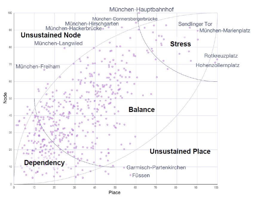
Urban Sci. 2020, 4, 2                                                                                    8 of 24

knowledge-base (as identified by Asheim [66]). While “analytic” knowledge workers—e.g., in the
domains of engineering—show a higher willingness to settle in a suburban setting and a preference
for car-oriented transportation, “synthetic” and “symbolic” knowledge workers, e.g., in the art and
cultural industries, show a stronger preference for urban locations and for active-mode transportation.
The study also underlines the need for a better jobs–housing balance in the municipalities of the region
as a strategy to reduce commuting distances, as well as an improvement of urban amenities in smaller
municipalities [65].
      Finally, the Swiss Federal Office for Spatial Development (ARE) [67] has studied the impacts of
the opening of the suburban rail network in Zurich 1990, which is comparable to Munich in terms of
its economic structure. The study likewise finds evidence for population growth in the area served
by the system but even stronger growth in some unaffected municipalities. In terms of employment,
areas that have not benefitted from a travel time decrease to the centre have suffered from losses,
as well as areas with a strong increase in accessibility in already good starting positions. No clear
overall tendencies could be observed. The study highlights the conjecture of three forces influencing
local population and employment growth, transport effects, (endogenous) potentials and actors, and
recommends stronger collaboration between municipalities, landowners and rail operators to activate
building potentials in proximity to stations.
      In sum, past studies on the effects of transport infrastructure improvements on settlement
structures in Munich tend to find strong relations to suburbanisation, the large-scale segregation
and concentration of urban functions and metropolisation but little indications for a connection to
re-urbanisation or a regional dispersion of economic activity. The effects seem to weaken with time.
The MMR seems, at least until now, as a whole, not to be characterised by the “disappearance of
traditional suburbia” or a “blurring of the boundary between urban and suburban” [1], nor have
major “outer cities” materialised in low-density suburbs that could rival the traditional urban cores.
The studies hint at the conclusion that the monocentric alignment of transport infrastructure, along
with other planning policies to protect the traditional urban cores could be responsible for this.

4. Materials and Methods
     The fourfold division of the paper is also reflected in the methods. To answer the first research
question, we analyse recent commuter data for the MMR between 2005 and 2018 by the German
Federal Employment Agency, using descriptive statistics. Commuter data is very useful to identify
concentration and de-concentration processes of households and employment, as it always encompasses
both residential and work locations [14].
     For the second research question, we use a gravitational accessibility model of population.
Gravitational accessibility is a measure to describe the cumulative “possibility of interaction” [68]
measured through the number of people (or jobs, amenities etc.) that can be reached from a certain
location, while more distant destinations in terms of travel time are weighted less than those in greater
proximity. We use an exponential distance decay function in the form of
                                                         X W [ j]
                                          Gravity[i] =                                                      (1)
                                                             eβ×d[i,j]
where Gravity [i] is the Gravity index at location i, W[j] is the weight of destination j, d[i,j] is the travel
time between locations i and j, and β is the exponent for adjusting the distance decay (see [69] for
a more detailed description). The gravitational approach has a long tradition in land use-transport
interaction modelling and accessibility analysis (e.g., [70,71]), as it is assumed to model interactions
and travel likelihood closely.
     The distance decay is calibrated using actual commuter data from the MMR for 2018. The share
of out-commuters to Munich on all out-commuters in a municipality halves after about 20 minutes
of public transport travel distance between the municipality and Munich, resulting in a decay factor
of 0.033 for the exponential function (R2 = 0.78), in line with a range of other studies of regional
Urban Sci. 2020, 4, 2                                                                                9 of 24

commuting relations (e.g., [72–74]). The model includes 512 rail stations and their interconnections
in the MMR. It encompasses not only the S-Bahn network, which so far covers only Munich and
its hinterland but not the regional centres, but also the regional train network that stretches across
the entire metropolitan region, and the underground network in Munich. The travel time data was
gathered manually from the travel information of Deutsche Bahn [75] for a Tuesday morning in the
timetable period of 2019 without construction works. The data for 2028, after the opening of the second
trunk line, was estimated based on the currently planned operational programme as published on the
official project website [76]. No new stations will be added through the project; the new express lines
will only serve—some—existing stations.
      Gravitational accessibility modelling has a number of potential weaknesses. To circumvent the
self-potential bias in cell-based gravitational accessibility analyses [77], we followed the method of [78]
and calculated the average weighted distances from 100 × 100 m population grid cells of the 2011
census [79] to the nearest station included in the model to correct for differing internal population
distributions. These population figures are then used as weights of the stations. A common challenge
of accessibility models is furthermore a negative bias towards the fringes, unless a buffer zone is
included. Hence, we added a buffer zone of 518 stations in a 2-hours travel time buffer around the
MMR. In Austria, however, only a 1 × 1 km population grid could be used to derive station weights.
The accessibility calculations were carried out for 2019 and 2028, and the results compared. No changes
in the distance decay parameter or the population distribution were assumed. An important constraint
of the model is that it does not reflect differences in service frequencies of the connections included
and that transfer times can only be modelled very crudely. For the model, a fixed threshold of 120
minutes as minimum frequency was chosen to determine whether a connection is included or not, and
transfer times were generally assumed to be two minutes, as public transport in the core areas of the
region is quite frequent. Here, agent-based modelling provides more realistic results on the level of
individual users of the system. Another important qualification must be made regarding the costs
used in this paper: It focuses on time-costs only, while monetary costs are important determinants of
public transport use as well. In the course of the “Zweite Stammstrecke” project, it is however mainly
the temporal aspect that will change. The new lines will be included in the existing transit tariff of
Munich. We hence refrained from including monetary costs in our analysis.
      For the third step, we gathered additional data on the functions around the 512 stations, namely
demographic, employment and land use data in a 700 m radius. Such 700 m radius is typically seen as a
distance that residents in urban and suburban settings on average are willing to walk to a higher-order
public transport stop like a train station [80]. Where these radiuses overlap, they were cut along
the equidistant line between the stations to avoid double-counting. In detail, we collected data for
three indicators, the population size, the number of firms, as well as the combined number of retail,
leisure and public facilities—henceforth called “facilities”. Firms and facilities data originate from
the company database Bisnode [81], which lists more than 400,000 firms for the MMR. Facilities were
identified according to the SIC classification included in the database (SIC codes 52 to 59 for retail,
78, 79 and 84 for leisure and 91 to 99 for public facilities). In a few cases, the values for shopping
and leisure facilities were manually adjusted to adequately represent mass attractors, such as football
stadia, large shopping centres and important sights.
      It is a basic principle of integrated urban and land use planning that the accessibility a public
transport station provides should be in balance with the density of functions around the station.
A station with high accessibility (frequent and fast connections to a lot of potential opportunities)
should not be surrounded by greenfields—this would be an inefficient use of the public transport
resources. Vice versa, dense urban areas should be served by highly accessible public transport stations
to avoid car-dependent settlement structures. Hence, planning should not allocate too many functions
to stations with low accessibility, or areas far away from public transport, and encourage development
around highly accessible but underused transport nodes. A basic conceptual model that describes
this relationship is the “node-place-model” by Bertolini [51] that suggests aiming for a balance of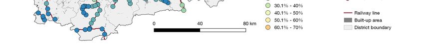
Urban Sci. 2020, 4, 2                                                                                 10 of 24

“node” (accessibility) and “place” (functional density) at each station. It allows visually to identify
“unsustained nodes” and “unsustained places” (stations with an accessibility surplus over the local
density of functions and vice versa), as well as “dependent” and “stressed” stations, that are balanced
but in danger of inefficiency or overcrowding. The model has been operationalised and tested in
various settings (e.g., [82,83]), and several additions have been proposed to derive more detailed
station typologies (e.g., [84]). For this paper, we assumed the accessibility values from the second step
as node values and the combined functional data (population size, firms and facilities) as place values.
      As a fourth step, to derive policy recommendations, we used the indicators and additional data to
construct six variables for a cluster analysis:

•     Functional Density (or “Place Value”, as described above).
•     Functional Surplus: The surplus or deficit of local functional density compared to accessibility.
•     Residential Surplus: The surplus or deficit of local population size compared to jobs and facilities.
•     Accessibility Change (2019–2028).
•     Densification Potential.
•     New Building Potential.

     The densification potential was calculated by determining the area within the 700 m radius around
the station that is classified as “built up” in the land use cadastre [85] and dividing it by the place value.
The variable hence describes the efficiency of the use of space, i.e., the space needed per point of place
value. We assumed as new building potential all areas classified as agricultural or forest, unless they
are protected.
     The data for all indicators except the new building potential were divided by their maxima and
transformed using a square root function to smooth out outliers. For the functional data, this was done
separately for population size, firms and facilities and later summed up. All indicators were then
normalised on a 1 to 100 scale. The variables were used for a K-means clustering approach to identify
groups of similar stations. A solution with seven clusters was chosen as appropriate solution.

5. Results and Discussion

5.1. Structure and Dynamics of Commuting Relationships in the MMR 2005–2018
     The first research question deals with the current structure and recent dynamics of commuter
relationships. Figure 2 shows the strongest commuting relationships between municipalities in the
MMR (250 and more commuters), Figure 3 shows the strongest changes of commuter relationships
between 2005 and 2018. No major infrastructure works have been completed during this phase.
Aggregate commuting has decreased between 13.5% of all pairs of municipalities, but in these cases
only in small absolute numbers. Figure 3 hence shows only relations where the aggregate number of
commuters has increased by more than 150.
Urban Sci. 2020, 4, 2 11 of 24
Urban Sci. 2020, 4, x FOR PEER REVIEW 11 of 25
Urban Sci. 2020, 4, x FOR PEER REVIEW 11 of 25
Figure 2. Strongest commuting relations in the MMR in 2018 (Source: own work, using geodata by
Figure 2. Strongest
Strongest commuting
commuting relations
relations in the MMR in 2018 (Source: own
own work,
work, using geodata
geodata by
Bayerische Vermessungsverwaltung, Bundesamt für Kartographie und Geodäsie, Bundesagentur für
Bayerische Vermessungsverwaltung, Bundesamt für Kartographie und Geodäsie, Bundesagentur für
Arbeit).
Arbeit).
Figure3.3.Dynamics
Dynamics of commuter relationships in the MMR between 2005 and 2018 (Source: own
Figure
Figure 3. Dynamicsofofcommuter
commuterrelationships in the
relationships MMR
in the between
MMR 20052005
between and 2018
and (Source: own work,
2018 (Source: own
work,geodata
using using geodata by Bayerische
by Bayerische Vermessungsverwaltung,
Vermessungsverwaltung, BundesamtBundesamt für Kartographie
für Kartographie und
und Geodäsie,
work, using geodata by Bayerische Vermessungsverwaltung, Bundesamt für Kartographie und
Geodäsie, Bundesagentur
Bundesagentur für Arbeit).für Arbeit).
Geodäsie, Bundesagentur für Arbeit).
Commuting relationships in the MMR still show a fairly classical pattern of core–periphery. The
Commuting relationships in the MMR still show a fairly classical pattern of core–periphery. The
city of Munich and, to a lesser degree, the regional centres of Augsburg and Ingolstadt are dominant
city of Munich and, to a lesser degree, the regional centres of Augsburg and Ingolstadt are dominant
centres of in-commuting, which shows the degree of metropolisation and suburbanisation in the
centres of in-commuting, which shows the degree of metropolisation and suburbanisation in theUrban Sci. 2020, 4, 2 12 of 24
Commuting relationships in the MMR still show a fairly classical pattern of core–periphery.
The city of Munich and, to a lesser degree, the regional centres of Augsburg and Ingolstadt are
dominant centres of in-commuting, which shows the degree of metropolisation and suburbanisation
in the region. However, some of the municipalities directly bordering on Munich, particularly to
the south and north-east, exhibit a commuter surplus from Munich. All these municipalities are
well-connected to Munich by rail-based public transport. These relations also show the strongest
dynamics during the last 14 years. The most remarkable change has occurred between Munich and
its neighbouring municipality Unterföhring to the north-east. The number of out-commuters from
Munich to Unterföhring has risen from 6948 to 11,300 in just 14 years, while the reverse direction is
only travelled by 2700 commuters a day (2005: 1703). This means that now the strongest commuter
flow in the MMR is no longer directed at Munich as in 2005, but away from Munich to one of its
suburban neighbours. The change is likely driven by a high number of media and insurance companies
located there that have exhibited strong job growth. The town is also located on the axis between
Munich and the airport, which is another job motor in the region. It seems however that employees
at firms in Unterföhring are not willing or able to relocate there and instead chose to commute from
Munich, despite slightly higher rental and real estate prices, which points to an increasing role of urban
amenities for employees in knowledge-intensive firms.
The weak position of Augsburg, the second largest city in the region, comes as a surprise: There
has been a strong increase in out-commuting to almost all neighbouring municipalities during the last
one and a half decades. Augsburg is now the number one commuter origin for Munich and could
functionally become a large suburb in the future, as there are no signs of a change in dynamics or
an increase of commuting in the reverse direction. Commuting between the other regional centres
and Munich has also strongly increased but in a more balanced way. Not included in the figure, but
likewise with above-average increases, are commuting relations between the regional centres in the
MMR and those of neighbouring regions, particularly between Munich and Ingolstadt, on the one
hand, and Nuremberg, on the other, confirming the findings of Pütz [14].
In total, Munich and Ingolstadt still gained new in-commuters from the fringes of their commuter
zones, while the commuting relationships with some of their immediately surrounding municipalities
are increasingly characterised by a reverse commuting, while overall commuting distances continued
to rise. This is in line with previous literature for the Munich case [41,86]. It is thus fair to still speak of
a rather monocentrically organised region, with signs of polycentricism immediately around the major
regional centres. However, there are two main restrictions to this argumentation: First, the latter can
be interpreted as a phenomenon not entirely different from the past, just an upscaling—polycentric
development, albeit weak, has happened within the city-limits before (e.g., [87]), and only now that
it exceeds the administrative boundaries, it is also visible in the commuter data. Second, and more
importantly, tangential commuting relations still play almost no role in the MMR. Among the top
commuting relations, there is none that is not directed either to or from one of the major centres
Munich, Augsburg and Ingolstadt. These are also still the commuting relations with the strongest
growth. Only the 144th relation (Erding–Freising, 1100 commuters) is tangential. This is likely caused
by the airport, which is located on the border between the two municipalities and shows its capability
to act as nucleus for economic activity.
Regarding our first research question, we conclude that, indeed, commuter relations suggest a
growing role of out-commuting from the major centres of the region to municipalities in the vicinity
and therewith highly urban and central residential locations combined with suburban employment
(re-urbanisation and regionalisation). However, the majority of commuting relations still conform to
the traditional regional core–periphery dichotomy. In addition, the new employment centres in the
surroundings of Munich, Augsburg and Ingolstadt have so far not been able to attract substantial
tangential commuting relations from their other neighbours, which might be due to the monocentric
structure of the public transport system.Urban Sci. 2020, 4, 2 13 of 24
5.2. Rail-Based Public Transport Accessibility and Accessibility Changes through the Second Trunk Line
Figure 4 shows the clear accessibility gradient by rail-based public transport in the MMR. The most
accessible station is expectably Munich main station, from where travel times to most other destinations
are shortest (set as 100%). The first 48 of 512 stations in terms of accessibility are located in Munich
Urban Sci. 2020, 4, x FOR PEER REVIEW 13 of 25
proper, among them all stations along the first S-Bahn trunk line. Despite the inclusion of a large buffer
azone,
largethe stations
buffer tothe
zone, the stations
south, close to south,
to the the Alps andto
close the Austrian
the Alps and border, show theborder,
the Austrian lowest show
accessibility
the
values, also because often they are located in “dead-ends” of lines. The regional centres
lowest accessibility values, also because often they are located in “dead-ends” of lines. The regional Augsburg,
Ingolstadt,
centres Landshut
Augsburg, and Rosenheim
Ingolstadt, Landshut clearly exhibit smaller
and Rosenheim clearly accessibility maxima,
exhibit smaller but these
accessibility do not
maxima,
come close to the values that even suburban stations around Munich show.
but these do not come close to the values that even suburban stations around Munich show.
Figure
Figure4.4.Accessibility
Accessibilityof
ofpopulation
population with public transport
with rail-based public transportatatrailway
railwaystations
stationsininthe
the MMR
MMR 2019
2019 (Munich
(Munich main = station
main station = 100%)
100%) (Source: own(Source: own
work, using work,
geodata using geodata
by Bayerische by Bayerische
Vermessungsverwaltung,
Vermessungsverwaltung,
Bundesamt für Kartographie Bundesamt für Kartographie
und Geodäsie, Deutsche und
Bahn).Geodäsie, Deutsche Bahn).
Figure55shows
Figure showsthe theincreases
increasesiningravitational
gravitational accessibility
accessibility induced
induced bybythethe construction
construction of second
of second
trunk line. The
trunk Theeast–west
east–west orientation
orientation of the
of new
the infrastructure means means
new infrastructure that improvements of accessibility
that improvements of
are foremostare
accessibility located in these
foremost sectors
located around
in these the city.
sectors The stations
around the city.inThethestations
south ofinthe region
the southwill profit
of the
relatively
region willlittle, even
profit though they
relatively little,areeven
currently
though already
they characterised
are currentlyby low absolute
already accessibility
characterised levels.
by low
absolute accessibility
Nevertheless, levels.
it can be seenNevertheless,
that all stations it can be seen
in the that
region all stations
profit from aninincrease
the region profit from an
of accessibility of at
increase
least 22%,of even
accessibility
where there of atwill
leastbe22%, evenlines
no direct where there
using thewill
newbeinfrastructure,
no direct lines due using the new
to trickle-down
infrastructure,
effects throughout due the
to trickle-down
region. Munich effects
mainthroughout thethe
station is still region.
point Munich main accessibility,
of the highest station is still theit is
and
point
among of the
the stations
highest with
accessibility,
the highest andabsolute
it is among the stations
accessibility with the
increases, highest
which showsabsolute accessibility
the reinforcing effect
increases, which
of the second shows
trunk linetheonreinforcing
the monocentric effect of the second
regional trunkand
structure lineconfirms
on the monocentric regional
our hypothesis. Other
structure and confirms
stations along the second ourtrunk
hypothesis.
line canOther stations along
also strongly improve the their
second trunk
rank line can also strongly
position.
improve their rank
However, position.
in relative terms, suburban stations along four corridors to the west, north and east of
the city are to gain most, albeit from a low previous level. Some of the municipalities to the west of
Munich, currently showing a strong commuter-deficit, will experience a doubling of their accessibility,
higher than some peripheral parts of the city of Munich proper. The strongest accessibility gain was
determined for the small town of Weßling, the designated first stop of a planned express line beyond
the city centre.Urban Sci. 2020, 4, 2 14 of 24
Urban Sci. 2020, 4, x FOR PEER REVIEW 14 of 25
Change
Figure5.5.Change
Figure of of accessibility
accessibility of population
of population with
with rail-based
rail-based public
public transport
transport at railway
at railway stations
stations in
in MMR
the the MMR 2019–2028
2019–2028 (Source:
(Source: ownown work,
work, using
using geodata
geodata byby BayerischeVermessungsverwaltung,
Bayerische Vermessungsverwaltung,
Bundesamtfür
Bundesamt fürKartographie
Kartographieund undGeodäsie,
Geodäsie,Deutsche
DeutscheBahn).
Bahn).
The analysis
However, showsterms,
in relative that the strongest
suburban effectsalong
stations are highly selectivetoand
four corridors the affect
west, only
northsome sectors
and east of
of city
the the public transport
are to gain most,network. Thea effects
albeit from dependlevel.
low previous highly on the
Some scheduled
of the services.
municipalities toItthe
also shows
west of
that the effects
Munich, currentlyquickly attenuate
showing with distance,
a strong assuming a commuting-related
commuter-deficit, will experience a distance doublingdecay factor.
of their
accessibility, higher than some peripheral parts of the city of Munich proper. The strongestas
Still, some smaller regional centres that were so far in greater relational distance to Munich, such
Kaufering, Buchloe
accessibility gain wasand Mering tofor
determined thethe
west of Munich,
small town ofwill receivethe
Weßling, a direct connection
designated first to theofvery
stop a
centre of the city and partially fall
planned express line beyond the city centre. below the critical commuting time threshold of slightly more than
halfThean hour.
analysisMethodologically, the analysis
shows that the strongest shows
effects the merit
are highly of gravitational
selective and affect only accessibility
some sectorsanalysis
of
for visualisations.
the public transport network. The effects depend highly on the scheduled services. It also shows that
As accessibility
the effects and land
quickly attenuate values
with are strongly
distance, assuming related, the map can alsodistance
a commuting-related be readdecay
as a projection—or
factor. Still,
at least
some a spatial
smaller perspective—of
regional centres thatlikely
weredemand
so far in changes
greateronrelational
the land market.
distanceBased on the such
to Munich, previousas
experiences in the region as described in the literature review and the
Kaufering, Buchloe and Mering to the west of Munich, will receive a direct connection to the veryresults of chapter 3.1, it can
be assumed that particularly the west of Munich will undergo another wave
centre of the city and partially fall below the critical commuting time threshold of slightly more thanof suburbanisation that
willanintensify
half the pressure in the
hour. Methodologically, theexisting
analysiscommuter
shows thebelt meritandof extend it further
gravitational westwards
accessibility to include
analysis for
the smaller
visualisations. regional centres there. At the same time, the monocentric alignment of the second trunk
lineAsmeans that it will
accessibility andincrease the potential
land values customer
are strongly related,andtheemployee
map can also basebe ofread
firmsasina highly central
projection—
orlocations, contributing
at least a spatial to further likely
perspective—of segregation
demand of changes
functions onand
thean extension
land market. of the commercial
Based on the previous zone
in Munich.
experiences in the region as described in the literature review and the results of chapter 3.1, it can be
assumed However, planningthe
that particularly canwest
andofshould
Munich setwill
theundergo
framework for this
another wave development and trythat
of suburbanisation to will
work
towards greater regionalisation of economic activity. In the following chapter,
intensify the pressure in the existing commuter belt and extend it further westwards to include the we develop a station
typology
smaller with policy
regional centres recommendations,
there. At the same which
time,nottheonly includes alignment
monocentric accessibility ofbut
thealso localtrunk
second potentials
line
and small-scale
means that it will mix of uses.the potential customer and employee base of firms in highly central
increase
locations, contributing to further segregation of functions and an extension of the commercial zone
5.3. Comparison of Accessibility Levels and Functional Density around Railway Stations in the MMR
in Munich.
Figure 6 compares
However, the and
planning can accessibility (“Node”)
should set and combined
the framework for thisfunctional
developmentdensity
andoftrypopulation;
to work
firms; and
towards public,
greater leisure and of
regionalisation shopping
economic facilities
activity.(“Place”) for all 512
In the following rail stations
chapter, in thea MMR
we develop stationin
2018. It with
typology shows that recommendations,
policy there is a broad butwhich
significant
not onlyrelationship between node
includes accessibility but and values (R2
placepotentials
also local
= 0.41),
and and a mix
small-scale highofnumber
uses. of stations can be classified as “balanced” (termed “accessible” in the
stricter sense by Bertolini [51]). This means that the larger the number of people that can reach a
5.3. Comparison of Accessibility Levels and Functional Density around Railway Stations in the MMRYou can also read