Climate Action and Community Liveability Advisory Committee
←
→
Page content transcription
If your browser does not render page correctly, please read the page content below
Climate Action and
Community Liveability
Advisory Committee
Regular Agenda
Wednesday, May 19, 2021 – 7:00 pm
Zoom Videoconference
APPROVAL OF REGULAR MEETING AGENDA – May 19, 2021
APPROVAL OF MINUTES – March 10, 2021
A. DELEGATIONS/PRESENTATIONS
A.01 Translink: Where We’ve Been & Where We Are Going – TOGETHER
Delegation: Dave Lewin, Senior Advisor Public Affairs, TransLink
Fay Kramer, Senior Advisor Public Affairs, TransLink
Alex Anderson, Ridership Development, TransLink
Karen Halex, TravelSmart Specialist, Translink
A.02 Winskill Park Urban Forest Regeneration
Delegation: Todd Stewardson, Deputy Director of Parks, Recreation and
Culture
Reference Materials:
o Presentation, Winskill Park Urban Forest Regeneration (On Table)
B. BUSINESS ARISING FROM MINUTES
B.01 Electric Vehicles, Update from Manager of Climate Action and Environment
Reference Materials:
o Electric Vehicle Registration Data
o www.evcondo.ca (Metro Vancouver)
B.02 Dogs Off-Leash in Creeks and Upcoming Consultation on Delta Nature
Reserve and Delta South Surrey Greenway Management Plan, Update
from Manager of Climate Action and Environment
Reference Materials:
o Report from Metro Vancouver dated March 16, 2021 regarding
Delta Nature Reserve and Delta South Surrey Greenway – Public
Engagement and Management Plan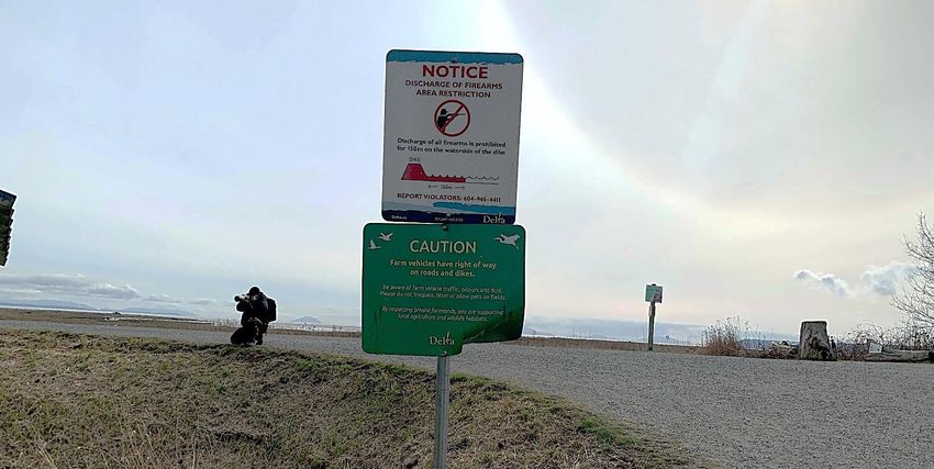
C. NEW BUSINESS
No items for this meeting
D. INFORMATION ITEMS
D.01 2021 Action List
Reference Materials:
o 2021 Draft Action List
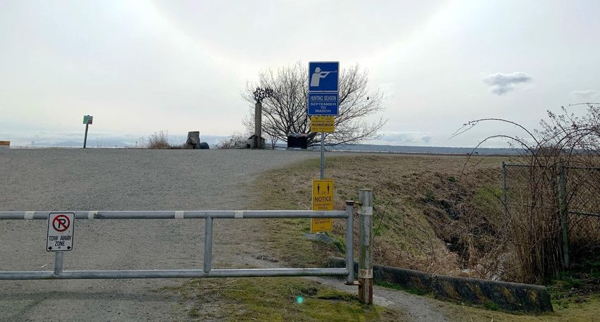
D.02 Hunting Signage at 72 Street Dike Access
Reference Materials:
o Memorandum from Rachael Ward, Planner dated March 9, 2021
regarding Hunting Signage at 72 Street Dike Access
D.03 Off-Leash Dogs in the Foreshore Areas of Mud Bay
Reference Materials:
o Memorandum to Council dated April 28, 2021 regarding Off-Leash
Dogs in the Foreshore Areas of Mud Bay
TERMINATION
Next Meeting Date: July 21, 2021
Climate and Community Liveability Advisory Committee
May 19, 2021
Page 2 of 2
Climate Action and
Community Liveability
Advisory Committee
Regular Minutes
Minutes of the Meeting of the Climate and Community Liveability Advisory Committee held
Wednesday, March 10, 2021 at 7:00 p.m. via Zoom Videoconferencing.
Present: Cllr. Dylan Kruger, Chair
Cllr. Alicia Guichon, Vice-Chair
Ali Bajwa
Brian Kirkbride
Herb Klassen
Deborah Jones
Jill McKnight
John Mancini (arrived at 8:10 p.m.)
Jeremy Stam
Also Present: Mel Cheesman, Director of Corporate Services
Mike Brotherston, Manager of Climate Action & Environment
Sarah Howie, Environmental Research Analyst
Leeann Graham, Environmental Officer
City Clerk’s Crystal Sanca, Committee Clerk
Cllr. Kruger, Chair, called the meeting to order at 7:01 p.m.
APPROVAL OF REGULAR MEETING AGENDA – March 10, 2021
MOVED By Jeremy Stam,
SECONDED By Brian Kirkbride, THAT the agenda for March 10, 2021 be received
and adopted as presented.
CARRIED UNANIMOUSLY
APPROVAL OF MINUTES – January 20, 2021
MOVED By Deborah Jones,
SECONDED By Jeremy Stam, THAT the minutes for the January 20, 2021
meeting be received and adopted as circulated.
CARRIED UNANIMOUSLY
Minutes of the Climate Action and Community Liveability Advisory Committee Meeting
March 10, 2021
Page 1 of 9
A. DELEGATIONS/PRESENTATIONS
  A.01 Electric Vehicle Strategy Implementation Update
        Delegation: Presentation by Mike Brotherston, Manager of
                    Climate Action & Environment
        Reference Materials:
           o PowerPoint presentation               titled    “Electric     Vehicle       Strategy
             Implementation Update”

        M. Brotherston reviewed the PowerPoint presentation (On File) providing
        an overview of Delta’s goals, actions and next steps in the Electric Vehicle
        Strategy Implementation.
        During the presentation, M. Brotherston confirmed that Delta now has 10
        public electric vehicle (EV) charging stations throughout the City and noted
        that in 2018 there were zero. Twenty more public charging stations will be
        installed this year, partly funded by a Federal grant. Staff have seen a
        steady increase in use of EV charging stations; some locations are more
        utilized than other stations. Currently Delta’s EV charging stations are
        programmed to automatically turn off after 2 hours of charging to encourage
        turnover and make the stations available to other users. Several other
        municipalities in the region are charging fees for use of EV charging
        stations. Staff will bring forward a similar fee structure to Council for
        consideration ($1-$2/hour). The actual cost to Delta for electricity used at
        the stations is approximately $0.50/hour, but there are also other costs
        associated with operating the stations.
        M. Brotherston noted that the Province of British Columbia passed the
        Zero-Emission Vehicles Act on May 30, 2019, which requires that sales and
        leases of light-duty vehicles must meet an escalating annual percentage of
        zero-emission vehicles reaching 100% by 2040.
        In response to Committee queries, M. Brotherston noted the following:
           •   Although BC Hydro’s EV Charger Rebate Program closed on
               February 28, 2021, staff continue to lobby for more sustained
               programs and incentives, and anticipate that new Provincial or
               Federal incentives are expected to come forward.
           •   Currently Delta’s Zoning Bylaw requires 20% of new residential
               parking spaces in multi-family buildings to be EV-ready. In
               accordance with the actions in Delta’s EV Strategy staff are
               preparing a Council report on proposed amendments to the Zoning
               Bylaw to propose that up to 100% of parking stalls in new multi-family
               buildings provide an energized electrical outlet capable of providing
               Level 2 or higher electric charging. The actual EV supply equipment
               for the charging stations will not be mandatory.

                  Minutes of the Climate Action and Community Liveability Advisory Committee Meeting
                                                                                      March 10, 2021
                                                                                         Page 2 of 9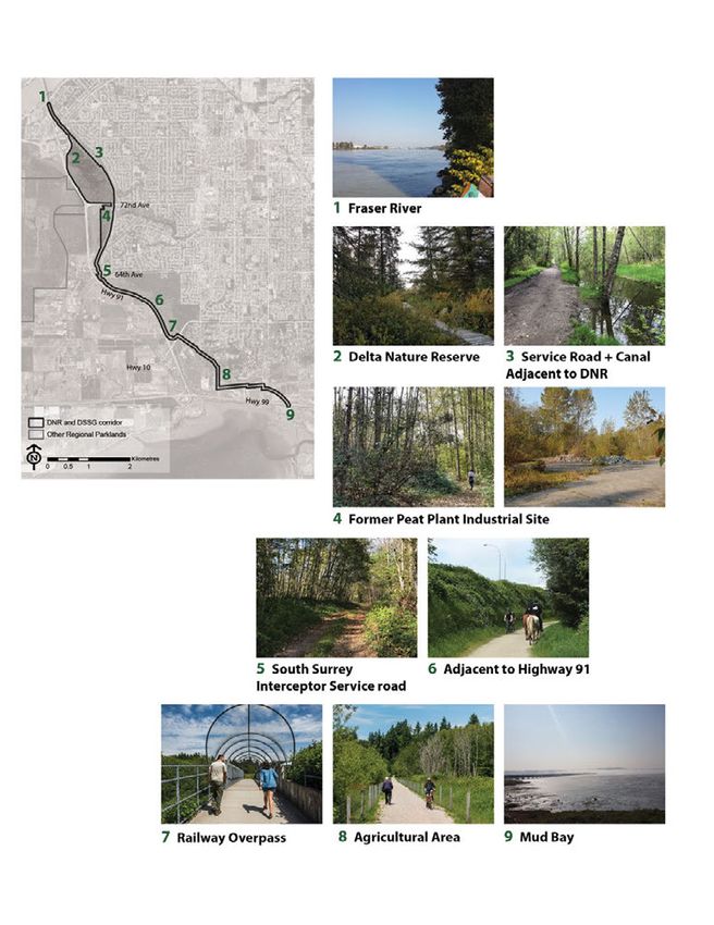
•   Due to the number of circuits and the amount of power, staff are
             looking to other municipalities for best practices to allow power
             sharing for triggering offsite electrical improvements, which could
             make it more economical on a building scale. Staff will provide the
             Committee with the proposed amendments for information, prior to
             Council consideration.
         •   Staff will report back with the number of electric vehicles registered
             in Delta, and how the numbers relate to other municipalities.
         •   It does not appear that EV charging stations present a fire hazard,
             Level 2 charging stations charge at 240V, 30A power. Direct current
             (DC) fast charging stations charge at a power of 480V. The latter are
             intended for use by vehicles traveling longer driving distances and
             are typically located at rest stops and other locations near major
             travel corridors.
         •   Staff will report back with information regarding Metro Vancouver’s
             EV Condo Pilot Program through Metro Vancouver’s Innovations
             fund.
         •   Solar power opportunities were discussed. It was noted that 8% of
             Germany’s gross power is through solar powered homes.
         •   Delta’s Solar Hot Water Ready Regulation requires all new single-
             family residential dwellings be constructed to accommodate the
             future installation of a solar hot water heating system for water
             heating.

      MOVED By Jeremy Stam,
      SECONDED By Brian Kirkbride, THAT the presentation be received for
      information.
                                                               CARRIED UNANIMOUSLY

A.02 Urban Forest Strategy Update
      Delegation: Presentation by Sarah Howie, Environmental
                  Research Analyst
      Reference Materials:
         o PowerPoint presentation titled “Urban Forest Strategy Update”

      S. Howie reviewed the PowerPoint presentation (On File) providing an
      update of the Urban Forest Strategy Update.
      S. Howie noted that the updated assessment of Delta’s urban canopy
      coverage by Dr. David Nowak of the US Forest Service will be completed
      in April 2021. S. Howie thanked committee member Deborah Jones for
      providing staff with several location suggestions for tree planting in Delta.

                Minutes of the Climate Action and Community Liveability Advisory Committee Meeting
                                                                                    March 10, 2021
                                                                                       Page 3 of 9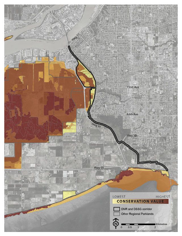
Committee members discussed the following:
         •   The importance of selecting the appropriate tree species for the
             planting location was discussed. S. Howie advised that any
             maintenance and pruning required would be completed by Urban
             Forestry staff to ensure that the trees are maintained properly. Trees
             requested by homeowners under the “Trees for Tomorrow” program
             are planted on the boulevard and watered by homeowners for three
             years to establish the tree. One of the action items in the Urban
             Forest Strategy is to ensure that staff resources are able to keep up
             to the needs of the urban forest.
         •   There has not been a strong uptake of the “Trees for Tomorrow”
             program, possibly due to lack of awareness. Staff will continue to
             promote the program to bring more awareness to the public.
         •   Staff will be exploring options for planting trees on private property
             through tree bylaw changes and tree replacement.
         •   Staff will report back to the Committee with the revisions to the
             bylaws for information, prior to Council consideration.
         •   Staff are working towards a goal of 40% tree canopy cover in all three
             communities in Delta, which is a common goal for urban areas. The
             most recent analysis from 2016 shows North Delta having 31.5% tree
             canopy cover, which includes Watershed Park but not Burns Bog or
             the Delta Nature Reserve. Ladner has 19.4% tree canopy cover and
             Tsawwassen has 25.2% cover.
         •   Committee members suggested replanting trees within the same
             neighbourhood from which they were removed.
         •   Introducing an incentive such as lower storm water fees to reward
             residents who have more tree canopy within their property was
             suggested. Staff explained that the administrative and technical
             challenges faced at this time to accommodate these incentives are
             more significant than beneficial.

      MOVED By Deborah Jones,
      SECONDED By Jill McKnight, THAT the presentation be received for
      information.
                                                               CARRIED UNANIMOUSLY

A.03 Birds and Biodiversity Strategy Update
      Delegation: Presentation by Leeann Graham, Environmental
                  Officer
      Reference Materials:
         o PowerPoint presentation titled “Birds and Biodiversity Strategy
           Update”

                Minutes of the Climate Action and Community Liveability Advisory Committee Meeting
                                                                                    March 10, 2021
                                                                                       Page 4 of 9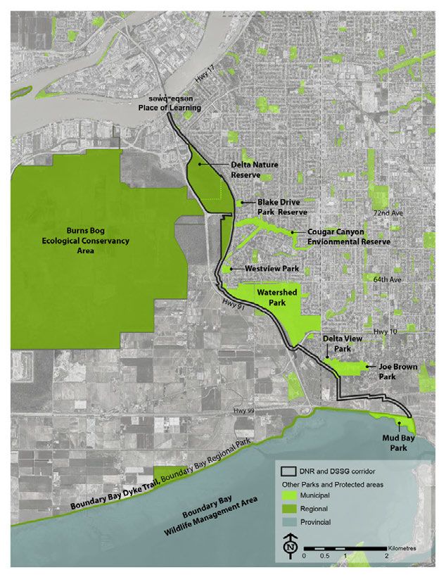
L. Graham reviewed the PowerPoint presentation (On File) providing an
   overview of the vision, mission, goals and objectives, overview of strategies,
   and next steps of the strategy.
   L. Graham advised that in order to uphold the certification of a Bat-friendly
   Community, Delta must conserve, protect and enhance bat habitat. To
   maintain Delta’s declaration as a Bee City, Delta must expand and increase
   the pollinator habitat within the City. A significant component for Bat-friendly
   Community certification and declaration as a Bee City, the City must
   continue to increase public awareness and engagement. Bat Week is held
   at the end of October and International Pollinator Week is held the third
   week of June. It was suggested to engage the Ladner Business Association
   to help bring their members and the community together in support of these
   campaigns.
   L. Graham commented on the recent collaboration with Surrey to begin
   participation in The Living Dikes Pilot Study, a nature-based coastal
   adaptation project to provide flood protection and offset habitat loss in the
   salt marsh area. This study will feature one pilot site in Delta and one in
   Surrey.
   Delta will be installing a second MOTUS wildlife tracking station at the 12th
   Avenue Pump Station, which will track and share the data on birds coming
   into Delta with a global collaborative network.
   L. Graham advised the theme for this year’s Earth Day Photo Contest is
   Gardens for Nature which will run from April 1 – 30, 2021.
   In response to Committee queries, L. Graham and M. Brotherston noted the
   following:
      •   Through legislation, all birds are protected, by protecting habitat you
          are protecting all birds. Staff will consult with experts regarding the
          possibility of prioritizing the protection of key species. Delta
          collaborates with groups such as Delta Farmland & Wildlife Trust,
          conservation organizations, specific researchers, Environment
          Canada, landowners and farmers to seek advice on appropriate
          management.
      •   A pollinator demonstration garden of native and ornamental species
          will be placed outside City Hall and will feature an interpretive sign.

John Mancini joined the meeting at 8:09 p.m.
   Committee members discussed the following:
      •   Delta Farmland & Wildlife Trust is a collaboration between
          conservationists and farmers, who have implemented grassland set-
          asides and winter cover crops in an effort to protect agricultural land.
          There has been a large influx of birds in the winter months coming
          into Delta.

             Minutes of the Climate Action and Community Liveability Advisory Committee Meeting
                                                                                 March 10, 2021
                                                                                    Page 5 of 9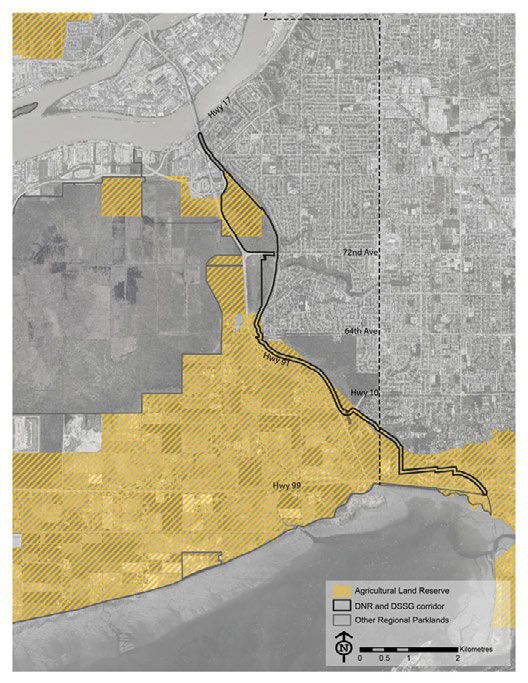
•   There could be opportunities to collaborate with the Agricultural
                Advisory Committee and the Delta Famers Institute to find
                connections with local farmers who may be able to contribute to the
                Barn Owl box project.
            •   The Birdslovedelta.ca campaign includes bus shelter posters of
                artwork, which bring awareness to bird species found in Delta. This
                campaign could be connected with the Community Resilience and
                Economic Support Team’s “We Love Delta” campaign to sell
                merchandise such as t-shirts and prints of birds to the public for
                potential fundraising. With an increase of hyper-local tourism, there
                could be an opportunity for an education component to post bird
                signage at popular farms visited by the public.
            •   It was suggested to incorporate Delta’s “Bird Love Delta” bird posters
                as permanent sign fixtures at the Delta Chamber of Commerce and
                at Delta parks.
            •   Walking tours and showcasing educational displays at the Delta
                Civic Center could help promote Delta’s Environmental campaigns.

        MOVED By Jill McKnight,
        SECONDED By Brian Kirkbride, THAT the presentation be received for
        information.
                                                                  CARRIED UNANIMOUSLY

B. BUSINESS ARISING FROM MINUTES
  No items for this meeting.

C. NEW BUSINESS
  No items for this meeting.

D. INFORMATION ITEMS

  BY CONSENT

  D.01 2021 Action List
        Reference Materials:
           o 2021 Action List
  D.02 Final Adoption of Official Community Plan (OCP) Greenhouse Gas Targets
        Reference Materials:
           o Memorandum from Marcy Sangret, Director of Community Planning
              & Development/Deputy City Manager, dated February 8, 2021
              regarding the Final Consideration and Adoption of Bylaw No. 7978
              for GHG Emission Reduction Target and Housekeeping.

                   Minutes of the Climate Action and Community Liveability Advisory Committee Meeting
                                                                                       March 10, 2021
                                                                                          Page 6 of 9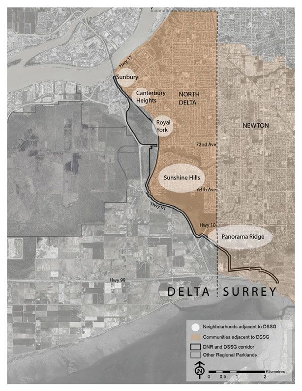
D.03 Update on Port Issues in Delta
       This item was removed from consent for discussion purposes. See page 7.

D.04 November 2020 Vancouver Landfill Technical Liaison Committee Meeting
       Reference Materials:
          o Memorandum from Mel Cheesman, Director of Corporate Services
            dated February 17, 2021 regarding the November 2020 Vancouver
            Landfill Technical Liaison Committee meeting.

D.05 FortisBC Energy Specialist
       Reference Materials:
          o Council Report from the Corporate Services Department dated
            January 12, 2021 regarding the FortisBC Senior Energy Specialist
            Agreement.

D.06 Letter from Mayor Harvie to the Minister of Forests, Lands, Natural
     Resource Operations and Rural Development (FLNRORD) regarding the
     Management of Brunswick Point Natural Area
       This item was removed from consent for discussion purposes. See page 8.

       MOVED By Jeremy Stam,
       SECONDED By Jill McKnight, THAT Items D.01 – D.02, and Items
       D.04 - D.05 be received for information.
                                                                CARRIED UNANIMOUSLY

INFORMATION ITEMS

FOR DISCUSSION

Cllr. Kruger declared a conflict of interest with respect to Item D.03 as his firm is
involved with the Vancouver Fraser Port Authority and recused himself from the
meeting at 8:32 p.m. prior to any discussion on this item.

D.03 Update on Port Issues in Delta
       Reference Materials:
          o Council Report from the Corporate Services Department dated
             February 3, 2021 regarding an update on Port Issues in Delta.

                 Minutes of the Climate Action and Community Liveability Advisory Committee Meeting
                                                                                     March 10, 2021
                                                                                        Page 7 of 9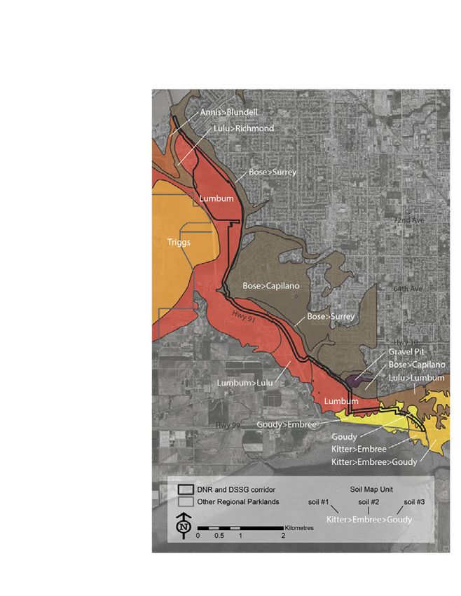
Committee members discussed the concerns regarding the proposed
      construction of a rock containment berm filled with sediment dredged from
      Canoe Pass. The negative effects on salinity, the possible loss of habitat,
      and potential flooding due to the redirecting of the channel were discussed.

      Cllr. Guichon advised that these concerns have been raised at meetings of
      the Agricultural Advisory Committee with strong opposition against the
      proposal. This project may also impede with Delta’s plans to establish a
      piped irrigation water supply to Westham Island.

      Ms. Cheesman advised that staff have recently addressed the concerns
      raised by farmers and Delta’s Engineering Department with Deltaport, and
      will continue to investigate these potential problems and how to address
      them. Staff will report back to Council with a fulsome report.

      MOVED By Herb Klassen,
      SECONDED By Deborah Jones, THAT Information Item D.03 be received
      for information.

                                                               CARRIED UNANIMOUSLY

Councillor Kruger rejoined the meeting at 8:40 p.m.

D.06 Letter from Mayor Harvie to the Minister of Forests, Lands, Natural
     Resource Operations and Rural Development (FLNRORD) regarding the
     Management of Brunswick Point Natural Area
      Reference Materials:
          o Letter from Mayor Harvie, dated January 22, 2021 regarding the
            Management of Brunswick Point Natural Area.

      In response to a Committee query, M. Brotherston noted that
          • Delta has not yet received a formal response from the Minister of
             FLNRORD, but Delta will be meeting with ministry staff and Metro
             Vancouver staff to discuss coordinated signage.
          • Hunters do not have special rights to enter into the marsh area; they
             must adhere to the Provincial rules.

      Committee members discussed the following:
        • It is common to see off leash dogs disturbing the marsh areas of
          Brunswick Point. There have been bylaw officers ticketing owners of
          off-leash dogs in non-off leash designated areas along the Boundary
          Bay Dike.
        • Committee members were in support of the letter addressing the
          need for improved signage, and ongoing education to the users of
          the municipal dike and surrounding areas.

                Minutes of the Climate Action and Community Liveability Advisory Committee Meeting
                                                                                    March 10, 2021
                                                                                       Page 8 of 9
• Brunswick Point would be an ideal location to display educational
bird signage.
• Concerns regarding poaching and off leash dogs disturbing salmon
nests along Lower Cougar Creek were discussed. Due to partnership
of the area between Delta and Metro Vancouver, and with Metro
Vancouver taking over the park, there is reluctance for new Delta
signage in the area. Metro Vancouver is in the early stages of
completing a Public Consultation on developing the Greenway Park;
this consultation will provide the public with the opportunity to voice
their comments. Staff will address these concerns to Metro
Vancouver staff in the interim.
MOVED By Brian Kirkbride,
SECONDED By Deborah Jones, THAT Information Item D.06 be received
for information.
CARRIED UNANIMOUSLY
Next Meeting Date: May 19, 2021
TERMINATION
MOVED By Brian Kirkbride,
SECONDED By Herb Klassen, THAT there being no further business, the
meeting now terminate.
CARRIED UNANIMOUSLY
The meeting terminated at 8:53 p.m.
___________________________________
Cllr. Dylan Kruger, Chair
CERTIFIED CORRECT:
___________________________________
Crystal Sanca,
Committee Clerk
Minutes of the Climate Action and Community Liveability Advisory Committee Meeting
March 10, 2021
Page 9 of 9Metro Vancouver EV Registrations (ICBC data) B.01 Municipality 2015 2016 2017 2018 2019 Vancouver 571 896 1,420 2,543 4,878 Surrey 290 485 781 1,440 3,171 Richmond 174 264 487 902 1,835 Burnaby 156 238 427 829 1,701 North Vancouver 193 318 521 922 1,681 Coquitlam 107 183 354 632 1,306 Langley 99 176 315 558 1,112 West Vancouver 178 280 412 619 918 Delta 63 114 230 427 835 Maple Ridge 67 103 183 321 625 Port Coquitlam 45 74 142 253 514 New Westminster 37 66 107 201 395 Port Moody 29 43 105 205 382 White Rock 24 36 58 110 174 Pitt Meadows 8 16 39 72 145 UBC 30 43 58 79 133 Lions Bay 11 17 22 38 60 Bowen Island 7 12 14 31 58 Anmore 3 9 10 26 43 Belcarra 3 6 9 14 22
B.02

To:            Regional Parks Committee

From:          Steve Schaffrick, Division Manager, Central Area, Regional Parks

Date:          March 16, 2021                                          Meeting Date: April 7, 2021

Subject:       Delta Nature Reserve and Delta South Surrey Greenway – Public Engagement and
               Management Plan

RECOMMENDATION
That the MVRD Board authorize staff to proceed with the engagement process as presented in the
report dated March 16, 2021, titled “Delta Nature Reserve and Delta South Surrey Greenway – Public
Engagement and Management Plan”.

EXECUTIVE SUMMARY
This report seeks approval to proceed with the engagement process for the development of a
management plan for the Delta Nature Reserve and Delta South Surrey Greenway. In 2020, Regional
Parks received fifty percent ownership and assumed operational responsibilities of the Delta Nature
Reserve from the City of Delta.

The Delta Nature Reserve, along with lands in the Burns Bog Ecological Conservancy Area east of
Highway 91, presents opportunities for ecosystem enhancement and expanded parks visitor facilities.
The envisioned extension of the Delta South Surrey Greenway runs along the eastern boundary of
these park lands. Planning for the park lands and greenway together will ensure a cohesive and
rationalized management plan to guide park development, resource management and decision
making.

If approved, the management plan process will start with a first phase of public, First Nations, and
stakeholder engagement to inform the management plan.

PURPOSE
To provide the Regional Parks Committee and MVRD Board with background information that
contributes to the preparation of a management plan for the Delta Nature Reserve (DNR), Burns Bog
Ecological Conservancy Area (BBECA) lands east of Highway 91 and the Delta South Surrey Greenway
(DSSG), and to receive authorization to begin phase 1 engagement for the plan.

BACKGROUND
The Metro Vancouver Board Strategic Plan 2019 to 2022 directs the Regional Parks Service to develop
individual park plans that provide public access to parks, and protect important ecosystems and
habitats. When the City of Delta transferred a 50% ownership of the DNR to Metro Vancouver in
2020, staff committed to bring forward a subsequent report seeking MVRD Board authorization to
initiate public and stakeholder engagement toward the management plan. This work was also
identified on the 2021 Regional Parks Committee Work Plan.

44150026
Delta Nature Reserve and Delta South Surrey Greenway – Public Engagement and Management Plan
Regional Parks Committee Regular Meeting Date: April 7, 2021
Page 2 of 4
DELTA NATURE RESERVE AND DELTA SOUTH SURREY GREENWAY
Metro Vancouver began operating the DNR as part of the BBECA in November 2020. The DNR
currently provides approximately 2 kilometres of boardwalks through bog and mature forest
ecosystems. At the moment, the DNR is the only publicly accessible part of Burns Bog. The planning
process will also consider opportunities for park staging and amenities, along with habitat
enhancement in the additional lands within the BBECA east of Highway 91.
The Regional Greenways 2050 plan identified routing of the DSSG along the eastern boundary of the
BBECA, as part of a route between Mud Bay Park in Surrey and the Fraser River. The first greenway
section, from Mud Bay Park to 64th Avenue / Kittson Parkway, was established and opened to the
public in 2010. The next phase of the greenway is an envisioned extension from 64th Avenue to the
Alex Fraser Bridge. This section is currently a service road for the Greater Vancouver Sewerage and
Drainage District’s South Surrey Interceptor (wastewater main) and is used as a de facto public trail.
Attachment 1 provides a location map, and Attachment 2 provides a background summary of the
park lands and greenway.
PARK MANAGEMENT PLAN
Management of the DNR and the BBECA is guided by the 2007 Burns Bog Ecological Conservancy Area
Management Plan. The plan is primarily focused on protecting and restoring the ecological health of
the bog lands. The covenants on title for lands in the DNR and the BBECA reference the Management
Plan. As such, the DNR and DSSG Management Plan will be an addendum to the BBECA Management
Plan.
The DNR and DSSG management plan will provide guidance for public access, park development,
habitat enhancement and programming. Attachment 3 illustrates the management plan process.
Management Plan Approvals
As a 50% co-owner, the City of Delta will be participating in the management plan proces. Plans for
public access within the BBECA lands east of Highway 91 and outside of the DNR will require approvals
from the Government of Canada and the Province of B.C., as per the terms of the parcels’ covenants.
Project Area Flooding
The non-sanctioned public access to the DNR is frequently flooded between late fall and early spring
by adjacent waterways. The majority of the flooding is as a result of the poor condition of the non-
sanctioned trail, and the siltation of Cougar Creek. Addressing flooding will be a key issue for
ecosystem management and public access within the planning process.
Delta South Surrey Greenway Tenure
The tenure along the DSSG is complex and incomplete. A number of agencies including the City of
Delta and Ministry of Transportation and Infrastructure are landowners in this corridor. As part of the
planning process, staff will review options for route alignment and tenure instruments.
South Surrey Interceptor Proximity
The South Surrey Interceptor (wastewater main) follows the same route as the DSSG. Geotechnical
study will be required for park development to ensure integrity of the South Surrey Interceptor. ThisDelta Nature Reserve and Delta South Surrey Greenway – Public Engagement and Management Plan
Regional Parks Committee Regular Meeting Date: April 7, 2021
Page 3 of 4
proximal alignment also presents an opportunity to work with Liquid Waste Services because of
potential shared access for the greenway and an upgraded service road.
ENGAGEMENT PROCESS
Metro Vancouver is committed to engaging with the public, First Nations, and stakeholders that have
the potential to be impacted by the park and greenway management plan, and approaches
engagement in a manner that incorporates feedback.
Scope of the Engagement
Two phases of engagement are proposed for the management plan process. Phase one will seek to
understand values, issues and opportunities to inform the development of a draft management plan.
Phase two of engagement will seek feedback on that draft management plan. Metro Vancouver will
seek input from the City of Delta on public engagement opportunities in their community.
A summary of phase one engagement and a draft management plan will be brought to the Regional
Parks Committee and the MVRD Board for consideration before initiating phase two engagement.
Metro Vancouver continues to adjust procedures to meet public health protection measures as part
of COVID-19 pandemic response. Methods and tools (Attachment 4) proposed to obtain feedback
have been adjusted to align with current public health protection measures.
City of Delta
Staff will provide periodic updates to seek input from the City of Delta Council and staff throughout
the management plan process. Metro Vancouver has had an initial meeting with the City of Delta’s
key staff who will provide local information.
First Nations
All the lands in the management plan area are within the shared territory of nineteen First Nations:
Cowichan Tribes, Halalt First Nation, Katzie First Nation, Kwantlen First Nation, Kwikwetlem First
Nation, Lake Cowichan First Nation, Lyackson First Nation, Musqueam Indian Band, Penelakut Tribe,
Seabird Island Band, Semiahmoo First Nation, Shxw’ow’hamel First Nation, Skawahlook First Nation,
Soowahlie First Nation, Stó:lō Nation, Stó:lō Tribal Council, Stz’uminus First Nation, Tsawwassen First
Nation and Tsleil-Waututh Nation. Staff will reach out to each First Nation to understand how they
would like to be engaged in the process.
Stakeholders
Local municipalities, other government agencies, and non-profit organizations will be engaged to
provide input to the management plan. Key stakeholders in development of the management plan
include the Burns Bog Preservation Society and the Cougar Creek Streamkeepers. The Society was
established a number of decades ago and currently runs education programs and events in the DNR.
The Society also constructed approximately three kilometers of boardwalk in the DNR over the past
several decades. The Streamkeepers are a volunteer group that works to protect and enhance stream
health adjacent to the DNR and BBECA.Delta Nature Reserve and Delta South Surrey Greenway – Public Engagement and Management Plan
Regional Parks Committee Regular Meeting Date: April 7, 2021
Page 4 of 4
ALTERNATIVES
1. That the MVRD Board authorize staff to proceed with the engagement process as presented in
the report dated March 16, 2021, titled “Delta Nature Reserve and Delta South Surrey Greenway
– Public Engagement and Management Plan”.
2. That the MVRD Board receive for information the report dated March 16, 2021, titled “Delta
Nature Reserve and Delta South Surrey Greenway – Public Engagement and Management Plan”
and provide staff with alternate direction.
FINANCIAL IMPLICATIONS
If the Board Alternative 1, it is expected that $40,000 will be expended on plan development,
engagement support and technical studies. These funds have been budgeted for in the 2021 Regional
Parks Operating Budget. This management plan will establish a long-range vision for the greenway
and park lands, including incremental improvements to be phased in over near and long terms,
subject to regular work planning and budget approval processes. As the management planning
process unfolds, we anticipate pre-construction reports will be required including geo-technical and
Cultural Heritage studies to help determine where appropriate development could occur.
CONCLUSION
Metro Vancouver staff has completed pre-planning work in order to begin a management plan for
the DNR and the DSSG.
If authorized, an engagement process will obtain feedback from the public, First Nations and
stakeholders. Information gathered in the engagement process will inform the development of a
draft management plan, which will be brought to the Regional Parks Committee and Board for
consideration. This management plan will guide decision making for public access and education as
well as resource management, trail and facility development, and operations.
Staff recommend Alternative 1.
Attachments (44253714)
1. Delta Nature Reserve and the Delta South Surrey Greenway – Location Map
2. “Delta Nature Reserve and Delta South Surrey Greenway: Background Report”, dated March 2021
(44111860)
3. Regional Park Management Plan – Process Diagram
4. Phase 1 Engagement Methods and Timing
References
Burns Bog Ecological Conservancy Area Management Plan
44150026ATTACHMENT 1
LOCATION MAP: DELTA NATURE RESERVE, BURNS BOG LANDS EAST OF HIGHWAY 91, AND DELTA SOUTH SURREY GREENWAY
COQUITLAM PORT PITT
VANCOUVER BURNABY LAKE COQUITLAM MEADOWS
REGIONAL PARK COLONY FARM
REGIONAL PARK PITT RIVER
BURNABY REGIONAL
BRUNETTE GREENWAY
FRASER
REGIONAL
GREENWAY SURREY BEND
REGIONAL PARK
TYNEHEAD
REGIONAL PARK
RICHMOND
SURREY LANGLEY
DELTA NATURE TOWNSHIP
RESERVE & BURNS
BURNS BOG BOG LANDS EAST OF
ECOLOGICAL HIGHWAY 91
DEAS ISLAND CONSERVANCY
REGIONAL PARK AREA DELTA SOUTH
SURREY GREENWAY LANGLEY
DELTA Opera�onal Future Extension
CITY
TSAWWASSEN
FIRST NATION
BOUNDARY BAY
REGIONAL PARK 0 2.5 5 10
Kilometers
FATTACHMENT 2
Boardwalk in the Delta Nature Reserve
Delta Nature Reserve + Delta South Surrey Greenway
Background Report
March 2021EXECUTIVE SUMMARY
This report provides a background to inform the upcoming park planning process for the Delta Nature
Reserve, the Delta South Surrey Greenway, and portions of the Burns Bog Ecological Conservancy Area
east of Highway 91. These areas require a management plan to guide habitat conservation and
enhancement, public access, park development, programming, and services over the long-term.
The background report outlines ecological and site analysis considerations. The ecological portion
includes hydrology, ecosystems, conservation value, wildlife, and fish. The site analysis portion includes
community context, neighbouring parks and protected areas, as well as park and greenway access,
visitation, and existing facilities.
DNR and DSSG Background Report | iCONTENTS
1.0 Introduction ....................................................................................................................................... 1
2.0 Cultural Heritage ................................................................................................................................ 2
3.0 Park Management .............................................................................................................................. 2
3.1 Burns Bog Management Plan.................................................................................................................. 3
3.2 Conservation Covenant .......................................................................................................................... 3
3.3 RAMSAR Designation.............................................................................................................................. 3
3.4 DSSG Coordination with Liquid Waste Services ...................................................................................... 4
3.5 Zoning .................................................................................................................................................... 5
3.6 Agricultural Land Reserve ....................................................................................................................... 6
4.0 Biophysical Summary ......................................................................................................................... 7
4.1 Topography ............................................................................................................................................ 7
4.2 Burns Bog Hydrology .............................................................................................................................. 8
4.3 DNR and DSSG Hydrology ....................................................................................................................... 9
4.4 Northeast Interceptor Canal Flooding ..................................................................................................... 9
4.5 Soils ...................................................................................................................................................... 10
4.6 Vegetation ............................................................................................................................................ 11
4.7 Ecosystems ........................................................................................................................................... 12
4.8 Conservation Value Mapping................................................................................................................ 13
4.9 Wildlife ................................................................................................................................................. 14
4.10 Fish ....................................................................................................................................................... 14
4.11 Ecosystems and Species at Risk ............................................................................................................ 14
4.12 Invasive Species .................................................................................................................................... 15
5.0 Site Analysis Summary ..................................................................................................................... 16
5.1 Community Context.............................................................................................................................. 16
5.2 Delta South Surrey Greenway Visitation ............................................................................................... 17
5.3 Connection to Adjacent Lands .............................................................................................................. 18
5.4 Access ................................................................................................................................................... 19
5.5 Archaeology ......................................................................................................................................... 20
5.6 Existing Amenities ................................................................................................................................ 20
5.7 DSSG Property Interests ....................................................................................................................... 21
5.8 DSSG Corridor Landscapes .................................................................................................................... 21
6.0 Works Cited ...................................................................................................................................... 23
FIGURES
Figure 1: Project Area ................................................................................................................................... 1
Figure 2: Large Sewer Pipes in the DSSG corridor ........................................................................................ 4
Figure 3: Lands in Agricultural Land Reserve ................................................................................................ 6
DNR and DSSG Background Report | iiFigure 4: Topography and Hydrology............................................................................................................ 7
Figure 5: Soils .............................................................................................................................................. 10
Figure 6: Ecosystems ................................................................................................................................... 12
Figure 7: Conservation Value Mapping ....................................................................................................... 13
Figure 8: Nearby Communities ................................................................................................................... 16
Figure 9: 2016 ro 2020 Average Monthly Visitor Use at DSSG ................................................................... 17
Figure 10: Adjacent Parks and Protected Aresa.......................................................................................... 18
Figure 11: Access Points .............................................................................................................................. 19
Figure 12: DSSG Corridor Landscapes ......................................................................................................... 22
DNR and DSSG Background Report | iii1.0 INTRODUCTION
Burns Bog is a 3,000 hectare raised bog located in the City of
Delta (Hebda, 2000). The Delta Nature Reserve (DNR) protects
the northeast corner of the bog and was the first section of
the bog to be conserved.
Metro Vancouver was transferred fifty percent ownership of
the DNR from the City of Delta in July 2020. The management
responsibilities are shared between the City of Delta and
Metro Vancouver, and are detailed in the Local Government
Operations Agreement. In general terms, Metro Vancouver is
responsible for overall park management and maintenance,
and the City of Delta is responsible for monitoring and
managing hydrology and for wild fire management. This
management structure is identical to the other lands that
comprise the Burns Bog Ecological Conservancy Area (BBECA).
The BBECA was established in 2004 and protects the majority
of the bog. Nearby BBECA lands that are east of Highway 91
present opportunities for habitat protection and
enhancement as well as opportunities to connect park visitors
to nature. Included in the BBECA lands east of Highway 91 is a
large previously developed area that presents opportunities
Figure 1: Project Area
for visitor facilities. Planning for these lands together with the
DNR will ensure coordinated resource management and a
cohesive visitor experience.
Running along the eastern edge of the DNR and BBECA, the Delta South Surrey Greenway (DSSG) is
envisioned in the Regional Greenways 2050 plan as a multi-use trail and greenway corridor. In 2010 the
first phase of the DSSG, from Mud Bay Park to 64th Avenue, was opened for public use. The envisioned
extension of the DSSG is from 64th north to the Alex Fraser Bridge, and potentially to the Fraser River.
The DNR and the other lands east of Highway 91 will be connected by the DSSG.
Planning work for the DNR, the DSSG, and lands in the BBECA east of Highway 91 will be completed as
an addendum to the 2007 BBECA Management Plan. The BBECA Management Plan outlines policy
direction and actions to protect and enhance ecological integrity of the bog lands. It was prepared in
collaboration by the Government of Canada, the Province of BC, the City of Delta, and Metro Vancouver.
The plan states that public access and education for the bog lands will be provided at the DNR and DSSG.
This addendum to the 2007 BBECA Management Plan will guide decision making for public access and
education as well as resource management, trail and facility development, and park operations at the
DNR, DSSG, and BBECA lands east of Highway 91.
DNR and DSSG Background | 1This background report provides an overview of the DNR, DSSG, and BBECA lands east of Highway 91. It
is intended to inform the addendum to the BBECA Management Plan.
2.0 CULTURAL HERITAGE
For thousands of years, First Nations have gathered berries and plants, and have hunted in Burns Bog
(History of Burns Bog, n.d.) (Metro Vancouver, 2007). Plants gathered within the bog included
cranberries, blueberries, Labrador tea, salal, and sphagnum moss (Hebda, 2000). Hunting within the bog
included deer, moose, bear, and waterfowl (Metro Vancouver, 2007).
The lands addressed in this report—the DNR, DSSG, and lands in BBECA east of Highway 91—are within
the shared territory of nineteen First Nations. Seven of these First Nations are located within the Metro
Vancouver Region: Katzie First Nation, Kwantlen First Nation, Kwikwetlem First Nation, Musqueam
Indian Band, Semiahmoo First Nation, Tsawwassen First Nation, and Tsleil-Waututh Nation. The
additional twelve First Nations are located on Vancouver Island and the Fraser Valley: Cowichan Tribes,
Halalt First Nation, Lake Cowichan First Nation, Lyackson First Nation, Penelakut Tribe, Seabird Island
Band, Shxw’ow’hamel First Nation, Skawahlook First Nation, Soowahlie First Nation, Stó:lō Nation, Stó:lō
Tribal Council, and Stz’uminus First Nation.
The seven local First Nations were partners in developing the səw̓ q̓ ʷeqsən Place of Learning and
Recognition Area, at the south footing of the Alex Fraser Bridge. This area is the location of an ancestral
village and cemetery, also known as the St. Mungo Cannery archaeological site. The Place of Learning
and Recognition Area provides art and interpretive information displays, as well as a series of lookouts
along a scenic trail.
3.0 PARK MANAGEMENT
DNR is co-owned by the City of Delta and Metro Vancouver. Metro Vancouver is responsible for overall
management, including ongoing operation, maintenance and capital improvements while the City of
Delta is responsible for the drainage system and fire management of the DNR and BBECA.
As part of overall site management, Metro Vancouver is responsible for coordination of all projects in
consultation with the City of Delta, including an annual work plan review. Metro Vancouver’s role in site
security includes signage, fencing, patrols, and enforcement to protect the park lands and wildlife.
Metro Vancouver informs the public about the park lands, including changes to trails and access, as well
as to provide public education. Metro Vancouver also coordinates the BBECA scientific advisory panel,
maintains spatial databases on the park lands, and facilitates scientific research and monitoring
programs.
The DSSG is operated by Metro Vancouver through a series of agreements with various land owners.
Metro Vancouver’s role along the DSSG is limited to the trail corridor and includes trail maintenance and
surfacing, signage, waste removal and patrols.
DNR and DSSG Background | 23.1. Burns Bog Management Plan
Existing management of the DNR and the BBECA is guided by the 2007 Burns Bog Ecological Conservancy
Area Management Plan.
The mission for the Burns Bog lands is:
“To restore the raised bog ecosystem and maintain its integrity in accordance with the
best scientific principles and stewardship practices of the time, in collaboration with the
community, offering opportunities for education/interpretation, sustainable recreation
and scientific research.”
The plan lays out ecological, social, and fiscal management objectives for the lands, as well as actions to
monitor, protect, and restore the lands. The plan directs that public access and education for the bog
lands be focused at the DNR and DSSG, that the remainder of the lands in the BBECA be maintained with
no public access, and that a bog education program be developed to be delivered at the DNR and DSSG.
3.2. Conservation Covenants
Conservation covenants protect the DNR and lands in the BBECA east of Highway 91. These covenants
limit public access to appropriate areas of the lands as outlined by the BBECA management plan and as
determined by City of Delta and Metro Vancouver for the DNR, and in the case of the BBECA, by the City
of Delta, Metro Vancouver, the Province of B.C., and Government of Canada. The covenants list the
2000 Burns Bog Ecosystem Review as the baseline for assessing habitat protection and enhancement
measures, and restrict actions that could negatively affect the bog lands, including public access. In
order to allow public access to the BBECA lands east of Highway 91, the 2007 Management Plan will
require an amendment, and the covenants may require amendments as well. Amendments to both the
Management Plan and the covenants require approval from the City of Delta, Metro Vancouver, the
Province of B.C., and the Government of Canada.
The DNR covenant states that no new buildings, structures, paths, or walkways are allowed on the lands
except as consented to by the City of Delta and Metro Vancouver. The covenant specifically allows
public access to the DNR for recreation and education purposes, and permits the DSSG to be operated
and maintained along the eastern boundary of the DNR.
3.3. RAMSAR Designation
The BBECA lands are part of the Fraser River Delta Ramsar Site, a wetland complex recognized as having
international importance. The Convention on Wetlands is an intergovernmental treaty that provides the
framework for national action and international cooperation for the conservation and wise use of
wetlands and their resources. The convention was adopted in the Iranian city of Ramsar in 1971.
This Ramsar site was initially established in 1982 as the Alaksen Ramsar Site to protect 586 hectares. In
2012, Burns Bog along with four provincial wildlife management areas (Sturgeon Bank, South Arm
Marshes, Boundary Bay and Serpentine) were added to the Ramsar Site, expanding the Ramsar Site to
DNR and DSSG Background | 320,682 hectares and resulting in a renaming to become the Fraser River Delta Ramsar Site. As part of
this designation, it is expected that the site’s ecological character and essential functions and values be
maintained for future generations.
3.4. DSSG Coordination with Liquid Waste Services
The existing DSSG and future
envisioned extension follow
the service road for the South
Surrey Interceptor, a large
sewer pipe that directs liquid
waste from South Surrey and
Langley to the Annacis Island
Wastewater Treatment Plan.
As such, coordination of
planning and maintenance is
required along the corridor to
ensure park development
doesn’t impact the integrity of
the existing pipe.
Figure 2: Large Sewer Pipes in the DSSG corridor
DNR and DSSG Background | 43.5. Zoning
The DNR is located in the City of Delta. The DNR lands are in a P-A1 Split Zone.
The DSSG is mostly within the City of Delta, with its southernmost section in the City of Surrey. The
Delta portion of the DSSG is within a variety of zoning including A1 Agriculture, RS1, I3 Extraction
Industrial, Medium Impact Industrial Comprehensive Development, and P Public use.
The City of Delta Zoning Bylaw allows parks and public open space use in any zone (Zoning Bylaw Item
6.1.1.d), where “parks and public open space means any area of public land which is used or intended to
be used by the public for recreation purposes, and may include community gardens and outdoor
recreation facilities.”
The DSSG portion located in the City of Surrey is zoned as A-1 agriculture. In this zone, the City of Surrey
permits conservation and nature study as well as fish, game, and wildlife enhancement, among other
uses, provided that less than 10% of the lot is covered by buildings and structures. The City of Surrey
Bylaw also permits municipal playgrounds and recreation areas in all zones (Zoning bylaw item A.1.a).
Rezoning of park and greenway lands is not anticipated as a requirement.
Regional Land Designation
The DNR and lands in the BBECA east of Highway 91 are regionally designated as conservation and
recreation. Where the future DSSG is within or adjacent to the DNR and lands in the BBECA east of
Highway 91, it is also designated as conservation and recreation. South of this point, the DSSG is almost
entirely within lands designated as agricultural. The exceptions are a parcel of City of Surrey land
designated as conservation and recreation, and a portion of the trail southeast of Highway 10 that
designated as general urban.
Delta Official Community Plan
The DNR and lands in the BBECA east of Highway 91 are designated as Environmentally Sensitive Area in
the City of Delta’s Official Community Plan. The existing portions of the DSSG have no designation
where they are adjacent to Highway 91, and run on lands designated as Parks and Recreation Areas to
the south of Highway 10. The future extension of the DSSG is either within the Single Family Residential
Designation or the Environmentally Sensitive Area Designation depending on final route alignment.
Surrey Official Community Plan
Within the City of Surrey, the DSSG is largely within lands designated as Agricultural in the City’s Official
Community Plan. It also passes through a parcel with the City’s Conservation and Recreation
Designation, and area designated as Suburban.
DNR and DSSG Background | 53.6. Agricultural Land Reserve
The DNR is within the Agricultural Land Reserve (ALR); portions of the DSSG are also within the ALR (see
figure 3). Conservation, passive recreation, and open land parks are a permitted use in the ALR. Many
of the permitted non-farm uses are subject to conditions, thresholds, or other requirements. As part of
the planning process, the Agricultural Land Commission, who oversee the ALR, will be consulted in
respect to obtaining any permits or approvals.
Figure 3: Lands in the Agricultural Land Reserve
DNR and DSSG Background | 64.0 BIOPHYSICAL SUMMARY
4.1. Topography
The DNR and BBECA lands
east of Highway 91 are
located on the lowlands
of the Fraser River Delta
at the base of the North
Delta/Surrey uplands,
about 10 to 20 metres
below residential
dwellings on the uplands.
The DSSG follows the
base of the uplands
almost the whole length
of its route, departing the
uplands at its most
southern portion. The
slope of the upland areas
adjacent to the park land
and greenway is greater
than 20% in some
locations of the corridor
with records of up to
three landslides before
1956 (Eisbacher, 1981)
(Turner, 1998).
The DNR is a fairly flat
area with gentle slopes
and elevations ranging
from about 1.5 to 4
metres. The adjacent
BBECA lands east of
Highway 91 have similarly
gentle slopes with a range
of about 1.5 to 6 metres,
and areas as high as 7.5
metres just south of 72nd
Figure 4: Topography and Hydrology Avenue. There are also a
handful of small mounds
rising up to about 10
metres. The envisioned
route of the DSSG north of
DNR and DSSG Background | 764th Avenue ranges from about 2m to 6m in elevation with gentle slopes and a high point up to 11 m
around 64th Avenue. South of 64th Avenue, the DSSG elevation ranges from about 1 to 9 metres with
gentle slopes, except where it rises abruptly to an overpass at a height of about 12 metres to cross
above a railway line. The trail drops to an elevation of about 1 metre at its southernmost portion (City
of Delta, n.d.) (City of Surrey, n.d.).
4.2. Burns Bog Hydrology
Burns Bog is a 5000-year-old raised peat bog. Raised peat bogs are wetlands where the water table is at
or near the ground surface for most of the year, and yearly rain water is higher than water loss through
evaporation and plant transpiration (Hebda, 2000). Burns Bog is almost entirely dependent on
precipitation as incoming water to sustain the bog (Metro Vancouver, 2007). Raised bogs are nutrient-
poor, very acidic and always wet environments and are home to a range of plant species tolerant of and
adapted to these conditions.
Peatland vegetation communities are a defining characteristic of Burns Bog. In recent years the diversity
of vegetation community types has increased across the bog as the greater ecosystem has responded to
human caused changes to the water table. The most pristine areas of the bog contain sphagnum moss
communities combined with a variety of ericaceous shrub species and scattered stunted lodgepole pine
(Hebda, 2000). These ecosystems result in peat-forming processes that are important in maintaining
ecosystem integrity. As sphagnum mosses and peatland plants decay, they turn into peat, becoming
part of the top layer of the bog that regulates water storage. These eventually become part of the lower
bog layer which keeps water from leaving the bog (Metro Vancouver, 2007). These two layers
encapsulate the perched water mound within the core area of Burns Bog, which gives the bog it’s
domed shape (Hebda, 2000).
Balance of water inflow and outflow along with water storage are essential to maintain a bog’s viability.
When parts of the bog become drier through ditching and other changes in hydrology, those areas
become more favorable for shrubs and trees. As shrubs and trees grow, they lead to further increases in
water loss from the bog lands through evapotranspiration, as well as the loss of sphagnum mosses due
to canopy cover and conditions that favour other species (Hebda, 2000). Without sphagnum mosses
and other peatland plant communities, peat cannot form and the bog cannot regenerate (Hebda, 2000).
The lodgepole pine and hardhack ecosystems within the DNR have developed on areas that were
unforested bog prior to human disturbance (Hebda, 2000). Changes in water chemistry and mineral
levels can also lead to changes in vegetation by creating conditions favorable for non-bog plants, such as
cattail, willow, alder and common rush (Hebda, 2000). Where the water table in the bog has been
lowered significantly, lower lying peat dries out and subsides while releasing stored carbon to the
atmosphere.
The DNR and BBECA lands east of Highway 91 are adjacent to the Burns Bog water mound, and support
the bog’s hydrological cycle through water storage and buffering the water mound area from less acidic,
mineral-rich waters (Hebda, 2000) (Metro Vancouver, 2007).
DNR and DSSG Background | 8You can also read