WATER SECURITY IN PERI-URBAN SOUTH ASIA - ADAPTING TO CLIMATE CHANGE AND URBANIZATION - SaciWATERs
←
→
Page content transcription
If your browser does not render page correctly, please read the page content below
WATER SECURITY IN PERI-URBAN SOUTH ASIA
ADAPTING TO CLIMATE CHANGE AND URBANIZATION

       Scoping Study Report: Hyderabad

                           Ms. Sreoshi Singh
Working primarily on water security issues in Peri-Urban South Asia, across India, Bangladesh and Nepal, the project's
main concerns are the rapidly changing peri-urban landscapes due to urbanisation and implications for water security in
specific locations in the larger context of climate change. As an action research project, working across four locations in
South Asia, it will serve as a basis for capacity-building at the grass roots level to address concerns of the poor,
marginalised and other vulnerable communities to water security and seek to understand the dynamics of adaptation in
the specific locations, for action and policy agenda at the regional level. It will build their capacities to cope with climate
change induced water in-security.

The project is being coordinated by SaciWATERs, Hyderabad, India and executed in association with Bangladesh
University of Engineering and Technology (BUET), Dhaka in Bangladesh and Nepal Engineering College (nec),
Kathmandu in Nepal. This project is supported by Canada's International Development Research Centre (IDRC).

A scoping study was carried out for a period of six months from August 2010 – January 2011. It was an exploratory phase
that investigated the key peri-urban and climate-change related issues in the research sites. The process of changing
peri-urban landscape and its impact on water security and vulnerability was probed by literature review, field visits,
discussions with various stakeholders, and use of other qualitative techniques. Specific sites were identified in
Kathmandu (Nepal), Gurgaon, Hyderabad (India), and Khulna (Bangladesh) where the research would be carried out.

Four scoping study reports consolidate the outcome of this study. This is the Hyderabad Scoping Study Report.

Hyderabad Project

Ms. Sreoshi Singh
Research Fellow, SaciWATERs

December 2010
© SaciWATERs 2011

For more information, please visit: www.saciwaters.org/periurban

                         Partners                                                                 Support

 SaciWATER s
1. Introduction
Description of Research Problem                               1.What are the characteristics, typologies and dynamics
                                                              of a peri urban zone in urban literature and how can these
Hyderabad is a part of the Rangareddy district of Andhra      be contextualized in the case of Hyderabad?
Pradesh. With a population of 5.53 million as per the 2001    2.What role has been played by HMDA in providing basic
census, Hyderabad is currently ranked as the sixth largest    services in the peri urban zone and what implications do
urban agglomeration in the country. Since the Structural      the development projects around Hyderabad have on
Adjustment programme has come into force, the city has        their functioning?
undergone tremendous changes. The population has              3.What is the source of water across the peri-urban zone
grown manifold with large multinational corporations          of Hyderabad?
moving into the city and starting their operations followed   4.How does the pattern of demand for water vary across
by large-scale migration from other cities and rural areas    the households in the peri urban zone?
for better economic opportunities. This has led to the city   5.What is the impact of the development process for
growing much beyond its boundaries owing to the               quantity and quality of available water?
increasing demand for space. The real estate sector has       6.How does the changing availability of water affect
also gained much significance in the city. Some of the        livelihoods and domestic consumption?
villages located along the fringe areas of the city of        7.Have there been any conflicts arising out of multiple
Hyderabad and Secunderabad are now appearing within           users and uses?
the official map. The process is still ongoing and many of    8.What initiatives have been taken towards sustainable
the changes are visible along the outer limits of the         use of water by communities/different groups using water
municipal corporation. However, this sudden growth has        to handle possible conflicts?
spelt much trouble in terms of basic resources, primarily
water. The city which once received much of its water         Based on the above research questions, a set of sub
from few specific sources now depends on several sources      research questions were devised (annexure 1).
to meet its water demands and still several areas remain
dry even today for many days, especially in summers. Lack
of proper management and strict regulations have led to       Methodology of Scoping Study
degradation of several lakes in and around the city which
once also served as surface storages of water used by local   Based on the above research questions, the study followed
people. All these problems are slowly increasing the water    a specific methodology which has been broadly described
insecurity for the people living at the peri-urban zones,     below.
whose life and livelihoods are torn apart not only by the
expanding city eating into agricultural lands and             Firstly, an attempt was made to highlight on literature
destroying their livelihoods but also their basic access to   about urban growth and its impact on peripheral zones of
water for daily chores. Newly growing enclaves around         large cities, better known as peri-urban. The review tried
them either take over the water bodies within their           to examine how the process of urbanisation changes the
boundaries or cover them up completely for building           physical, social and economic landscape of peri-urban
purposes. They often use the water from these lakes for       zones, and with special emphasis on understanding access
recreational purposes which once belonged to the village      to natural resources. This also calls for understanding the
around it. Lack of empowerment has prevented them from        governance structure of peri-urban areas, specifically
protesting against lopsided urban development. These          because they are neither rural nor urban when it comes to
issues coupled with the possible impact of climate change     access to basic amenities. Coupled with this crisis, the
are likely to have a disastrous effect on the people,         study has reviewed information and literature specific to
making them more vulnerable. Hence there is a need to         climate change impact on cities and its implications on
understand the specific impact of urbanisation and what       peri-urban areas. Specific reports and case studies of
could be the challenges for the future and what can be        Hyderabad have also been reviewed as part of the
done to adapt to these challenges. In this context, some      exercise.
research questions that have been framed for the study
are:
                                                                                                                    1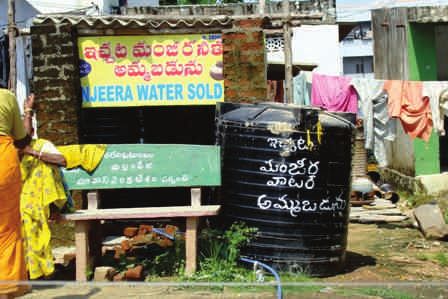
Secondly, these villages were visited initially to              2003). A study of peri urban dynamics by Narain and
understand the issues of water as they exist on the ground      Nischal (2007) has found urban entrepreneurs taking a
and analysing in-depth about the water security and             lead role as stakeholders and defining their rights over
vulnerability issues that emerged from talking to local         common properties like village ponds and lands, originally
people as well as local administration. The discussions         being managed by the villagers through collective
that were held with the community in each of these              contributions and later being sold annually by the gram
villages were based on the sub research questions.              panchyat because of poor maintenance.
(Annexure I). Primary survey was undertaken in July,
September and November, 2010. The purpose of field              Five classes of institutional arrangements have been
visits in three phases was to understand the scenarios pre      identified as arising within the complex continuum from
and post monsoon especially to understand the level of          rural to urban and falling within the range of phenomena
stress on water resources.                                      that scholars and practitioners have identified as peri-
                                                                urban and which connect to a specific peri-urban type:
Thirdly, based on these questions, analysis of concepts of        Ÿvillage PU: network-induced (sojourning, circulation,
water security, vulnerability, coping and adaptation for           migration);
peri-urban areas have been qualified further in order to          Ÿdiffuse PU: amalgamated (diffuse migration);
finalise the villages to be taken up in the final study based     Ÿchain PU: reconstituted (chain migration);
on the strength of the issues identified.                         Ÿin-place PU: traditional (in situ urbanization);
                                                                  Ÿabsorbed PU: residual (traditionalism with
Apart from primary level survey, a discussion was                  succession/displacement). Iaquinta and A.W. Drescher
undertaken with two large real estate developers, who
are operating in these specific locations as well as the        This report attempts to identify the criticalities of
Hyderabad Metropolitan Water and Sewerage Board                 increasing urbanisation on water security in peri urban
(HMWSSB) who are the sole in-charge of supplying water to       areas of Hyderabad, which has largely remained as a
the city of Hyderabad and some of its peri-urban areas. A       historical city from the 15th century till 1947 when it was
discussion was also held with a member of an activist           declared as part of Andhra Pradesh, a state within the
group in Hyderabad which operates through a network             Indian Union. In mid 1990s, when the Structural
meant for better quality of life for all citizens.              adjustment Programme was introduced by the
This study was restricted to studying areas outside the         Government of India, characterized advanced
municipal boundaries, but keeping within the Hyderabad          telecommunications and information processing and
Metropolitan Development Authority boundaries in the            technologies, Hyderabad along with many other
Rangareddy district, which is the most developed district       metropolitan cities became a node in the global web of
of Andhra Pradesh. A mandal-wise list of villages within        economic flows and linkages and inturn made Ranga Reddy
HMDA were available from HMDA as online resource, which         district, the most developed district of the state. This
was used as a base to start the process of selection of         report reveals the results of a scoping study to identify the
villages.                                                       peri-urban areas of the city based on selected criteria and
                                                                understand the dynamics of growth in these transition
Review of literature                                            zones and the impact of urbanisation on specific selected
                                                                locations and its implications for availability of and
Development activities in the fringe areas of cities results    accessibility to water resources. The issues emanating
in increasing mobility of production factors such as            from preliminary discussions with local people and other
capital, labour, technology and information to the urban        concerned agencies and contextualising the information
fringe near mega cities. This tends to make intensive           with regard to water security and vulnerability has been
demands on the environmental resources and poses                the key concerns addressed in this report.
problems by eating into valuable natural habitats like
wetlands and core forest areas, and causes loss and             The Hyderabad Urban Agglomeration (HUA) consists of the
damage to prime farmlands resulting in the increase of          Municipal Corporation of Hyderabad (MCH), 12-peripheral
impervious surface.( OECD, 1990, Hasse and Lathrop,             municipalities, Secunderabad Cantonment, Osmania

                                                                                                                        2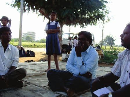
1981-1991                                   1991-2001

   MCH                                                   45.24                                            19.02

   Surrounding Municipalities                            160.53                                           71.72

   Others                                                39.13                                            25.00
Table 1Percentage Growth Rate of Population in the components within HUA
Source: Calculation from data in GHMC Hyderabad City Development Plan, undated.

University and other areas. In recent times, the 12                               The table below shows that the level of urbanisation has
surrounding municipalities have been assimilated and the                          been decreasing from 1981-1991-2001, in the municipal
Greater Hyderabad Municipal Corporation has been                                  corporation area of Hyderabad and the other areas. But,
formed. The growth rate of population in these three                              the surrounding municipalities show increasing levels of
components within the Hyderabad Urban Agglomeration is                            urbanisation during the same period.Another figure points
shown in the table below:                                                         to the density of population in theHUA along with
                                                                                  surrounding districts, with Rangereddy (1 as marked in the
A future projection of population for the HUA is shown in                         figure 1) registering maximum density of population
the following graph. This graph reveals an interesting                            followed by other districts of Nalgonda (3 as marked in the
trend, whereby the population of the surrounding                                  figure 1), Medak (4) and Mehbubnagar(5). The darkest
municipalities will grow very rapidly and is expected to                          section indicates highest density shown in the centre of
touch the population of the main corporation, which                               the figure as HUA.
indicated that growth and development has been
happening and will continue to happen in the surrounding
areas of the main city. These areas have become nodes of
development in recent years and real estate sector has
been boomed largely in these areas. If the level of
urbanisation between these three components of the
agglomeration is compared, the graph below would reveal
some interesting figures.

                                                                                  Figure 1. Source: Sreenivas and Grace, undated.

     Graph 1. Projected Population figures (in lakhs) for components of
     Hyderabad Urban Agglomeration (2001-2021)
     Source: Calculation from data in GHMC Hyderabad City Development
     Plan, undated

                                                                     1981                      1991                                 2001

   MCH                                                 77.49                          69.95                            63.35

   Surrounding Municipalities                          14.02                          22.71                            29.67

   Others                                              8.49                           7.34                             6.98

Table 1Percentage Growth Rate of Population in the components within HUA
Source: Calculation from data in GHMC Hyderabad City Development Plan, undated.
                                                                                                                                           3
Hyderabad is a city where globalization has penetrated                           the Draft Master Plan for the HADA, 2003) largely engaged
into the urban system, with the new IT hubs located in the                       in agriculture and agro-based industries and other non-
periphery of the city. Over and above, the city has                              farm activities.The development of business/technology
experienced capital growth in high-technology                                    parks, special economic zones, planned residential
manufacturing; financial and business related activities,                        colonies in this zone provides a different example of
etc. In 1996, the HITEC City project was inaugurated by                          private–public partnerships, seeking to attract foreign
the Government and towards the end of 1998, with 64                              investors into Hyderabad.
hectares of land (by the AP Government), 90% of the
capital (Larsen & Toubro limited) and a joint venture with                       The Hyderabad Metropolitan Development Authority
AP Industrial Infrastructure Corporation, the HITEC City                         (HMDA) was formed in the year 2008, with an area of 7,100
was set up in the peri urban zone. Since then the                                sq km under its purview by the merging of the following
landscape of Hyderabad has changed drastically. Urban                            erstwhile entities: Hyderabad Urban Development
analysts of 'information technology' from a variety of                           Authority (HUDA), Hyderabad Airport Development
theoretical perspectives in a collection of articles                             Authority (HADA), Cyberabad Development Authority
(Brotchie et.al. 1987) have repeatedly talked about a shift                      (CDA) and Buddha Poornima Project Authority (BPPA).
to a new type of knowledge economy, in which intellectual
capital is rapidly replaced by other forms of capital in the
                                                                                 Source of Water Supply for Hyderabad and its
generation of wealth and that metropolitan regions are
                                                                                 surrounding areas
the new seats of knowledge where high-tech workers want
to live and is fundamental to the geography of the 'New
                                                                                 From 1995 the Hyderabad Metropolitan Water Supply
Economy'.
                                                                                 Sewerage Board (HMWSSB) resolved to take over the
                                                                                 maintenance of water supply system of 9 municipalities
Within a decade after the first stone was laid, Madhapur
                                                                                 adjoining Hyderabad. Accordingly, the Government of
village where HITEC City is now located, was in spatial
                                                                                 Andhra Pradesh directed the municipalities in March 1996
continuity with Jubilee Hills, a posh suburb of Hyderabad
                                                                                 to hand over the water supply and sewerage operations to
with 17 villages and 51.70 sq km of area.(The Hindu
                                                                                 HMWSSB. The HMWSSB's activity in maintenance of water
Wednesday, October 10, 2001, Madhapur as part of the
                                                                                 supply and sewerage system since its constitution in 1989
CDA has been a target for capital intensive, large-scale
                                                                                 was confined to the Municipal Corporation of Hyderabad
real estate projects undertaken within the Cyberabad
                                                                                 (MCH) covering an area of 172.6 sq. km.
Development Authority. Provisions have been made for
encouraging Group Development, Gated Development
                                                                                 So far water supply of only 3 municipalities – L.B.Nagar,
and housing development like Row type, Enclaves, Group
                                                                                 Kukatpally and Qutbullapur have been taken over by the
Housing/Group visa-versa traditional plotted
                                                                                 board. At present, water is being supplied to Hyderabad
development (Hyderabad Urban Development Authority).
                                                                                 city from four sources:
Another development corridor is the Hyderabad Airport
                                                                                 1.       Osman Sagar on Musi river
Development Authority (HADA), which emerged with a
                                                                                 2.       Himayat Sagar on Esi river
view to promoting and securing planned development of
                                                                                 3.       Manjira Barrage on Manjira1 river
the areas in and around the new International Airport at
                                                                                 4.       Singur Dam on Manjira river
Shamshabad, the State government declared the area as a
special development area under the aegis of the Andhra
                                                                                 To cope with the increasing demand, the Government has
Pradesh Urban Areas (Development) Act, 1975.The
                                                                                 undertaken a project worth Rs 809.62 crore with Maytas,
jurisdiction of HADA covers 70 revenue villages and 19
                                                                                 Larsen and Toubro and Kirloskar Brothers for drawing
hamlets all falling in Ranga Reddy district, with a total
                                                                                 water from the Godavari in Kondapak and Ghanpur along
population of 1,54,646 (Census, 2001 cited in Report on

                                                                                                                                                     4
1
 Manjira is a tributary of the Godavari river and flows through the states of Maharashtra, Karnataka and Andhra Pradesh. Nizam Sagar was constructed
across the Manjira River between Achampeta and Banjapalle villages of the Nizamabad district in Andhra Pradesh, India. Singur Reservoir on Manjira River
in Medak District is a sustained drinking water source for Medak and Nizamabad districts of Hyderabad as well as the adjoining twin cities of Hyderabad and
Secunderabad.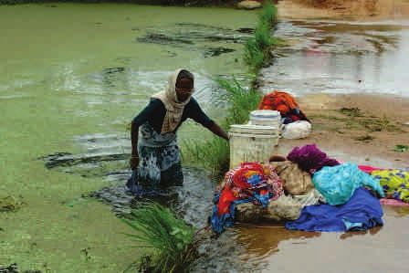
Karimnagar road near Hyderabad. The work entails                   The area around the Rajiv Gandhi International Airport is a
transmission of 735 million litres per day of treated              semi-arid zone, dotted with numerous lakes and kuntas.2
Godavari water from the reservoir. (DNA, 2008). For this           There are 140 lakes and kuntas in this area, one of the
purpose 140 acres of forest land from Rangareddy district          largest being Himayatsagar on the northwest. One of the
is required for the proposed project. So far, there is no          largest manmade is the Himayatsagar in the northwest,
clearance from the forest department. Apart from forest            whose catchment lies in an area, where recent
areas, land acquisition in Karimnagar, Medak and                   developments have started in full swing (Report on the
Rangareddy is in progress, as reported by HMWS&SB                  Draft Master Plan for the erstwhile HADA, 2003). 70 per
director (projects) M Satyanarayana. He stated “If all goes        cent of this lake has already shrunk due to drying up of the
well, residents of six surrounding municipal circles and           smaller lakes in the surrounding areas accentuated by low
two posh areas in the GHMC core area would get drinking            rainfall and low groundwater recharge along with
water” (The Times of India, Oct 21, 2010) .                        construction of the International Airport
                                                                   (Ramachandraiah and Prasad, 2004). The area also has
Water security for peri-urban areas in                             good fertile agricultural lands, especially at Ravirala,
                                                                   Kongara, Chowdarypalli, Narkhoda, Adibhatla, Dosawada
Hyderabad: Impact of urbanisation and
                                                                   etc. (Report on the Draft Master Plan for the erstwhile
Climate change                                                     HADA, 2003).

The development process in Hyderabad however has                   A survey done in Hyderabad in 2003, revealed the plight of
proved to be quite unsustainable and has turned out to be          low income households in accessing water supplied either
a serious threat to the city and its environs. The                 once in alternate days for a few hours or once in three or
development has specially affected basic amenities                 four days (Kennedy and Ramachandraiah, 2006 cited in
especially water supply for the increasing population in           Ramachandraiah and Prasad, 2008). This is in sharp
the newly developing areas. Hyderabad being located in             contrast to the large quantity of water supplied to the IT
an area with hard-rock aquifer has very limited                    companies and other institutions like the Indian School of
percolation while water drawn from the aquifer far                 Business (ISB) and the National Academy of Construction
exceeds the amount that is actually recharged. The                 (NAC). The drinking water is supplied by tankers (which
groundwater depth during the dry season and during the             make about 5 trips a day) by the local municipality. The
monsoons when correlated to rainfall over the last 10              plan to lay pipelines so that domestic connections can be
years can reveal the gravity of the problem (Massuel,              given to those who have the ability to pay clearly points to
et.al. undated). There has been progressive decline in the         the concept of 'users pay', which brings in the inequality
per cent of rainfall converted into inflows due to                 and water equity issues.
increased usage of surface and groundwater in the
catchment areas surrounding Hyderabad. Historical data
shows that there were 932 tanks in 1973 in and around              A report by the Groundwater Board shows that in the
Hyderabad which came down to 834 in 1996. Consequently             Ranga Reddy district, “22 mandals out of 37, utilize more
the area under water bodies got reduced from 118 to 110            than 70% of the available ground water resource. Based on
sq.km. About 18 water bodies of over 10 hectare size and           the stage of ground water development 15 mandals are
80 tanks of below 10-hectare size were lost during that            categorized as safe (less 70% of available resource), 8 semi
period in the HUDA area. Besides the large water bodies,           critical (70-90%) to critical (90-100%) and 12 over
numerous small water bodies in the peri urban zones also           exploited (more than 100%). The maximum stage
shrunk, when the city underwent a wave of real estate              development of groundwater is 187% is in Shamirpet
growth (Ramachandraiah and Prasad 2008).                           mandal, which falls within the peri urban areas of
                                                                   Hyderabad. Shamshabad and Maheswaram mandals, also

                                                                                                                          5
2
    Kunta is local term in telugu when referred to a small lake.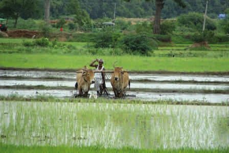
falling within the peri-urban area have been categorised          differently according to the scale of use. (Water Moves,
as 'over exploited' (CGWB, Government of India, Southern         2008)
Region, 2007: 22,23).
                                                                 Despite some arguments about the need for 24x7 water
An Indo-German Project has associated itself with the city       supply, it has been countered by arguments, which call for
of Hyderabad with respect to issues of Climate change,           4 hours of daily uninterrupted supply, which is considered
water and transport. In their preliminary investigation,         sufficient for any household. Moreover, this also leads to
they observed that with Hyderabad's population expected          wastage of 20% of the water. If 24x7 supply actually takes
to grow to 10.5 million inhabitants by 2015 and driven by        place, further wastage is expected. What is needed is
consumption and lifestyle changes, per capita greenhouse         equitable distribution of water to all areas and sectors
gas emissions are constantly increasing. The use of              (ibid) must be one of the priorities in the policy
traditional biomass for fuel (e.g., firewood) is high in peri-   documents.
urban areas; at the same time, modernisation and
urbanisation processes have led to a growth of commercial        Also agricultural practices in most peri urban villages are
energy and indirect energy uses. The city has seen severe        completely dependent on groundwater and as per current
floods in 2002, strong heat waves in 2003 and three              regulation like the Andhra Pradesh Land Water and Trees
drought years between 2000 and 2007 in the city cores. Its       Act coupled with free electricity policy of the
surrounding regions have undergone serious damage                government, there is accelerated privatization of
especially to human life, property and economic                  groundwater in the state as a whole (Ramachandrula,
advancement. (German Information Centre, 2009). The              undated). Therefore policy intervention for equity and
year 2010 has also seen too much and untimely rain even in       well as groundwater regulation especially for peri-urban
winters, which was earlier not experienced in Hyderabad.         zones must be taken up as priority.
The winter rains would take place for 10-15 days across          In recent times there has been much hue and cry about the
the months of November and December in 2010, there has           city of Hyderabad losing its water bodies either due to
been 10 days of rains in November itself and it has been         pollution or encroachment. Activists groups have
unusually humid (TOI, November 19, 2010).                        developed a network involving experts from the sector
The Andhra Pradesh State Water policy which came into            called Save our Urban Lakes (SOUL). An informal
existence in 2008 has several objectives in mind.                discussion with one of the founding members, Dr. Jasveen
ŸImproving the productivity of the State's water resources       Jairath revealed the grave situation that Hyderabad is in
to achieve economic, social, and environmental                   and why the government is not showing any kind of
objectives through an outcome orientated approach for            proactiveness with regard to the situation. She clearly
institutional and investment activities.                         highlighted the level of corruption which gives a
ŸEnsuring water security to the State's population to            stronghold to land developers to flout all building
maximize the benefits to various users of water while            regulations. Also in Hyderabad, there is no planning done
minimizing vulnerability to droughts, floods, and                before a project starts, it begins later, which not only
pollution.                                                       disrupts all the basic amenities but has detrimental
ŸPromoting sustainable use of groundwater.                       impact on local communities. She strongly spoke in favour
ŸConserving and protecting water bodies and wetlands,
                                                                 of the need to question the government policies regarding
through regulation and enforcement of standards for              urban development policies and challenge them and that
water infrastructure, usage and waste disposal.                  can only be done by further understanding and research
ŸRegulating the use of the land around water bodies.
ŸEnforcing the recycling of industrial effluents and
                                                                 coupled with pro active involvement of activist groups and
wastewater for secondary uses (Andhra Pradesh State              networks. Her network has already communicated with
Water Policy, 2008)                                              local people around some of the lakes within the city that
ŸRegarding pricing of water, HMWSSB would try to bring           are under severe threat and have identified issues which
about a tariff system where users would be charged               need immediate attention of the policy makers.
                                                                 Box 1. Activist viewpoint on the issue
                                                                 Source: Personal interview with Dr. Jasveen Jairath on 26.11.2010

                                                                                                                                 6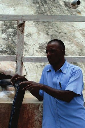
Analysis                                                              These mandals are shown in the map below.
                                                                      Qutubullahpur and Rajendranagar mandals as per the
The scoping study survey as mentioned earlier was                     report by the CBGA, 2007 have been marked as safe zones.
undertaken beyond the Greater Hyderabad Municipal                     However, these mandals were selected because they had
Corporation (GHMC) borders, but was restricted to                     undergone maximum urban growth between 1991 and
revenue villages within the Hyderabad Metropolitan                    2001 and assumed to have grown even more over the last
Development Authority (HMDA). At the initial stages in                10 years following the economic boom. With this situation
order to select the specific mandals for the study,                   at hand, it was important to find out whether these two
secondary data from census was collected and analysed to              mandals could actually be categorised as safe, which
understand the level of urbanisation and growth of urban              would only be revealed after visiting the sites, where
population in the Hyderabad Urban Agglomeration (HUA)                 residential, commercial and industrial growth is
along with the surrounding mandals of the Rangareddy                  maximum.
district.
                                                                      Villages within these mandals were selected based on
ŸBased on the analysis, four mandals were selected.                   their locations around residential and commercial
Another basis for selection was groundwater status and                complexes by referring to online information about
real estate growth that had taken place in specific                   location of large residential and commercial complexes in
mandals. The Mandals selected were adjacent to                        these specific mandals along with location of SEZs. These
Hyderabad and are listed below :                                      villages were then identified and located on wikimapia in
                                                                      order to understand the terrain from a bird's eye view.
 ŸShamirpet located towards the north-east (over-
                                                                      Some of these villages are so small that they could not be
 exploited groundwater category)
 ŸQutubullahpur towards north-west, (safe groundwater
                                                                      found on the map, so in such cases only larger villages
 category)                                                            were selected around a particular development enclave.
 ŸRajendranagar towards south east and south (safe
                                                                      A total of 16 villages were initially selected and surveyed
 groundwater category)
 ŸMaheswaram towards the south-east (over-exploited
                                                                      based on the sub research questions. A table representing
 groundwater category)                                                the basic information of each of these villages is
                                                                      providedbelow:

               Source: CGWB, Government of India, Southern Region, 2007
                                                                                                                            7
Names of
 villages visited          Name of the          Distance from               Socio-economic
 and distance                                   the city centre                                                        Issues/Concerns
                           Mandal                                           characteristics
 from Hyderabad

 Aliabad                 Shamirpet              25- 30 kms              Largely an agricultural                 Water for irrigation, drinking and
                                                (approx)                village with some                       other purposes is available
                                                                        households engaged in the               through        borewells. The
                                                                        manufacturing and service               Shamirpet lake is never full
                                                                        sector in Hyderabad                     enough to be utilised for
                                                                                                                irrigation. Crops are largely water
                                                                                                                consuming like paddy. The channel
                                                                                                                constructed to bring water from
                                                                                                                Shamirpet now runs almost dry.
                                                                                                                Village population for drinking,
                                                                                                                cleaning and agriculture, SEZs,
                                                                                                                Commercial and residential
                                                                                                                complexes and government
                                                                                                                establishments like Airforce base.

 Turkapally              Shamirpet              30 kms (approx) Village farthest from the                       Special Economic Zone (SEZ)3 gets
                                                                city, but well developed.                       24x7 water while no manjira
                                                                Some agricultural land is                       connection in the village, which
                                                                left, but most people have                      depends on groundwater for
                                                                started working in the city or                  drinking which has high fluoride
                                                                are engaged in menial jobs                      content.
                                                                in the SEZ located nearby.

 Thumkunta               Shamirpet              15 kms (approx) Relatively a very developed Receives manjira water for
                                                                village located adjacent to drinking and no further strong
                                                                the main road. Agriculture water related issues
                                                                has almost ceased to exist
                                                                and real estate development
                                                                is visible with small
                                                                apartment and individual
                                                                houses spread around various
                                                                parts of the village. Everyone
                                                                is engaged in local business
                                                                or are working in factories
                                                                nearby or commuting to the
                                                                city.

 Devara Yamjal           Shamirpet              20 kms (approx) Tucked inside from the main                     Dependent on water released
                                                                road where most of the                          from Hakimpet, which has an
                                                                inhabitants are not                             airfoce station and huge
                                                                practising agriculture due to                   quantities of government lands.
                                                                low water table. Are engaged                    Flouride pollution has destroyed
                                                                in small businesses in the                      the network of pipes in certain
                                                                village or are working in the                   areas reducing the flow of water
                                                                other villages nearby.                          tremendously.

                                                                                                                                                        8
3
  A geographical region that has economic and other laws that is more free-market-oriented than a country's typical or national laws. "Nationwide" laws may
be suspended inside a special economic zone. The category 'SEZ' covers a broad range of more specific zone types, including Free Trade Zones (FTZ), Export
Processing Zones (EPZ), Free Zones (FZ), Industrial Estates (IE), Free Ports, Urban Enterprise Zones and others. Usually the goal of a structure is to increase
foreign direct investment by foreign investors, typically an international business or a multinational corporation (MNC).
Kompally Qutubullahpur 10-15 kms Very large urban village Domestic high end users but no
(approx) adjacent to the main road. manjira water. Water for all
An insignificant number of purposes is available through
villagers have agricultural borewells.
lands left, but mostly not
cultivated. Some factories
and the service sector in the
city are the main employers
for the villagers. Largely
occupied by migrants.
Doolapally Qutubullahpur Very limited agriculture Problems in access to labour and
being pursued. fertilizer. Cost of crop production
is very high due to high rates for
diesel.
Mallampet Qutubullahpur 30 kms (approx) Relatively small village with Much of the agricultural lands has
a good proportion of been acquired for the outer ring
migrants from other districts road. Illegal water extraction by
of Andhra Pradesh. Some tankers, only one lake in the
households have held onto vicinity which is a source of water
their agricultural lands but for the entire village, subject to
are not cultivating. pollution during the monsoons.
Manjeera water is brought in tanks
from other places and sold in the
village.
Bachupally Qutubullahpur 25 kms No agriculture. All lands give Dependent solely on bottled water
away for realestate growth. for drinking because groundwater
Large number of migrants. is polluted by the nearby
factories. No majira connection
despite repeated requests.
Manikonda Jagir Rajendranagar 25-30 kms Large village with huge Very high end domestic users
(approx) population occupying 22 owing to largescale real estate
colonies, large proportion of growth, polluted groundwater for
migrants from other states drinking, no manjira connection
of India and other districts of for villagers while manjira
AP. All working in the connection for the large
manufacturing and serice residential complexes
sector. No agriculture is
being pursued.
Manikonda Jagir Rajendranagar 25-30 kms Very small village with a Does not receive manjira water,
(approx) populationthat no longer but has a connection with the
depends on agriculture, pipeline brining water from the
because of less water in the Gandipet lake to the city of
Gandipet lake Hyderabad. No conflicting issues.
9Gandipet Rajendranagar 30 kms Very small village with a Does not receive manjira water,
populationthat no longer but has a connection with the
depends on agriculture, pipeline brining water from the
because of less water in the Gandipet lake to the city of
Gandipet lake Hyderabad. No conflicting issues.
Peerancheru Rajendranagar 30 kms No agriculturalists. People All lands have been plotted for
depend on work in the real estate. Large residential
village/in Hyderabad city complexes are coming up in the
village. No regular manjira water
supply. Dependent on bottled
water. Groundwater polluted
severely by a hospital in the
vicinity.
Gandhamguda Rajendranagar 30 kms Very little agricultural land Groundwater dependent. Some
which is cultivated by few, real estate development. No
rest are engaged in strong water issues.
manufacturing and service
sector in the city.
Neknampur Rajendranagar 30 kms Very small village with no No conflicting water issues,
agriculture. depends on Manikonda for supply.
Lake adjacent to the village is
completely polluted.
Sardarnagar Maheshwararm 35-40 kms No agriculture being Groundwater dependent. No
(approx) pursued. Most people work conflicting issues of water
in the cities and very few in
the Hardware Park
Ravirala and Latter is a hamlet, which is Polluted groundwater, forced
Janaiguda part of the Ravirala acquisition of land with no
Panchayat. Some families compensation, loss of livelihood,
still pursue agriculture water stress in the future due to
though most of the the coming up of the Hardware
agricultural lands in the Park and the Fab city. No manjira
village have been acquired connection for drinking in the
for the Hardware Park and village while pipeline connected
the Fab City to Hardware Park and Fab City for
24x7 water supply from
Nagarjunasagar.
10
4
To match the hardware needs of the IT Companies in Hyderabad, APIIC has developed Hardware Park in an area of 1200 Acres of land, located at a distance
of 14 KM from Hyderabad and adjacent to the International Air port. The Park is adjacent to Hyderabad -Srisailam Highway near Raviryal village.
5
India is making Hyderabad, in the state of Andhra Pradesh, a world-class hub for advanced semiconductor and electronics manufacturing stretched over
an area of 1050 acres. This dedicated area has become known as Fab City. The development of Fab City is being promoted by the government of Andhra
Pradesh (GoAP) which has tasked the Andhra Pradesh Industrial Infrastructure Corporation (APIIC) to oversee progress and establish public-private
partnerships with developers. Government of Andhra Pradesh (GoAP) has committed to installing a pipeline, capable of carrying of 75708236 litres of
water/day at concessional rates for multiple fabs and other manufacturing in Fab City.While selecting the villages, some major considerations peri-urban category. However, Manikonda Jagir to a large
were identified and have been analysed in this report. extent has already started showing some features of
They are: 'absorbed peri-urban'. Most of these areas have undergone
natural increase in population because of the
ŸCategory of PU as per literature within which the villages
development enclaves which have come up over the last
can be classified 10-15 years like IT parks, financial hubs etc.
ŸLocation within a development zone: Implications for
water availability Location: Implications for water availability
ŸWater uses and users and issues emerging therein
accounting for water security The peri-urban areas of Hyderabad, no matter which
categories they belong to as per the descriptions stated
Contextualising the Peri-urban categories above, are part of the Hyderabad Metropolitan
If the peri-urban categories have to be contextualised for Development Authority. The purpose of selecting villages
the 16 villages visited during the scoping study, it is seen within this development zone was firstly to identify the
that they can be placed within most of the categories role of HMDA for development of basic infrastructure in
stated in literature except chain peri-urban, the the villages located within its jurisdiction. Another reason
characteristics of which cannot be identified among the for selecting villages in this zone was because of their
sites visited. location outside the purview of the Municipal Corporation
and therefore do not receive water supply from the Water
One village in Maheshwaram mandal (Sardarnagar) can be Board and this has specific implication with regard to the
categorised within village peri-urban because primary research questions highlighted earlier. Most of
geographically, the location of this village is a little away these villages visited during the scoping study are
from the city but socio-psychologically it has been largely undergoing mammoth changes in land use owing to
influenced by the urbanisation process and agriculture has developmental activities undertaken by the HMDA, APIIC
almost ceased to exist. This village is characterised by and other related government departments who are in
out-migration to the city for work. fact developing areas for attracting foreign investment
into the city, but are not engaged in micro-level
Three villages in the Shamirpet mandal (Turkapally, development of the villages. Most of the villages are not
Aliabad and Devara Yamjal) one in Qutubullahpur mandal even aware that they are part of HMDA. The development
(Mallampet), two in Rajendranagar mandal (Gandipet and projects around many of the villages visited have had
Neknampur), two in Maheshwaram (Ravirala and detrimental impact on quality and quantity of water.
Janaiguda) and two in Shamshabad mandal (Peddashahpur
and Pedda Golkonda) can be categorised under 'in-place Water Security
peri-urban' because geographically they are at the fringe
of the city, between 35-40 kms kms from the core areas of In the context of the above discussions on the impact of
the twin cities of Hyderabad and Secunderabad, which has the development enclaves for water availability in the
started transforming itself, characterised by 'multiple- peri-urban areas, the water security issue in these peri-
source point in-migration', but holds onto its traditional urban areas may be analysed deeper. While analysing the
institutions to an extent and where there is an interface issue of water security in peri-urban areas, the most
with urban formal structures like SEZs, Genome Park, ICICI important section that one needs to concentrate is on the
Knowledge Park, large residential enclaves. The users of water and uses to which water is put in the peri-
development process has lead to growth of residential urban zones, which solely determines the security
hubs attracting the population from the city to live here perspective. In the villages of the four mandals where
and in turn calls for possible oldtimer-newcomer conflict. field visits were undertaken, the rationale behind the
selection of villages was the variety of water users who
The remaining villages within Qutubullahpur mandal exist there.
(Kompally, Doolapally and Bachupally), Rajendranagar
m a n d a l ( M a n i k o n d a J a g i r, Pe e r a n c h e r u a n d
Gandhamguda) can be largely included within the diffuse
11Shamirpet Mandal through bores upto 400 ft deep. Water for drinking is also
available through bores installed by the panchayat and is
In Shamirpet mandal, the largest users of water were the stored in tanks which supply water for 6-7 hours daily
households for drinking and cleaning purposes, through pump. The waterman plays a pivotal role in
agriculture and newly developing residential and facilitating the process of water supply to all households
commercial enclaves like Special Economic Zones (SEZs), in the village. To support their daily expenses, many
Genome Park6, ICICI Knowledge Park7. In Aliabad, farmers villagers in Aliabad have shifted to working in the nearby
reported that they depended on the Shamirpet Lake for factories or the city which is well connected by bus. Water
irrigation, from where a channel brought water to the of the lake is a lifeline for the people of this village and the
village, but owing to insufficient rainfall in the last several lake is slowly being encroached by developmental
years, the lake was never filled enough to support activities. The channel string rain water has become
agriculture, resulting in shorter periods of cultivation and defunct and only has a thin film of water sufficient enough
mostly for self consumption. Although most of the for villagers to wash their clothes as seen in the collage of
villagers here still practise agriculture, the water for photos below.
irrigation is available from groundwater that is drawn
The water man plays a vital role in
Aliabad, Shamirpet near
Hyderabad in facilitating the
supply of water from the tank
behind him to all households in
the village
Engaging with local communities to understand issues of water in Aliabad
A woman washing clothes in the waters of a channel in Aliabad village,
Agricultural practises in Aliabad are dependent on borewater and only in constructed to hold rainwater and drain excess water into another
some cases water from the Shamirpet lake is available for irrigation, channel bringing water from the nearby surface storage to the
when the lake is full agricultural fields which remains dry during most part of the year
12
6
Genome Valley is the first state-of-the-art biotech cluster in India for life science research, training and manufacturing activities. Advantages in Bio-
pharma sector in Andhra Pradesh, enable more than hundred biotech companies to flourish in this sector. Spread over 600 sq. kms. around the IKP
Knowledge Park, the SP Biotech Park and the ICRISAT Agri-business Incubator, the Genome Valley provides world-class infrastructure facilities to over 100
biotech companies.
7
Launched by ICICI Bank Ltd. in partnership with the Government of Andhra Pradesh, the Park is committed to facilitating business-driven Research &
Development.In Devara Yamjal, agriculture has ceased to exist and the scenarios, though both have experienced the impact of
villagers are largely engaged in the manufacturing and urbanisation. Thumkunta (amongst those surveyed) is the
tertiary sectors, and being located away from the main only village within the HMDA, which receives Manjira
road, there has not been much impact of urbanisation water for drinking. Separate bores have been installed by
although lands have been sold off for development the panchayat for other purposes. This village is in an
purposes, largely residential. The problem in this village is advantageous position because it is nearer to the city and
however very unique and has implications as far as water therefore receives Manjira supply. The panchayat member
security is concerned. The groundwater level in this spoken to reported that the primary reason for villagers
village is extremely low and limited sources that are discontinuing agriculture was the depleting groundwater
available are not sufficient for drinking and other levels. Severe fluctuation in groundwater level has been
domestic chores. Hence, the village receives water noticed by the villagers. In summers, the private water
through a pipeline from a neighbouring village called tankers) bring water from surrounding villages. Some
Hakimpet, where the water table is higher and some villagers also sell water from their lands, where the water
villagers are engaged in agriculture. However, Hakimpet's level is high. Being located on the main road, it
land is largely occupied by an airforce base and other experienced rapid growth through real estate
newly developing government colonies. Although development and villagers found it more lucrative to sell
Hakimpet village is part of Devara Yamjal panchayat, its their lands and invest the money for small business in the
location is in proximity to Secunderabad and adjacent to city. This village would never be able to access water from
the main road. This village is likely to be urbanised further the Shamirpet Lake because of the higher terrain on which
in the years to come, resulting in increased demand for it is located, which was another serious cause of lack of
water and with erratic monsoons and lack of management water. Turkapally on the other hand has no access to
practises in place, the available groundwater in Hakimpet manjira water supply, although the adjacent SEZ, ICICI
will also be under severe stress. In such situations, Devara Knowledge Park and the Genome and Biotechnology Park
yamjal's access to water may also be restricted. Moreover, receive 24x7 manjira supply from the water board. Many
the pipeline brining water to Devara yamjal and those villagers work in the SEZ and that is their source of
distributing water to different parts of the village has also livelihood, since agriculture is on the decline. During
been clogged by salt and fluoride deposits which restrict summer months, there is a scarcity of drinking water
the smooth flow of water. This water is however filtered which is then accessed through tankers that bring water
through a treatment plant which was set up by the Byrraju from specific locations in the village, where the water
Foundation initially, and is now being managed by the table is high. The landowner charges for the water drawn
panchayat on a meagre payment from the villagers (Rs 1.5 from his bore and the villagers pay for it, though the
for 12 litres can of water), but this amount is not sufficient fluoride levels are quite high and results in health
and the panchayat has to use its own funds to maintain the problems for many who cannot afford bottled water.
structure. The pipeline if replaced will require funds upto Repeated requests for a manjira connection has been
1 crore, which is an impossible amount of money for the turned down by the government officials who ask the
panchayat to raise. Even to repair the most troublesome panchayat to pay a high amount of money to get a
sections, the cost involved would be 15-20 lakhs, which connection. In case of Turkapally, there is a severe water
the panchayat cannot afford at the moment. With limited equity issue, which emerged during the field visit and the
finds and dependency on neighbouring village for its economically and socially powerless villagers' lives are at
water, Devara yamjal is at threat as far as water security is stake.
concerned.
Turkapally and Thumkunta (former farthest from the city
and the latter nearest to the city) have very different
13Research team in communication with villagers in Turkapally, the site for Lake in the vicinity of Turkapally. Some fishing is also done in this lake.
SEZ, Genome Park, Biotechnology Park and ICICI Knowledge Park
Prajay Water Front, a large residential complex in Turkapally along the Genome Park coming up in Turkapally
side of the lake
Qutubullahpur Mandal “Local markets sell products at lower prices. Why should a
farmer engage in agriculture? Most of them are now
In this mandal, four villages were visited during the moving into non-agricultural sector and working in
scoping study. The person who spoke to the Hyderabad Secunderabad, which pays them well enough for their
research team was Mr. B. Satyanarayana, who is the single personal luxuries”, said the single window Chairman.
window Chairman for Kompally, Bahadurpally and Secunderabad can be reached within 30 minutes by the
Doolapally. Talking about the changing practises of State Transport buses.
livelihood in these three villages, he mentioned that these
three villages are facing severe crisis of fertilizer. The cost Another reason for people to sell their lands for real estate
of bringing fertilizer from faraway places tends to development as reported by the Chairman is the problem
increase the cost of production whereby output is costlier. of labour.
14With the NREGA coming into place, labourers are few and The gram panchayat, sarpanch, an old woman named
those who are willing to work ask for very high rates upto Kamsaiyah, seemed completely frustrated with her
Rs 250/- per day for work from 10 in the morning to 5 in the attempts to bring manjira water to the village. The
evening along with food. This becomes very expensive for agitated Kamsaiya said, “get me manjira water and then
a landowner wanting to continue with agriculture as come and talk to me”. She however, mentioned how lands
means of livelihood. Moreover, labourers are not willing to have gone over time and villagers have shifted from
relocate either. The cost of diesel has been rising making it agriculture and moved to the tertiary sector. There are
difficult to irrigate the land. A few landowners who still about 8 lakes in the vicinity but all of them are polluted.
wish to continue agriculture have sold their lands and Many villagers who quit agriculture are either working in
bought new lands near Dindigul and are cultivating there. the chemical factories, or elsewhere in the city. Some of
Water per se is not a crisis in these villages and right now them have bought lands in Sangareddy and are cultivating
despite real estate development in the vicinity; the there. No new factories have come up but the existing
villagers are not threatened because most of them are not ones continue to pollute in a big way. The users of water in
occupied. The reason is said to be inertia and scepticism this village are factories and households (lower income
within the people to invest in property in Hyderabad and higher income groups). Another problem faced by the
owing to the recent demand for a separate Telengana village is severe water logging problems. Being on a lower
state, which has led to reduced land prices. Most of the ground, it is badly affected after rains, when water tends
bores used for agriculture are upto 600 feet deep and to collect here causing much havoc. Meetings have been
water for drinking is available through manjira water held with officials in recent times with regard to both
supply every 2-3 days for 2 hours. Villagers store their these issues, and they have been promised manjira water,
water before the next supply. Since this village was visited but nothing has materialised till date. The demand for
during the monsoons, this village reported that 2010 has water in the domestic sector is ever increasing with new
been a year of very good rains and the surrounding lakes residential enclaves mushrooming in all directions,
have been filled upto the brim only after 12 years. somewhat abruptly. This calls for severe water stress for
the village, which comprises low income households who
Bachupally village, also part of the Qutubullahpur mandal have to survive on polluted water for their daily needs.
is located on the other side of Hyderabad in an area where
real estate growth has taken place in full swing. It is just 6 Mallampet, 7-8 kms away from Bachupally is one of the
kms from the nearest locality of Kukatpally which falls villages from where water is brought in tankers during
within the jurisdiction of the municipality. The nearest summers and is a very interesting case in point. This is one
village is Nizampet which has been influenced by of the many villages from where the tankers extract
increasing urbanisation and has completely given way to water, largely private entrepreneurs. This village was
high rise buildings and large residential complexes and selected after visiting Bachupally, where people
there is a very high demand for water, which is fulfilled mentioned that water is brought from Mallampet. The
either through the borewells or through tankers which Sarpanch, Vekatesham indicated that the village has
bring water from the surrounding villages, 5-10 kms away. about 500 households, with about 50 acres of agricultural
Despite being within the Hyderabad Metropolitan land left but only a small portion of it is actually being
Development Authority, this village does not have a source cultivated.Some villagers have sold their lands and have
of clean drinking water and is dependent on the bottled bought lands near Narsapur. The primary reason indicated
water or water delivered through tankers. Most of the by him for change in the livelihood pattern is the cost of
agricultural lands in the village have been sold, because labour in agriculture. “If industry pays Rs 150/day and
agriculture could not be pursued due to water pollution, agriculture pays only Rs 80/day, the labourer prefers to
which has proved to be dangerous for drinking as well. work in the industry”, says the sarpanch. The primary
Even today, some local people who cannot afford bottled source of water in the village comes from 15 bores that
water are forced to drink the water that is polluted by the have been dug all over the village upto 400 ft deep.
chemical factories.
15If lakes are full, the water table tends to be high and with for 20 litres. Many of the bores located near the lakes,
8 hours of electricity, water can be easily pumped and tend to get further polluted especially during the
distributed to all the households for their personal uses monsoons, when the entire drainage water from the
and there isn't much scarcity. This year the lakes are full villages flow into these lakes. The water pollution
because of good rains. The first bore was dug in 1987, problem started in 1986. When the surrounding villages
which later dried up and due to pollution of the water created a hue and cry over their sources of water
from the surrounding industries; new bores had to be dug becoming unsuitable, several complaints were filed, and
later. Five years back, some more have been dug due to the government regulations stopped any further growth of
increasing demand for water in several other parts of the industries. “Only new factories cannot be set up as per the
village along with new storage facilities and new pipe regulation, but the existing ones still operate and
connections. To maintain this as well as a treatment plant discharge their effluents into the lakes”, says the
which has been set up, Rs 2 is collected monthly from each Sarpanch. During the construction of the ring road, almost
household. The village seems to be self-sufficient, but the 78 acres of land has been acquired. The construction is
illegal extraction of water has been a source of worry for underway. However, the impact of builders and real estate
the panchayat. For agricultural purposes, there are developers have not been felt very strongly in the village
separate bores installed by villagers. But because of right itself, though lands have been sold to developers and have
to water tied to right to land, many of the villagers who been plotted for future growth. However, only till 1997,
have a bores dug in their lands for agriculture are actually agriculture was the source of income for a large part of the
selling water to private tanker companies who inturn are village. And later, since 2002, with real estate boom,
selling it to the industries nearby. Each villager makes households started selling their lands. But there are no
about 150-200 from each tanker and the tankers visit the large apartment complexes in the vicinity. The water
village almost 15 times in a day to abstract water. The security concerns also emerged very strongly during the
villagers are finding this more profitable than agriculture field visit to Mallampet, whose water resources are being
itself. Some villagers are also buying manjira water in big randomly exploited by illegal tankers, selling water to the
tanks from surrounding villages which get the supply and industries, who inturn pollute the groundwater, by
are selling it to the village community at Rs 10-15 (approx) releasing effluents. This is a vicious cycle which needs
further investigation.
Factories near Bachupally, that are responsible for polluting the Private water tankers flourish and operate in Mallampet, near Hyderabad
groundwater which is completely unsuitable for drinking and for where the surface water is still available for use and farmers too sell
agriculture and has affected all the surface sources in the nearby water from their borewells, situated near the surface water sources to
villages, except afew these entrepreneurs for reselling to the industries and other residential
areas devoid of regular drinking water supply from the Water Board,
while local people suffer
16You can also read