STRATEGIC HOUSING DEVELOPMENT, BLACKWOOD SQUARE, NORTHWOOD, SANTRY, DUBLIN 9 - Planning Report & Statement of Consistency
←
→
Page content transcription
If your browser does not render page correctly, please read the page content below
STRATEGIC HOUSING DEVELOPMENT, BLACKWOOD
SQUARE, NORTHWOOD, SANTRY, DUBLIN 9
Planning Report & Statement of Consistency

                                                            MH18062
                                                   Strategic Housing
                                             Development Blackwood
                                                              Square
                                                                F001
                                                  2nd December 2019

                                                   rpsgroup.com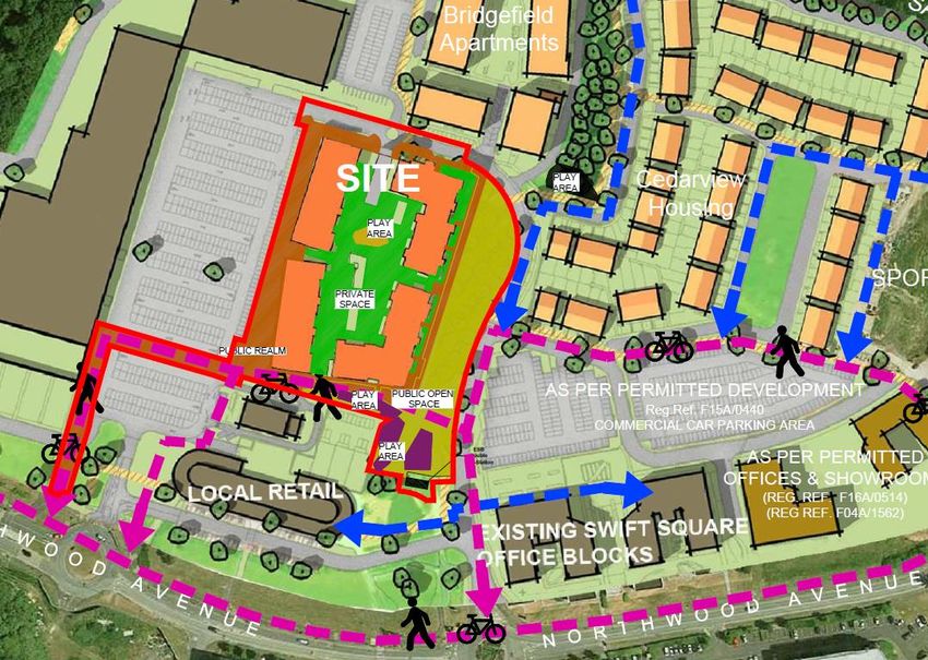
STATEMENT OF CONSISTENCY

Document status

Version      Purpose of document                  Authored by            Reviewed by     Approved by       Review date

F01          Final                                Mike Higgins           Carl Mogensen   Helena Gavin      01/12/2019

Approval for issue

Helena Gavin                                                                             2 December 2019

© Copyright RPS Group Limited. All rights reserved.
The report has been prepared for the exclusive use of our client and unless otherwise agreed in writing by
RPS Group Limited no other party may use, make use of or rely on the contents of this report.
The report has been compiled using the resources agreed with the client and in accordance with the scope
of work agreed with the client. No liability is accepted by RPS Group Limited for any use of this report, other
than the purpose for which it was prepared.
RPS Group Limited accepts no responsibility for any documents or information supplied to RPS Group
Limited by others and no legal liability arising from the use by others of opinions or data contained in this
report. It is expressly stated that no independent verification of any documents or information supplied by
others has been made.
RPS Group Limited has used reasonable skill, care and diligence in compiling this report and no warranty is
provided as to the report’s accuracy.
No part of this report may be copied or reproduced, by any means, without the written permission of RPS
Group Limited.

 Prepared by:                                                       Prepared for:

 RPS                                                                Cosgrave Developments

 Michael Higgins
 Project Planner

 West Pier Business Campus
 Dun Laoghaire, Co. Dublin A96 N6T7

 T     +353 1 488 2900
 E     michael.higgins@rpsgroup.com

MH18062 | Strategic Housing Development Blackwood Square | F001 | 2nd December 2019
rpsgroup.com                                                                                                     Page ii
STATEMENT OF CONSISTENCY

Contents
1      INTRODUCTION ................................................................................................................................ 1
       1.1 Proposed Development ............................................................................................................ 1
       1.2 Statement of Consistency ........................................................................................................ 1
       1.3 Format of Report ...................................................................................................................... 1
2      SITE LOCATION AND URBAN CONTEXT ...................................................................................... 2
3      PLANNING HISTORY ........................................................................................................................ 4
       3.1 SUBJECT LANDS .................................................................................................................... 4
       3.2 ADJACENT LANDS ................................................................................................................. 5
4      DESCRIPTION OF PROPOSED DEVELOPMENT ........................................................................... 7
       4.1 Proposed Development............................................................................................................ 7
       4.2 Key Site Statistics .................................................................................................................... 7
       4.3 Residential................................................................................................................................ 8
       4.4 Commercial Units ..................................................................................................................... 9
       4.5 Childcare Facility .................................................................................................................... 10
       4.6 Access and Connectivity ........................................................................................................ 10
       4.7 Open Space and Landscaping ............................................................................................... 11
            Green Routes ......................................................................................................................... 11
            Public Realm .......................................................................................................................... 11
            Play     11
            Communal Courtyard ............................................................................................................. 11
       4.8 Parking ................................................................................................................................... 12
            Cycle Parking ......................................................................................................................... 12
            Car Parking ............................................................................................................................ 12
       4.9 Site Services .......................................................................................................................... 12
            Lighting 12
            Refuse Bins ............................................................................................................................ 13
            ESB Substation ...................................................................................................................... 13
            Flood Risk Assessment .......................................................................................................... 13
       4.10 Visual Impact .......................................................................................................................... 13
       4.11 Materials and Finishes ........................................................................................................... 13
       4.12 Integration with Existing Area................................................................................................. 14
5      RATIONALE ..................................................................................................................................... 14
6      ENVIRONMENTAL APPRAISALS .................................................................................................. 15
       6.1 Environmental Impact Assessment Report ............................................................................ 15
       6.2 Appropriate Assessment Screening Report ........................................................................... 15
7      PLANNING POLICY – STATEMENT OF CONSISTENCY ............................................................. 16
       7.1 Introduction............................................................................................................................. 16
       7.2 Project Ireland 2040 National Planning Framework............................................................... 17
       7.3 Rebuilding Ireland – Action Plan for Housing and Homelessness ......................................... 18
       7.4 Guidelines for Planning Authorities on Sustainable Residential Development in Urban
            Areas (2009)........................................................................................................................... 19
       7.5 Sustainable Urban Housing– Design Standards for New Apartments 2018 ......................... 21
       7.6 Design Manual for Urban Roads and Streets 2013 ............................................................... 25
       7.7 Urban Design Manual – A Best Practice Guide ..................................................................... 25
       7.8 Urban Development and Building Heights ............................................................................. 30
       7.9 Guidelines for Planning Authorities on Childcare Facilities ................................................... 32
       7.10 The Planning System and Flood Risk Management .............................................................. 33
       7.11 Regional Spatial and Economic Strategy ............................................................................... 34
       7.12 Transport Strategy for the Greater Dublin Area 2016 -2035 .................................................. 36

MH18062 | Strategic Housing Development Blackwood Square | F001 | 2nd December 2019
rpsgroup.com                                                                                                                                         Page iii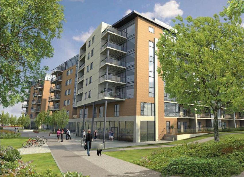
STATEMENT OF CONSISTENCY

        7.13 Fingal Development Plan 2017-2023 ..................................................................................... 37
8       COMPLIANCE WITH PART V ......................................................................................................... 44
9       CONCLUSION ................................................................................................................................. 45

Tables
Table 4-1: Development Schedule ............................................................................................................... 8
Table 7-1: NPF Consistency Appraisal ....................................................................................................... 18
Table 7-2: Rebuilding Ireland Consistency Appraisal ................................................................................. 19
Table 7-3: Sustainable Residential Development in Urban Areas Consistency ......................................... 19
Table 7-4: Design Standards for New Apartment Consistency Appraisal .................................................. 22
Table 7-5: Urban Design Manual Consistency Appraisal ........................................................................... 26
Table 7-6: Building Heights Guidelines Consistency Appraisal ................................................................. 30
Table 7-7: Childcare Guidelines Consistency Appraisal ............................................................................ 33
Table 7-8: Appraisal Planning System and Flood Risk Management Guidelines ...................................... 34
Table 7-9: RSES Consistency Appraisal .................................................................................................... 35
Table 7-10: Transport Strategy Consistency Appraisal .............................................................................. 37
Table 7-11: Development Plan Consistency Appraisal .............................................................................. 40

Figures
Figure 2-1: Site Location (indicative subject lands outlined in red) .............................................................. 2
Figure 2-2: MetroLink Preferred Route ......................................................................................................... 3
Figure 3-1: Permitted Masterplan with Indicative Site Location in red (Reg. Ref. F04A/1562) .................... 4
Figure 3-2: Adjacent Planning Applications ................................................................................................. 6
Figure 4-1: Active Uses Addressing Existing Development ......................................................................... 9
Figure 4-2: Open Space and Sustainable Connectivity .............................................................................. 10
Figure 7-1: Irish Planning Hierarchy ........................................................................................................... 16
Figure 7-2: Land Use Zoning and Site Context .......................................................................................... 38

Appendices
Appendix A Statement of Consistency with Ministerial Guidance Design Manual for Urban Roads and
Streets 46
Appendix B Part V Agreement .................................................................................................................... 47

MH18062 | Strategic Housing Development Blackwood Square | F001 | 2nd December 2019
rpsgroup.com                                                                                                                                       Page iv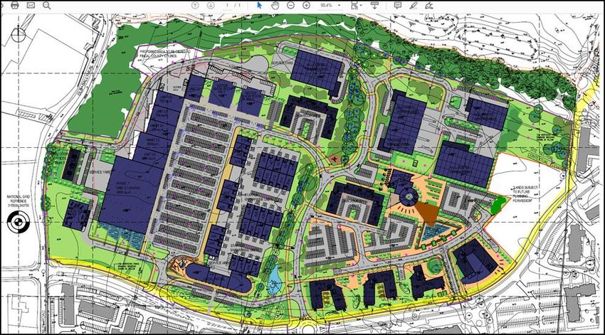
STATEMENT OF CONSISTENCY

1           INTRODUCTION
1.1         Proposed Development
Cosgrave Developments (the Applicant) is seeking planning permission for development on lands within the
former Santry Demesne, north of Northwood Avenue adjacent to existing retail, residential and commercial
lands.
The proposed development will consist of the construction of:
•    4 no. 7-storey plus penthouse apartment (8-storey) blocks containing 331 no. apartment units
     comprising: 6 no. one bedroom units, 292 no. two bedroom units and 33 no. three bedroom units over a
     shared basement;
•    334 no. associated car parking spaces at basement level, 4 no. surface car parking spaces and 760 no
     bicycle parking spaces;
•    5 no. ground floor mixed-use commercial units (intended to accommodate Class 1, 2 and 8, café,
     restaurant uses) within Blocks B and C with a total area of c. 939sq.m.;
•    Shared residential services to include a multi-function area (c. 133sq.m.), a gym (c. 140sq.m.) and
     concierge (81.5 sq.m) within Block A.
•    A childcare facility (c. 224sq.m.) within Block C.
•    Associated landscaping, public open space, pedestrian and cycle paths, ESB substation, utilities
     connections and services.

1.2         Statement of Consistency
RPS Group Ltd. has been commissioned by Cosgrave Developments to prepare this Planning Report and
Statement of Consistency in relation to the proposed Strategic Housing Development (SHD) at lands off
Northwood Avenue, Santry, Dublin 9, County Dublin.
Section 8 of the Planning and Development (Housing) and Residential Tenancies Act 2016, as amended,
(the Act) outlines the requirements relating to SHD planning applications and states that applications must
be accompanied by a statement which includes the following:
“(iv) (I) setting out how the proposal will be consistent with the objectives of the relevant development plan or
local area plan, and
(iv) (II) where the proposed development materially contravenes the said plan other than in relation to the
zoning of the land, indicating why permission should, nonetheless, be granted, having regard to a
consideration specified in section 37(2)(b) of the Act of 2000”.
In accordance with item (iv)(I) above, this Statement of Consistency illustrates how the proposed development
will be consistent with the policies, objectives, land use zoning and development standards set out in the Fingal
Development Plan 2017-2023 and other planning policy documents and guidelines, as appropriate. This
Statement of Consistency also provides further details in relation to the site location and context, development
description and relevant planning history.
As the proposed development will be consistent with the zoning of the subject lands, a material contravention
statement, as referred to in item (iv)(II) above, is not required in this instance.

1.3         Format of Report
This Planning Report and Statement of Consistency is arranged under the following headings:
•    Section 1:        Introduction

MH18062 | Strategic Housing Development Blackwood Square | F001 | 2nd December 2019
rpsgroup.com                                                                                               Page 1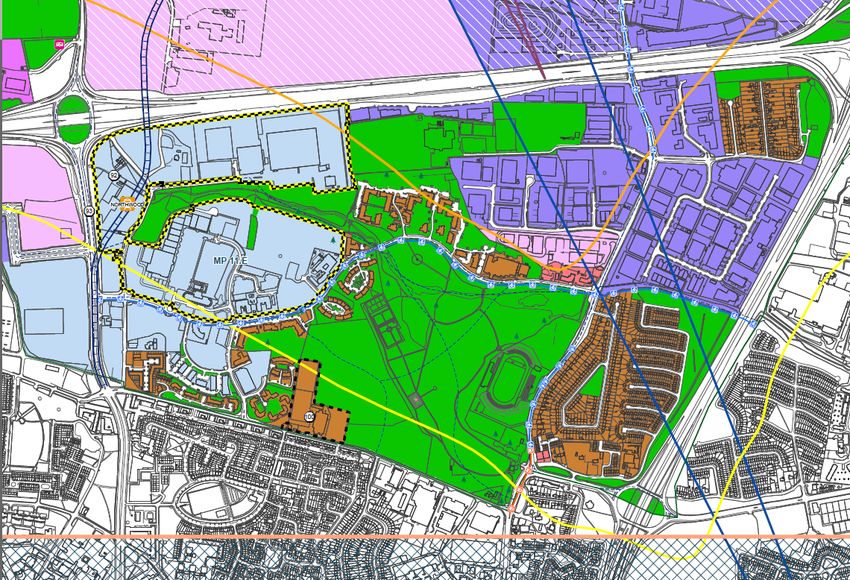
STATEMENT OF CONSISTENCY

•       Section 2:      Site Location and Urban Context
•       Section 3:      Planning History
•       Section 4:      Description of Proposed Development
•       Section 5:      Rationale
•       Section 6:      Environmental Appraisals
•       Section 7:      National, Regional and Local Planning Policy and Guidelines
•       Section 8:      Compliance with Part V
•       Section 9:      Conclusion.

2                SITE LOCATION AND URBAN CONTEXT
The subject site is located within the former Santry Demesne c. 7km from Dublin city centre. The proposed
MetroLink Northwood Stop is to be located c. 350m to the west of the subject site. The site is bounded to the
north by residential development which is currently under construction (Reg. Ref. F15A/0440 as modified)
and to the west by existing car parking associated with Gulliver’s Retail Park. The site is bound to the east by
an internal roadway and beyond that car parking associated with Swift Square Office Park office and housing
under construction (Reg. Ref. F15A/0440 as modified). The site is bound to the south by a McDonald’s fast
food restaurant and Gulliver’s Local Retail Centre.
Further to the south of the subject site is Northwood Avenue. The M50 is approximately 500m to the north.
The southern portion of the site currently consists primarily of a greenfield area. The northern portion of the
site comprises of a temporary surface car park for construction workers at the adjacent residential
development. There is a row of trees on the eastern boundary of the site associated with former field
boundaries. The location and immediate context of the subject site is illustrated in Figure 2-1.

                                                                   Bridgefield &
                                                                   Pappan Grove
                                 Gulliver’s Retail               Under Construction
                                       Park
                                                                                Cedarview Housing                      TLC Centre
                                                                                Under Construction                    Nursing Home

                                                                                                     Sports Surgery
                                                                                                         Clinic

                                          McDonalds Drive
      Proposed                                Thru
    MetroLink Stop                         Local Centre
                                                                      Swift Square
                                                                       Office Park
                     Under Construction

                                              The Crescent
                                             Building Offices

                                                Northwood Business Campus

Figure 2-1: Site Location (indicative subject lands outlined in red)
Source: Open Street Map and RPS annotation
The surrounding lands have been subject to significant land use change over the last 15 years. The
Applicant has developed Gulliver’s Retail Park, Gulliver’s Local Centre and part of Swift Square Office Park

MH18062 | Strategic Housing Development Blackwood Square | F001 | 2nd December 2019
rpsgroup.com                                                                                                                         Page 2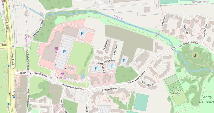
STATEMENT OF CONSISTENCY

in the immediate vicinity of the subject site and is currently completing adjacent residential development to
the north (Bridgefield and Pappan Grove) and to the east (Cedarview) permitted under Reg. Ref. F15A/0440,
as amended, some of which will be occupied later this year.
Gulliver’s Retail Park accommodates Lidl, Home Base, Home Focus, Petmania, Mr. Price and a number of
furniture stores. Gulliver’s Local Centre accommodates Spar, Costa Coffee, a chemist, hair and beauty
salon and other local shops.
To the east of the site is the Sports Surgery Clinic and TLC Centre Nursing Home. To the south of
Northwood Avenue in the immediate vicinity of the subject site are The Crescent Building office complex,
Northwood Business Campus, Lymewood Mews Apartments and recreational parkland and grounds in
Santry Park. Other sites along Northwood Avenue are under construction
There are good quality pedestrian walkways on all the major links locally including dedicated pedestrian
crossing facilities at the signalised junctions in the area. Along the length of Northwood Avenue adjacent to
the Sports Surgery Clinic there are footpaths on both sides of the road and an off-road cycle track.
The site benefits from its location near to a number of high frequency bus services. Stops located on the
R108, approximately 350m from the site are served by routes 4, 155, 42d, 17a and 13.
The National Transport Authority is progressing the Bus Connects project. This includes Core Bus Corridors
which shall provide higher frequency and capacity bus services including measures such as dedicated lanes,
higher quality stops, off-board ticketing and full priority at traffic signals. The proposed Ballymun to City
Centre Core Bus Corridor Route, which runs along the R102 approximately 700m to the southwest of the
site. Bus Connects also provides for the redesign of the bus network and includes plans for bus services at a
frequency of 1 every 10 – 15 minutes at midday serving Northwood Avenue.
MetroLink will provide a new rail line to link between Swords and Charlemont in Dublin City Centre. The
Preferred Route has been published. The location of the planned Northwood Station is approximately 350m
from the subject site at the Northwood Avenue / R108 junction.
The Metro will be similar to the Luas in operation but will enjoy complete priority along its route, allowing for
increased frequency of service with a tram expected every 2 minutes during peak periods. Services are
scheduled to commence in 2027. The preferred route and station can be seen in Figure 2-2.

                                                                                      Subject Site

Figure 2-2: MetroLink Preferred Route
Source: NTA

MH18062 | Strategic Housing Development Blackwood Square | F001 | 2nd December 2019
rpsgroup.com                                                                                                 Page 3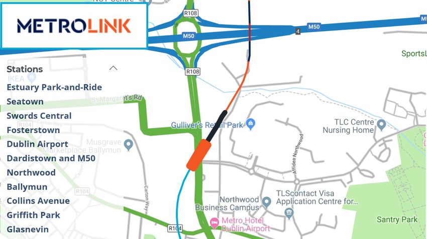
STATEMENT OF CONSISTENCY

The site is located within a developing mixed-use community which will benefit from excellent metro and bus
public transport linkages.

3           PLANNING HISTORY
A desktop review of the planning history for the subject lands and its immediate surroundings was
undertaken using Fingal County Council’s online planning search facility. A summary of the relevant planning
history is set out herein. Any concerns or issues identified pertinent to the subject application have been
considered in the design process and are addressed in so far as is possible.

3.1         SUBJECT LANDS
The site forms part of a larger Master Plan area of 19.8ha on which planning permission was granted for a
mixed-use development in 2005 under Reg. Ref. F04A/1562. The appropriate period for this consent has
been extended to 2020 under Reg. Ref. F04A/1562/E2. The permitted Master Plan comprised modern
business, enterprise and commercial facilities consisting of c. 77,016 sq. m. Completed elements of the
Master Plan include a retail park (Gulliver’s Retail Park), 2 no. of the 4 no. business units (Swift Square
Office Park) and the Local Centre. The context of the site within the Master Plan is illustrated in Figure 3-1
for information purposes.

                                                                               Subject Site

Figure 3-1: Permitted Masterplan with Indicative Site Location in red (Reg. Ref. F04A/1562)
Source: Cosgrave Developments
The overall permitted Master Plan consisted of:
•    5 no. logistic warehouses on single level each with ancillary office space on two levels of c. 11,126 sq.
     m. in total;
•    35 no. two storey enterprise starter units totalling c. 12,250 sq. m.;
•    4 no. five storey office blocks;
•    28 no. three storey own door office buildings totalling c. 11,172 sq. m.;
•    7 no. single storey retail warehouse units totalling c. 10,500 sq. m.;

MH18062 | Strategic Housing Development Blackwood Square | F001 | 2nd December 2019
rpsgroup.com                                                                                              Page 4
STATEMENT OF CONSISTENCY

•    Single storey Local Centre comprising 5 no. units totalling c. 1,670 sq. m.;
•    3 no. two storey motor showrooms totalling c. 3,568 sq. m.;
•    1 no. two storey amenity building totalling c. 1,700 sq. m.;
•    1,926 no. car parking spaces (838 no. car parking spaces to serve office units, 477 no.
•    below surface and 361 no. temporary surface car parking spaces;
•    An additional 1,088 no. surface car parking spaces to serve the remainder of the
•    development; and
•    Ancillary office, administration and staff facilities for all proposed buildings.
The Master Plan also proposed a network of internal roads; a new junction off the old Ballymun Road; 3 no.
new junctions off the new Santry Demesne distributor road; reconfiguration of the Santry Demesne
distributor road to accommodate deceleration and turning lanes; a new roundabout to aid access into the site
and facilitate site junction works; drainage and water supply; utilities; landscaping works; fencing and
boundary treatment; security hut; road lighting; and; signage.
Amendments to this parent planning permission, with respect to Gulliver’s Retail Park and Swift Square
Office Park to facilitate tenant requirements, have been granted and implemented.
A five storey office building with a height of 79m and an area of c.7,221sq.m to the east of the existing Swift
Square office buildings 1 and 2 was permitted on 24th May 2017 (Reg. Ref. F16A/0514). This permission
has not been implemented.
Residential development within an area of the Masterplan was permitted under Reg. Ref. F15A/0440
replacing 5 no. logistic warehouses (11,126 sq.m), 23 no. 3 storey own door office buildings (9,696 sq.m), 1
no. amenity building (1,700 sq.m) and associated car parking. This development consisted of 374 no.
residential units comprising apartments buildings over a shared basement, houses, a childcare facility and
associated open spaces on a c.7.0 ha site. This permission was modified by F16A/0572 resulting in the
provision of 5 no. additional apartment units and again under F17A/0371 which comprised amendments to
104 no. house units. The most recent permission (Reg. Ref. F18A/0205) provided for the omission of 24 no.
houses (Unit Nos. 105 – 128) and revision of boundary treatments permitted under Reg. Ref. F15A/0440 to
define the new eastern boundary of the subject site with the Sports Surgery Clinic. Construction of the
355no. units permitted is currently close to completion and is referred to as Bridgefield, Pappangrove and
Cedar View.

3.2         ADJACENT LANDS
The surrounding lands have a very extensive planning history and there has been significant development
over the last 15 years. The following planning permissions relate to recent application on lands proximate to
the subject lands.
Figure 3-2 identifies the location of each planning application listed in this section with their corresponding
planning register reference.

MH18062 | Strategic Housing Development Blackwood Square | F001 | 2nd December 2019
rpsgroup.com                                                                                                Page 5
STATEMENT OF CONSISTENCY

                                                                                      F15A/0440

                Subject Site                                                                  F18A/0675 &
                                                                                              F19A/0004

       F18A/0421

                                                                            F16A/0514

    F18A/0343                                         F18A/0438

Figure 3-2: Adjacent Planning Applications
Source: Google Maps, RPS Annotation
•    Reg. Ref. F18A/0421: Planning permission was granted on 7th March 2019 for a mixed use residential
     scheme comprising 99no. apartments, concierge, creche, residents lounge and meeting rooms on lands
     approximately 180m to the southwest of the subject site, south of Northwood Avenue.
•    Reg. Ref. F18A/0438: Planning permission was granted on 16th April 2019 for a mixed use
     development comprising 2no. 6 storey blocks containing 99no. apartments in total, four storey office
     building (c.2,536 sq.m) and other associated development. The application forms phase 2 of the
     development permitted under Reg. Ref. F18A/0421 and is located approximately 180m to the southwest
     of the subject site, south of Northwood Avenue.
•    Reg. Ref. F19A/0004: A final grant was issued on 12th July 2019 for an extension to the Sports Surgery
     Clinic including 2 no. operating theatres and 4 no. intensive care units.
•    Reg. Ref. F18A/0675: A final grant split decision was issued on 16th July 2019 for retention and
     permission for additional surface car parking, retention of 3 no. storage sheds and permission for a new
     store building at the Sports Surgery Clinic.
•    Reg. Ref. F18A/0343: Planning permission was granted on 17th September 2018 for amendment to
     previously approved planning permission F17A/0207 and F15A/0054. The proposed amendments
     consisted of the provision of a 3-bedroom apartment at fourth floor level Core 2, in lieu of permitted
     arrangement of a 2-bedroom apartment and plantroom. The new proposed mix will consist of 4 No. one
     bed units, 23 no. two bed units and 3 no. three bed units. The works also include minor elevational
     changes.

MH18062 | Strategic Housing Development Blackwood Square | F001 | 2nd December 2019
rpsgroup.com                                                                                                Page 6
STATEMENT OF CONSISTENCY
4 DESCRIPTION OF PROPOSED DEVELOPMENT
4.1 Proposed Development
The proposed development comprises of 4 no. apartment blocks arranged around an internal courtyard over
a shared basement. A description of each block is set out below:
• Block A comprises 88 no. units (2 no. one bedroom units, 63 no. two bedroom units and 23 no. three
bedroom units).
• Block B comprises 77 no. units (70 no. two bedroom units and 7 no. three bedroom units).
• Block C comprises 77 no. units (76 no. two bedroom units and 1 no. three bedroom units).
• Block D comprises 89 no. units (4 no. one bedroom units, 83 no. two bedroom units and 2 no. three
bedroom units).
Each of the apartment blocks are 7 no. storeys plus penthouse (8-storeys).
The proposed development will also include the provision of a childcare facility and 5 no. mixed use
commercial units which may accommodate a range of Class 1, 2 and 8, café, restaurant uses at ground floor
within Blocks B and C (c. 939 sq.m). These units will address and animate pedestrian routes and existing
retail development in the environs.
Ancillary resident facilities include communal open space, concierge, multi-function room area and gym are
also provided at ground floor level.
Secured resident bicycle parking spaces comprising 690 no. are provided at basement level and an
additional 70 no. bicycle parking spaces are provided at surface level.
Resident car parking is comprised of 331 no. car parking spaces and 3 no. disabled spaces at basement
level. Visitor car parking shall be facilitated through shared used of existing surface level car parking spaces
associated with the adjoining retail park and local centre. A letter for Cosgrave Property Group is attached in
this regard. In addition to the disabled car parking spaces at basement level, 1 no. disabled car parking
space will be allocated at surface level. 3 no. car club spaces shall also be allocated at surface level.
Landscaping and boundary treatments including a new east-west pedestrian/cyclist route linking to existing
and planned public transport services is proposed. A north-south pedestrian cycle route is also proposed
linking with the pedestrian route through the residential development to the north and providing connectivity
with the Santry River Amenity Walk.
For further detail on the physical characteristics of the proposed development please refer to the
architectural drawings, design statement and the landscape drawings which accompany this submission.
4.2 Key Site Statistics
The principal details of the proposed development are as follows:
• Red Line Boundary 21,191m2
• Apartments 331 no. apartments
• Childcare Facility 224 sq.m
• Mixed Use Commercial Units 939 sq.m
(Class 1, 2 and 8, café, restaurant uses)
• Resident services: Gym 140 sq.m
Multi-Function Area 133 sq.m
Concierge 81.5 sq.m
• Car Parking 331 no. spaces + 4 disabled
• Car share spaces 3 no. spaces
• Childcare short term parking 5 no. spaces
MH18062 | Strategic Housing Development Blackwood Square | F001 | 2nd December 2019
rpsgroup.com Page 7STATEMENT OF CONSISTENCY
• Bicycle Parking 690 no. spaces (basement) + 70 (surface)
• Motorbike Parking 5 no. spaces
• Public Open Space 4,672 sq.m (including 650sq.m play area)
• Private Open Space 3,671 sq.m (including 152sq.m play area)
• Public Realm including route to Metrolink 5,255 sq.m
4.3 Residential
The development will include the construction of 4 no. apartment blocks with a combined total of 331 no.
apartment units. A summary of unit sizes within each block is provided in Table 4-1.
Table 4-1: Development Schedule
Schedule of Apartment Units and Areas
Block A No. of Units Area
1 Bed 2 50.0 – 70.7sq.m
2 Bed 63 81 - 100.8sq.m
3 Bed 23 99 – 121sq.m
Residential Concierge 81.5sq.m
Multi-function Area 133sq.m
GYM 140sq.m
Block B No. of Units Area
2 Bed 70 80 – 91sq.m
3 Bed 7 105 - 119sq.m
Unit A 239sq.m
Unit B 216sq.m
Unit C 102sq.m
Block C No. of Units Area
2 Bed 76 80 – 110sq.m
3 Bed 1 105 sq.m
Creche 321sq.m
Unit D 140sq.m
Unit E 242sq.m
Block D No. of Units Area
1 Bed 4 50 – 57.5sq.m
2 Bed 83 76 – 99sq.m
3 Bed 2 107 – 110sq.m
Basement Area: 10,150sq.m
Open Space: Area
Courtyard Private Open Space 3,196sq.m + 475sq.m =
& Periphery Gardens 3,671sq.m
Including 152sq.m play area
Public Open Space to east and 4,672sq.m Including 650sq.m
south play area
Public Realm 5,255sq.m
Parking: Spaces:
Standard Parking 331 spaces
Disabled Parking 4 space
Car sharing spaces 3 spaces
MH18062 | Strategic Housing Development Blackwood Square | F001 | 2nd December 2019
rpsgroup.com Page 8STATEMENT OF CONSISTENCY
Schedule of Apartment Units and Areas
Bicycle parking – basement 690 spaces
level
Bicycle parking – surface level 70 spaces
Source: Architect’s Schedules
Further details on proposed apartments is set out in the Housing Quality Assessment prepared by
McCrossan O’Rourke Manning Architects and enclosed as part of the application package.
4.4 Commercial Units
The proposed development also includes provision of a mix of street level units (Class 1, 2 and 8, café,
restaurant uses) along the southern and western boundaries adjacent to the existing neighbourhood centre,
next to the proposed pedestrian/cycle route to the planned Northwood Metro Station and addressing existing
retail development in the area. The provision of these uses along this frontage provide for increased activity
at ground level and increases the level of animation along the frontage. The provision of these uses at
ground level provide for additional amenity to the future and existing residents in the area.
The 5 no. units comprise:
• Unit 1 - Block B 239 sq.m
• Unit 2 - Block B 216 sq.m
• Unit 3 - Block B 102 sq.m
• Unit 4 - Block C 140 sq.m
• Unit 5- Block C 242 sq.m
Childcare Facility
Unit 5
Unit 4
Unit 3
Unit 2
Unit 1 Concierge
Multi Function
Gym
Figure 4-1: Active Uses Addressing Existing Development
Source: Architect’s Drawings
MH18062 | Strategic Housing Development Blackwood Square | F001 | 2nd December 2019
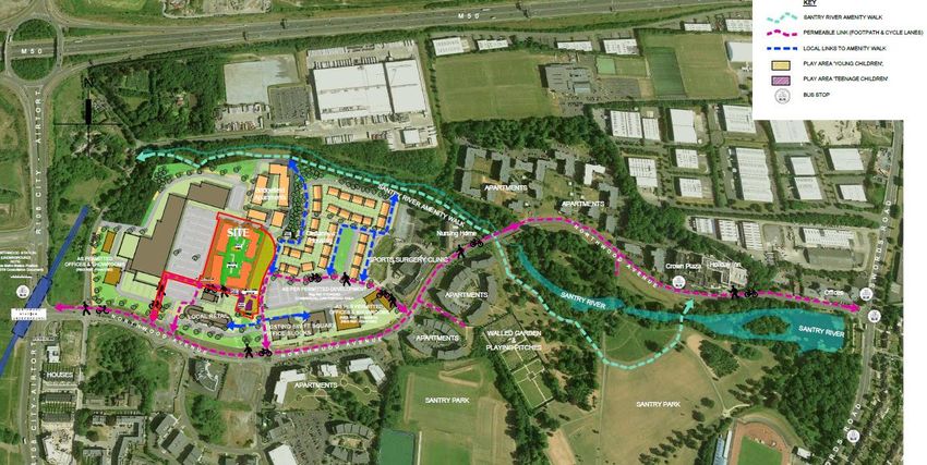
rpsgroup.com Page 9STATEMENT OF CONSISTENCY The uses within the ground level units will all be capable of accommodating of a mix of class 1, class 2, class 8, café/deli and restaurant uses. It is proposed that the first use within each of the units will be agreed with the planning authority prior to occupancy with the exempted development planning regulations commencement on all changes of uses thereafter. In this regard the landscaping proposals have been formulated with flexibility in mind to ensure that those areas capable optimising aspect and position will be provided with seating to facilitated passive leisure or spill out areas associated with any prospective café type use. 4.5 Childcare Facility A childcare facility of 224sq.m is to be provided in the ground floor of Block C in the northwest of the site. This facility can accommodate 48 no. places as derived from the Childcare Demand Analysis prepared by RPS which forms part the application documentation. This analysis was informed by policy, existing and proposed childcare provision and the unit mix proposed. This facility includes a dedicated area of private open space for the use of staff and children and is also proximate to the proposed playground within the courtyard. A drop off area directly adjacent to the facility is proposed. 4.6 Access and Connectivity The proposed development includes a walking and cycling route ‘green route’. The green route proposed aims to provide links from the existing development to the north of the proposed development through the existing protected trees and from the east of the site providing a green route across the existing car park and eventually linking to the existing cycle track and footpath on Northwood Avenue and thereby providing access to the planned Northwood Metro Link station. This route will also link the proposed development with the Santry River Amenity Walk. The main cycling and pedestrian access point will be running east-west and located to the south of the site. This will provide connectivity with wider development within Santry Demesne and a future Northwood metro stop. There will also be a north-south pedestrian / cycle route running from Northwood Avenue to the Santry River Amenity Walk. Vehicular access to the proposed residential scheme will be via Northwood Avenue. An existing roundabout shall provide access to the basement car park. Figure 4-2: Open Space and Sustainable Connectivity Source: Architect’s Drawings MH18062 | Strategic Housing Development Blackwood Square | F001 | 2nd December 2019 rpsgroup.com Page 10
STATEMENT OF CONSISTENCY

4.7         Open Space and Landscaping
As illustrated on Figure 4-2 the open space and landscape strategy for the proposed development seeks to
integrate the new development with development under construction and with the existing landscape
character of the area to create attractive, usable and linked open spaces. The public areas are designed as
landscape spaces and green links that offer the opportunity for meeting, walking, formal and informal play.
In this regard the proposed landscape scheme seeks to:
•    Create an attractive, high quality landscape for future residents and has been designed to integrate the
     development into the surrounding environment.
•    Establish a clear distinction between public and private spaces and ensures that public areas are
     suitably supervised by adjacent buildings.
•    Provide high quality linkages for pedestrians and cyclists to the planned Northwood Metro Link station
     and the Santry River Amenity Walk.
•    Address the adjacent retail areas to the south and west.
•    Protect existing treeline, which will enhance biodiversity and visual interest.
•    Incorporated, where possible, mature and healthy trees on the eastern boundary into the overall design.

Green Routes
Pedestrian/cycle routes are proposed to link into those routes already created along Northwood Avenue and
those under construction as part of Ref. Ref. F15A/0440 between Cedarview and Swift Square Office Park.
The proposed development seeks to continue this route westwards and on towards the proposed location for
the Metrolink stop. The final alignment of this route may change as proposals for the Metro are finalised.
The proposed development also includes a sylvan north-south route along its eastern boundary which will
provide a connection between the site northwards onto the Santry River Amenity Walk and southward onto
Northwood Avenue.

Public Realm
A new public realm is created along the western façade of the building within which it is proposed to locate
grass tables with seating areas and tree planting. These spaces have been designed to enable outdoor
dining, if desired, but can also provide informal seating not necessarily directly associated with adjoining
units but as generally providing civic amenity. A formal hedge is proposed as a buffer between this space
and the car parking providing the space with some enclosure and contributing towards creating a
comfortable urban street space within which to dwell.

Play
A cluster interconnected play areas extending to an area of c.650 sq.m for older children is provided to the
southeast of Block A. Further details are provided in the landscape masterplan for the site prepared by Kevin
Fitzpatrick Landscape Architecture.

Communal Courtyard
The communal courtyard will provide a range of open spaces for use by the residents. Secluded seating
areas are provided for individuals or small groupings while other spaces to cater for larger groups for
communal uses are also integrated into the proposed landscape design. Planting has been designed to
create buffers and visual screens between the circulation paths, seating areas and private terraces.
A playground for young children is proposed within the internal courtyard. The proposed play space
comprises c.152 sq.m and is passively surveyed by proposed apartments. Further details are provided in the
landscape masterplan for the site.

MH18062 | Strategic Housing Development Blackwood Square | F001 | 2nd December 2019
rpsgroup.com                                                                                             Page 11
STATEMENT OF CONSISTENCY Lighting proposals for the overall site prepared by McElligott Engineers also form part of the submission. Detail in relation to the proposed open space provision and proposed play spaces is contained in the Landscape Report and Outline Landscape Specification and associated drawings prepared by Kevin Fitzpatrick Landscape Architecture and are submitted as part of the submission. These landscape plans include hard and soft landscaping for the private and communal amenity spaces, boundary approach and planting programme. As requested by the Parks Department during pre-application consultations, the suite of landscaping plans also includes a drawing co-ordinated by Kevin Fitzpatrick Landscape Architecture illustrating the proposed landscape measures together with utility and lighting proposals. 4.8 Parking Cycle Parking The proposed development will provide 690 no. resident bicycle parking spaces in bicycle store areas within the basement. These stores will provide for the secure storage of bicycles with access restricted to residents only. The storage areas are located in close proximity to the apartment entrances to ensure ease of access and convenience for apartment residents. A further 70 no. bicycle spaces are provided in the form of open air bike rails, outside each apartment block, particularly proximate to retail units. These are spread across the apartment blocks for convenience and will be suitably overlooked for passive surveillance. Car Parking The proposed development will include a total of 338 no. car parking spaces (including 4 no. disabled car parking and 3 no. car club sharing spaces). Each apartment will have one dedicated car parking space. In order to support sustainable use of private vehicular transport provision shall be made for electric vehicle spaces with charging facilities. All car parking spaces shall be ducted to allow for future provision of electric charging. A Multiple Occupancy Building Car Charging Strategy prepared by McElligott Engineers is included as part of the planning application documentation and sets out the rationale for the nature, extent, further provision and management of car charging facilities which accord with policy and SEAI grant incentives. To further support sustainable transport patterns 3 no. spaces for short term car club rental are proposed. These are located at surface level proximate to the proposed commercial units and adjacent to the pedestrian route connecting the subject site to the planned Northwood Metro Link station. 1 no. of the disabled car parking space will also be provided at this location. The provision of resident car parking spaces within the basement ensures that surface car parking within the subject site is minimised with spaces around the proposed apartment blocks instead forming part of the designed landscape. Visitor parking and any car park demand generated by the local commercial units shall be facilitated by the use of existing car parking immediately to the west of the subject site associated with the existing retail park and local centre. A letter is attached from Cosgrave Property Group in this regard. This shared usage of car parking spaces represents a prudent and sustainable approach to car parking provision. 4.9 Site Services Lighting The application proposes street lighting throughout the residential development as an integral part of the scheme. The lighting plan has been designed in accordance with the Fingal Development Plan 2017-2023 (see Section 7.1.16), providing a level of brightness that will minimise incidences of light spillage or pollution on the neighbouring residential developments and biodiversity in the surrounding area. Detailed lighting MH18062 | Strategic Housing Development Blackwood Square | F001 | 2nd December 2019 rpsgroup.com Page 12
STATEMENT OF CONSISTENCY

proposals are set out in the Public Lighting Report and associated drawings prepared by McElligott
Consulting Engineers and enclosed as part of this submission.

Refuse Bins
Communal bins shall be provided for the proposed apartment units. These will be located within the
basement, ensuring proximity for residents and minimisation of visual impact and surface clutter. This level
of bin storage has been designed to ensure sufficient space for refuse storage based on the projected levels
of waste generation.
A separate provision for commercial/retail tenants is proposed at surface level between blocks B and C. This
shall be appropriately screened and is located proximate to the collection point.
Further details are set out in the Waste Management Plan prepared by Keywaste and the Architect’s Design
Statement prepared by McCrossan O’Rourke Manning Architects enclosed as part of this submission.

ESB Substation
A double substation is required to support the proposed development and future level of car charging
facilities. The requirements of the ESB in this regard are set out in the Energy Statement prepared by
McElligott Engineers. A design rationale for the location of the utility is set out in the Architect’s Design
Statement prepared by McCrossan O’Rourke Manning Architects.

Flood Risk Assessment
A Flood Risk Assessment prepared by J.B. Barry & Partners Consulting Engineers is included within the
submission. The assessment concludes that the PFRA flood extent map and FCC SFRA Flood Map
indicates that the existing site lies within Flood Zone C. The CFRAMS fluvial flood extent maps indicates that
the site lies within Flood Zone C, and hence is at low risk of flooding.

4.10 Visual Impact
The site is not visible from locations in the wider landscape due to the flat nature of the topography, the scale
of the local built development and the significant number of trees in the area. Locally the site is most visually
prominent from the local access roads. A Landscape and Visual Impact Assessment together with Verified
Views forms part of the EIAR submitted with this planning application. A series of computer generated
images (CGI) prepared by Archimedium are also included as part of the planning application documentation.

4.11 Materials and Finishes
Finishes and materials will ensure consistency with existing surrounding developments including the housing
scheme to the north and wider development within Santry Demesne (currently under construction).
The proposed buildings employ a controlled palette of materials. It is envisaged that the brickwork will match
or be similar in character to that of the adjacent Bridgefield apartments, a soft muted buff. Window, balcony
and cladding material and detail will also carry through from Bridgefield.
Continuous vertical planes of bay windows will contrast with and visually break the general brickwork – taut
technical planes set against the warm buff masonry.
The top floor of each building is clad with glazed curtain walling which allows the buildings to read as 7
storeys of masonry with a visually and materially lighter sky reflecting attic storey over. Balconies at this level
will be punched into the curtain walled volume, retaining a clean un-broken parapet line
Further details in relation to the proposed materials and finishes are provided in the Architect’s Design
Statement prepared by McCrossan O’Rourke Manning Architects and enclosed as part of this submission.

MH18062 | Strategic Housing Development Blackwood Square | F001 | 2nd December 2019
rpsgroup.com                                                                                                    Page 13
STATEMENT OF CONSISTENCY

4.12 Integration with Existing Area
The proposed development has been designed in response to the existing site context and development in
the area. High quality pedestrian / cycle linkages with the surrounding environment in Northwood and
adjacent including the Santry River Amenity Walk and the planned Northwood Metro Link station.
The scheme seeks to promote active uses along the southern and western frontages. These will address
existing retail development in the immediate vicinity and will benefit from the creation of a new public realm
along the western boundary thereby enabling uses to extend their function onto the street edge.
A priority in the design of the subject development has been the protection and retention of the treeline on
the east of the site. As detailed in the enclosed Aboricultural Report undertaken by The Tree File Ltd all trees
within the site are to be retained and are fully incorporated into the landscape design.

5           RATIONALE
Dublin is experiencing a housing crisis with house prices and rents that continue to increase, making it more
difficult and more expensive for people to live reasonably close to employment and social / community
facilities. Dublin is one of the least affordable cities to live in with mortgages accounting for over 25% of the
average household income, and the average rent now at €1,875 per month. The housing crisis presents
significant social and economic challenges and it is feared that the undersupply and subsequent cost of
housing may hinder Dublin and Ireland’s economic growth and social cohesiveness.
The National Planning Framework (see Section 7.1 of this Statement of Consistency) is planning for
490,000 – 540,000 additional people in the Eastern and Midland Region. This equates to a total population
of around 2.85 million people. In accordance with national and regional policies and objectives, this
anticipated growth must be accommodated through sustainable development, with high quality residential
development provided within the city’s development boundary to ensure a compact urban form, reduce
commuting times and maximise the viability of public transport options. Residential developments should
also be located in close proximity to existing services and facilities including retail and employment areas
and schools. (The proposed development’s consistency with national and regional planning policies and
objectives are detailed in Section 7 of this Statement of Consistency).
The subject site is easily accessed via the R108, R104 and the M50 and is close to a good range of
supporting services within Santry and Ballymun including schools, community facilities, local services and
retail uses. The site is located near a number of existing and expanding employment areas including Swift
Square Office Park, Northwood Business Campus and Sport Surgery Clinic within Northwood, Dublin Airport,
GE zoned lands just north of the M50 while also remaining convenient to the city centre.
There is a range of existing and planned public transport and pedestrian/cycleways in the area which will
ensure the proposed development is well connected and accessible. The delivery of Bus Connects including
the Ballymun to City Centre Core Bus Corridor and the Swords to City Centre Core Bus Corridor and the
MetroLink will further enhance public transport provision in the vicinity of the subject site in the medium term.
Having regard to the above, it is submitted that the subject site represents an ideal opportunity to provide a
new strategically located residential development on an appropriately zoned site within Dublin’s M50 ring.

MH18062 | Strategic Housing Development Blackwood Square | F001 | 2nd December 2019
rpsgroup.com                                                                                                Page 14
STATEMENT OF CONSISTENCY

6           ENVIRONMENTAL APPRAISALS
6.1         Environmental Impact Assessment Report
The obligations under Directive 2014/52/EU have been transposed into Irish law pursuant to the European
Union (Planning and Development) (Environmental Impact Assessment) Regulations (S.I No. 296 of 2018).
The regulations specify the developments for which EIA will be required and the information that must be
provided in an EIAR prepared in connection with the subject project.
Screening is the term used to describe the process for determining whether a proposed development
requires an EIA by reference to mandatory legislative threshold requirements or by reference to the type and
scale of the proposed development and the significance or the environmental sensitivity of the receiving
baseline environment.
The proposal has been screened by reference to the Planning and Development Act 2000, as amended, and
the Planning and Development Regulations 2001, as amended.
The proposed development is a category 10 “infrastructure projects” of Part 2 of Schedule 5 of the Planning
and Development Regulations 2001, as amended but does not exceed the category 10(b)(i) threshold
“Construction of more than 500 dwelling units” but does align with category 13 “changes, extensions,
development and testing” which includes:
       “(a) Any change or extension of development already authorised, executed or in the
       process of being executed (not being a change or extension referred to in Part 1) which
       would:-
       (i) result in the development being of a class listed in Part 1 or paragraphs 1 to 12 of Part
       2 of this Schedule, and
       (ii) result in an increase in size greater than –
       - 25 per cent, or
       - an amount equal to 50 per cent of the appropriate threshold, whichever is the greater.”
For clarity, the subject development in isolation does not fall within development classes set out in Part 1 or
Class 10(b)(i) of Part 2 of Schedule 5. However, the subject development is located adjacent to a residential
development which is currently under construction by the applicant. Permission for 374 no. residential units
on a 7.0 hectare site under Reg. Ref. F15A/0440 was modified by F16A/0572, F17A/0371 and F18A/0205
resulting in the overall provision of 355no. residential units which are now almost complete.
It has therefore been determined that the quantum of development now proposed in addition to the adjacent
permitted residential development would exceed the relevant threshold and that an EIA should therefore be
undertaken to cover the direct effects and any indirect, secondary, cumulative, transboundary, short-term,
medium-term and long-term, permanent and temporary, positive and negative effects of the proposed
development.
An Environmental Impact Assessment Report (EIAR) has being prepared and is set out in 3 no. volumes as
follows:
•    Vol. 1 - Non-Technical Summary
•    Vol. 2 - Main Document
•    Vol. 3 – Appendices Part A and Part B
This EIAR accompanies the planning application.

6.2         Appropriate Assessment Screening Report
An Appropriate Assessment Screening Report has been prepared by Scott Cawley and is enclosed as part
SHD application. The Appropriate Assessment Screening Report documents evaluation and analysis

MH18062 | Strategic Housing Development Blackwood Square | F001 | 2nd December 2019
rpsgroup.com                                                                                             Page 15
STATEMENT OF CONSISTENCY
seeking to establish whether or not a decision to grant planning permission for the proposed demolition
works is likely to have a significant effect on any designated European Site under European Council
Directives 92/43/EEC and 2009/147/EC.
The exercise considers the proposed works individually and in combination with other relevant plans or
projects, and has been undertaken in view of best scientific knowledge and in view of the conservation
objectives of the subject site.
The Appropriate Assessment Screening Report concludes that the proposed development is not directly
connected with or necessary to the management of any designated European Site. The proposed
development will not give rise to potential significant effects on the Qualifying Interests or Special
Conservation Interests of any European Site and will not give rise to potential in‐combination or cumulative
effects with the other projects considered.
7 PLANNING POLICY – STATEMENT OF
CONSISTENCY
7.1 Introduction
The Irish Planning System is outlined schematically in Figure 7.1. The relevant planning policies are set out
for each level within the hierarchy in the sections that follow.
Figure 7-1: Irish Planning Hierarchy
Source: NPF
MH18062 | Strategic Housing Development Blackwood Square | F001 | 2nd December 2019
rpsgroup.com Page 16STATEMENT OF CONSISTENCY
The key provisions of national and regional planning policy as they relate to the proposed development are
set out in the following sections. The key policy documents of relevance to the proposed development are as
follows:
• National
– Project Ireland 2040 – National Planning Framework;
– Rebuilding Ireland – Action Plan for Housing and Homelessness;
– Guidelines for Planning Authorities on Sustainable Residential Development in Urban Areas
(2009);
– Sustainable Urban Housing: Design Standards for New Apartments, Guidelines for Planning
Authorities 2018;
– Design Manual for Urban Roads and Streets 2013;
– Urban Design Manual – A Best Practice Guide, 2009;
– Urban Development and Building Heights – Guidelines for Planning Authorities, 2018;
– Guidelines for Planning Authorities on Childcare Facilities, 2001; and
– The Planning System and Flood Risk Management (2009).
• Regional
– Regional Spatial and Economic Strategy – Eastern and Midland Regional Assembly; and
– Greater Dublin Area Transport Strategy (2016-2035).
• Local
– Fingal Development Plan (2017 – 2023).
7.2 Project Ireland 2040 National Planning Framework
Project Ireland 2040 National Planning Framework (NPF), published in May 2018, is the primary articulation
of spatial, planning and land use policy within Ireland up to 2040. The NPF aims to avoid urban sprawl by
promoting increased residential densities in urban areas, consequently reducing pressure on infrastructure
demands and adverse impacts on the environment.
National Policy Objective 33 of the NPF states that it is a national policy to “Prioritise the provision of new
homes at locations that can support sustainable development and at an appropriate scale of provision
relative to location”. The NPF expands on this objective, explaining that the future homes of Ireland will be
built in locations that support sustainable development such as cities and larger towns with provision of
infrastructure, access to services and can be delivered in an efficient and appropriate way.
National Policy Objective 3b states that it is an objective of the NPF to “deliver at least half (50%) of all new
homes that are targeted in the five Cities and suburbs of Dublin, Cork, Limerick, Galway and Waterford,
within their existing built-up footprints”. In delivering these new homes the NPF aims to achieve inclusive
and sustainable communities that are finished to a high standard.
National Policy Objective 4 of the NPF aims to “ensure the creation of attractive, liveable, well designed,
high-quality urban places that are home to diverse and integrated communities that enjoy a high quality of
life and well-being”.
A number of “key enablers” for the growth of Dublin are identified in the NPF which are supportive of the
subject development including:
• Delivering Metro Link;
• Development of an improved bus-based system; and
MH18062 | Strategic Housing Development Blackwood Square | F001 | 2nd December 2019
rpsgroup.com Page 17You can also read