Lahardane Ballincolly Ballyvolane Cork - Proposed Housing Development - Design Evolution Nov 2019 Submission to An Bord Pleanála Longview Estates ...
←
→
Page content transcription
If your browser does not render page correctly, please read the page content below
Proposed Housing Development

Lahardane                   /
Ballincolly
Ballyvolane
Cork

Design Evolution

Nov 2019
Submission to An Bord Pleanála
Longview Estates Ltd

                                 1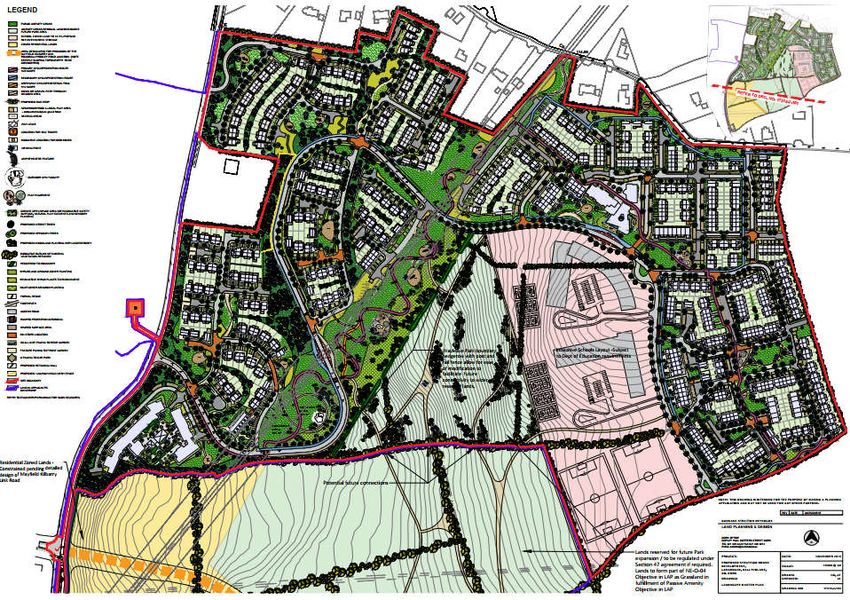
Table of Contents

               Executive Summary ....................................................................................................................... 3
1.0            Introduction .................................................................................................................................. 6
2.0            Planning Policy ............................................................................................................................ 15
4.0            Sequencing and Phasing .............................................................................................................. 32
4.1            Sequence of Development in Cork City ....................................................................................... 32
4.2            Phasing ........................................................................................................................................ 35
4.2.1          Preparation Phase ....................................................................................................................... 43
4.2.2          Phase 1 ........................................................................................................................................ 45
4.2.3          Phase 2 ........................................................................................................................................ 45
4.2.4          Phase 3 ........................................................................................................................................ 45
4.2.5          Phase 4 ........................................................................................................................................ 46
4.2.6          Phase 5 ........................................................................................................................................ 46
4.2.7          Phase 6 ........................................................................................................................................ 46
4.3            Timing .......................................................................................................................................... 46
5.0            Design Evolution & Density ......................................................................................................... 48
5.1            Density......................................................................................................................................... 48
5.2            Access Gradients ......................................................................................................................... 50
5.3            Economics & Viability .................................................................................................................. 50
5.3.1          Costs ............................................................................................................................................ 51
5.3.2          Sales Values ................................................................................................................................. 52
6.0            Conclusion ................................................................................................................................... 55
Appendix A     URDF Cork City and County Council Joint Application – Part 1 & 2 Application Form Extracts .. 56
Appendix B     Report of McCarthy McGrath Surveyors on Local House Prices and Mac Construction
               Consultants on Cost Abnormals .................................................................................................. 65
Appendix C     Extract from Linesight Average Irish Construction Costs 2018 ................................................... 74
Appendix D     Project Evolution ......................................................................................................................... 75
D.1            Density and Delivery ................................................................................................................... 75
D.2            Density and Housing Mix ............................................................................................................. 78
D.3            Density Evolution ........................................................................................................................ 79
D.4            Neighbourhood Layout Evolution ............................................................................................... 79
D.5            Ground Conditions (Roads and Cut & Fill Evolution)................................................................... 80
D.6            Design and Cut & Fill - Implications and Evolution...................................................................... 81
Appendix E     Pre Application TTA ..................................................................................................................... 93

All maps reproduced under OSI Licence Number: AR0097619

                                                                                                                                                                       2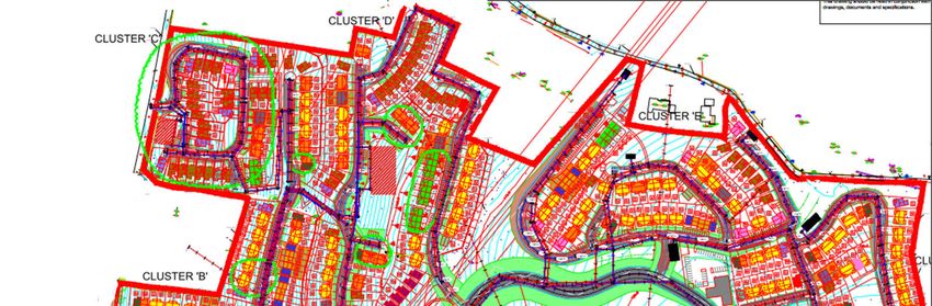
Executive Summary
This document describes to An Bord Pleanála (“ABP” or the “Board”) how the design of the proposal
to build 753 dwelling at Ballyvolane in Cork has evolved through twenty-months of preparation, and
gives a clear, reasoned argument for the design and engineering choices that we have subsequently
made.

It seeks to set out, not only the basis and logic behind our design choices, but also the facts that both
commercial and design constraints are an intrinsic part of the delivery process. The proposal is located
on challenging topography/sub-surface conditions and is adjacent to depressed housing and has
required considerable work and investment to forge into a scheme that can be successfully built.

Cork City is located on challenging topography with a stark choice of flood-risk-areas in the City centre
or hilly topography in the surrounding residual zoned areas. Ground conditions are also variable, with
many areas either underpinned by limestone to the south of the City or on old red sandstone and
mud-stones to the north.

As a result, most of the development in Cork City has occurred on the south-side of the City. This is
easier land to develop, access and service, but it is over five kilometres from the City Centre and is,
generally, served by local shopping centres taking focus away from the City. Very little new housing
has been built on the Northside, despite it being closer to the City (2-3 km), as access and services
have been difficult and expensive to provide. This is due mainly to complex topography causing higher
development costs which are not compensated by sales values which are, generally, lower than
elsewhere in the City. The Applicant has spent significant time and money ensuring that these services
can be provided These services not only cater for the Site, but also open up the wider residentially
zoned Ballyvolane Urban Expansion Area land to further development.

The Ballyvolane area (“Ballyvolane”) can be defined as an “Outer Suburban/Greenfield’ site”1. In fact,
as an Urban Expansion Area, Ballyvolane is the only remaining undeveloped land that is both zoned
and contiguous to the City of Cork. As part of this submission, enhanced connecting roads and
infrastructure are proposed to link the Site with the City area to the south. Critically, a PWSA (Project
Works Service Agreement) has been entered into with Irish Water whereby the Applicant is funding a
significant portion of network improvements by Irish Water to both service the Site and to unlock
other lands in the area; using a solution that has, prior to now, not been possible. The Applicant is
reserving substantial land for both road improvements and to provide a new Irish Water pumping-
station, having acquired further lands to the south to open-up the development and make this
possible.

The Lahardane site is unique in that, despite constraints, it is one large land-holding abutting the City
which is both capable of development and has a plan to provide the necessary services.

The soil and sub-soil conditions, challenging topography, Part L (the need to plan, cost and design for
NZEB Rated Houses), Part M (road gradient obligations), and the commercial realities that
house/residential values in Ballyvolane are lower than elsewhere in the City, create a housing-delivery
challenge that is not solved by simply adding more houses or units to the proposed mix. The Applicant
has carefully considered the mix, type and form of housing needed to open-up not just the Site, but
the wider Ballyvolane area to appropriate future development.

In summary, the current design, and its evolution has incorporated:

       1.   Planning Policy.

1
    Sustainable Residential Density Guidelines

                                                                                                            3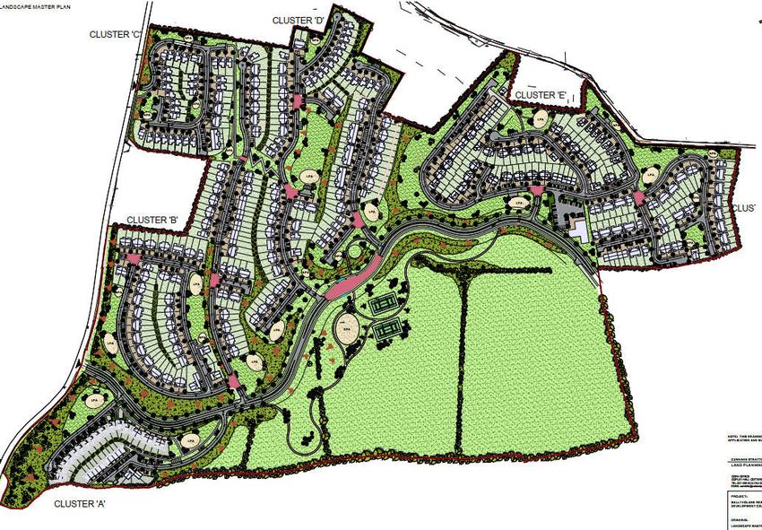
2. Topography / Ground Conditions.
3. Design Evolution.
4. Density (feedback and learning).
5. Commercial viability local market conditions – the same values are not generated in Cork,
Limerick or Galway as in Dublin for example.
6. On-site and off-site constraints.
To this end, the applicant is now proposing a development that, in broad terms:
Has a range of densities reflecting the variable differing topographies of the site;
Achieves 35.7 units P/Ha Nett despite rising topography, ground conditions and, currently,
low viability for residential apartments. Moreover, the proposal retains lands to “Plan and
Provide for the construction of 2.2 km Link Road from Mayfield to Kilbarry 2”;
Is phased to create a commercially and socially viable mix of uses;
Allows for connectivity and access to existing neighbourhoods & community;
Creates new and additional public transport;
Reflects the fact that the proposal must provide a distributor road through the site from
Ballyhooly Road (R614) to the north-eastern portion of the site.
We ask that the Board has regard to the fact that Cork City is not a single homogenous market for
house values and Ballyvolane, and the Northside in general, is a location in which house values are
lower as existing housing is sub-standard and the area lacks infrastructure. We ask that this also
considers the fact that build-costs in the Site are higher due to the complex challenging topography
and underlying ground conditions. Further, the Site is an initial “keystone” development which will
encourage further investment in a manner that is consistent with the LAP and is intended to lift the
image of the ‘Northside’ improving perception and attracting other developers as the development of
this Site will open up the lands to east.
In summary, the Site is less appealing economically than sites further from the City because:
1. Sales values in the Northside are, currently, depressed;
2. There are considerable additional costs in delivering 35 Units P/Ha Nett on a site which is a
hilly as this one. Our construction managers have advised this has a cost premium of between
€12 – 20k + in abnormal cost per unit.
3. Additional abnormal direct costs per unit are incurred due to foul water infrastructure and
surface water costs in the region of €3500 & €1500 per unit respectively.
4. Major 110kV electrical corridors/wayleaves traverse the Site and other zoned, undeveloped
lands on the north side of the City.
5. Notable road corridors exist in the north side of the City (i.e. the Mayfield Kilbarry Link Road)
that must be left untouched depending on detailed design.
6. Apartment complexes are less commercially viable in Cork as build cost is currently marginally
higher than the sales value and exceeds that of “conventional” housing 3.
2
Table 3.4.3, Cork County Council Cobh MD LAP
3
https://www.linesight.com/knowledge/2018/ireland/linesight-average-irish-construction-costs-2018 (see
Appendix Three)
4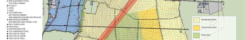
7.   Additional road infrastructure needs to be provided to open the area up to public transport
     and the City.

                                                                                                   5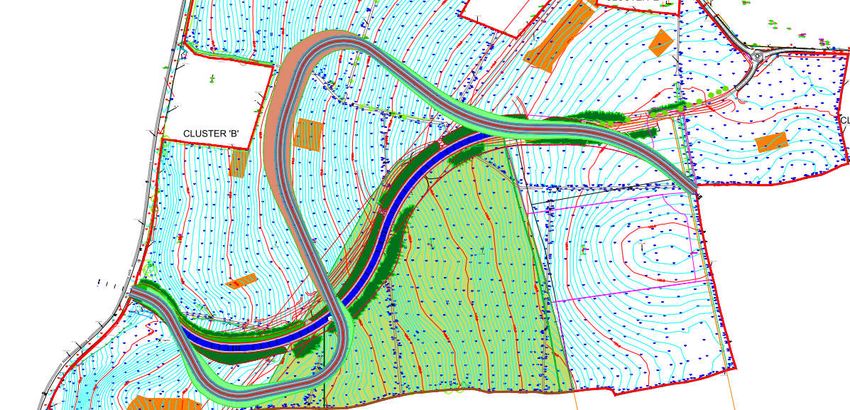
1.0 Introduction
This report will try to set out the evolution of planning proposals for a site at Ballyvolane (the “Site”
or “Lahardane” with the wider area referred to as “Ballyvolane”) by Longview Estates Ltd (also the
“Applicant” or the “Developer”). This process has taken twenty-months thus far and has involved one
prior consultation with the Board under PL04.300557, numerous meetings with both Cork City and
Cork County Councils in addition to regular meetings with statutory authorities and organisations,
such as Irish Water.
The document should be read in conjunction with the separate response to the An Bord Pleanála
opinion on 304350-19.
In their opinion the Board asked that the applicant consider the following:
1. Timing and Phasing of Development
2. Site Topography
3. Water and Waste Water infrastructure
4. Surface water management and Flooding
5. Residential Density
6. Traffic and Transportation
7. Public Open Space
8. Design, Layout and Unit Mix
These above issues are addressed in detail in the accompanying response to the ABP Opinion.
This document seeks to set out the evolution of planning proposals for the landholding. We, as a
design team have sought to minimise what we saw as adverse impacts, promote the positives and
take advantage of site features / constraints where possible.
The applicant has, over a period of years, extended their landholding. The current application
encompasses a larger landholding than was previously available to the applicant and that was
previously presented to the Board, under PL04.300557.
The acquisition of additional lands has allowed the applicant to address key concerns that the Board
noted during that pre-application consultation and;
allow for the set-aside of areas for roads
allow for the main Irish Water pumping station for the area (located on Ballyhooly Road) and
to;
increase the size and scope of the application.
In addition, by engaging with Irish Water, the provision of substantial funding for a Project Works
Services Agreement and the provision of land for a pumping station (located on Ballyhooly Road), Irish
Water has committed to carrying out network improvements under a Major Connection Agreement4.
This will address any foul water infrastructure needs that existed in the area for Phase One
development, as defined under the Local Area Plan provisions for the Ballyvolane Urban Expansion
Area (0-1175 Houses). The infrastructure will also allow for the wider Ballyvolane greater area to be
4
The upgrades that Irish Water will introduce will serve the site and other areas of new and existing
development in due course.
6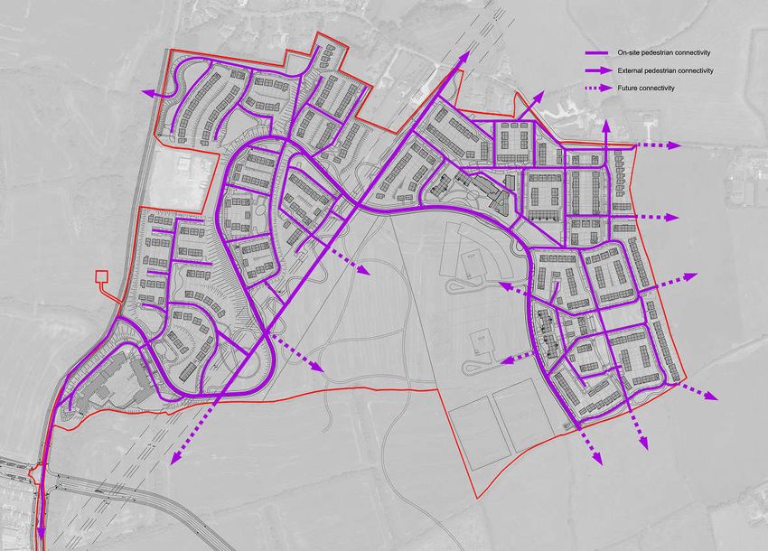
opened up and serviced. This will provide a significant block of land which can be developed for
housing whilst also providing for and respecting, the constraints identified by the Council in the LAP.
The applicant landholding, next to the Ballyhooly Road and encompassing the route of the Mayfield
Kilbarry Link Road, is important to develop in that it:

         1.     Delivers much needed, high quality, housing in the Northside of the City, on existing and
                proposed bus routes;

         2.     Develops the initial tranche of housing - 753 dwellings;

         3.     Reserves lands for the City Council to develop detailed designs of the Mayfield – Kilbarry
                Link Road.

         4.     Provides for physical pedestrian and cyclist linkage to the City and reserves lands for an
                agreed corridor for the upgrades to the Ballyhooly Road.

         5.     Solves a drainage problem for the entire area that had, previously, been insolvable.

1.1           The Proposal

The proposal is for the construction of a residential development of 753 dwelling units in the north
environs of Cork at Lahardane, Ballyvolane. The development includes open space and play areas,
internal roads, bus stops, Irish Water Foul and Storm Water Services and landscaping.

From a history viewpoint, the Board will note that there was another proposal by the applicant on a
portion of the lands now owned; PL04.300557. This proposed 457 units at a lower density with a
smaller landholding5; changes to density and landholding are critical issues to which we shall return.

The proposal is essential to the area being opened up to meet housing needs and to deliver on the
Local Area Plan zoning objectives.
The entire western side of the UEA requires delivery of new Foul Services in the form of a Foul Pumping
Station, to be served by local mains and downstream rising mains to Tivoli to the east. These upgrades
that Irish Water will introduce will serve the site and other areas of new and existing development in
due course. At present, the service capacity of the UEA and the entire northern area of the City,
without additional foul infrastructure, is very limited as both funding and delivery of this infrastructure
requires a significant number of housing units to be consented to allow it to take place.
This proposal, is core to Irish Water investment in the area as the infrastructure is privately funded via
a Project Works Service Agreement with Irish Water. A project of scale has to be allowed so as to
financially underpin a services solution. The services solution proposed enables wider development
potential to be unlocked and this infrastructure will allow Irish Water to enhance services to existing
estates, provide for new connections and allow for ongoing foul network management.
The foul pumping station solution, incorporated into our proposal adjacent to Ballyhooley Road is at
a location selected by Irish Water, to their design and specification. This will be taken in charge by
them and has the capacity to provide foul pumping services for 5000 + units in the future, depending
on network management, extensions and planning consents. Irish Water is committing to investment

5
    Additional lands were acquired to improve linkages and connectivity

                                                                                                              7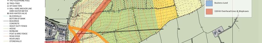
in the area because there is a viable volume of units in the pipeline being established by the
application.
Longview Estates Ltd is of the opinion that this evolution of design, in liaison with the state bodies,
has led to the formulation of a superior development that is better integrated into the landscape and
future transport networks, while also achieving greater and more sustainable density targets and
supporting a diverse housing mix.
Based on the previous consultation with the Board under PL04.300557, and further changes in design
and open space and connectivity in response to the Board’s opinion on 304350-19, the revised design
promotes higher densities, and comprehensive solutions to the challenges in the area.
1.2 Changes from PL04.300557 – the Initial 2017 Proposal
The proposal now before the Board is neither the same landholding nor scheme as presented to ABP
in 2017.
Fundamental changes have occurred in site size / land ownership (see Footnote 4, Section 1.1), access,
density, linkage and services solutions. These changes allow a proposal to evolve that creates a
cornerstone scheme that will open up access and services to the area in a phased manner, commences
private sector investment in services and housing, and correlates with Council actions in the delivery
of infrastructure.
In summary, the core changes relate to the applicant’s acquisition of additional land to the south and
west of the initial landholding (under PL04.300557). This is important as it allows for;
Direct linkage to existing built up areas in Cork City suburbs, siting of roads necessary to the
development and the siting of a new pumping station to allow foul water to be dealt with.
The provision of a critical Pumping Station on Ballyhooly Road for Irish Water to serve the later
phases of the scheme and provide services for other proposals in the UEA. Opening up the
application lands and the potential for 3000 - 5000 units to be serviced in the UEA.
The applicant to reserve lands for the entire 20 Ha Public Park if and when required by Cork
City Council.
Reservation of lands for the future provision of the Mayfield Kilbarry Link Road – part of the
Inner Northern Distributor Road in CMATS (Cork Metropolitan Area Transport Strategy).
The creation of the only access identified in the Cobh MD LAP to deliver Distributor roads from
the Ballyhooly Road eastwards into the Urban Expansion Area. The proposal constructs
distributor roads NE-U-03 and NE-U-04 which open up the western side of the Urban
Expansion Area. These provide access from the east to within the landholding and beyond,
access lands that are to be set aside for the Department of Education for schools to serve the
entire area Urban Expansion Area and open up the park area to future use. None of the lands
to the south of the application site that are also located abutting the Ballyhooly Road are
required to be developed so as to serve areas to the north.
8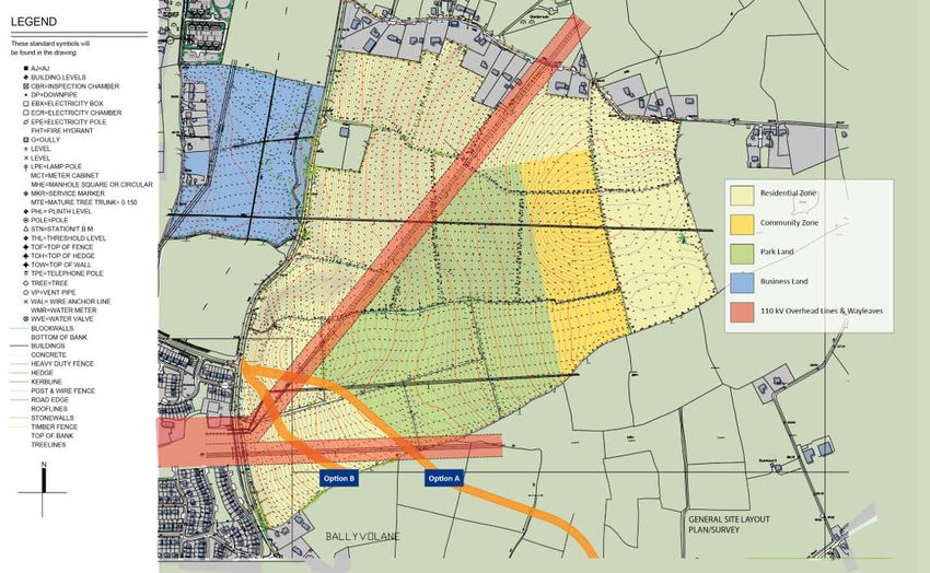
Provide for the widening of the Ballyhooly Road for the implementation of the BALLYVOLANE
STRATEGIC TRANSPORT CORRIDOR PROJECT: NORTH RING ROAD TO BALLINCOLLY, JUNE
2019”6
Signalise junction between the Ballyhooly Road and Lower Dublin Hill.
Image 1, following, shows the lands in ownership for 2017. Image 2, following, shows the lands in
ownership in 2018 (this design).
6
Pages 1-2 included as Appendix B
9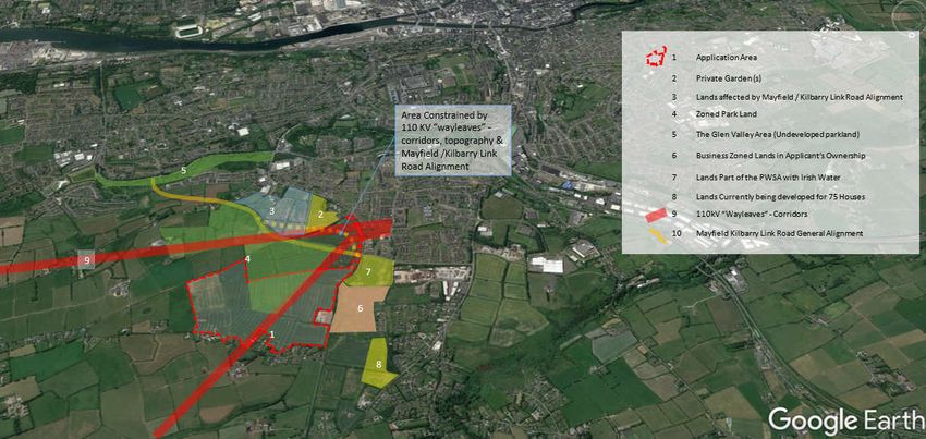
Image 1:   2017 Land Holding

                               10
Image 2: 2018 Landholding – Red Line Application Area and Blue Line Ownership
Yellow = Original Application Site and Land Holding
11We wish to give the Board a clear understanding of the choices and challenges faced in developing
this site to a “Residential Guidelines Density” compliant standard where there are hills,
design/engineering constraints and commercial delivery issues with respect to the sale value of
properties in Ballyvolane relative to other more lucrative and established parts of Cork City and other
areas around the City.
We also believe that a high-quality development at Lahardane, and the establishment of the
infrastructure to support it will both enhance the character of the ‘Northside’ and will open-up other
lands for development in the wider Ballyvolane area.
This report will set the overall development of the site in the context of the local and regional planning
framework and will address the evolution of the detailed scheme design. To this end the report will
consider:
Planning Policy
Topography / Ground Conditions
Design Evolution
Density (feedback and learnings)
Economic Viability
On-site and off-site constraints
Some of the above issues are referred to and addressed in the response to the Board’s Opinion on the
Pre Application Discussion.
1.3 Changes from the Pre Application Consultation to the Full Application Submission
The Board has offered an opinion following the Pre Application Consultation ABP-304350-19.
Certain design changes, that create further design evolutions, have been made on foot of this which
include:
The creation of an additional enhanced separated pedestrian and cyclist route in
Neighbourhood 5 (east of the school zone and the distributor road). This has necessitated
changes to unit mix and layout and the need for alterations to drainage (surface water) / open
space areas. It also creates the opportunity for a completely separate, cyclist and pedestrian
route through the housing areas from the southern boundary of Neighbourhood 5 through
Neighbourhood 2 and onto the “Greenway” park / 110 kv wayleave route heading to
Neighbourhood 1 and 6.
The introduction of a vehicle linkage to the local road to the north. This has necessitated
changes to unit mix and layout and the need for alterations to drainage (surface water) / open
space areas. This vehicular access has been designed (from a connectivity viewpoint) to be
available to trip movements but not to be designed as a priority connection.
The creation of additional housing frontages onto the Distributor Road.
The creation of additional housing units in Neighbourhood 1 and Neighbourhood 3 facing on
to the Greenway and Open Space to create additional overlooking.
12 The introduction of houses in specific locations to ensure passive overlooking of open spaces
and linkages.
The loss of housing units has occurred in certain areas due to design changes and but the
overall numbers proposed (50+ per Ha Nett close within 500 m of the Ballyhooly Rd Bus Stop
207 / 207A) and 35.7 Per Ha Nett overall remains). In locations, duplex units have been
removed and terraced / semi detached units introduced so as to increase numbers lost
following redesign, post tri partite meeting, to increase open space and connectivity provision.
Extension of roads to boundaries with third party properties in three locations to the west of
the site; the applicant reiterates that we are not creating “ransom strips” to services and roads
and we are allowing for connections to adjoining lands.
Increasing the size of the Creche following advice from the Cork Childcare Committee.
The introduction of additional open spaces in Neighbourhood 5 following discussions with
Cork City Council.
The introduction of gable fronted properties / passive overlooking in areas where linkages
through to third party lands may occur in the future.
Moving the Type 3 Pumping Station in Neighbourhood 5 to the west of the distributor so as
to maintain residential density (not lose units) due to the pumping station set backs. This
created an additional cost and an additional 500 m3 of drainage excavation.
The introduction SUDS measures, additional to the attenuation and infiltration previously
proposed by the use of permeable paving in locations and the use of “swales” in green areas.
The provision of a bus turning area and bus stops internally within the scheme.
Image 3 following shows many of these changes.
13Image 3: Changes from the Tri Partite Meeting – Also see Architects Design Statement
142.0 Planning Policy
Lahardane & Ballyvolane Urban Expansion Area in context – why Lahardane?/why Ballyvolane?
Ballyvolane is a natural extension to the City
While Cork County Council has identified a need for 22,000 housing units 7 to cater for growth in and
around the City Environs, there is limited land being developed in the right places as natural extensions
to the City.
Local issues, land ownerships, policy challenges and market/commercial viability all challenge the
delivery of housing.
What does Ballyvolane, and more specifically the application Site, have to offer that addresses the
above housing need?
The Lahardane site is unique in that, despite constraints, it is one large land-holding abutting the City
which is both capable of development and has a plan to provide the necessary services.
The site will be serviced, accessible and developable at commercially viable densities. Additionally, it
opens-up access to significant adjacent lands to the east which will otherwise be land-locked from the
City. The large-scale of this development is such that it will provide sufficient core infrastructure,
sewers and distributor road access to the east and will encourage smaller developments that would,
otherwise, not be economic.
The scheme reserves areas that are needed for important roads and infrastructure and is contributing
significantly to the provision of such roads and services.
The Ballyvolane area is identified by the County Development Plan and Local Area Plan as an “Urban
Expansion Area” and is only 2-3 kms from the City Centre. The Urban Expansion Areas are one of the
central components of the growth of Cork City.
The area is identified as a location for growth, housing and investment in:
the Draft RSES.
The CMATS – The Cork Metropolitan Transport Strategy.
Cork Area Strategic Plan.
The County Development Plan.
The Cobh MD Local Area Plan.
The importance to the sub region in seeing this area opened up has also been emphasized by both
Cork City and County Council’s in that they have sought investment in roads infrastructure in the area
under the URDF (Urban and Regional Development Fund) and have obtained NTA funding for the
widening of the Ballyhooly Road for the implementation of the BALLYVOLANE STRATEGIC TRANSPORT
CORRIDOR PROJECT: NORTH RING ROAD TO BALLINCOLLY, JUNE 2019”8. This is the only bus corridor
7
Page 13 of Cobh MD LAP
8
Pages 1-2 included as Appendix B
15scheme at present accessing the UEA.
The Councils are not in control of Irish Water investment; that has been secured by this applicant and
this application through a Private Works Service Agreement / Major Connection Agreement
negotiated with Irish Water for delivery of Foul Water services that will serve the site. This
infrastructure will also serve existing / proposed areas of development subject to Irish Water
agreement.
In addition, the site is located close to an existing District Centre (Dunnes Stores, Ballyvolane), which
has recently been physically upgraded, a local Lidl store (located in the Town Centre zoned area of
Ballyvolane – NE-T-01) and the Kilbarry Employment Centre.
The Cobh MD LAP recognizes that Ballyvolane has an important role in development in the North City
area. It states that;
“In the overall strategy for the Local Area Plan, the Cork City North Environs consists of a
suburban area that adjoins the administrative area of Cork City within the metropolitan
area. In terms of future growth, The CASP Update 2008 seeks to prioritise those areas close
to the city and located along the suburban rail corridor. It is crucial that the approach to
accommodating the targeted population increase in the North Environs is cognisant of
CASP proposals and the need to create a critical mass to promote public transport options
and support a new district centre. The CASP Update specifically identifies Ballyvolane as
having the most potential for future population growth, in particular, private sector
housing development as it is located adjacent to the strategic
employment centre at Kilbarry. The retail strategy for Cork County, as set out in the Cork
County Development Plan 2014, has also identified Ballyvolane as a potential district
centre serving the north east of the city”9.
(emphasis added)
Cork City and County Councils have a long tradition of planning for the expansion and development of
the Greater Cork Area as part of the broader strategic, sub regional planning approach 10.
In implementing strategic sub-regional plans, such as the Cork Area Strategic Plan, the County Council
has identified Urban Expansion Areas to accommodate new housing demands and population growth.
The Lahardane site now before the Board, and the entire Ballyvolane area, is a key part of one of the
main UEA expansion areas.
Over recent plan cycles, the aim of developing the Ballyvolane Area has been identified. The Cobh
MD LAP sets out the history of development in Ballyvolane and the Council’s development strategy,
which involves advanced master-planning, land-owner agreements and the broader delivery of
services. This approach has been proposed and attempted in other urban expansion areas and has,
due to a number of reasons, not managed to encourage the development of the lands, leaving Cork
desperately short of housing.
9
Page 81, Cobh MD LAP
10
Cork Area Strategic Plan
162.1 Why Does This Site Deliver Policy Objectives Of The LAP In A Manner That No Other Site Can
This site is unique in that it:
Is the only land parcel suited to delivery of Phase 1 LAP objectives. The Longview Estates
landholding delivers Phase 1 LAP objectives in a way that no other site or landholding in the
UEA can.
It provides foul infrastructure solutions that no other site does.
It provides (and is required to provide) access roads to the western side of the UEA that no other
site does.
It provides Park Land opportunities (that open up parkland uses for other areas in the UEA) that
no other site does.
It “opens up” and services zoned primary and secondary school lands in the UEA that no other
site does.
In summary, we submit that this site brings forward Local Area Plan Objectives for Phase 1 of the UEA
in a manner that is “sequentially” correct having due regard to constraints of 110kv corridors and long
term roads reservations.
2.2 Reconciling Policy and Topography
The proposal seeks to deliver a design solution to a complex series of challenges, opportunities and
constraints. The northside of Cork City is not an easy location to develop and deliver housing with
current design guidance and building standards but this proposal does.
These areas have “challenges” of some form or another; whether land ownership, economics, services
or the topography. These challenges necessarily influence design and engineering choices and they
are reconciled in the current design and land holding assembled.
The Longview Estates landholding is well defined as a large c.220 acre landholding adjoining the
Ballyhooly Road / R616. It is a hilly, rising site that climbs to a “plateau” to the north east and central
areas of the UEA.
The northern portion of the holding presents challenging topography, but also has the only defined
access point and alignment for service roads to the north west of the UEA. In this respect,
development has to proceed from the western side of the Ballyhooly Road.
As a result of the topography, the proposal, in having to work with access gradients advocated by
DMURS and roads radaii defined by Roads Design Standards, sees the proposed Distributor Road
accessing the site traversing the topography in a circuitous route.
From an environmental viewpoint, this is much better than the route (NE-U-03) proposed by the LAP
as the “LAP Route” would see very significant volumes of cut as one excavated through significant
volumes of rising land. The alignment would also lead to challenges in connectivity and gradients for
pedestrians / cyclists.
It has also allowed the opportunity to create defined Neighbourhoods within the scheme where,
flatter, DMURS & Part M compliant neighbourhoods are created. In this manner, we are working with
the landscape, design, topographical and zoning parameters to create housing “neighbourhoods”,
appropriate (gradient 1:20) pedestrian linkages, amenity areas and integrate the 110 kv wayleaves
into parkland and connectivity solutions walkways.
17This above ground work is also matched and reflected in sub surface engineering and ground works.
Cut and Fill areas are created, and attenuation, infiltration and SUDS areas established in open space
areas.
The southern portion of the landholding (a portion that is outside the application area but within our
ownership) is constrained by topography, the “wayleaves”11 for two no. 110kv Power corridors and
the Mayfield Kilbarry Link Road Corridor (Image 3). Note, that image also shows two alignment
options for the Mayfield Kilbarry Link Road. Option A is the LAP identified route; this creates a large
cut through the hillside. Option B is a route that more naturally follows contours and has less of an
impact (less cut). These options would naturally be assessed as part of the detailed design of the
Mayfield Kilbarry Link Road but the choice options do highlight the constraint presented by the route
at this stage.
There is however, sufficient unencumbered land available to construct the required Irish Water
Pumping Station for the entire western and southern portion of the UEA along with the permanent
alignment of the cycle way and pedestrian footpath for the “Ballyvolane Strategic Transport Corridor
Project: North Ring Road To Ballincolly” (now in design for delivery in 2022).
However, pending the resolution of the detailed alignment of the Mayfield Kilbarry Link Road
(although the junction of the Ballyhooly Road / Lower Dublin Hill and the Mayfield Kilbarry Link Road
is well defined), and the location of the 110 KV wayleaves, this area is not readily developable for
residential uses. The confluence of the 110 kv wayleaves & Mayfield Kilbarry Link Road route, and the
topography means that the area where the 110 kv lines cross the Ballyhooly Road is very challenging
for building delivery in the short term.
2.3 Visibility, Intervening Zones and Topography
The site, in a broader context, is separated visually from the mass of the City to the south (around the
R635 junction with Ballyhooley Road), by topography and the NE-O-04 12, NE-T-01 13 and NE-C-02 14
Zones.
Part of the NE-O-04 zone will provide a 20 Ha Public Park. Our land holding contains approx. 20 Ha of
zoned NE-O-04 lands and we are proposing to enter into a Section 47 agreement with the City Council
on the reservation of lands for same. The southern boundary of this NE-O-04 area will ultimately be
defined by the route alignment of the Mayfield Kilbarry Link Road which will be delivered c. 2031.
This latter road forms part of a wider orbital route that will be delivered by linking proposals across
the north site of the City (under CMATS); it is a route that has the potential to fundamentally change
traffic flows in the City once completed but currently demands further design work which limits the
delivery of lands in the southern portion of the Urban Expansion Area as the detailed alignment and
relationship to lands is not yet known.
Connections into and through the wider area are also supported by the application. These
connections support pedestrian, cyclist and vehicular connection. A broader landscape strategy,
prepared by AECOM, and agreed by Cork City Council Parks Department as a template for the
Landscape Strategy across the UEA, is also incorporated into this proposal.
11
Under ESB Guidance, no buildings are allowed under 110 kv lines under a 50 m corridor but the lands can
function as locations for roads or generally open space locations / connections.
12
a 35.4 Ha Open Space Passive Amenity area
13
The Lidl and Town Centre areas by Fox and Hounds
14
A Primary School Site that is landlocked
18Image 3: Constraints (including Mayfield – Kilbarry Link Road – Option A [LAP Route] ; Option B
[less “excavation / cut” route as it follows contours]
19Drainage and services solutions are incorporated into the application (the proposed Irish Water
Pumping Station on Ballyhooly Rd that provides for capacity to service the Urban Expansion Area) and
the scheme is designed so as to deliver solutions that support Irish Water’s objectives for the area and
beyond. These are addressed in the EIAR and NIS provided as part of the application; the EIAR setting
out significant impacts and mitigation measures for the environment.
In summary and conclusion, the proposal seeks to deliver a design solution to a complex series of
challenges, opportunities and constraints. There is no ideal design solution when developing on hilly
topography as each site, with intrinsic design constraints, policy demands, sub surface challenges and
wider interactions with adjacent lands offers a different set of responses.
2.4 Delivery of Housing to meet Policy Needs
Image 4 (following), illustrates the location of the current Urban Expansion Areas. Image 5 (following)
illustrates the location relative to the City and Image 6 illustrates the wider zoning that applies to the
area and local constraints over development. In these areas, very limited housing development is
occurring.
Table 1 identifies the various Urban Expansion Areas identified by Cork County Council in the County
Development Plan, all of which have either had specific objectives expressed in the Local Area Plan or
SDZ Approvals by An Bord Pleanála. However, only limited housing activity is taking place.
Table 1: UEA – Current Status
Shannonpark in Carrigaline Limited Housing Activity
Water-Rock in Midelton LIHAF Site. No Activity other than Part 8 and
landowner discussions with Council as to how
integrated planning solution can be delivered.
Part 8 approved by Cork County Council but no
landowner engagement.
Carrigtwohill North in Carrigtwohill Limited funding under URDF for part of Phase 1
Access Road. No housing activity.
Ballincollig South (Maglin) in Ballincollig No Activity.
Ballyvolane in North City Environs Proposal under this Fast Track Application
Process of 74 units permitted on Old Dublin Pike.
Irish Water services solution via an agreed PWSA
allowing for infrastructure upgrades in the area
with contracts signed for same that Irish Water
will implement. This development supports the
majority of costs associated with the PWSA.
Ballinglanna – Dunkettle in Glanmire Fast Track Consent issued. Density less than 35
Per Ha. Site works under way; understood that
compliance with conditions is being sought.
Stoneview in Blarney No Activity.
Monard SDZ No Activity.
Cobh North in Cobh No Activity/refusals if consent for Fast Track
Application in Ballyleary.
20In summary, whilst Cork County Council has identified a need for 22,000 units15 to cater for growth,
very limited amounts of land are being developed. Ballyvolane will deliver 753 units and open-up an
area that has, to date, been sterilised through lack of infrastructure. It will also enhance the perceived
image of the ‘Northside’, investing in the area, promoting new-build residential for the first time in a
generation and supporting reinvestment in the existing social and community infrastructure.
The importance of the ‘Northside’ in the growth of Cork has been recognised, not only by the County
Council in policy documents, but by representative bodies such as the Chamber of Commerce. Cork
Chamber CEO, Conor Healy, has, in a recent Cork Chamber of Commerce publication16, discussed the
opportunities for the Northside of Cork City in light of Project Ireland 2040, in which he highlighted
the need for much improved and diversified transport infrastructure, the employment potential and
the overall latent opportunities for the City.
Despite the need in Cork for the development of housing, this is not currently happening.
15
Page 13 of Cobh MD LAP
16
Chamberlink, Q4 2018
21IMAGE 4: UEA locations identified by Cork County Council
22IMAGE 2: Site Location / Selected Zoning
23IMAGE 6: Constraints - Detailed Topography, 110KV Infrastructure the potential alignment of the Mayfield – Kilbarry Link Road (Lands covered by Topographical Survey are in Client Ownership) – ZONING OVERLAY
243.0 Topography & Ground Conditions
Topography and Ground Conditions
Cork City is situated such that most residential development has a stark choice between severe flood
risk or hilly topography. This means that sequentially, not all development can or should occur in what
may seem an obvious sequence on a map.
Zoned lands to the north of the City are predominantly in areas where the local steeply rising
topography makes viable high-density development difficult and design compromise necessary.
Workable road gradients are also difficult to achieve. Achieving 30 – 35 per Ha Nett in such
circumstances is very challenging.
In addition, the area houses significant infrastructure that challenges what can be developed
irrespective of zoning. For example, 110 kV wayleave corridors10 cannot provide housing and
significant volumes of zoned lands can be lost to embankments and cuts to create workable access
roads. Sub-surface ground conditions also create further constraints when making the Site work.
In summary, we ask the Board to note that the selection of the northern portion of the site to develop
initially has been based on real constraints and challenges to the southern portion. These include
where 110 kV infrastructure and road reservations (detailed design pending) justify developing to the
north of these constraints in particular given the linkages created to the south, the pedestrian
connectivity, the cyclist connectivity and the new infrastructure including foul water service.
Image 7 (following) shows the layout proposed under PL04.300557. This initial design solution
resulted in a layout with a lower density than desired by the Board or National Policy under
PL04.300557. This previously proposed density of 18 P/Ha Nett (under PL04.300557) was in
accordance with the Council LAP Objectives.
It shows the previous road alignment, which followed the Council LAP alignment at DMRB Gradients
which were considered undesirable by the Board. This alignment necessitated an extensive cut into
the landscape and the only way to reduce this was to change to the new alignment. The Ballyvolane
area is identified by Cork County Council as an “Urban Expansion Area”. It is a challenging area to
develop. The area has topographical and infrastructure constraints17 to factor into development
proposals while also having to maintain consistency with the overall zoning strategy and objectives of
the County Council MD LAP. ABP under PL04.300557, expressed concerns as to density (and other
matters) and the applicant team was faced with the challenges of:
1. Increasing the density to meet ABP concerns.
2. Dealing with a Distributor Road that traverses the land holding from South West to North East
(Cobh MD LAP NE-U-02).
3. Providing for Council demands that a lower road gradient be achieved.
4. Connectivity within the site and to existing urban development.
5. The site remaining hilly; rising up from the Ballyhooly Road to the flatter lands above; and
6. The potential of “Leapfrogging”, the sequential development of lands outwards from the City.
17
110 Kv Corridors / Roads Objectives and Reservations / Topography
25IMAGE 7: ABP PL04.300557 Layout Initial Longview Design 2017
26Each of these points is dealt with below in Section 3.1 however, the it should also be read in
conjunction with the separate response (cover letter) to the An Bord Pleanála opinion on 304350-19
which offers detailed commentaries on ABP’s opinion where we were asked to consider the following:
Timing and Phasing of Development
Site Topography
Water and Waste Water infrastructure
Surface water management and Flooding
Residential Density
Traffic and Transportation
Public Open Space
Design, Layout and Unit Mix
3.1 Responding to Design / Delivery Challenges
1. Increasing Density
Following the ABP determination previously issued, the applicant has acquired additional lands in
Lahardane. This has afforded us the opportunity to review the project design to achieve a density of
at least 30 – 35 Per Ha Nett viably in areas that are not constrained by roads, zoning objectives or
wayleaves to the south. The consequence is that we have achieved a density of 35.7 Per Ha Nett and
this will be considered in more detail in Section 5.0 of this report (this increased from 35.3 Per Ha Nett
as proposed under the Pre Application submission to ABP). The new alignment, with added
connectivity to the Ballyhooly Road, Irish Water Pumping Station to allow for future servicing of the
site. The UEA is shown in in Image 5.
2., 3. & 5. Distributor Road Alignment, Gradient & Topography
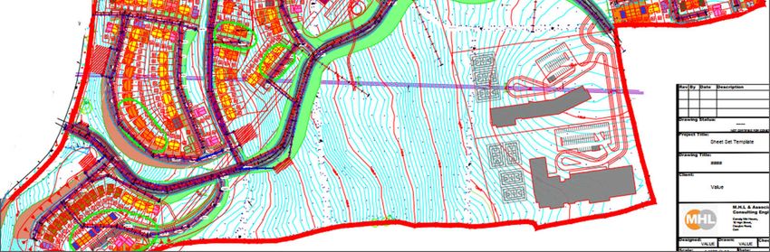
Image 8 following shows detailed topography of the Site. This topographical survey is far more
detailed than any OS Survey Map and clearly shows the challenging gradients to the west of the site.
This site has to bear the cost and challenges of providing the access to, not only the applicant’s lands,
but also to the zoned lands to the eastern end of the access road, that are outside of our ownership
and currently landlocked, allowing for higher densities to be achieved in those lands without the
attendant cost/design challenge of getting up into the site.
Intrinsic to the question of density and the delivery of a sustainable scheme is the matter of access.
Cork County Council, under the Cobh MD LAP, have an objective for a Service Road under NE-U-03
and other links (NE-U-02 and NE-U-04) which open up the west of the Urban Expansion Area. This site
is the only landholding that provides this link.
In order to provide this road with a satisfactory gradient, and without excessive cut-and-fill, a
circuitous route has had to be followed at a point from the southern portion of the site. This diverges
from the LAP alignment; Cork County Council agreeing pre application that this is a better design. This
access road then informs the layout of housing areas and the parcels of land that can be utilised while
applying DMURS gradients (Image 9 following). While all the site is zoned the topography and access
gradients demanded has meant that many areas of the site, zoned for residential use, cannot
physically accommodate it due to gradients and embankments.
27The commercial challenges of developing housing in these areas in Cork are considered in more fully
in Section 5.
The redesigned access solution and Distributor Road alignment has allowed the proposal to create a
more appropriate solution for pedestrians by allowing lower gradients. The access and design solution
has also allowed the integration of the 110 kV wayleave corridors into the landscaping of the site and
the creation of greenways though the site from the north-east down to the south-western corner of
the site.
4. Connectivity
As described above, the new road alignment has allowed the proposal to create a more appropriate
solution for pedestrians with lower gradients within the site. The integration of the 110 kV wayleave
corridor has been used to create a greenway enhancing connectivity further.
Plate 1: Connectivity
The additional lands purchased to the south have been used to create pedestrian and cycle linkages
to the previous proposal. Additionally, the applicant has reserved land for the development of the
Mayfield Kilbarry Link Road. We are committing to the City Council that they will remain free from
development so as to afford the City Hall the maximum flexibility on their detailed design process.
28IMAGE 6: Detailed Topography, 110KV Infrastructure the potential alignment of the Mayfield – Kilbarry Relief Road (Lands covered by Topographical Survey are in Client Ownership) – ZONING OVERLAY
29IMAGE 7: Proposed road access solution internally without the site with a color coded plan showing road gradients, cut and fill
30The Mayfield Kilbarry Link Road is programmed for delivery by 2031. The proposal is contained in
CMATS and the Cork City Council recently applied for funding for the Mayfield Link Road under the
URDF fund but was unsuccessful.
The Joint City / County submission for the URDF Funding is attached as Appendix A. That submission
clearly shows;
a) The ease of public transport services in the area;
b) Support for densities at over 30 P/Ha Nett (reflecting the topography)18;
c) The importance of new housing in the area in a location proximate to employment hubs in
Kilbarry;
d) The fact that the Kilbarry Mayfield Link Road is also identified in the Draft CMATS (Cork
Metropolitan Area Transport Strategy – See Appendix A).
The road is identified in the Cobh MD LAP as something that the Council must “plan and provide for”.
This is achieved by us as our lands area being reserved by the applicant free from development to
allow flexibility in any design/alignment choice as it progresses east from the junction of Ballyhooly
Road and Lower Dublin Hill.
Table 3.3.4 of the Cobh MD LAP states that Phase 119 of the MD LAP is to “Plan and provide for the
construction of 2.2km Link Road from Mayfield to Kilbarry”. Phase 2 of delivery of units in the
Ballyvolane UEA (Units 1175 – 2325) states that the Council will “continue completion” of the road.
The approach of the applicant is therefore consistent with the Plan’s “indicative” objectives.
The Board will also note that the traffic modelling submitted with this application does not depend on
the Mayfield Kilbarry Link Road being delivered.
6. Leapfrogging
At the 2017 (PL04.300557) consultation with the Board, we were advised that there were some
potential concerns that developments need to follow a sequence and not “leap-frog”. In section 4 we
discuss leap-frogging in relation to:
a) the context of the Ballyvolane Urban Expansion Area in relation further development in Cork
City and its surrounds, and
b) the Longview development (this application) in relation to the sequential development within
the Ballyvolane Urban Expansion Area.
This matter is addressed in detail in Section 1 of our letter of response to ABP’s opinion.
Images 1 and 2 of this “evolution” document already illustrate the manner in which the land holding
has increased in size so as to provide for an improve, deliverable, design solution to complex design,
servicing and linkage challenges evident in the area.
18
The proposal is now at 35 p/Ha +
19
Units 0 - 1174
314.0 Sequencing and Phasing
Firstly, this section addresses the development of the Ballyvolane Urban Expansion Area in relation to
existing built up areas and the consistency to the NPF’s aim of “compact urban growth”. It continues
to outline the natural sequencing of the Longview development in relation to the Ballyvolane Urban
Expansion Area, more specifically.
Secondly, a logical sequential internal phasing for the development is proposed. The project has been
conceived to allow the first housing area to be located closest to the southern part of the site. This
allows placemaking to occur establishing the address as a residential location. Site access/distributor
roads will be developed at the beginning of the build, allowing the creation of a core spine of the site
and the establishment of the local center in Neighborhood 2. The subsequent phases will allow for
progressive infilling of the remaining areas.
4.1 Sequence of Development in Cork City
This matter is addressed in detail in Section 1 of our letter of response to ABP’s opinion.
Images 1 and 2 of this “evolution” document already illustrate the manner in which the land holding
has increased in size so as to provide for an improved, deliverable, design solution to the complex site,
servicing and linkage challenges evident in the locality.
At the 2017 consultation with the Board, we were advised that developments need to follow a
sequence and not “leap-frog” from the City outwards. Section 3 outlines the wider constraints of
topography, infrastructure and zoning (and the parks and access requirements of the Phase 1 delivery
of land sin Ballyvolane UEA), in explaining why development is proposed towards the northern portion
of the applicant’s landholding; i.e. mainly due to the constraints created by the Mayfield Kilbarry Link
Road and the 110 KV corridors.
While there are frequent policy requests for more compact urban growth, development is already
evident at further distances from Cork City Centre. Image 10 shows:
1. The proximity of the site to the City;
2. The location of major development locations that are considered to be part of the broader City
area; clear evidence that the City Suburbs and other zoned development lands are located further
from the City Centre than the Ballyvolane Urban Expansion Area. The Ballyvolane Urban
Expansion Area therefore addresses the NPF aim of “compact urban growth”;
3. Presence of developed/consented areas to the west and north west of the site/land holding.
Furthermore, the development of the Site is consistent with set development principles of the
Ballyvolane Urban Expansion Area, as the land;
a) is the logical first development in the Urban Expansion Area off the Ballyhooly Road due to
infrastructure and topography constraints to the south (this is discussed fully above in Section 3).
b) provides for connectivity to the City.
32c) meets CMATS objectives.
d) is located closer to the City than other potential housing developments in the southern suburbs.
e) is located closer to the City than other development sites to the north-west of the Ballyhooly
Road which have been recently consented.
f) is unlike other land holdings that are small and at best can only deliver piecemeal development
and do not deliver the range of Phase 1 objective such as parks and connectivity.
g) This proposal offers the scale and scope required to carry the additional costs (Irish Water
services) to unlock the wider area.
h) there is a natural barrier (Glen Valley) on the southern side of the Urban Expansion Area which
physically separates northside from the existing city development. All development will radiate
north from the Fox and Hounds, Image 3. Lands between the “Fox and Hounds” and the applicant
landholding are smaller, fragmented, possess infrastructural uncertainties in relation to
Mayfield/Kilbarry Link road alignment and do not deliver the range of Phase 1 objective such as
parks and connectivity.
The existence of this development will not only meet housing objectives and needs, but will also
encourage, justify and facilitate the creation of additional transportation infrastructure and create
modal shift options for future development.
In addition, the provision of essential foul and services infrastructure, funded by the applicant, will
open-up the lands to the east of the site which would otherwise remain landlocked.
33You can also read