PROPOSED MIXED USE DEVELOPMENT - LOT 1 (242) WEST COAST HIGHWAY, SCARBOROUGH - DECEMBER 2020 - DevelopmentWA
←
→
Page content transcription
If your browser does not render page correctly, please read the page content below
PROPOSED MIXED
USE DEVELOPMENT
LOT 1 (242) WEST COAST
HIGHWAY, SCARBOROUGH

DECEMBER 2020
URBIS STAFF RESPONSIBLE FOR THIS REPORT WERE:
 Director                  Kris Nolan
 Associate Director        Megan Gammon
 Project Code              P0004793
 Report Number             Updated – 27 January 2021

All information supplied to Urbis in order to conduct this research has been treated in the strictest confidence.
It shall only be used in this context and shall not be made available to third parties without client authorisation.
Confidential information has been stored securely and data provided by respondents, as well as their identity, has been treated in the
strictest confidence and all assurance given to respondents have been and shall be fulfilled.

© Urbis Pty Ltd
50 105 256 228

All Rights Reserved. No material may be reproduced without prior permission.

You must read the important disclaimer appearing within the body of this report.

urbis.com.au
CONTENTS
1.          Introduction .......................................................................................................................................1
            1.1.     Summary of proposal ...........................................................................................................1
            1.2.     Planning Approval ................................................................................................................2

2.          The Site and Locality ........................................................................................................................3
            2.1.     Regional Context .................................................................................................................3
            2.2.     Local Context .......................................................................................................................3
            2.3.     The Site ................................................................................................................................5
            2.4.     Existing Access ....................................................................................................................6
            2.5.     Servicing ..............................................................................................................................6

3.          Process and Engagement to Date ...................................................................................................7
            3.1.    Agency Engagement............................................................................................................7
            3.2.    Community Engagement .....................................................................................................7
            3.3.    Design Evolution through Design Review ...........................................................................9

4.          The Proposal ....................................................................................................................................11
            4.1.    Architectural Statement......................................................................................................11
            4.2.    Development Summary .....................................................................................................12
            4.3.    Landscape Strategy ...........................................................................................................13
                    4.3.1.       Deep Soil and Planting on Structure ..................................................................15
            4.4.    Pedestrian Access Way .....................................................................................................15
            4.5.    Traffic, Parking and Access ...............................................................................................16
                    4.5.1.       Vehicle Access ...................................................................................................16
                    4.5.2.       Car, Bicycle Parking and End-of-Trip Facilities ..................................................17
                    4.5.3.       Waste and Service Vehicle Access ....................................................................17
                    4.5.4.       Traffic Analysis ...................................................................................................17

5.          Design Excellence and Community Benefit .................................................................................18
            5.1.    Height Analysis and Transfer .............................................................................................18
            5.2.    Bonus Height Provisions ....................................................................................................20
            5.3.    Design Excellence .............................................................................................................20
            5.4.    Community Benefits ...........................................................................................................22
            5.5.    Response to Community Feedback...................................................................................23

6.          Specialist Technical Inputs ............................................................................................................24
            6.1.     Transport Impact Assessment ...........................................................................................24
            6.2.     Landscape Plan .................................................................................................................24
            6.3.     Waste Management ...........................................................................................................24
            6.4.     Wind Report .......................................................................................................................24
            6.5.     Acoustic Assessment .........................................................................................................24
            6.6.     Stormwater Design ............................................................................................................25
            6.7.     Sustainable Design Report ................................................................................................25

7.          Planning Assessment .....................................................................................................................26
            7.1.    Strategic Planning Framework ...........................................................................................26
                    7.1.1.    Scarborough Master Plan ...................................................................................26
                    7.1.2.    Development Policies .........................................................................................29
                    Development Policy No. 1 – Green Building .....................................................................29
                    Development Policy 3 – Sound and Vibration Attenuation ................................................29
                    Development Policy 4 – Public Art.....................................................................................29
                    Development Policy 6 – Signage .......................................................................................29
                    Development Policy 9 – Affordable and Diverse Housing .................................................29
                    Development Policy 10 – Adaptable Housing ...................................................................30
            7.2.    Scarborough Redevelopment Scheme ..............................................................................30
                    7.2.1.    Scheme Objectives .............................................................................................30
                    7.2.2.    The Beach Road Precinct ..................................................................................38

URBIS
20212701 - P004793 - WW SCARBOROUGH - AMENDED DA REPORT
7.2.3.   Sub-Precinct Design Intent .................................................................................38
                            7.2.4.   Land Use Permissibility ......................................................................................39
              7.3.          Scarborough Design Guidelines ........................................................................................40
              7.4.          Areas of Discretion.............................................................................................................40
                            7.4.1.1. Building Height ...................................................................................................40
                            7.4.1.2. Tower Floor Plate ...............................................................................................41
                            7.4.1.3. Bicycle Parking and End-of-Trip Facilities ..........................................................41
              7.5.          Scarborough Development Contribution Plan ...................................................................42

8.            Conclusion .......................................................................................................................................43

Appendix A             Certificate of Title and Sketch
Appendix B             Landscape Plan
Appendix C             Design Statement and Assessment Against Principles of Good Design
Appendix D             Transport Impact Assessment
Appendix E             Waste Management Plan
Appendix F             Wind Report
Appendix G             Acoustic Report
Appendix H             Stormwater Report
Appendix I             Sustainable Development Report
Appendix J             Design Guidelines Compliance – General Provisions
Appendix K             Design Guideline Compliance – Specific Provisions

FIGURES
Figure 1 – Context Plans ................................................................................................................................... 4
Figure 2 - Existing Site Conditions .................................................................................................................... 5
Figure 3 - Deep Soil and Planting on Structure Areas .................................................................................... 15
Figure 4 - Comparison of Viewlines ................................................................................................................. 19
Figure 5 - Beach Road Sub-Precinct Plan....................................................................................................... 38

TABLES
Table 1 - Lot Details........................................................................................................................................... 6
Table 2 – Development Summary ................................................................................................................... 12
Table 3 – Proposed Access Arrangements ..................................................................................................... 16
Table 4 - Design Excellence Summary ........................................................................................................... 21
Table 5 Response to Community Concerns .................................................................................................... 23
Table 6 - Measurement Against the Master Plan ............................................................................................ 26
Table 7 - Response to Scheme Objectives ..................................................................................................... 30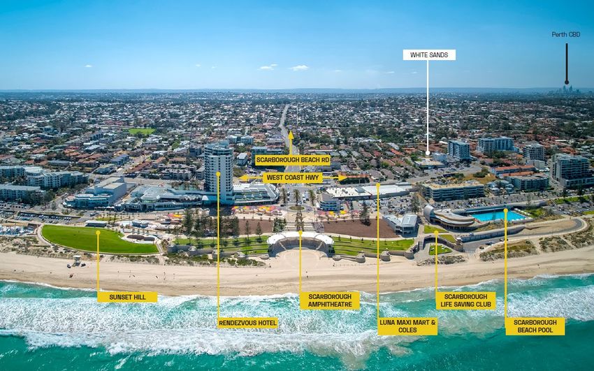
Photo Credit –
Creating
Communities

URBIS
20212701 - P004793 - WW SCARBOROUGH - AMENDED DA REPORT
1.          INTRODUCTION
This proposal presents an exciting collaboration between developer, Woolworths Group and architectural
collective – TRMJ (Taylor Robinson Chaney Broderick and MJA) to deliver a bold and iconic development on
the site of the existing White Sands Tavern, on West Coast Highway in Scarborough. We are pleased to
lodge this application for what will be a transformative development in Scarborough and a catalyst for future
development east of West Coast Highway within the Scarborough Redevelopment Area.
This application represents an amended proposal to what was previously lodged by the Woolworths Group
with DevelopmentWA in July 2020. As a result of the removal of the residential aged care component
previously proposed, it provided an opportunity to reconsider the other uses, as well as deliver a modified
built form outcome particularly to the south of the site, to respond to feedback received from the Design
Review Panel and community feedback.
This revised proposal will deliver a high-quality development and a significant contribution to the
eastern edge of the Scarborough Redevelopment Area. Importantly, it will deliver a significant uplift
to the existing rundown, underutilised site as well as density and a broad diversity of uses at the
ground level, providing a strong family offer and convenience uses much needed in Scarborough.
The development seeks to transfer gross floor area from the permitted three towers on site, to two
towers at a height of 29 and 12 stories. This apportionment of floor space delivers a far superior
outcome on site, maximising east-west viewlines, high quality landscaping and ground level
activation opportunities. It provides for a high level of residential and visitor amenity with large areas
of communal open space, landscaping and common facilities.
The proposal is an exemplary design outcome and exceeds design excellence and community
benefit outcomes sought by DevelopmentWA to justify the proposal.
This report has been prepared by Urbis, in collaboration with TRMJ and a team of technical consultants, in
support of the development application. We have undertaken a highly collaborative approach with the
community, DevelopmentWA, Main Roads WA, the City of Stirling and other relevant agencies.
We and look forward to continuing to work further with Development WA to deliver this iconic development.

1.1.        SUMMARY OF PROPOSAL
 Detail                                                   Information

 Property Location                                        Lot 1 West Coast Highway, Scarborough

 DevelopmentWA Scheme Precinct                            Beach Street Precinct (Beach Inner Core and Outer Core Sub-
                                                          Precincts)

 Use Class                                                Residential, Retail, Dining and Entertainment, Community,
                                                          Commercial

 Existing Land Use                                        White Sands Tavern, drive through liquor store, gym and parking

 Lot Size                                                 1.0165ha

 Value of Development                                     $120 million

URBIS
20212701 - P004793 - WW SCARBOROUGH - AMENDED DA REPORT                                                        INTRODUCTION   1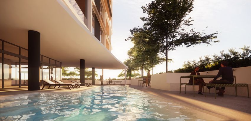
Attached to this application are a suite of supporting technical reports:

    •        Landscape Plan (Appendix B)

    •        Principles of Good Design Analysis (Appendix C)

    •        Transport Impact Assessment (Appendix D)

    •        Waste Management Plan (Appendix E)

    •        Wind Report (Appendix F)

    •        Acoustic Report (Appendix G)

    •        Stormwater Design (Appendix H)

    •        Sustainable Design Report (Appendix I)
Each of these reports confirm the capability of the proposal and are summarised in the relevant sections of
this document.

1.2.          PLANNING APPROVAL
This application seeks development approval for:

    •        Demolition of all existing improvements on site, most notably the existing White Sands Hotel.

    •        The construction of two towers, the northern tower at a height of 29 storeys and southern tower at a
             height of 12 storeys, with a 3-level podium.

    •        The following land uses:
         -      Residential
         -      Retail
         -      Dining and Entertainment
         -      Community
         -      Commercial

    •        Carparking within two basement levels and on Level 1 and 2, with a total of 671 bays, comprising
             353 residential bays and 318 staff and visitor bays, and associated bicycle parking,
             motorcycle/scooter parking and end-of-trip facilities.

    •        Associated directional and key tenant signage.
The development is proposed to be undertaken in two stages – the first being the ground level Woolworths
supermarket and retail, the second stage being the towers. The first stage will be delivered by mid-2023 with
subsequent stages to be delivered subject to demand.

                                                                                                                         URBIS
2       INTRODUCTION                                                  20212701 - P004793 - WW SCARBOROUGH - AMENDED DA REPORT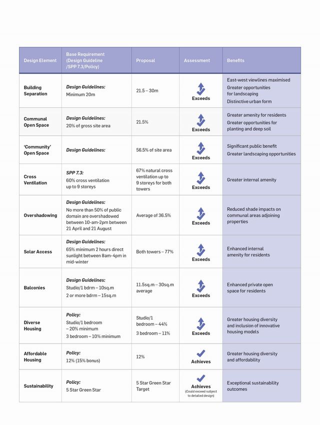
2.          THE SITE AND LOCALITY
2.1.        REGIONAL CONTEXT
The site is located within the City of Stirling local government area, approximately 11km north-west of the
Perth CBD. The site is well connected to the regional road network through direct connections to West Coast
Highway and the Mitchell Freeway via Scarborough Beach Road. The area is further serviced by high
frequency bus routes, including the 990 service that connects Scarborough Beach to Glendalough Train
station and leaves every 4-6 minutes.
The site is located within the Scarborough Redevelopment Area and is subject to the Scarborough
Redevelopment Scheme.

2.2.        LOCAL CONTEXT
Locally, the site is located on West Coast Highway, approximately 190m south of the intersection with
Scarborough Beach Road. Broadly, the land use context illustrates that the area is in transition with the
development potential afforded by the Redevelopment Scheme being progressively realised.
In terms of local contextual considerations, the following is noted:

     •    Surrounding residential development varies in form and height from single and grouped houses to
          apartments. There are also several short stay accommodation developments within the vicinity.

     •    Immediately north of the site is a series of grouped dwelling developments, and a BP service station
          on the corner of West Coast Highway and Scarborough Beach Road.

     •    The Luna Maxi Shopping Centre is located north-west of the site which was built in 1975 and
          comprises a Coles supermarket and several specialty stores. Immediately north is the Rendezvous
          Hotel, constructed in the 1980’s. Far East Organisation purchased both the Luna Maxi and
          Rendezvous sites in 2016 with plans for redevelopment.

     •    To the immediate north of Scarborough Beach Road is the former Contacio site, which was
          purchased by 3Oceans. Planning approval was obtained in mid-2018 for a mixed-use development
          comprising two towers (at 43 and 33 storeys), including 314 residential apartments and a 119-room
          hotel. Since approved, 3Oceans has amended the application, and is seeking to lodge an amended
          proposal for up to 37 storeys.

     •    To the north-west is the heart of the Scarborough Beach foreshore redevelopment, which includes
          significant foreshore enhancement including a recently constructed pool. Adjacent to the beachfront
          to the north of Scarborough Beach Road are various entertainment venues, restaurants and fast-
          food outlets. Along the beach front, beachfront hotels, bars, cafes and restaurants are located
          adjoining The Esplanade.

     •    To the south, grouped dwellings and single detached houses continue for 100m before Brighton
          Road.

     •    To the east beyond Hastings Street, grouped dwellings continue for a block before decreasing
          density to single detached dwellings surrounding Deanmore Square and Scarborough Primary
          School.

     •    To the west beyond West Coast Highway is the Seashells oceanfront short stay apartments and
          West Beach Lagoon Hotel. Beyond these accommodations, is the southern portion of the
          Redevelopment Area.

URBIS
20212701 - P004793 - WW SCARBOROUGH - AMENDED DA REPORT                                  THE SITE AND LOCALITY   3
Figure 1 – Context Plans

                                                                               URBIS
4   THE SITE AND LOCALITY   20212701 - P004793 - WW SCARBOROUGH - AMENDED DA REPORT
2.3. THE SITE The subject site is currently occupied by the White Sands Tavern, Revo Fitness and a Thirsty Camel bottleshop. The front of the site is dominated by an open, at-grade public carpark (refer images below). It fronts West Coast Highway, with a rear 20m wide battle-axe access leg to Hastings Street. The site is highly underutilised, and therefore suitable for redevelopment. Development is generally located in the central northern extent of the site. Existing buildings are in a state of relative disrepair. They are well set back from West Coast Highway and do not contribute to the street environment. Development is surrounded by carpark which is devoid of shade trees. The land gently slopes from its southern boundary to the north. The linkage between Hastings Street and the Highway functions as driveway access to the drive-through bottleshop. It is mostly unshaded and vehicular in nature. These site conditions confirm the readiness of the site for development to achieve DevelopmentWA objectives. Figure 2 - Existing Site Conditions URBIS 20212701 - P004793 - WW SCARBOROUGH - AMENDED DA REPORT THE SITE AND LOCALITY 5
This development application refers to Lot 1 West Coast Highway, Scarborough, the details of which are
provided in the table below. A copy of the Certificate of Title and Sketch is included at Appendix A.
Table 1 - Lot Details

 Lot        Diagram/Plan         Address       Vol/Folio   Area       Owner                       Encumbrances

 1          62094                Lot 1 (No.    1677/890    1.0165ha   Fabcot Pty Ltd              Sewer easement,
                                 242) West                            (Woolworths Limited)        Caveat L007927
                                 Coast
                                 Highway,
                                 Scarborough

2.4.          EXISTING ACCESS
The subject site benefits from two road frontages being:

     •      A 103m frontage to West Coast Highway to the west, with two crossovers providing one full-
            movement crossover to the north, and one to the south.

     •      A 20m frontage via battle-axe leg to Hastings Street to the east, being a local road, which connects
            to Scarborough Beach Road to the north.
West Coast Highway is a major north-south Primary Distributor road that provides access from Karrinyup
Road in the north to Claremont in the south, where it transitions to Curtin Avenue.
The site is connected to existing pedestrian and cycle networks via the shared path along West Coast
Highway and a coastal shared path. Brighton Road provides an east-west cycling link.
The subject site is well serviced by public transport through bus services. The 990 high-frequency bus route
runs from Scarborough Square, approximately 300 metres from the subject site to the Perth Busport via
Glendalough Train Station, approximately 6km south east, with Stirling Station 4m to the east. The nearest
bus stop is approximately 20m south of the subject site. The 410 bus travels along West Coast Highway and
Brighton Street, with a bus stop located at the southwest corner of the site.

2.4.1. Future Access
The Scarborough Design Guidelines identify a portion of the site fronting West Coast Highway that is
impacted by future road widening. Through discussions with Main Roads WA at the early stages of the
project, it was mentioned that West Coast Highway may be widened in the future. As such, the proposed
building setbacks and crossovers have been designed to account for this future widening to occur without
impacting the proposed development as well as allow for a left turn pocket to be constructed if required.

2.5.          SERVICING
The site is fully serviced with normal urban infrastructure that will be connected to the proposed
development.

                                                                                                                         URBIS
6        THE SITE AND LOCALITY                                        20212701 - P004793 - WW SCARBOROUGH - AMENDED DA REPORT
3. PROCESS AND ENGAGEMENT TO DATE
The Woolworths Group has undertaken significant pre-lodgement engagement as well as throughout the
statutory process of the previous application to progress the design the development as well as discussed
traffic and access, and other key matters.
This has included four Design Review Panel meetings, ongoing liaison with DevelopmentWA, Main Roads
WA and the City of Stirling, as well as a comprehensive community engagement process. Brief details of this
engagement is provided in the sections below.
3.1. AGENCY ENGAGEMENT
DevelopmentWA
The project team has maintained engagement with DevelopmentWA throughout the life of the project,
including the redesign process which has resulted in this new application. This includes numerous design
review panel presentations which is explained in Section 3.3.
Main Roads WA
Main Roads WA has been consulted in the early stages of the project, primarily with respect to access to
West Coast Highway, and continued through the statutory process.
City of Stirling
Ongoing involvement of the City of Stirling has been carried out through the initial stage of the project. This
includes briefing to Officers and Elected Members.
3.2. COMMUNITY ENGAGEMENT
In early 2019, the Woolworths Group engaged community engagement consultants Creating Communities to
undertake a stakeholder and community engagement process to inform the land uses and design for the
proposed redevelopment.
The engagement process included a number of elements including meetings with stakeholders, neighbours,
an online survey, focus groups, drop in stalls at Scarborough Beach Association events (Groundswell
Festival) and open days through the public advertising process for the previous application (in July 2020).
Overall, the engagement revealed a high level of support for redeveloping the site, as most residents and
local stakeholders rarely use the land and perceive to be old, dated and an eyesore. There was strong
support for the creation of a mix of uses including a full-line supermarket supported by a range of specialist
tenancies along with casual/shared dining spaces. Thin, setback towers were preferred by participants to
retain view lines as opposed to a ‘bulky’ medium rise development.
Other feedback included:
• Protection from/leverage off the elements should be provided, including protection from the southerly sea
breeze in summer, maximising sunlight in winter and shelter from rain all year round.
• The development should incorporate the coastal character of Scarborough, reflecting upon the
beach/surf culture and prominence of the White Sands Tavern as a popular Perth live music venue in the
70’s and 80’s, in a modern and contemporary manner.
• Enhance site access/egress including the provision of parking, in an area that is already congested,
making it easy and efficient for the local community and others to visit the development.
• The description of the proposed development in Section 4 and 5 illustrates that the proposal has
responded to this community feedback and is consistent with community expectations. This consultative
process is consistent with achieving design excellence.
Specific details of the engagement events and the feedback received can be provided upon request.
URBIS
20212701 - P004793 - WW SCARBOROUGH - AMENDED DA REPORT PROCESS AND ENGAGEMENT TO DATE 7Photo Credit – Creating Communities
URBIS
8 PROCESS AND ENGAGEMENT TO DATE 20212701 - P004793 - WW SCARBOROUGH - AMENDED DA REPORT3.3. DESIGN EVOLUTION THROUGH DESIGN REVIEW
The design of the proposal has been informed through ongoing engagement with the DevelopmentWA
Design Review Panel (DRP), with the design evolving throughout the process to respond to feedback
received. Three DRP presentations were held for the previous development application on the 11 December
2019 and 7 May and 11 August 2020.
At these meetings, the DRP advised that it considered ‘the proposal to be an exciting urban revitalisation
project for Scarborough’ however it also provided advice on a range of design-related matters for further
consideration in the progression of the design.
This feedback has been utilised to inform the re-design process, albeit a slightly modified design. A fourth
DRP meeting was held on the 8th December 2020 which presented the new proposal and articulated how it
responded to feedback received to date. A summary of DRP feedback and the changes undertaken to the
design to respond to matters raised is provided below.
DRP 01, 02 and 03
The first DRP meeting was focused on introducing the project, defining the site context and local character.
The project team highlighted the strong sense of local character within Scarborough that forms the basis of
the conceptual design process.
Across the three DRP meetings, the project team presented the evolved design which involved a northern
tower at a height of 25 storeys for residential purposes and southern tower at a height of 8 storeys,
accommodating a residential aged care facility, together with a combined podium comprising a supermarket
and associated community, retail and dining facilities.
DRP Key Recommendations
The following recommendations were provided by the DRP to the project team across the three DRP
meetings (in summary):
• Pedestrian link and legibility: A safe, legible and attractive through-site pedestrian connection is a
key component of achieving design excellence on this site. Whilst some improvement is evident, the
fundamental safety concerns remain, given a long narrow pathway adjacent to service activities with
very limited oversight.
• Massing and composition of the built form is generally supported however the impact on views,
particularly westerly views toward the beach from lots further east (and their future redevelopment),
remains a concern. The large southern tower footprint and its siting reduce tower separation and
diminish east-west views.
• Hastings Street frontage: Reduction of crossover extent (from 20m to around 15m) is considered a
positive move, however concerns remain around potential conflicts with pedestrians, cyclists, cars
and delivery vehicles.
• Podium: Upper level podium façade treatment does little to distinguish between different land uses.
There is also poor legibility and wayfinding to facilities on upper levels in the podium (ie. gym,
medical centre, child-care) if not entering via the car park.
• Resident Amenity: Location of lift core in northern tower limits opportunity for north facing
apartments.
• Sustainability and Community Offering: Any proposal to exceed ‘base’ or ‘bonus’ height should
achieve a commensurate contribution to the amenity of the area, and community and sustainability
offerings
DRP 04
The fourth DRP meeting focused on presenting the amended proposal with a specific focus on how the
design responds to key matters and concerns raised by DRP on the previous application. This primarily
includes the following:
• The southern tower has been reshaped to have a smaller footprint and more significant separation
from the northern tower and southern boundary – key concerns raised by DRP previously. The
shape and orientation of the towers have been sculptured to provide quality solar ingress to
apartments and communal areas while also limiting viewlines between the towers and
overshadowing to adjacent sites.
URBIS
20212701 - P004793 - WW SCARBOROUGH - AMENDED DA REPORT PROCESS AND ENGAGEMENT TO DATE 9• The loading dock has been pulled back from the north and east boundary to allow for a 5m width
along the north and a ‘green zone’ to the Hastings Street end.
• The northern tower lift core has been relocated to sit central to the tower allowing for additional
northern aspects to apartments and more efficient circulation.
DRP Feedback
While formal minutes were not received prior to the lodgement of this application, the following anecdotal
feedback was recorded by the project team and was considered as part of the finalisation of the design and
application:
• Further justification required to justify the 29-storey height, in particularly what the development is
delivering over and above what is required from a planning perspective.
• Consideration required as to how design responds to community feedback received as part of the
previous community engagement and statutory advertising process.
• It would be helpful to present a broader height analysis for the area and clarify how the proposed
heights sits within this broader framework.
• Review apartment layouts and balconies sizes to ensure compliance with Design Guidelines.
• Design of towers to address sun, wind, shading and materials.
• Clarity regarding sustainability and recommended a commitment to achieving 5 Star Green Star.
The above feedback has been closely considered as part of the finalisation of the design and lodgement of
this application. Specifically, Section 5 of this report provides substantial justification for the proposed height
transfer across the site, including where it exceeds design excellence parameters, its significant community
benefit as well as an analysis of the broader area in terms of height.
Further, the design report at Appendix C explains the rationale behind the tower design and, together with
the detailed planning assessment against the Design Guidelines, explaining how it meets requirements with
respect to overshadowing, solar access and wind control.
URBIS
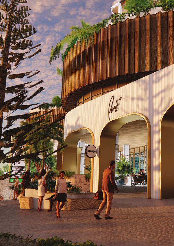
10 PROCESS AND ENGAGEMENT TO DATE 20212701 - P004793 - WW SCARBOROUGH - AMENDED DA REPORT4. THE PROPOSAL 4.1. ARCHITECTURAL STATEMENT ‘The future White Sands Tavern site will be a thriving local centre – providing convenience, dining and community uses as well as residential density in the form of a combined podium and two iconic towers. The uses and design reflect the context of Scarborough, with historical references to beachside architecture and former uses in the area to create high levels of social activity, as well as a sense of fun and relaxedness that can be associated with the local coastal lifestyle. The ground plane will be an active and inviting space, increasing accessibility in the local area through an attractive and highly landscaped pedestrian access way connecting Hastings Street and West Coast Highway. Active ground floor dining, retail and community uses will spill out into common areas, providing opportunities for social interaction. The curvature of the local dunal topography and arterial roads have been consistent Scarborough landmarks over time and have been represented in the curved undulating forms and convex curves of the proposed towers. The concept for the white ‘net’ to the northern tower was derived from fishing nets brought to the beach by the ocean and encasing the sand. This net is then raised to form a ‘crown’ on top of the residential tower, which will be an iconic feature among the developing Scarborough coastline. Soft edges are provided to the towers, with curves and open balconies reminiscent of the dunal, coastal landscape in a ‘bowtie’ shape. The use of roof and podium areas have been maximised for planting on structure and communal open space, creating multiple ground planes and an attractive fifth elevation from upper levels. Historical beach shading shelters are represented in the fine framing detailed of the northern tower, and the folded metal edges of the sun screening detail. Materials reflect a neutral palette, referencing various sandy whites, light coloured local stone, textural and bleached timbers, as well as bronze metals. Bronze coloured sunscreens capture afternoon light, creating golden edges, with screening elements to the western façades to address prevailing weather conditions’. URBIS 20212701 - P004793 - WW SCARBOROUGH - AMENDED DA REPORT THE PROPOSAL 11
4.2.        DEVELOPMENT SUMMARY
The site is proposed to be comprehensively redeveloped for the purposes of an integrated mixed-use
development. A summary of the key components of the development include:
Table 2 – Development Summary

 Item                 Number/Provision

 Towers               Two towers

                          •    Northern tower – 29 storeys (3 level podium)

                          •    Southern tower – 12 storeys (3 level podium)

 Residential Yield    302 apartments – 225 in northern tower and 77 in southern tower

 Residential          Northern Tower (225 apartments)
 Dwelling Mix         1x1 – 100 (44.5%)

                      2x2 – 100 (44.5%)

                      3x2 – 25 (11%

                      Southern Tower (77 apartments)
                      1x1 – 33 (43%)

                      2x2 – 36 (47%)

                      3x2 – 8 (10%)

 Non-Residential          •    Woolworths supermarket – 3,800sq.m
 Land uses and            •    Liquor store – 195sq.m
 Floorspace
                          •    Food and Beverage – 785sq.m

                          •    Retail – 375sq.m

                          •    Medical Centre – 900sq.m

                          •    Gym – 740sq.m

                          •    Commercial (office) – 1,830sq.m

                          •    Child Care – 1,070sq.m (72 children)

                      The precise use of the other retail/commercial tenancies is yet to be determined but they will
                      accord with the preferred and contemplated land uses for the site as outlined in the
                      Scarborough Redevelopment Scheme.

 Landscaping/Public   Landscaped pedestrian access way linking West Coast Highway and Hastings Street
 Realm Elements       Deep soil and planting on slab – 1,742sq.m 17.1% of site.

 Car, Bicycle and     Carparking – 671 bays:
 Motorcycle Parking       •    353 resident bays

                          •    318 retail/commercial visitor bays

                      Bicycle parking – 330 bays (275 residential, 55 commercia/visitor)

 Communal             Podium level communal open space – 2,196sq.m (22%)
 Facilities           Pedestrian access way

 Signage              A range of high level and street level signage, located centrally and externally to the
                      development, to assist in identifying tenants (primarily Woolworths and BWS), and providing
                      direction and way finding.

                                                                                                                         URBIS
12     THE PROPOSAL                                                   20212701 - P004793 - WW SCARBOROUGH - AMENDED DA REPORT
Item Number/Provision
Public Art Public art is proposed for the walls that frame the PAW from Hastings Street to West Coast
Highway, along with Levels 1 & 2 of the west-facing perforated screens (see drawing SK20
elevations in the development application plan set) facing West Coast Highway.
4.3. LANDSCAPE STRATEGY
A landscaping plan has been prepared by CAPA and attached at Appendix B. The landscape strategy for
the proposal has been based on extensive context and site analysis and is premised upon the vision and key
objectives of the Scarborough Master Plan, which is to protect and create connections, landscape layering,
vistas and refuge.
Key components of the ground floor landscape strategy include provision of an attractive street level
interface with West Coast Highway that provides amenity for urban infrastructure including street trees,
benches and cycle racks. It also focuses on delivering a high quality, new public accessway from Hastings
Street to West Coast Highway which will be attractive and welcoming. These landscape strategies will be
expressed through:
• Native planting to the verge to provide soft and undulating edge in contrast to West Coast Highway.
• Native cascade planting to podium levels to also provide layering to edges to street.
• Norfolk Pines planted on the site will ultimately become verge trees post road widening.
• Tree Grove of feature palms to ground and terrace levels.
• Prostrate coastal plantings to spill over edge of undulating walling.
These strategies will combine to create attractive spaces that reflect and respond to setting, enhance
security and help to activate public edges. In the case of the eastern boundary, the landscape will contribute
to a shared entry that clearly caters to pedestrians.
Private open spaces have also been carefully designed to reflect the needs of those spaces as well as their
setting. These areas include the play area for the child-care centre which incorporates shade trees,
windbreaks, synthetic play surfaces, safety fences and screening and a playground.
The development includes key communal landscape features and areas including:
• A green pedestrian link connecting Hastings Street and West Coast Highway.
• A highly landscaped West Coast Highway verge (within designated road widening area), with
planting of mature trees.
• A western alfresco area at colonnade level.
• Communal spaces within the residential tower developments including resident terrace areas,
gardens, pool areas (refer images below).
• Outdoor lagoon play space for the child-care facility.
These areas combine to create a development that is people-oriented – it provides for a range of community
needs from areas of quiet contemplation to social connection and physical exertion. These communal areas
also help to activate various levels of the development and break up visual bulk. Access to sunlight and fresh
air is encouraged and the towers have been designed specifically to maximise this.
Extensive green spaces support mental and physical well-being which is an important factor when
considering design excellence. It is also worth noting that the functionality and comfort of green spaces on
the southern portion of the site is assisted by the taller, slender building proposed to the north which
increases sunlight access compared to
All landscape elements have been designed to reflect the recommendations of the Wind Study, minimise
maintenance, minimise water use and ensure a thriving landscape.
URBIS
20212701 - P004793 - WW SCARBOROUGH - AMENDED DA REPORT THE PROPOSAL 13URBIS 14 THE PROPOSAL 20212701 - P004793 - WW SCARBOROUGH - AMENDED DA REPORT
4.3.1. Deep Soil and Planting on Structure
The development proposes both deep soil areas and planting on slab as follows:
• Deep soil areas – 407sq.m (4%)
• Planting on structure – 1,335sq.m (13.1%)
• Total – 1,742sq.m (17.1%)
Consistent with State Planning Policy No.7.3, where 10% deep soil cannot be provided on site, there is
flexibility to consider planting on structure with an area equivalent to two times the shortfall. In addition, 10
large trees and more than 90 small trees are proposed – concentrated within the West Coast Highway verge
area, the entrance from Hastings Street as well on within Level 2 and 3 communal areas.
Figure 3 - Deep Soil and Planting on Structure Areas (CAPA Landscape Report)p
URBIS
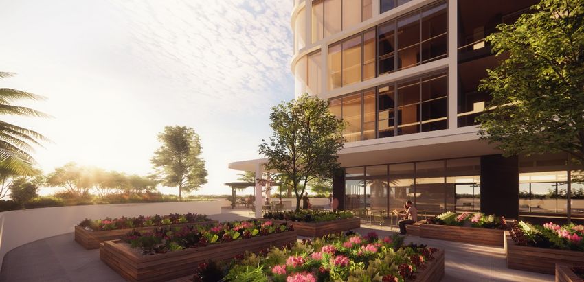
20212701 - P004793 - WW SCARBOROUGH - AMENDED DA REPORT THE PROPOSAL 154.4. PEDESTRIAN ACCESS WAY
A Pedestrian Access Way (PAW) has been incorporated into the development along the northern boundary
of the site, offering public amenity by providing a safe and compliant public pedestrian connection between
West Coast Highway and Hastings Street. This meandering pathway integrates access to the primary
residential address point and (operating over two levels) allows a traverse both via the activated ground
plane and alongside the undercroft parking.
The design incorporates design language and materiality that is consistent throughout the landscape design,
with low level planting, trees, lighting and wayfinding signage. The meander makes the pathway interesting,
particularly as, along its length, the design integrates various ‘pockets’ of landscaping.
The walkway is purposefully partly covered and partly open, allowing for landscape to thrive and general
access to daylight and sun. Being located along the northern edge the user is protected from the prevailing
south west winds. Any overhead structures will be a combination simple awnings and ‘pergola’ type
structures (with integrated landscape and lighting).
The PAW will also be the ‘canvas’ for public art installations that can be integrated with the proposed lighting
strategy, both as painted artwork, and sculptural pieces – some of which may form part of the architecture of
the pergolas and awnings. This work and its artistic themes / content is yet to be finalized, and as such,
examples shown on the attached Development Application drawings are indicative and/or placeholders.
A design rationale and detailed description of this public accessway is included within the design report at
Appendix C.
4.5. TRAFFIC, PARKING AND ACCESS
Cardno was engaged to prepare a Transport Impact Assessment in relation to the proposed development. A
summary of key transport, parking and access considerations for the proposed development is provided in
the sections below (with a copy of the full Assessment provided at Appendix D).
4.5.1. Vehicle Access
Vehicular access is via two crossovers to West Coast Highway and a crossover to Hastings Street. This
maintains the existing number of crossovers to the site, albeit with a minor change to the western crossover
locations. No substantial road upgrades are necessitated by the proposal. Crossover arrangements are
summarised in the table below:
Table 3 – Proposed Access Arrangements
Access Arrangement
South-West on West Coast Left-in, left-out and provides access to the residential carparking on
Highway (Access 1 in TIA) Levels 1 and 2 as well as access for residential waste collection.
North-West on West Coast Left-in, left-out and right-in only and provides access to the main
Highway (Access 2 in TIA) commercial carparking. The existing right-turn pocket will be extended to
match the new access location as shown in the TIA.
North-East on Hastings Full movement access onto Hastings Street and provides access for
Street (Access 3 in TIA) commercial tenants and visitors as well as loading dock access. The
proposed access is 14.5m wide which is the minimum width required to
accommodate the movement of a 19.0m semi-trailer entering and exiting
the loading dock.
URBIS
16 THE PROPOSAL 20212701 - P004793 - WW SCARBOROUGH - AMENDED DA REPORT4.5.2. Car, Bicycle Parking and End-of-Trip Facilities The development proposed 671 carparking bays which complies with Development WA requirements. Of these bays, 353 are dedicated for residential tenants and the remaining 318 bays are to be used by staff and visitors, and the general public. The TIA includes a parking demand and supply analysis which identified the predicted demand to be 266 bays during the weekday peak and 302 bays at the weekend peak. On this basis, the carparking complies both from a statutory and demand perspective. A total of 330 bicycle parking spaces are provided - 275 for residential tenants and 55 for visitors and staff (comprising 30 u-rails on the ground floor and 25 secure bays within the end-of-trip area on Basement 2). Bicycle parking for visitors is provided in convenient locations along the development frontage, with residential parking located within allocated storage areas. While this presents a shortfall to DevelopmentWA requirements, the residential bicycle parking provision is aligned with State Planning Policy No.7.3 and is based on actual demand and utilisation rates. Further justification for the bicycle parking provision is provided within Section 3.4 of the TIA. Similarly, an alternative to DevelopmentWA end of trip facilities has been provided – Woolworths will provide a shower for its staff consistent with its standard practice, two male and female showers for remaining tenancies will be provided. 4.5.3. Waste and Service Vehicle Access Waste collection and delivery movements will occur via the Hastings Street crossover. Trucks can enter and exit the site in forward gear. Waste collection for the residential and removalist trucks (7.5m waste collection trucks) for the southern tower will enter from Access 1 at West Coast Highway. 4.5.4. Traffic Analysis The proposed development is estimated to generate approximately 696 vehicles during the weekday AM peak hour, 663 vehicles during the weekday PM peak hour and 719 vehicles during the weekend peak hour. This includes a proportion of ‘pass by’ trips which are trips already on the road network and divert into the site. The traffic analysis presented within the TIA confirms that the existing signalised intersections on West Coast Highway are currently operating at or in excess of practical capacity during the peak periods and will deteriorate further as background traffic increases in the future. The traffic generated by the development has a minor impact on the performance of these intersections and does not generate a warrant for upgrades beyond those already warranted by existing and background traffic growth. The proposed access arrangements effectively distribute traffic to/from the surrounding road network, with the ability for regional trips to directly enter/exit from West Coast Highway and local trips to use Hastings Street. Any change to these access arrangements would result in a worsening of performance at the two signalised intersections as additional traffic would be added to the already congested turning movements at these locations. URBIS 20212701 - P004793 - WW SCARBOROUGH - AMENDED DA REPORT THE PROPOSAL 17
5.            DESIGN EXCELLENCE AND COMMUNITY BENEFIT
The Design Guidelines encourage the pursuit of design excellence across the Redevelopment Area. The
applicable base height for the site under the Scarborough Design Guidelines is predominantly 12 storeys
with potential for 18 storeys dependent on design excellence being achieved in addition to achieving certain
criteria outlined in the Design Guidelines. It is also open to DevelopmentWA to approve height beyond 18
storeys depending on the design proposed.
In this case, design excellence has been achieved to contribute to the justification for approval of the
northern tower above the base height to 29 storeys. The sections below illustrate that the proposal exceeds
the requirements from a design excellence and community benefit perspective to warrant the transfer of
height and plot ratio across the site. A comprehensive design report which expands on these various matters
is provided at Appendix C.

5.1.          HEIGHT ANALYSIS AND TRANSFER
In considering the overall developability of the site from both a spatial and statutory compliance perspective,
it is highlighted that a third tower could be accommodated on site with appropriate setbacks. The third tower
would be located on the Hastings Street leg, where the Design Guidelines prescribe an 8-storey height, with
bonus provisions to achieve 12 storeys.
In comparing this scenario with the proposed development (which is for two towers concentrated towards
West Coast Highway), the following development outcomes could be achieved.

     •      Alternative Complaint Scenario (3 towers) – total of 34,120sq.m over 48 storeys collectively (18, 18
            and 12 storeys).

     •      Proposed Scenario (2 towers, current proposal) – total of 31,169sq.m over 41 storeys collectively (29
            and 12 storeys).

Clearly the proposed application is the preferred outcome from an urban design perspective. It represents
the transfer of overall floor area and height which is permissible on site (inclusive of bonuses) from the 48
storeys potentially allowed under the three-tower scenario, to 41 storeys collectively across two towers.
Importantly, this proposed scenario delivers the following design benefits:

     •      The sense of building separation is enhanced which positively impacts on the perception of mass
            and diversity of form.

     •      Providing variance in proportion to the two towers creates more mass variation and along the
            streetscape. In particular, the reduction in height follows a logical transition from the Beach Road
            Inner to Beach Road Outer sub-precinct,

     •      Viewlines are maximised east-west due to the ability for greater tower separation and a lesser
            footprint (also compared to the previous development application, as shown in the figure below).

     •      Cross-views between apartments towers are reduced (in comparison to two 18 storey towers).

     •      Placing additional height in the north-western corner of the site limits overshadowing to neighbours.

                                                                                                                          URBIS
18       DESIGN EXCELLENCE AND COMMUNITY BENEFIT                       20212701 - P004793 - WW SCARBOROUGH - AMENDED DA REPORT
• The northern tower will have the best climatic conditions for podium level amenity spaces – there is
therefore benefit in maximising apartment numbers within this tower from an occupant amenity
perspective.
• The design considers both the existing and future context of Scarborough as well as other proposals
being progressed in parallel.
• It allows for enhanced landscaping opportunities to Hastings Street and throughout the pedestrian
access way.
• It reflects the outcomes of community consultation in that many participants had a desire to see
slender towers with greater setbacks than medium rise bulky developments. The greater height
results in a slender structure and reduces overall bulk and scale.
Further, the reconfiguration of the southern tower from the previously lodged proposal to reduce building
bulk, achieve greater tower separation, achieve greater setbacks to the southern boundary and maximise
views. Specifically, tower separation has been increased from 14.2-17.3m (and 7.5m setback to southern
boundary) in the previous application to 21.5-30.0m (and 7.0 – 16.0m setback to southern boundary) in this
current proposal. This is now compliant with the Scarborough Design Guidelines.
Figure 4 - Comparison of Viewlines
The proposed height is in keeping with the future surrounding built form and height context within the
Scarborough Redevelopment Area. The proposal, which includes two towers at 29 and 12 storeys, sits
comfortably from a height perspective in the context of the following:
• 3 Oceans site (to the north) with existing approval for up to 43 stories (and anecdotally understood a
revised proposal will be lodged at 37 storeys).
• Lot 2 Manning Street (to the south) at up to 24 storeys.
• Other remaining development sites which are permitted to build to 18 storeys (with variation to
exceed this under the planning framework).
URBIS
20212701 - P004793 - WW SCARBOROUGH - AMENDED DA REPORT DESIGN EXCELLENCE AND COMMUNITY BENEFIT 195.2. BONUS HEIGHT PROVISIONS
Consistent with Section 4.1 of the Design Guidelines, the proposal exceeds requirements to develop over
the 12-storey base height. While only one of the criteria is required to be achieved under the planning
framework, the proposal achieves 4 of the 6 criteria outlined, specifically the following:
Target of 5 Star Green Star.
Provision of a publicly accessible pedestrian accessway from Hastings Street to West Coast
Highway.
Provision of a public car parking in excess of 100 bays.
Provision for 513sq.m road widening along the western site boundary which is being utilised to
maximise soft planting along the streetscape. When the northern pedestrian access way is
included, the extent of land given over to road widening and access improvements exceeds 10% of
the site area.
Further, while 12% affordability is achieved (in lieu of 15% bonus criteria) it should be highlighted that the
developer is considering innovative housing models (such as build-to-rent) which will provide an alternative
form of affordability and diversity well-suited to the Scarborough locality.
While, strictly speaking, this does not meet the definition of affordable housing, it should be given due
consideration as an alternative affordable housing product which has emerged since the preparation of the
planning framework for Scarborough that will deliver significant benefit for the area.
5.3. DESIGN EXCELLENCE
Consistent with the Design Guidelines and to illustrate design excellence, the following process and
outcomes have been adopted:
Adherence to the principles of good design defined in State Planning Policy 7.0 – Design of the Built
Environment. A statement outlining the architectural approach has been included at Appendix C. It
provides design commentary in the context of the 10 principles of good design contained in SPP7.0
– Design of the Built Environment and explains the process and outcomes that have led to the
current proposal achieving design excellence
Design based on exemplary site analysis.
Analysis and design response discussed at pre-lodgement meetings with DevelopmentWA and
subject to a formal design review process (refer Section 3.3).
Design includes responses to prevailing wind, existing and desired future character of the
streetscape, public domain interface, topography, retained and proposed significant trees and deep
soil zones, orientation of site and potential overshadowing, and significant views to and from the site.
Design undertaken by Registered Architects (Taylor Robinson Chaney Broderick and MJA Studios)
who are leaders in the architectural design of retail/commercial and residential buildings and spaces.
All areas of open space are to be designed by Registered Architects/Landscape Architects (CAPA).
A comprehensive summary of the proposals level of design excellence is provided at Appendix C, with a
snapshot of how the design exceeds key design parameters provided in the graphic below.
URBIS
20 DESIGN EXCELLENCE AND COMMUNITY BENEFIT 20212701 - P004793 - WW SCARBOROUGH - AMENDED DA REPORTTable 4 - Design Excellence Summary URBIS 20212701 - P004793 - WW SCARBOROUGH - AMENDED DA REPORT DESIGN EXCELLENCE AND COMMUNITY BENEFIT 21
5.4.        COMMUNITY BENEFITS
In addition to design excellence and the proposed exceedance of key design requirements, the development
will deliver exceptional community benefit as illustrated below. These benefits are consistent with Section 2.8
of SPP 7.3 which outlines a range of examples of community benefit that may be considered in exchange for
additional development potential.

 Over 5,700sq.m ‘community’             A diversity of uses –            Affordable housing              Universal residential design
  open space that locals and        including a full line market-    provided in the form of 1, 2      through delivering 20% Liveable
 visitors can enjoy, including       style supermarket, liquor       and 3-bedroom apartments             Housing Silver compliance.
   a high-quality landscaped           store, retail/specialty
     pedestrian access way          shops, medical centre, gym
  linking Hastings Street and         and childcare – all uses
      West Coast Highway.            needed in the local area.

    Significantly improved          Public parking facilities that          Combination of              Provision of 30 visitor/public
  streetscape to both West            broader visitors to the              architectural and            bicycle parking spaces along
 Coast Highway and Hastings           Scarborough area can           landscaped elements used          West Coast Highway, with easy
            Street.                            utilise                 to reduce the impact of         universal access to the centre.
                                                                          wind on the public
                                                                        functions facing West
                                                                           Coast Highway.

       A variety of vertical         Click and collect shopping      A significant contribution to    The design can cater to the future
  circulation options for users        provisions – providing         local tree canopy via the          provision of electric vehicle
      to move between the            enhanced convenience to         green spaces and amenity          parking and charging facilities.
      different levels of the            locals and visitors.                 proposed.
             podium.

  Provision for future FOGO             A strong and visually          Considerable dwelling           Public spaces to be well lit with
  (food/organics) waste has         interesting design aesthetic           diversity, with             good passive surveillance from
  been proposed within the              delivering a positive        consideration of innovative         West Coast Highway and
  waste management plan.             contribution to the locality.    housing models such as                   Hastings Street.
                                                                           build-to-rent.

                                                                                                                                URBIS
22     DESIGN EXCELLENCE AND COMMUNITY BENEFIT                               20212701 - P004793 - WW SCARBOROUGH - AMENDED DA REPORT
You can also read