Thanington Parish Council Neighbourhood Plan - Draft -Published 04/05/2021
←
→
Page content transcription
If your browser does not render page correctly, please read the page content below
Thanington Neighbourhood Plan 2020

  Thanington Parish Council
    Neighbourhood Plan
                                     Draft —Published 04/05/2021
Thanington Neighbourhood Plan 2020

            Table of Content
            Table of Content                                                     Page 2
            Executive Summary                                                    Page 3-5
            Introduction                                                         Page 6
            Objectives                                                           Page 7
            Area covered by Neighbourhood Plan                                   Page 7

            How this Neighbourhood Plan works & maybe read                       Page 8
            Statement of Local Authority notification                            Page 8-10
            Objective A. Support Local Associations                              Page 11
            Objective B.. Conserve the Natural and Historical Enviroment         Page 12-18
            Objective C. Sustainable Transport                                   Page 19-28
            Objective D. Promoting Healthy Communities                           Page 18
            Objective E. Quality of Life                                         Page 19
            Objective F. Conserving and Enhancing the Natural Environment        Page 33-41
            Ancient Woodland and SSSI                                            Page 42
            The Consultation Statement                                           Page 43-44
            Questionnaire Results                                                Page 45
            Public Comments                                                      Page 45-46
            Questionnaire Graphs                                                 page 47-48
            Conformity Test                                                      Page 49
            Canterbury District Local Plan
                  Strategy—Housing—Employment                                    Page 50
                  Town Centre & Leisure—Transport Infrastructure                 Page 51
                  Tourism and Visitor Economy                                    Page 52
                  Climate Change, Flooding, Coastal Change and Water Resources   Page 52
                  Design and the Built Environment                               Page 53
                  Historic Environment - Landscape and Biodiversity              Page 53
                  Open Spaces                                                    Page 54
                  Quality of Life    - Appendices                                Page 56
                  Thanington LDP cross refs with CDLP Policies                   Page 57
                  Neighbourhood Plan Committee Members                           Page 58

2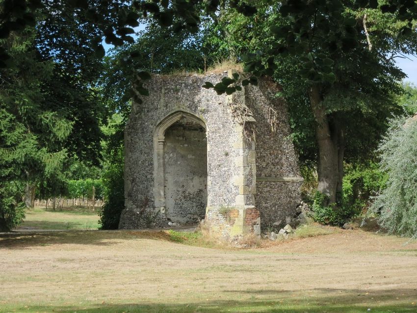
Thanington Neighbourhood Plan 2020

          EXECUTIVE SUMMARY (draft 3-5-21)
          This Executive Summary of the Neighbourhood Plan, is a summary of the vision for improving and
          sustaining Thanington, for current residents, future residents and visitors, both now and in the
          future. The Neighbourhood Plan has been coordinated and written in conjunction with residents
          of Thanington, and other bodies, by Thanington Parish Council. (TPC)
          It takes the four key objective areas in the Neighbourhood Plan. it describes the current situation
          for these, and also lays out a vison for the future in these key objectives. Taking into account the
          recent and proposed development planned in Thanington. It lays out aspects that should be con-
          sidered in these objectives for any future as yet unplanned developments by the Local Authority,
          Canterbury City Council (CCC), and the District Authority, Kent County Council (KCC)
          The sections below summarises the points made in the Neighbourhood Plan for Thanington, par-
          ticularly the key four objectives. It covers each objective in turn.

          SUMMARY POINTS BY OBJECTIVE:
          1/ TO PROMOTE A HEALTHY COMMUNITY

                                           TO BE COMPLETED

          2/ TO CONSERVE THE NATURAL AND HISTORICAL ENVIROMENT
          Key points:
          Landscape & Biodiversity:
              Maintain the level of green space available including allotments
              Maintain and protect open spaces
              Only developments that can show true environmental sustainability should be progressed
                 with
              Support and maintain the Green Gap policy
              Maintain and support land used for agricultural use
              Support independent surveys on the impact of development on the natural environment
              Protect Historical sites and assess the true impact of any proposed development on them.

          Visual Impact:
              Genuine consideration and assessment should be given to the visual impact of any develop-
                 ment including on historical sites

          Light & Noise Pollution:
              Light pollution on the overall area must be considered in any development proposals
              The impact of noise pollution caused by and proposed development must be given genuine
                  consideration

                                                                                                           3
Thanington Neighbourhood Plan 2020

            Climate Change:
                The flood risk area along the lower Stour must not be increased by any development and
                    must be genuinely assessed by associated agencies.
                Air pollution particularly along the A28 must not be increased by any proposed developments
                    and genuinely assessed if necessary by independent assessment.
                Acton should be taken to decrease the level of air pollution when considering air pollution
                    from any development
                Any development should be designed to be carbon neutral.
                The impact on utility services, like sewage and drainage, also assessed and genuinely mitigat-
                    ed for in the planning assessment

            3/ TO PROMOTE SUSTAINABLE TRAFFIC AND TRANSPORT INFRASTUCTURE
            Key points:
            Modal Shift Transport systems:
                The local bus services, including the Park & Ride at Wincheap, need to give consideration re-
                   garding the service provided to the rural areas of the Community. Such that they can be
                   easily accessed in an efficient way that provides a reliable service encouraging proactive
                   use.
                New developments must give serious provision for these services that support this general
                   strategy
                Cycle ways and walkways must be maintained, preserved, and expanded to encourage their
                   effective use. New developments should not have a negative impact on their use, but
                   have genuine design inclusions for this in their planning.
                Measures such as secure cycle storage and parking should be considered and included in any
                   development proposals and also in the existing network. Thereby encouraging short dis-
                   tance cycling.

            Parking & Traffic:
                Any new development must have genuine assessment made on its impact on traffic. Prefera-
                    bly with an independent assessment made of that overall impact both local and outside
                    the development area . Not just a parochial approach on the individual development.
                New development should include all measures to reduce the increase and impact on traffic.
                    This must include infrastructure improvements.
                The local community views and knowledge must be considered regarding traffic impact when
                    considering development applications.
                The impact of parking, and the provision of sufficient parking spaces on any development
                    must be given sufficient consideration particularly any impact on local existing area park-
                    ing. There is evidence of lack of parking provision in modern developments.
                When considering car parking, measures such as vehicle charging points, should be included
                    in both existing development areas and also new developments.
                The consideration of YELLOW LINE designated areas on the road network should be consid-
                    ered and if necessary used, to ensure safe and effect use of the road network
                Traffic mitigation measures regarding any proposed development must be provided at a time
                    that deals with the issues upfront and in a way that guarantees their delivery.

4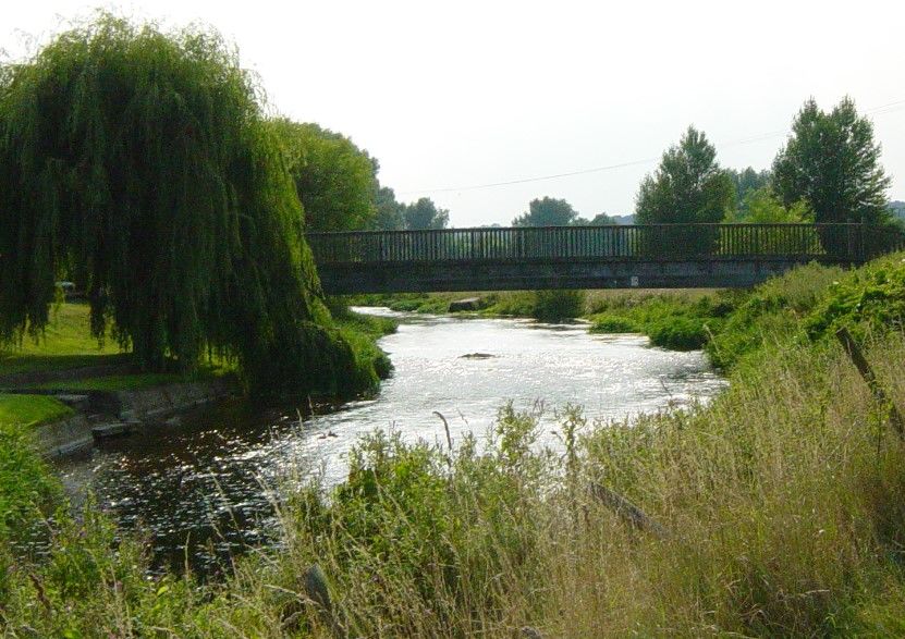
Thanington Neighbourhood Plan 2020

          4/TO PROMOTE SUSTAINABLE DEVELOPMENT THAT DELIVERS FOR THE COMMINI-
          TY THE PROMISED BENEFITS OF THAT DEVELOPMENT

                                     TO BE COMPLETED

                                                                           5
Thanington Neighbourhood Plan 2020

            1 INTRODUCTION (24/4/21)
            1.1 This Neighbourhood Plan sets out the vision for Thanington Parish until 2035. It enables us to
            set out policies to help achieve that vision under the provision of the localism Act 2011, and in
            accordance with the Canterbury District Local Plan 2017-2031 and the National Planning Policy
            Framework 2019.

            The Vision for the Parish of Thanington and its objectives are to:

                        THANINGTON NEIGHBOURHOOD PLAN MISSION STATEMENT :
                            Maintain Thanington as a unique identifiable entity, so
                     supporting the wishes of all aspects, and areas of the community .
                        Thereby ensuring a healthy and thriving community in which
                                Its occupants can thrive and prosper in their lives

            1.    Promote a healthy community
            2.    Conserve and enhance the natural environment
            3.    Conserve and enhance the Historic environment
            4.    Help and promote Thanington community Associations & charities
            5.    Engage with the District LOCAL AUTORITIES. Canterbury City Coun-
                  cil (CCC) , Kent County Council (KCC) & Kent Highways (KH) on
                  traffic issues in all parts of the community.
            6.    Ensure agreed developments deliver the promised resources and
                  other mitigation factors in 106 agreements
            7.    Work to keep transport links at a good frequency. These include
                  Bus services Taxi Services, and possible locally organised transport
                  services
            8.    Help maintain the living standards and health of the community by
                  controlling development. To ensure new development contributes
                  to the health and living standards of the community, and also
                  meets the highest standards required.

6
Thanington Neighbourhood Plan 2020

          OBJECTIVES
          1.2 The Thanington Neighbourhood Plan (TNP) objective sections are listed below and the NP
          deals with each of those section as individual discrete sections.
          They are:
          a)    TO PROMOTE A HEALTHY COMMUNITY
          b)    TO CONSERVE THE NATURAL AND HISTORICAL ENVIROMENT
          c)    TO PROMOTE SUSTAINABLE TRAFFIC AND TRANSPORT INFRASTUCTURE
          d)    TO PROMOTE SUSTAINABLE DEVELOPMENT THAT DELIVERS FOR THE COMMINITY THE
                PROMISED BENEFITS OF THAT DEVELOPMENT
                                                                                        st
          1.3 Thanington Neighbourhood Plan (TNP) policies shall be in effect until 1        September 2035.
          1.4 To present the TNP to the Local Authority for Canterbury (CCC) for ratification in a timescale
          that allows CCC time to develop their LDP

          AREA COVERED BY THE THANINGTON NEIGHBOURHOOD PLAN

                                                                                                               7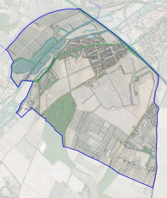
Thanington Neighbourhood Plan 2020

            How this Neighbourhood Plan works & maybe read:
            1.5 To work through this plan we have labelled the objectives into sections and numbered the
            policies. These will be the guiding principles for any future development within the parish during
            the time frame of the TNP.
            When reading each section:
            The OBJECTIVES are highlighted and numbered in blue.

                                                    Canterbury District Local Plan Policies:

                          Shaded in yellow are the relevant Canterbury LP Policies for each objective of the TNP plan

                  Proposals relevant to each objective and objective section are highlighted in green

                  Also listed with each proposal is the relevant Canterbury LP Policy reference

            There is an EXECUTIVE SUMMARY included within the TNP providing a summary of its key points.

            STATEMENT OF LOCAL AUTHORITY NOTIFICATION
            The application has been submitted by the Parish Council in accordance with the relevant
            legislation and guidance. The area designation covers the whole parish area (see para.2 above)
            and therefore non-designation by the City Council would be contrary to legislation and na-
            tional planning guidance.

            6.2 Given that under Regulation 5A applications for designation of a whole Parish as a
            Neighbourhood Area must be approved without any modification and no consultation is re-
            quired, it is recommended to Full Council that delegation be given to the Chief Executive to
            designate a neighbourhood area, if the proposal is made under Regulation 5A of the
            Neighbourhood Planning Regulations (2012) (as amended).

            7.        Implications

            (a) Financial - once this neighbourhood area has been designated, the local planning
            authority can then apply for a £5,000 grant from the government to support the Council’s
            work towards this Neighbourhood Plan.
            (b) Legal - Localism Act 2011; Neighbourhood Planning (General) Regulations 2012 (as
            amended) and Planning Practice Guidance, in particular Paragraph: 024 Reference ID: 41-024-
            20190509 Paragraph: 025 Reference ID: 41-025-20190509 Paragraph: 032 Reference ID: 41-
            032-20170728 Paragraph: 035 Reference ID: 41-035-20161116

            (c)       Equalities - none identified

8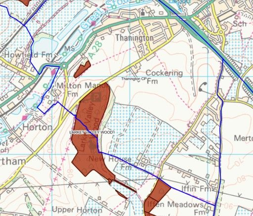
Thanington Neighbourhood Plan 2020

          (d)     Environmental including carbon emissions and biodiversity - none identified
           Other implications
                  (e) Staffing resource - Within current levels of staffing
                   (f)   Property portfolio - none identified
                   (g)   Planning including building regulations - as (b) above
                   (h)   Human rights issues - none identified
                   (i)   Crime and disorder - none identified
                   (j)   Safeguarding children - none identified
                   (k)   Heritage - none identified

          8.      Conclusions

                          Thanington Parish Council has submitted an application to designate the
                          whole parish as a Neighbourhood Area. This is the first step in the community pre-
                          paring a Neighbourhood Plan for Thanington. In accordance with legislation and
                          government guidance, it is recommended that the Neighbourhood Area be desig-
                          nated.

                          8.2 It is also recommended that delegated authority to designate a whole parish
                          area (a Regulation 5A application) be given to the Chief Executive. This is
                          because Regulation 5A applications must be approved without scope for any mod-
                          ification and do not require consultation.

          Decision Maker: Policy and Resources Committee
          Decision status: For Determination
          Is Key decision?: No

          Decisions:
          Report author: Karen Britton
          Publication date: 15/10/2020
          Date of decision: 05/10/2020
          Decided at meeting: 05/10/2020 - Policy and Resources Committee

          BACKGROUND
          1.6 Thanington is a civil parish proximity 2 miles from city centre by road, and a suburb outside
          the city walls.
          It covers a large area SSW of Canterbury of 4.8 sqkm (1.9sqmi), and has a population of 2662 resi-
          dents (2011 parish census), 1055 households, and still growing. It extends to the south–west of the A2
          from Wincheap out towards Chartham. Thanington North Ward follows the river Stour and A28, along which there is
          linear housing and a mixed housing estate to the south side of the A28. Thanington South Ward is made up of near
          linear settlements along New House Lane and Iffin Lane.

           Thanington amenities include St Nicholas Church on A28 and three community centres:
                The Thanington Neighbourhood Resource Centre (TNRC) adjacent to a large playing field,
                     parking and a playground.
                Hilltop Community Association (HCA) with a Community Hall in New House Lane.
                Ashford Road Community Association, (ARCA) with a community hall and parking
          There are a few small businesses operating within Thanington.

                                                                                                                       9
Thanington Neighbourhood Plan 2020
Thanington has many important historical and natural features including eight registered listed
buildings, Larkey Valley Woods a biological site of special scientific interest and Hambrook Marsh-
es. Its history is deep and varied and the environment varied and mixed.
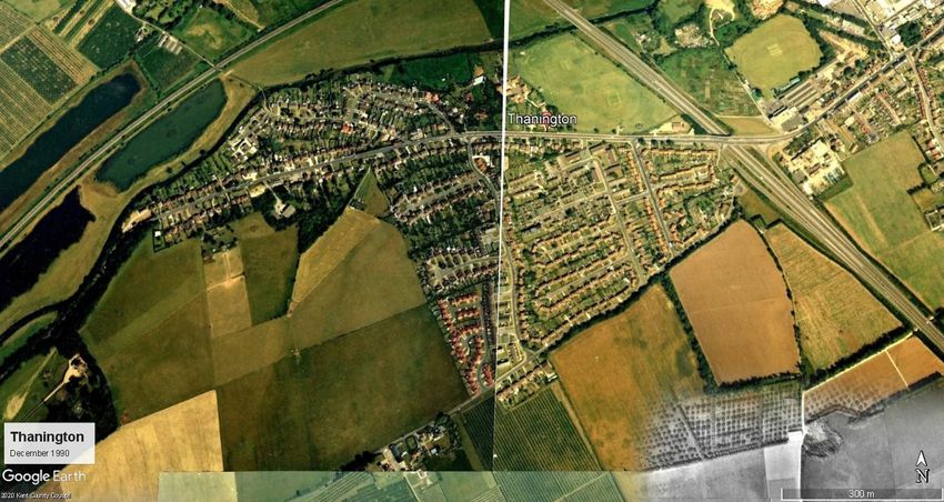
Thanington is an historic/ancient settlement significantly developed in the last 50years and is set to double the area
developed in the next 10years.
1.7 The intention of the Neighbourhood Plan is to influence the operation of the statutory local
planning framework, to provide a context for any new development, based on the local environ-
ment, local wishes and its continued sense of open space. The TNP is written with the input of
local opinion and knowledge and its use is intended to help these inputs guide area planning de-
cisions and details.
10Thanington Neighbourhood Plan 2020
Objective A. Support Local Associations
A1—Thanington Resource Centre
A2 - Ashford Road Community Association
A3—Hilltop Community Association (Canterbury)
11Thanington Neighbourhood Plan 2020
OBJECTIVE B: CONSERVE THE NATURAL AND HISTORICAL ENVIROMENT:
B1: Intention B2: Landscape and Biodiversity B3: Visual Impact
B4: Light and Noise pollution B5: Allotments B6: Climate Change
B7 Public Bridle and Right of way
B1: Intention
The intention of the Neighbour plan is to influence the operation of the statutory local planning frame work, to pro-
vide a context for any new development, based on the local character, environment and its sense of open space.
Objective of this section:
Describe the distinctive character of the area
Identify the environmental and historical feature of the area
To work in partnership with the local planning authority in the context of the existing local plan and to influence fu-
ture policies and developments.
Thanington has a mixed variety of environmental make up throughout the Parish. Ranged between urban and rural
designated areas.
Thanington Parish history details can be found in the appendix. It has a number of Historical and Environmental sites
within its boundaries. Larky Valley Woods is a designated SSSI. There are also a number of listed buildings and arche-
ologically sites.
1. Barn at Tonford Manor
2. Chapel of St John the Baptist Mil-
ton
3. Church of St Nicholas
4. New House Farmhouse
5. Old Manor
6. Thanington Court Farmhouse
7. Tonford Manor
8. Barn at Milton Manor
B2: Landscape and Biodiversity
The current CDLP policies that cover this topic are:
LB9: All developments to avoid a net loss of biodiversity and pursue opportunities to achieve a net gain
LB8: Ecological Improvements to be incorporated into new developments to improve connectivity
OS1: Proposals to protect and enhance sites designated as Local Green Space
OS9: Protected open space to be safe guarded unless specific criteria met
OS15: Permission is only be granted for the loss of allotments/community garden if criteria are met
OS5: Stuppington Lane green gap
OS11 Outdoor space provision
OS6: Green Gaps
12Thanington Neighbourhood Plan 2020
3.1: Thanington has many areas of natural and semi natural green space, and woodlands, Larky
Valley Woods SSSI. Green corridors as with footpaths, cycleway, bridleways and riverside
providing a crucial links to and from biodiversity sites. Thanington recreation field with its out-
door sport facilities, a play park and skateboard areas. Allotments, and cemetery. There is a re-
quirement from the community to maintain the level of green space available and this is partic-
ularly important in the urban-rural areas of the parish. This prevents an erosion of the charac-
teristic, due to unmitigated development
3.2:open spaces provide a whole range of environmental and recreational benefits to the com-
munity. It is important to maintain, protect and in some cases enhance. Where by environ-
mental and recreational assets meets the needs of the communities and positively influence
the physical mental and social well-being.
3.3: The impact of any development on ecological factors should be thoroughly analysed prefer-
ably independently. National agency opinions should be considered and also local opinion. On-
ly those developments that can prove true sustainability in this area will be supported.
3.4:Chapter 11.11 of CDLP recognize the importance of protecting our open space for its eco-
logical amenity and educational benefits. TNP will not support any development which fright-
ens the loss of green space which will have a detrimental effect on the environmental and
health and social wellbeing.
3.5: Consideration will be given to new development which make appropriate provision for
open door space which must include the following: semi-natural areas, green corridors, strate-
gic urban parks, children play parks and open space for recreation amenity, and allotments.
3:6: Thanington recognise the importance of the green gap policy, and would aim to adopt such
policy to maintaining the open space around the area. This is especially
Critical for the North and South Ward (Larkey Valley woods area, New House Lane and Iffin
Lane) where by any new development will erode the rural disposition effecting the character of
the open countryside.
3.7: TNP will not support any new development which pose a risk of coalescence of existing
settlements, i.e. Thanington South Ward towards Stuppington, and Thanington North Ward to-
wards Chartham. This is especially importance to over developed urban areas. In which Than-
ington has been granted two more large developments.
3.8:TNP will support the green infrastructure a council open space strategy a network of green
spaces. Thanington area includes field’s woodlands Hedgerows Rivers and lakes and urban are-
as includes gardens street trees sports pitches civic spaces and wall, facing challenges such as
climate change flood risk water management and food supply.
3.9: Thanington consists of areas dedicated for the land subsequently used for agricultural and
orchards. Open space adjoining existing settlements, Particle important for employment and
the supply food chain. This landscape valuable in maintaining the
13Thanington Neighbourhood Plan 2020
characteristic of Thanington, which divides the north and south ward. Further developments
posing a risk of coalescence between settlements.
This plan will seek to support the use of land establish for farming encouraging employment
and contriving to the health and wellbeing of the residents. The TNP will not support such de-
velopment which go against this strategic approach.
3.10: TNP objectives is to protect wildlife and it’s Biodiversity. It is important to recognise the
network of these dedicated sites but also outside. Grassland, shrub, hedgerows, green corri-
dors and road side vegetation. TNP will seek to protect these distinctive character of the land-
scape and will not support any new development which Poses risk or causes damage.
3.11: Thanington neighbourhood plan acknowledgement Larkey Valley Woods (SSSI) as a na-
tionally designated sites, (under section 28 of the wildlife and countryside act 1981). For it’s
abundant of wildlife and its habitats. The impact of developments through mitigation measures
should seek an avoidances though further appropriate survey by independent bodies by plan-
ning system.
3.12: Historical sites and the surrounding area must be protected when any development is
considered. Genuine consideration and long term vision must be a priority given to the proxim-
ity from any other future developments to these sites. This will be supported but opposed if it
is felt not to be the case.
Thanington Neighbourhood Plan would aim to propose a green gap policy to be included in the CDLP. Espe-
cially important for the urban and rural character of the area.
B3: VISUAL IMPACT
The current CDLP policies that cover this topic are:
LB2: Impact of the development on Areas of High Landscape Value
LB10: Development to the designed to retain important trees, hedgerows and woodland
OS12: Green infrastructure to be planned, designed and manage to conserve and enhance the character of
landscapes and settlement. Measures to be implemented for new major development sites HE13: Historic
landscapes, parks, and gardens to be preserved and enhances
HE13: Historic landscapes, parks, and gardens to be preserved and enhances
4.1: Genuine
consideration should be given to the visual impacts of major and even small devel-
opments on the local area. The views of the local people should be considered and also any
independent agency.
4.2: The planning for mitigation on visual impact must be considered and given priority when
setting out any planning acceptance requirement.
4.3:The long term visual impact and enhancement of any visual impacts must be part of the
planning design and support will be given if this is to be proven the case.
14Thanington Neighbourhood Plan 2020
4.4:Particularly attention given of the impact on landmarks, ancient monuments and long views
towards Canterbury cathedral. Views of the river Stour, Chartham, Biggate and southwards to
the Pethham Valley.
An outset detailed design plan is needed to show support, enhancement and protection for Historic
Landscapes, parks and gardens.
B4: LIGHT AND NOISE POLLUTION
The current local plan policies that cover this topic are:
DBE9: Outdoor lighting proposals, criteria for assessment
QL12: Mitigation of pollution from new development
APPX5: Outdoor lighting.
5.1: Thanington with its variety of area, both rural and urban has different requirements in terms
of consideration towards light pollution. Consideration will be given when a detail plan outlining
the avoidance of negative impact on these area.
5.2: Support will be given to development plans if light pollution criteria is met and does not have
a detrimental effect on the resident’s wellbeing, whereby not compromise the safety aspects.
5.3: TNP will look to support any development who actively mitigate the impact resulting in noise
from new developments on the local resident’s health and the quality of life.
5.4: TNP will look to support any developments with an outline detailed plan that minimise the
effects of pollutant from any new development.
TNP would seek a detail plan of criteria for assessment on avoidance of negative impact and
mitigation of pollution and lighting in residential areas and other valuable land including
SSSI.
B5: AL- LOTMENTS
The current local plan policies that cover this topic are
OS15: Permission to only granted for loss of allotments/community gardens
if criteria are met
QL4: Support for farm shops in appropriate locations
6.1:Local allotments and community gardens must be considered to provide or enhanced. Re-
moval of existing facilities will not be supported unless to enhance and/or prevision are met in
the new development plan.
6.2:TNP will look to support new Farm shops with a view to sell local produce. This in fact will
help to mitigate the impact of pollutant on the ideas area.
15Thanington Neighbourhood Plan 2020
Support will be given to any development which show consideration for a well proportion and ade-
quate facilities
B6 CLIMATE CHANGE
The current local plan policies that cover this topic are
CC1 Proposals for renewable and low carbon sources of energy to be encouraged in appropriate locations .Removal of
installations required after use has ceased
CC2 Development to include measures to reduce carbon emissions from energy use
CC3 Strategic sites and large developments to provide site wide renewable or gas fired combined heat and power un-
less specific criteria met
CC4 Development proposals within areas of high risk of flooding or increased surface water run- off to be subject to a
FRA
CC5 New development permitted on undeveloped sites within flood zones 2 and 3 only where sequential/exception
tests passed
CC6 Minor infill development on previously developed land in Flood zones 2 and 3 acceptable subject to other plan
policies.
CC7 No development within overtopping hazard zones
CC11 Sustainable drainage systems to be utilised. Greenfield run- rates to be achieved where possible. Hierarchy for the
management of surface water flows. Details of f management of SUDS to be provided prior to commencement.
CC12 Water quality to be safeguarded and enhanced where possible as part of new development proposals
CC13 Development to be phased to ensure the provision of necessary water infrastructure works. Development to min-
imise water use and incorporate water efficiency and recycling measures.
B7
7.1 TNP supports the current CDLP outlined in chapter 7 of the CDLP currently adopted. due to
concerns of the climate change, TNP would encourage CDLP to continue to work and strengthen
this section. This has become more apparent with two new developments in the area.
7.2 The first area of concern is the prevention of flood risk along the River Stour. Development
within any designated flood zone along the river will only be permitted with suitable mitigation
measures enforced as recommended by the respective agencies, i.e. K.C.C., The Environment
Agency or any other responsible agency with expertise and authority. No building on these iden-
tified flood zones should be considered. The land north of the River Stour is identified as High
Risk Flooding.
7.3 TNP would like to address it’s concerned with air quality particularly along the A28.
Any new
development must take notices the possible concerned of the local residents. Consideration must
be focused as a whole and not just the immediate impact of the developments within the area.
16Thanington Neighbourhood Plan 2020
7.4 TNP would seek to support developments which show designs for carbon neutral homes, fea-
tures that includes modern energy and environmental conservation technologies. To offset the
carbon emissions. The existing CDLP includes water recycling, recovery system and solar energy
systems. Policy CC1 &CC2 need to be strengthened in this area.
7.5 All new sites should be thoroughly assessed to ensure that existing water and sewer services
are adequately supported for any new development. To identify and mitigation of services and
measure to overcome this.
TNP will encourage the CLDP to include their own detailed air quality assessment report to continue
to monitor the area of local concern, by an independent professional body, and not affiliated to any
other person or group, before, during and after any new development.
B8: PUBLIC BRIDLE AND RIGHT OF WAY
Policy which CDLP supports this document is T2 pedestrian and cycle
routes
8.1: Thanington has many green corridors these include public footpaths, bridleways and cy-
cleway used by many as a direct link to other areas in the parish. Providing valuable space for
walkers and other recreation activities. Which are a crucial link to and from other biodiversity
sites.
8.2 To reduce the need for vehicles, the parish would like to see a network of footways linked to
the surrounding area and accessible to all.
8.3 Support will be given to developments which provide and enhance the existing walkways link-
17Thanington Neighbourhood Plan 2020
age to the new ones.
8.4: It is crucial that these new footways are well lit and maintained to ensure the safety and
wellbeing of the public.
8.5: These green corridors will need to be linear with natural vegetation and native hedgerow to
support
TNP will not support any new development which harms these crucial footways, its existing
vegetation and shows no designs for linkage of exiting public footpaths and cycleway.
the wild
flora fau-
na, a cru-
cial link to other biodiversity sites.
18Thanington Neighbourhood Plan 2020
OBJECTIVE C : SUSTAINABLE TRANSPORT ( 21/02/21)
CONTENT
C.1 Background
C2 Relevant LDP Policies
C.3 Bus Services
C.4 Cycle Network
C.5 Stour footpath
C.6. Parking and Traffic
C1 BACKGROUND
Traffic congestion and safety is a major consideration for the Parish. Thanington Parish comprises a mixture of rural
lanes, suburban estate roads and major trunk roads. The traffic situation has wide impacts on all aspects of Parish
life.
The main concern is the impact of the Traffic congestion on AIR POLLUTION and AIR QUALITY levels in Thanington.
This is particularly a concern on the A28 between HOWFIELD ROUNDABOUT & the A2/A28 junction leading into
Wincheap
The Parish has 2 major developments in early progress, that will have significant negative impact on the traffic situa-
tion in the Parish, SAXON FIELDS 750 dwellings (Pentland Homes)& COCKERING FARM 400 dwellings (Redrow).
From volume, congestion, air quality and the impact on rural roads.
The major road in the Parish is the A28 linking Ashford and Canterbury. It has major road intersections, which influ-
ence the traffic network, particularly the A2/A28 junction.
The rural roads in the parish comprise mainly of country lanes linking to both the city of Canterbury and major trunk
roads. Some of these lanes have small residential development as part of their makeup, others are uninhabited
country lanes, some being single track.
This makeup requires careful consideration of the resulting diverse issues to ensure that the total structure and lay-
out of the Parish and impact on these disparate areas is taken into account.
The existing mismatch of traffic density and capacity already causes issues, both on the major routes and the rural
lanes within the Parish. In part due to traffic trying to find alternative routes, to, through, and round Canterbury.
There are significant concerns regarding the impact of traffic from the current developments at Saxon Fields and
Cockering Road, particularly for St Nicolas Road, Strangers Lane and Cockering Road Also of concern, is the impact
19Thanington Neighbourhood Plan 2020
the nearby Mountfield Park development, will have on the traffic patterns and flows within and around the Parish.
The fourth slip road from the A2 to the A28 which is currently planned, should also consider in its design, the ergo-
nomics and operation of the proposed associated road network in a wider sense rather than just the local details.
There is concern that the current situation of traffic on the A28, particularly at peak times, will be a major traffic is-
sue unless this is considered and planned successfully. The photos below illustrate the current situation, which is
PRE the developments planned at SAXON FIELDS & COCKERING FARM.
Congested Traffic on A28 at HOWFIELD ROUNDABOUT
Congested Traffic on A28 Between HOWFIELD LANE & HOWFIELD ROUNDABOUT
20Thanington Neighbourhood Plan 2020
T1 Location of new developments to be considered against Canterbury Transport Strategy
T2 Proposed pedestrian and cycle routes to be protected
T3 Bus Improvement Links. Permission not to be granted for proposals that prejudice bus improvement measures
and fast bus links
T5 Wincheap Park & Ride . Land safeguarded for expansion
T9 Parking and cycle provision to have regard for identified standards
T11 Wincheap Traffic Management Scheme . Implementation of the A2 OFF –SLIP road at Wincheap , an A28 relief
road and improvements at Wincheap Green . Proposals which prejudice these routes will be resisted
T16 Rural lanes of landscape amenity ,nature conservation ,historic or archaeological importance protected from
changes
T17 Transport Assessment and Travel Plans required for developments which would have significant transport im-
plications
C2 RELEVANT LDP POLICIES
C3 BUS SERVICES
T3: BUS IMPROVEMENT LINKS : Permission not to be granted for proposals that prejudice bus improvement
measures and fast bus links
T5: WINCHEAP PARK & RIDE. Land safeguarded for expansion
The current Local Plan Policies that cover this topic are:
The bus links to the area generally poor in both rural and suburban areas of the Parish, with very limited areas hav-
ing close links to a regular bus service.
There is a need to develop sustainable bus services to both the Urban and Rural sections of the Parish and these pro-
21Thanington Neighbourhood Plan 2020
posals would be supported. There is a need to ensure that they will link to the major hubs in the city, i.e. East & West
Stations and also the Bus station. That will allow onward transport to further afield destinations. Consideration and
investigation of the use and requirement for public transport should be taken into account for future requirements,
more than is the current case.
The impact on fast bus service times, caused by any development impact on the traffic flow, must be taken into ac-
count when considering any developments, and their traffic flow impact on the existing infrastructure.
PROJECT C3.1
Bus routes should be consulted on regarding route and service levels with the local community by the service
provider, developer and the Local authority.
Thus Supporting those areas that do not have a bus service of any kind, and are inaccessible to existing services
RELEVANT POLICY T3.
The existing Wincheap Park & Ride is not fully utilised, and development of this service to encourage more sustaina-
ble use would also be supported. The further development of the P&R site should consider all aspects of its impact,
PROJECT C3.2
Routes and service levels should take into account demand and travel destinations particularly at peak times.
This should be consulted on with the local community and also surveyed as regards actual demand and destina-
tions to maximise the effectiveness of the public transport provided.
RELEVANT POLICY T3.
environmental, access and egress.
PROJECT C3.3.
The Wincheap Park and Ride should be surveyed, to ensure that it can be utilised to the best levels. This should
involve local consultation and consultation with users to find out what could be done to improve its effectiveness,
and utilisation.
RELEVANT POLICY T5.
C4 LOCAL CYCLE NETWORK
The current Local Plan Policies that cover this topic are:
T2 : Proposed pedestrian and cycle routes to be protected
OS8: Sports and recreation in the countryside, criteria for assessment
QL2: Improvements to village services and facilities to be approved, unless there are overriding conflicts
22Thanington Neighbourhood Plan 2020
The only cycle path in the Parish is the Stour valley path. This is used by both the local and non-local population. It is
a well thought of asset and its support and maintenance should be supported.
The local lanes in the rural area of the Parish are used by various cycle groups, and means of using these, and main-
taining a safe use for cycling should be supported.
Photograph of Stour Valley Cycle Path
There is no direct route, for both the cycling or walking, into Canterbury, from the Parish, particularly along the A28
corridor. The A28/A2 junction at Wincheap, being a particular block to safe easy access. There is a need to address
this.
Proposals to modify this and other areas along the walking cycling routes, or new routes, should be impact on
traffic and vehicle movements, particularly during the school run periods. It would also allow safer access for walking
and cycling outside of these peak periods which again would have an impact on traffic flow and congestion.
PROJECT C4.1
The proposed Wincheap relief road to incorporate cycle route provision
RELEVANT POLICY T2
PROJECT C4.2
Any development should include adequate upgrades or inclusion for cycling and walking improvements .
Not just in the local environs of the development, but also further afield to ensure practical improvements
for sustainable modal shift.
RELEVANT POLICY T2
23Thanington Neighbourhood Plan 2020
PROJECT C4.3
Incorporate improvements to both existing and new PROW that encourage and improve access for cycling
and walking. Recent events have shown that increased walking and cycling activity can have damaging
effects on the environment around these PROW if the surface is not adequate and the use level high. That
would indicate that the surface could need upgrading and should be considered
RELEVANT POLICY T2
C5 STOUR FOOTPATH
OS13 Land identified along the River Stour corridors protected from development. Regard to be had to the to
the Riverside Strategy
LB13 The environment within river corridors will be conserved and enhanced . Supply of water , treatment
and disposal of waste water and flood risk management should be sustainable.
The current Local Plan Policies that cover this topic are:
Photograph Stour Valley in Thanington
The land along the Stour corridor needs to be protected and maintained because of its importance to the environ-
ment and protection of Canterbury and its environs.
24Thanington Neighbourhood Plan 2020
The use of this area for transport will not be supported except if it encourages or enhances the features for either
cycling or walking. Consideration on any development in this area should take into account the conflict between
these activities, and ensure that both can occur safely, and not detrimentally impact the other.
The path along the Stour corridor is an important asset to the Parish and if enhanced to encourage more use could
have a positive effect on traffic. Any proposals to assist this and also assist access and usability in a controlled way
should be supported.
INSERT EXAMPLES AND COMMENTS AS APPROPRIATE AFTER FURTHER CONSULTATION
Initial suggestions?
C6 PARKING & TRAFFIC
T16 Rural lanes of landscape amenity, nature conservation , historical or archaeological importance protected from
changes which would damage their character and where possible enhanced
T17 Transport Assessments and travel plans required for developments which would have significant transport im-
plications
HE7 Highway works and traffic schemes to protect the character and appearance of historic buildings and conserva-
tion areas.
QL2 Improvements in village services and facilities to be approved unless there are overriding conflicts
QL11 Mitigation of pollution from new development.
The current Local Plan Policies that cover this topic are:
Traffic on A28 approaching Strangers Lane & St Nicolas Road
25Thanington Neighbourhood Plan 2020
The parish has some obvious problems with both traffic and pollution relating to traffic movements and volumes.
These are specifically firstly along the A28 corridor from the Howfield roundabout to the Wincheap roundabout. At
peak times, and sometimes at non peak times, traffic can queue in both directions . The rural lanes in the Parish have
seen a significant increase in traffic flow at both peak and non-peak times. These being single track lanes in many
instances, leads to a safety problem, and also damage to the road surface, road edges, road surrounding hedges and
banks. Both of these issues have increased significantly in the last 24 months. The main cause being congestion on
the main routes. There is concern that the existing developments planned in the area have not taken sufficient or
accurate consideration of their impact on traffic, or the traffic impact on environmental issues particularly pollution.
There are particular concerns about traffic from the Pentland / Redrow developments relying on access/egress via
Cockering Road, Strangers Lane and St Nicolas Road these are primarily residential estate roads and unsuitable for
this scale of development. New development must take into account its affect in this area. This has not happened in
the recent proposals, the emphasis being on the Traffic assessments supplied by the developer. Some of these have
been found incorrect retrospectively, after grant of planning permission. There have also been concerns expressed
regarding the mitigation measures proposed to deal with these issues. Yet again these have been found wanting ret-
rospectively.
This should be corrected by more consideration given to auditing independently, what is submitted in Developer’s
Traffic Assessments TA’S, and also more consideration given to local residents concerns and knowledge, by the local
Planning authority.
Insert Photographs when available of traffic in St Nicholas Rd &Strangers Lane
The existing major road network has been found to be at capacity at particularly peak times. Concern is that this is
occurring before any of the major developments in the Parish are operational. The mitigation measures already put
in place i.e. the traffic lights at St Nicholas Road exit onto the A28, have already been found to be causing increased
delays to accessing the A28. Which is understandable, when one looks at the traffic congestion, already existing on
the A28 at this point. There is also concern expressed about the A28/A2 junction layout and traffic light operation.
This has been accepted by the local planning authority, but with the current congestion levels there is evidence to
suggest that there is a problem with what is proposed.
- The existing traffic situation dictates that any mitigation measures must be confirmed to be adequate and effective
in their delivery. Such measures should be installed in sufficient time to ensure the problem being dealt with, does
not become excessive, and cause even more major disruption if carried out later. These proposals would be support-
ed.
Car parking is a problem in the suburban developed areas of the Parish. This has been exacerbated by the reduction
in car parking facilities in the main city. This has led to daytime on-street parking having increased, even in the area
of the Park and Ride i.e. Homersham as an example.
Insert Photographs when available of parking in Homersham
There is concern that new developments in our area do not have adequate residential, and on street parking allow-
ance. New developments small or large must have adequate parking allocation and sufficient space to enable safe
unhindered access for all emergency and service vehicles at all times. Whilst the aim for a modal shift to walking and
cycling is admirable realistically in inclement weather residents will default to using their cars.
Adequate parking and measures to ensure safe and adequate access for emergency and service vehicles at all times
would be supported.
When considering large scale or medium scale developments adequate consideration must be given to site access
routes and ensure these are fit for purpose and in place prior to work commencing. The example being the Saxon
Field development, where there is concern local estate roads and residents, are being subjected to unacceptable
26Thanington Neighbourhood Plan 2020
disruption for a prolonged and extended period. Only proposals to ensuring this is done adequately will be support-
ed.
To ensure that new development does not impact on environmental pollution, Iindependent data should be consid-
ered when analysing any proposed developments. The practice of using developer sponsored data does not give the
most balanced view. The extensive use of electric vehicles may reduce the air pollution problem but they are in all
probability, a long way off being fully available both economically and also from a charging supply point of view. This
must be taken into account. Whilst replacing petrol/diesel with electric vehicles will help improve local air pollution
PROJECT C6.1
Development that reduces the existing ON SITE car parking should be audited .The effect on ON STREET car
parking, if this is, are is not, allowed, should be taken into account when considering these developments and
this parking affect mitigated for. Electric vehicles or other vehicles using green technology require parking and
are likely to remain a requirement for the foreseeable future and car parking must be given sufficient consider-
ation.
RELEVANT POLICY T17,T9
it will NOT impact the volume of traffic and its associated congestion.
PROJECT C6.2
20mph speed restrictions should be considered in Cul de Sacs or other areas, due to safety and parking limita-
tions.
RELEVANT POLICY T17
PROJECT C6.3
20mph speed restrictions should be considered in Cul de Sacs or other areas, due to safety and parking limita-
tions.
RELEVANT POLICY T17
PROJECT C6.4
Development on existing properties, as well as new, should include for the provision of at least one electrical vehi-
cle chargeg point.
RELEVANT POLICY T17 QL
PROJECT C6.5
Consideration should be given to limiting access, or design access modifications, to some rural lanes etc to pre-
vent RAT RUNS developing. This is particularly relevant were there are sites of environmental interest or safety
issues due to the size of the roads concerned.
RELEVANT POLICY T17 T16
27Thanington Neighbourhood Plan 2020
PROJECT C6.6
Consideration should be given to limiting access, or design access modifications, to some rural lanes etc to prevent
RAT RUNS developing. This is particularly relevant were there are sites of environmental interest or safety issues
due to the size of the roads concerned.
RELEVANT POLICY T17 T16
PROJECT C6.7
Speed restrictions should be considered on some of the Parish’s rural roads which are becoming increasingly used
and increasingly dangerous to use for walking and cycling. If this is not done then encouraging cycling and walking
becomes difficult t promote
RELEVANT POLICY T17 T16
PROJECT C6.8
Major new development should have sufficient provision for adequate car parking both ON SITE & ON ROAD . The
existing developments in the parish are lacking in this and this should be addressed in detail when consideration is
given to any application.
RELEVANT POLICY T17
PROJECT C6.9
Yellow lines should be considered if there is the potential problems with service and emergency vehicles
RELEVANT POLICY T17
28Thanington Neighbourhood Plan 2020
Objective D. Community
C1—Development to Hilltop Design Statement
C2—Drainage, Sewage and Flood Hazard
C3—Infilling in gardens
C4—Air Quality
C5—Impacts on Biodiversity
C6—Archaeological assesment
29Thanington Neighbourhood Plan 2020
Objective E. Promoting Healthy Communities
D1—Community services and facilities
D2—Green Infrastructure
30Thanington Neighbourhood Plan 2020
Objective E. Quality of Life
E1—North Ward Estate
E2—20 MPH speed limit on roads
E3—River Stour
E4 Fishing Lakes
E5—Larkey Valley Wood
31Thanington Neighbourhood Plan 2020
Thanington has many historical features and two areas of ancient natural woodland. Larkey Valley wood is a Site of
Special Scientific Interest noted for its orchids, woodland plants and dormice. It is owned and managed by the Can-
terbury City Council for nature conservation and public access.
Iffin and Hand woods are privately owns however they are managed for pheasant shooting and contain a Bronze Age
tumulus with a mediaeval manor and chapel. Theses site link together with a corridors of hedges which provide
abundant of life for many species of wildlife.
St Nicolas Church Thanington
Bigbury camp: This site is a scheduled Ancient Monument and is an Iron Age hill fort in the east Kent. It is managed
by the Kent Wildlife trust. Its located 2.0mi west of Canterbury and situated on a minor road between A2 and A28
32Thanington Neighbourhood Plan 2020
Objective F. Conserving and Enhancing the Natural Environment.
OBJECTIVE F: CONSERVING AND ENHANCING THE NATURAL ENVIRONMENT
(DRAFT 28/01/21)
PURPOSE: The intention of the Neighbour plan is to influence the operation of the statutory local planning frame
work, to provide a context for any new development, based on the local character, environment and its sense of
open space.
Objective of this section:
1. To describe the distinctive character of the area
2. To identify the environmental and historical feature of the area
To work in partnership with the local planning authority in the context of the existing local plan and to influence fu-
ture policies and developments.
F: BACKGROUND
Hilltop area of Thanington
Thanington Parish is a civil parish and inner suburb of Canterbury. It extends to the south –west of A2 from
Wincheap out towards Milton Bridge Chartham. It is the only parish area within the city of Canterbury. The north
ward of Thanington follows the river Stour. North of Ashford road has housing and south of Ashford road has a large
estate of mixed housing. South ward of Thanington linear settlement along New House Lane, New House Close, Iffin
Lane. The parish church is dedicated to St Nicholas and is located on Thanington road. Thanington Without changed
to Thanington on 1st April 2019.
Ashford Road Thanington
33Thanington Neighbourhood Plan 2020
roads.
Cockering Manor/farm is a listed building and is situated in Cockering road towards Larkey Valley woods on trunk
rural road, surrounded by agricultural land, on the same road leading towards the village of Chartham, documented
back to 1235.
Howfield Manor near Milton church is a historic house, the original portion now kitchen and breakfast rooms is be-
lieved to date back to 1181. Its situated on the A28 towards Ashford near Milton church. It is now a private hotel.
Milton Manor situated on the A28 Ashford road is mention as far back as the doomsday book. Houses two water
mills hence the name Milton. Once belonged to De Crevequer who long been Sheriff of Kent. The site today is a
gravel extraction. Several lakes have been left in the water meadows attracting many wildlife.
Milton church a small 12th century church located on the site which is now redundant.
New House Farm situated half mile from south of Canterbury. Earliest dates are found from 1270 to 1278, it has had
many different owners. Residence Captain Terry to George Gipps M.P who also owned many property in the area.
In December 1949 farm workers discovered a Romano Britain flint swallow pit containing many pottery dating back
to A.D 80-100, items found were a one handed jug, an urn containing a human bone (unfortunately smashed by a
plough) and a simian platter bearing the potter’s stamp, these items are with the Royal museum Canterbury.
Thanington Court
Mention in the Canterbury Doomsday Book and recorded as land once owned by Godefridus and Dapifer, in the
reign of William l. Norman families of Valynes and George Gipps M.P who owned New House Farm were once resi-
dents.
Tonford Manor
Situated to the north side of the River Stour this half ruined flint, brick walls, flanking towers, timbered roof and a
carved corbels of the 15th century, a Tudor gateway. Records show dwellings on this site date back to the Henry lll.
The house today is half 15th century and half Queen Ann. King Henry the VIII and Queen Kathrine of Aragon paid a
visit and stayed for three nights. Later a well-known writer Christopher Hassall who died in 1963 was a resident and
34Thanington Neighbourhood Plan 2020
had a local road name after him.
River Stour
River Stour Thanington
This river has played a very important part throughout history. From the first settlers to the Iron Age at fort Bigbury
overlooking the valley and ford at Tonford. Most local names are derived from Anglo Saxon however river names
are older, Celtic for water. The Stour is Kent’s second longest river which flows through Milton and Thanington for
several miles. It’s famous for trout fishing and boating, and has much abundant of wildlife. It had also worked mills
and properly a mill at Milton Manor in the middle ages or earlier. Once the river flow near to Howfield Manor how-
ever during the Napoleonic wars this was changed when a new road was made alongside the river. The land at Ton-
ford was used by farmers until recently and the area was favoured by the painter Sydney Cooper R. A. Today it is
looked after by the environment agency and supported by many partnerships with many projects to enhances and
protect the river.
Landscape
The hilltop area is surrounded by agricultural land on all sides arable and or market gardening crops for grazing of
livestock. It is important to say the view of Canterbury cathedral can be seen. Hedgerows or wooded areas contain-
ing native vegetation types line new house lane, lffin lane Merton lane and the bridle paths. This area is well served
by a network of public footpaths that link to Larkey valley woods, Wincheap via Hollow lane and Stuppington lane
and also to hand and lffin woods.
Between hilltop area and cockering road, here is a vast area off agricultural land, a footpath connects the two area
together. Today Saxon field is an ongoing development consisting of up to 750 homes including commercial, the pub-
lic sector and recreation.
Manor Close is a small cul-de-sac and the last of homes before you reach Larkey Valley woods on the same trunk
road to Chartham Village. On the west side of Larkey Valley woods here is an area of agriculture land which stretches
towards Milton Manor, this site has been approved to develop 450 homes.
On north sides Tonford manor here are expanded vast flood plains supporting wildlife and runs parallel with the river
Stour. On the west side towards Charham is a mixer of orchids and agricultural lands.
F1 IMPORTANT GREEN SPACES
35Thanington Neighbourhood Plan 2020
The current local Plan policies that cover this topic are:
HE13: Historic landscapes, parks, and gardens to be preserved and enhanced
LB2: Impact of the development on Areas of High Landscape Value
LB8: Ecological Improvements to be incorporated into new developments to improve connectivity
LB9: All developments to avoid a net loss of biodiversity and pursue opportunities to achieve a net gain
LB10: Development to be designed to retain important trees, hedgerows and woodland
LB13: The environment within river corridors will be conserved and enhanced. Supply of water treatment, and
disposal of waste water and flood risk management should be sustainable.
OS1: Proposals to protect and enhance sites designated as Local Green Space
OS9: Protected Open Space to be safe guarded unless specific criteria met
OS15: Permission to only be granted for loss of allotments /community gardens if criteria are met
There is a requirement from the community to maintain the level of green space available and this is particularly
important in the Urban areas of the Parish. This prevents an erosion of this characteristic, due to unmitigated devel-
opment. Thanington has a good level of green accessible space and this must be maintained or improved by devel-
opment.
Support will be given to those developments that seriously take this into account, and those that do not will be op-
posed.
The impact of any development on ecological factors should be thoroughly analysed preferably independently. Na-
tional agency opinions should be considered and also local opinion. Only those developments that can prove true
sustainability in this area will be supported.
Development planning should genuinely improve and include green space areas, and also community areas, and will
be supported if this is proved.
The impact of removing established areas of green space and associated surrounds, must be taken into account
when consideration of development. Replacement sometimes is not an improvement, or sustainable, over what was
original. This must be taken out into during considerations.
Historical sites must be protected and also their surroundings when any development is consideration. Also the im-
pact on them by any close development must be given genuine consideration and long term vision. This will be sup-
ported but opposed if it is felt not to be the case.
F2: VISUAL IMPACTS
The current local Plan policies that cover this topic are:
HE13: Historic landscapes, parks, and gardens to be preserved and enhanced
LB2: Impact of the development on Areas of High Landscape Value
LB10: Development to be designed to retain important trees, hedgerows and woodland
LB13: The environment within river corridors will be conserved and enhanced. Supply of water
treatment, and disposal of waste water and flood risk management should be sustainable.
OS12: Green infrastructure to be planned, designed and managed to conserve and enhance the character of land-
scapes and settlements. Measures to be implemented for new major development sites
Genuine consideration should be given to the visual impacts of major and even small developments on the local
36You can also read