Road Safety Plan Erie Regional Planning Commission - April 2020 - City of Huron
←
→
Page content transcription
If your browser does not render page correctly, please read the page content below

Erie Regional Planning Commission
     Road Safety Plan

            April 2020
TABLE OF CONTENTS:

TABLE OF CONTENTS: ..............................................................................................................1
1 EXECUTIVE SUMMARY..........................................................................................................2
2 TRANSPORTATION SAFETY PARTNERS ............................................................................4
3 INTRODUCTION – SETTING THE STAGE .............................................................................6
   3.1 Transportation Safety Planning ............................................................................. 6
   3.2 Erie region Transportation Safety .......................................................................... 7
   3.3 Vision, Goal and Objectives.................................................................................. 9
4 EXISTING CONDITIONS – UNDERSTANDING SAFETY NEEDS IN THE ERIE REGION .11
   4.1 The Big Picture .............................................................................................. 11
   4.2 Crash Types .................................................................................................. 15
5 EMPHASIS AREAS ...............................................................................................................25
6 IMPLEMENTATION & ACTION PLAN – CREATING A SAFER SYSTEM ..........................47
   6.1 Priority Intersections........................................................................................ 53
   6.2 Priority Segments............................................................................................ 56
7 RECOMMENDED EARLY ACTION PROJECTS ....................................................................61

   1 ERPC Road Safety Plan

1 EXECUTIVE SUMMARY
ODOT recognizes the need to address fatal and serious injury crashes and is encouraging the development of
Regional Safety Plans to reduce them. The Erie Metropolitan Regional Planning Commission (ERPC) Road Safety
Plan provides a framework for identifying, analyzing and prioritizing road safety improvements. This plan provides
stakeholders with a prioritized list of high crash locations along with mitigating strategies and projects that will be
eligible for ODOT safety funding.

The area encompassed by the ERPC Metropolitan Planning Organization (MPO) planning area is located in north
central Ohio and home to approximately 75,000 residents who live within nine 9 municipalities within the 255 square
mile area. For the purpose of this study, the ERPC MPO planning area, which includes all of Erie County and the
Lorain County portion of the City of Vermillion, is referred to as the “Erie region”. The study area also includes Cedar
Point, the Lake Erie shoreline and islands, which are significant tourist destination. Although transit, bicycle, and
pedestrian infrastructure are modal options within the Erie region, motor vehicle travel is the most common travel
mode.

The study included a 9-year analysis period (2009 through 2017) based on available crash data. During that period,
2,401 transportation-related injury crashes were reported. Annual average data reflects 267 crashes with 9 fatalities,
99 serious injuries and 29 non-serious injuries. Motor vehicle crashes are often preventable. Crash mitigation requires
an understanding of crash locations, types and contributing factors to understand why crashes occur and to identify
strategies to reduce crashes and crash potential.

Erie Region Map (ERPC Planning Area)

   2 ERPC Road Safety Plan

The ERPC Road Safety Plan analyzed crash data to understand crash patterns, trends and contributing factors,
focusing on fatal and serious injury (FSI) crashes. The analysis results were used to identify mitigation strategies,
potential treatments and solutions to address the highest priority safety issues in the region based on crash frequency
and severity. Crash data were reviewed with stakeholders to understand:

    ·   Crash Trends – Trends in fatal and serious injury crashes over the past 9 years, including a review of
        crashes by jurisdiction and by roadway type

    ·   Crash Types – Types of crashes that are over-represented (i.e., rear end, roadway departure, etc.)

    ·   Crash Locations – Segments and intersections in the region that experience more crashes on average
        than other locations; these locations could be investigated further for safety improvements.

    ·   Contributing Factors – Types of crash contributors that are over-represented in the region (i.e., alcohol
        impairment, age, speed, etc.)

    ·   Safety Performance – Treatment(s) and extent of mitigation measures for fatal and serious injury crashes
        through the implementation of proven solutions for the identified crash types

Local transportation and safety stakeholders met twice to review the crash data and provide input into the foundation
of the plan. This plan analyzes crash data; it identifies mitigation measures, treatments and strategies; and it
recommends countermeasures to address the highest priority crash locations within the Erie region. Plan components
include:

    ·   The plan’s Vision, Goal and Objectives provide a framework for identifying safety programs, projects and
        policies.

    ·   Four emphasis areas, Intersections, Roadway Departures, Distracted Driving, and Speeding were
        identified as the most significant traffic safety-related challenges in the region.

    ·   The Action Plan identifies high priority intersection and corridor locations that, if mitigated, would make a
        significant impact on road safety in the region. The Action Plan outlines programmatic and project
        solutions, showing ERPC stakeholders where to focus their time and resources to make the most
        significant difference in improving road safety.

   3 ERPC Road Safety Plan
2 TRANSPORTATION SAFETY PARTNERS
Development of this plan is intended to help stakeholders within the Erie region to understand crash patterns
associated with fatal and serious injury crashes, and identify projects, programs and policies to improve transportation
safety by mitigating crashes and contributing factors that result in fatalities and serious injuries. The Erie region
includes a wide range of transportation and safety stakeholders who are working to reduce fatalities and serious
injuries resulting from motor vehicle crashes. Numerous stakeholders were invited to participate in the plan
development process. The organizations, agencies and jurisdictions listed below actively participated;
representatives came together on two occasions to review crash data and analysis results to provide local perspective
which informed the contents of this plan. This group intends to maintain ongoing coordination to implement the safety
solutions and strategies identified in this plan to mitigate transportation-related fatal and serious injury crashes.

    ·   Erie Regional Planning Commission (ERPC)                      ·    Ohio Department of Transportation, District 3
    ·   Erie County Engineer’s Office                                 ·    Ohio State Highway Patrol
    ·   Erie County Sheriff’s Office                                  ·    Ohio Turnpike and Infrastructure
    ·   City of Huron                                                      Commission
    ·   City of Sandusky                                              ·    North Central EMS
    ·   City of Vermilion                                             ·    Perkins Police Department
    ·   Edison Local Schools                                          ·    Perkins Township
    ·   Milan Township                                                ·    Vermilion Police Department
    ·   Village of Milan                                              ·    Sandusky Police Department
    ·   Ohio Department of Transportation, Central
        Office

Additional organizations were invited to the workshops and solicited for feedback on the action plan:

    ·   Board of Erie County Commissioners                        ·       Erie Soil & Water
    ·   City of Sandusky Community Development                    ·       Federal Highway Administration
    ·   Erie County Department of Environmental                   ·       Huron Local Schools
        Services                                                  ·       Margaretta Township
    ·   Erie County Economic Development                          ·       Milan Police Department
        Corporation                                               ·       Ohio Department of Public Service
    ·   Erie County Health Department                             ·       Sandusky City Schools
    ·   Erie County Safe Communities                              ·       Sandusky Transit Administrator
    ·   Erie Metroparks                                           ·       Serving Our Seniors

   4 ERPC Road Safety Plan
INTRODUCTION
   Setting the Stage

   SECTION CONTENT:
          Transportation Safety Planning

          ERPC Road Safety

          Vision Goals & Objectives

5 ERPC Road Safety Plan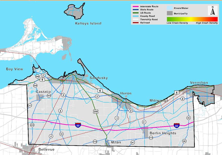
Introduction
Setting the Stage

3 INTRODUCTION – SETTING THE STAGE
3.1 TRANSPORTATION SAFETY PLANNING
The State of Ohio experiences an average of 1,000 transportation-
related fatalities every year. A national strategy called Toward Zero
Deaths concludes that even if it is unclear when fatalities will reach
zero, even one death on the transportation network is unacceptable;
this strategy is driven and supported by transportation, enforcement,        A SOLUTION – ROAD SAFETY PLAN
local government, educators, health professionals and emergency
response agencies. The Ohio Department of Transportation (ODOT)              ODOT recognizes the need to address
                                                                             fatal and serious injury crashes and is
has adopted the Toward Zero Deaths strategy and is working toward
                                                                             encouraging the development of
solutions to ensure safety on Ohio’s transportation network.
                                                                             Regional Safety Plans to reduce them.

One effective means to achieve this vision is development of local road      The ERPC Road Safety Plan provides a
safety plans (LRSP). This type of plan empowers local and regional           framework for identifying, analyzing and
transportation agencies to organize stakeholders; review crash data to       prioritizing road safety improvements.
understand the unique safety challenges in their areas; and identify and     This plan provides stakeholders with a
implement customized solutions and countermeasures that will be              prioritized list of high crash locations
effective based on the local context.                                        along with mitigating strategies and
                                                                             projects that will be eligible for ODOT
The ERPC Road Safety Plan followed a similar approach to develop             safety funding.
multi-disciplinary safety solutions. The planning process focused on the
understanding that, in most cases, motor vehicle-related crashes can be prevented. For example, improved roadway
features can limit crash severity and in others, stopping people from engaging in unsafe behaviors is key. However,
in most cases, it is a combination of both factors. Additional factors influencing potential for motor vehicle safety and
crash outcomes are improvements in vehicle smart technologies and safety equipment and improvements in medical
treatment. This plan identifies proven strategies, actions, programs and projects to reduce crashes related to
infrastructure and driver error, focusing on mitigating fatal and serious injury (FSI) crashes.

   6 ERPC Road Safety Plan
Introduction
Setting the Stage

3.2 ERIE REGION TRANSPORTATION SAFETY
THE STUDY AREA
The Erie region is located in north central Ohio, bordering the shores of Lake Erie, as illustrated in Figure 1. According
to the Ohio County Profile on Erie County which is researched and published by the Ohio Development Services
Agency, the estimated population of Erie County was 74,615 in 2018. This represents a decline from the official
population of 77,079 as recorded by the 2010 United States Census. Of the reported census population, 22 percent
was under the age of 18 and 18 percent was over the age of 65.

According to the Ohio County Profile for Erie County, less than 17 percent is developed and nearly 81 percent is
farmland or natural setting. Significant concentrations of population within the study area are Sandusky (population
24,714) Perkins Township (population 11,728) and Vermilion (population 10,437). The City of Vermillion lies within
both Erie and Lorain Counties (Population: 4,635 Erie Co., 5,903 Lorain Co.) Although the Erie region is mostly rural,
it includes the significant tourist destinations within and near the City of Sandusky, such as Cedar Point, lakefront
attractions, and other destinations which draw significant tourist traffic to the area.

Based on the Ohio County Profile for the Erie region, the Erie region includes approximately 870 miles of public
roadways. Nearly 158 miles are state and US routes, 267 miles are township roads, 140 miles are county roads, and
215 are municipal roads. The plan analyzed the entire network of public roads to understand crash patterns, including
the locations, severity, types and contributing factors for reported crashes in the Erie region.

EXTERNAL FACTORS IMPACTING CRASHES
This plan focuses on analysis of crash trends to understand the location and cause of reported crashes, particularly
fatal and serious injury crashes. Additional safety insights can be gained by understanding how other factors play a
role in transportation safety. Population and Vehicle Miles Traveled (VMT) trends were reviewed to better understand
the Erie region crash data.

Figure 1: Erie Region Map (ERPC MPO Planning Area)

   7 ERPC Road Safety Plan

Introduction
Setting the Stage

Population and Fatal and Serious Injury Crashes
Based on population estimates included in the Ohio County Profile, the overall population in the Erie region is
decreasing. As shown in Figures 2 and 3, fatal crashes are on a generally upward trend while serious injury crashes
are on a downward trend similar to the decreasing population.

Figure 2: Fatalities from Crashes and Population within the Erie Region, 2009–2017

                      14                                                                                                          77500

                      12                                                                                                          77000

                      10                                                                                                          76500

                                                                                                                                          Population Estimates
                      8                                                                                                           76000
   Fatalities

                      6                                                                                                           75500

                      4                                                                                                           75000

                      2                                                                                                           74500

                      0                                                                                                           74000
                            2009       2010        2011       2012     2013         2014            2015   2016        2017

                                      Fatalities          Population          Linear (Fatalities)          Linear (Population)

Figure 3: Serious Injuries from Crashes and Population within the Erie Region, 2009–2017

                      140                                                                                                         77500

                      120                                                                                                         77000

                      100                                                                                                         76500
                                                                                                                                          Population Estimates
   Serious Injuries

                      80                                                                                                          76000

                      60                                                                                                          75500

                      40                                                                                                          75000

                      20                                                                                                          74500

                       0                                                                                                          74000
                            2009        2010       2011       2012     2013         2014            2015   2016        2017

                               Serious Injuries           Population          Linear (Serious Injuries)           Linear (Population)

   8 ERPC Road Safety Plan
Introduction
  Setting the Stage

Vehicle Miles Traveled
Although the Erie region’s population provides a reasonable estimation of the concentration of people living in an
area, it does not fully capture vehicle travel patterns, which include visitors to the area as well as residents. This is
notable in the Erie region with its popular tourist destinations. Vehicle Miles Traveled (VMT) presents a clearer
indication of regional travel patterns. VMT reflects the number of vehicles traveling on identified roadways within a
specified year, independent of the ERPC population. VMT is calculated by multiplying the number of roadway
centerline miles by the Average Daily Traffic (ADT) volumes. Based on calculations provided by ODOT, VMT in the
Erie region demonstrates an upward trend during the analysis period.

Figure 4: Fatal Crashes and VMT within the Erie Region, 2009–2017

                                          Fatal Crashes and MVMT within Erie Co., 2009-2017
                        15                                                                                               15

                                                                                                                              Annual Milillion Vehicle Miles Traveled
                        12                                                                                               12
   # of Fatal Crashes

                                                                                                                                      (MVMT) in Erie Co.
                        9                                                                                                9

                        6                                                                                                6

                        3                                                                                                3

                        0                                                                                                0
                             2009         2010      2011      2012    2013        2014         2015   2016      2017

                                    Fatal Crashes          100 MVMT          Linear (Fatal Crashes)      Linear (100 MVMT)

CURRENT SAFETY ACTIVITIES
Existing safety programs and projects in the region were considered during the planning process. The plan is intended
to build upon, not replace, current activities by implementing additional proven strategies to reduce fatal and serious
injury crashes. The results of this analyses were reviewed and discussed during stakeholder meetings and
incorporated into the plan.

3.3 VISION, GOAL AND OBJECTIVES
The Erie region safety vision, goal and objective describe the safety aspirations for the next 25 years and what safety
success looks like in the near term, as reflected by the five-year planning horizon for this study. In developing the
specific vision, goals and objectives for this plan, stakeholders were presented with examples from ODOT and other
agencies as well as local crash data, showing historical safety performance and future forecasts. One of the main
objectives of the ERPC is to improve the safety of the existing transportation system through the study of traffic crash
data to identify safety improvements. ERPC supports ODOT’s statewide safety target of one percent annual reduction
across all five performance measures. The five safety performance measures established are 1) Number of fatalities,
2) Number of serious injuries, 3) Fatality rate, 4) Serious injury rate, and 5) Number of non-motorized fatalities and
serious injuries. The elements covered in following sections present a framework that will help the Erie region focus
funding and resources to implement safety policies, programs and projects that will best achieve the identified safety
targets, goal, and objectives.

   9 ERPC Road Safety Plan
Existing Conditions
Understanding Safety Needs
in the Erie Region
SECTION CONTENT
The Big Picture
Crash Types
10 ERPC Road Safety PlanExisting Conditions
Understanding Safety Needs in the Erie Region
4 EXISTING CONDITIONS – UNDERSTANDING
SAFETY NEEDS IN THE ERIE REGION
4.1 THE BIG PICTURE
Crashes reported on Erie region roads during the 2009-2017
analysis period were evaluated. This nine-year period There are 2,401 crashes per year
provided sufficient information to establish trends and in the Erie region (roughly
distinguish patterns within the data. The crash data provided
by ODOT were analyzed to understand overall crash trends,
seven per day). Annual crashes
fatal and serious injury crash trends, how crashes compared include an average of eight fatal
across jurisdictions and the types of roads on which crashes crashes, 99 serious injury
occur. The analysis results identify safety conditions, setting crashes and 549 injury crashes.
the stage for safety planning in the Erie region.
CRASH STATISTICS
During the analysis period, 21,611 crashes were reported in the Erie region; 76 crashes (0.35 percent) resulted in
80 fatalities and 4,938 crashes (23 percent) resulted in 893 serious injuries. Crash data indicate that on average,
there are 2,401 crashes per year in the Erie region (roughly seven per day). Annual crashes include an average of
eight fatal crashes, 99 serious injury crashes and 549 injury crashes.
Figure 5: Crash Statistics, 2009–2017
Crash Statistics
Year
Fatal Injury PDO1 Total
2009 6 560 1,764 2,330
2010 9 550 1,893 2,452
2011 6 601 1,948 2,555
2012 10 516 1,715 2,241
2013 10 538 1,629 2,177
2014 5 587 2,007 2,599
2015 11 510 1,952 2,473
2016 11 538 1,874 2,423
2017 8 538 1,815 2,361
9-Year Total 76 4,938 16,597 21,611
Annual Average 8 549 1,844 2,401
1‘
PDO’ crashes are Property Damage Only; damage to property (i.e., vehicle damage with no injuries to occupants)
Note: Green highlight indicates peaks in analysis period.
11 ERPC Road Safety PlanExisting Conditions Understanding Safety Needs in the Erie Region FATAL AND SERIOUS INJURY (FSI) CRASH LOCATIONS Crashes resulting in fatalities and/or serious injuries (FSI crashes) occur predominantly on the higher volume roads, generally located near and within the City of Sandusky and the greater Sandusky area, with notable crash trends along US 250, US 6, SR 4 and SR 60. Figure 6: Heat Map of Fatal and Serious Injury Crashes, 2009–2017 12 ERPC Road Safety Plan
Existing Conditions
 Understanding Safety Needs in the Erie Region

OCCUPANT STATISTICS
Of the 7,349 people reported as injured and possibly injured in crashes in the Erie region during the analysis
period, 80 died and 893 were seriously injured. Annual average data indicate crashes potentially injure nearly 817
people every year in the Erie region, with nine fatalities and 99 seriously injured.

Figure 7: Occupant Statistics, 2009–2017

                                   Crash Statistics                                               Occupant Statistics
         Year                                                                    Serious    Minor     Possible    Total       No
                        Fatal     Injury         PDO1     Total      Fatal
                                                                                  Injury    Injury     Injury    Injury     Injury
         2009              6       560           1764     2330            6        115          357     395       873       4250
         2010              9       550           1893     2452           10        114          318     348       790       4514
         2011              6       601           1948     2555            6        127          381     394       908       4735
         2012             10       516           1715     2241           11        103          355     311       780       4086
         2013             10       538           1629     2177           10        112          272     357       751       4005
         2014              5       587           2007     2599            5        98           353     429       885       4831
         2015             11       510           1952     2473           13        69           303     372       757       4409
         2016             11       538           1874     2423           11        104          317     366       798       4429
         2017              8       538           1815     2361            8        51           310     438       807       4155
     9-Year Total         76      4,938      16,597      21,611          80        893      2,966      3,410     7,349     39,414
 Annual Average            8       549           1844     2401            9        99           330     379      817        4,379
1‘
 PDO’ crashes are Property Damage Only; damage to property (i.e., vehicle damage with no injuries to occupants)
Note: Green highlight indicates peaks in analysis period.

CRASH STATISTICS BY MAINTAINING AUTHORITY
Although 48 percent of reported crashes in the Erie region occur on state-maintained roadways, 52 percent of FSI
crashes occurred on state-maintained roadways. In contrast, approximately 33 percent of reported crashes in the
Erie region occurred on city-maintained roadways with 21 percent of FSI crashes.

Figure 8: Crash Statistics by Roadway Maintaining Authority, 2009-2017

                                            Fatal       Serious          Visible     Possible           No
      Maintaining Authority                                                                                        Total
                                           Injury        Injury          Injury       Injury          Injury
     City/Village Road                       8           150              540            818          5,516        7,032
     County Road                            18           108              261            281          1,774        2,442
     Other/Private Road                      0             9               19              21          302          351
     State Road                             30           303              837            776          5,949        7,895
     Interstate Tollway                     11            49              308            173          2,000        2,541
     Township Road                           9            56              133              96         1,056        1,350
     Total                                  76           675             2,098           2,165        16,597       21,611

     13 ERPC Road Safety Plan
Existing Conditions
Understanding Safety Needs in the Erie Region
CRASHES BY MAINTAINING AUTHORITY
Nearly two-thirds of reported crashes in the Erie region occurred on non-state-maintained roadways. As such, it is
incumbent upon local jurisdictions to prioritize locations, apply for funding, and develop plans to implement mitigation
measures to have a positive impact on reducing FSI crashes. The figure below breaks the fatal, serious, and total
amount of crashes down by jurisdiction. The total number of crashes includes non-fatal and serious crashes. Crashes
are also categorized by all, non-state maintained, and county-maintained to illustrate the number of crashes occurring
on locally-maintained roads compared to state- and county- maintained roads.
Figure 9: Crashes by Jurisdiction and Roadway Maintaining Authority, 2009-2017
Non-State Maintained County-Maintained
All Crashes
Roadways1 Roadways
Jurisdiction
Fatal Serious Fatal Serious Fatal Serious
Total Total Total
Injury Injury Injury Injury Injury Injury
Bay View 0 0 14 0 0 14 0 0 0
Bellevue 0 1 3 0 1 3 0 0 0
Berlin Heights 2 4 194 0 1 66 0 0 0
Berlin Twp 5 30 724 3 10 259 2 3 139
Castalia 0 4 113 0 4 113 0 0 0
Florence Twp 5 39 1069 0 8 165 0 3 69
Groton Twp 6 47 1091 1 14 197 1 9 150
Huron 2 17 432 2 17 432 0 0 0
Huron Twp 4 36 1315 0 7 291 0 6 130
Kelleys Island 0 3 31 0 3 31 0 0 0
Margaretta Twp 11 85 1490 5 27 380 4 13 183
Milan 0 4 175 0 4 175 0 0 0
Milan Twp 8 53 1659 3 14 370 0 7 187
Norwalk Twp 0 0 1 0 0 1 0 0 1
Oxford Twp 3 32 1000 1 16 174 1 14 121
Perkins Twp 16 131 4731 11 51 1791 8 40 1297
Sandusky 4 102 5463 4 102 5463 0 0 0
Vermilion 2 22 952 2 22 952 0 0 0
Vermilion Twp 8 65 1154 3 22 298 2 13 165
1
‘Non-State Maintained Roads’ are roads maintained by counties and local jurisdictions (cities, villages, and townships).
14 ERPC Road Safety PlanExisting Conditions
Understanding Safety Needs in the Erie Region
4.2 CRASH TYPES
Crash types reflect the basic nature of the crash, such as fixed object, head-on, rear end, left turn, and angle crashes.
Crash type analysis is a common method of categorizing crashes to understand key issues and subsequently identify
crash mitigation countermeasures.
REGIONAL CRASH TYPES
Based upon input from the stakeholder group meetings, the study
focused on the most prevalent crash types. The four most The four most prevalent crash
prevalent crash types that occurred during the analysis period
types that occurred during
were rear end, fixed object, animal and sideswipe-passing
crashes with just over 4,800 rear end crashes; only 2.3 percent the analysis period rear end,
of these most prevalent crash types resulted in a fatality or fixed object, animal and
serious injury. By comparison, although there are fewer sideswipe-passing crashes.
pedestrian crashes, more than 25 percent of reported pedestrian
crashes resulted in a fatality or serious injury. As such, pedestrian crashes are studied along with the most prevalent
crash types. The total crash frequency and the percentage of FSI crashes can be compared to total crashes to identify
appropriate crash mitigation strategies.
Figure 10: Region-Wide Crash Types, 2009–2017
Serious
Total Fatal
Injury FSI Rate
Crashes Crashes
Crashes
Rear End 4808 7 104 2.3%
Fixed Object 4212 24 205 5.4%
Animal 2703 2 13 0.6%
Sideswipe-Passing 2194 1 36 1.7%
Angle 1536 10 83 6.1%
Left Turn 1501 6 68 4.9%
Backing 1133 0 4 0.4%
Parked Vehicle 1016 1 18 1.9%
Other Object 553 1 2 0.5%
Other Non-Collision 463 0 5 1.1%
Right Turn 439 0 6 1.4%
Head On 305 5 37 13.8%
Overturning 217 6 39 20.7%
Sideswipe-Meeting 184 6 5 6.0%
Pedestrian 145 5 32 25.5%
Pedalcycles 135 0 15 11.1%
Unknown 57 0 3 5.3%
Train 10 2 0 20.0%
Note: Green highlight indicates peaks in analysis period.
15 ERPC Road Safety PlanExisting Conditions
Understanding Safety Needs in the Erie Region
EQUIVALENT PROPERTY DAMAGE ONLY CRASHES
Equivalent property damage only (EPDO) crash frequency reflects the relative severity of the crashes within the study
area. EPDO crash frequency normalizes the data, providing another means of informing prioritization of crash
locations. It also provides an estimate of economic effect that a fatal or injury crash has on society. The EPDO Crash
Frequency Equation was applied to the data using information provided in the ODOT Economic Crash Analysis Tool
(ECAT). High EPDO values indicate crash types with high levels of fatalities and/or serious injuries, like pedestrian
crashes. This information helped informed decision-making by the stakeholder group.
________________________________________________________________________________
EPDO Crash Frequency = (41.18 x Fatal and Serious Injury Crashes + 6.55 x Visible Injury Crashes
+ 4.44 x Possible Injury Crashes + Property Damage Only Crashes) / Total number of crashes
Figure 12: EDPO for Crash Types, 2009–2017
Total 3.28
Pedestrian 14.44
Overturning 11.74
Train 9.94
Pedalcycles 8.45
Head On 8.11
Angle 4.93
Sideswipe-Meeting 4.45
Left Turn 4.25
Crash Type
Fixed Object 4.24
Unknown 3.5
Rear End 3.06
Sideswipe-Passing 2.29
Parked Vehicle 2.15
Right Turn 2.14
Other Non-Collision 1.88
Animal 1.4
Other Object 1.33
Backing 1.30
0 2 4 6 8 10 12 14 16
EPDO Crash Frequency Score
16 ERPC Road Safety PlanExisting Conditions
Understanding Safety Needs in the Erie Region
CRASH TYPES BY JURISDICTION
The table below provides an assessment of the four most prevalent over-represented crash types by community.
Crash type percentages are based on number of crashes for each crash type within each community as compared
to total crashes within the community.
Figure 13: Over-Represented Crash Types by Jurisdiction, 2009–2017
Sideswipe
Rear End Fixed Object Animal
Passing
Bay View 0% 36% 7% 7%
Bellevue 0% 33% 0% 0%
Berlin Heights 9% 33% 13% 13%
Berlin Township 5% 31% 40% 3%
Castalia 19% 26% 7% 3%
Florence Township 7% 35% 24% 14%
Groton Township 17% 25% 19% 11%
Huron 18% 20% 5% 9%
Huron Township 20% 22% 24% 8%
Kelleys Island 13% 16% 3% 10%
Margaretta Township 12% 37% 17% 7%
Milan 22% 16% 6% 7%
Milan Township 12% 27% 26% 11%
Norwalk Township 0% 0% 100% 0%
Oxford Township 9% 43% 12% 16%
Perkins Township 47% 10% 4% 9%
Sandusky 20% 9% 1% 12%
Vermilion 21% 16% 16% 10%
Vermilion Township 10% 26% 33% 6%
17 ERPC Road Safety PlanExisting Conditions
Understanding Safety Needs in the Erie Region
CRASH TYPES FOR FSI CRASHES BY MAINTAINING AUTHORITY
Crash data indicate that roughly half of FSI crashes occur on state-maintained roadways. In comparison, the
majority bicycle and pedestrian crashes occur on non-state-maintained roadways, with 87 percent of bicycle
crashes (pedacycles) and 73 percent of pedestrian crashes.
Figure 14: Crash Types for FSI Crashes by Maintaining Authority, 2009–2017
State County Municipal Township Total
Fixed Object 116 45 28 40 229
Angle 46 18 25 4 93
Rear End 74 12 21 4 111
Overturning 21 12 4 8 45
Head On 22 6 10 4 42
Left Turn 45 11 13 5 74
Sideswipe-Passing 29 4 3 1 37
Pedestrian 10 5 18 4 37
Animal 9 3 1 2 15
Pedalcycles 2 2 11 0 15
Sideswipe-Meeting 6 2 3 0 11
Other Non-Collision 2 1 2 0 5
Right Turn 4 1 1 0 6
Parked Vehicle 4 1 13 1 19
Backing 0 2 2 0 4
Unknown 1 0 1 1 3
Other Object 2 0 1 0 3
Train 0 1 1 0 2
TOTAL 393 126 158 74 751
Note: Green highlight indicates peaks in analysis period.
18 ERPC Road Safety PlanExisting Conditions
Understanding Safety Needs in the Erie Region
4.2.1 Over-Represented Crash Types
The most prevalent FSI crash types that occurred in the Erie region during the analysis period are fixed object, rear
end and angle crashes. In-depth analysis was performed for these crash types to enable focusing on treatments,
measures and methods to mitigate FSI crashes.
FIXED OBJECT CRASHES
Fixed object crashes occur when a vehicle leaves the roadway and
collides with a stationary object such as a tree, utility pole, mailbox or Fixed object crashes
other permanent feature along the roadway. There were 4,212 fixed account for over 27% of FSI
object crashes reported during the analysis period; these crashes
resulted in 24 fatalities and 205 serious injuries. The speeds shown in
crashes in the Erie region.
the crash tree diagrams are the stated speed from the OH-1 Crash
Reports.
Figure 15: Crash Tree Diagrams of Fixed Object-Related FSI Crashes, 2009–2017
19 ERPC Road Safety PlanExisting Conditions
Understanding Safety Needs in the Erie Region
The crash tree diagrams in Figure 15 show that about half of fixed object crashes occur on state-maintained roads.
Crash data reflect the majority of crashes on both State and locally maintained roads occurred on straight, level
roadway segments. Crash data shown in Figure 16 indicate that utility poles, trees, ditches and guardrail faces were
the most commonly types struck fixed objects. Although trees were struck in 9 percent of fixed object crashes, they
represent 25 percent of FSI crashes. Some fixed objects are designed roadway features that are intended to improve
roadway safety. It is likely that crashes into these fixed objects likely involve other contributing factors like speed,
driver age, impairment, and/or distracted drivers, the most common contributing factors identified within the study’s
analyses. The roadway design features include guardrail face, median concrete barrier, median other barrier,
guardrail end, curb, bridge parapet, bridge rail, median guardrail barrier, portable barrier and impact attenuator/crash
cushion.
Figure 16: Object Struck in Fixed Object-Related FSI Crashes, 2009–2017
Utility Pole
Ditch
Guardrail Face
Tree
Traffic Sign Post
Median Concrete Barrier
Mailbox
Other Fixed Object
Other Post, Pole or Support
Median Other Barrier
Wall, Building, Tunnel
Fence
Object Struck
Guardrail End
Curb
Embankment
Culvert
Bridge Parapet
Light/Luminaries Support
Fire Hydrant
Bridge Rail
Bridge Pier or Abutment
Median Guardrail Barrier
Bridge Overhead Structure
WZ Maintenance Equip-Fixed Object
Portable Barrier
Overhead Sign Post
Impact Attenuator/Crash Cushion
Nothing Struck
0.0% 5.0% 10.0% 15.0% 20.0% 25.0% 30.0%
Percentage of Fixed Object Crashes
FSI Total
“Nothing Struck” indicates data not reported.
20 ERPC Road Safety PlanExisting Conditions
Understanding Safety Needs in the Erie Region
REAR END CRASHES
During the analysis period, 4,808 rear end crashes were reported, resulting in seven fatalities and 104 serious injuries.
Peaks in FSI rear end crashes occurred during peak traffic volumes, particularly the afternoon/evening peak.
Furthermore, FSI rear end crashes were less likely to occur late at night through early morning hours.
Figure 17: Time of Day for Rear End FSI Crashes, 2009–2017
16
Number of FSI Crashes
14
12
10
8
6
4
2
0
Time of Day
Two-thirds of FSI rear end crashes occur on state-maintained roads, predominantly on principal arterials. Most rear
end crashes did not occur at intersections. Based on typical driver behaviors and roadway characteristics, non-
intersection rear end crashes are likely related to unanticipated slowing traffic which could be caused by turning
vehicles or downstream congestion.
Figure 18: Tree Diagram of Rear End FSI Crashes, 2009–2017
21 ERPC Road Safety PlanExisting Conditions
Understanding Safety Needs in the Erie Region
ANGLE CRASHES
There were 710 reported injuries associated with angle crashes and of these, 10 were fatalities and 83 were serious
injuries. FSI angle crashes happened throughout the day, peaking in the afternoon/evening between the hours of
3:00 PM and 7:00 PM. The crash tree diagram in Figure 20 shows that roughly half of FSI angle crashes on locally-
maintained roads occurred at stop-controlled, four-legged intersections involving young drivers (ages 16-25).
Crashes on state-maintained roads exhibit similar crash factors.
Figure 19: Time of Day for FSI Angle Crashes, 2009–2017
14
Number of FSI Crashes
12
10
8
6
4
2
0
Time of Day
22 ERPC Road Safety PlanExisting Conditions Understanding Safety Needs in the Erie Region Figure 20: Tree Diagram of Angle FSI Crashes, 2009–2017 23 ERPC Road Safety Plan
Emphasis Areas
  Prioritized Focus Areas

  SECTION CONTENT
         Intersections

         Roadway Departures

         Distracted Driving

         Speeding

24 ERPC Road Safety Plan
Emphasis Areas
Prioritized Focus Areas
5 EMPHASIS AREAS
Several different factors may cause or contribute to a motor vehicle crash, such as driver impairment, vehicles speed,
distracted driver, roadway geometrics, etc. At the statewide level, the Ohio Strategic Highway Safety Plan (SHSP)
identifies a range of potential factors as primary contributors to FSI crashes. The Ohio SHSP has developed
strategies and actions to address these factors. Agencies often refer to these primary contributing factors as
emphasis areas, which means they receive additional “emphasis,” in the form of time and resources. Figure 21 lists
the ODOT emphasis areas and the percent of related crashes where they are factors at the state, county and
municipal levels.
Figure 21: Contributing Factors by Roadway Maintenance Authority for FSI Crashes, 2009–2017
Contributing Factors State County Municipal
Roadway Departure 37.6% 47.5% 47.5%
Young Driver 36.9% 35.2% 35.5%
Intersection 36.7% 32.0% 34.4%
Speed-Related 24.0% 21.0% 19.6%
Unrestrained Occupants 18.9% 21.0% 24.3%
Older Driver 18.4% 18.0% 16.2%
Alcohol-Related 16.5% 20.1% 26.8%
Rear End 12.4% 14.8% 10.3%
Motorcycle 10.9% 17.7% 19.6%
Drug-Related 8.1% 7.3% 9.5%
Pedestrian 6.6% 4.9% 7.5%
Distracted Driver 6.4% 5.1% 4.2%
Railroad Crossing 0.3% 0.3% 0.6%
Bicycle 2.0% 2.0% 3.6%
Crash data were analyzed to assess the most frequent emphasis areas that contribute to crashes in the Erie region.
The emphasis areas for further analysis were identified based on the results of the crash analysis results, stakeholder
input, feasibility to address the crash factors in the region and alignment or relationship to the Ohio SHSP. The
emphasis areas listed below were identified by the stakeholder committee for focused implementation efforts for the
Erie region.
1. Intersections
2. Roadway Departures
3. Distracted Driving
4. Speeding
25 ERPC Road Safety PlanINTERSECTIONS
During the analysis period, 5,888 intersection crashes were reported. These crashes contributed to 32 percent of FSI
crashes in the Erie region. Contributing factors in intersection crashes may involve obscured lines of sight,
signalization, vehicle speed and road geometry. Figure 22 shows the 5-year rolling averages of fatal and serious
injury crashes, including future projections. Fatal crashes are projected to increase while serious injury crashes are
projected to decrease. Figure 23 indicates that older drivers (age 65+) were the most common factor in intersection
crashes resulting in fatalities and younger drivers (age 16-25) were the most common factor in intersection crashes
resulting in serious injuries.
Figure 22: 5-Year Rolling Average of Intersection-Related FSI Crashes, 2009–2017
28 3
Serious Injury Crashes Rolling Averages
27
Fatal Crashes Rolling Averages
2.5
26
2
25
24 1.5
23
1
22
0.5
21
20 0
2013 2014 2015 2016 2017 2018 2019 2020 2021 2022
Serious Injury Fatal
Figure 23: Intersection-Related FSI Crashes and Emphasis Area Overlaps, 2009–2017
Older Driver
Motorcycle
Roadway Departures
Younger Driver
Emphasis Areas
Unrestrained
Pedestrian
Rear End
Alcohol-Related
Drug-Related
Distracted Driver
Bicycle
Speed-Related
0.00% 5.00% 10.00% 15.00% 20.00% 25.00% 30.00% 35.00% 40.00% 45.00% 50.00%
Percentage of Intersection-Related FSI Crashes
Serious Injury Crashes Fatal Crashes
26 ERPC Road Safety PlanINTERSECTIONS
WHO? As reflected by the information in Figure 24, younger drivers (ages 16 to 25) are over-represented in
intersection crashes. This trend reflects lack of driver experience, characteristic riskier behaviors and risk tolerance.
Figure 24: Age of At-Fault Driver of Intersection-Related FSI Crashes, 2009–2017
80 30% (13.1%)
XX% % of Crashes
(XX%) % of Licensed Drivers in Age Group
70
Number of FSI Crashes
60
50
13.8% (12.0%) 14.6% (15.9%)
40
13.3% (12.5%)
30 11.3% (13.4%)
7.9% (5.5%)
20
4.6% (7.9%)
10 2.5% (0%) 2.0%
0
0-15 16-25 26-29 30-39 40-49 50-59 60-65 66+ Unreported
Age of At-Fault Driver
WHERE? Nearly 50 percent of FSI intersection crashes occurred at intersections on state-maintained facilities.
Of those crashes, more than 21 percent involved state-maintained arterials (i.e., US-6, US-250, SR-4, etc.). More
than 31 percent of FSI crashes at intersections occurred on roads maintained by cities or villages. Figure 25 illustrates
the number of crashes by roadway functional class.
Figure 25: Intersection-Related FSI Crashes by Roadway Classification and Jurisdiction, 2009–2017
State Other Arterial
State Major Collector
State Minor Arterial
City Other Arterial
Roadway Classification
City Minor Arterial
County Major Collector
City Local Road
County Minor Arterial
City Major Collector
Township Local Road
County Minor Collector
County Local Road
City Freeway
Township Major Collector
0 10 20 30 40 50 60
Number of FSI Crashes
27 ERPC Road Safety PlanINTERSECTIONS
WHEN? FSI intersection crashes happen throughout the day with peaks that corresponds to school dismissal
and the end of the business day. Comparison of daily crash trends indicates fairly consistent numbers of crashes
throughout the week. Annual crash data show more than 16 percent of FSI intersection crashes occurred in June,
the end of the school year. The fewest FSI intersection crashes occurred in January and February.
Figure 26: Time of Day of Intersection-Related FSI Crashes, 2009–2017
30
Number of FSI Crashes
25
20
15
10
5
0
Time of Day
Figure 27: Day of Week of Intersection-Related FSI Crashes, 2009–2017
Sunday
Day of the Week
Monday
Tuesday
Wednesday
Thursday
Friday
Saturday
0 5 10 15 20 25 30 35 40 45
Number of FSI Crashes
Figure 28: Month of Year of Intersection-Related FSI Crashes, 2009-2017
January
February
March
April
Month
May
June
July
August
September
October
November
December
0 5 10 15 20 25 30 35 40 45
Number of FSI Crashes
28 ERPC Road Safety PlanINTERSECTIONS
WHAT? Figure 29 illustrates the number of intersection-related crashes by crash type. Predominant FSI crash
types are angle, left turn and rear end crashes. Assessment of the age of drivers involved in these types of crashes
shows an over-representation of older drivers (65+); older drivers are involved in 28 percent of angle crashes at
intersections and 34 percent of left turn crashes at intersections.
Figure 29: Type of Intersection-Related FSI Crashes, 2009–2017
Angle
Left Turn
Rear End
Fixed Object
Pedestrian
Crash Type
Head On
Sideswipe-Passing
Pedalcycles
Right Turn
Parked Vehicle
Overturning
Other Non-Collision
Unknown
0 10 20 30 40 50 60 70 80
Number of FSI Crashes
29 ERPC Road Safety PlanINTERSECTIONS The greatest concentration of FSI intersection crashes is located in or near Sandusky, with additional concentrations of intersection crashes along US-250 and SR-6. The crash data generally corresponds to traffic volumes within the Erie region. Figure 30: Heat Map of Intersection-Related FSI Crashes, 2009–2017 30 ERPC Road Safety Plan
ROADWAY DEPARTURES
With a total of 357 crashes during the analysis period, roadway departure crashes contributed to 47 percent of FSI
crashes in the Erie region. Based on historic data and five-year rolling projections as shown in Figure 31, fatal and
serious injuries from roadway departure crashes are trending downward.

Figure 31: 5-Year Rolling Average of Roadway Departure FSI Crashes, 2009–2017

                                    45                                                                                                        6

                                                                                                                                                  Fatal Crashes Rolling Averages
   Serious Injury Crashes Rolling

                                    40
                                                                                                                                              5
                                    35
                                    30                                                                                                        4
                                    25
              Average

                                                                                                                                              3
                                    20
                                    15                                                                                                        2
                                    10
                                                                                                                                              1
                                     5
                                     0                                                                                                        0
                                             2013          2014   2015    2016       2017         2018       2019     2020    2021     2022

                                                                                 Serious Injury          Fatal

Multiple factors may contribute to roadway departure crashes. Some contributing factors can influence the likelihood
of crashes while others can influence the severity of crashes. For example, the emphasis areas of young driver and
alcohol, were found to be contributing factors in roadway departure crashes, may influence crash potential. Whereas
lack of seat belt use and speed, also found to be contributing factors in roadway departure crashes, may influence
crash severity. Furthermore, lack of seat belt use is the most significant contributing factor in roadway departure
crashes resulting in fatalities.

Figure 32: Roadway Departure FSI Crashes and Emphasis Area Overlaps, 2009–2017

                                    Unrestrained
                          Alcohol-Related
                                Speed-Related
                                     Older Driver
   Emphasis Areas

                                    Drug-Related
                                     Motorcycle
                                    Young Driver
                                     Intersection
                    Distracted Driver
                                         Pedalcycle
                                         Pedestrian
                                          Rear End

                                                    0.0%          10.0%           20.0%              30.0%            40.0%          50.0%                            60.0%
                                                                                          Percentage of FSI Crashes

                                                                                   Serious Injury    Fatal

   31 ERPC Road Safety Plan
ROADWAY DEPARTURES
WHO? More younger drivers (ages 16 to 25) were cited as being at-fault in roadway departure crashes than
any other identified age group, as illustrated in Figure 33.
Figure 33: Age of At-Fault Driver of Roadway Departure FSI Crashes, 2009–2017
120 XX% % of Crashes
(XX%) % of Licensed Drivers in Age Group
27% (13.1%)
Number of FSI Crashes
100
80
16.8% (12.5%) 15.4% (13.4%)
60 14.8% (12.0%)
40 10% (5.5%)
7.4% (7.9%) 7.8% (15.9%)
20
0
0-15 16-25 26-29 30-39 40-49 50-59 60-65 66+ Unreported
Age of At-Fault Driver
WHERE? Figure 34 illustrates the number of roadway departure crashes by roadway classification. More than
47 percent of roadway departure FSI crashes occurred on state-maintained roadways with 13 percent of roadway
departure FSI crashes occurring on state-maintained major collector roads. In comparison, 10 percent of roadway
departure FSI crashes occurred on local roads maintained by townships.
Figure 34: Roadway Departure FSI Crashes by Roadway Classification and Jurisdiction, 2009–2017
State Major Collector
State Freeway
State Toll Freeway
State Minor Arterial
Township Local Road
County Major Collector
State Other Arterial
Roadway Classification
County Minor Collector
City Other Arterial
City Minor Arterial
County Local Road
City Major Collector
County Minor Arterial
Township Major Collector
City Local Road
City Freeway
City Minor Collector
0 10 20 30 40 50 60
Number of FSI Crashes
32 ERPC Road Safety PlanROADWAY DEPARTURES
WHEN? Roadway departure crashes occur throughout the day, peaking in the 7:00 AM hour and throughout
the extended period between 3:00 PM (after school) and late night/early morning. More FSI roadway departure
crashes occur on weekends than weekdays. Monthly crash trends show somewhat consistent crash frequency
throughout the year, with annual peaks in May and July.
Figure 35: Time of Day of Roadway Departure FSI Crashes, 2009–2017
25
Number of FSI Crsahes
20
15
10
5
0
Time of Day
Figure 36: Day of Week of Roadway Departure FSI Crashes, 2009–2017
Sunday
Day of the Week
Monday
Tuesday
Wednesday
Thursday
Friday
Saturday
0 10 20 30 40 50 60 70 80 90
Number of FSI Crashes
Figure 37: Month of Year of Roadway Departure FSI Crashes, 2009–2017
January
February
March
April
May
Month
June
July
August
September
October
November
December
0 5 10 15 20 25 30 35 40 45
Number of FSI Crashes
33 ERPC Road Safety PlanROADWAY DEPARTURES
WHAT? Figure 38 illustrates the number of FSI roadway departure crashes by crash type. The vast majority of
FSI roadway departure crashes were fixed object crashes. Overturning represents about 10 percent of FSI roadway
departure crashes These two crash types account for more than 70 percent of FSI roadway departure crashes in the
Erie region.
Figure 38: Type of Roadway Departure FSI Crashes, 2009–2017
Fixed Object
Overturning
Head On
Parked Vehicle
Left Turn
Sideswipe-Passing
Sideswipe-Meeting
Crash Type
Angle
Rear End
Pedestrian
Other Non-Collision
Right Turn
Other Object
Backing
Animal
Pedalcycles
Train
0 50 100 150 200 250
Number of FSI Crashes
Figure 39 provides crash characteristics (contributing factors) for fixed object, roadway departure FSI crashes. Some
crashes are associated with multiple crash characteristics.
Figure 39: Fixed Object, Roadway Departure FSI Crash Characteristics, 2009–2017
Non-Dry Roadway Conditions
Younger Driver
Crash Characteristics
Curve Present
Drugs Present
Alcohol Present
Unrestrained Occupant
Non Standard Pavement Condition
Weather Present
Speeding
0 10 20 30 40 50 60 70 80 90
Number of FSI Crashes
34 ERPC Road Safety PlanROADWAY DEPARTURES The greatest concentration of FSI roadway departure crashes is located in or near Sandusky, with additional concentrations of crashes along the Ohio Turnpike (I-80) and other US and State Routes. Figure 40: Heat Map of Roadway Departure FSI Crashes, 2009–2017 35 ERPC Road Safety Plan
DISTRACTED DRIVING
Crash data indicate that distracted driving was a factor in five percent of FSI crashes. Based on input from ERPC
stakeholders (including law enforcement) along with an understanding of human behavior, the expectation is that
distracted driving is under-reported on crash reports. The data reflected in the five-year rolling average reflects an
increasing trend in fatalities and serious injury crashes where distracted driving is a contributing factor. Without
intervention, this trend is expected to continue in the future.
Figure 41: 5-Year Rolling Average of Distracted Driving-Related FSI Crashes, 2009–2017

                                   8                                                                                                                    0.8

                                                                                                                                                              Fatal Crashes Rolling Averages
                                   7                                                                                                                    0.7
  Serious Injury Crashes Rolling

                                   6                                                                                                                    0.6
                                   5                                                                                                                    0.5
            Averages

                                   4                                                                                                                    0.4
                                   3                                                                                                                    0.3
                                   2                                                                                                                    0.2
                                   1                                                                                                                    0.1
                                   0                                                                                                                    0
                                           2013         2014     2015      2016       2017          2018       2019       2020         2021      2022

                                                                                   Serious Injury            Fatal

Figure 42 shows that the most predominant emphasis areas that are factors in or characteristics of fatal crashes
associated with distracted driving are unrestrained (lack of seatbelt use), speed-related and roadway departure.
These three emphasis areas are associated with all distracted-driving related fatal crashes. Drug-related was a
contributing factor in half of the distracted-driving related fatal crashes. The most predominant emphasis areas
recorded as factors in or characteristics of serious injury crashes associated with distracted driving are roadway
departure, young driver, intersection and rear end – contributing factors in 40 to 50 percent of these crashes.
Figure 42: Distracted Driving-Related FSI Crashes and Emphasis Area Overlaps, 2009–2017

                                        Unrestrained
                                       Speed-Related
                       Roadway Departure
                                        Drug-Related
      Emphasis Areas

                                   Alcohol-Related
                                         Older Driver
                                         Motorcycle
                                        Young Driver
                                         Intersection
                                          Pedestrian
                                            Rear End

                                                    0.00%      10.00%   20.00%    30.00%     40.00%    50.00%        60.00%   70.00%    80.00%   90.00% 100.00%
                                                                           Percentage of Distracted Driving Related FSI Crashes

                                                                                     Serious Injury        Fatal

     36 ERPC Road Safety Plan
DISTRACTED DRIVING
WHO? More drivers cited as being at-fault in distracted driving-related crashes were ages 16 to 25 and drivers
ages 30-39 than other age groups.
Figure 43: Age of At-Fault Driver of Distracted Driving-Related FSI Crashes, 2009–2017
XX% % of Crashes
14
31.5% (13.1%) 31.5% (12.5%) (XX%) % of Licensed Drivers in Age Group
Number of FSI Crashes
12
10
8
6 13.1% (12%)
4 7.9% (5.5%)
5% (13.4%) 5% (7.9%) 5% (15.9%)
2
0
16-25 26-29 30-39 40-49 50-59 60-65 66+
Age of At-Fault Driver
WHERE? More than 55 percent of FSI distracted driving-related crashes occurred on state-maintained facilities
and with more than 36 percent were on state-maintained arterial roads (i.e., US-6, US-250, SR-4, etc.).
Figure 44: Distracted Driving-Related FSI Crashes by Roadway Classification and Jurisdiction, 2009–2017
State Other Arterial
State Minor Arterial
State Major Collector
State Toll Freeway
Roadway Classification
County Major Collector
City Minor Arterial
State Freeway
City Major Collector
City Local Road
Township Local Road
County Minor Collector
City Other Arterial
County Minor Arterial
City Freeway
0.0% 5.0% 10.0% 15.0% 20.0% 25.0%
Percentage of Distracted Driving FSI Crashes
37 ERPC Road Safety PlanDISTRACTED DRIVING
WHEN? FSI distracted driving crashes show a peak between 3:00 PM and 5:00 PM. FSI distracted driving
crashes are most frequent on Friday, Saturday, and Sunday. These types of crashes are significantly over-
represented in the month of May.
Figure 45: Time of Day of Distracted Driving-Related FSI Crashes, 2009–2017
8
Number of FSI Crashes
6
4
2
0
Time of Day
Figure 46: Day of Week of Distracted Driving-Related FSI Crashes, 2009–2017
Sunday
Day of the Week
Monday
Tuesday
Wednesday
Thursday
Friday
Saturday
0 1 2 3 4 5 6 7 8 9 10
Number of FSI Crashes
Figure 47: Month of Year of Distracted Driving-Related FSI Crashes, 2009–2017
January
February
March
Month of the Year
April
May
June
July
August
September
October
November
December
0 1 2 3 4 5 6 7 8 9 10
Number of FSI Crashes
38 ERPC Road Safety PlanDISTRACTED DRIVING
WHAT? Figure 48 illustrates the number of FSI distracted driving crashes by crash type. Rear end crash is the
most frequent crash type for FSI distracted driving-related crashes, followed by fixed object and angle crashes. These
three crash types account for almost three-quarters of FSI distracted driving-related crashes in the Erie region. As
mentioned, input from the ERPC stakeholders (including law enforcement) along with an understanding of human
behavior reflect an expectation that distracted driving is under-reported on crash reports. This means the data shown
in Figure 48 is expected to reflect the under-reporting and crash trends for crashes involving distracted drivers,
however, the actual data associated with types of distracted-driving related crashes may or may not align with the
trends shown.
Figure 48: Type of Distracted Driving-Related FSI Crashes, 2009–2017
Rear End
Fixed Object
Angle
Overturning
Crash Type
Head On
Left Turn
Unknown
Parked Vehicle
Sideswipe-Meeting
Pedestrian
0 2 4 6 8 10 12 14 16
Number of FSI Crashes
39 ERPC Road Safety PlanDISTRACTED DRIVING Most distracted FSI crashes occurred in or around greater Sandusky with hot spots extending along US-250 and SR-4. Figure 49: Heat Map of Distracted Driving-Related FSI Crashes, 2009–2017 40 ERPC Road Safety Plan
SPEEDING
Speed was a contributor factor in 21 percent of FSI crashes. Speed-related crash data reflected as five-year rolling
averages shows a relatively consistent number of fatal crashes and a slightly decreasing trend in serious injury
crashes. When speed is a factor in a crash, there are other crash characteristics and factors, as shown in Figure 51.
The most common other characteristic (emphasis area) in speed-related FSI crashes is roadway departure; other
common characteristics are lack of seat belt use, alcohol-related and young drivers.

Figure 50: 5-Year Rolling Average of Speed-Related FSI Crashes, 2009–2017

                                    20                                                                                                              2
   Serious Injury Crashes Rolling

                                    18                                                                                                              1.8

                                                                                                                                                          Fatal Injury Crashes Rolling
                                    16                                                                                                              1.6
                                    14                                                                                                              1.4
             Averages

                                                                                                                                                                    Averages
                                    12                                                                                                              1.2
                                    10                                                                                                              1
                                     8                                                                                                              0.8
                                     6                                                                                                              0.6
                                     4                                                                                                              0.4
                                     2                                                                                                              0.2
                                     0                                                                                                              0
                                            2013         2014   2015   2016       2017      2018       2019      2020         2021         2022

                                                                       Serious Injury Crashes          Fatal Crashes

Figure 51: Speed-Related FSI Crashes and Emphasis Area Overlaps, 2009–2017

                    Roadway Departure
                                         Unrestrained
                                     Alcohol-Related
                                          Motorcycle
   Emphasis Areas

                                         Young Driver
                                    Distracted Driver
                                         Older Driver
                                         Drug-Related
                                             Rear End
                                           Pedalcycle
                                          Intersection
                                           Pedestrian

                                                         0%     10%     20%         30%          40%       50%          60%          70%          80%                       90%
                                                                                Percentage of Speed-Related FSI Crashes

                                                                                Serious Injury     Fatal

   41 ERPC Road Safety Plan
SPEEDING
WHO? Young drivers (ages 16-25) are over-represented in FSI speed-related crashes.
Figure 52: Age of At-Fault Driver of Speed-Related FSI Crashes, 2009–2017
60 XX% % of Crashes
Number of FSI Crashes
30.3% (13.1%) (XX%) % of Licensed Drivers in Age Group
50
40
30 17.1% (12.5%)
13.9% (12%) 14.5% (13.4%)
20 9.4% (5.5%)
7.6% (7.9%) 7.0% (15.9%)
10
0
0-15 16-25 26-29 30-39 40-49 50-59 60-65 66+
Age of At-Fault Driver
WHERE? Figure 52 illustrates the number of speed-related FSI crashes by roadway classification and
jurisdiction. More than 55 percent of FSI speed-related crashes occurred on state-maintained roadways; about 17
percent occurred on state-maintained freeways and seven percent occur on state-maintained major collector roads.
Approximately 16 percent of FSI speed-related crashes occurred on city-maintained roads.
Figure 53: Speed-Related FSI Crashes by Roadway Classification and Jurisdiction, 2009–2017
State Freeway
State Major Collector
Roadway Classification
County Minor Collector
County Local Road
City Major Collector
Township Minor Collector
City Other Arterial
Township Major Collector
City Minor Collector
0 5 10 15 20 25 30 35 40
Number of FSI Crashes
42 ERPC Road Safety PlanSPEEDING
WHEN? FSI speed-related crashes occur throughout the day with no distinct peaks, although they are less
likely to occur during early morning hours (3:00 AM-7:00 AM). These crashes happen more often on Saturdays and
Sundays than other days of the week. Crash frequency is consistent throughout the year, with notable peaks in the
months of January, March and July.
Figure 54: Time of Day of Speed-Related FSI Crashes, 2009–2017
12
Number of FSI Crashes
10
8
6
4
2
0
Time of Day
Figure 55: Day of Week of Speed-Related FSI Crashes, 2009–2017
Sunday
Day of the Week
Monday
Tuesday
Wednesday
Thursday
Friday
Saturday
0 5 10 15 20 25 30 35 40 45
Number of FSI Crashes
Figure 56: Month of Year of Speed-Related FSI Crashes, 2009–2017
January
February
March
April
May
Month
June
July
August
September
October
November
December
0 5 10 15 20 25
Number of FSI Crashes
43 ERPC Road Safety PlanWHAT? Figure 57 illustrates the number of speed-related FSI crashes by crash type. 55 percent of FSI speed-
related crashes were fixed object crashes. Together with overturning, these two crash types account for 67 percent
of all FSI speed-related crashes in the Erie region.
Figure 57: Speed-Related FSI Crash Types, 2009–2017
Fixed Object
Overturning
Sideswipe-Passing
Rear End
Parked Vehicle
Crash Type
Head On
Angle
Pedestrian
Left Turn
Other Object
Pedalcycles
Other Non-Collision
Animal
0 10 20 30 40 50 60 70 80 90 100
Number of FSI Crashes
44 ERPC Road Safety PlanSPEEDING Figure 58 shows that speed- Figure 58: Heat Map of Speed-Related FSI Crashes, 2009–2017 related FSI crashes tend to occur on roads with higher speed limits (the Ohio Turnpike) and in the greater Sandusky area. Hot spots occur at 5 distinct areas along the Ohio Turnpike with gaps in between, so factors speed/speed limit is likely not the sole factor. Two locations are turnpike interchanges; turnpike staff noted that crashes at those locations, although recorded as crashes on the turnpike, are actually crashes at toll plazas that are effectively mis-reported because “toll plaza” is not an option on the OH-1. The most significant turnpike crash location is in the vicinity of milepost 114, an area that is difficult to explain with no apparent causal factors that turnpike staff has been troubleshooting in an effort to mitigate the crashes. 45 ERPC Road Safety Plan
You can also read


