Killdeer Comprehensive Plan Update - City of Killdeer, North Dakota
←
→
Page content transcription
If your browser does not render page correctly, please read the page content below
Killdeer Comprehensive Plan Update

City of Killdeer, North Dakota

Prepared by:

June 2019

Table of Contents

Goals and Strategies ............................................................................................................. 3
            A.         Attract and expand commercial and industrial businesses ................................................. 3
            B.         Help to grow and retain local businesses .............................................................................. 3
            C.         Revitalize Downtown and the Central Avenue corridor..................................................... 4
            D.         Attract and retain families and youths ................................................................................... 5
            E.         Provide safe, convenient areas to walk and bike .................................................................. 6

Land Use Plan ......................................................................................................................... 7
Introduction ........................................................................................................................................................ 7
Development Opportunities ............................................................................................................................ 7
Future Land Use Plan......................................................................................................................................10
            Future Growth and Change ..............................................................................................................12
            Using the Future Land Use Map as a Guide ..................................................................................13
            Future Land Use Categories .............................................................................................................15
Annexation and Phasing of Development ...................................................................................................19
            Phase 1 .................................................................................................................................................21
            Phase 2 .................................................................................................................................................21
            Phase 3 .................................................................................................................................................21
Amending the Land Use Plan ........................................................................................................................22

Transportation Plan .............................................................................................................25
Future transportation system .........................................................................................................................25
            Arterial Streets ....................................................................................................................................27
            Collector Streets .................................................................................................................................28
            Local Streets ........................................................................................................................................29
Access Management ........................................................................................................................................29
Right of Way Preservation ..............................................................................................................................30
Roadway System Preservation .......................................................................................................................31
Sidewalks ...........................................................................................................................................................31
            Roadway System Recommendations ...............................................................................................33

City of Killdeer                                                                   i                                                      Comprehensive Plan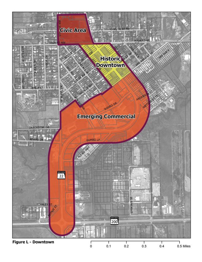
Downtown Plan.....................................................................................................................36
What Makes Downtown Thrive? ..................................................................................................................36
            Main Street ND: Putting Main Street to Work ..............................................................................36
Defining Downtown .......................................................................................................................................38
Challenges and Opportunities ........................................................................................................................40
Downtown Improvement Strategies .............................................................................................................41
            Business Development ......................................................................................................................41
            Understanding the Market ................................................................................................................42
            Downtown Aesthetics .......................................................................................................................42
            Improving Central Avenue ...............................................................................................................45
            Managing Vacant Property ...............................................................................................................46
Funding Sources...............................................................................................................................................46
            CDBG Mainstreet ..............................................................................................................................46
            North Dakota Renaissance Zone.....................................................................................................47
            North Dakota Development Fund ..................................................................................................47
            Lodging Tax ........................................................................................................................................47
            Local Option Sales Tax .....................................................................................................................47
            Local property tax incentives............................................................................................................48
            SBA 7a Community Advantage Program .......................................................................................48
            Business Improvement District .......................................................................................................48

Implementation ....................................................................................................................49
            Land Use/Development ...................................................................................................................50
            Economic Development ...................................................................................................................51
            Downtown ..........................................................................................................................................52
            Transportation ....................................................................................................................................53

City of Killdeer                                                                ii                                                    Comprehensive Plan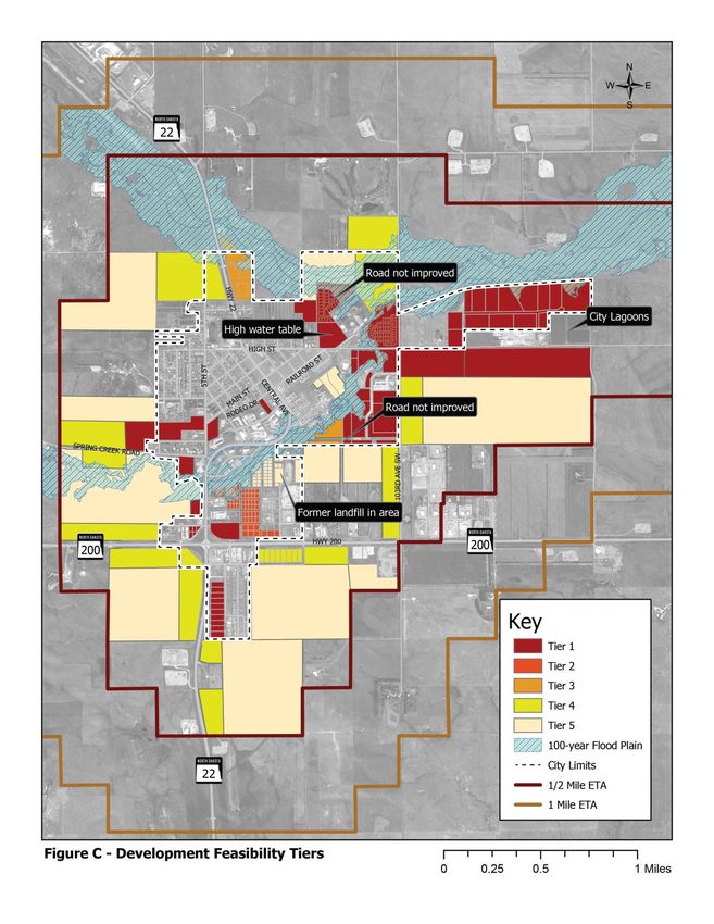
Goals and Strategies

This chapter summarizes Killdeer’s vision for growth and development, based
on input received from the community survey, public meetings, and discussion
with the Steering Committee. It provides a series of goals and strategies to
guide future decision-making. A goal is a general statement of a desired
outcome. Strategies help to carry out the goals. Some strategies describe
specific actions that the community could take to help fulfill its goals.

A. Attract and expand commercial and industrial businesses

Strategies
1. Pursue development opportunities that reinforce existing community
   strengths (e.g., new businesses which produce inputs to existing
   businesses).

2. Develop and strengthen relationships with regional industries.

3. Advertise platted lots with utility and infrastructure service and other
   development opportunities to regional developers.

4. Encourage infill development of available parcels with access to roads and
   utilities.

5. Provide strategic infrastructure improvements to encourage development
   in targeted areas.

6. Adopt flexible city ordinances that are pro-development.

7. Facilitate acquisition, land assembly, and land banking of vacant or
   underutilize properties. Work to acquire properties under public control
   and facilitate sale to regionally proven developers.

B. Help to grow and retain local businesses

Strategies
1. Prioritize businesses which provide specialized services or experiences,
   such as those which cannot be purchased online and which are more
   conveniently accessed in Killdeer than Dickinson (e.g., businesses which
   fulfill daily needs).
2. Apply flexible city ordinances that are pro-development.

City of Killdeer                                 3                              Comprehensive Plan
Goals and Objectives

3. Emphasize policy that supports local business (e.g., tax incentives for a
   local business startup).

4. Program and support community events that encourage patronage of local
   businesses.

C. Revitalize Downtown and the Central Avenue corridor

Strategies
1. Improve the appearance of aging structures that face Central Avenue.

2. Discourage the use of buildings for storage on Central Avenue.

3. Focus on creating the type of place where people want to stop, walk
   around, and visit.

4. Pursue opportunities to acquire vacant or underutilized properties.

5. Develop financing and coordinating mechanisms to direct investment to
   downtown (e.g., Renaissance Zone).

6. Program downtown events/activities throughout the year (e.g., summer
   street fair, concerts in the park, winter festival/sledding day).

7. Continue to coordinate with NDDOT to install targeted improvements
   along Central Avenue and ND Highway 22 to make the corridor more
   accessible for pedestrians and to improve safety and aesthetics.

8. Encourage the school and local and regional artists to create attractive
   public art installations in downtown (i.e. murals).

9. Expand evening entertainment options within downtown.

10. Focus investment around existing community assets (e.g., recent
    development along Rodeo Drive). Prioritize improvements for these
    locations.

11. Encourage and facilitate replats to support development of infill sites.

City of Killdeer                                   4                           Comprehensive Plan
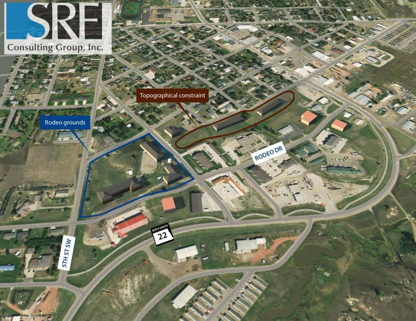
Goals and Objectives

Figure A. Rodeo Drive Infill Concept

Rodeo Drive extension with example infill development. Land use should tie in with recent development of
this area. Appropriate uses include commercial, multifamily, or civic uses. Sidewalks are planned for 5th
Street SW and Rodeo Drive.

D. Attract and retain families and youths

Strategies
1. Partner with schools, businesses, etc. to continue to expand activities and
   programming for children and teens.

2. Continue to provide and maintain a variety of recreation facilities and
   playground equipment and work with local families to ensure recreational
   needs are met.

3. Work with lenders, builders, and the business community to expand
   daycare options in Killdeer.
4. Increase single-family housing stock.

City of Killdeer                                                   5                                        Comprehensive Plan
Goals and Objectives

5. Continue to provide high-quality schools and learning opportunities.

E. Provide safe, convenient areas to walk and bike
1. Provide neighborhood pedestrian and bicycle connections to future school
   site.

2. Continue to work with NDDOT and other agencies as needed (i.e. Dunn
   County) to create safe crossings and school access.

3. Plan for sidewalks along future collector roads located within community
   growth areas.

4. Work to moderate and reduce where possible truck volumes and speeds
   through Central Avenue.

5. Along with new development evaluate the need and opportunity to
   construct an additional crossing over Spring Creek.

City of Killdeer                                6                             Comprehensive Plan
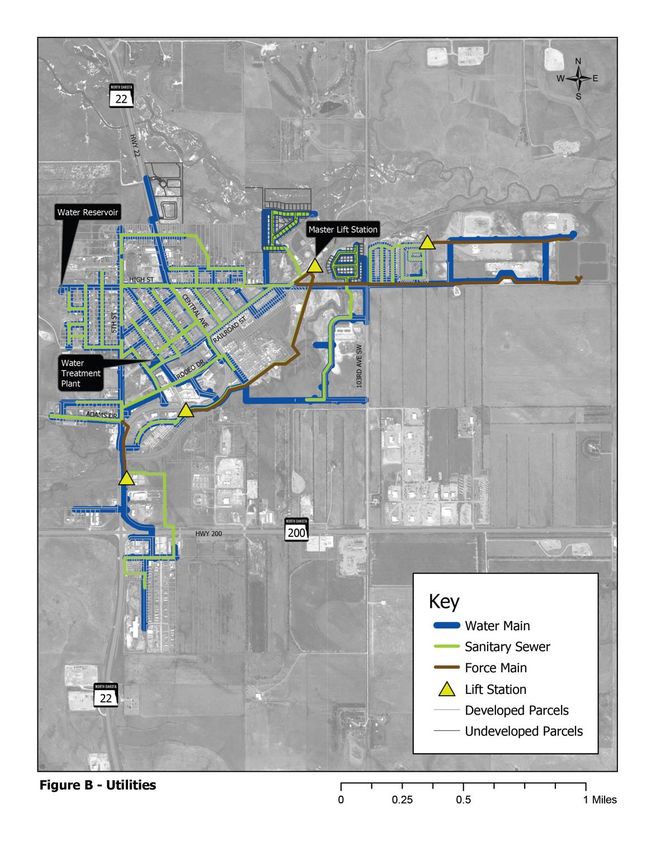
Land Use Plan

Introduction
This Plan serves as an update to the 2011 Land Use and Growth Management
Plan. While the 2011 Plan has served the community well, some changes are
needed to account for recent development, proposed development, and
changing growth trends. While Killdeer continues to experience growth –
growing school enrollment and business development point to a healthy
community – the pace of growth is not as rapid as it was in 2011. Killdeer will
need to work to develop new commercial assets, residential neighborhoods,
and family-friendly amenities that sustain its quality of life.

Development Opportunities
Most developments need access to water and sewer, the roadway system, and
electrical power. Specific development needs vary from use to use.
Commercial uses are most likely to locate within the two state highway
corridors. Many heavy industrial uses use large volumes of water. Other
industrial uses, like warehousing, do not need a water supply. Most industrial
uses can make do, and are encouraged to make do, with a limited roadway
network consisting of dirt or gravel surfaces.

It is the City’s responsibility to ensure that development is served by necessary
utilities and infrastructure. The cost of providing these facilities is typically
borne by the City. To reduce costs, development should be guided to areas
with existing utility access or areas into which utilities can easily be extended.
Conversely, since the City has a responsibility to make efficient use of public
money, it must avoid making public investments – including right-of-way
purchase – in areas which are not likely to develop.

Figure B maps existing water lines, sewer lines, and lift stations serving
Killdeer.

Figure C, Development Feasibility Tiers, depicts a range of development
opportunities based on the existing grids of water, sewer, and roads.
Undeveloped areas are ranked from 1 to 5, where Tier 1 is most suitable for
development. This graphic is intended to be a tool to help the City advertise
developable areas and attract private investment. Table 1 shows the criteria
that were used to classify each tier.

City of Killdeer                                    7                                Comprehensive Plan
Land Use Plan

Figure B. Existing Utilities

City of City of Killdeer       8   Comprehensive Plan
Land Use Plan

Figure C. Development Feasibility Tiers

City of City of Killdeer                  9   Comprehensive Plan
Land Use Plan
Table 1. Development Feasibility Criteria
Sewer
Tier Road Frontage Water Connection
Connection
1 ✓ ✓ ✓
2 ✓ ✓
3 ✓ ✓
4 ✓
5*
Many areas in Tier 5 are located within the floodplain. New structures typically cannot be constructed within
the floodplain unless they are elevated above the base flood elevation.
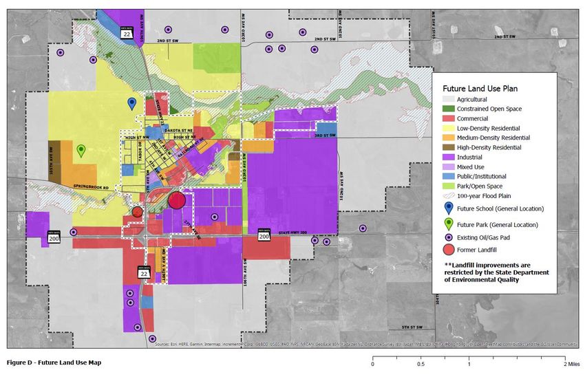
Future Land Use Plan
The Future Land Use Plan consists of the Future Land Use Map (Figure D),
which establishes a preferred future land use for areas within Killdeer’s
extraterritorial jurisdiction, and the accompanying text, which describes the
characteristics and expectations for each land use type.
The Future Land Use Map one of the most important elements of this Plan.
It provides a blueprint to help the City guide development to appropriate
locations. This map provides the basis for zoning. This section also includes
Growth Phasing Map (Figure E), which identifies the general timing that is
anticipated for development. Knowing where and when development is
expected sets expectations for property owners and developers, which
facilitates zoning, land transactions, and other decisions.
Table 2 provides the existing acreage for each land use category, the future
acreage, and the net change. This Plan introduces three new land use
categories: high-density residential, mixed use, and constrained open space. It
also eliminates the industrial/housing category from the previous plan. These
changes are reflected in Table 2.
City of City of Killdeer 10 Comprehensive PlanFigure D. Future Land Use Map City of Killdeer 11 Comprehensive Plan
Table 2. Summary of Existing and Future Land Use Acreages within Killdeer’s
         Extraterritorial Jurisdiction (up to 1-mile ETA)

                       Existing Land Use   Future Land Use
Land Use Category                                               Net Change
                              Map                Map

    Agricultural            6,082              3,916              -2,166

Constrained Open
                             393                431                +38
     Space

    Commercial               181                464               +2883

     Industrial              453               1,310               +857

Industrial/Housing            29                 0                  -29

    Low-Density
                             249               1,072               +823
    Residential
 Medium-Density
                              60                202                +142
  Residential
   High-Density
                              0                  51                +51
   Residential

    Mixed Use                 0                  13                +13

Park/Open Space              140                220                +80

Public/Institutional         108                113                 +5

      Vacant                 156                 0                 -156

Future Growth and Change
As Table 2 shows, the Future Land Use Map provides for a substantial increase
in residential, commercial, and industrial. However, note that growth areas on
the Future Land Use Map were actually reduced from the future land use
provided in the 2011 Plan. The decision to pare back the total acreage for
residential, commercial, and industrial land uses reflects the updated growth
assumptions for Killdeer and Dunn County. By reducing the city’s growth area,
this Plan aims to focus new growth adjacent to existing development, which
reduces the likelihood of costly leapfrog development and helps conserve
agricultural land as the City grows. The intent is to encourage Killdeer to grow
in an orderly, efficient manner, which reduces the cost of extending public
infrastructure and helps the City avoid creating obstacles to future growth.

City of Killdeer                                      12                           Comprehensive Plan
Land Use Plan
That said, the Future Land Use Map guides substantial acreage to
accommodate future growth. For example, the low-density residential category
shows an additional 950 acres. If this category were built out at an average
density of 2 units per acre (a modest assumption), and each household
averaged 2.5 persons, the low-density residential category would be able to
house 4,750 persons. The high-growth scenario projects a population increase
of roughly 1,000 by 2040 (See the Community Profile Appendix). Thus, the
Future Land Use Map does not indicate the likely extent of future growth as
much as it provides flexibility for future development to locate in a number of
appropriate areas. Areas which are most conducive to development will
develop first, while some areas will likely not develop within the timeframe of
this Plan. See the Development Phasing section for further discussion.
Using the Future Land Use Map as a Guide
The Future Land Use Map illustrates one appropriate configuration of future
land uses, but there may be other configurations which are appropriate for
specific areas. Therefore, the map will likely be modified from time to time.
See the section titled “Amending the Future Land Use Plan.”) Certainly, one
of the primary goals of this plan is to provide flexibility for commercial
development, both homegrown businesses and regional franchises, to locate
in Killdeer. Reasonable adjustments to the map can be made to support good
development opportunities. Therefore, it is appropriate to think of the map as
a guide rather than something fixed. As a guide, the map illustrates several
important planning concepts which should be inform future planning
decisions and map amendments. These concepts include:
• Mix of residential housing. It is important to consider how the Future
Land Use Plan supports a balanced housing supply. The map indicates an
appropriate proportion of low-density residential to medium-density
residential and high-density residential. While low-density residential is the
largest use by acreage, note that recent development has trended toward
high-density (i.e., multifamily apartments). Changing demographics,
household tastes, and an increasing need for affordability point to
increased supply of and demand for greater variety than simply single-
family homes and apartments.
• Location of high-density/high-intensity uses along higher-volume
roadways. Higher-density housing and commercial uses should be located
along busier roadways with more regional connections.
• General location of future parks and schools. The Future Land Use
Map illustrates the approximate location of the future elementary school
as well as a neighborhood park within a future residential area. While the
City of City of Killdeer 13 Comprehensive PlanLand Use Plan
exact size and orientation of these facilities is not determined, both parks
and schools are permitted uses within the Single Family Residential District
(i.e., low-density residential). Further, the map shows that future residential
development will need supporting parks and open space, especially if it is
located far from existing parks. Planning for future park facilities should
consider adjacent development (existing and proposed). To promote
greater park use and walkable design, it can be helpful to site parks next to
higher-density residential.
• Distinction between Commercial and Industrial. The distinction
between commercial and industrial uses is often blurred, especially in rural
areas. In Killdeer’s Land Development Code many of the same uses are
permitted in the C-Commercial District and the I-Industrial District.
However, it is important to note some key distinctions between
commercial and industrial areas. First, commercial areas generally attract
more vehicle traffic than industrial areas. While industrial uses can be
served by a loose network of gravel roads, commercial uses require good
accessibility and, typically, paved access roads and parking areas.
Commercial uses also require a high degree of visibility. Therefore, the land
adjacent to State highway corridors is prioritized for commercial use.
Note that the Future Land Use Map provides considerable acreage for
industrial to expand east of ND Highway 22, so there is a large area guided
for industrial development that is separate from commercial and other
uses. Dunn County has permitted industrial development in the past east
of ND Highway 22 and north of ND Hwy 200.
• Separation of uses. The Future Land Use Map encourages separation of
uses by largely guiding the growth area west of ND Highway 22 for
residential and the growth area east of ND Highway 22 for industrial. In
general, it is desirable to separate low-intensity uses such as single-family
residential from high-intensity uses as commercial and industrial. Land use
transitions can be accomplished through proper siting and landscaping
requirements. Roads are often used to provide a land use transition and in
other situations it is appropriate to use landscaping, fencing, or a buffer
strip to ease the transition between incompatible uses. For example, the
Future Land Use Map shows a buffer of open space the between industrial
and residential located along 103rd Ave SW. In some instances, it is
admissible to locate commercial/industrial adjacent to residential if care is
given to the orientation of buildings and roadways – for example, if the
rear yards of homes abut the rear of a commercial lot.
City of City of Killdeer 14 Comprehensive PlanLand Use Plan Future Land Use Categories Commercial Designated commercial land uses are shown in red. Areas shown as commercial are intended for retail sales and service, lodging, and office development. They are generally not intended for industrial sales and service or other activities of an industrial nature. The transition from commercial to residential areas is important. This transition could include a buffer of lower intensity commercial uses, parks and open space, deeper-than-normal yards, or higher-density forms of residential land use, such as townhomes or apartments. Commercial uses themselves typically serve as a land-use transition between high-volume roadways and residential areas, or between industrial and residential land uses. Many commercial businesses need and want to be visible to high volumes of traffic, which allows them to easily attract both local and regional clientele. For these reasons, commercial land use is placed along higher volume roadways such as ND Highway 22 and ND Highway 200. Maintaining a commercial corridor along ND Highway 22 will provide for better commercial visibility, access, and use of city services. Industrial Industrial land uses are shown in purple. In Killdeer, the identification of industrial land use areas is critical due to the demands of the oil industry and related industrial services, sales, and storage businesses. The location of these industrial uses is critical, as they typically generate large volumes of truck traffic and require large areas of outdoor storage. Industrial land uses typically include warehousing, light and heavy manufacturing, pipe yards, distribution, industrial service (repair or servicing of industrial, business, or consumer machinery, equipment, products or by- products), waste-related uses, large utilities, and mining. Heavy commercial uses such as gas stations, convenience stores, and fast food establishments can be appropriate within and adjacent to industrial areas, provided they have good highway access and their site design works to separate large trucks from personal vehicles. The Future Land Use Map guides a large area for industrial development east of ND Highway 22, extending the existing industrial footprint in this area up to the City lagoons. Truck traffic to and from this area should utilize 103rd Ave SW and eventually 102nd Ave SW to avoid ND Highway 22. Expansion of existing industrial areas is also appropriate in the northeast and southeast City of City of Killdeer 15 Comprehensive Plan
Land Use Plan

quadrants of the ND Highway 22/ND 200 junction, provided they do not
eliminate highway frontage designated for commercial. Industrial

Low-Density Residential
The low-density residential category is shown in yellow on the future land use
map. This land use category is primarily intended for single-family dwelling
units. This category is intended to provide housing ranging from 1-4 units per
acre. A range of lot sizes is intended to enable an appropriate mix to meet
varying household needs and budgets. Lot sizes could range from small,
affordable lots of approximately 6,000 square feet to large rural residential lots
of an acre or more outside city limits. The City is encouraged to pursue
compact forms of urban development, with subdivisions averaging 3-4 units
per acre. Compact development enables efficient extensions of public roads
and utilities, which lowers development costs and reduces public expenditures.
As an example, smaller lot widths can significantly reduce the infrastructure
costs (streets and utilities) ultimately paid by the homeowner.

 There are two main residential growth areas, including one located west of 5th
Avenue SW. Construction of the new elementary school, which may be located
within this area, will trigger residential development. The second low-density
residential area is located around the golf course and to the south. This area
includes several vacant subdivisions north of High Street which have already
been platted with utilities.

Medium-Density Residential
The medium-density residential land use designation is shown on the future
land use map in orange. It is primarily intended for low-scale multiple family
housing in the form of twin-homes and condominiums, with a density range
of 5-10 units per acre. It could also be considered for mobile home parks or
manufactured housing, which are important options for workforce housing
and smaller, more affordable households. In the 2011 Comprehensive Plan,
some areas which were intended to house temporary industrial workers were
designated as industrial/housing. In the 2019 Comprehensive Plan Update, the
industrial/housing category has been removed, and the former
industrial/housing areas have been reclassified as medium-density residential.

Medium-density residential is an appropriate buffer between low-density
residential and high-density residential (e.g., large multistory apartments) or
commercial. In some cases, medium-density residential can work where there
are limitations with lot size or access (e.g., infill).

City of City of Killdeer                           16                                Comprehensive Plan
Land Use Plan

High Density Residential
High-density residential is a new land use category in the 2019 Comprehensive Plan Update.

The high-density residential category is shown in dark brown on the Future
Land Use Map. This category is intended to differentiate large multifamily
apartment buildings, which often average more than 20 units per acre, from
medium-density residential. Since the 2011 plan was adopted, three apartment
buildings have been constructed – two buildings located on Rodeo Drive and
another located on 103rd Ave SW in a partially completed subdivision. Since
their completion, these buildings have rented at about 80 percent capacity,
which provides an appropriate stock of available units in the high-turnover
rental market. The success of these apartments could spell continued demand
for multifamily housing in Killdeer. In fact, multifamily housing may be more
readily developable than single-family subdivisions, since it is simpler to
prepare multifamily plats and units typically have a higher rate of return for
developers.

Multifamily apartments provide desirable workforce housing. However,
cannot be seen as the only solution to temporary workforce needs and they
need to be sustainable over the long-term.

In the short-term, it may be feasible to expand on the new multifamily
development located in the southwest quadrant of the intersection of High
Street and 103rd Ave SW. Apartments could also be incorporated into a
redevelopment plan for the former Rodeo Grounds; this area is designated as
Mixed Use on the Future Land Use Map. Finally, some areas which are shown
as commercial could conceivably support high-density residential, since
apartments and commercial are both suitable for higher-volume roads and are
likewise suitable to be located adjacent to one another. As an example, the
frontage along ND Highway 22 at the north end of town could reasonably be
used for multifamily.

Housing for the Senior Population
Specialized housing and facilities for the area’ aging population should be
allowed in the various residential land use categories. Despite Killdeer’s recent
and expected growth of young and middle-aged workers, the existing
population continues to age and will need senior living accommodations to
make it feasible for them to remain in the community. Single-level attached
housing and assisted-living apartments or townhomes are encouraged as part
of the housing mix to ensure desirable housing styles for senior citizens. The
continuing success of the Hill Top Home of Comfort is an example of the
demand for senior housing and care in the area.

City of City of Killdeer                                17                                   Comprehensive Plan
Land Use Plan

Mixed Use
Mixed Use is a new land use category in the 2019 Comprehensive Plan Update.

The mixed use category is shown in light purple on the Future Land Use Map.
It is intended to expand options for development, recognizing flexibility is a
key attribute of pro-development communities. The mixed use category is
appropriate for areas where 1) it is recommended to included more than one
type of use on the development site, or 2) there are multiple uses which could
be considered appropriate for a given parcel, tract, or building.

There are two types of mixed use developments: vertical mixed use and
horizontal mixed use. Vertical mixed use involves a single multi-story structure
or structures, in which the bottom story is typically used for commercial or
office space and upper stories are used for apartments. This arrangement is
typically found in high-density areas within larger communities, but is less
practical for Killdeer. Horizontal mixed use involves the combination of
several structures, each of which contains, usually, a single use. This type of
arrangement can be facilitated through a planned unit development (PUD) or
master plan.

The Future Land Use Map envisions mixed use for the former rodeo grounds
redevelopment site, which is an extension of the existing development pattern
along Rodeo Drive. Several existing commercial areas – mostly vacant – within
the historic downtown have also been re-designated as mixed use. This is not
to say that the commercial character should change, but that other, more
creative options should be considered to reinvigorate this area. Some
underutilized structures or lots could potentially be used for a variety of
purposes throughout the day, week, or year. Taking a creative approach to
mixed use could increase their utility.

Public and Institutional
The public and institutional category is shown in blue on the Future Land Use
Map. Land uses considered public and institutional include schools, religious
institutions, hospitals, government facilities, public facilities, and community
gathering places.

Constrained Open Space
Constrained Open Space is a new land use category in the 2019 Comprehensive Plan
Update.

Constrained open space is shown as dark green on the Future Land Use Map.
This category is primarily applied to the floodway and portions of the
floodplain in order to prevent development of structures or infrastructure.

City of City of Killdeer                            18                             Comprehensive Plan
Land Use Plan

Constrained natural areas can be developed with natural trails and limited
recreational facilities, but they are differentiated from parks in that they are not
intended provide space for organized activity, nor are they subject to public
maintenance.

Park and Open Space
The park and open space category is shown in light green on the Future Land
Use Map. This category refers to dedicated parks and playgrounds which are
maintained by the City. Areas located within the floodplain which were
designated as parks and open space in the previous plan have been re-
designated as constrained open space.

As discussed in the park and open space land use category, it is important that
neighborhood parks and city recreational facilities are incorporated into the
design of residential subdivisions. Approximately 10 percent of residential
acreage is appropriate as parkland. Open space can also use be used to buffer
residential areas from intense industrial or commercial activity.

Annexation and Phasing of Development
As development is proposed within Killdeer’s ETA, annexations will be made
to provide space for new development with city services. To guide
development in an organzied growth pattern, three development phasing areas
were created.

Figure E maps three phases of development in dark blue (Phase 1), blue (2),
and light blue (3) hatching. Each phase captures a portion of future residential,
commercial, and industrial. Areas which are already developed are shown in
gray. Areas located within Killdeer’s extraterritorial jurisdiction which are not
assigned a growth phase are intended to retain their agricultural use for the
foreseeable future.
Figure E is intended to provide guidance to city leaders, citizens, and
developers regarding annexation as well as development priorities. At this time,
this phasing appears to make sense for the City of Killdeer. Over time, a
different approach to phasing may be more practical or do a better job of
meeting the city’s needs. Each area is described below.

City of City of Killdeer                            19                                 Comprehensive Plan
Land Use Plan

Figure E. Growth Phasing

City of City of Killdeer   20   Comprehensive Plan
Land Use Plan

Phase 1
Phase 1 includes some areas within city limits that are already platted and/or
have access to utilities, but have yet to develop. Phase 1 also includes some
areas just outside city limits which have potential to develop in the near future,
but which require annexation. Phase 1 areas might reasonably develop within
the next 5 years, depending on the rate of growth. Infill development within
city limits is the highest priority.

Phase 2
Phase 2 is represented with blue hatching. It includes several large tracts that
are mostly guided for future low-density residential or industrial, as well as
highway commercial areas that are located outside city limits. In some areas,
development will be triggered by key events, such as the construction of the
new elementary school in the northwest quadrant of the city, or the extension
of roads and infrastructure. Phase 2 also sees development branching out along
primary corridors, including existing and future arterials and collectors, while
most areas interior to these roads are anticipated to develop in Phase 3. Phase
2 areas might reasonably develop within the next 5-10 years.

Phase 3
Phase 3 is represented with light blue hatching. Phase 3 includes areas within
Killdeer’s extraterritorial jurisdiction that are less favorable for development
than areas in Phase 1 or Phase 2. Phase 3 areas are not anticipated to develop
for 10-20 years or beyond.

City of City of Killdeer                           21                                Comprehensive Plan
Land Use Plan

Amending the Land Use Plan
Land use plans need to be amended from time to time when the city’s needs
change, or when a worthy development proposal that garners the support of
the community and adjacent property owner requires a zoning change that is
inconsistent with the adopted land use plan.

While the plan is to serve as a guide for zoning and subdivisions, and as such
is meant to be referred to on a frequent basis as developers come forward with
proposed projects, it is important to acknowledge that the plan is a living
document. It is meant to be drawn on, tweaked, refined, and have detail built
into it from the inside out, starting with the most immediate growth areas
adjacent to existing development. It is not meant to be ignored or relegated to
the status of irrelevant as wholesale changes are made without regard to how
they affect other planned land uses in the surrounding area. The best way of
keeping a land use plan up to date and relevant is to follow a formal process
for considering amendments to the plan. No matter how much study and
scrutiny is put into the original development of a land use plan, over time
existing and future property owners will see different opportunities and
constraints with respect to the use of land. These opportunities will not justify
amending the land use plan in all cases, but in some cases, a change may be a
positive step.

The North Dakota Century Code requires that zoning decisions are based on
a comprehensive plan. If for no other reason than this, it is necessary for the
City of Killdeer to act in accordance with the plan, or to carefully consider
amendments to its plan based on an approved process. It is important for the
City to have a track record of following its plan and/or making thoughtful
amendments to the plan based on an approved process, so potential
developers can see that the City has respect for the process and for the public
when considering prospective development.
When a proposal is made that is not consistent with the plan, this should be
identified prior to the project being placed on an agenda for a zoning change
or subdivision. Inconsistency could be in the form of:

•   Land use (the type or size of a proposed land use area),

•   Specific land uses allowed by the proposed zoning district that would be

•   inconsistent with the intent of the plan, or

•   Street or highway alignment and/or continuity.

For example, if industrial zoning is proposed where commercial land use is
shown on the land use plan, this is an inconsistency, since industrial land use

City of City of Killdeer                           22                               Comprehensive Plan
Land Use Plan

has its own designation. If the property owner wishes to pursue a zoning
application for the industrial zoning district, he/she must also request a land
use plan amendment. If a subdivision is proposed that does not include right-
of-way for a collector street connection that is shown in the plan, this is an
inconsistency that must be corrected, or the plan must be amended with some
acceptable alternative, if one is found to exist.

The process of amending the land use plan is as follows:

1. Identify the inconsistency. Prepare a sketch of the proposed land use
change. This can be as simple as drawing on a copy of the land use plan, or
using tracing paper over the land use plan to show the proposed change. It is
important for the property owner to decide if they wish to move ahead with a
land use plan amendment. The issues should be discussed with City staff
responsible for planning, engineering, and zoning administration. A meeting
with surrounding property owners may be advisable at this stage.

2. Application. Require the property owner to apply for a land use plan
amendment if they wish to move ahead with their proposal.Public notice
similar to that of a zoning change should be required prior to both the Planning
and Zoning Commission and City Commission hearings. Mailings to
surrounding property owners, notifying them of the proposed change, should
be mailed in advance of the hearings.

3. Staff analysis. Provide an analysis of the following findings associated with
the proposed change:

•   Is the proposed land use compatible with existing land uses, existing
    zoning designations, or approved subdivisions?

•   Is the proposed change compatible with surrounding future land uses, or
    does it result in the need for other land use plan changes to bring about
    future land use compatibility? If so, have those changes been included in
    theproposed amendment?

•   Does the proposed change result in the need for changes to streets and
    roadways to bring about existing or future continuity and connectivity? If
    so, have those changes been included in the proposed amendment?

•   Can the proposed change be accommodated by the surrounding
    infrastructure (roadways and utilities)?

•   Is the proposed change consistent with the other adopted plans and
    policies of the city?
4. Planning and Zoning Commission Public Hearing. Based on the staff
findings and recommendations, combined with the input received at the public

City of City of Killdeer                          23                               Comprehensive Plan
Land Use Plan hearing, the Planning and Zoning Commission is to determine if it agrees with the findings of staff or if it feels differently on some point. The Planning and Zoning Commission should document its findings and share them with the City Commission along with a recommendation for approval or denial of the requested land use plan amendment. 5. City Commission Public Hearing. Based on the staff findings and recommendations, along with those of the Planning and Zoning Commission and the input received at the public hearing, the City Commission needs to determine if it agrees with the findings of staff and the Planning and Zoning Commission. If the Commission feels differently on some point, they must be careful to document the findings that led them to approve or deny the requested land use plan amendment. 6. Modify the Land Use Map. If the land use plan amendment is approved, the map needs to be revised to show the approved change. An updated map should be posted on the City’s website, both as a stand-alone map and as a part of this document. Once steps 1-5 have been taken, the City will have completed its review and consideration of a proposed land use amendment. If approved as part of step 5, the change will be official, and only step 6 will remain as a matter of completing the process by communicating the change on the land use map. City of City of Killdeer 24 Comprehensive Plan
Transportation Plan

Future transportation system
Transportation and land use planning go hand in hand. The Future Land Use
Map was designed with transportation in mind. The placement and orientation
of future land uses accounts for desired future travel connections and likely
road extensions. Figure F shows these extensions and connections. Figure J at
the end of this chapter overlays these features on the Future Land Use Map.

City of Killdeer                                 25                             Comprehensive Plan
Figure F. Future Road and Trail Concepts

City of Killdeer                           26   Comprehensive Plan
Figure G below summarizes the functional classification system of a typical
city. It provides guidance for the percentage of roadway miles that typically fall
into each classification (e.g., 75% local streets) and the intent of each roadway
type – whether it emphasizes high-speed mobility, unrestricted access, or a
combination of access and mobility. Note that the graphic also implies which
jurisdictions are typically associated with each roadway type.

Figure G. Functional Classification Graphic

Arterial Streets
Arterial streets include ND Highway 22, ND Highway 200, and the ND
Highway 22 Bypass, all of which are operated and maintained by NDDOT.
These highways are all classified as minor arterials, but their functions differ
slightly.

ND Highway 22
ND Highway 22 is a critical corridor that provides local and regional
connectivity. It is the only extended corridor that has continuity across Spring

City of Killdeer                                    27                               Comprehensive Plan
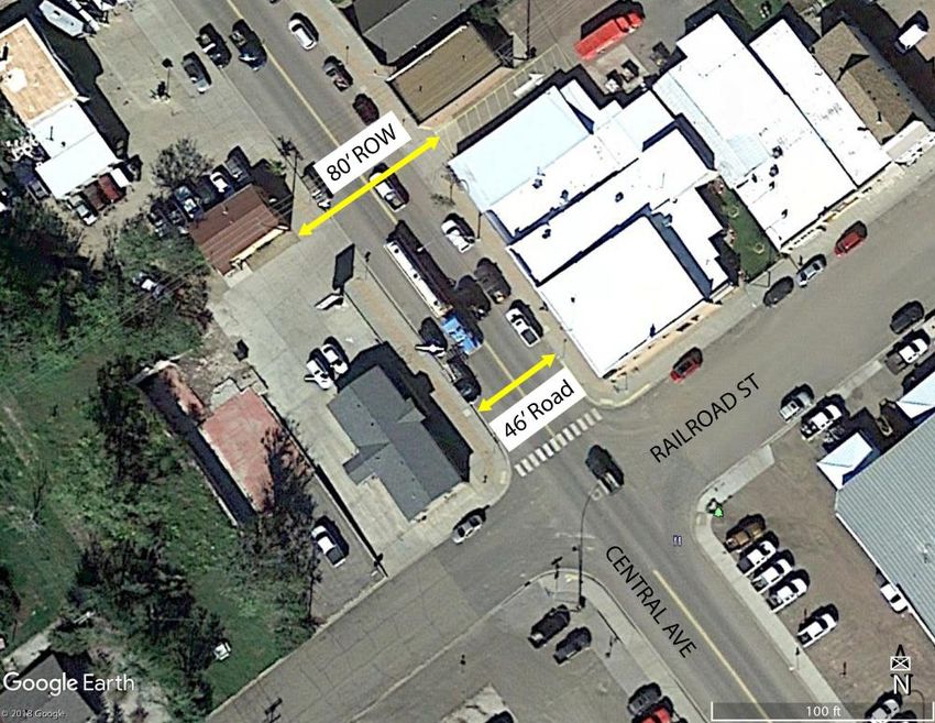
Transportation Plan

Creek and Gumbo Creek. It serves a variety of functions, which can create
conflicts between various users. Even with construction of the bypass, there
are still high truck volumes on Central Avenue. There are also facilities for
pedestrians and bicyclists, with a planned extension of the shared use path.
Much of land adjacent to the corridor is built out, but redevelopment could
create opportunities to consolidate or eliminate access points where they pose
a crash risk.

ND Highway 22 Bypass
Unlike ND Highway 22, the bypass serves a high-speed, limited-access
function that is more typical of principal arterials. This highway traverses a
rural area with very limited development. To retain its function, access to the
bypass will need to be carefully managed. Although the bypass could
theoretically attract commercial or industrial development, there are no urban
utilities or service roads in this area. If this corridor ultimately draws
development interest, development will need to be carefully planned. The
corridor is not located with within Killdeer’s extraterritorial jurisdiction, so the
City cannot exercise land use controls, but it can partner with Dunn County
to develop standards that are amenable to both jurisdictions.

Collector Streets
Collector streets are particularly important. These are the highest-order roads
in Killdeer’s jurisdiction. Collector streets have greater continuity than local
streets and typically serve a balance of access and mobility functions.
Therefore, they should include accommodations for pedestrians and bicyclists
as well as motor vehicles. Right of-way will be wider for future collectors than
for local streets so that these paths can be incorporated. Killdeer’s existing
Land Development Code requires sidewalks on both sides of collector streets.

Killdeer’s Land Development Code provides dimensional standards for streets
and right-of-way. The minimum right-of way for collector streets is 78’, which
is sufficient for 2-3 travel lanes, two rows of parking, two walking paths, snow
storage, and utilities. For reference, this right-of-way width and roadway
configuration is approximately what exists on Central Avenue, a minor arterial.
Not all features will be needed on every collector road – i.e., double parking
may be unnecessary or unadvisable in some instances – but it is important to
preserve sufficient right-of-way to provide flexibility for future improvements
that may be needed.

City of City of Killdeer                            28                                 Comprehensive Plan
Transportation Plan

Local Streets
Local streets provide direct access to development. All local streets are
maintained by the City of Killdeer or Dunn County. The minimum right-of-
way varies from 40’ to 56’, depending on parking needs.

Local street design should accomplish the following:

•   Provide sufficient access for emergency vehicles

•   Maximize the efficient use of space for utility and drainage infrastructure

•   Ensure direct connectivity and continuity throughout the community

•   Manage parking supply to match the character of the street

•   Minimize street and ROW widths to maintain a walkable environment and
    reduce costs

•   Provide ADA-complaint accommodations for pedestrians

Access Management
As the access-mobility graphic shows, high-speed roads such as arterials and
some collectors emphasize mobility over access. In order for these roads to
safely serve their function, access spacing should be carefully managed. Access
management is especially important for arterials such as ND Highway 22 and
ND Highway 200. Killdeer will carefully review all land development
applications for access spacing issues to prevent driveways and intersections
from being too closely spaced. In addition, there may be opportunities to
improve safety by consolidating the number of existing driveways, especially
on ND Highway 22 and Central Ave.

Access management is also important on other rural section line roads that will
ultimately become collector roadways. Consolidating access and providing
ample spacing between intersections and driveways will minimize the number
of conflict points, which has been shown to reduce crashes and increase safety
for the traveling public. Minimum spacing of 1/8 mile (660 feet) is typically
recommended inside city limits and in the city’s fringe growth areas, while
minimum spacing of ¼ mile (1,320 feet) is recommended in rural areas,
including State Highways.

Individual access points should be discouraged along these corridors. Direct
site access should be oriented onto side streets shared with other developments
or other forms of consolidated access should be provided, such as frontage
roads. Where a driveway is unavoidable, more than one business can share an
access, or individual site access should be aligned with other driveways across

City of City of Killdeer                          29                              Comprehensive Plan
Transportation Plan
the highway, thereby limiting turning movements to a single location rather
than random locations along the highway.
Table 3 below provides guidelines for determining the minimum spacing
requirements. Note that access spacing is more strict in the rural area (i.e,
Killdeer’s extraterritorial area and beyond) than the urban area. For example,
direct points of access to the northwest bypass should be spaced no closer
than ½ mile.
Table 3. Access Spacing Guide
Urban Area (City Limits) Rural Area (ETA)
Street Type
Intersections Driveways Intersections Driveways
1/8 mile to ¼
Minor Arterial 330’ 1/2 mile ¼ mile
mile
1/8 mile to
Collector 330’-660’ 150’ 330’-600’
¼ mile
Local 330’-660’ 50’ 660’ 330’
Right of Way Preservation
Right-of-way is a valuable public asset. Therefore, it needs to be protected and
managed in a way that respects its intended function. Many future collectors
will be constructed on section lines. In some cases, partial right-of-way exists,
but the City will have to expand/extend right-of-way as needed. When future
expansion or realignment of a collector road is proposed, but not immediately
programmed, Killdeer should consider right-of-way preservation to reduce
costs and maintain the feasibility of the proposed improvement. The
development phasing map (Figure E) can be used as a guide to determine the
timing of right-of-way acquisition.
Right-of-way can be preserved through advance purchase, zoning and
subdivision techniques, or official mapping. Prior to preserving corridors for
roadway expansion, the City will review environmental issues and perform
environmental documentation if necessary to ensure that it does not preserve
unusable right-of-way.
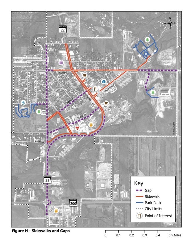
City of City of Killdeer 30 Comprehensive PlanTransportation Plan Roadway System Preservation Roadway system preservation is a critical aspect of transportation planning, especially in for rural communities like Killdeer, which has limited funding and limited control over how funds are used. Regular maintenance such as filling potholes, applying protective coatings, and snowplowing help extend the life of a road. Similarly, regular repair such as more intensive resurfacing can ensure that small problems which can be handled in a cost-effective manner are addressed before they become major issues. On the other hand, it is important to have a sense of where and when major improvements will be needed to avoid spending money for short-term “band-aid” fixes. It is critical to monitor the quality of roads and maintain a short-term improvement plan. Killdeer Public Works employs a “fix-it” first approach to system preservation, but it is expected that some repair projects will be prioritized over others. It may be helpful to develop simple criteria for determining when repairs should be made. This determination might be based on engineering metrics, roadway classification, cost, and other factors. Sidewalks Figure H shows the existing system of sidewalks and paths in greater detail. A gap analysis was used to identify desired pedestrian routes and prioritize locations where sidewalks should be added. For the most part, the City is already planning to fill in these gaps. Completing the shared use path on ND Highway 22 is a critical project. Adding sidewalks along 5th Street is also a high priority. A complete path connection should be extended from 5th Street to the future school. Adding paths to Rodeo Drive would support development in this area. The other gaps are lower priorities. Killdeer’s Street Dimensional Standards specifies requirements for provision of sidewalks on local streets, collectors, and arterials. The standards include sidewalks on both sides of every arterial, local street, and collector street. However, note that most existing streets in Killdeer lack sidewalks. Sidewalks are expensive to construct and maintain, and they are not needed on every street. Killdeer should consider amending this section of ordinance to allow for more flexibility. It may be helpful to develop additional classifications of local streets – e.g., residential neighborhood street, transitional street, light industrial street, etc. – to manage sidewalk standards and other design elements. City of City of Killdeer 31 Comprehensive Plan
Transportation Plan

Figure H. Sidewalks and Gaps

City of City of Killdeer       32   Comprehensive Plan
Transportation Plan

Roadway System Recommendations

1. Develop local street standards
Killdeer’s Land Development Code contains general standards for local
streets. However, there is no one-size-fits-all local street. Given that local
streets serve every conceivable land use and neighborhood type, it may be
helpful to expand the classification system and develop more specific
standards for local streets. The City already differentiates between the
industrial street system and non-industrial streets (industrial streets are
surfaced with gravel or dirt). By further developing classifications for local
streets, Killdeer could clarify its standards for sidewalks, landscaping, access,
parking, etc. Another outcome would be greater flexibility for determining
right-of-way and street width.

2. When possible, modify access and alignments to improve safety and
   connectivity
As discussed, access management is critical for arterial corridors, and should
be considered during planned highway improvements. Additionally,
development or redevelopment of property adjacent to the roadway may
create an opportunity to consolidate or eliminate direct driveway access to ND
Highway 22 or ND Highway 200.

City of City of Killdeer                          33                                Comprehensive Plan
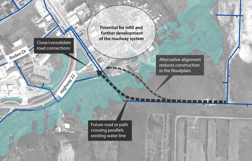
Transportation Plan

3. Explore Spring Creek Crossing Feasibility
Spring Creek and the surrounding floodplain pose a development constraint.
Currently, there are two crossing locations – one on ND Highway 22 and one
on High St NE. These crossings are more than a mile apart. As development
on the east side of town increases, a third crossing would be desirable and
would improve connectivity to and from downtown. This discussion was
raised during steering committee meetings. It would be challenging to navigate
the floodplain and tie into the existing development pattern but if there is
further development on the east side of the city, the benefit of constructing a
new crossing could outweigh the cost. Figure I illustrates a concept for linking
connecting east-side development to downtown via a new route.

Figure I. Conceptual Spring Creek Crossing

City of City of Killdeer                          34                               Comprehensive Plan
You can also read