A study of communities of interest in Wellington Region - February 2016 - Local ...
←
→
Page content transcription
If your browser does not render page correctly, please read the page content below
A study of communities of interest
      in Wellington Region

            February 2016
TABLE OF CONTENTS

Introduction …………………………………………………………………………………………………………………………......... 3

Part A: General approach to identifying communities of interest .………………………………………………          4

Part B: Application of approach to Wellington Region …………………………………………………………………               8
        Wellington Region ……………………………………………………………………………………………………………                          8
        Wellington City ………………………………………………………………………………………………………………..                        17
        Porirua City ………………………………………………………………………………………………………………………                          21
        Kapiti Coast District ………………………………………………………………………………………………………….                     24
        Lower Hutt City ………………………………………………………………………………………………………………..                        28
        Upper Hutt City ………………………………………………………………………………………………………………..                        31
        The Wairarapa ……………………………………………………………………………………………………………......                       33

Appendices:
      Table 1:   Wellington Region territorial authority district profiles ……………………………………   38
      Table 2:   Wellington Region territorial authority demographic profiles ………………………….   39
      Table 3:   Travel to work data in Wellington Region ………………………………………………………..           40
      Table 4:   BNZ cardholder spending and transactions in Wellington Region …………………….    41
      Table 5:   Wellington regional amenities, organisations and events ………………………………..     43

                                                                                  Page 2 of 43
Introduction
1. The Local Government Commission, with the assistance of the councils and communities of
Wellington Region, is looking at the current local government arrangements with a view to
ensuring these are the best possible arrangements to provide ‘good local government’ for
the people of the region.
2. ‘Good local government’ is seen as a set of arrangements that best promote the purpose of
local government as set out in section 10 of the Local Government Act 2002. This purpose
has two parts:
a. to enable democratic local decision-making and action by, and on behalf of,
communities
b. to meet the current and future needs of communities for good quality local
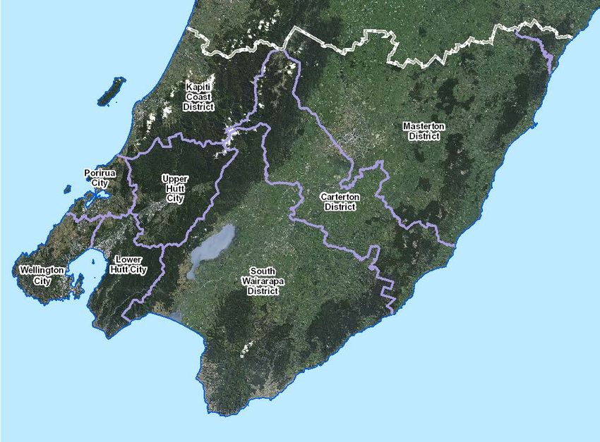
infrastructure, local public services, and performance of regulatory functions in a way
that is most cost-effective for households and businesses (with ‘good quality’ meaning
efficient, effective and appropriate to present and anticipated future circumstances).
3. It is noted that while the purpose of local government relates to local or community level
governance of an area, there is no definition of the term “community” as used in the context
of section 10.
4. In the absence of statutory guidance, the Local Government Commission intends applying
the concept of community of interest to assist it in the study of local government
arrangements in Wellington Region. This is a useful tool given one of the statutory criteria for
identifying reasonably practicable options for local government reorganisation is a
requirement for a district to contain one or more “distinct communities of interest”. In
addition, importance is placed under the Local Electoral Act 2001, on regular council reviews
to ensure ongoing “effective representation of communities of interest”.
5. This paper applies the concept of community of interest to Wellington Region in order to
help assess whether the current local government arrangements are best for promoting
‘good local government’ in the region. This includes assessment of the appropriateness of
current local government boundaries as groupings of one or more communities of interest.
6. A draft of this paper was sent to the councils in the region for input and comment. Any
further input or comment on the paper is welcome.
Page 3 of 43PART A: GENERAL APPROACH TO IDENTIFYING COMMUNITIES OF INTEREST
7. The approach taken assumes a broad view of the concept of community of interest. It
encompasses both subjective and objective views of what a community of interest
constitutes. The approach is based on the working definition of community of interest
developed by Helen Fulcher 1 as applying to a particular locality and having one or more of
the following three dimensions:
a. Perceptual: a sense of belonging to an area or locality which can be clearly defined.
b. Functional: the ability to meet with reasonable economy the community’s requirements
for comprehensive physical and human services.
c. Political: the ability of the elected body to represent the interests and reconcile the
conflicts of all its members.
8. The three dimensions are quite different in nature, ranging from highly subjective to clearly
objective and therefore more easily measurable. A particular dimension can also exist
simultaneously at different levels e.g. the local/neighbourhood level, district level and
regional level.
9. It is acknowledged that since Fulcher prepared her paper over 26 years ago, there has been
significant societal change and this will continue. This change includes technological
developments that have impacted dramatically on how people, particularly younger people,
interact with virtual and other non-geographically defined ‘communities of interest’. While
such changes need to be taken into account, local government is, and will for the foreseeable
future remain, geographically defined and therefore this approach based on the three
identified dimensions remains relevant.
10. While the three identified dimensions of community of interest are important individually in
helping assess ‘good local government’, they do overlap and are often interwoven.
Consideration of one dimension may, therefore, also involve to some degree another
dimension.
11. The perceptual dimension of community of interest, for example, is important in the sense
that if people feel a sense of belonging to an area they are more likely to engage in local
community affairs often involving interaction with their local council, and to participate in
activities like local elections. The perceptual dimension is then related to appropriate
representation and decision-making structures needing to be identified under the political
dimension of communities of interest.
12. The functional dimension clearly relates to the purpose of local government in respect of
provision of good quality services, now and into the future, in the local area. Fulcher
identifies four conditions relating to the functional dimension of community of interest
which overlap the other two: the physical (and perceptual) distance from the administrative
centre; communities of interest not being divided by municipal boundaries; recognising the
interdependence of service centres and the surrounding countryside in rural areas;
boundaries being easily identifiable and having regard to boundaries defined and used by
other government and statutory bodies.
1
Fulcher, H., (1989), South Australian Department of Local Government, A Discussion Paper Which Explores
The Concept of Community Of Interest As It Applies To Local Government Boundaries
Page 4 of 4313. Recognition of both perceptual and functional dimensions is likely to result in the
identification of different scope and scale communities of interest. The political dimension
can then be used to achieve a balance between these dimensions in determining appropriate
representation and decision-making structures for the ‘enabling of democratic local decision-
making and action for, and on behalf of, communities’.
Identifying perceptual communities of interest
14. Fulcher notes that “communities show considerable diversity in the nature and strength of
the networks which operate, both overtly and covertly, between local residents. In
perceptual terms, community of interest may range from virtually non-existent, to transient,
to a proud local tradition … in some localities, the physical proximity and daily interaction of
residents in activities such as shopping, recreation, and worship may create only loose-knit
networks … in other areas, people’s interactions may be more neighbourly … in other
localities (for example long-established rural communities), there may be a strong network of
people, who are proudly self-sufficient and actively demonstrate their compatibility and
common outlook.”
15. Fulcher cites evidence that perceptual communities of interest are likely to be more
identifiable at a more local level than the district level. This evidence includes a study
undertaken in South Australia on the attitudes of people to their “home area” or the area
they felt they belonged and with which they identified. This found for people living in council
areas fewer than 20,000 people, most identified the “area” in which they felt “at home” as
the local government area. Above 20,000, perceived communities were smaller than the
actual population of the local government area. Fulcher also cites the Maud Royal
Commission’s survey of community attitudes across England in 1969 which found that in
urban areas, most people defined the “home” area by the group of roads within ten minutes
walk of their residence, and in smaller boroughs, with the whole town.
16. Commission officers are not aware of similar surveys on perceptions of size of “home areas”
being undertaken in New Zealand but consider the above findings are likely to have some
relevance here.
17. Particular factors seen as likely to contribute to or reinforce perceptions of local communities
of interest include:
• the evolution of local government i.e. establishment/mergers of former counties and
boroughs in the area leading to the present now familiar structure, with associated
sense of identity and belonging
• the geography of the area and significant physical features as they relate to land-use and
patterns of development, and then to feelings of difference and separateness
• groupings of communities within a district into wards/community board areas reflecting
geography and other factors such as similarities in socio-economic characteristics.
Identifying functional communities of interest
18. Fulcher describes the functional dimension of community of interest as referring to “the
interactions of the community, the sense of common activities such as trade, sport and
schooling, and common needs for area-based facilities and amenities”. In short, these
interactions may be described as relating to where people live, work and play.
Page 5 of 4319. An example of the significance of these interactions in relation to different communities is
shown in an Auckland study on the role of schools in parents’ sense of belonging to a
community. 2 In this study Māori and Pākehā parents indicated that schools and preschools
were the most significant sites to their community belonging. For Pacific and Asian parents,
the church was more important.
20. Fulcher identifies factors relating to measurement of the functional dimension including the
distance factor and the importance of telecommunications in reducing the impact of
distance, and the extent of local government’s role as a provider of services. She also notes,
in addition to measuring current use, the importance of assessing future demand through
analysis of census data: “accurate demographic profiles of factors such as age, occupation,
incomes, housing and family types, home ownership rate and recipients of welfare benefits,
will indicate how homogeneous or stable the community is and the likely direction of
changing needs relevant to council planning and policy”.
21. The following factors are seen as important in identifying functional communities of interest,
in some cases building on or reinforcing perceptual factors:
• current broad land-use patterns (residential, commercial, rural) as they relate to where
people currently live, work and play
• travel to work data i.e. the extent people stay within or travel out of the district to work
• location of spending data i.e. the extent people shop in or out of the district
• the range of community, recreation, cultural facilities and services within existing
districts
• location and usage patterns of ‘regional’ facilities
• current catchment areas for the delivery of core local authority infrastructure and
regulatory services including the extent of shared or joint arrangements
• flows of goods and services within and out of the region including the role of key
infrastructure i.e. port, airport, state highways
• current catchment areas for the delivery of important non-local government services
e.g. health, education, social welfare.
Identifying political communities of interest
22. Fulcher notes the political dimension of community of interest “relates to the ability of local
government to represent the interests of all its members”. She says while there is a need for
local government to define and represent an area that is a coherent social and economic
unit, there are still likely to be diverse identities, needs and priorities clustered together
within that unit.
23. Fulcher goes on: “(t)he political dimension of community of interest needs to acknowledge
the existence of such diversity, be able to reconcile conflicts of interest and differing
priorities, and bring policies to fruition. To do so effectively, there must be public confidence
in local political leaders and in the ability of local activity to influence decision making
processes. Resident interest and involvement in local politics will in turn foster the
perceptual dimension of community and enhance the workings of local government as
community government”.
2
Witten, K., McCreanor, T. and Kearns, R., (2007), The place of schools in parents’ community belonging, New
Zealand Geographer Vol 63, pp 141 – 148
Page 6 of 4324. As previously noted, assessment of perceptual and functional dimensions of community of
interest may result in different scale communities being identified. This requires careful
assessment when identifying arrangements to reflect appropriate political dimensions of
communities of interest. This tension is demonstrated by analysis of local authority election
results in New Zealand which shows smaller local authorities, i.e. with a population less than
20,000 (in line with Fulcher’s cited South Australian study), have tended to have distinctly
higher levels of voter turnout than larger authorities. This fact may be seen to reflect a
stronger sense of identity with, and belonging to, smaller communities translating into higher
levels of engagement and participation. While acknowledging that factors affecting voter
turnout are inherently complicated, this finding relating to the perceptual dimension of
community of interest needs to be considered against the functional dimension which may
suggest larger areas, on grounds of efficiency, are more appropriate.
25. In summary, factors seen as important in identifying political communities of interest
include:
• local government electoral arrangements within districts i.e. constituencies, wards,
community board areas reflecting distinct communities of interest, including the
projected degree of change in particular socio-economic factors as they impact on those
arrangements
• the existence and nature of other local social, cultural, ethnic communities which may
cut across some electoral boundaries
• hapū/iwi/Māori areas of interest and associated structures
• parliamentary electorates
• central government agency structures
• non-governmental structures e.g. chambers of commerce, federated farmers
• local interest groups including ratepayer and resident groups.
26. Local government representation and decision-making structures need to be designed to
reflect a range of interests and to assist the reconciliation of diversity, conflicts and differing
priorities. At the same time there is a need to consider efficiency, effectiveness and
sustainability in the delivery of services to meet community needs. In summary, criteria for
‘good local government’ arrangements, guided by the purpose of local government, are seen
as follows:
• enabling democratic local decision-making and action by, and on behalf of, communities
with arrangements that:
o reflect whole communities of interest grouped as appropriate
o provide fair and effective representation
o do not create barriers to participation e.g. at elections
• meeting current and future needs of communities for good quality local infrastructure,
local public services and regulatory functions in a way that is most cost effective for
households and businesses with arrangements that are:
o efficient (achieve maximum economies, avoid unnecessary duplication, match the
area of benefit with the area that pays)
o effective (meet statutory responsibilities and the identified needs and priorities of
the community, households, businesses)
o appropriate to present and anticipated future circumstances.
27. Part B applies these criteria to Wellington Region.
Page 7 of 43PART B: APPLICATION OF THE APPROACH TO WELLINGTON REGION
28. This Part sets out information to assist the identification of the perceptual, functional and
political dimensions of communities of interest in Wellington Region. It sets this out firstly in
relation to the region as a whole and then on a district by district basis.
WELLINGTON REGION
Evolution of regional governance
29. From 1853 to 1876 New Zealand was divided into, initially six, and then nine provinces with
each having its own superintendent and directly elected provincial council. The Wellington
Province originally included all of the southern part of the North Island excluding Taranaki,
with Hawke’s Bay subsequently excluded to form its own province in 1858.
30. On their abolition in 1876, the provinces were replaced by a raft of boroughs and counties
across the country, the number of which quickly multiplied (see below under individual
territorial authorities for details of the history of the boroughs and counties in each part of
the greater Wellington area).
31. Given the small scale of the resulting local authorities and their limited functions, the need
for further special purpose authorities quickly arose such as a Hutt River Board in 1899. The
first special purpose local authority of a regional nature in the Wellington area was the
Wellington Harbour Board established in 1880 to further develop and operate Wellington's
port. Its electoral area eventually included the Wairarapa and parts of the Manawatu.
32. Further organisations of a regional nature were established in the 1940s. Following
enactment of the Soil Conservation and Rivers Control Act in 1941, the Manawatu and
Wairarapa Catchment Boards were established in 1943 and 1944 respectively, to deal with
flood control and soil conservation in those areas. For the Wellington metropolitan area, a
Wellington Regional Planning Authority was established in 1945 to coordinate planning and
urban growth.
33. In 1972 the Wellington Regional Water Board was established to take over bulk water supply
from the territorial authorities and to assume responsibility for water and soil conservation.
34. Then in the late 1970s, a co-ordinated New Zealand-wide system of regional government was
established responsible for certain functions needing to be carried out at a scale beyond the
territorial authority level. For the Horowhenua and Wairarapa regions, united councils were
established. These had responsibility for regional planning and regional civil defence, as well
as providing necessary coordination between the territorial and special purpose authorities
in the region. The members of a united council were appointed by the territorial authorities
in that region. In the Wellington Region a directly elected regional council was
established. It took over the functions of the Wellington Regional Water Board and the
Wellington Regional Planning Authority, and had responsibility for regional civil defence.
35. The current Wellington Region was constituted in 1989 as part of comprehensive local
government reforms across the country. The region brought together eight territorial
authority districts and a small part of a ninth district, as well as a number of special purpose
bodies.
Page 8 of 4336. The area of Wellington Region comprised: the three Wairarapa districts of Masterton,
Carterton and South Wairarapa and also a small part of Tararua District; the two Hutt Valley
territorial authorities being Upper Hutt and Lower Hutt cities; and the three western districts
of Wellington and Porirua cities, and Kapiti Coast District. The eight cities and districts fully in
the region are shown in the map below.
37. Table 1 provides profiles of the eight cities and districts and Table 2 sets out demographic
data relating to these cities and districts.
Determination of the current Wellington Region
38. In determining the current region, the then Local Government Commission carefully
considered various dimensions of community of interest in relation to regional boundaries in
the southern North Island but particularly the functional dimension.
39. The Commission concluded that it was important and practicable to maintain the integrity of
the Manawatu River catchment by including the majority of the former Eketahuna County
(now part of Tararua District) in the proposed Manawatu-Wanganui Region. This in turn
diminished the area and resources of the existing Wairarapa Region to the extent that the
Commission considered that this region “would not be viable because of the limited
resources available, the limited functional responsibilities for which the necessary qualified
staff would need to be employed, and the fact that a better alternative was available”. 3
3
Draft Reorganisation Schemes, Wellington Region, December 1998, Section D ‘Notes to the Draft
Reorganisation Scheme for the Wellington Region’, p. 6.
Page 9 of 4340. The Commission considered the better alternative was to include the Wairarapa in an
extended Wellington Region noting Masterton was only 100 kilometres by road from
Wellington City, which it believed was not a great distance in regional terms, and that there
was a regular commuter train between the two centres. The Commission also noted there
was a considerable community of interest between southern Wairarapa and metropolitan
Wellington while there was not the same community of interest between Masterton and the
proposed Manawatu-Wanganui Region.
41. The north-eastern boundary of the extended Wellington Region was set to include all of the
Mataikona River catchment as the Commission considered this catchment would be better
serviced from the Wairarapa than from the proposed Manawatu-Wanganui Region. This
resulted in a small area of the new Tararua District being included in Wellington Region.
42. In the western area of the region the Commission came to the conclusion that “the present
Wellington regional boundary at Pukerua Bay had not, and possibly never had, recognised
the true northern boundary of the region’s community of interest … (which) is still very
strong at least as far as Waikanae, with many people commuting daily to Wellington for
work”. It subsequently determined, on the grounds of community of interest, that the north-
western regional boundary should be just north of Otaki including all of the Waitohu River
catchment.
43. The remaining Wellington regional boundaries, in the west, south and east, are defined by
the coastline but also include several islands (see below under individual territorial
authorities for details).
44. Today, perceptual, functional and political dimensions of community of interest are readily
identifiable in Wellington Region, as established in 1989, and can also be seen to be
interwoven.
Perceptual dimension of community of interest
45. Perceptions of a ‘Wellington identity’ date back to establishment of the original Wellington
City in the late 1800s. The sense of identity (and belonging) then spread with the subsequent
expansion of the city (see below under ‘Wellington City’) and associated development.
46. Beyond the formal boundaries of Wellington City, a sense of identity has developed given
growing functional relationships between the areas of the region. The strength of this sense
of identity, however, diminishes the further out in the region one travels.
47. The strength of a regional sense of identity in the greater Wellington area relates to both
distance and also to geography. Clearly the Rimutaka Ranges impose both a physical as well
as a perceptual barrier between the Wairarapa and the area to the west. The geography and
associated river catchment of the Hutt Valley also serves to distinguish the two Hutt Valley
territorial authorities from their neighbouring authorities. While there is an absence of a
clear geographical demarcation between Wellington City and Porirua City, there is a
reasonably clear physical separation between Porirua City and Kapiti Coast District to the
north provided by the escarpment between Pukerua Bay and Paekākāriki.
Page 10 of 43Functional dimension of community of interest
48. The single biggest influence on the development of the area to the west of the Rimutaka
Ranges has been establishment of Wellington as the capital city and centre of government. In
addition to the location of the public service, many private sector businesses saw location of
their head offices in the capital city as advantageous and these factors promoted further
commercial and industrial development.
49. From the Second World War, the wider Wellington ‘region’ became a significant employment
centre. This was supported by improved transport services enabling closer economic and
social relationships between the various communities west of the Rimutakas.
50. Declining industrial sector employment in Hutt Valley and Porirua, especially during the
1980s, led to a downturn in those local economies. This was partially countered by a growth
in higher skilled employment, much of which was in located in Wellington City. At the same
time further improvements to transport services, including extended electrification of the rail
system and gradual renewal of old passenger transport infrastructure, have contributed to
steadily improved servicing of Wellington City. This has reinforced the interdependence of
the city and outlying areas up to at least Waikanae and Upper Hutt.
51. Better transport systems have reduced the distance, both physically and perceptually,
between communities and this trend is likely to continue given the Greater Wellington
Regional Council commitment to ongoing upgrading of the rail infrastructure, and also
improved state highway links such as the Kapiti expressway and new Transmission Gully
route. Cross region linkages such as those between the Hutt Valley industrial areas and the
state highways are also on the regional transport strategy list of projects.
52. At the same time, while the Wairarapa does have functional connections to the north, it also
has had a close and growing association with the communities west of the Rimutaka Ranges
since the provincial period, as a result of the ongoing development of better road and later
rail connections. Particular ties between the two areas today have arisen from transportation
of primary products, commuting for employment purposes, availability of education (both
Wellington and Wairarapa schools attract pupils across the divide) and the location of retail
and recreational activities.
Economic interdependence
53. To assess current economic and financial interrelationships within the region, the
Commission engaged Market Economics to analyse these as part of the process of
developing a draft reorganisation proposal for Wellington Region. The analysis found that
“the majority of the inputs into the economy of each area came from within the region” and
that “broadly the same proportion of (the districts’) outputs flow to the economies of the
other districts in the region”. This shows a high level of economic interdependence within
Wellington Region today and “while there is a greater level of interdependence between the
economies of the western areas, the Wairarapa economies are typical of a more rural
hinterland that supports and is supported by the core urban area”.4
4
Draft Proposal for Reorganisation of Local Government in Wellington Region, vol. 2, Local
Government Commission, page 45.
Page 11 of 4354. More work is required to understand whether the existing Wellington regional boundaries
reflect the extent of both current and projected economic and financial interrelationships in
central New Zealand, or whether these actually extend to a wider area of the southern North
Island and/or to the top of the South Island. This work would include the important role of
the regional transport system, including Wellington port and airport along with the state
highway network serving these facilities and linking to other areas.
55. At the individual personal level, the most telling indicators of functional communities of
interest are those relating to people’s day-to-day lives – the places where they live, where
they earn and spend money, and where they spend their leisure time.
Location of work
56. One such indicator is place of work statistics. Table 3 sets out 2013 census data on place of
work for the residents of each district in the region. This shows Wellington Region as a
whole, comprising eight districts, is a cohesive and largely self-contained unit for
employment purposes. A very high percentage of the working residents of each district work
within the region, with the range being from 86.2% (Kapiti Coast) to 92.5% (Wellington City).
57. Within the region there are also some clear patterns. The metropolitan area of the region
(the four cities west of the Rimutakas) forms a cohesive and self-contained unit for work
purposes. The range of metropolitan working residents working in one of these cities is
between 86.9% (Porirua) and 92% (Wellington City).
58. At the same time, there is a wide range in the levels of self-sufficiency within individual
districts for work purposes. Wellington City is highly self-contained with 84% of its working
residents working in their home area compared to just 37.2% of Porirua working residents
and 38.4% of Upper Hutt working residents. Wellington City is clearly an employment hub for
the whole metropolitan area with 41.3% of Porirua working residents working in Wellington
City, 32.1% of Lower Hutt working residents and 25% of Upper Hutt working residents. Kapiti
Coast is more self-contained than Porirua, Upper Hutt and Lower Hutt, with 54% of its
working residents working in their home district, though a significant proportion (32.2%)
work in the metropolitan area.
59. The three Wairarapa districts collectively also provide a relatively strong and self-contained
unit for work purposes particularly in the northern area where Masterton acts as a sub-
regional hub. In Masterton nearly 74% of working residents work in their home district and
83% work somewhere in the Wairarapa. For Carterton and South Wairarapa, the respective
percentages are 24.6% and 77.4%, and 7.8% and 69.6%. On the other hand, the percentages
of Wairarapa working residents working in the metropolitan area west of the Rimutakas is
low, though higher in the southern part, being only 4.3% for Masterton, 11.8% for Carterton
and 19.2% for South Wairarapa. This compares to Kapiti Coast at 32.2%.
60. Greater Wellington Regional Council officers have undertaken an analysis of travel patterns
in the region that broadly supports the above analysis of location of work and related
shopping patterns (see below). This analysis shows that self-contained travel trips in the
region are highest in Wellington City and the Wairarapa and lowest in Porirua City, while self-
contained travel in the morning peak period was generally lower than in the inter-peak
period. The analysis also includes forecast patterns for 2031 compared to 2011 data. This
shows that generally there is expected to be a lower share of self-contained trips than in
2011, showing that residents will travel further to reach employment or other places of
interest, demonstrating an increasing degree of economic interdependence in the region.
Page 12 of 43Location of shopping
61. Residents’ shopping behaviour, within and across district boundaries, is another useful
indicator of the degree of economic interdependence in Wellington Region. Table 4 sets out
place of spending by $s/transactions by residents of each district across the region based on
2013 BNZ bank card data.
62. This data shows similar patterns to location of work. Again Wellington Region can be seen to
be a highly self-contained unit for shopping purposes with the range of $ spending and
transactions occurring within the region, being between 88.5% (Wellington) and 92.3%
(Upper Hutt).
63. At an individual district level, the percentages of $ spending and transactions occurring in the
home district display a wide range, between 36.5% (Carterton $ spending) and 77.3%
(Masterton $ spending).
64. Again the metropolitan area shows it is a self-contained area for shopping, with the range in
$ spending/transactions within the four cities being between 86.2% (Wellington $ spending)
and 90.4% (Upper Hutt $ spending). At the same time, shopping within the Wairarapa by
residents of the three districts is also significantly confined to this sub-regional area,
particularly in the north ($ spending at 82.1% and 82.6% in Masterton and Carterton
respectively, compared to 72.6% in South Wairarapa).
Regional amenities and activities
65. Another measure of intra-regional activity is the importance attached to regional amenities
and activities, and the degree of regional use of these.
66. As result of research undertaken for the Wellington Mayoral Forum in 2011, a list of ‘resident
driven’ regionally important amenities were identified. 5 The list, while not intended to be
definitive, identified 22 amenities, organisations and events across the region and these are
listed in Table 5 in the order survey respondents thought everyone or most people in the
region benefited by each. The table also shows the percentages of respondents who backed
each amenity, organisation or event for region-wide support, and whether the respondent
had actually used them. Interestingly, usage by respondents did not relate directly to the
perceived level of benefit or backing for region-wide support.
67. The amenities, organisations and events included services provided across the whole region,
such as ambulance services, as well as those located in particular districts. The vast majority
of the latter are located in Wellington City but others are located in the Wairarapa (3) 6,
Porirua (2), Kapiti Coast (1) and Lower Hutt (1).
5
Colmar Brunton Social Research Agency, Regional Residents Survey on Regional Amenities, prepared for
Wellington Region Mayoral Forum, 9 March 2011
6
One of these facilities (Pukaka Mt Bruce Wildlife Centre) is actually in Tararua District.
Page 13 of 4368. The five territorial authorities to the west of the Rimutaka Ranges and also Masterton District
Council have formed a joint committee to govern and administer a Wellington regional
amenities (WRA) fund. This fund has been established to “support eligible entities of regional
significance with day to day operational expenses and new innovative projects that will
achieve identified priorities for the region. The WRA Fund is focused on arts, cultural and
environmental attractions and events to support and add to the attractiveness and vitality of
the Wellington region”.
69. Other bodies provide recreational and sporting services on a regional basis. These include
Greater Wellington Regional Council which provides region-wide recreational amenities
including a network of parks (all in the western area of region). While Sport Wellington, an
umbrella body covering both the Wairarapa and the five western area councils, was
established to support and provide strategic direction for sports bodies in the region.
70. Individual sporting codes have a range of different jurisdictions across the region, with few
corresponding directly to Wellington regional local government boundaries. In rugby there
are separate Wellington, Wairarapa-Bush and Kapiti-Horowhenua unions covering, or
extending beyond, the region. Similarly in cricket there are separate Wellington, Wairarapa
and Kapiti-Horowhenua associations with the latter two being part of Central Districts as
distinct from Wellington. In netball there are separate Wellington, Hutt Valley, Kapi Mana,
Kapiti and Wairarapa centres within a much wider central zone covering the lower North
Island. In football, the Capital Federation includes the Wairarapa and Kapiti. While in hockey
there is a Wellington association covering the western area of the region separate from a
Wairarapa association. Tennis Central is based in Wellington with a region covering the lower
North Island with separate Hutt Valley, Kapi Mana and Wairarapa associations. Bowls
Wellington includes Hutt Valley and Porirua, and is separate from Bowls Kapiti and Bowls
Wairarapa.
71. It is noted that sporting codes reflect the interwoven nature of the dimensions of community
of interest. For example, identification with, and support for, a particular sporting code or
team can help to reinforce perceptions of a sense of identity with an area. It is also
interesting to note here that some suggest that the existing rugby unions in the country,
which have generally stood the test of time, would be a useful basis for a local authority
structure.
Local government services
72. The catchment areas for local government network infrastructure 7, planning and regulatory
services help to define functional communities of interest. In the case of infrastructure
services such as roading and the ‘three waters’ in Wellington Region, these have distinct
(sub-)regional characteristics. Land transport planning is undertaken at the regional level.
Bulk water supply has long been delivered jointly across the Wellington metropolitan area,
and more recently the four metropolitan councils have combined with the regional council
for the delivery of both water and wastewater services. Emergency management planning
has for some time been undertaken at the regional level in line with legislation, while more
recently the region’s nine councils have agreed to deliver services from a combined
Wellington Regional Emergency Management Office.
7
Defined in section 197 of the Local Government Act 2002 as provision of roads and other transport, water,
wastewater and stormwater collection and management.
Page 14 of 4373. Further analysis of some of these services is being undertaken separately, such as transport,
and they are therefore not addressed in detail in this paper. Other local government services
are addressed below under individual districts.
Non-local government services
74. Functional communities of interest are further reflected in the way particular non-local
government services are delivered. Again these can also help to reinforce perceptions about
the identity of an area through clearly identifiable and consistent boundaries.
75. A number of functional/service delivery agency jurisdictions generally coincide with the area
of the current Wellington Region (though a number exclude the Otaki area) or divisions
within the region. These include:
• district health boards (DHBs) – involve separate Wellington-Kapiti Coast, Hutt Valley and
Wairarapa DHBs (N.B. the northern part of Kapiti Coast District falls within Mid-Central
DHB)
• Wellington Free Ambulance – covers an area similar to Wellington Region but also
excludes the northern part of Kapiti Coast District while including Tararua Forest Park
beyond Wellington Region boundaries
• Work and Income – the Hutt Valley, Porirua, and Wellington council areas fall within the
Wellington Work and Income region while the Kapiti Coast and three Wairarapa council
areas are covered by the Central Work and Income region
• Police districts – the Wellington police district coincides with Wellington Regional
Council boundaries with the exception of the Otaki area
• Fire service – Wellington Region is part of a wider region covering the southern half of
the North Island.
Political dimension of community of interest
76. Ability to represent different interests and to reconcile conflicts of different communities is
another important dimension of communities of interest i.e. the political dimension. This
relates to the operation of local government itself and also to its relationship with central
government and with a range of non-governmental bodies including hapū/iwi. To the degree
these relationships coincide with local government boundaries, advocacy, on behalf of
residents and ratepayers, and joint initiatives with other agencies and interests will be
facilitated.
77. Since its establishment in 1989, Greater Wellington Regional Council has been divided into
constituencies based on the territorial authority districts in the region which have been seen
to represent distinct local political communities of interest. For all this period there have
been single constituencies for: the Wairarapa as a whole, Upper Hutt, Lower Hutt and Kapiti
Coast. There originally were separate Wellington North and Wellington South constituencies
and a Porirua constituency. These constituencies have subsequently undergone some
reconfigurations with there now being a single Wellington constituency and a combined
Tawa-Porirua constituency.
78. A number of iwi cover areas in Wellington Region 8:
• eastern side:
o Rangitāne
o Ngati Kahungungu ki Wairarapa
8
Taken from the Te Puni Kokiri Kahui Mangai website
Page 15 of 43• western side:
o Ngati Raukawa ki te Tonga
o Te Atiawa ki Whakarongotai
o Ngati Toa Rangatira
o Te Atiawa (Wellington)
o Taranaki ki te Upoko o te Ika.
79. Iwi rohe do not coincide with local authority boundaries. This results in multiple council/iwi
relationship agreements, particularly at the district level, to enable local authorities to meet
their statutory obligations to Māori.
80. At the regional level, iwi/Māori involvement in council decision-making involves two
committees of Greater Wellington Regional Council:
• Ara Tahi as a standing committee of the council, being a partnership forum made up of
the leadership of both tangata whenua and the council
• Te Upoko Taiao, a joint environmental planning committee with equal numbers (7) of
both council and non-council members and also with equal voting rights.
81. Wellington Region’s local government structures currently bear a partial relationship to
parliamentary representation structures in terms of both the general and Māori electorates.
The Rongotai and Wellington Central general electorates are fully within Wellington City; the
Ohariu electorate covers parts of Wellington City and Lower Hutt City; the Mana electorate
covers parts of Porirua City and Kapiti Coast District; the Otaki electorate covers parts of
Kapiti Coast District and Horowhenua District; the Hutt South electorate is within Lower Hutt
City; the Rimutaka electorate largely relates to Upper Hutt City; and the Wairarapa
electorate includes the three Wairarapa districts but extends north to also include Tararua
District and parts of Central Hawke’s Bay District. At the same time, Wellington Region is
divided between three Māori electorates: Te Tai Hauauru, Te Tai Tonga and Ikaroa-Rawhiti.
82. A number of non-governmental bodies, representing particular sectors/interests such as
Federated Farmers of New Zealand and the Chambers of Commerce, have boundaries that
coincide to some degree with the region’s local authority boundaries. Federated Farmers of
New Zealand’s Wairarapa provincial branch covers the Wairarapa as well as Kapiti through to
Wellington (including Hutt Valley). The Chambers of Commerce in the region have separate
branches within a central region covering Taranaki, Wanganui-Manawatu, Hawke’s Bay and
Wellington local government regions.
Flexible approach to political communities of interest
83. As noted above, the ability to represent interests and reconcile conflicts will involve a
balance between perceived communities of interest, often seen as existing at a more local
level, and functional communities of interest in a number of cases extending over a wider
area. The usual approach to defining a balance between these dimensions of communities of
interest is for the definition of one distinct and unique set of geographically defined
boundaries thereby defining an area for political accountability purposes. However, while
traditional geographical definition of boundaries is widely accepted as the basis for
communities of interest, this does not prevent initiatives across these boundaries.
Page 16 of 4384. An example of such an initiative was a local government/central government agreement
reached in 2012 for a formal collaboration in the management of natural resources and
recreation across the lower North Island. This joint initiative, called ‘Nature Central’, involves
the Department of Conservation and three regional councils (Greater Wellington, Horizons
and Hawke’s Bay). In addition to the four partners working collaboratively together,
opportunities are also seen for the partners to work with the community, iwi/hapu and
business groups to better manage natural resources across this large area.
85. Further initiatives, complementing the traditional approach to communities of interest, may
be possible in respect of other local government functions and activities. These could involve
all or part of Wellington Region or potentially a wider area which might be appropriate in
respect of an activity like economic development for example.
WELLINGTON CITY
Evolution of local government
86. Wellington town/city (it became a city in 1886) has long been recognised for local
government purposes dating back to the mid-nineteenth century. During the brief period of
the Wellington Provincial Council a limited form of local government, by way of local boards,
was also carried out in other areas such as Johnsonville and Kaiwarra (Kaiwharawhara), as
well as in Lower Hutt, Masterton, Greytown and Featherston.
87. Following the abolition of the provinces, a structure of boroughs and counties was
established. These included Melrose (1888), Onslow (1890), Karori (1891) and Miramar
(1904), in the Wellington area. Counties included Hutt County covering the whole area west
of the Rimutaka Ranges which was gradually reduced over time with areas incorporated into
neighbouring boroughs or divided into smaller counties such as Makara County in 1908. The
previous local board areas became town districts and most eventually became boroughs.
88. Some consolidation took place during the early twentieth century with surrounding boroughs
being absorbed into Wellington City – Melrose (1903), Onslow (1919), and Karori and
Miramar (1920). Further changes included Tawa becoming a town district in 1951 and then a
borough in 1953 and Johnsonville Town District becoming part of Wellington City in 1953.
Makara County was abolished in 1962 with part being constituted as Porirua Borough and
the remainder rejoining Hutt County. This latter large rural area in the southern part of Hutt
County (formerly part of Makara County) was subsequently transferred to Wellington City in
1973.
89. In the reforms of the late 1980s the Local Government Commission considered four options
in relation to Wellington City, Tawa Borough and Porirua City. These were: a single city for
the entire area; a two-city model (one covering the Porirua Basin and the other Wellington
City); an enlarged Tawa Borough; and an enlarged Wellington City (including Tawa Borough
and Takapu Valley from Porirua City). The Commission subsequently determined that there
should be an enlarged Wellington City.
Page 17 of 4390. The Commission’s decision was based on community of interest considerations, with it
acknowledging that while there was a strong community of interest between Tawa and
Porirua, this was also very strong between Tawa and Wellington City particularly in relation
to location of employment. The Commission noted this factor became the predominant one
in its decision “supplemented by the expression of opinion from Tawa that there was more a
sense of belonging to Wellington than to Porirua in terms of the identity of Tawa within a
wider community”. 9
Geography and land use
91. Wellington City today comprises an area of 290 km2 of which 65% is rural (largely the areas
of Makara, Ohariu, Takapu Valley and Horokiwi). The vast majority of the population lives in
the urban area and the draft Wellington City urban growth plan describes this as “a compact
area contained by the town belt, outer green belt and steep hillsides”. At the same time, the
well-established identity of the rural area has largely been retained with these areas
remaining reasonably distinct.
92. The interdependence of the rural and urban areas in Wellington City is reinforced by good
roading connections between: Makara and Karori, Ohariu and Johnsonville, and Takapu
Valley and Tawa.
Groupings of communities of interest
93. Since its constitution in 1989 (and before) Wellington City has been divided into wards
reflecting distinct communities of interest in the city. Initially there were seven wards,
however these were later reduced to five with the combining of the Onslow and Western
wards and the Tawa and Northern wards. The only other substantive change since 1989, was
the disestablishment of the central Lambton Ward for a period with its division between
neighbouring wards, but it has since been restored.
94. The Lambton Ward, in addition to being the location of the CBD, is now increasingly also a
residential location particularly in the form of inner-city apartment living. As such the ward
increasingly has its own distinct profile.
95. The groupings of suburbs into the current five wards and their respective populations (based
on 2015 estimates) are set out in the following table.
Ward Suburbs Population
Northern Ohariu, Tawa, Takapu Valley, Horokiwi, Grenada North, Grenada Village, 46,700
Glenside, Churton Park, Paparangi, Woodbridge, Newlands, Johnsonville
Onslow- Broadmeadows, Ngauranga, Khandallah, Kaiwharawhara, Ngaio, Crofton 43,600
Western Downs, Wadestown, Wilton, Northland, Karori, Makara, Makara Beach
Lambton Thorndon, Pipitea, Wellington Central, Kelburn, Te Aro, Aro Valley, 47,500
Highbury, Brooklyn, Mt Cook, Mt Victoria, Oriental Bay
Eastern Roseneath, Hataitai, Kilbirnie, Miramar, Maupuia, Karaka Bay, Seatoun, 38,500
Breaker Bay, Strathmore Park, Moa Point, Rongotai, Lyall Bay, Melrose,
Southgate, Houghton Bay
Southern Newtown, Vogeltown, Mornington, Kingston, Berampore, Island Bay, 27,600
Owhiro Bay
9
Draft Reorganisation Scheme Wellington Region, December 1988, Section D page 11
Page 18 of 43Functional relationships
96. The restoration of the Lambton Ward reinforces the now well established geographical and
functional relationships between the city’s wards. The Lambton Ward acts as the central hub
for employment, shopping, and entertainment purposes, with the surrounding wards linked
to this ward by good quality roading and public transport links.
97. However, analysis by Greater Wellington Regional Council officers shows that transport
linkages between the wards do vary across the city. This analysis shows the CBD,
Johnsonville/Churton Park/Grenada and to a lesser degree the southern suburbs of Island
Bay/Berampore/Newtown have higher shares of contained trips, i.e. people seeking
destinations within the same area. While on the other hand Mt Victoria, Wadestown/Wilton
and the Tawa basin have a low percentage of contained trips.
98. Geographically, Wellington City generally provides a well-defined catchment area, defined by
the western, southern and eastern coastlines, for the delivery of council services. However
its northern boundary abuts both Lower Hutt and Porirua cities which raises increasing
community of interest issues as a result of population growth and other development.
99. In addition to services and facilities seen to cater for region-wide users, identified above
under ‘regional amenities and activities’, Wellington City provides a wide range of city-wide
council services and facilities. These include: one centrally-sited council service centre;
cemeteries (2); landfill; central library; marinas and boat ramps; public gardens; reserves
(town belt and outer green belt); quarry; golf course; regional aquatic centre; sportscentre
(ASB); and social housing (2200 units). 10
100. The range of both local government and non-local government services and facilities
available in Wellington City reflects a strong functional community of interest. This
contributes to the place-making role of local government and the building of community
identity, which in turn reinforces the perceptual dimension of community of interest.
101. At the same time, there are strong suburban networks of council services and facilities which
reinforce a sense of identity at the local community level as well as the district level. These
networks include: community centres (23); branch libraries (11); recreation centres (4);
suburban reserves; swimming pools (6); and walking paths.
102. In addition to travel to work and shopping links (discussed above under ‘Wellington Region’),
there is a functional relationship between Wellington and Porirua cities in relation to
particular local government responsibilities. This is reflected in the operation of two joint
committees between the two councils relating to:
• Porirua harbour and catchment strategy, and action plan
• wastewater treatment plant and landfill.
10
The services identified here generally exclude consideration of network infrastructure and regulatory
services. In some cases these are being addressed separately, such as transport. Others such as water services
have long been provided on a sub-regional basis i.e. for the four Wellington metropolitan councils
collectively. Regulatory services are allocated uniformly to all councils by legislation rather than on the basis
of functional communities of interest for the service concerned.
Page 19 of 43You can also read