BUSHFIRE MANAGEMENT AREA PLAN - ADELAIDE MOUNT LOFTY RANGES
←
→
Page content transcription
If your browser does not render page correctly, please read the page content below
ADELAIDE
MOUNT LOFTY
RANGES
      BUSHFIRE MANAGEMENT
      AREA PLAN

This Plan has been developed as part of a project funded by the Natural Disaster Resilience Program (NDRP) in partnership
with the Commonwealth and State Governments of South Australia.

                                                                                                            July 2016
Front page photograph: Looking North East from Mount Lofty House toward the Piccadilly locality
Document Control

 Version           Date                            Summary of Changes                                 Author
                               Draft V0.1, authored by the BMPU and incorporating information,
                               suggestions and amendments from multiple stakeholders and
   0.1      15 June 2016                                                                          BMPU/BMC
                               from public consultation was tabled for endorsement at the
                               AMLR BMC meeting of 15 June 2016,
                               Following the adoption of amendments to Draft V0.1 as moved by
   0.2      22 June 2016       the AMLR BMC, Draft V0.2 was endorsed by the AMLR BMC on 15        BMPU/BMC
                               June 2016
                               Following the adoption of amendments to Draft V0.2 as moved by
   1.0      27 June 2016                                                                          BMPU/BMC/SBCC
                               the SBCC, V1.0 was approved by the SBCC 24 June 2016.
   1.0      5 July 2016        Signed by Chair of SBCC for publication                            BMPU/BMC

Endorsements
This document requires the following endorsements by the AMLR BMC:

 Version          Date                 Name                              Title                   Signature
                             Brett O’Loughlin              Chair AMLR BMC (on
   0.2      16 June 2016     (Regional Commander CFS       behalf of AMLR BMC)
                             Region 1)

Approvals
This document requires the following approvals by the SBCC:

 Version          Date                 Name                              Title                   Signature
                                                           Chair, State Bushfire
                             Greg Nettleton                Coordination Committee
   1.0      5 July 2016                                    (on behalf of the SBCC)
                             (CFS Chief Officer)

Distribution
This is a web based, live and publically accessible Plan. Updated versions are loaded onto the web site
(www.cfs.sa.gov.au). No hard copy versions are produced or distributed.

                                          ADELAIDE MOUNT LOFTY RANGES BUSHFIRE MANAGEMENT AREA PLAN               Page i
Contents
    Document Control                                                                                   i
    Endorsements                                                                                       i
    Approvals                                                                                          i
    Distribution                                                                                       i
    Contents                                                                                          ii

1   INTRODUCTION                                                                                      1

    1.1     Purpose and Scope                                                                         1
    1.2     Objective                                                                                 2
    1.2.1   Constraints, Assumptions and Exclusions                                                   3
    1.2.2   Considerations in developing the Bushfire Management Area Plan                            4
    1.3     Legislation                                                                               4
    1.3.1   Fire and Emergency Services Act                                                           4
    1.3.2   Local Government Act                                                                      4
    1.3.3   State Emergency Management Act                                                            5
    1.3.4   Acts, Codes and Regulations Influencing Bushfire Management Planning                      5

2   ADELAIDE MOUNT LOFTY RANGES BUSHFIRE MANAGEMENT AREA                                              6

    2.1     Location                                                                                  6
    Figure 1: Adelaide Mount Lofty Bushfire Management Area                                           6
    2.2     Fire History                                                                              7
    2.3     Topography                                                                                7
    2.4     Water Catchments                                                                          7
    2.5     Land Tenure                                                                               8
    2.6     Land Use                                                                                  8
    Figure 2: Land use in the Adelaide Mount Lofty Ranges                                             9
    2.7     Climate                                                                                  10
    2.7.1   Temperature                                                                              10
    2.7.2   The Impacts of Climate Change                                                            10
    2.7.3   Wind and Weather Patterns                                                                10
    2.7.4   Rainfall                                                                                 10
    2.8     Fire Ban District and Bushfire Season                                                    11
    Figure 3: Adelaide Metropolitan and Mt Lofty Ranges Fire-Ban Districts Map                       12
    2.9     Population                                                                               13
    Figure 4: Adelaide Mount Lofty Ranges Population Density                                         14

3   ROLES AND RESPONSIBILTIES                                                                        15

    3.1     State Bushfire Coordinating Committee                                                    15
    3.2     Adelaide Mount Lofty Ranges Bushfire Management Committee                                15
    3.3     Bushfire Management Committee Member Organisations                                       16
    3.4     Community                                                                                16

                                         ADELAIDE MOUNT LOFTY RANGES BUSHFIRE MANAGEMENT AREA PLAN   Page ii
4   RISK ASSESSMENT                                                                                    18

    4.1     Assets at Risk from Bushfire                                                               18
    Table 1: Asset Classes and Categories included in the Bushfire Management Area Plan                19
    4.2     Bushfire Risk Assessment                                                                   20
    Figure 5: Bushfire Risk Diagram                                                                    21
    4.2.1   Weather Context                                                                            21
    4.2.2   Likelihood                                                                                 22
    4.2.3   Consequence                                                                                22
    Figure 6: Bushfire Attack Levels                                                                   23
    4.2.4   Environment                                                                                24
    4.2.5   Risk Ratings                                                                               25
    Table 2: Overall Risk Rating Matrix                                                                25

5   RISK TREATMENT STRATEGIES                                                                          26

    5.1     Asset Specific Risk Treatment Strategies                                                   26
    5.2     Bushfire Management Area Wide Risk Treatment Strategies                                    26
    5.2.1   Landscape Treatment Investigation Areas                                                    28
    5.2.2   Existing Landscape Risk Treatments                                                         28
    5.2.3   Water Catchment Area Risk Treatments                                                       29
    5.3     Risk Treatment Strategies Suite                                                            29
    5.3.1   Property Preparedness                                                                      29
    5.3.2   Asset Protection Zones                                                                     29
    5.3.3   Bushfire Buffer Zones                                                                      30
    Figure 7: Asset and Bushfire Buffer Zones                                                          30
    5.3.4   Bushfire Prevention Activities Conducted by a Council Fire Prevention Officer              30
    5.3.5   Community Engagement                                                                       30
    5.3.6   Firebreaks and Fire Access Tracks                                                          31
    5.3.7   Prescribed Burning                                                                         31
    5.3.8   Council Planning and Development Policy and Standards                                      31
    5.3.9   Policy, Standards and Codes of Practice                                                    32
    5.3.10 SAPOL Operation NOMAD                                                                       32
    5.4     Risk Treatment Implementation Plan                                                         32

6   MONITORING, REVIEWING AND REPORTING                                                                33

    6.1     Monitoring                                                                                 33
    6.2     Reviewing                                                                                  33
    6.3     Reporting                                                                                  33

7   REGISTERS                                                                                          34

    7.1     Overview of Risk and Risk Treatment Registers                                              34
    7.2     Risk Register                                                                              34
    7.3     Asset Specific Risk Treatment Strategies Register                                          34

                                           ADELAIDE MOUNT LOFTY RANGES BUSHFIRE MANAGEMENT AREA PLAN   Page iii
Related Documents                                                                             35
Definitions and Acronyms                                                                      36

APPENDIX 1: Landscape Treatment Investigation Areas                                           38
APPENDIX 2: Proposed Landscape Treatment Investigation Area Maps                              41
APPENDIX 3: Adelaide Mount Lofty Ranges Bushfire Management Committee Member Organisations    62

                                  ADELAIDE MOUNT LOFTY RANGES BUSHFIRE MANAGEMENT AREA PLAN   Page iv
1 INTRODUCTION
Bushfire cannot be eliminated from the landscape, and there are circumstances when fire cannot be
controlled, however planning and preparedness activities can reduce the frequency, spread and impact of
bushfire events. The Adelaide Mount Lofty Ranges (AMLR) is a bushfire prone environment with
significant numbers of people, assets and areas of environmental sensitivity. The Fire and Emergency
Services Act 2005 (FES Act 2005), outlines the responsibilities of key Government organisations, the
community and the public to prepare for, prevent or inhibit the spread of any bushfire.
The AMLR Bushfire Management Area Plan (BMAP) comprises of three parts:
This written component outlining the planning process, content and other relevant information.
An interactive spatial web-based map that identifies assets and their risk levels, and includes pop
up tables of information for each asset.
A spreadsheet containing a list of all AMLR BMAP assets and their risk rating.
Prevention and preparedness are vital components in reducing injuries and deaths, loss of assets, financial
costs and aiding community recovery. The AMLR BMAP is aimed at prevention and preparedness
planning, processes and actions. The Plan outlines information, strategies and actions to prevent or
mitigate (reduce) bushfire impact on assets and in the landscape, rather than focusing on business
continuity, emergency response or asset replacement costs.
Unlike past methodologies where a plan is published and remains static for a number of years before it is
updated, the AMLR BMAP utilises a web-based (electronic) style and methodology that enables it to be
updated on a regular and ongoing basis following its initial approval and publication. The AMLR Bushfire
Management Committee ensures the Plan is regularly reviewed and updated and that public consultation
processes are undertaken where required. (See section 3 Roles and Responsibilities).
At time of publication of this plan (July 2016), the existing State Bushfire Management Plan is being
reviewed. The State Bushfire Management Plan is a requirement under Section 73 of the FES Act 2005,
and sets the standards for preparation and implementation of BMAP. In the interim, this BMAP has been
prepared under specifications as determined by the current State Bushfire Management Plan 2010, the
State Bushfire Coordination Committee (SBCC), Bushfire Management Committees, and the CFS Bushfire
Management Planning Unit.
1.1 Purpose and Scope
The Fire and Emergency Services Act 2005 (FES Act 2005) requires each of the nine South Australian
Bushfire Management Committees (BMC’s) to prepare and maintain a BMAP. Each BMC will adopt a
BMAP that will:
a. Identify existing or potential risks to assets from bushfire within the BMA
b. Outline coordinated and cooperative bushfire prevention and mitigation strategies to achieve
appropriate hazard reduction associated with bushfire management within its area
c. Identify asset or land custodians responsible for the implementation of bushfire risk mitigation
treatments
ADELAIDE MOUNT LOFTY RANGES BUSHFIRE MANAGEMENT AREA PLAN Page 1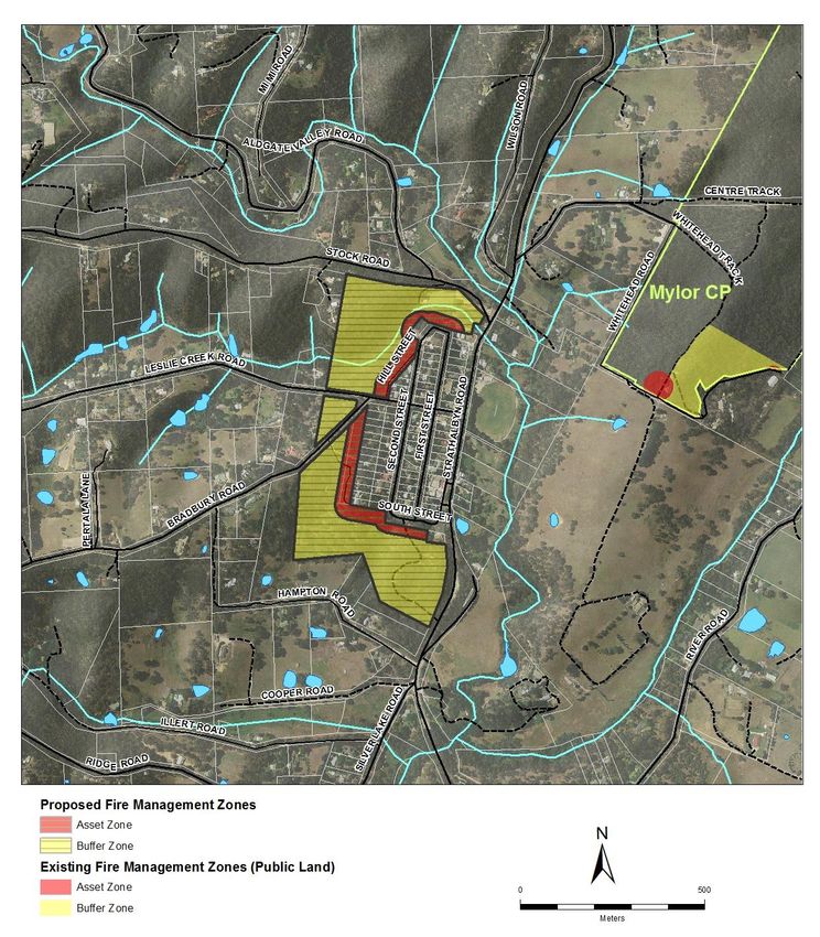
d. Use or establish principles and standards to guide or measure the success of the bushfire
         management strategies and initiatives.

The purpose of the AMLR BMAP is to provide strategic direction for bushfire management planning in the
AMLR Bushfire Management Area (BMA) (refer to location map on page 6), through the identification of
strategies for bushfire risk modification to selected assets and areas and across the landscape regardless of
tenure. The Plan will be used by State and Local Government land management organisations to guide the
development of bushfire management works plans for areas of land under their responsibility. Local
Government work plans will guide the establishment/development of bushfire mitigation works on private
lands. The Plan also provides essential inputs into State and Local Government planning, the application of
building codes, fire fuel management, planning for emergency management response, and prioritising of
resources for sound mitigation decisions.

Following an assessment of bushfire risks and the adequacy of current control measures within the AMLR,
additional risk treatment strategies have been determined that aims to improve the resilience of the wider
community and the assets identified in the plan.

The scope of the AMLR BMAP encompasses a range of asset categories and landscape wide areas of
potential bushfire risk. Asset categories include areas of human settlement; industrial and business areas;
and assets of cultural significance to local communities or the State. (See 4.1 Assets at Risk from Bushfire).
Selected areas of bushfire concern that relate to multiple assets or the movement of bushfire through the
broader landscape have been included and mapped as Landscape Treatment Investigation Areas. These
proposed areas of investigation require further assessment and consultation with stakeholders to
determine the most effective, acceptable and achievable vegetation management strategies to directly
reduce the intensity and movement of fire through the landscape and the impact of bushfire on a cluster
of assets.   Bushfire safety requires a partnership approach and is a shared responsibility between
government agencies, the private sector, non-government organisations, individuals and the wider
community. The planning process ensures consultation strategies provide all stakeholders with the
opportunity to contribute to fire management planning and thus undertake appropriate action to address
the risk of bushfire.

1.2 Objective
The protection of people, property and the environment is the fundamental objective of this plan, as a
shared responsibility between government and the community. Members of the community are required
to contribute to mitigating bushfire risk. The risk assessment process focuses predominantly on what can
be measured (vegetation, fire intensity, separation distances, weather, topography, building resilience,
access routes etc.) and what can be managed by applying risk treatment strategies.

The objective of this plan is to:
    a. Document the outcome of the AMLR BMC identification and assessment of the bushfire risk to
         assets within the AMLR BMA;
    b. Capture the current and future risk treatment strategies;

                                            ADELAIDE MOUNT LOFTY RANGES BUSHFIRE MANAGEMENT AREA PLAN            Page 2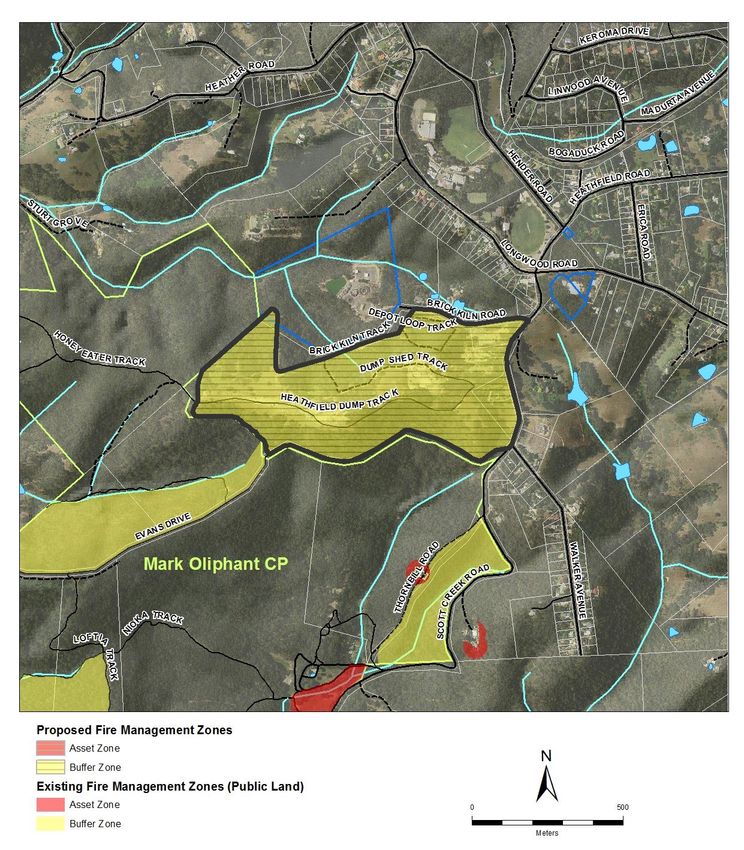
c.   Identify those asset or land custodians responsible for implementing risk treatment strategies to
         manage     the risks and reduce the community’s vulnerability to bushfire by improving
         preparedness utilising local knowledge, experience and expertise
    d. Support and inform planning at a local level; and
    e. Inform stakeholders of the potential bushfire risk within the AMLR BMA.

Assessment of the strategies to protect other assets within the AMLR BMA will need to be reviewed as the
strategies are implemented.

1.2.1 Constraints, Assumptions and Exclusions
It is not currently feasible to include and risk assess every parcel of land, building or area in the AMLR.
However, this does not mean that land, assets, communities or people who are not specifically identified
in the Plan’s online map by a point, polygon or line have no level of risk. Every landholder has a
responsibility to undertake bushfire prevention and preparedness activities relevant to their location and
situation.

Data on the location and nature of environmental assets has been collected however restricted
timeframes and resources have delayed the development of a risk assessment process and related
management strategies specific to environmental assets. Any identification and assessment of risk levels
and risk treatment strategies for environmental assets must include a determination of potential impacts
on significant species and ecological communities.          As a result, environmental assets and related
management strategies will be included in a subsequent update of this online AMLR BMAP following a
period of public consultation. This will include conservation and recreation parks and other areas people
visit for hiking and recreation. It is planned to have the completed environmental asset information
included by November 2016. (See Section 4.2.4 Environment)

The initial list of Landscape Treatment Investigation Areas (See Section 1.1 Purpose and Scope; Section
5.2.1; Landscape Treatment Investigation Areas Appendix 2; and Definitions and Acronyms) does not
represent an exhaustive or priority-based list of all potential Landscape Treatment Investigation Areas.
Additional areas will be included following further risk assessment, identification and consultation with
affected landowners. This includes identifying and assessing risk treatment strategies to determine their
impact on significant species and communities.

On the advice of the Department of the Premier and Cabinet – Aboriginal Affairs and Reconciliation
Division, to prevent damage, disturbance or interference with any Aboriginal site or object, assets of
Aboriginal cultural and spiritual significance will not be specifically identified in this iteration of the plan.
Further consultation with relevant stakeholders will be undertaken on the methodology for including
assets of Aboriginal significance in the Plan.

This AMLR BMAP does not include details for implementation, monitoring, review or reporting. These
requirements will be set out in the State Bushfire Management Plan and undertaken as part of the BMAP
implementation process.

                                           ADELAIDE MOUNT LOFTY RANGES BUSHFIRE MANAGEMENT AREA PLAN                Page 3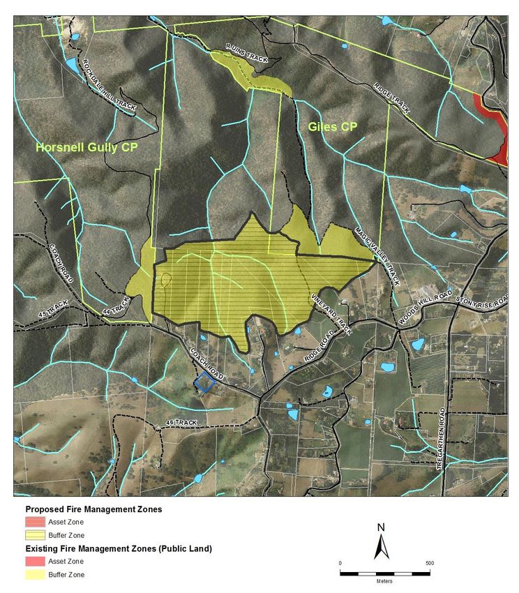
Weather conditions play a significant role in the likelihood of a bushfire occurring and its behaviour and
intensify, should it occur. As part of determining these calculations, risk assessments have been based on
inputs derived from Bureau of Meteorology (BOM) weather data over the fire danger season (October to
April) for the last 5-7 years for the fire ban districts in each bushfire management area throughout the
state.
Formulas and data used during risk assessment workshops and in the development of this plan have been
based on the best available information at the time of development, and may be subject to change over
time as more accurate data and information becomes available.
1.2.2 Considerations in developing the Bushfire Management Area Plan
The following considerations have been applied in the development of the BMAP:
Protection and preservation of life
Protection of critical infrastructure and community assets that support community resilience
Protection of residential property as a place of primary residence
Protection of assets supporting livelihoods, economic production and community financial
sustainability
Protection of cultural assets
Protection of Environmental and Conservation Assets
Compliance with relevant Acts, Codes of Practice and Regulations
1.3 Legislation
1.3.1 Fire and Emergency Services Act
A BMAP is a requirement under the FES Act 2005 Section 73A. In particular Section 73A(1) requires the
BMC to prepare and maintain a BMAP for its area. Section 73A(3) outlines that the BMAP must:
a. identify existing or potential risks to people and communities within its area from bushfire; and
b. outline strategies to achieve appropriate hazard reduction associated with bushfire management
within its area, especially through a coordinated and cooperative approach to bushfire prevention
and mitigation; and
c. identify action that should be taken by people, agencies and authorities to achieve appropriate
standards of bushfire management within its area; and
d. without limiting points (b) and (c), establish or adopt principles and standards to guide or measure
the successful implementation of bushfire management strategies and initiatives; and
e. include or address other matters prescribed by the regulations or specified by the SBCC.
The following Sections 73A(4) and 73A(5) direct that the BMAP must be consistent with the State Bushfire
Management Plan, and such other plans, policies and strategies as may be prescribed by the regulations.
1.3.2 Local Government Act
Section 7 of the Local Government Act 1999 specifies the principle functions of a Council. The functions
that are specific to this plan include:
ADELAIDE MOUNT LOFTY RANGES BUSHFIRE MANAGEMENT AREA PLAN Page 4 Section 7(d): to take measures to protect its area from natural and other hazards and to mitigate
the effect of such; and
Section 7(f): to provide infrastructure for its community and for development within its area
(including infrastructure that helps to protect any part of the local or broader community from
any hazard or other event, or that assists in the management of any area).
Additionally Section 8(d) of the Local Government Act 1999 outlines the way in which councils are required
to undertake their roles and functions. It specifies the need for consistency of all plans, policies and
strategies with Regional, State and National objectives and strategies concerning the economic, social,
physical and environmental development and management of the community.
1.3.3 State Emergency Management Act
Section 3 of the Emergency Management Act 2004 (South Australia) specifies that an “emergency means
an event (whether occurring in the State, outside the State or in and outside the State) that causes, or
threatens to cause:
a. The death of, or injury or other damage to the health of, any person; or
b. the destruction of, or damage to, any property; or
c. a disruption to essential services or to services usually enjoyed by the community; or
d. harm to the environment, or to flora or fauna
This is not limited to naturally occurring events (such as earthquakes, floods or storms) but would, for
example, include fires, explosions, accidents, epidemics, sieges, riots, acts of terrorism or other hostilities
directed by an enemy against Australia.”
At a regional level, this plan will provide valuable input into the Zone Emergency Management Plan (ZEMP)
in relation to rural fire.
1.3.4 Acts, Codes and Regulations Influencing Bushfire Management Planning
The following are some of the Acts, Codes and Regulations to be considered in developing and undertaking
bushfire management planning and practices:
Native Vegetation Act 1991 (SA) Section 29
Native Vegetation Regulations 2003 (SA) Section 5A-1 and 5(1)(zi)
Environment Protection and Biodiversity Conservation Act 1999 (Commonwealth) Section 18 and
269AA
Code of Practice for fire management on Public Land in South Australia 2012-2016
National Parks and Wildlife Act 1991 (SA)
Wilderness Protection Act 1991 (SA)
Crown Land Management Act 2009 (SA)
Development Act 1993 Development Regulations 2008
ADELAIDE MOUNT LOFTY RANGES BUSHFIRE MANAGEMENT AREA PLAN Page 52 ADELAIDE MOUNT LOFTY RANGES BUSHFIRE
MANAGEMENT AREA
2.1 Location
The AMLR BMAP has been developed for the AMLR BMA region of South Australia. The boundary
incorporates the whole of the following council areas: (see map below)
Adelaide Hills Council
The Barossa Council
City of Burnside
City of Campbelltown
The Town of Gawler
City of Marion
City of Mitcham
Mt Barker District Council
City of Onkaparinga
City of Playford
City of Salisbury
City of Tea Tree Gully
Figure 1: Adelaide Mount Lofty Bushfire Management Area
ADELAIDE MOUNT LOFTY RANGES BUSHFIRE MANAGEMENT AREA PLAN Page 62.2 Fire History
The following list contains examples of the years, locations and data of some fires relevant to the Adelaide
Mt Lofty Ranges BMA. It is not a definitive list of all fire occurrences within the BMA but provides a guide
on the frequency of fires.
Fire history has been considered as part of the risk assessment process.
1938 – 1939 Adelaide Hills
1943 – 1944 Adelaide Hills
1948 – 1949 Bridgewater, Mt Barker
1950 Mt Lofty
1951 Adelaide Hills, Woodside, Stirling, Lenswood
1955 Adelaide Hills – Black Sunday - 40,000ha, 2 firefighters, $4,000,000
1980 Adelaide Hills - Ash Wednesday I - 3,770ha, 50 homes
1983 Adelaide Hills – Ash Wednesday II - 12 deaths, 120 homes, historic buildings.
1985 Adelaide Hills
1987 Morialta – 300ha
1988 Kersbrook – 400ha
1995 Heathfield – 450ha
2000 Brownhill Creek – 1,000ha
2001 Hillbank – 350ha
2003 Morphett Vale – 300ha
2005 Mt Osmond - 120 ha, 3 buildings, 4 vehicles, 4 km fencing.
2007 Mt Bold - 2,000ha, numerous sheds, livestock and equipment fire damaged.
2014 Eden Valley - 25,000ha, 4 houses, multiple sheds, livestock, native fauna, 100s x km fencing
2015 Sampson Flat - 12 600ha, 24 houses, 103 sheds, 62 firefighter injuries, $13 million.
2.3 Topography
The Adelaide Hills rise from the eastern edge of the Adelaide Plain. The topography is generally rolling hills
with more severe gullies and creeks to the west and more undulating hills to the east and north. In the
northwest Hills Face Zone there are complex steep escarpments and gullies with reservoirs, pine
plantations and conservation areas with remnant vegetation. To the south is the Onkaparinga Valley with
rolling hills and less continuous vegetation than that in the Mount Lofty Ranges.
2.4 Water Catchments
Water catchments often comprise of large areas with multiple landowners and jurisdictions. SA Water
applies the following definitions to Mt Lofty Ranges catchment and watershed areas:
P1 - Priority 1 (P1) areas are the immediate hydrological catchments of the primary reservoirs
and streams that are directly harvested for drinking water supply, where the provision of the
highest quality public drinking water is fundamental.
P2 - Priority 2 (P2) areas are those within 2 km of secondary water supply reservoirs, land
within 100 metres of watercourses used to convey River Murray water into Hills reservoirs, and
ADELAIDE MOUNT LOFTY RANGES BUSHFIRE MANAGEMENT AREA PLAN Page 7land in flood-prone and high-runoff areas. P2 areas fall into an intermediate water quality risk
category.
P3 - Priority 3 (P3) areas include all remaining parts of the Watershed, including catchment
areas set aside for future reservoirs. In P3 areas it is acknowledged that water supply
catchment functions co-exist with agricultural, residential, commercial and industrial uses. P3
areas include the remainder of the catchment.
2.5 Land Tenure
Private ownership – residential and industrial/commercial and conservation including
Vegetation Heritage Agreements under the Native Vegetation Act 1991.
Council managed areas
SA Water
Forestry SA
Department of Environment, Water and Natural Resources (DEWNR)
Commonwealth and State Crown lands
Traditional owners
2.6 Land Use
The following list outlines some of the main types of land uses in the AMLR BMAP:
Agriculture
Viticulture
Commercial forestry
Conservation
Tourism
Industrial
Residential
Water courses, storage and catchments
The type of land use may influence a range of bushfire issues such as chances of ignitions, ability of
bushfire to establish and spread, opportunities for suppression and the risk treatments applied to reduce
bushfire risk and impact. Although there are multiple land uses and land owners across AMLR, broader
bushfire issues and risk treatments are assessed and applied using a tenure blind approach to bushfire
management planning.
ADELAIDE MOUNT LOFTY RANGES BUSHFIRE MANAGEMENT AREA PLAN Page 8Figure 2 below from the Bureau of Meteorology provides a colour coded map of land use across the AMLR
Figure 2: Land use in the Adelaide Mount Lofty Ranges
ADELAIDE MOUNT LOFTY RANGES BUSHFIRE MANAGEMENT AREA PLAN Page 92.7 Climate
2.7.1 Temperature
The temperature is typically Mediterranean in the southern coastal areas. This means hot dry summers
and wet mild winters are experienced. In summer the maximum temperature ranges between 24 - 35°C,
although on extreme days the temperature can reach >40°C. The average winter maximums range
between 16 - 18°C and the winter minimums tend to fall between 5 - 8°C.
2.7.2 The Impacts of Climate Change
Decreases in rainfall and higher evaporation rates will mean less soil moisture and less run off in rivers,
streams and reservoirs. Our demand for water may also increase as a result of warmer temperatures and
as our population grows, effectively increasing bushfire activity.
Changes in climate will have a range of impacts – for example on water resources, bushfire frequency and
intensity, primary production, infrastructure and the health of our landscapes. As well as the direct
environmental impacts of climate change there is also the interaction with other drivers of change such as
population growth in these areas.
2.7.3 Wind and Weather Patterns
During the summer a succession of high pressure systems track from west to east, usually five to seven
days apart. The centres of these high pressure systems generally pass to the south of Adelaide, producing
south easterly, easterly or north easterly winds. As these high pressure systems move to the east, the
wind direction turns north-east to northerly, often bringing a stream of dry and hot air across the AMLR
BMA. The region experiences thunderstorms and lightning in spring and summer that may be dry or wet
and cause gusty and variable winds from multiple directions.
A frequent summer weather pattern of great concern to firefighters and community is during the strong
northerly winds carrying hot dry air combined with a frontal change causing winds to swing around to
come from the west and/or become much stronger, unstable and gusty from several directions. When
fires start and become established under such conditions they may rapidly increase in size and may be
difficult to control. In certain conditions fires become uncontrollable, meaning that protection of life and
asset protection becomes the priority until conditions abate.
2.7.4 Rainfall
Rainfall is seasonal across the AMLR BMA with 40% of the total annual rainfall tending to occur in the
winter months compared with only 10% in the summer months. The majority of rain falls between May
and September. The amount of rainfall varies across the BMA and the annual average rainfall varies
between 700 – 1000mm.
ADELAIDE MOUNT LOFTY RANGES BUSHFIRE MANAGEMENT AREA PLAN Page 102.8 Fire Ban District and Bushfire Season
The AMLR BMA encompasses areas of both the Adelaide Metropolitan and Mt Lofty Ranges Fire Ban
Districts (FBD). Fire Danger Season (FDS) dates are set annually by the CFS Chief Officer based on
recommendations from the AMLR BMC.
Adelaide Metropolitan: These dates are generally from the 1st of December to the 30th April but may be
varied according to climatic influences leading up to and during the summer months.
Affects: Burnside, Campbelltown, Marion, Mitcham, Onkaparinga, Playford, Salisbury and Tea Tree Gully.
Mount Lofty Ranges: These dates are generally from the 1st of December to the 30th April but may be
varied according to climatic influences leading up to and during the summer months.
Affects: Adelaide Hills, Barossa, Burnside, Campbelltown, Gawler, Mitcham, Mt Barker, Onkaparinga,
Playford, Salisbury and Tea Tree Gully.
ADELAIDE MOUNT LOFTY RANGES BUSHFIRE MANAGEMENT AREA PLAN Page 11Figure 3: Adelaide Metropolitan and Mt Lofty Ranges Fire-Ban Districts Map
ADELAIDE MOUNT LOFTY RANGES BUSHFIRE MANAGEMENT AREA PLAN Page 122.9 Population
The AMLR BMA is one of the most densely populated rural fire regions in the state, with a population of
over 500,000 people. In most areas there has been rapid growth around central townships with
residential development now extending as far south in Metropolitan Adelaide as Pt Noarlunga and Seaford
Rise. Mt Barker has also experienced rapid growth due to the opening up of land for new development.
The Adelaide Mount Lofty Ranges continues to experience planned growth and population increases
within centres, townships and settlements notwithstanding boundaries around townships being in place
since the 1980s. The application of Environment and Food Production Areas through the new Planning,
Development and Infrastructure Act, 2016 potentially will serve to limit encroachment of residential
development within productive food growing areas.
More than 35 suburbs in Adelaide's fringes and more than 40 towns in the Adelaide Hills are in bushfire
prone areas.
ADELAIDE MOUNT LOFTY RANGES BUSHFIRE MANAGEMENT AREA PLAN Page 13Figure 4: Adelaide Mount Lofty Ranges Population Density
ADELAIDE MOUNT LOFTY RANGES BUSHFIRE MANAGEMENT AREA PLAN Page 143 ROLES AND RESPONSIBILTIES
3.1 State Bushfire Coordinating Committee
The FES Act 2005 Section 71A outlines the functions of the State Bushfire Coordination Committee. Some
of these functions include:
a. promoting the State-wide coordination and integration of policies, practices and strategies
relating to bushfire management activities;
b. providing guidance, direction and advice to bushfire management committees;
c. preparing and reviewing the State Bushfire Management Plan and to keep under review the
extent to which Bushfire Management Area Plans and strategies adopted or applied by bushfire
management committees are consistent with the State Bushfire Management Plan;
d. approving and auditing Bushfire Management Area Plans prepared and endorsed by Bushfire
Management Committees.
3.2 Adelaide Mount Lofty Ranges Bushfire Management Committee
The AMLR BMC has been established by the SBCC under the FES Act 2005, and under Section 73A(1) of this
Act must prepare and maintain a BMAP for its BMA. This plan takes an unbiased landscape view of the
strategic bushfire management needs of the BMA and is, therefore, boundary and tenure blind.
The key function of the AMLR BMC is to coordinate all relevant stakeholders with a responsibility for
bushfire management within the BMA, to undertake a risk assessment process, and oversee the
implementation of risk mitigation strategies. The purpose of this process is to reduce the risk of fire
negatively impacting on life, property, and the environment in accordance with the FES Act 2005. The role
and responsibility of AMLR BMC will include:
a. Promoting the coordination of policies, practices and strategies relating to bushfire management
activities within its area;
b. Preparing and keeping under review a BMAP for its area and ensuring that the BMAP is consistent
with the State Bushfire Management Plan;
c. Overseeing implementation of its BMAP and reporting to the SBCC;
d. Initiating or preparing the development of plans, policies, practices or strategies to promote
effective bushfire management within its area;
e. Convening with local or regional forums to discuss issues associated with bushfire management
within its area, including working with local communities to promote and improve effective
bushfire management;
f. In the exercising and performance of their powers and functions:
i. Having due regard to the impact of their actions on the environment; and
ii. Seeking to achieve a proper balance between bushfire prevention and proper land
management in the country; and
g. Performing any other functions assigned by the Minister or the SBCC.
ADELAIDE MOUNT LOFTY RANGES BUSHFIRE MANAGEMENT AREA PLAN Page 153.3 Bushfire Management Committee Member Organisations
BMC member organisations are responsible for:
a. Contributing to the decision-making of the Committee
b. Preparing and implementing action or work plans to address relevant risk treatments or issues
identified in the plan.
c. Ensuring input into the planning process by their BMC representatives
d. Providing information and make decisions on bushfire management planning issues within the
area
e. Reviewing the Bushfire Management Area Plan information and drafts and make amendments if
required
f. Determining methodologies for community and public consultation on key components of the
BMAP
g. Assessing and endorsing BMAP updates or changes.
Please refer to Appendix 3 for a list of the AMLR BMC member organisations.
3.4 Community
Bushfire prevention and preparedness is a shared responsibility of the State government, local councils
and fire agencies, individuals, landholders and building managers (public and private), and the broader
community. This BMAP assumes that all persons in the AMLR BMA are responsible for the mitigation of
the bushfire risk for themselves, their neighbours and their community, and therefore need to understand
and partake in bushfire prevention and preparedness. This is especially relevant to the protection of life
and the property and environmental assets not specifically identified by a point, polygon or line within this
BMAP.
In particular, legislation (FES Act 2005) states that owners of land must take reasonable steps to:
a) prevent or inhibit the outbreak of fire on the land; and
b) prevent or inhibit the spread of fire through the land; and
c) protect property on the land from fire; and
d) minimise the threat to human life from a fire on the land
To ensure that the community is observing these bushfire prevention and management activities, Local
Government Fire Prevention Officers within the AMLR BMA are required by the FES Act 2005 to assess the
extent of bushfire hazards within the council area, and provide advice to land holders and work with
communities on bushfire prevention and preparedness. Where necessary, Fire Prevention Officers can
enforce the provisions of the FES Act 2005 on private land.
Although conservation and recreation parks and other areas people visit for hiking and recreation have yet
to be included into this Plan, people visiting DEWNR managed parks need to recognise they are at risk
from bushfire. Several risk treatment measures are implemented by DEWNR with aim of reducing the risk
to life, such as signage and park closure policies on Total Fire Ban days.
ADELAIDE MOUNT LOFTY RANGES BUSHFIRE MANAGEMENT AREA PLAN Page 16Information relevant to all members of the community on bushfire prevention and preparedness can be
found on the following link: http://www.cfs.sa.gov.au/site/resources/fact_sheets.jsp
ADELAIDE MOUNT LOFTY RANGES BUSHFIRE MANAGEMENT AREA PLAN Page 174 RISK ASSESSMENT
Risk assessment is undertaken as assets are identified for inclusion into the online mapping and Risk
Register. The risk assessment process can be applied to cover the risks to structures, property and life
within built assets. A process for determining risk outcomes for environmental assets is being developed
and will be used to include environmental assets in the AMLR BMAP by November 2016.
The risk rating outcomes for assets currently identified in this Plan are determined using a number of
inputs (risk drivers). Some of these include:
Susceptibility of assets and people
Vegetation type and its distance from the asset
Predominant slope of the vegetation in relation to the asset
Access and/or egress to and from the asset
Frequency of ignitions in the general area of the asset
Risk drivers for each asset are contained in the extended version of the asset spreadsheet which is
available from the CFS Bushfire Management Planning Unit.
4.1 Assets at Risk from Bushfire
The range of assets identified and assessed for their risk from bushfire in this BMAP has been sourced
from local councils, infrastructure agencies, business groups, SA Government agencies, ALMR BMC
working groups, CFS, community groups and web based geospatial resources.
The life and property assets are geographically identified and presented with a coloured risk rating as
either, a point, line or polygon in the bushfire risk map that forms part of this plan. This plan also includes
a table listing all relevant information relating to the risks, as well as existing and proposed risk treatment
strategies associated with each asset. The planning process allows for a single repository for all current
and future assessments to be managed and maintained within the AMLR BMA.
The assets considered within this current plan are divided into four classes: Human Settlement, Economic,
Cultural Heritage and Environmental. Environmental assets will be added to the plan at a later date (See
section 1.2.1 Constraints, Assumptions and Exclusions). Each of these asset classes are further broken
down into asset categories as shown in Table 1.
ADELAIDE MOUNT LOFTY RANGES BUSHFIRE MANAGEMENT AREA PLAN Page 18Asset Class Asset Category
Residential
Human Settlement Special Fire Protection
Other
Infrastructure
Economic
Commercial or Industrial
Community
Cultural Heritage Historic
Other
Flora
Fauna
Environmental Ecological communities
(For more information see section 4.2.4
Environment)
Table 1: Asset Classes and Categories included in the Bushfire Management Area Plan
Human Settlement
Human Settlement assets are those assets which are likely to be occupied by people and may be at risk
from bushfire. Therefore, there is the potential for the loss of human life.
Economic
Economic assets considered within this plan are those of significance to the economy at all scales, and are
at risk from the impact of bushfire. They include commercial and industrial sites, and infrastructure
providing utilities such as energy, water, transport and telecommunications.
Cultural Heritage
Cultural heritage assets identified in this plan include those of significant cultural value, post 1836, when
non-Aboriginal people moved in to the Region. This category will also include assets that are of local
community value including halls, churches, institutes and recreational facilities.
Please see section 1.2.1 - Constraints, Assumptions and Exclusions regarding assets of Aboriginal cultural
and spiritual significance.
ADELAIDE MOUNT LOFTY RANGES BUSHFIRE MANAGEMENT AREA PLAN Page 19Environmental
The development of a risk assessment process and related management strategies specific to
environmental assets is still being undertaken by major stakeholders. (See section 1.2.1 - Constraints,
Assumptions and Exclusions, and Section 4.2.4 Environment). The environmental assets to be considered
for inclusion include flora, fauna, and ecological communities. Priority of assessment will be given to those
species and communities that have been given a rating in line with the Environmental Protection and
Biodiversity Conservation Act 1999 (Commonwealth), the National Parks and Wildlife Act 1972, or have
been identified in the DEWNR Regional Species Conservation Assessment Project (Gillam 2011). No risk
mitigation treatment should be undertaken in native vegetation until these environmental assets have
been identified through an environmental assessment process. Further information on this process is
included in Section 4.2.4 Bushfire Risk Assessment - Environment.
Assets and Areas not risk rated
Land, assets, communities or people who are not specifically identified in the online map of this BMAP by
a point, polygon or line may still have a level of bushfire risk. This is particularly relevant to the Adelaide
suburban/rural interface area and the more sparsely populated areas outside of the Adelaide suburban
area and rural townships. Landholders in the AMLR BMA, including people and asset owners not risk
rated, have a responsibility to undertake bushfire prevention and preparedness activities relevant to their
location and situation.
Urban Interface Area
There are large areas of the urban interface that are considered low risk from the direct impacts of a
bushfire. On the BMAP spatial plan, these are non-risk rated areas that are situated between the Bushfire
Safer Settlement line and risk rated human settlements. There are similar interface areas between some
of the Bushfire Safer Precincts and risk rated human settlements. Although these areas are low risk, they
may still be subject to smoke, spark and ember attack. People and asset owners in these areas still have a
responsibility to undertake bushfire prevention and preparedness activities relevant to their location and
situation.
Bushfire Safer Settlement and Bushfire Safer Precincts
Due to the expansion of Adelaide and AMLR townships, and as a result of this BMAP process, the
boundaries of the Bushfire Safer Settlement and Bushfire Safer Precincts will be reviewed and may be
expanded. This will result in a reassessment of interface areas in line with the new boundaries.
4.2 Bushfire Risk Assessment
Risk assessments analyse a potential hazard and consider both the likelihood and consequence of an event
occurring. These two factors combine to give an overall risk. For example an event that is unlikely to
happen and would have little consequence if it did happen would have a low risk; while an event that is
likely to happen and would have bad consequences would be a high risk.
In terms of expressing risk for life, property and the environment in the context of this plan, the following
aspects were used:
ADELAIDE MOUNT LOFTY RANGES BUSHFIRE MANAGEMENT AREA PLAN Page 20a. The likelihood of a bushfire igniting in the surrounding landscape and spreading to the vegetation
adjacent to the asset;
b. A bushfire event (flame, radiant heat and embers) directly igniting the asset or igniting the
vegetation immediately adjacent to an asset, resulting in an impact to the asset;
c. The consequence to the asset (loss or damage) from the bushfire event.
Figure 5: Bushfire Risk Diagram
4.2.1 Weather Context
When the bushfire risk assessment was undertaken for this plan, the weather conditions taken into
consideration were BOM weather data over the fire danger season period for the last 5-7 years for each
Fire Ban District. This is to enable the 99 percentile values to be utilised for the Bushfire Management
Area Planning in setting the weather context.
The required weather input for the risk assessment process includes:
Air temperature (°C)
Relative humidity (%)
Wind speed (Km/h) at a height of 10 metres
Drought factor (BOM)
Soil Dryness Index (SDI)
Through their local knowledge of fire weather and fire behaviour workshop attendees and other
stakeholders are able to determine which assets would be at risk and aid in the determination of likelihood
and impact of bushfire.
ADELAIDE MOUNT LOFTY RANGES BUSHFIRE MANAGEMENT AREA PLAN Page 214.2.2 Likelihood
In determining the likelihood of a bushfire igniting and spreading and impacting an asset the following
inputs are considered:
Australian Incident Reporting System (AIRS) data from SACFS for known ignitions to gain an
understanding of fires that have occurred.
Current land use data across the State to assist in determining vegetation layers and activities
associated with land use that could be potential ignition sources.
Historical evidence of past bushfires and scarring across the landscape.
The ability for fire to establish and spread and the density/type of vegetation within the
landscape. Inputs include Bureau of Meteorology data relating to local weather conditions within
the AMLR BMA, vegetation classification and fuel structures to undertake basic fire behaviour
modelling.
4.2.3 Consequence
The term “Consequence” for the purpose of this plan applies only to the asset itself. It means “what will
happen to the asset if it is impacted by a bushfire?” For example will it burn down, will it cease to
function, will people be injured etc.? It does not refer to the social, financial or business continuity
consequences of losing the asset. These will be considered in the implementation phase of the risk
treatments.
The elements that contribute to the consequence of a bushfire are the Bushfire Attack Level (BAL)
(measuring the radiant heat) and either the susceptibility of occupants in human settlement assets or
susceptibility of built structures.
Bushfire Attack Level (Radiant Heat)
Bushfire Attack Level (BAL) is a measure of the radiant heat a building or structure is expected to be
subjected to in the event of a bushfire on a day of Extreme FDR. This measure is used by the AS3959
Australian Standard for the construction of buildings in bushfire-prone areas in that buildings are rated to
certain BALs.
The BAL is determined by classifying the type of vegetation around the building, the distance of the
vegetation from the building, the slope of the land and the height of the most exposed part of the building
(typically the eaves). The higher the BAL, the higher the radiant heat will be at that site during a bushfire.
The aim should be to maintain assets below a BAL of 12.5 Kw/m2 thereby eliminating the ignition of the
structure from radiant heat. It should be noted that this Standard does not take into account the potential
impact of spark and ember on structures.
ADELAIDE MOUNT LOFTY RANGES BUSHFIRE MANAGEMENT AREA PLAN Page 22Figure 6: Bushfire Attack Levels
Susceptibility of Human Settlement Assets
This assessment refers to the susceptibility of the building occupants to bushfire and therefore, the
potential for the loss of human life. It is not the assessment of the structures or the built environment.
This assessment is based on the combination of three elements: the people who live in the area, the
preparedness level of the assets and environmental factors. For example, a rural community with a very
active Community Fire Safe Group, well prepared properties and a well maintained bushfire buffer zone
will have a reduced susceptibility.
Susceptibility of Built Structures (Economic and Cultural Heritage Assets)
The susceptibility of a built structure being adversely impacted by bushfire is dependent on the type of
construction and material used as well as its general condition. For example, concrete water tanks or steel
towers have a very low susceptibility, whereas a heritage timber barn would have a very high
susceptibility.
ADELAIDE MOUNT LOFTY RANGES BUSHFIRE MANAGEMENT AREA PLAN Page 234.2.4 Environment
The AMLR BMC and the SBCC acknowledge the importance of including environmental assets in bushfire
risk management. However, a formal process for the risk assessment of identified environmental assets
vulnerable to bushfire is not complete at the time of this plan’s initial release. The assessment process and
inclusion of environmental assets in the next iteration of this BMAP is scheduled for November 2016. Any
identification and assessment of risk levels and risk treatment strategies for environmental assets must
include a determination of potential impacts on significant species and ecological communities. Prior to
the addition of these assets and related information into the BMAP, a six week period of public
consultation will be undertaken to enable input and comment from interested organisations, groups and
individuals. (See section 1.2.1 Constraints, Assumptions and Inclusions). The process will include a review
of property asset risk treatments that may have environmental impacts in order to minimise these impacts
without compromising community safety.
Environmental assets are located throughout the BMA, and are not limited to formal protected areas.
While DEWNR Fire Management Plans provide strategic fire management direction for DEWNR-managed
lands and certain privately owned Vegetation Heritage Agreements, they do not consider all tenure types,
as required for BMAPs. DEWNR is currently developing a risk assessment process which will include
environmental assets on public and private land.
DEWNR develops risk-based Fire Management Plans that include strategies for bushfire risk mitigation and
suppression on DEWNR reserves and selected surrounding lands. The AMLR BMA incorporates lands
included within the following DEWNR fire management plans:
Hills Face Zone, Mount Lofty Ranges 2009-2019 (ref)
Onkaparinga Valley 2011-2021 (ref)
Southern Foothills, Mount Lofty Ranges 2009-2019 (ref); and
South Para Collaborative Fire Management Plan 2016-2026
The recommendations made within these DEWNR fire management plans are supported by the AMLR
BMC, and are included in the AMLR BMAP.
Environmental assets that will be considered in a subsequent risk assessment include:
Large areas of native vegetation – these areas are important for biodiversity conservation (e.g.
providing habitat), and may be made up of formally protected reserves, Crown lands, other lands
managed by government agencies, roadside vegetation, private protected areas (Vegetation
Heritage Agreements under the Native Vegetation Act 1991), and other private lands.
Native species and ecological communities of conservation significance. ‘Of conservation
significance’ is used to describe rated populations or species of flora and fauna as well as
vegetation communities. These may be:
o Nationally rated, that is, listed as Threatened (with a rating of Extinct, Critically
Endangered, Endangered or Vulnerable) under the federal Environment Protection and
Biodiversity Conservation Act 1999.
o South Australian rated, listed as Threatened (with a rating of Endangered, Vulnerable or
Rare) under the National Parks and Wildlife Act 1972, Schedules 7, 8 and 9.
ADELAIDE MOUNT LOFTY RANGES BUSHFIRE MANAGEMENT AREA PLAN Page 24o Provisionally listed as Threatened (with a rating of Endangered or Vulnerable) in South
Australia, that is, included on the unpublished DEWNR Provisional List of Threatened
Ecosystems of South Australia (Department of Environment and Heritage (DEH) 2005b).
Water catchment areas
Revegetation projects
Significant habitat elements (e.g. tree hollows)
Secondary risks to the environment (e.g. the environmental impacts caused by risk mitigation activities)
will also be considered, including:
Fire frequencies outside of Ecological Fire Management Guidelines
Introduction of threats or conditions favourable to abundant or pest species (e.g. weeds,
phytophthora, herbivores).
Further information for the management of natural resources in South Australia can be found on the
DEWNR website. The following links to Managing Natural Resources and to Fire Management provide a
range of information on stakeholders, responsibilities, strategies and actions in protecting and managing
natural resources and managing fire:
http://www.environment.sa.gov.au/managing-natural-resources
http://www.environment.sa.gov.au/firemanagement/Home
4.2.5 Risk Ratings
Table 2 below shows a standard risk rating matrix. It combines the likelihood and consequence scales
previously described to assign a level to each risk in terms of Low, Medium, High, Very High or Extreme.
This can be used as a guide in determining the level of urgency for allocating and implementing risk
treatment strategies. Although this method is very common, it is limited by only representing two
dimensions of the risk; the likelihood and consequence. Considerations also need to be given to the type
of asset being impacted by a bushfire, the level of risk that may be considered acceptable and whether the
desired risk level is achievable through current or proposed mitigation strategies. For example, a nursing
home rated moderate may be a much higher priority for risk treatments than a communication tower
rated as major.
Consequence
Minor Moderate Major Catastrophic
Almost Certain
Likelihood
Likely
Possible
Unlikely
Low Medium High Very High Extreme
Table 2: Overall Risk Rating Matrix
ADELAIDE MOUNT LOFTY RANGES BUSHFIRE MANAGEMENT AREA PLAN Page 255 RISK TREATMENT STRATEGIES
Bushfires cannot be eliminated from the landscape; however a combination of risk treatment strategies
can be applied to reduce either the likelihood and/or impact of bushfire and to increase community
resilience, enhance the ability of firefighting agencies to access and suppress bushfires, limit the spread of
bushfire, and protect people, assets and the environment.
Risk treatments are activities used to modify the characteristics of a hazard to reduce either the likelihood
and/or consequence of bushfire on an asset. The AMLR BMC will allocate mitigating risk treatment
strategies to reduce the risk to assets within the AMLR BMA. To facilitate this, the SBCC has endorsed risk
treatment strategies that include both asset specific and BMA wide risk treatments.
For a full list of all risk treatments strategies please refer to 5.3 Risk Treatment Strategies Suite.
5.1 Asset Specific Risk Treatment Strategies
Asset specific risk treatment strategies are allocated to mitigate individual risks within the BMAP Risk
Treatment Register and are designed to mitigate specific elements of the risk i.e. the radiant heat,
susceptibility of the asset to sparks and embers, the intensity of the bushfire and/or the potential of a
bushfire starting and establishing. Asset specific risk treatment strategies are allocated to asset owners
and/or land managers that are responsible and will assist in documenting in their work plans, details of
actions and timeframes.
Some examples of asset specific risk treatments include:
Property preparedness by ember proofing and clearing debris around a building
Asset Protection Zone (APZ) of modified vegetation in and around an electrical substation
Bushfire Buffer Zone (BBZ) of modified vegetation in a nature park immediately adjacent to a
nursing home
Bushfire Prevention Activities conducted by a Council Fire Prevention Officer such as issuing 105F
notices to landholders to remove high fuel hazard vegetation around a building.
For a copy of the list of specific risk treatments allocated to individual assets, please contact the CFS
BMPU.
5.2 Bushfire Management Area Wide Risk Treatment Strategies
BMA wide risk treatments are the overarching bushfire prevention and preparedness activities that are
applied to mitigate the occurrence, spread and consequence of bushfire to a number of assets, across
selected areas, or throughout the whole BMA.
They broadly address the bushfire risk to assets and, thereby, reduce the overall level of bushfire risk in
the BMA. Each of the risk treatment strategies will reduce either the likelihood and/or the consequence of
bushfire depending on the targeted outcome of the programme.
ADELAIDE MOUNT LOFTY RANGES BUSHFIRE MANAGEMENT AREA PLAN Page 26BMA wide risk treatments may include legislative requirements, policies and programs of firefighting
agencies, fuel hazard reduction, fire management planning, development and building regulations in fire
prone areas, arson prevention programmes, and community engagement and education about bushfires.
Some examples include:
National and State Legislation, Policies, Guidelines and Codes such as the South Australian Fire
and Emergency Services Act and Regulations 2005, that includes applicable fuel management
requirements, firebreak standards and annual enforcement programmes
State and local planning frameworks such as the State Bushfire Management Plan, Adelaide Mt
Lofty Ranges Bushfire Management Area Plan, local Council roadside vegetation management
strategies
DEWNR, SA Water and Forestry SA fire management policies and plans which sets out a range of
mitigation strategies to minimise the impact of bushfire on built and environmental assets
CFS state-wide preparedness campaigns, partnerships and community engagement programmes,
and management of Fire Danger Seasons, Fire Danger Ratings, Permits and Total Fire Bans
Department of Education and Childhood Development policies and procedures for schools at risk
from bushfires
Building Code of Australia and State based Minister’s Specifications
SA Police Operation Nomad
A significant and effective component of BMA wide risk treatments is the management of vegetation
(often referred to as “landscape risk treatments”). In response to the National Policy Statement for
Bushfire Management, and recent bushfire inquiries and recommendations, the South Australian
Government has mandated an increased programme of vegetation management and prescribed burning
to reduce bushfire consequences to life, property and the environment. Landscape risk treatments to
manage vegetation involve the use of prescribed burning, however where this may be undesirable or
operationally not practical, strategies such as the mechanical removal of vegetation may be undertaken.
Landscape risk treatments that form broader strategic breaks of low fuel across areas of the AMLR aim to
enhance suppression capability and therefore reduce the risk of fire moving between large or distinct
areas of high fuel such as Black Hill, Morialta, Cleland and Belair. Landscape risk treatments also aim to
reduce the risk of a bushfire impacting asset clusters such as townships or human settlement areas rather
than individual residences.
An excellent example of a landscape risk treatment is the Sheoak Road Strategic Fire Break. Situated on
the northern boundary of the Belair National Park, the City of Mitcham was assisted in developing a
strategic fire break along Sheoak Road by selectively thinning vegetation, controlling weeds, controlled
burns and extensive brush cutting. This fire break now reduces the possibility of fire spreading between
Belair National Park and Brownhill Creek/Eagle Mountain and provides safer access for the movement of
firefighting and other vehicles on hazardous fire days. This and other landscape risk treatment works are
ADELAIDE MOUNT LOFTY RANGES BUSHFIRE MANAGEMENT AREA PLAN Page 27You can also read