Part B: Appendix 3; Development Guidelines and Technical Standards; Section 6.5 of the Draft County Donegal Development Plan 2018-2024 - Donegal ...
←
→
Page content transcription
If your browser does not render page correctly, please read the page content below
Appropriate Assessment

                  Natura Impact Report

                                    of

     Part B: Appendix 3;
Development Guidelines and
Technical Standards; Section
   6.5 of the Draft County
 Donegal Development Plan
         2018-2024
 In Line with the requirements of Article 6 (3) of the EU Habitats Directive

                                                         April 2018
CONTENTS 1. INTRODUCTION......................................................................................................................... 3 2. APPROPRIATE ASSESSMENT ..................................................................................................... 5 Habitats Directive and Appropriate Assessment ................................................................................ 5 The Process of Appropriate Assessment ............................................................................................ 6 Stage 1 AA Screening of Part B: Appendix 3, Development Guidelines and Technical Standards, Section 6.5 ......................................................................................................................................... 8 Stage 2 Appropriate Assessment of Part B: Appendix 3, Development Guidelines and Technical Standards, Section 6.5........................................................................................................................ 8 3. COUNTY PROFILE .................................................................................................................... 10 4. Outline of Part B: App 3, Development Guidelines and Technical Standards, Section 6.5 ....... 12 5. RELEVANT NATURA 2000 SITES ............................................................................................... 15 Zone of Influence of Part B: Appendix 3, Section 6.5 of the Plan ...................................................... 15 Assessment of Likely Significant Affect ............................................................................................ 16 6. Appropriate Assessment of Part B: Appendix 3, Development Guidelines and Technical Standards, Section 6.5...................................................................................................................... 17 Summary Findings of Stage 2 Assessment ........................................................................................ 17 In Combination Effects ..................................................................................................................... 18 Mitigation Measures ........................................................................................................................ 18 7. Conclusion of Stage 2 – Appropriate Assessment & Natura Impact Report ............................. 20 Appropriate Assessment Conclusion Statement............................................................................... 20 8. Appendix 1. Natura 2000 Sites Relevant to this Appropriate Assessment .............................. 21 County Donegal: Special Areas of Conservation (SACs) ................................................................... 21 County Donegal: Special Protection Areas (SPAs) ............................................................................ 43 Northern Ireland SACs within 15km of County Donegal ................................................................... 58 Northern Ireland SPAs within 15km of County Donegal ................................................................... 70 County Sligo SACs within 15km of County Donegal .......................................................................... 72 County Sligo SPAs within 15km of County Donegal .......................................................................... 79 County Leitrim SACs within 15km of County Donegal ...................................................................... 82 County Leitrim SPAs within 15km of County Donegal ...................................................................... 88 EC Environmental Objectives (FPM) Regulations 2009 sites within the Donegal Area ...................... 89 9. Appendix 2. Impact Assessment Screening Matrix - Natura Impact Report ............................. 91 1
LIST OF TABLES
Table 1: Stages in the process of Habitats Directive Appropriate Assessment......................8
Table 2: Environmental Designations in Donegal.............................................................12

LIST OF MAPS
MAP 1: Natura 2000 sites within County Donegal in relation to windfarm development
areas............................................................................................................................16

2
1. INTRODUCTION
Donegal County Council is preparing a new County Donegal Development Plan 2018 – 2024
(hereinafter referred to as the Draft CDP). This will replace the existing County Donegal
Development Plan 2012 – 2018 (as varied). The Draft CDP is being prepared under the
provisions of the Planning and Development Act 2000 (as amended) to provide for
sustainable development and improvement of the environmental, social, economic and
cultural assets of the county.
It is the responsibility of the competent authority, Donegal County Council, to complete an
Appropriate Assessment (AA) in respect of the Draft CDP to assess the likelihood of the Plan
having significant affects on the integrity of the Natura 2000 network of European sites. The
Draft CDP, Environmental Report and Appropriate Assessment were published for a period of
public consultation from 19th May 2017 to 1st September 2017 inclusive. During the period of
public consultation of the Draft CDP, Environmental Report and Appropriate Assessment, a
total of 312 no. submissions/observations were made including 20 no. by prescribed
authorities, 275 no. by the general public, 8 no. by elected members and groupings of elected
members and a number of cross-directorate comments.
The Chief Executive’s Report, dated October 2017, summarised and responded to each of
these submissions/observations. Following consideration of this report, the Elected Members
at an adjourned Council meeting on 13th December 2017, proposed a number of changes to
the Draft Plan including 40 proposed Material Alterations and it was necessary to make them
available for public consultation, in compliance with the requirements of Section 12(7) of the
Planning and Development Act 2000 (as amended).
The review of the Draft County Donegal Development Plan 2018-2024 has been subject to an
Appropriate Assessment (AA) and a Strategic Environmental Assessment (SEA) throughout
the development plan process. An addendum to the SEA and the AA reports was prepared in
respect of the Material Alterations.
The proposed Material Alterations along with an environmental and appropriate assessment
of them were published for public consultation through the following three documents:
Proposed Material Alterations to the Draft County Donegal Development Plan 2018-2024
(including Appendix A), February 2018.
Strategic Environmental Assessment of Proposed Material Alterations to the Draft County
Donegal Development Plan 2018-2024: Addendum to Part D Environmental Report,
February 2018.
Addendum to Appropriate Assessment: Natura Impact Report of Proposed Material
Alterations to the Draft County Donegal Development Plan 2018-2024 (including
Appendices A-C), February 2018.
The proposed Material Alterations to the Draft CDP were made available for public
consultation during the period from 9th February 2018 to 8th March, 2018 inclusive, and
submissions and observations in respect of the Material Alterations were invited during this
time. A total of 32 no. submissions or observations have been received, 16 no. were received
from the public and 16 no. were received from Statutory Consultees.
In particular a submission from the Minister of the Department of Housing, Planning and
Local Government, (our reference PB12) was received on the 8th March 2018 pertaining to 5
different issues including Part B: Appendix 3; Development Guidelines and Technical
Standards, section 6.5(f) and raised the following points in relation to this section of the Draft
CDP:
The Department’s previous point (made in submission to Draft CDP on 31 st August)
that an SEA is required for Technical Standard 6.5 (f), being as it is a mandatory
3development management consideration thereby falling within the framework for
development consent set out in the CDP; this has not been assessed as part of the
SEA process.
The failure to submit this technical standard to an SEA renders the amended Draft
CDP inconsistent with the requirements of the Interim Planning Guidelines;
Renewable Energy and Climate Change, July 2017 (section 4) and not in compliance
with the SEA process in the Planning and Development Act 2000 (as amended),
section 1A, and the Planning and Development Regulations 2001 (as amended by
S.I.436/2004 and S.I.201/2011).
Highlights the requirements of Article 13A to 13F of the 2001 Regulations and
Schedule 2B that set out the relevant requirements.
The inclusion of the technical standard does not adhere to the procedures laid down
in the statutory obligations detailed above and it appears there is a serious breach of
statutory procedure.
Recommends the Council seek legal advice on how to remedy the points above but
suggests the clearest and most effective way to remedy the procedural failure would
be to remove technical standard 6.5 (f) to retain the integrity of the SEA report and
thereby the CDP.
Subsequent to the specific comments made in the submission from the Department of
Housing, Planning and Local Government referenced above this Natura Impact Report (NIR)
has been prepared in support of an Appropriate Assessment of Section 6.5 (sub-paragraphs
a-f) to fulfil the requirements of Council Directive 92/43/EEC of 21 May 1992 on the
conservation of natural habitats and of wild fauna and flora, hereinafter referred to as the
Habitats Directive. This report relates solely to Part B: Appendix 3, Development Guidelines
and Technical Standards, Section 6.5 and must be considered in the context of both
Appropriate Assessment Natura Impact Report of the Draft County Donegal Development
Plan 2018–2024 (May 2017) and NIR and Natura Impact Report of Proposed Material
Alterations to the Draft County Donegal Development Plan 2018-2024 (February 2018).
42. APPROPRIATE ASSESSMENT
Habitats Directive and Appropriate Assessment
The aim of the EU Habitats Directive (92/443/EEC) is to promote the maintenance of
biodiversity, taking account of economic, social, cultural and regional requirements. The
Directive recognizes that in the European territory of the Member States, natural habitats are
continuing to deteriorate and an increasing number of wild species are seriously threatened.
In order to ensure the restoration or maintenance of natural habitats and species of
Community interest at a favourable conservation status, it is necessary for Member States to
designate special areas of conservation in order to create a coherent European ecological
network. Criteria for site designation are set out in the Directive. The network of sites is
referred to as Natura 2000 and includes Special Areas of Conservation (SACs including
candidate SACs) and Special Protection Areas (SPAs including proposed SPAs).
The Natura 2000 network of European sites is comprised of sites of highest biodiversity
importance for rare and threatened habitats and species across the EU. SACs are selected
for the conservation of habitats listed in Annex I of the Habitats Directive, and for species of
animals (other than birds) and plants listed in Annex II. SPAs are selected for the
conservation of birds listed in Annex I of the Birds Directive (Directive 2009/147/EC of the
European Parliament and of the Council of 30 November 2009 on the conservation of wild
birds (codified version of Council Directive 79/409/EEC as amended)) and other regularly
occurring migratory birds and their habitats. The annexed habitats and species for which each
site has been selected are the qualifying interests of the sites, and the conservation
objectives of the site are based on these qualifying interests.
Crucially, the Habitats Directive requires that an AA must be made of any plan or programme
that is likely to have a significant effect on the conservation objectives of designated sites i.e.
on SACs or SPAs, before any decision can be made to allow that plan or project to proceed.
Article 6(3) of the Habitats Directive states that
“Any plan or project not directly connected with or necessary to the
management of the [Natura 2000] site but likely to have a significant effect
thereon, either individually or in combination with other plans or projects,
shall be subjected to an appropriate assessment of its implications for the
site in view of the site’s conservation objectives. In light of the conclusions
of the assessment of the implications for the site and subject to the
provisions of paragraph 4, the competent national authorities shall agree to
the plan or project only after having ascertained that it will not adversely
affect the integrity of the site concerned and, if appropriate, after having
obtained the opinion of the general public.”
In the event that an assessment determines that there is a likelihood of an adverse affect,
Article 6(4) makes provision for a plan or project to proceed under certain restricted
circumstances. Article 6(4) states that
“If, in spite of a negative assessment of the implications for the site and in
the absence of alternative solutions, a plan or project must nevertheless be
carried out for imperative reasons of overriding public interest, including
those of a social or economic nature, Member States shall take all
compensatory measures necessary to ensure that the overall coherence of
the Natura 2000 is protected. It shall inform the Commission of the
compensatory measures adopted.
Where the site concerned hosts a priority natural habitat type and/or a
priority species the only considerations which may be raised are those
relating to human health or public safety, to the beneficial consequences of
5primary importance for the environment or, further to an opinion from the
Commission, to other imperative reasons of overriding public interest.”
The application of AA in Ireland, as required by the Habitats Directive, is primarily governed
by the European Communities (Birds and Natural Habitats) Regulations 2011 (S.I. No. 477 of
2011 as amended by S.I. No. 355 of 2015), and the Planning and Development (Amendment)
Act 2010 (Part XAB), as amended by the Environment (Miscellaneous Provisions) Act 2011. A
range of guidance on carrying out appropriate assessment, and interpretation of relevant
legislation is available including inter alia
Appropriate Assessment of Plans and Projects in Ireland - Guidance for
Planning Authorities. Department of Environment, Heritage and Local
Government, 2009.
Managing Natura 2000 Sites: The Provision of Article 6 of the Habitats
Directive 92/43/EEC. European Commission, 2000.
Assessment of Plans and Projects Significantly Affecting Natura 2000 Sites:
Methodological Guidance on the Provisions of Article 6 (3) and (4) of the
Habitats Directive 92/43/EEC. European Commission, 2002.
Guidance Document on Article 6 (4) of the ‘Habitats Directive’ 92/43/EEC.
Clarification of the Concepts of Alternative Solutions, Imperative Reasons of
Overriding Public Interest, Compensatory Measures, Overall Coherence.
Opinion of the European Commission. European Commission, 2007 / 2012.
Nature and biodiversity cases: Ruling of the European Court of Justice.
European Commission. 2006.
Habitats Directive and environmental assessment of plans and projects .
García Ureta, A. Journal for European Environmental and Planning Law 2, 84-
96, 2007.
Appropriate Assessment under Article 6 of the Habitats Directive: Guidance
for Planning Authorities. Circular NPW 1/10 & PSSP 2/10.
Compliance Conditions in respect of Developments requiring (1)
Environmental Impact Assessment (EIA); or (2) having potential impacts on
Natura 2000 sites. Circular letter PD 2/07, NPWS 1/07
Compliance of Existing Land Use Plans with the EU Habitats Directive .
Department of Environment, Heritage and Local Government (2011) Circular
Letter PSSP 5/2011.
This Natura Impact Report (NIR) and the Appropriate Assessment process in general has
been guided by, and has taken account of the documentation outlined above.
The Process of Appropriate Assessment
While there is no prescribed method for undertaking Appropriate Assessment (AA), or form or
content for reporting, methodological guidance promotes a four-stage process to complete
the AA. The requirements for individual stages are summarized in Table 1. An important
aspect of the AA process is that the outcome at each successive stage determines whether a
further stage in the process is required. Stages 1 and 2 relate to Article 6(3) of the Habitats
Directive and are concerned with the strict protection of sites; stages 3 and 4 relate to Article
6(4) which is the procedure for allowing derogation from this strict protection in certain
restricted circumstances. Ultimately the plan may only be made if the AA process reaches
completion and has ascertained beyond reasonable scientific doubt that it shall not adversely
affect the integrity of a European site, or in the absence of alternative solutions, imperative
reasons of overriding public interest (IROPI) can be established as required under Section
177W, Part XAB, Planning and Development Act 2000 as amended. In the latter scenario
compensatory measures are required to offset any damage to the Natura 2000 network.
6Table 1. Stages in the Process of Habitats Directive Appropriate Assessment
Stage Task
1 Screening
Screening is the process that addresses and records the reasoning and
conclusions in relation to the first two tests of Article 6(3): i) whether a
plan or project is directly connected to or necessary for the management
of the site, and ii) whether a plan or project, alone or in combination with
other plans and projects, is likely to have significant effects on a Natura
2000 site in view of its conservation objectives. If the effects are deemed
to be significant, potentially significant, or uncertain, or if the screening
process becomes overly complicated, then the process must proceed to
Stage 2 (AA). Screening should be undertaken without the inclusion of
mitigation, unless potential impacts clearly can be avoided through the
modification or redesign of the plan or project, in which case the
screening process is repeated on the altered plan. The greatest level of
evidence and justification will be needed in circumstances when the
process ends at screening stage on grounds of no impact.
2 Appropriate Assessment
This stage considers whether the plan or project, alone or in combination
with other projects or plans, will have adverse effects on the integrity of a
Natura 2000 site, and includes any mitigation measures necessary to
avoid, reduce or offset negative effects. The proponent of the plan or
project will be required to submit a Natura Impact Report/Natura Impact
Statement, i.e. the report of a targeted professional scientific examination
of the plan or project and the relevant Natura 2000 sites, to identify and
characterize any possible implications for the site in view of the site’s
conservation objectives, taking account of in combination effects. This
should provide information to enable the competent authority to carry out
the appropriate assessment. If the assessment is negative, i.e. adverse
effects on the integrity of a site cannot be excluded, then the process
must proceed to Stage 4, or the plan or project should be abandoned.
3 Alternative Solutions
This stage examines any alternative solutions or options that could enable
the plan or project to proceed without adverse effects on the integrity of
a Natura 2000 site. The process must return to Stage 2 as alternatives
will require appropriate assessment in order to proceed. Demonstrating
that all reasonable alternatives have been considered and assessed, and
that the least damaging option has been selected, is necessary to
progress to Stage 4.
4 Imperative Reasons of Overriding Public Interest (IROPI)/Derogation
Stage 4 is the main derogation process of Article 6(4) which examines
whether there are imperative reasons of overriding public interest (IROPI)
for allowing a plan or project that will have adverse effects on the
integrity of a Natura 2000 site to proceed in cases where it has been
established that no less damaging alternative solution exists.
The extra protection measures for Annex I priority habitats come into
effect when making the IROPI case. Compensatory measures must be
proposed and assessed. The Commission must be informed of the
compensatory measures. Compensatory measures must be practical,
implementable, likely to succeed, proportionate and enforceable, and
they must be approved by the Minister.
7Stage 1 AA Screening of Part B: Appendix 3, Development
Guidelines and Technical Standards, Section 6.5
The Draft CDP has highlighted the significant number of protected species and habitats within
County Donegal, with Natura 2000 sites comprising approximately 18.5% of all land cover of
the County. The area of influence of Part B: Appendix 3, Section 6.5 is indicated in Figure
8.2.1 of the Draft Plan. It is distributed throughout the county and covers the greater part of
its extent. In light of this information, and exercising the precautionary principle, screening
of Part B: Appendix 3, Development Guidelines and Technical Standards, Section 6.5 for
potentially significant affects on Natura 2000 sites, either alone or in combination with other
projects or plans, in the context of the European sites' qualifying interests and possible
effects on the integrity of the Natura network cannot conclude beyond reasonable scientific
doubt that there will be no significant affects on Natura 2000 sites within the zone of
influence of Section 6.5.
It is therefore concluded that Part B: Appendix 3, Development Guidelines and Technical
Standards, Section 6.5 should proceed to Stage 2 Appropriate Assessment, including the
preparation of this NIR.
Stage 2 Appropriate Assessment of Part B: Appendix 3,
Development Guidelines and Technical Standards, Section 6.5
Stage 2 Appropriate Assessment will run concurrently with Strategic Environmental
Assessment (SEA) of Part B: Appendix 3, Development Guidelines and Technical Standards,
Section 6.5 in order that potential impacts can be re-examined throughout the process. The
scope of the stage 2 assessment has been informed by consultations with relevant statutory
authorities and in particular the submission received from the Minister of the Department of
Housing, Planning and Local Government, (our reference PB12). This NIR has taken account
of all submissions received.
The following sections of the NIR set out the information required to support an appropriate
assessment of Part B: Appendix 3, Development Guidelines and Technical Standards, Section
6.5 of the Draft CDP, and determine potential significant affects on the integrity of the Natura
2000 network. Such information is based on the best available scientific data. However, due
to the strategic nature of the Draft CDP and Part B: Appendix 3, Development Guidelines and
Technical Standards, Section 6.5, the potential for impact on Natura 2000 sites may be
uncertain, and therefore throughout the assessment the precautionary principle is applied.
The precautionary principle means, in essence, that action may be taken to protect against
risks to human health and/or the environment, even in the absence of conclusive scientific
evidence as to the existence, or extent, of those risks. Thus the onus is on the planning
authority, as the proponent of the plan, to demonstrate beyond reasonable doubt that
Technical Standards Section 6.5 of the Draft CDP will not give rise to significant adverse
affects, and that any avoidance/mitigation measures will work.
The information presented below is set out in a structured fashion as suggested in Guidance
for Planning Authorities. In summary, the sections that follow present:
County Profile - a description of the geographic area to which the plan
applies
Draft CDP 2018-2024 Part B: Appendix 3, Development Guidelines
and Technical Standards, Section 6.5 - Outline of Technical Standards
Section 6.5 and environmental implications
Natura 2000 Sites - Identification of relevant Natura sites, their
conservation objectives and threats to site integrity
8 Appropriate Assessment - A summary of impact assessment methodology
and its application to Part B: Appendix 3, Development Guidelines and
Technical Standards, Section 6.5
Cumulative and in Combination Effects - Assessment of effects in the
context of other regional or national plans or strategies
Mitigation Measures - An outline of any mitigation required to prevent
impacts on the Natura 2000 Network
93. COUNTY PROFILE County Donegal, covering an area of c.484,559.33ha, is the largest county in Ulster, and the fourth largest county in Ireland. It is located on the north western seaboard and is bounded on the southwest, west and north by the Atlantic Ocean, with an extensive indented coastline (approximately 1,132km). Located in the Border Region, County Donegal shares 93% of its entire land boundary with Northern Ireland (counties Derry, Tyrone, Fermanagh) and the remaining 7% (or 9km stretch) is with County Leitrim at its most southerly point. The County is therefore a key interface between the two jurisdictions and plays an important physical and cultural role in cross-border communications. The Census of Population 2016 preliminary results was published in July 2016. The town and country figures are due to be published in April 2017. Donegal's population is estimated at 158,755 in the 2016 census (CSO), a 1.5% decrease since 2011. The current figures for the 2011 census show that the county has a predominantly weak urban structure with a large number of small towns, with just 9 settlements falling into the aggregate urban area category of over 1,500 inhabitants. Letterkenny is the largest urban centre in Donegal with a population of 19,588. The county is thus predominantly rural in character with 33.8 persons per sq km compared to a State average of 67 persons per sq km. This is also reflected in the high numbers of households that are not connected to public sewers and that rely on on-site wastewater treatment. Approximately 38% of the land is in agricultural use, predominantly in the east of the county. Grass production and rough grazing for cattle and sheep are the main activities. Commercial forestry is also a significant land use in the county, and fishing is a significant employment sector. However with a peripheral location and a decline in traditional industries and services, Donegal is presented with many challenges as it looks to the future. Donegal is nationally recognized for the beauty of its landscape and coastline. The county is dominated by a mountainous spine with a complex geology consisting predominantly of granite and quartzite peaks running northeast to southwest. These are comprised of the Derryveagh range to the north, within which Glenveagh National Park is situated, and the Blue Stacks, extending from Ballybofey west to Gleann Cholm Cille (Glencolmcille) in the south. This has resulted in spectacular scenery in coastal locations such as Slieve League with sea cliffs rising to over 600m. The County also has a rich and distinctive cultural heritage. Eleven of Donegal’s coastal Islands were inhabited according to the 2011 census, and Donegal contains the second largest Gaeltacht in the country, with Gaeltacht areas distributed from Fanad Head on the north coast to Gleann Cholm Cille (Glencolmcille) in the south of the county. The Gaeltacht with its unique cultural, traditional and linguistic heritage occupies almost a third of the County. In addition to their cultural heritage, the islands also constitute a major natural resource, home to many protected bird and plant species. Oileán Thoraí (Tory Island), Inishbofin and Inishmeane are strongholds of the corncrake and Árainn Mhór (Aranmore) is home to Hart’s saxifrage, a subspecies unique to Ireland. The western seaboard also supports a diversity of other habitats including extensive dune systems, machair, dune scrub, salt marshes and wetlands. Lough Swilly is of major ornithological importance for wintering waterbirds with 18 species regularly occurring in nationally important numbers and three species in internationally important numbers. The county has many pristine rivers and lakes. These oligotrophic surface waters are home to rare and threatened animals including the freshwater pearl mussel, arctic charr, red throated diver and otter, and to rare aquatic plants such as the slender naiad. 10
Blanket bog is dominant over much of the higher land in the county. In addition to its
distinctive flora, it provides habitat for red deer, Irish hare, red grouse, golden plover, merlin,
peregrine falcon and more recently the golden eagle.

Table 2 lists the number of sites in Donegal with various environmental designations. While
the total number of designations indicates the resource value and high quality of the
environment in Donegal, this AA is concerned with the Natura 2000 designations i.e. SACs
and SPAs.

Table 2: Environmental Designations in Donegal

            DESIGNATION                                               NUMBER OF
                                                                        SITES
            Natural Heritage Areas (NHAs)                                 14
            Proposed NHAs                                                 78
            National Park                                                  1
            Ramsar Sites                                                   4
            Nature Reserves (officially designated)                        7
            Nature Reserves (un-designated)                                3
            Wildfowl Sanctuaries                                           6
            Biogenetic Reserves                                            1
            Refuges for Fauna                                              1
            Irish Geological Heritage Sites                              135
            Special Areas of Conservation (SACs)                          47
            Special Protection Areas (SPAs)                               26

11
4. Outline of Part B: App 3, Development Guidelines and
Technical Standards, Section 6.5
The energy strategy of the Draft CDP has been prepared in the context of the European and
national corporate policy frameworks as set out in: 'The EU Renewable Energy Directive,
2009' (EU); and the Department of Communications, Energy and Natural Resources' ‘Strategy
for Renewable Energy 2012-2020’, and White Paper entitled ‘Ireland's Transition to a Low
Carbon Energy Future, 2015-2030’. These documents set out a framework to guide energy
policy between now and 2030, with the aim of improving Ireland's renewable energy output
and reducing carbon emissions in accordance with the EU objective of a low carbon society
by 2050. It aims to facilitate the development of a diverse energy portfolio based on wind,
solar, hydro, wave, tidal, biomass, bio energy, oil and gas.
In keping with the policy frameworks, Donegal recognises the environmental benefits and
economic opportunities arising from the development of available renewable energy
resources, particularly wind, wave, tidal and hydro energy. County Donegal is ideally situated
on the North-West Atlantic coast to take advantage of its sources of renewable energies, and
the associated significant employment and economic opportunities arising as a result.
Notwithstanding this strategic context, the value of Donegal's natural, built and cultural
heritage must also be considered in the preparation of this policy framework. Renewable
energy proposals should be plan-led and focus in particular on:
Identification of the best sites for renewable energies and those sites for
protection.
Use the Landscape Character Assessment (LCA) to evaluate landscape types
(Donegal County Council completed its LCA in January, 2016 and this is a vital
tool in formulating wind energy policies).
Diversifying the renewable energy portfolio and enhancing the grid connections
to harness all forms of renewable energy.
Meeting the challenges of re-powering larger turbines on the sites of existing
turbines which are decommissioned upon reaching their end of life.
Donegal already generates significant wind energy outputs relative to other counties in
Ireland and has become an energy exporter, despite the limited available electricity grid
infrastructure in the County and significant environmental and heritage designations covering
over one-third of the County. It is therefore challenging to achieve a balanced approach to
the identification of further suitable locations that will not detract from the scenic and
environmental resource of the County.
The Council’s approach to wind energy has been prepared having regard to the Planning
Guidelines on Wind Energy Development, 2006 prepared by the (then) Department of the
Environment, Heritage and Local Government and has been augmented by the evidence base
made up inter alia by the landscape character assessment process, and the 'Windfarm
Development Guidance' report (June 2014) of the Donegal County Council Interreg IVa
project, 'Practical Implementation of Freshwater Pearl Mussel Measures'.
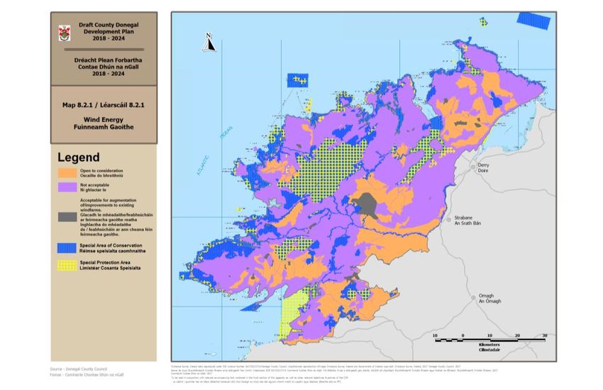
Arising from this process, and in accordance with E-P-12, Map 8.2.1 and 'Wind Energy'
section of Appendix 3, Development Guidelines and Technical Standards, Part B, Objectives
and Policies of the Plan, the Plan identifies the following policy/zoning areas for consideration
of proposed new wind farm developments, and alterations to existing wind farms within the
County.
(1) ‘Open to Consideration’: Within these locations, wind farm developments are open to
consideration, subject to compliance with other objectives and policies of the Plan. They
have been identified having regard to a range of factors, including natural heritage
designations and landscape sensitivity.
12(2) ‘Acceptable for augmentation of/improvements to existing windfarms’: Within these
locations, wind farm development would be unacceptable save as augmentation of, or
improvements to, existing wind farm development subject to compliance with all other
objectives and policies of the Plan.
(3) ‘Not acceptable’: Locations where Wind Farm Development would be unacceptable having
regard to their significant environmental, heritage and landscape constraints. These include;
Special Areas of Conservation (SAC's) and Special Protection Areas (Natura 2000) sites,
Natural Heritage Areas, areas of high and medium landscape sensitivity, Fresh Water Pearl
Mussel catchments.
Policies and objectives in relation to Energy, including wind energy, have been assessed in
the Appropriate Assessment Natura Impact Report of the Draft County Donegal Development
Plan 2018–2024. Where it has been required mitigation has been included to ensure
compliance with Article 6 of the Habitats Directive. This present assessment is specifically in
relation to Part B: Appendix 3, Section 6.5.
The relevant text in Part B: Appendix 3, Section 6.5 is cited below for ease of reference.
6.5 Wind turbines must meet the requirements and standards set out in the DEHLG
Wind Energy Development Guidelines 2006, or any subsequent related
Guidelines and in addition must not be located within:
(a) The zone of visual influence (ZVI) of the Glenveagh National Park.
(b) The zone of influence/flight path at Donegal Airport.
(c) Areas identified as locations where wind farm development would not be
acceptable as identified on map 8.2.1, chapter 8 of the County
Development Plan 2018-2024.
(d) Special Areas of Conservation (SACs) nor Special Protection Areas (SPAs)
(e) The 6 Fresh Water Pearl Mussel (S.I. 296 of 2009) catchments contained
in the Freshwater Pearl Mussel Sub-Basin Management Plans for Clady,
Eske, Glaskeelin, Leannan, Owencarrow and Owenea.
(f) A set back distance of ten times the tip height of proposed turbines from
residential properties and other centres of human habitation.
In relation to windfarm development Map 8.2.1 of the Draft CDP shows the areas within
County Donegal that are
acceptable for augmentation of/improvements to existing windfarms
not acceptable
open to consideration
The locations of SACs and SPAs (Appendix D), Feshwater Pearl Mussel catchments (Appendix
E), and the area of influence of Section 6.5 (f) in the case of 100m turbine tip heights
(Appendix F) are also shown.
Two associated definitions contained in Paragraph 6.6 are also relevant and copied below for
ease of reference:
6.6 Glenveagh National Park: Zone of Visual Influence
Definition:-
The environmental and visual character of Glenveagh National Park consists
of the geographic extent of the park and its immediate environs. The
implementation of the relevant policy should not be interpreted as relating to
lands with limited physical or visual connection to the park. The onus is on
the applicant to demonstrate the extent of the potential impact a proposed
wind energy development has on the National Park.
Centre of Human Habitation:
13Definition:-
'Centre of human habitation' includes schools, hospitals, churches, residential
buildings or buildings used for public assembly.'
145. RELEVANT NATURA 2000 SITES
Zone of Influence of Part B: Appendix 3, Section 6.5 of the Plan
For the purposes of AA, any Natura 2000 site within or adjacent to the plan or project area,
and any Natura 2000 site within the likely zone of impact of the plan or project are to be
included in the assessment. A distance of 15km is currently recommended as a minimum for
inclusion in the case of plans, but Natura 2000 sites that are more than 15km from the plan
must also be considered depending on the likely impacts of the plan or project, the
sensitivities of the ecological receptors, and the potential for in combination effects. In
considering relevant sites the precautionary principle must apply.
Relevant Natura 2000 sites in County Donegal and within a surrounding 15km buffer, or a
wider zone of influence where potential impact is considered possible, are tabulated in
Appendix 1. Datasets available on the National Parks and Wildlife Service website
(http://www.npws.ie) and on the Joint Nature Conservation Committee/Department of
Environment, Food and Rural Affairs website (http://jncc.defra.gov.uk) have been used to
identify sites, and to collate site specific information. The following information is included
for each Natura 2000 site:
• Site code
• Site name
• Qualifying interests
• Conservation objectives
• Threats to site integrity
At present there are 47 SAC’s and 26 SPA’s within, or partly within the County. A further 41
SACs and 12 SPAs within the zone of influence of the plan have been included. These Natura
2000 sites are shown in Map 1 below. More distant Natura sites are assessed on a case by
case basis and using the Source-Pathway-Receptor model to determine the potential for any
significant impact.
MAP 1: European sites within County Donegal in relation to windfarm
development areas
Source: Appendix F of the Draft Plan
15Assessment of Likely Significant Affect
The sub-paragraphs of Part B: Appendix 3, Section 6.5 are individually screened to assess for
likely significant affects on the Natura 2000 network. The assessment considers the
implications for relevant Natura 2000 sites, particularly in respect of their qualifying interests
and conservation objectives, and the integrity of the wider Natura network. Information on
current conservation status and threats to site integrity also form part of the assessment, and
possible in combination effects with other plans. When considering likely significant affects,
in situ and ex situ effects are assessed. The overall aim of the assessment is to predict
consequences that can reasonably be foreseen due to implementation of Part B: Appendix 3,
Section 6.5. It should be noted however that Section 6.5 is strategic in nature and the
impact assessment therefore reflects this in its generalised approach.
The overall aim of the Habitats Directive is to maintain or restore the favourable conservation
status of habitats and species of community interest in the Natura 2000 network. Favourable
conservation status is defined in generic terms as follows.
Favourable conservation status of a habitat is achieved when:
its natural range, and area it covers within that range, are stable or increasing, and
the specific structure and functions which are necessary for its long-term
maintenance exist and are likely to continue to exist for the foreseeable future, and
the conservation status of its typical species is favourable.
The favourable conservation status of a species is achieved when:
population dynamics data on the species concerned indicate that it is maintaining
itself on a long-term basis as a viable component of its natural habitats, and
the natural range of the species is neither being reduced nor is likely to be reduced
for the foreseeable future, and
there is, and will probably continue to be, a sufficiently large habitat to maintain its
populations on a long-term basis.
For many sites in the Natura network, site-specific conservation objectives have been set and
these are available on www.npws.ie. In the absence of site-specific objectives and targets
the generic objectives above apply. Since targets for attributes may change as more
information becomes available, it is essential that the date and version of conservation
objectives are cited. An appropriate assessment based on conservation objectives will remain
valid even if the targets are subsequently updated, providing they were the most recent
objectives available when the assessment was carried out.
Guidance sets out direct and indirect types of impacts that are to be considered in the
assessment process. These impacts include loss of habitat area, fragmentation of habitats,
disturbance of species, changes to population structure or density, and changes in quantity or
quality of the water resource. The potential for such impacts arises from many policy areas
including energy strategies, and infrastructural development including wind farms. These
activities can give rise to land take through development of natural sites; loss of staging sites
important to species migration or recruitment; habitat degradation through pollution or
resource depletion; species disturbance or disruption of food chains. Guidance documents
also provide indicators for assessing the significance of any impact.
Environmental pressures may arise from infrastructural developments; expansion of
sustainable or alternative energy sources and transmission networks; increased eco-tourism
and recreational activity. All of these pressures could potentially give rise to significant
effects on the Natura network and require careful management and mitigation if necessary.
Where likely significant affects are identified, alternatives to the relevant policy or objective
(including rejection) are considered that would avoid any impact, or mitigation measures are
formulated to offset any likely impact.
166. Appropriate Assessment of Part B: Appendix 3,
Development Guidelines and Technical Standards,
Section 6.5
The screening assessment is set out in Appendix 2. It sets out the subparagraphs of Part B:
Appendix 3, Section 6.5 of the Draft Plan and the Natura 2000 sites that could be affected;
the nature of any potential impacts, including in combination affects; an assessment of the
significance of any effect; and where appropriate the mitigation required to avoid impact.
The findings of this assessment process are outlined in Summary Findings of Stage 2
Assessment below. The scope of this assessment is to consider implications at the strategic
level of Section 6.5, the main goal of which is to direct windfarm development to suitable
locations, and restrict windfarm development at specified locations.
Summary Findings of Stage 2 Assessment
Part B: Appendix 3, Section 6.5 seeks to identify areas appropriate for windfarm development
and restrict development in areas considered unsuitable. Preventing development in these
areas, in particular remote upland areas, is likely to have beneficial or neutral environmental
effects. The Development Guidelines and Technical Standards in Section 6.5 are likely to
prevent impacts that may arise through:
land take for pylons and associated infrastructure
drainage and changes to local hydrology
Noise pollution and potential behavioural/feeding disturbance
distrubance due to operation of turbines and potential bird impact
distrubance due to construction and maintenance activity
distrubance due to secondary pressures such as recreational use associated with
enhanced access routes
Increased erosional losses to surface waters due to enanced drainage connectivity.
The Draft CDP has been subjectied to an Appropriate Assessment. The plan recognizes the
European and National value of the Natura 2000 network, and also the need to protect the
habitats of important species in the wider countryside outside designated areas. The aim of
the Natural Heritage strategy of the Draft CDP is to conserve, protect and manage the
County’s natural heritage for future generations and encourage appreciation and enjoyment
of these resources. It sets out the role of Article 6 of the Habitats Directive (92/43/EEC) in
requiring the protection of the designated species and habitats of European sites, and
explicitly states that any plan or project with the potential to impact on the conservation
objectives of designated sites is required to take appropriate steps to avoid the deterioration
of natural habitats and the habitats of species as well as significant disturbance of species for
which areas have been designated and will be subject to Appropriate Assessment. The
requirement to comply with Article 6 of the Habitats Directive is an explicit objective of the
Natural Heritage strategy.
The Draft CDP has also incorporated significant environmental mitigation measures in the
form of proactive objectives and policies. These reflect the consideration given to potential
environmental impacts throughout the iterative process of plan development which has
guided the formulation and environmental assessment of all policies and objectives. They are
relevant to mitigation of any potential environmental impact of Part B: Appendix 3,
Development Guidelines and Technical Standards, Section 6.5.
In relation to 'Part B: Appendix 3, Development Guidelines and Technical Standards, Section
6.5', this NIR finds that potential significant adverse affects are unlikely.
17In Combination Effects Where a plan or project is likely to have a significant effect on a European site, either alone or in combination with other plans or projects it is subject to AA. The in combination test should include completed, approved but uncompleted, or proposed (but not yet approved) plans or projects if sufficient detail is available for assessment. The consideration of cumulative effects includes the sum total of influences affecting the condition of Natura sites. Cumulative effects are perhaps most obvious in the case of space crowding of activities that taken in isolation would be sub-threshold in terms of significance in affecting Natura sites. However, long delays between cause and effect can result in time lags for in combination effects to materialise in some instances (e.g. changes in flow regimes due to forestry or drainage). Some in combination effects may be synergistic (e.g. lower flows combined with increased pollutant loads). Other effects can be secondary in nature (e.g. windfarm road access resulting in recreational disturbance of previously inaccessible areas). In all cases a precautionary approach is taken in the assessment. In combination effects are considered and set out in Appendix 2 for each element of Part B: Appendix 3, Development Guidelines and Technical Standards, Section 6.5. Relevant plans that could contribute to in combination effects in conjunction with the Draft CDP have been detailed and assessed in Appropriate Assessment Natura Impact Report of the Draft County Donegal Development Plan 2018–2024 (May 2017). Given that Part B: Appendix 3, Development Guidelines and Technical Standards, Section 6.5 relate to significant reduction in the potential development of windfarms in identified locations, it is likely to have a positive affect in reducing potential in-combination impacts. However, it is also clear from a review of the policies and objectives of the Draft CDP that there are sufficient safeguards (additional policies and mitigation) in place to ensure that there will not be any significant in-combination affects on the Natura 2000 network. Mitigation Measures Sustainable development while protecting and enhancing the environment are core tenets of the Draft CDP and these aims have informed the formulation of policies and objectives in all policy areas from the outset of plan preparation. In line with policy frameworks, proposed windfarm development is directed to robust receiving environments with sufficient capacity to absorb such development. This is in keeping with the principle of avoidance of negative effects in the first instance. The drafting and redrafting of policies and objectives in an iterative process that considers the environment and Natura 2000 sites at each stage is the primary method of mitigating adverse effects on European sites. Where potential significant adverse effects are deemed possible, alternative or revised policies and objectives are considered. Where necessary, additional policies or objectives have been drafted as mitigating measures to prevent possible impact on Natura sites and to ensure compliance with the requirements of Article 6 of the Habitats Directive. Many objectives and policies in the Draft CDP specifically require compliance with Article 6 of the Habitats Directive, or impose constraints of no impact on Natura 2000 sites. A suite of objectives and policies dealing with natural heritage (NH-O-1 to NH-O-11 and NH- P-1 to NH-P-5, NH-P-10 and NH-P-18) provide explicit and strong protection for terrestrial, aquatic, water-dependent, and marine habitats and ecosystems. In particular they provide for protection of the Natura network of sites through compliance with Article 6 of the Habitats Directive, but also for conservation of a wider spectrum of habitats and species of significance 18
in order to maintain biodiversity in general. Implementation of these objectives and policies
will be critical for protection of SACs, SPAs, NHAs, pNHAs and RAMSAR sites, WFD Protected
Areas, sites of high environmental status and for protection of species identified in the
Wildlife Acts and Flora Protection Order.

Objectives WES-O-4, WES-O-5, WES-O-6, and WES-O-7, and policies WES-P-4, WES-P-5, and
WES-P-8 also provide for environmental protection. In particular they ensure that surface
and groundwaters will be protected through implementation of the relevant River Basin
Management Plan (RBMP) and Programme of Measures, and that water quality will be
maintained, protected and enhanced.

Some 27 of the objectives and policies set out in the Draft CDP specifically include compliance
with Article 6 of the Habitats Directive as a condition of implementation. A further 10
objectives or policies impose a constraint of no impact on Natura 2000 sites. In addition
wider environmental constraints are referenced throughout many of the objectives and
policies of the Draft CDP, including compliance with RBMPs and Programmes of Measures,
Freshwater Pearl Mussel Sub-Basin Plans, Shellfish Pollution Reduction Programmes, and EU
Biodiversity Strategy.

Mitigating policies clearly indicate that where any physical development, including windfarm
development, has the potential to significantly impact on a Natura 2000 site, it will be subject
to an individual AA process, as defined by Article 6(3) and (4) of the Habitats Directive.
Where it is found that the plan or project has the potential to directly or indirectly impact on
the integrity of a Natura 2000 site, the appropriate mitigation will be through avoidance. If
avoidance is not possible, mitigation in the form of alternatives to the proposed plan or
project must be sought. In considering alternative solutions the plan recognizes that the
conservation objectives and status of the Natura 2000 site will outweigh any considerations of
cost, delays or other aspects of an alternative solution. The planning authority shall not,
therefore, limit its consideration of alternative solutions to those suggested by the project or
plan proponents. It is the member state’s responsibility to consider alternative solutions,
which could be located within different areas.

The Draft CDP therefore contains substantial environmental mitigation measures in proactive
objectives and policies. Account has been taken of the potential for environmental impact
throughout the iterative process of plan development and this has guided the drafting of
policies and objectives. Mitigation arising from Stage 2 Appropriate Assessment of the Draft
CDP is detailed in Appropriate Assessment Natura Impact Report of the Draft County Donegal
Development Plan 2018–2024 (May 2017).

Therefore in the context of the Draft CDP, there is sufficient mitigation in place to ensure
there will be no significant in situ or ex situ effects on the Natura 2000 network as a result of
the implementation of Part B: Appendix 3, Development Guidelines and Technical Standards,
Section 6.5.

19
7. Conclusion of Stage 2 – Appropriate Assessment &
   Natura Impact Report

This Appropriate Assessment has been carried out on Part B: Appendix 3, Development
Guidelines and Technical Standards, Section 6.5 of the Draft County Donegal Development
Plan for 2018-2024. Preparation of the assessment was undertaken using experienced
ecological expertise to identify any risks of significant adverse effects on the Natura network
of European sites. A review of conservation objectives, qualifying interests and threats to site
integrity for relevant Natura 2000 sites in the County and within the zone of influence of Part
B: Appendix 3, Development Guidelines and Technical Standards, Section 6.5 was undertaken
to identify sites that might be impacted by these Development Guidelines and Technical
Standards of the Draft Plan. Cumulative and in-combination effects were also considered.

Therefore considering Part B: Appendix 3, Development Guidelines and Technical Standards,
Section 6.5 of the Draft CDP and the mitigation measures included, it was found that no
direct, indirect or cumulative significant effects on Natura 2000 sites were likely.

Appropriate Assessment Conclusion Statement
This Appropriate Assessment Natura Impact Report of Part B: Appendix 3; Development
Guidelines and Technical Standards; Section 6.5 of the Draft County Donegal Development
Plan 2018-2024 concludes a Finding of No Significant Effects following the completion of
stage 2 of the process. Any potential impact on the Natura 2000 network has been mitigated
against through policies and objectives contained in the Draft County Donegal Development
Plan 2018-2024. As a result, there is no requirement to proceed to stage 3 of the AA
Process.

This assessment should be read in conjunction with the Draft County Donegal Development
Plan 2018-2024, the Appropriate Assessment Natura Impact Report of the Draft County
Donegal Development Plan 2018–2024 (May 2017), the Natura Impact Report of Proposed
Material Alterations to the Draft County Donegal Development Plan 2018-2024 (February
2018) and the accompanying SEA Environmental Report of Part B: Appendix 3; Development
Guidelines and Technical Standards; Section 6.5 of the Draft County Donegal Development
Plan 2018-2024 prepared in compliance with the requirements of the SEA Directive.

20
Draft County Donegal Development Plan
                                                                                                                                             2018-2024

8. Appendix 1. Natura 2000 Sites Relevant to this Appropriate Assessment

County Donegal: Special Areas of Conservation (SACs)
Site    Site name      Qualifying interests                       Conservation objectives                         Threats to site integrity
code
111     Aran Island   1230 Vegetated sea cliffs of the Atlantic   To maintain or restore the favourable           Changes in local hydrology including drainage;
        (Donegal)     and Baltic coasts                           conservation condition of the Qualifying        peat extraction; overgrazing; forestry;
        Cliffs        4030 European dry heaths                    Interests for which the SAC has been            burning; direct loss of habitat to development;
                      4060 Alpine and Boreal heaths               selected which are defined by the list of       arterial drainage/water abstraction/lowering of
                      8210 Calcareous rocky slopes with           attributes and targets in the site-specific     the regional water table; agricultural
                      chasmophytic vegetation                     conservation objectives (NPWS (2016)            reclamation. Introduction of alien invasive
                      8220 Siliceous rocky slopes with            Conservation Objectives: Aran Island            species. Illegal Dumping. Quarrying/removal
                      chasmophytic vegetation                     (Donegal) Cliffs SAC 000111. Version 1.         of sand. Aquaculture.; leisure fishing.
                      8330 Submerged or partially submerged       National Parks and Wildlife Service,            Outdoor sports and leisure activities,
                      sea caves                                   Department of Arts, Heritage, Regional,         recreational activities; urbanised areas, human
                                                                  Rural and Gaeltacht Affairs), and in relevant   habitation; utility and service lines
                                                                  supporting documentation.

                                                                  To maintain the extent, species richness and
                                                                  biodiversity of the entire site. To establish
                                                                  effective liaison and co-operation with
                                                                  landowners, legal users and relevant
                                                                  authorities.
115    Ballintra       4030 European dry heaths                   To maintain or restore the favourable           Changes in local hydrology including drainage;
                       8240 Limestone pavements*                  conservation condition of the Annex I           peat extraction; overgrazing; forestry;
                                                                  habitat(s) and/or the Annex II species for      burning; direct loss of habitat to development;
                                                                  which the SAC has been selected (NPWS           arterial drainage/water abstraction/lowering of
                                                                  (2016) Conservation objectives for Ballintra    the regional water table; agricultural
                                                                  SAC [000115]. Generic Version 5.0.              reclamation; agricultural improvements;
                                                                  Department of Arts, Heritage, Regional,         agricultural abandonment; under grazing;
                                                                  Rural and Gaeltacht Affairs).                   quarrying on esker ridges and limestone

21
You can also read