JP ALLOCATION 27 EAST OF BOOTHSTOWN TOPIC PAPER PFE 2021
←
→
Page content transcription
If your browser does not render page correctly, please read the page content below
JP Allocation 27
East of Boothstown
   Topic Paper
     PfE 2021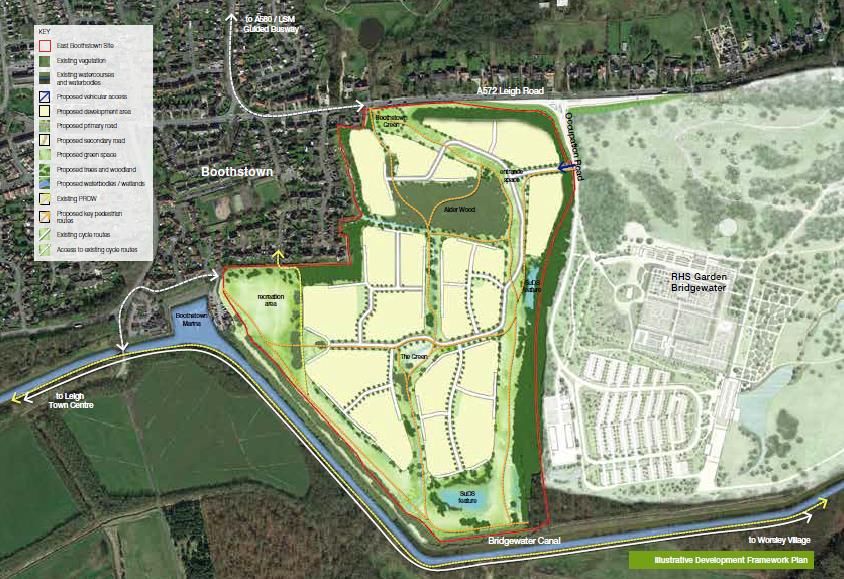
Contents

 Section A – Background .....................................................................................................4
            Introduction ...........................................................................................................5
            Allocation JP27 [East of Boothstown] Overview ....................................................7
            Site Details ............................................................................................................7
            Proposed Development .........................................................................................8
            Site Selection ...................................................................................................... 10
            Planning History .................................................................................................. 11
            GMSF 2019 Consultation Responses ................................................................. 11
            GMSF 2019 Integrated Assessment ................................................................... 12
            GMSF 2020 Integrated Assessment ................................................................... 12
 Section B – Physical......................................................................................................... 22
            Transport ............................................................................................................. 22
            Flood Risk and Drainage ..................................................................................... 25
            Ground Conditions .............................................................................................. 26
            Utilities................................................................................................................. 27
 Section C – Environmental ............................................................................................... 29
            Green Belt Assessment....................................................................................... 29
            Green Infrastructure ............................................................................................ 42
            Recreation ........................................................................................................... 43
            Landscape........................................................................................................... 44
            Ecological/Biodiversity Assessment .................................................................... 45
            Habitat Regulation Assessment .......................................................................... 46
            Historic Environment Assessment ....................................................................... 47
            Air Quality............................................................................................................ 48
            Noise ................................................................................................................... 50
 Section D – Social ............................................................................................................ 51
            Education ............................................................................................................ 51
            Health .................................................................................................................. 52
 Section E – Deliverability .................................................................................................. 54
            Viability ................................................................................................................ 54
            Phasing ............................................................................................................... 54
            Indicative Masterplanning.................................................................................... 55
 Section F – Conclusion .................................................................................................... 57

             Site Allocation Topic Paper – PfE 2021 – JPA27 East of Boothstown
                                                                                                                                   2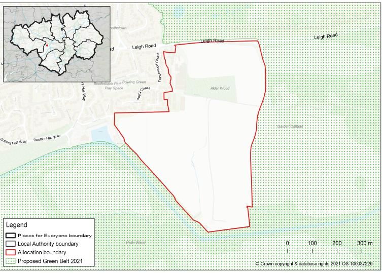
The Sustainability Appraisal ................................................................................ 57
           The main changes to the Proposed Allocation .................................................... 57
           Conclusion .......................................................................................................... 58
Section G – Appendices ................................................................................................... 60
Section H – Bibliography .................................................................................................. 63

            Site Allocation Topic Paper – PfE 2021 – JPA27 East of Boothstown
                                                                                                                             3
Section A – Background
This topic paper takes into account a wide-range of evidence published in support
of Places for Everyone, including work commissioned by the Greater Manchester
Combined Authority (GMCA) / districts such as: an integrated assessment which
incorporates the requirements to undertake a Sustainability Appraisal / Strategic
Environmental Assessment; financial viability assessments of the allocations; flood
risk assessments; transport locality assessments; and various assessments
relating to the Green Belt. A number of other documents have also been produced
in support of the allocation by the city council, whilst regard has further been had
to representations received to previous versions of the plan and also discussions
with statutory consultees. The findings of these documents, representations and
discussion are taken into account in this topic paper.

In addition to the above, the following technical assessments have been produced on
behalf of the majority landowner in support of the site allocation which they are promoting:

   •   Agricultural Land Quality (RAC – November 2019)
   •   Baseline Air Quality Assessment (Air Quality Consultants – March 2019)
   •   Ecological Representation (TEP - March 2019)
   •   Education Briefing Note (EFM – March 2019)
   •   Flood Risk Letter (WSP – July 2020)
   •   High level Archaeological Assessment (Peel – no specified date)
   •   Initial Heritage Appraisal (Turley – April 2020)
   •   Site Appraisal – Flood Risk (WSP – March 2019)
   •   Transport Statement (TTHC – March 2019)

These documents are not formally endorsed by Salford City Council or the GMCA at this
stage, but rather published for information as key pieces of technical work undertaken on
behalf of the majority landowner of the site. It is considered helpful to publish these
documents at this stage, so that people have as much information as possible in making
their comments on Places for Everyone 2021 (‘PfE 2021’). The conclusions drawn in these

           Site Allocation Topic Paper – PfE 2021 – JPA27 East of Boothstown
                                                                                          4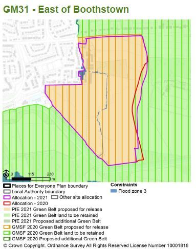
reports are outlined for information, where relevant, in this topic paper, and have informed
the allocation policy where appropriate.

All documents associated with Places for Everyone are available on the GMCA website

      Introduction

1.1   In November 2014, the AGMA Executive Board recommended to the 10 Greater
      Manchester local authorities that they agree to prepare a joint Development Plan
      Document (“Joint DPD”), called the Greater Manchester Spatial Framework
      (“GMSF”) and that AGMA be appointed by the 10 authorities to prepare the GMSF
      on their behalf.

1.2   The first draft of the GMSF DPD was published for consultation on 31 October 2016,
      ending on 16 January 2017. Following substantial re-drafting, a further consultation
      on the Revised Draft GMSF took place between January and March 2019.

1.3   On 30 October 2020, the AGMA Executive Board unanimously agreed to
      recommend GMSF 2020 to the 10 Greater Manchester Councils for approval for
      consultation at their Executives/Cabinets, and approval for submission to the
      Secretary of State following the period for representations at their Council meetings.

1.4   At its Council meeting on 3 December, Stockport Council resolved not to submit the
      GMSF 2020 following the consultation period and at its Cabinet meeting on 4
      December, it resolved not to publish the GMSF 2020 for consultation.

1.5   As a joint DPD of the 10 Greater Manchester authorities, the GMSF 2020 required
      the approval of all 10 local authorities to proceed. The decisions of Stockport
      Council/Cabinet therefore signalled the end of the GMSF as a joint plan of the 10.

1.6   Notwithstanding the decision of Stockport Council, the nine remaining districts
      considered that the rationale for the preparation of a Joint DPD remained.
      Consequently, at its meeting on 11 December 2020, Members of the AGMA

          Site Allocation Topic Paper – PfE 2021 – JPA27 East of Boothstown
                                                                                          5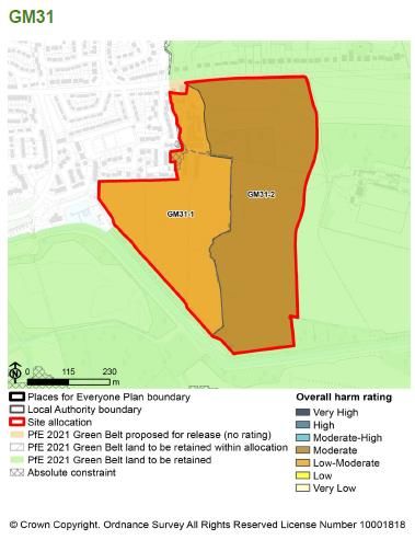
Executive Committee agreed in principle to producing a joint DPD of the nine
       remaining Greater Manchester (GM) districts. Subsequent to this meeting, each
       district formally approved the establishment of a Joint Committee for the preparation
       of a joint Development Plan Document of the nine districts.

1.7    Section 28 of the Planning and Compulsory Purchase Act 2004 and Regulation 32 of
       the Town and Country Planning (Local Planning) (England) Regulations 2012 enable
       a joint plan to continue to progress in the event of one of the local authorities
       withdrawing, provided that the plan has ‘substantially the same effect’ on the
       remaining authorities as the original joint plan. The joint plan of the nine GM districts
       has been prepared on this basis.

1.8    In view of this, it follows that PfE should be considered as, in effect, the same Plan
       as the GMSF, albeit without one of the districts (Stockport). Therefore “the plan” and
       its proposals are in effect one and the same. Its content has changed over time
       through the iterative process of plan making, but its purpose has not. Consequently,
       the Plan is proceeding directly to Publication stage under Regulation 19 of the Town
       and Country Planning (Local Planning) England Regulations 2012.

1.9    Four consultations took place in relation to the GMSF. The first, in November 2014
       was on the scope of the plan and the initial evidence base, the second in November
       2015, was on the vision, strategy and strategic growth options, and the third, on a
       Draft Plan in October 2016.

1.10   The fourth and most recent consultation on The Greater Manchester Plan for
       Homes, Jobs and the Environment: the Greater Manchester Spatial Framework
       Revised Draft 2019 (GMSF 2019) took place in 2019. It received over 17,000
       responses. The responses received informed the production of GMSF 2020. The
       withdrawal of Stockport Council in December 2020 prevented GMSF 2020
       proceeding to Regulation 19 Publication stage and instead work was undertaken to
       prepare PfE 2021.

1.11   Where a local planning authority withdraws from a joint plan and that plan continues
       to have substantially the same effect as the original joint plan on the remaining

           Site Allocation Topic Paper – PfE 2021 – JPA27 East of Boothstown
                                                                                             6
authorities, s28(7) of the Planning and Compulsory Purchase Act 2004 provides that
any step taken in relation to the plan must be treated as a step taken by the
remaining authorities for the purposes of the joint plan. On this basis, it is proposed
to proceed directly to Publication stage under Regulation 19 of the Town and
Country Planning (Local Planning) England Regulations 2012.
1.12 A comprehensive evidence base was assembled to support the policies and
proposals in the GMSF 2020. Given the basis on which the Plan has been prepared,
this evidence base remains the fundamental basis for the PfE 2021 and has
remained available on the GMCA’s website since October 2020. That said, this
evidence base has been reviewed and updated in the light of the change from GMSF
2020 to the PfE 2021 and, where appropriate, addendum reports have been
produced and should be read in conjunction with evidence base made available in
October 2020. The evidence documents which have informed the plan are available
via the GMCA’s website.
Allocation JP27 [East of Boothstown] Overview
2.1 The East of Boothstown site is allocated for new housing in PfE 2021 and is situated
to the immediate east of the established residential area of Boothstown. It is bound
by Leigh Road (A572) to the north, RHS Garden Bridgewater which recently opened
to the east and the Bridgewater Canal to the south, beyond which extends the open
expanse of Chat Moss.
2.2 The allocation provides one of only a few opportunities within Greater Manchester to
deliver very high value housing in an extremely attractive environment, benefitting
not only from an established premium housing market but also a location next to the
RHS Garden Bridgewater and the historic Bridgewater Canal.
Site Details
3.1 The site is located in the ward of Boothstown and Ellenbrook. It is a 30 hectare
greenfield site comprising of open agricultural land, mature woodland (Alder Wood)
Site Allocation Topic Paper – PfE 2021 – JPA27 East of Boothstown
7and hedgerows. The north western part of the site is a vacant former poultry farm
largely occupied by agricultural buildings, whilst there is one residential dwelling on
the site and areas of hardstanding. Shaw Brook runs from north to south through the
site. There are playing fields in the western part of the site.
3.2 The site would be an extension of existing residential development to the west. The
site is designated as a wildlife corridor area of search, and as Green Belt through
policy EN1 of the Salford Saved Unitary Development Plan (2009).
Proposed Development
4.1 The proposed allocation is for 300 houses, including large family houses. The
precise housing mix will be informed by a masterplan/framework or Supplementary
Planning Document (as required by criterion 1 of the policy), and the planning
application process.
4.2 Criterion 2 of the policy requires that development of the site will be required to
provide an affordable housing scheme equivalent to at least 50% of the dwellings on
the site (with an indicative affordable housing tenure split of 37.5% social rented,
37.5% affordable rented and 25% shared ownership), with some of this directed
towards off-site provision. The proportions of affordable housing that will be on and
off-site will be established through the masterplanning and planning application
process, and have regard to the latest evidence of need, discussions with registered
providers and the availability of land. Viability work by Three Dragons has confirmed
that the delivery of 50% affordable at the above tenures is financially viable (see
below for further details).
4.3 Appendix 1 sets out the policy wording and boundary for the East of Boothstown
allocation as set out in PfE 2021.
4.4 There were a number of changes to the wording of the allocation policy between the
2019 Revised Draft GMSF and GMSF 2020 stages. These changes were mainly in
response to comments received to the 2019 allocation policy, updates to the
Site Allocation Topic Paper – PfE 2021 – JPA27 East of Boothstown
8evidence base (including the transport locality assessment1 prepared for the site),
and new evidence with regards to flood risk on the site. Key changes between
GMSF 2019 and 2020 are set out below:
• New criterion added to require a landscaped buffer along the eastern boundary of
the site, facing RHS Garden Bridgewater
• The requirement for development to “Mitigate flood risk and incorporate
sustainable drainage systems” has been replaced by a requirement to provide a
detailed drainage and flood risk management strategy which addresses the
outcomes of the Strategic Flood Risk Assessment, ensuring that the development
is safe and does not increase flood risk elsewhere. In addition, development
should incorporate high quality sustainable drainage systems as part of the green
infrastructure for the site and accommodate sufficient space for any necessary
flood storage, particularly in the south of the site
• Requirement for the provision of a high quality network of pedestrian and cycle
routes through the site, and off site pedestrian crossings and a footpath adjacent
to site on the south side of Leigh Road added to the policy
• Added specific reference to the reasoned justification to the net gain in
biodiversity being a minimum of 10%
4.5 There has been one change to the allocation policy in PfE 2021 when compared to
that in GMSF 2020. This relates to the requirement for any development to be
informed by the published 2019 Heritage Assessment for the site, and any Heritage
Impact Assessment submitted as part of the planning application process. In
addition, the eastern boundary of the allocation has been amended; the previous
GMSF boundary followed the red-line boundary from the RHS Bridgewater planning
application. It did not however reflect any obvious features on the ground. The
entrance road into RHS makes a more logical boundary consistent with NPPF
paragraph 139(f) and this has therefore been used as the eastern boundary for the
East of Boothstown PfE 2021 allocation.
1 Systra (November 2020) Transport Locality Assessments. Introductory note and assessments – Salford
Allocations
Site Allocation Topic Paper – PfE 2021 – JPA27 East of Boothstown
9Site Selection
5.1 The site selection process undertaken to determine the priority allocations to be
taken forward through Places for Everyone is detailed in the associated Site
Selection Background Paper2. Land at East of Boothstown has been selected on the
basis of criterion 7 (land that would deliver significant local benefits by addressing a
major local problem/issue) of the assessment criteria. The site selection background
paper explains that to meet this criterion a site would be required to bring benefits
across a wider area than the development itself and / or would bring benefits to
existing local communities. Examples of the types of benefits are set out below:
• Provide deliverable sites for housing in the north of Greater Manchester where
there is an opportunity to capitalise on an existing high end market housing area
and / or provide an opportunity to diversify the housing market, contributing to the
competitiveness of the north
• Provide a specific type of housing to meet a locally identified need, e.g. older
persons accommodation
• Development would allow for the re-use and enhancement of an at risk heritage
asset
• Development would allow for the provision/retention of unviable community
facility e.g. sports pitches
• Development would deliver significant highway improvements which will help to
resolve existing issues in the wider area.
5.2 It is the site’s ability to provide high end housing to diversify the housing market
within the north of Greater Manchester, and accommodation to meet a specific need,
which places the site under criterion 7. Development would contribute to the spatial
strategy of PfE 2021, particularly significantly increasing the competitiveness of the
northern areas through the selective release of Green Belt in key locations to
diversify housing provision.
2 GMCA (July 2021) Places for Everyone Site Selection Background Paper
Site Allocation Topic Paper – PfE 2021 – JPA27 East of Boothstown
10Planning History
6.1 A large proportion of the general planning history for this area relates to residential
development, either in the form of demolition and rebuild, and extensions to existing
dwellings. There have been some historic agricultural developments (new build and
change of use) and some regrading work by (what was) North West Water. Part of
the site was included within the red line for the Salford Forest Park proposal that was
refused planning permission by Salford City Council. RHS Bridgewater to the east of
the allocation was granted planning permission in summer 2017 and opened in
2021.
GMSF 2019 Consultation Responses
7.1 A large number of objections to the allocation were received with the most significant
numbers relating to the exacerbation of existing issues of congestion along Worsley
Road and Leigh Road, leading back from Junction 13 of the M60. Comments
identified an extended rush hour and very long delays, with the impact of the RHS
Garden yet to be felt given it was under construction at the time. Some comments
suggested that plans should await outputs from the North West Quadrant Study.
Linked to the above, representations referred to inadequate public transport
(specifically a lack of capacity on the, otherwise inaccessible, Vantage service and
that other services had been pulled as a result) and existing issues of air pollution.
7.2 A number of representations were critical of the level of housing need identified
overall, the existing capacity on brownfield sites, and specifically in relation to this
site, the type of housing being proposed not serving local communities.
7.3 A large number of representations objected to the loss of Green Belt / green
infrastructure with a number of related issues including loss of habitats (including
protected species) and recreation opportunities (specifically playing fields to rear of
Falconwood Close and Poynt Chase). A number of other negative impacts on the
area were identified, including the area already being overcrowded from recent
Site Allocation Topic Paper – PfE 2021 – JPA27 East of Boothstown
11developments, a lack of capacity in community and utilities infrastructure, a potential
drop in property values, increased crime and a conflict with the RHS Garden.
GMSF 2019 Integrated Assessment
8.1 A summary of the 2019 Integrated Assessment (IA) conclusions for the proposed
East of Boothstown allocation are set out in section 9 below (alongside the 2020 IA
conclusions).
GMSF 2020 Integrated Assessment
9.1 A summary of the integrated assessment3 conclusions relating to the allocation are
provided in the table below. Other than in respect of impacts relating to the
development of greenfield land in agricultural use, the impacts identified were largely
positive. Possible actions in respect of mitigation identified were considered to have
been adequately addressed through the GMSF Policy itself, thematic policies within
the GMSF and/or local policy proposed through the Publication Salford Development
Management Policies and Designations Document (January 2020). These mitigation
actions are equally addressed through Places for Everyone in place of the GMSF.
9.2 A 2021 PfE Integrated Appraisal Addendum4 has been produced and has reviewed
the changes made between GMSF 2020 and PfE 2021. The addendum identifies a
positive effect on the scoring against the IA Framework, specifically in relation to the
strengthened heritage wording and Objective 16.
Objective Summary of assessment Action on mitigation
and mitigation identified
1.Provide a Positive impacts arising from Subsequent to this an
sustainable provision of housing and the assumption relating to
supply of housing site’s proximity to green the total number of
3 Arup (January 2019, and October 2020) Integrated Assessment of the Greater Manchester Spatial
Framework
4 Arup (July 2021) Places for Everyone Integrated Appraisal Addendum
Site Allocation Topic Paper – PfE 2021 – JPA27 East of Boothstown
12Objective Summary of assessment Action on mitigation
and mitigation identified
land including for spaces, playing fields and dwellings was added to
an appropriate footpaths. the policy (and have
mix of sizes, been carried forward
types, tenures in Despite this the 2019 into PfE 2021).
locations to meet integrated assessment
housing need, identified as mitigation that The mix on the site will
and to support reference could be made to be determined through
economic growth the number of dwellings to be masterplanning and
provided and details regarding having regard to
the mix. national, GMSF (now
PfE 2021) and Local
Plan policies.
2 Provide a Positive impacts relating to Issue identified
sustainable policy requirements on school considered to be a
supply of provision. No negative impacts detailed one relevant to
employment land identified. a range of sites and
to ensure more appropriately
sustainable Identified as mitigation giving addressed through
economic growth consideration as to how thematic policies at the
and job creation housing land can enhance sub-regional and/or local
work force skills and training, level.
such as through construction
jobs. The Publication Salford
Local Plan (January
2020) proposes policy
requirements in relation
to this issue.
3.Ensure that Positive impacts relating to The recommended
there is sufficient policy requirements including mitigation is addressed
coverage and access to public transport by GMSF thematic
capacity of policies GM-E 1 and
Site Allocation Topic Paper – PfE 2021 – JPA27 East of Boothstown
13Objective Summary of assessment Action on mitigation
and mitigation identified
transport and services and high quality GM-N 2 (in PfE 2021
utilities to support pedestrian routes. these are policies JP-P
growth and 1 and JP-C 1), and a
development Identified as mitigation to masterplan for the site
consider a feasibility study into as required by the
utilities/ digital infrastructure allocations policy would
requirements and ability of also address the issue.
local network to support
development.
4.Reduce levels Identified impacts as uncertain The importance of social
of deprivation and as it was considered uncertain value as part of new
disparity that development would affect development in the city
deprived areas. is clearly set out in the
Publication Salford
Mitigation identified in respect Local Plan (January
of considering deprived areas 2020) along with
in relation to benefits such as associated policy
creation of construction and requirements.
operational employment, or
improved transport links or It is also addressed by
increases in the range of GMSF thematic policies
community facilities. GM-E 1, GM-E 4, GM-E
5 and GM-P 1 (in PfE
2021 these are policies
JP-P 1, JP-P 4, JP-P 5
and JP-J 1).
5.Promote Identified a neutral impact in Subsequent to this
equality of relation to this objective. recommendation
opportunity and detailed requirements in
relation to affordable
Site Allocation Topic Paper – PfE 2021 – JPA27 East of Boothstown
14Objective Summary of assessment Action on mitigation
and mitigation identified
the elimination of As mitigation it was identified housing were added to
discrimination that the policy could reference the policy in GMSF (and
integration with existing these are carried
communities and also forward into PfE 2021).
encourage the provision of
varied tenures within the In respect of the other
development. issues raised, the policy
requirement for
masterplanning to be
developed with the local
community and other
stakeholders could be
significant in this regard.
Other issues of equality
and opportunity area
addressed in thematic
policies of the GMSF
(and now PfE 2021) and
the Publication Salford
Local Plan. In terms of
the latter, policy
requirements include
those relating to
fairness, equality of
access and design.
6. Support A largely positive impact was No mitigation identified.
improved health identified citing policy
and wellbeing requirements relating to
of the population pedestrian routes, protection of
and reduce health natural features, including the
inequalities
Site Allocation Topic Paper – PfE 2021 – JPA27 East of Boothstown
15Objective Summary of assessment Action on mitigation
and mitigation identified
neighbouring SBI, and the
provision of allotment plots.
7. Ensure access A lack of reference to Mitigation to be
to and provision healthcare facilities resulted in addressed through
of appropriate a negative/uncertain impact in masterplanning and is
social this regard. Positive impacts also addressed in
infrastructure resulting from requirements in thematic policies GM-E
relation to school provision and 5, GM-E 6 and GM-E 7
allotments. (in PfE 2021 these are
policies JP-J 5, JP-J 6
As mitigation it was identified and JP-J 7).
that ensuring healthcare
provision is accessible to all is The Publication Local
considered through Plan included additional
masterplanning. requirements in relation
to health provision.
8. Support Policy requirement relating to No mitigation identified.
improved school provision is identified as
educational a major positive. A neutral
attainment and impact is identified in relation
skill levels for all to the education and skill
levels in the working age
population as it is not covered
in the policy.
9. Promote Positive impact identified with No mitigation identified.
sustainable references to encouraging use
modes of nearby public transport and
of transport high quality pedestrian routes.
10. Improve air A positive/negative impact is The issues identified
quality within identified, the assessment can be addressed
Greater referencing proximity to the through masterplanning
Site Allocation Topic Paper – PfE 2021 – JPA27 East of Boothstown
16Objective Summary of assessment Action on mitigation
and mitigation identified
Manchester, AQMA and also that the policy and are also addressed
particularly in the supports the use of active through thematic
10 Air Quality modes and public transport. policies in PfE 2021.
Management
Areas (AQMAs) Seeking to minimise private The allocation policy
car use and considering includes requirements
mitigation solutions including which seek to
green infrastructure, encourage public
incentivising electric car use transport use, and this is
and/or masterplan layout supplemented by policy
which reduces emissions near requirements in the
sensitive receptors are all Publication Salford
identified as mitigation. Local Plan. The Local
Plan also includes
requirements relating to
electric vehicle charging
and the incorporation of
green infrastructure
within development.
11. Conserve and The assessment identifies both The justification for the
enhance positive and negative impacts policy includes
biodiversity, in relation to this objective reference to a minimum
green citing the site’s location within 10% net gain in
infrastructure and a wildlife corridor, proximity to biodiversity. Issues are
geodiversity a protected habitat and also addressed within
assets adjacency to Worsley Woods the thematic policies of
(an SBI). Also referenced are PfE 2021 and the
policy requirements relating to Salford Local Plan.
the protection of the SBI and
other natural features. The
Site Allocation Topic Paper – PfE 2021 – JPA27 East of Boothstown
17Objective Summary of assessment Action on mitigation
and mitigation identified
requirement for allotment plots
is also identified.
12. Ensure A neutral impact identified, the No action required
communities, site is relatively low flood risk
developments and policy requires
and infrastructure incorporation of sustainable
are resilient to the drainage systems to mitigate
effects of surface water flooding.
expected climate
change Issue is also addressed in
thematic policies of PfE 2021
and the Publication Salford
Local Plan.
13. Reduce the A neutral impact identified, the No action required
risk of flooding to site is relatively low flood risk
people and and policy requires
property incorporation of sustainable
drainage systems to mitigate
surface water flooding.
Issue is also addressed in
thematic policies of PfE 2021
and the Publication Salford
Local Plan.
14. Protect and Positive impact identified. The No action required
improve the policy requires development to
quality and protect the quality of
availability of watercourses through and
water resources around the site.
Site Allocation Topic Paper – PfE 2021 – JPA27 East of Boothstown
18Objective Summary of assessment Action on mitigation
and mitigation identified
Issue is also addressed in
thematic policies of PfE 2021
and the Publication Salford
Local Plan.
15. Increase A positive impact identified in Issues are addressed in
energy efficiency, relation to the promotion of thematic policies in the
encourage low cycling and walking, but GMSF (and now PfE
carbon negative/uncertain impacts 2021) and a number of
generation and given a lack of reference to low policies within the
reduce carbon and renewable energy Publication Salford
greenhouse gas facilities and a proactive Local Plan including in
emissions reduction in direct and indirect relation to climate
greenhouse gases. change, design, access
and energy.
The assessment
recommended making
reference to energy efficiency
directly and ways that
it can be increased, such as
highlighting the benefits of
sustainable modes of transport
16. Conserve Positive impacts identified in Mitigation issues
and/or enhance relation to retention of identified are addressed
landscape, landscape features and by separate thematic
townscape, ensuring that vehicular access policies in the GMSF
heritage assets does not compromise the (and now PfE 2021) and
and their setting quality of existing residential policies within the
and the character areas. Publication Local Plan in
of GM respect of heritage,
In respect of mitigation, the design and green
assessment identifies a need infrastructure.
Site Allocation Topic Paper – PfE 2021 – JPA27 East of Boothstown
19Objective Summary of assessment Action on mitigation
and mitigation identified
to consider heritage assets Masterplanning
outside of the site throughout requirements provide an
the detailed design to reduce opportunity to consider
risk throughout construction the issues raised further.
and operational phases.
A heritage impact
Mitigation also includes a need assessment of the
to ensure that the policy is allocation has been
designed to take advantage of undertaken. Additional
the natural landscape assets text has been added to
and connections to these both the PfE 2021 allocation
on and off site and also policy to require any
townscape assets that are development to be
present. informed by the published
2019 Heritage
Assessment for the site,
and any Heritage Impact
Assessment submitted as
part of the planning
application process.
17. Ensure that Major negative impacts Previously developed
land resources identified resulting from the land opportunities within
are allocated and development of greenfield land the city are identified
used in an in agricultural use. through Salford’s
efficient and Housing and Economic
sustainable Mitigation included: Land Availability
manner to meet Assessment (and
the housing and • Consider how PDL brownfield register). No
employment development and the particular opportunities
development of derelict
Site Allocation Topic Paper – PfE 2021 – JPA27 East of Boothstown
20Objective Summary of assessment Action on mitigation
and mitigation identified
needs of GM, land, properties and relating specifically to
whilst reducing infrastructure could be the site are apparent.
land encouraged as a result of
contamination development Mitigation is included
• Further research into within chapter 4 and
agricultural land quality chapter 9 of the GMSF
(and now in these
chapters in PfE 2021).
18. Promote A neutral impact is identified These issues are
sustainable due to a lack of specific specifically addressed in
consumption of reference within the policy. the Publication Salford
resources and Local Plan including
support the Mitigation included the policy requirements
implementation of promotion of sustainable relating to efficient and
the waste construction methods and coordinated use of land,
hierarchy giving consideration to waste energy, design and
and recycling facilities in waste.
design.
GMSF thematic policy
GM-S 7 also addresses
the issues (in PfE 2021
this is policy JP-S 7).
Site Allocation Topic Paper – PfE 2021 – JPA27 East of Boothstown
21Section B – Physical
Transport
10.1 A Locality Assessment5 was prepared for the site allocation in order to confirm the
potential transport impacts and identify appropriate mitigation to support its inclusion
in GMSF 2020. The Locality Assessment for the East of Boothstown site concludes
that the allocation is deliverable, and the traffic impacts of the site are considered to
be ‘less than severe’ in the context of the National Planning Policy Framework
(paragraph 109). It should be noted that the assessment is considered to be a ‘worst
case’ scenario which does not take full account of the extensive opportunities for
mode shift toward active travel and public transport improvements associated with
the significant continued investment proposals within the Greater Manchester 2040
Transport Strategy.
10.2 The Locality Assessment has considered the impacts of the site allocation in
isolation and in the context with other nearby sites such as the Hazelhurst Farm, and
the North of Mosley Common allocation in Wigan. Results from the modelling work
indicate that the allocation in isolation has a limited impact on the A580 East
Lancashire Road and A572 Leigh Road. As a consequence of this, no highway
mitigation has been deemed necessary to accommodate the additional demand
generated to or from the allocation.
10.3 Mitigation has been investigated at the A580 East Lancashire Road Junction with
A577 Mosley Common Road and the A572 Leigh Road/ A577 Mosley Common
Road Junction. Flows associated with the proposed East of Boothstown allocation
are considered to be negligible at both junctions and would not therefore directly
necessitate funding any improvement. A scheme for the A580 East Lancashire Road
Junction with A577 Mosley Common Road is being funded through Section 106
monies which would improve the operation of the junction.
5 Systra (November 2020) Transport Locality Assessments. Introductory note and assessments – Salford
Allocations
Site Allocation Topic Paper – PfE 2021 – JPA27 East of Boothstown
2210.4 Modelling was undertaken for junction 13 of the M60 at the roundabouts at Worsley
Brow. This indicates that the junction operates above capacity in the reference case
and is broadly comparable in the ‘with GMSF’ scenarios. A scheme to improve the
operation of the roundabouts at Junction 13 has recently been completed.
10.5 With regards to sustainable transport modes, Boothstown is served by a range of
public transport services, with bus stops provided along the A572 Leigh Road
serving the Regional Centre to the east and Leigh / Wigan to the west. These
provide a 30-minute frequency, whilst the more frequent V1/V2 bus services (Leigh-
Salford-Manchester Bus Rapid Transit) run along the A580 East Lancashire Road to
the north 1km from the site. A footpath runs north-south through the allocation and
there is also a footpath along the northern bank of the canal and a cycle path along
the southern towpath which can be accessed via the Vicars Hall Lane bridge
crossing. Footways are provided along parts of Leigh Road, providing access to bus
stops. The Locality Assessment identifies some walking and cycling improvements
which would improve the site’s accessibility by sustainable modes, these include:
• Footpath along Leigh Road (£95k)
• Footpath from canal to Occupation Rd access
• A572 Leigh Rd crossing
• B5232 Newearth Rd crossing
• Permeable network for active travel priority within the development
10.6 The 2020 GMSF site allocation policy was updated to incorporate these
requirements and further sustainable transport measures may be identified through
the masterplanning process. It explains that the development shall: ensure good
quality access by walking and cycling for all residents to services and facilities in
Boothstown and the local area, bus services on the surrounding road network, the
Bridgewater Canal and Chat Moss to the south, including through the provision of a
high-quality network of pedestrian and cycle routes through the site; and provide off-
site pedestrian crossings and a footpath adjacent to the site on the south side of
Leigh Road. These updates have been carried forward into the site allocation policy
within PfE 2021. It is considered that improving connectivity for sustainable modes
Site Allocation Topic Paper – PfE 2021 – JPA27 East of Boothstown
23throughout the allocation and in proximity to the allocation would allow for greater
connectivity to the established public transport network.
10.7 Two vehicular site accesses are likely to be required to serve the allocation providing
a primary access, and a secondary access in the event of an emergency. The
primary access would be provided from a priority access off Occupation Road. A
large signalised junction is provided at the junction with the A572 Leigh Road, which
also serves the Royal Horticultural Society Garden Bridgewater, which recently
opened. Given the anticipated level of demand to and from the allocation, a ghost
island junction arrangement is considered appropriate at Occupation Road. This
junction has been tested in the 2040 future scenario and is considered to operate
within capacity. If required, a secondary access (to be used in the event of an
emergency) could be taken from Quayside Close to the south west of the allocation.
10.8 In order to ensure that the findings of the 2020 Locality Assessments remain robust
with the change from GMSF2020 to PfE 2021 a review of their conclusions has been
undertaken. The Salford City Council Locality Assessment Update Note6 (July 2021)
identifies whether any of the changes (which include the removal of some allocations
from the plan, changes to the quantum of development within some allocations and
the withdrawal of Stockport Council and their associated allocations from the plan)
are likely to significantly impact on the conclusions in relation to proposed site
allocations in Salford. A further round of modelling has also been undertaken as part
of this update and the impact on relevant junctions has been reassessed as
considered necessary.
10.9 With regards to East of Boothstown allocation, whilst the updated modelling indicates
some flow differences when compared to the previous assessment and a greater
impact on the A580/Walkden Road junction, these are largely due to wider changes
to the network since the previous assessment was undertaken. The Update Note
concludes that the previous locality assessment gave an indication that the traffic
impacts of the allocation are less than severe, and that with no changes to the
development quantum and subsequent vehicular trip generation, these conclusions
6 SYSTRA (July 2021) Salford City Council Locality Assessment Update
Site Allocation Topic Paper – PfE 2021 – JPA27 East of Boothstown
24remain robust. It also considers that the wider network changes do not affect the
requirement for the interventions as identified in paragraph 10.5 of this topic paper.
Flood Risk and Drainage
11.1 Shaw Brook runs in a southerly direction through the site from the northern to the
southern boundary, with a tributary joining in the northern part of the site.
11.2 Broad scale flood modelling for the Strategic Flood Risk Assessment (SFRA)7 has
shown a greater fluvial flood risk on this site than previously thought. The city council
is currently working with the landowner and their consultants to find a solution to this
issue. It is anticipated that the proposed number of dwellings can be delivered safely
on the site and further evidence is expected to be produced to support this, based on
more detailed modelling of the flood risk. Therefore, the SFRA concludes that it is
likely that development on this site can pass the Exception Test once detailed fluvial
modelling information is available.
11.3 The broad scale modelling shows that in a 1 in 100 year event (i.e. a flood which has
a 1% probability of occurring in any given year), large areas of the central and
southern parts of the site would be flooded, mostly by shallow water, but with deeper
water along the Shaw Brook corridor and at the southern end of the site. Once
climate change is taken into account, both the area and depth of flooding increase.
11.4 Surface water flooding follows a similar pattern to the fluvial flooding, with water
pooling largely at the southern end of the site, particularly in an extreme event. It is
anticipated that on this site measures to mitigate surface water flooding and
measures to mitigate fluvial flooding would complement each other. Both are being
addressed in ongoing discussions with the landowner regarding flood risk.
11.5 Some land within the site would need to be used for high quality sustainable
drainage systems to mitigate the surface water flooding issues. Sufficient open land
7 JBA consulting (March 2019) Level 1 Strategic Flood Risk Assessment for Greater Manchester – Update
Site Allocation Topic Paper – PfE 2021 – JPA27 East of Boothstown
25within the site area would also need to be left to provide for suitable storage of flood
water in the event of a fluvial flood, to compensate for any loss of flood storage as a
result of the development, ensuring that there is no increase in flood risk elsewhere
and that the development would be safe for its lifetime.
11.6 The flood risk review undertaken on behalf of the landowner8 has demonstrated that
fluvial flows to the adjacent RHS site can be attenuated through works to this site,
which would divert overland flows which currently reach the RHS site into the
network of sustainable drainage systems proposed for this site. The GMSF 2020
allocation was been amended to take into account the above issues and ensure that
adequate flood risk mitigation is provided. These amendments have been carried
forward into PfE 2021 at criteria 5 and 6.
Ground Conditions
12.1 Agricultural land data suggests that the entire site comprises grade 3 agricultural
land (grades 1, 2 and 3a are defined as the best and most versatile). Grade 3 land is
subdivided into sub grade 3a (good quality land) and sub grade 3b (moderate quality
land). There is however no detailed Agricultural Land Classification data available for
the site.
12.2 The majority landowner has undertaken an assessment of the agricultural land
classification of the site allocation9 which is published alongside PfE 2021 for
information. The assessment of the agro-climatic conditions indicates that whilst the
number of field capacity days (i.e. the period from autumn to spring where soil
moisture deficit is zero) is considered to be unfavourable for agricultural land
working, there is no overriding climatic limitation to agricultural land quality. The soil
survey mapping shows the Brickfield 3 association across the majority of the site,
with Turbary Moor soils in the south. The appraisal explains that the Brickfield 3
8 WSP (May 2020) GM Allocation 31 – Land East of Boothstown, Salford: Site Appraisal – Drainage and Flood
Risk. Also letter from WSP dated 17 July 2020 regarding the above
9Reading Agricultural Consultants Ltd (November 2019) Agricultural Lane Quality, Land East of Boothstown.
Site Allocation Topic Paper – PfE 2021 – JPA27 East of Boothstown
26association is characterised by predominantly loamy and clayey surface-water gley
soils that are waterlogged for much of the year and cultivation can be difficult. The
Turbary Moor soils comprise peat throughout, where uncultivated the soils are very
acidic with high groundwater levels. The soils can be improved for arable crops by
draining using pumped ditches combined with field drains.
12.3 The report concludes that the soils are affected by wetness and workability and are
most likely to be of sub-grade 3b, with the potential for sub-grade 3a and 4 to be
present. Based on the adjacent survey data the report considers that soils mapped
to the south of the site are likely to be of a better quality.
Utilities
13.1 United Utilities has advised that there is a large gravity sewer running east to west
through the central part of the site, with a smaller gravity main running north to south
through the north west corner of the site. In addition to this, there is a large trunk
main with formal easements running north to south through the site. Having regard to
these issues, the allocation policy requires that the development of the site provides
an easement for the significant utilities infrastructure running through and near the
site (criterion 15). The majority landowner has prepared a development framework
for the site, which indicates that the relevant easements can be accommodated
within the development proposals and would not constrain delivery.
13.2 Cadent has indicated that, due to this site connecting near one of their extremities,
reinforcement may be required to ensure that there is enough pressure at the
connection point. The demand is estimated to be 300scm/h at peak or 3,250kwh (on
the assumption that all homes connect to the gas network). The need for this would
be assessed in detail at the time the connection request is submitted to Cadent.
13.3 Electricity North West (ENWL) estimates that the total electrical demand (the peak
demands used to determine the size of the connections required for each
development) associated with this site is 0.42MW. The demands associated with the
city’s baseline supply of housing and employment sites and the four PfE 2021
Site Allocation Topic Paper – PfE 2021 – JPA27 East of Boothstown
27allocations in Salford totals 240.3 MW. To inform their plans for the network, ENWL
forecast how customers would use and generate electricity in their annual
Distribution Future Electricity Scenarios (DFES) and information on developments
are an important input to this. In assessing the impact of all proposed developments
in Salford up to 2037 on the network, ENWL makes assumptions about the average
electrical demand of each type of development (each house would be heated by gas
and half of the apartments would have electrical heating and the other half would
have heat pumps which significantly increase the electrical requirements of the
property. Assumptions are also made about the electrical consumption of the
industrial and commercial spaces). The assessment is therefore an approximation,
recognising that customers would change their needs over the same timescales.
13.4 ENWL has indicated that there is approximately 21.7MW space capacity within
Salford’s 11 primary substations. ENWL concludes that by 2037, additional electrical
demands would exceed spare capacity if all of the developments are realised such
that their network. ENWL would therefore need to expand their network, and
although would first consider using the existing network more flexibly, the size of the
estimated new capacity is likely to mean that new Primary substations would be
needed. These are issues associated with accommodating the wider development
requirements within Salford rather than being specific to this site. ENW has indicated
that requirements would depend on the precise timing and extent of developments,
interacting with the altered needs of other customers. Ongoing dialogue between the
city council and ENWL would therefore be important and the masterplanning process
provides an opportunity to consider further any site-specific requirements.
Site Allocation Topic Paper – PfE 2021 – JPA27 East of Boothstown
28Section C – Environmental
Green Belt Assessment
The allocation would result in the removal of 30.3 hectares of existing Green Belt.
29.8 hectares of this land would be within the development allocation itself and a
further 0.5 hectares along the northern boundary of the allocation to exclude: existing
dwellings falling between the allocation and the residential area of Boothstown and
Ellenbrook; and Leigh Road to the immediate north of the site, with the new Green
Belt boundary being drawn along its northern edge.
Exceptional Circumstances
14.1 The strategic level exceptional circumstances for site allocations within the current
Green Belt are set out in detail in a Topic Paper10, with the key driver being the need
10 GMCA (Julyr 2021) Green Belt Topic Paper
Site Allocation Topic Paper – PfE 2021 – JPA27 East of Boothstown
29to deliver the ambitions set out in the Greater Manchester Strategy and the
objectively assessed need for both employment and housing. East of Boothstown
has been selected to deliver part of the identified dwelling requirement as one of only
a few opportunities across Greater Manchester to provide very high value homes in
an extremely attractive environment11.
14.2 At the local level the site would contribute to a wider mix of dwellings coming forward
in the city (particularly houses in Salford West) with the existing pipeline heavily
weighted towards apartment development reflecting the city’s location at the heart of
the GM conurbation and forming part of the City Centre. The allocation would also
deliver a significant number of affordable dwellings, with the allocation policy
requiring the provision of an affordable housing scheme equivalent to at least 50% of
the 300 dwellings to be provided, with some of this being off-site.
14.3 The allocation policy identifies a number of requirements for the development of the
site some of which have the potential to bring wider benefits. These are discussed in
greater detail elsewhere in this topic paper but include: improvements to the footway
to the south of Leigh Road and the northern path alongside the Bridgewater Canal;
the opportunity to enhance the ecological value of Shaw Brook; a minimum 10%
biodiversity net gain; and the provision of a neighbourhood equipped area of play
and allotments.
Contribution to Green Belt purposes
14.4 An assessment of the contribution that parts of the Greater Manchester Green Belt
make to the Green Belt purposes defined in national policy was published in 201612.
The allocation was assessed as part of parcel SA23 in that document, which also
included Green Belt land to the east.
11 GMCA (July 2021) Places for Everyone Site Selection Background Paper – criterion 7
12 LUC (2016) Greater Manchester Green Belt Assessment
Site Allocation Topic Paper – PfE 2021 – JPA27 East of Boothstown
3014.5 A summary of this assessment is shown in the table below:
GB Purpose Assessment Conclusion on
contribution
Purpose 1 - Check the
unrestricted sprawl of
large built up areas
1a - Does the parcel exhibit There are a few urbanising Strong
evidence of existing urban features within the parcel but
sprawl and consequent loss there is a strong sense of
of openness? openness because they are set
within a mixed land use of
woodland, a small lake to the
east and farmland to the west.
1b - Does the parcel protect The parcel plays a strong role in Strong
open land from the potential inhibiting ribbon development to
for urban sprawl to occur? the south and east of the A572
and along the road leading to
Site Allocation Topic Paper – PfE 2021 – JPA27 East of Boothstown
31the Garden Centre and Scout
Hall.
Purpose 2 – To prevent
neighbouring towns
merging into one another
Does the parcel prevent the The parcel forms part of a Strong
merging or erosion of the critical gap between the
visual or physical gap settlements of Boothstown and
between neighbouring Ellenbrook to the west and
settlements? Worsley to the east. Parcels
SA20 and SA21 also form part
of this gap.
Purpose 3 – To assist in
safeguarding the
countryside from
encroachment
Does the parcel have the The parcel is rural in character Strong
characteristics of countryside and displays characteristics of
and/or connect to land with the countryside.
the characteristics of
countryside?
Has the parcel already been
affected by encroachment of
urbanised built
development?
Purpose 4 - To preserve
the setting and special
character of historic towns
Does the parcel contribute to The parcel plays a role in the Moderate
the setting and ‘special setting of the historic settlement
character’ of a historic of Worsley, but to a limited
town(s)? degree.
Site Allocation Topic Paper – PfE 2021 – JPA27 East of Boothstown
32Purpose 5 - Assist in urban The assessment does not N/a
regeneration by provide a parcel by parcel
encouraging the recycling assessment in relation to this
of derelict and other urban purpose given difficulties in
land distinguishing the extent to
which individual parcels delivers
against it.
Potential Impact on the Green Belt
14.6 Further to the above, an assessment of the potential harm to the Green Belt arising
from the allocation’s release has been undertaken.
14.7 An initial assessment of the impact of the allocation as was proposed in the Revised
Draft GMSF was completed in September 202013. Very minor changes to the
boundary were proposed in GMSF 2020 in order to correct mapping errors on the
allocation’s western boundary. These changes would not affect the conclusions
reached in respect of Green Belt harm and as such the assessment was not updated
at that stage.
14.8 An update to that assessment has however been published alongside Places for
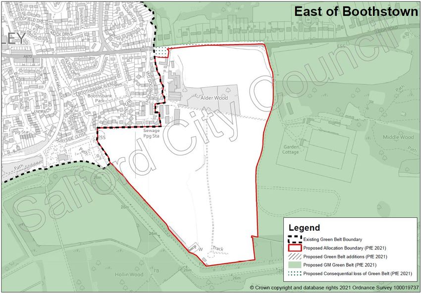
Everyone 2021 to reflect the more significant change proposed to the allocation’s
eastern boundary14. The image below, taken from the most recent assessment,
shows both the GMSF 2020 version of the allocation and that now included within
PfE 2021.
13 LUC (September 2020) Stage 2 Greater Manchester Green Belt Study, Assessment of Proposed 2019
GMSF Allocations
14 LUC (June 2021) Stage 2 Greater Manchester Green Belt Study Addendum: Assessment of Proposed 2021
PfE Plan Allocations
Site Allocation Topic Paper – PfE 2021 – JPA27 East of Boothstown
33You can also read