Biodiversity Assessment: Stages 26-29, Stonehill Development, West Maddingly, Victoria
←
→
Page content transcription
If your browser does not render page correctly, please read the page content below
Final Report

Biodiversity Assessment: Stages 26-29, Stonehill
Development, West Maddingly, Victoria

Prepared for
Townsville City Project Pty Ltd

July 2021

Ecology and Heritage Partners Pty Ltd

    MELBOURNE: 292 Mt Alexander Road, Ascot Vale VIC 3032 GEELONG: 230 Latrobe Terrace, Geelong West VIC 3218
        BRISBANE: Level 22, 127 Creek Street, Brisbane QLD 4000 ADELAIDE: 78 Edmund Avenue, Unley SA 5061
         CANBERRA: 19-23 Moor Street, Turner ACT 2612 SYDNEY: Level 5, 616 Harris Street, Ultimo NSW 2007
                                       www.ehpartners.com.au | 1300 839 325
DOCUMENT CONTROL
                    Assessment type       Biodiversity Assessment
                             Address      Stages 26-29, Stonehill Development, West Maddingly, Victoria
                      Project number      14464
                    Project manager       Claire Ranyard (Senior Botanist)
                     Report reviewer      Andrew Hill (Director – Principal Ecologist)
                     Other EHP staff      Elyse Harrison (Botanist)
                            Mapping       Petra Sorenson (GIS Officer)
                           File name      14464_EHP_BA_Stages26-29_Stonehil_Finalv2_30072021
                               Client     Townsville City Project Pty Ltd
                           Bioregion      Victorian Volcanic Plain
Catchment Management Authority            Port Phillip and Westernport
                              Council     Moorabool Shire Council

VERSION CONTROL
 Report versions                              Comments                             Comments made by:      Date submitted

Draft                  Report sent to client for review                                     -              19/02/2021
                       Report updated to reflect amended development                                       13/05/2021
Final                                                                                       EH
                       plan and comments from client
                       Report updated to incorporate significance                                          30/07/2021
Finalv2                                                                                     EH
                       assessment for Golden Sun Moth

                                        Copyright © Ecology and Heritage Partners Pty Ltd
               This document is subject to copyright and may only be used for the purposes for which it was
          commissioned. The use or copying of this document in whole or part without the permission of Ecology and
                                 Heritage Partners Pty Ltd is an infringement of copyright.
                                                            Disclaimer

                                                                                                                           2
                             Stage 26 – 29 Stonehill Development: Biodiversity Assessment, Victoria
Although Ecology and Heritage Partners Pty Ltd have taken all the necessary steps to ensure that an
              accurate document has been prepared, the company accepts no liability for any damages or loss incurred
                                   as a result of reliance placed upon the report and its contents.

CONTENTS
SUMMARY OF CLAUSE 52.17 APPLICATION REQUIREMENTS . . . . . . . . . . . . . . . . . . . . . . . . . . . . . . . .. . . . . . . . . . 6

1     INTRODUCTION . . . . . . . . . . . . . . . . . . . . . . . . . . . . . . . .. . . . . . . . . . . . . . . . . . . . . . . . . . . . . . . .. . . . . . . . . . . . . . . . . . . . . . . . . . . . . . . . 8
    1.1         Background ........................................................................................................................................ 8

    1.2         Study Area.......................................................................................................................................... 8
    1.3         Golden Sun Moth Targeted Surveys .................................................................................................. 8

2     METHODS . . . . . . . . . . . . . . . . . . . . . . . . . . . . . . . .. . . . . . . . . . . . . . . . . . . . . . . . . . . . . . . .. . . . . . . . . . . . . . . . . . . . . . . . . . . . . . . .. . . . . 10

    2.1         Desktop Assessment ........................................................................................................................ 10
    2.2         Field Assessment .............................................................................................................................. 11
      2.2.1               Vegetation assessment ............................................................................................................ 11
      2.2.2               Golden Sun Moth Targeted Surveys......................................................................................... 11
    2.3         Removal, Destruction or Lopping of Native Vegetation (the Guidelines) ........................................ 11
      2.3.1               Assessment Pathway................................................................................................................ 12
      2.3.2               Vegetation Assessment ............................................................................................................ 12
      2.3.3               Impact Avoidance and Minimisation ........................................................................................ 13
      2.3.4               Offsets ...................................................................................................................................... 13
    2.4         Assessment Qualifications and Limitations ...................................................................................... 13

3     RESULTS . . . . . . . . . . . . . . . . . . . . . . . . . . . . . . . .. . . . . . . . . . . . . . . . . . . . . . . . . . . . . . . .. . . . . . . . . . . . . . . . . . . . . . . . . . . . . . . .. . . . . . . 14
    3.1         Vegetation Condition ....................................................................................................................... 14

      3.1.1               Patches of Native Vegetation ................................................................................................... 14
      3.1.2               Large Trees in Patches ............................................................................................................. 15
      3.1.3               Scattered Trees ........................................................................................................................ 15
      3.1.4               Introduced and Planted Vegetation ......................................................................................... 15
    3.2         Fauna Habitat................................................................................................................................... 16
    3.3         Removal, Destruction or Lopping of Native Vegetation (the Guidelines) ........................................ 16
      3.3.1               Vegetation proposed to be removed ....................................................................................... 16
      3.3.2               Offset Targets........................................................................................................................... 17

                                                                                                                                                                                                                         3
                                                Stage 26 – 29 Stonehill Development: Biodiversity Assessment, Victoria
3.4            Significance Assessment .................................................................................................................. 17
          3.4.1               Flora ......................................................................................................................................... 17

          3.4.2               Fauna ....................................................................................................................................... 18
          3.4.3               Ecological Communities ........................................................................................................... 19

4         LEGISLATIVE AND POLICY IMPLICATIONS . . . . . . . . . . . . . . . . . . . . . . . . . . . . . . . .. . . . . . . . . . . . . . . . . . . . . . . . . . . . 21

     4.1            Environment Protection and Biodiversity Conservation Act 1999 (Commonwealth) ....................... 21
          4.1.1               Implications .............................................................................................................................. 21
     4.2            Flora and Fauna Guarantee Act 1988 (Victoria)............................................................................... 23
          4.2.1               Implications .............................................................................................................................. 23
     4.3            Planning and Environment Act 1987 (Victoria) ................................................................................ 23
          4.3.1               Local Planning Scheme ............................................................................................................. 23
          4.3.2               The Guidelines ......................................................................................................................... 23
          4.3.3               Implications .............................................................................................................................. 23
     4.4            Catchment and Land Protection Act 1994 (Victoria) ........................................................................ 24

5         MITIGATION MEASURES . . . . . . . . . . . . . . . . . . . . . . . . . . . . . . . .. . . . . . . . . . . . . . . . . . . . . . . . . . . . . . . .. . . . . . . . . . . . . . . . . . 25
     5.1            Avoid and Minimise Statement ........................................................................................................ 25
     5.2            Best Practice Mitigation Measures .................................................................................................. 25
     5.3            Offset Impacts and Strategy............................................................................................................. 25

6         FURTHER REQUIREMENTS . . . . . . . . . . . . . . . . . . . . . . . . . . . . . . . .. . . . . . . . . . . . . . . . . . . . . . . . . . . . . . . .. . . . . . . . . . . . . . . . 26

REFERENCES. . . . . . . . . . . . . . . . . . . . . . . . . . . . . . . .. . . . . . . . . . . . . . . . . . . . . . . . . . . . . . . .. . . . . . . . . . . . . . . . . . . . . . . . . . . . . . . .. . . . . . . . 27

FIGURES . . . . . . . . . . . . . . . . . . . . . . . . . . . . . . . .. . . . . . . . . . . . . . . . . . . . . . . . . . . . . . . .. . . . . . . . . . . . . . . . . . . . . . . . . . . . . . . .. . . . . . . . . . . . . 29

APPENDIX 1 FLORA . . . . . . . . . . . . . . . . . . . . . . . . . . . . . . . .. . . . . . . . . . . . . . . . . . . . . . . . . . . . . . . .. . . . . . . . . . . . . . . . . . . . . . . . . . . . . . . 34
     Appendix 1.1 Flora Results ........................................................................................................................... 34
     Appendix 1.2 Habitat Hectare Assessment .................................................................................................. 36
     Appendix 1.3 Significant Flora Species ......................................................................................................... 37

APPENDIX 2 FAUNA . . . . . . . . . . . . . . . . . . . . . . . . . . . . . . . .. . . . . . . . . . . . . . . . . . . . . . . . . . . . . . . .. . . . . . . . . . . . . . . . . . . . . . . . . . . . . . 45
     Appendix 2.1 Significant Fauna Species ....................................................................................................... 45

APPENDIX 3 NATIVE VEGETATION REMOVAL (NVR) REPORT . . . . . . . . . . . . . . . . . . . . . . . . . . . . . . . .. . . . . . . . 53

                                                                                                                                                                                                                               4
                                                    Stage 26 – 29 Stonehill Development: Biodiversity Assessment, Victoria
APPENDIX 4 AVAILABLE NATIVE VEGETATION CREDITS . . . . . . . . . . . . . . . . . . . . . . . . . . . . . . . .. . . . . . . . . . . . . . . 63

                                                                                                                                             5
                                 Stage 26 – 29 Stonehill Development: Biodiversity Assessment, Victoria
SUMMARY OF CLAUSE 52.17 APPLICATION REQUIREMENTS
Table S1. Application requirements for a permit to remove native vegetation (Victoria Planning Provisions Clause
52.17; DELWP 2017)

     No.                              Application Requirement                                          Response
                           Application requirements under the Detailed Assessment Pathway
              Information about the native vegetation to be removed, including:
              The assessment pathway and reason for the assessment pathway;
              A description of the native vegetation to be removed;                          Refer to Section 3.1 and
      1
              Maps showing the native vegetation and property in context; and                Appendix 3 (NVR Report)
              The offset requirement that will apply if the native vegetation is approved
              to be removed.
              Topographic and land information relating to the native vegetation to be
              removed, showing ridges, crests and hilltops, wetlands and waterways,          Refer to Section 1.2 and
      2
              slopes of more than 20 percent, drainage lines, low lying areas, saline        Figure 1
              discharge areas, and areas of existing erosion, as appropriate.
      3       Recent dated photographs of the native vegetation to be removed.               Refer to Section 3.1
                                                                                             Previous removals within the
              Details of any other native vegetation that was permitted to be removed on     past five years removed by the
              the same property with the same ownership as the native vegetation to be       proponent        within    the
      4
              removed, where the removal occurred in the five year period before the         property include a total of
              application to remove native vegetation is lodged.                             5.225 hectares of Plains
                                                                                             Woodland.
              An avoid and minimise statement. The statement describes any efforts to
              avoid the removal of, and minimise the impacts on the biodiversity and
      5                                                                                      Refer to Section 5.1
              other values of native vegetation, and how these efforts focussed on areas
              of native vegetation that have the most value.
              A copy of any Property Vegetation Plan contained within an agreement
      6       made pursuant to section 69 of the Conservation, Forests and Lands Act         Not applicable
              1987 that applies to the native vegetation to be removed.
              Where the removal of native vegetation is to create defendable space, a
              written statement explaining why the removal of native vegetation is
                                                                                             Not applicable as the
              necessary. This statement must have regard to other available bushfire risk
      7                                                                                      vegetation clearance is not for
              mitigation measures. This statement is not required when the creation of
                                                                                             defendable space
              defendable space is in conjunction with an application under the Bushfire
              Management Overlay.
              If the application is under Clause 52.16, a statement that explains how the    Not applicable as          the
      8       proposal responds to the Native Vegetation Precinct Plan considerations at     application  responds       to
              decision guideline 8.                                                          Clause 52.17
              An offset statement providing evidence that an offset that meets the offset
      9       requirements for the native vegetation to be removed has been identified       Refer to Section 5.3
              and can be secured in accordance with the Guidelines.

                                                                                                                               6
                          Stage 26 – 29 Stonehill Development: Biodiversity Assessment, Victoria
No.                           Application Requirement                                          Response

      A site assessment report of the native vegetation to be removed, including:
          •    A habitat hectare assessment of any patches of native vegetation,
               including the condition, extent (in hectares), Ecological Vegetation
               Class and bioregional conservation status.
                                                                                      Refer to Figure 2, Appendix
10        •    The location, number, circumference (in centimetres measured at        1.2     (habitat    hectares
               1.3 metres above ground level) and species of any large trees          assessment)
               within patches.
          •    The location, number, circumference (in centimetres measured at
               1.3 metres above ground level) and species of any scattered trees,
               and whether each tree is small or large.
      Information about impacts on rare or threatened species habitat, including
                                                                                      Refer to Appendix 3 (NVR
11    the relevant section of the Habitat importance map for each rare or
                                                                                      Report)
      threatened species requiring a species offset.

                                                                                                                     7
                  Stage 26 – 29 Stonehill Development: Biodiversity Assessment, Victoria
1       INTRODUCTION

1.1     Background
Ecology and Heritage Partners Pty Ltd was commissioned by Townsville City Project Pty Ltd to undertake a
Biodiversity Assessment of Stages 26-29, Stonehill Development, West Maddingly, Victoria.
We understand that Townsville City Project Pty Ltd is proposing to submit a planning application in order to
facilitate future development works, primarily residential development, which will include open space areas,
as well as a program of landscaping and ecological work to enhance the parklands and areas of open space.
The purpose of this assessment was to identify the extent and type of native vegetation present within the
study area and to determine the likely presence of significant flora and fauna species and/or ecological
communities. This report presents the results of the assessment and discusses the potential ecological and
legislative implications associated with the proposed action.

1.2     Study Area
The study area is located at Stages 26-29, Stonehill Development, West Maddingly and is approximately 60
kilometres west of Melbourne’s CBD (Figure 1). The study area covers approximately 22.5 hectares and is
bound by agricultural land to the north and east, McCormacks Road to the south and a shrubby escarpment
to the west.
The study area is currently used for agricultural activities. The study area slopes from the south to north, and
west to east, with the south western corner being the highest point. No waterways were recorded within or
immediately adjacent to the study area.
According to the Department of Environment, Land, Water and Planning (DELWP) NatureKit Map (DELWP
2021a), the study area is located within the Victorian Volcanic Plain bioregion, Port Phillip and Westernport
Catchment Management Authority (CMA) and Moorabool Shire Council.

1.3     Golden Sun Moth Targeted Surveys
Golden Sun Moth is listed as Critically Endangered under the EPBC Act, threatened under the FFG Act and
Critically Endangered on the Advisory List for Threatened Invertebrate Fauna in Victoria (DSE 2009).
Golden Sun Moth typically occur in native grassland, grassy woodland, dominated by greater than 40% cover
of wallaby-grass, in particular Rytidosperma spp. (DSE 2004a), but may also inhabit areas dominated by
Kangaroo Grass Themeda triandra (Endersby and Koehler 2006) and introduced grassland dominated by
Chilean Needle-grass Nassella neesiana and other introduced species (A. Organ pers. obs.). Male flight is
typically low, to about a metre above the ground, fast and can be prolonged, but they are generally not
recorded flying more than 100 metres from suitable habitat (Clarke and O’Dwyer 1999). The male of this
species generally flies between 11am and 3pm on calm, warm (over 20°C), sunny days.

                                                                                                              8
                          Stage 26 – 29 Stonehill Development: Biodiversity Assessment, Victoria
Many populations are isolated and fragmented, impeding the ability of the relatively immobile females to
recolonise areas, thereby reducing the likelihood of genetic exchange (DSE 2004). Such populations are
therefore vulnerable as there is little likelihood of recolonisation in the event of a local extinction.

                                                                                                       9
                        Stage 26 – 29 Stonehill Development: Biodiversity Assessment, Victoria
2       METHODS

2.1     Desktop Assessment
Relevant literature, online-resources and databases were reviewed to provide an assessment of flora and
fauna values associated with the study area. The following information sources were reviewed:
    •   The DELWP NatureKit Map (DELWP 2021a) and Native Vegetation Information Management (NVIM)
        Tool (DELWP 2021b) for:
            o   Modelled data for location risk, native vegetation patches, scattered trees and habitat for rare
                or threatened species; and,
            o   The extent of historic and current Ecological Vegetation Classes (EVCs).

    •   EVC benchmarks (DELWP 2021c) for descriptions of EVCs within the relevant bioregion;
    •   The Victorian Biodiversity Atlas (VBA) for previously documented flora and fauna records within the
        project locality (DELWP 2021d);
    •   The Illustrated Flora Information System of Victoria (IFLISV) (Gullan 2017) and Atlas of Living Australia
        (ALA) (ALA 2020) for assistance with the distribution and identification of flora species;

    •   The Commonwealth Department of Agriculture, Water and the Environment (DAWE) Protected
        Matters Search Tool (PMST) for matters of National Environmental Significance (NES) protected under
        the Environment Protection and Biodiversity Conservation Act 1999 (EPBC Act) (DAWE 2020);
    •   Relevant listings under the Victorian Flora and Fauna Guarantee Act 1988 (FFG Act), including the
        latest Threatened (DELWP 2019a) and Protected (DELWP 2019b) Lists;
    •   The online VicPlan Map (DELWP 2021e) to ascertain current zoning and environmental overlays in the
        study area;
    •   Aerial photography of the study area; and
    •   Previous ecological assessments relevant to the study area; including;
            o   Stonehill – Bacchus Marsh Ecological Assessment. CPG 2011.
            o   Targeted Golden Sun Moth Synemon plana Surveys: McCormacks Road, West Maddingly,
                Victoria. Ecology and Heritage Partners Pty Ltd 2012.
            o   Ecological Advice for Stonehill Development. Ecology and Heritage Partners 2013.
            o   Net Gain Offset Management Plan: Stonehill Development – Bacchus Marsh Stages 5 – 7.
                Ecology and Heritage Partners 2012.
            o   Biodiversity Assessment: Stonehill Development, Stages 22-23, McCormacks Road, West
                Maddingly, Victoria. Ecology and Heritage Partners 2020.

                                                                                                              10
                          Stage 26 – 29 Stonehill Development: Biodiversity Assessment, Victoria
2.2 Field Assessment
2.2.1 Vegetation assessment
A field assessment was undertaken on 13 October 2020 to obtain information on flora and fauna values within
the study area. The study area was walked, with all commonly observed vascular flora and fauna species
recorded, significant records mapped and the overall condition of vegetation and habitats noted. Ecological
Vegetation Classes (EVCs) were determined with reference to DELWP pre-1750 and extant EVC mapping
(DELWP 2021a) and their published descriptions (DELWP 2021c).
Where native vegetation was identified a habitat hectare assessment was undertaken following methodology
described in the Vegetation Quality Assessment Manual (Department of Sustainability and Environment (DSE)
2004).
2.2.2 Golden Sun Moth Targeted Surveys
Targeted surveys for Golden Sun Moth were undertaken the study area on the 24 November 2020, 4, 14
December 2020.
For all surveys undertaken, surveys focussed on areas supporting suitable host plants including native Wallaby-
grass Rytidosperma spp. and Spear-grass Austrostipa spp. Surveys were undertaken at a time which is
considered suitable for detecting Golden Sun Moth (i.e. when adult males are flying), and when the species
was observed flying at known reference site (Balliang).
Survey procedures were in accordance with the Significant Impact Guidelines for the Critically Endangered
Golden Sun Moth (DEWHA 2009), with the following tasks undertaken:
• Surveys were conducted by ecologists experienced in the detection and identification of Golden Sun
Moth;
• Surveys were undertaken with at least one week between surveys where possible;
• Surveys took place during the species’ flight season (generally described as late October to early
January). Moths were confirmed flying at a known reference site in Balliang prior to undertaking each
survey;
• Surveys were undertaken during weather conditions suitable for detecting the species (i.e. between
10am and 3pm on warm (over 20˚C by 10am) days with minimal cloud cover and still conditions- where
possible); and,
• Surveys were conducted by qualified zoologists walking 10 metre-wide parallel transects across all
areas of suitable habitat.
2.3 Removal, Destruction or Lopping of Native Vegetation (the
Guidelines)
Under the Planning and Environment Act 1987, Clause 52.17 of the Moorabool Planning Scheme requires a
planning permit to remove, destroy or lop native vegetation. The assessment process for the clearing of
vegetation follows the ‘Guidelines for the removal, destruction or lopping of native vegetation’ (the Guidelines)
11
Stage 26 – 29 Stonehill Development: Biodiversity Assessment, Victoria(DELWP 2017). The ‘Assessor’s handbook: Applications to remove, destroy or lop native vegetation’ (Assessor’s
handbook) (DELWP 2018b) provides clarification regarding the application of the Guidelines (DELWP 2017).
2.3.1 Assessment Pathway
The Guidelines manage the impacts on biodiversity from native vegetation removal using an assessment-based
approach. Two factors – extent risk and location category – are used to determine the risk associated with an
application for a permit to remove native vegetation. The location category (1, 2 or 3) has been determined
for all areas in Victoria and is available on DELWP’s NVIM Tool (DELWP 2021b). Determination of assessment
pathway is summarised in Table 1.
Table 1. Assessment pathways for applications to remove, destroy or lop native vegetation (DELWP 2017).
Location
Extent
1 2 3
Less than 0.5 hectares and not including any large trees Basic Intermediate Detailed
Native
Less than 0.5 hectares and including one or more large trees Intermediate Intermediate Detailed
Vegetation
0.5 hectares or more Detailed Detailed Detailed
Notes: For the purpose of determining the assessment pathway of an application to remove native vegetation the
extent includes any other native vegetation that was permitted to be removed on the same contiguous parcel of land
with the same ownership as the native vegetation to be removed, where the removal occurred in the five year period
before an application to remove native vegetation is lodged.
2.3.2 Vegetation Assessment
Native vegetation (as defined in Table 2) is assessed using two key parameters: extent (in hectares) and
condition. For the purposes of this assessment, both condition and extent were determined as part of the
habitat hectare assessment.
Table 2. Determination of a patch of native vegetation (DELWP 2017).
Category Definition Extent Condition
An area of vegetation where at least 25
per cent of the total perennial
understorey plant cover is native;
OR Vegetation Quality
An area with three or more native canopy Assessment Manual
Patch of Measured in hectares. (DSE 2004b).
trees where the drip line of each tree
native Based on hectare area of the
touches the drip line of at least one other
vegetation native patch.
tree, forming a continuous canopy; Modelled condition for
OR Current Wetlands.
any mapped wetland included in the
Current Wetlands map, available in
DELWP systems and tools.
12
Stage 26 – 29 Stonehill Development: Biodiversity Assessment, VictoriaCategory Definition Extent Condition
Measured in hectares.
Each Large scattered tree is
Scattered trees are
assigned an extent of 0.071
Scattered A native canopy tree that does not form assigned a default
hectares (30m diameter).
tree part of a native patch. condition score of 0.2
Each Small scattered tree is (outside a patch).
assigned a default extent of 0.31
hectares (10 metre diameter)
Notes: Native vegetation is defined in the Victoria Planning Provisions as ‘plants that are indigenous to Victoria,
including trees, shrubs, herbs and grasses’.
2.3.3 Impact Avoidance and Minimisation
All applications to remove native vegetation must demonstrate the three-step approach of avoid, minimise
and offset. This is a precautionary approach that aims to ensure that the removal of native vegetation is
restricted to what is reasonably necessary, and that biodiversity is appropriately compensated for any native
vegetation removal that is approved.
2.3.4 Offsets
Biodiversity offsets are required to compensate for the permitted removal of native vegetation. Offset
obligations and offset site criteria are determined in accordance with the Guidelines (DELWP 2017) and are
divided into two categories, being General Habitat Units and Species Habitat Units.
The offset requirements for native vegetation removal are calculated by DELWP and presented in a Native
Vegetation Removal (NVR) Report, which are based on the vegetation condition scores determined during the
biodiversity assessment.
2.4 Assessment Qualifications and Limitations
This report has been written based on the quality and extent of the ecological values and habitat considered
to be present or absent at the time of the desktop and/or field assessments being undertaken. The ‘snapshot’
nature of a standard biodiversity assessment meant that migratory, transitory or uncommon fauna species
may have been absent from typically occupied habitats at the time of the field assessment. In addition, annual
or cryptic flora species such as those that persist via underground tubers may also be absent.
A comprehensive list of all terrestrial flora and fauna present within the study area was not undertaken as this
was not the objective of the assessment. Rather a list of commonly observed species was recorded to inform
the habitat hectare assessment and assist in determining the broader biodiversity values present within the
study area.
Ecological values identified within the study area were recorded using a hand-held GPS or tablet with an
accuracy of +/-5 metres. This level of accuracy is considered to provide an accurate assessment of the
ecological values present within the study area; however, this data should not be used for detailed surveying
purposes. The terrestrial flora and fauna data collected during the field assessment and information obtained
from relevant desktop sources is considered to adequately inform an accurate assessment of the ecological
values present within the study area.
13
Stage 26 – 29 Stonehill Development: Biodiversity Assessment, Victoria3 RESULTS
3.1 Vegetation Condition
Several patches of native vegetation were recorded within the study area. The remainder of the study area
comprised introduced vegetation, present as pasture grass where past land use had occurred (i.e. ploughing).
A list of all flora species recorded during the field assessment are provided in Appendix 1.1.
3.1.1 Patches of Native Vegetation
Native vegetation in the study area is representative of one EVC: Plains Woodland (EVC 803) (syn. EVC 55
Riverina Plains Grassy Woodland). The modelled pre-1750s native vegetation mapping (DELWP 2021b)
predicts that Plains Grassy Woodland would occur within the study area, however the field assessment
identified features which best represented the Plains Woodland EVC, such as scattered Buloke Allocasuarina
luehmannii in the surrounding areas. Further, the grassland present was mapped as a derivative of the Plains
Woodland EVC, rather than remnant grassland, given the modelled EVC distribution of woodlands within the
area and presence of scattered trees within the surrounding landscape.
The results of the habitat hectare assessment are provided in Appendix 1.2.
Plains Woodland
Plains Woodland was recorded within the study area in a modified treeless state, with several patches of
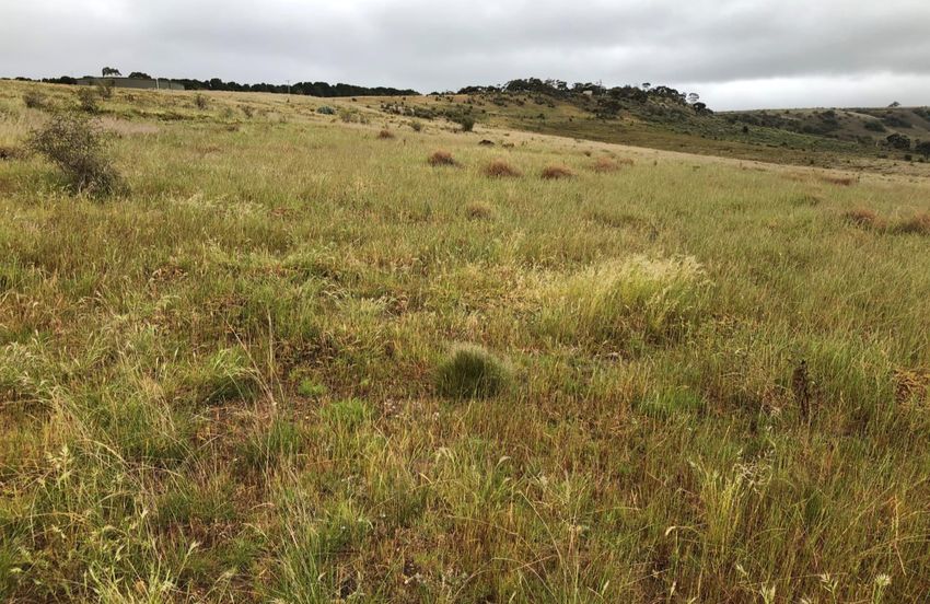
derived native grassland recorded (Figure 2). The patches were dominated by native grasses, primarily Rough
Spear-grass Austrostipa scabra and Wallaby-grass Rytidosperma spp., ranging in cover from 40-70% (Plate 1;
Plate 2). Additional native species were present in the patches in low cover, such as Windmill Grass Chloris
truncata, Ruby Saltbush Enchylaena tomentosa subsp. tomentosa and Berry Saltbush Atriplex semibaccata.
Plate 1. Rough Spear-grass creating a patch of native Plate 2. Wallaby-grass within a Plains Woodland patch
vegetation within the study area (Ecology and Heritage within the study area (Ecology and Heritage Partners
Partners Pty Ltd 13/10/2020). Pty Ltd 13/10/2020).
14
Stage 26 – 29 Stonehill Development: Biodiversity Assessment, Victoria3.1.2 Large Trees in Patches
No large trees in native vegetation patches were recorded within the study area.
3.1.3 Scattered Trees
Two large and three small scattered trees were recorded within the study area (Table 3).
Table 3. Summary of scattered trees recorded within the study area.
Tree ID Common name Scientific name DBH* Size Removed/Retained
1 Melbourne Yellow Gum Eucaluptus leucoxylon subsp. connata 42 Small Retained
2 Buloke Allocasuarina luehmannii 39 Small Retained
3 Buloke Allocasuarina luehmannii 51 Large Removed
7 Buloke Allocasuarina luehmannii 51 Large Removed
18 Blackwood Acacia melanoxylon 27 Small Removed
* DBH = Diameter at Breast Height (1.3 meters above ground level).
3.1.4 Introduced and Planted Vegetation
Areas not supporting native vegetation had a high cover (>90%) of exotic grass species, with large portions of
the study area subject to ploughing activities through past land use. Scattered native grasses were generally
present in these areas, however they did not have the required 25% relative cover to be considered a patch.
Non-native areas were dominated by environmental weeds such as Rye-grass Lolium spp., Barley Hordeum
vulgare, Galenia Galenia pubescens var. pubescens, Ribwort Plantago lanceolata, and Wild Oat Avena fatua
(Plate 3).
Noxious weeds were present within the study area, with Artichoke Thistle Cynara cardunculus, Paterson’s
Curse Echium plantagineum, African Boxthorn Lycium ferocissimum and Serrated Tussock Nassella trichotoma
present. African Boxthorn and Serrated Tussock are also Weeds of National Significance (WoNS), with Serrated
Tussock being common in disturbed areas of the study area (Plate 4).
15
Stage 26 – 29 Stonehill Development: Biodiversity Assessment, VictoriaPlate 3. Noxious weed, Artichoke Thistle, were Plate 4. Serrated Tussock dominates disturbed areas of
scattered in low numbers within the study area (Ecology the study area (Ecology and Heritage Partners Pty Ltd
and Heritage Partners Pty Ltd 13/10/2020). 13/10/2020).
3.2 Fauna Habitat
Much of the study area consists of paddocks which contain improved exotic pastures, likely to be used as a
foraging resource by common generalist bird species which are tolerant of modified open areas. Fauna
observed using this habitat included Australian Magpie Cracticus tibicen, Little Raven Corvus mellori, Welcome
Swallow Hirundo neoxena, Magpie-lark Grallina cyanoleuca, Willie Wagtail Rhipidura leucophrys, Common
Starling Sturnus vulgaris and Eurasian Skylark Alauda arvensis.
Patches of native grassland occur within the study area and vary in quality and floristic composition. Habitat
attributes of the native grassland are suitable for an array of common native fauna, including snakes, lizards,
skinks and grassland birds.
Areas of native grassland, particularly those with a high cover of Wallaby-grass and Spear Grass, provide
habitat for the nationally significant Golden Sun Moth Synemon plana. Further details on Golden Sun Moth
are provided in section 3.4.2.
3.3 Removal, Destruction or Lopping of Native Vegetation (the
Guidelines)
The below clearing scenario is based on the updated development plan provided by Townsville City Project
Pty Ltd on 6 May 2021. The development plan includes residential lots, open space areas, access roads and a
heritage area. A Buloke conservation area is proposed directly adjacent to the western boarder of the study
area, where a stand of Plains Woodland will be protected for conservation values.
3.3.1 Vegetation proposed to be removed
The study area is within Location 2, with 1.456 hectares of native vegetation proposed to be removed. Previous
removals within the past five years include a total of 5.225 hectares. As such, the permit application falls under
the Detailed assessment pathway (Table 4).
16
Stage 26 – 29 Stonehill Development: Biodiversity Assessment, VictoriaCondition scores for vegetation proposed to be removed are provided in Appendix 1.2.
Table 4. Removal of Native Vegetation (the Guidelines) (DELWP 2017).
Assessment pathway Detailed
Location Category 2
Total Extent (past and proposed) (ha) 6.680
Extent of past removal (ha) 5.225
Extent of proposed removal (ha) 1.456
Large Trees (scattered and in patches) to be removed (no.) 2
EVC Conservation Status of vegetation to be removed Endangered (Plains Woodland)
3.3.2 Offset Targets
The offset requirement for native vegetation removal is 0.310 General Habitat Units and two large trees.
A summary of proposed vegetation losses and associated offset requirements is presented in Table 5 and the
Native Vegetation Removal (NVR) report is presented in Appendix 3.
Table 5. Offset Targets.
General Offsets Required 0.310 General Habitat Units
Large Trees 2
Vicinity (catchment/council) Port Phillip and Westernport CMA / Moorabool Shire Council
Minimum Strategic Biodiversity Value* 0.444
*The minimum Strategic Biodiversity Value is 80% of the weighted average score across habitat zones where a General
offset is required.
3.4 Significance Assessment
3.4.1 Flora
The VBA contains records of four nationally significant and 53 State significant flora species previously
recorded within 10 kilometres of the study area (DELWP 2021d) (Figure 3). The PMST nominated an additional
13 nationally significant species which have not been previously recorded but have the potential to occur in
the locality (DAWE 2021) (Appendix 1.3).
One Listed flora species was recorded within the study area, Buloke, with a total of three scattered Buloke
present (Trees 2, 3 and 7, Figure 2). Further, one species, Melbourne Yellow Gum, listed as vulnerable on the
Advisory list of rare or threatened plans was present within the study area (DEPI 2014). One Buloke and the
Melbourne Yellow Gum are proposed to be retained within the study area (Figure 2). In addition, one species,
Fuzzy New Holland Daisy Vittadinia cuneata, protected under the FFG Act, and one species, Fragrant Saltbush
Rhagodia parabolica, listed as Rare on the Advisory list of rare or threatened plans were present within the
17
Stage 26 – 29 Stonehill Development: Biodiversity Assessment, Victoriastudy area (DEPI 2014) were present within the study area. Both these species are proposed to be retained
within the study area.
No additional nationally or state significant flora species were recorded within the study area during the field
assessment undertaken in October 2020. However, there are five VBA records of the nationally significant
Spiny Rice-flower Pimelea spinescens subsp. spinescens within 10 kilometres of the study area (Appendix 1.3).
Further, there are approximately 2,600 additional recent records of the species approximately eight kilometres
north-east of the study area, recorded by Ecology and Heritage Partners (Ecology and Heritage Partners Pty
Ltd 2017). Spiny Rice-flower can be difficult to detect during spring and summer seasons, due to the general
increase in surrounding biomass and lack of key features aiding in detection (i.e. flowering material). Spiny
Rice-flower flower during autumn and winter, making the species easier to detect due to the absence of other
flowering species during this time and lower biomass levels. As such, while the species has not been recorded
during previous general flora and fauna surveys, it is considered that there is a moderate likelihood of the
study area supporting Spiny Rice-flower (Appendix 1.3).
3.4.2 Fauna
The VBA contains records of eight nationally significant and 27 State significant fauna species previously
recorded within 10 kilometres of the study area (DELWP 2021d) (Figure 4). The PMST nominated an additional
13 nationally significant species which have not been previously recorded but have the potential to occur in
the locality (DAWE 2021) (Appendix 2.1).
One significant fauna species, Golden Sun Moth, was confirmed within the study area during the targeted
surveys. Details are provided below on the results of the targeted surveys. Habitat characteristics for one other
significant fauna species, Striped Legless Lizard Delma impar, was identified within the study area. A summary
of the likelihood of occurrence of Striped Legless Lizard is provided below. No additional significant fauna
species are considered likely to rely upon the habitat for foraging or breeding purposes, due to the modified
nature of the habitat and lack of important habitat features (i.e. waterbodies and large, hollow-bearing trees).
Golden Sun Moth Targeted Surveys
Prior to European settlement, Golden Sun Moth was widespread and relatively continuous throughout its
range, inhabiting grassy open woodlands and grassland, although it now mainly inhabits small isolated sites
(DSE 2004). The species is threatened by habitat loss, disturbance and fragmentation due to agricultural
expansion and urbanisation. Many populations are isolated and fragmented, impeding the ability of the
relatively immobile females to recolonise areas, thereby reducing the likelihood of genetic exchange (DSE
2004). Such populations are therefore vulnerable as there is little likelihood of recolonisation in the event of
a local extinction.
Targeted surveys were focused on areas of vegetation where there has generally been less disturbance (i.e.
not ploughed or dominated by exotic grasses). The surveys focused on the areas mapped as Plains Woodland,
where patches were dominated by Spear-grass and Wallaby-grass. Whilst Golden Sun Moth have previously
been recorded elsewhere in degraded grasslands dominated by Chilean Needle-grass Nassella neesiana (a
Weed of National Significance) (DEWHA 2009), areas supporting Chilean Needle-grass were absent from the
study area. That is, the only areas that supported the species preferred food plants were the patches of Plains
Woodland.
18
Stage 26 – 29 Stonehill Development: Biodiversity Assessment, VictoriaA total of 15 Golden Sun Moth were recorded within the south-eastern corner of the study area, where
patches of Plains Woodland, present in a derived native grassland state, were recorded. Furthermore, a total
of 1.02 hectares of confirmed Golden Sun Moth habitat was present within the study area. A summary of the
targeted survey results is provided in Table 6 below.
Table 6. Summary of Golden Sun Moth weather conditions and survey results.
Wind No. of
Temperature Cloud
Date Survey times Reference Site* days No. GSM
(oC) (km/hr) cover (%)
since rain
15 km/hr
24/11/2020 11:00 – 12:00 Balliang 24.1 10% 2 0
N
17 km/hr
04/12/2020 13:30 – 14:30 Balliang 23.4 5% 5 10
SE
29 km/hr
14/12/2020 14:00 – 15:00 Balliang 31.2 5% 4 5
SW
Striped Legless Lizard
The VBA contains no previous records of Striped Legless Lizard within 10 kilometres of the study area (DELWP
2021d) (Appendix 2.1; Figure 4). The nearest record of Striped Legless Lizard is 12.5 kilometres north of the
study area, recorded in 2016 adjacent to Pyrites Creek (DELWP 2021a). The species is a grassland specialist
although may be associated with exotic vegetation and areas of grassy woodland habitat (TSSP 2016). Ecology
and Heritage Partners has undertaken numerous targeted surveys for Striped Legless Lizard throughout the
Bacchus Marsh area and have not detected the species within areas of remnant grassland or habitats which
support native tussock species (that are derived from grassy woodland habitats) (Ecology and Heritage
Partners Pty Ltd 2018b, 2017, 2013).
Due to the habitat conditions present and absence of records of this species in the local area it is considered
unlikely that an extant population of the species occurs within the study area. Therefore, targeted surveys for
the species are not considered warranted and have not been undertaken within the study area.
3.4.3 Ecological Communities
Five nationally listed ecological communities are predicted to occur within 10 kilometres of the study area
(DAWE 2021).
• Grassy Eucalypt Woodland of the Victorian Volcanic Plain;
• Grey Box (Eucalyptus microcarpa) Grassy Woodlands and Derived Native Grasslands of South-eastern
Australia;
• Natural Temperate Grassland of the Victorian Volcanic Plain;
• Seasonal Herbaceous Wetlands (Freshwater) of the Temperate Lowland Plains; and
• White Box-Yellow Box-Blakely's Red Gum Grassy Woodland and Derived Native Grassland.
19
Stage 26 – 29 Stonehill Development: Biodiversity Assessment, VictoriaHowever, vegetation within the study area did not meet the condition thresholds that define any national or
State-significant communities due to the absence of key indicator species (e.g. a eucalypt canopy or diverse
native understory), the low diversity of native flora and high cover of exotic vegetation.
20
Stage 26 – 29 Stonehill Development: Biodiversity Assessment, Victoria4 LEGISLATIVE AND POLICY IMPLICATIONS
4.1 Environment Protection and Biodiversity Conservation Act 1999
(Commonwealth)
The EPBC Act establishes a Commonwealth process for the assessment of proposed actions likely to have a
significant impact on any matters of National Environment Significance (NES).
Table 7. Potential impacts to matters of National Environmental Significance (NES)
Matter of NES Potential Impacts
World Heritage properties The proposed action will not impact any properties listed for World Heritage.
National heritage places The proposed action will not impact any places listed for national heritage.
Ramsar wetlands of international The proposed action will not impact any Ramsar wetlands of international
significance significance.
One nationally significant fauna species, Golden Sun Moth (GSM), was recorded
within the study area, with 1.02 hectares of confirmed GSM habitat present within
the study area.
Threatened species and ecological
One nationally significant flora, Spiny Rice-flower, has the potential to occur within
communities
the study area.
Native vegetation within the study area did not meet the condition thresholds that
define any nationally significant ecological communities.
While a number of species may occasionally fly the study area, it would not be
Migratory and marine species classed as an ‘important habitat’ as defined under the EPBC Act Policy Statement
1.1 Principal Significant Impact Guidelines (DoE 2013).
Commonwealth marine area The proposed action will not impact any Commonwealth marine areas.
Nuclear actions (including uranium mining) The proposed action is not a nuclear action.
Great Barrier Reef Marine Park The proposed action will not impact the Great Barrier Reef Marine Park.
Water resources impacted by coal seam gas
The proposed action is not a coal seam gas or mining development.
or mining development
4.1.1 Implications
Spiny Rice-flower
One nationally significant flora species, Spiny Rice-flower, has the potential to occur within the study area.
Targeted surveys are recommended to determine the presence of the species. Surveys should be undertaken
during April – August, during the known flowering period for the species.
Golden Sun Moth
A total of 1.02 hectares of confirmed Golden Sun Moth habitat was present within the study area, 0.91
hectares of which is proposed to be removed. 0.11 hectares of Golden Sun Moth habitat will be retained as it
falls within a retained area of cultural heritage significance.
21
Stage 26 – 29 Stonehill Development: Biodiversity Assessment, VictoriaAn assessment against the Significant Impact Thresholds for the critically endangered Golden Sun Moth
Synemon plana (DEWHA 2009) is included below (Table 8).
Table 8. Significant Impact Thresholds for the Golden Sun Moth
Ecological Element Affected Impact Threshold Comment
Given the total Golden Sun Moth
Large or contiguous habitat area (>10 Habitat loss, degradation or habitat within the study area is 1.02
hectares) fragmentation > 0.5 hectares hectares, this impact threshold does
not apply.
A total of 1.02 hectares of confirmed
Golden Sun Moth habitat was present
within the study area, 0.91 hectares of
which is proposed to be removed.
These small areas of habitat are likely
to suffer significant impacts from loss,
degradation and fragmentation as a
Small or fragmented habitat area (this habitat will not fragment the existing population (DEWHA 2009a), but rather, result in a reduction of
extent of the population at a local level by 0.91 hectares only.
However, a referral to the Commonwealth Environment Minister is recommended to assess the potential
impacts to Golden Sun Moth.
4.2 Flora and Fauna Guarantee Act 1988 (Victoria)
The FFG Act is the primary legislation dealing with biodiversity conservation and sustainable use of native flora
and fauna in Victoria. Proponents are required to apply for an FFG Act Permit to ‘take’ threatened and/or
protected flora species, listed vegetation communities and listed fish species in areas of public land (e.g. within
road reserves, drainage lines and public reserves/parks). An FFG Act permit is generally not required for
removal of species or communities on private land, or for the removal of habitat for a listed terrestrial fauna
species.
4.2.1 Implications
One species, Buloke, Listed under the FFG Act was recorded within the study area. In addition, one species,
Fuzzy New Holland Daisy, protected under the FFG Act was recorded within the study area. As the study area
occurs within private land, a permit under the FFG Act is not required. No FFG species were recorded along
the road reserve of McCormacks road reserve.
4.3 Planning and Environment Act 1987 (Victoria)
The Planning and Environment Act 1987 outlines the legislative framework for planning in Victoria and for the
development and administration of planning schemes. All planning schemes contain native vegetation
provisions at Clause 52.17, which require a planning permit from the relevant local Council to remove, destroy
or lop native vegetation, unless an exemption at Clause 52.17-7 on the Victoria Planning Provisions applies.
4.3.1 Local Planning Scheme
The study area is located within the Moorabool Shire Council and zoned General Residential Zone – Schedule
2 with one overlay present, a Development Plan Overlay – Schedule 3 (DELWP 2021e).
4.3.2 The Guidelines
The State Planning Policy Framework and the decision guidelines at Clause 12.01 Biodiversity and Clause 52.17
Native Vegetation require Planning and Responsible Authorities to have regard for the Guidelines (DELWP
2017).
4.3.3 Implications
The study area is within Location 2, with 1.456 hectares of native vegetation proposed to be removed. Previous
removals within the past five years include a total of 5.225 hectares. As such, the permit application falls under
the Detailed assessment pathway.
The offset requirement for native vegetation removal is 0.310 General Habitat Units and two large trees.
23
Stage 26 – 29 Stonehill Development: Biodiversity Assessment, VictoriaA planning permit from the Moorabool Shire Council is required to remove, destroy or lop any native
vegetation under Clause 52.17 of the Planning Scheme. In this instance, the application is required to be
referred to DELWP due to being within the detailed assessment pathway.
4.4 Catchment and Land Protection Act 1994 (Victoria)
Four weeds listed as noxious under the Catchment and Land Protection Act 1994 were recorded during the
assessment; Artichoke Thistle, Paterson’s Curse, African Boxthorn and Serrated Tussock. Similarly, there is
evidence that the study area is currently occupied by several pest fauna species listed under the CaLP Act;
European Rabbit Oryctolagus cuniculus and Red Fox Vulpes vulpes. A Weed and/or Pest Management Plan may
be required.
24
Stage 26 – 29 Stonehill Development: Biodiversity Assessment, Victoria5 MITIGATION MEASURES
5.1 Avoid and Minimise Statement
Given the nature of the proposed development as predominately a residential estate, it is not possible to avoid
all impacts to native vegetation within the study area. The majority of the study area contains exotic vegetation
modified through past agricultural land use, with native vegetation present along the southern boundary
where the study area rises up on a rocky rise.
A small section of Plains Woodland will be retained as it falls within a retained area of cultural heritage
importance, and two scattered trees, one Buloke and one Melbourne Yellow Gum, will be retained (Figure 2).
Further, the overall masterplan for the Stonehill development included a conservation area, which is located
directly west of Stages 26-29, where a Buloke woodland is retained, present along an escarpment.
In the context of the development, the modified condition of ecological values proposed to be impacted, and
the extent of native vegetation proposed to be retained and enhanced within the study area, it is considered
that the minimisation measures implemented are appropriate in this instance.
5.2 Best Practice Mitigation Measures
Recommended measures to mitigate impacts upon terrestrial values present within the study area may
include:
• Minimise impacts to native vegetation and habitats through construction and micro-siting techniques,
including fencing retained areas of native vegetation. If indeed necessary, trees should be lopped or
trimmed rather than removed;
• All contractors should be aware of ecologically sensitive areas to minimise the likelihood of
inadvertent disturbance to areas marked for retention. Native vegetation (areas of sensitivity) should
be included as a mapping overlay on any construction plans;
• Where possible, construction stockpiles, machinery, roads, and other infrastructure should be placed
away from areas supporting native vegetation; and,
• As indigenous flora provides valuable habitat for indigenous fauna, it is recommended that any
landscape plantings that are undertaken as part of the proposed works are conducted using
indigenous species sourced from a local provenance, rather than exotic deciduous trees and shrubs.
5.3 Offset Impacts and Strategy
According to DELWPs Native Vegetation Offset Register (DELWP 2021f), there are 24 offset sites within the
Port Phillip and Westernport CMA or Moorabool Shire Council region that can be used to satisfy the General
Habitat Unit offset requirements.
An offset register search statement identifying the relevant offsite sites is provided in Appendix 4.
25
Stage 26 – 29 Stonehill Development: Biodiversity Assessment, Victoria6 FURTHER REQUIREMENTS
Further requirements associated with development of the study area, as well as additional studies or reporting
that may be required, are provided in Table 9.
Table 9. Further requirements associated with development of the study area.
Relevant Legislation Implications Further Action
Spiny Rice-flower
One nationally significant flora species, Spiny Rice-
flower, has the potential to occur within the study area. Conduct targeted surveys for Spiny
Targeted surveys are recommended to determine the Rice-flower to determine presence
presence of the species. Surveys should be undertaken within the study area.
Environment Protection during April – August, during the known flowering
and Biodiversity period for the species. Prepare and submit a referral to the
Conservation Act 1999 Commonwealth Environment
A total of 1.02 hectares of confirmed Golden Sun Moth Minister at DAWE for impacts to
habitat was present within the study area, 0.91 Golden Sun Moth (and potentially
hectares of which is proposed to be removed. A referral Spiny Rice-flower).
to the Commonwealth Environment Minister is
recommended to assess the potential impacts to
Golden Sun Moth.
One species, Buloke, Listed under the FFG Act was
recorded within the study area. In addition, one
species, Fuzzy New Holland Daisy, protected under the
Flora and Fauna FFG Act was recorded within the study area. As the
No further action required.
Guarantee Act 1988 study area occurs within private land, a permit under
the FFG Act is not required. No FFG species were
recorded along the road reserve of McCormacks road
reserve.
The study area is within Location 2, with 1.456 hectares
of native vegetation proposed to be removed. Previous
removals within the past five years include a total of
5.225 hectares. As such, the permit application falls
under the Detailed assessment pathway.
Planning and Environment The offset requirement for native vegetation removal Prepare and submit a Planning
Act 1987 is 0.310 General Habitat Units and 2 Large Trees. Permit application.
A planning permit from the Moorabool Shire Council is
required to remove, destroy or lop any native
vegetation under Clause 52.17 of the Planning Scheme.
In this instance, the application is required to be
referred to DELWP.
Four weed species listed under the CaLP Act were
recorded within the study area (Artichoke Thistle,
Planning Permit conditions may
Catchment and Land Paterson’s Curse, African Boxthorn and Serrated
include a requirement for a Weed
Protection Act 1994 Tussock). To meet requirements under the CaLP Act,
and/or Pest Management Plan.
listed noxious weeds should be appropriately
controlled throughout the study area.
26
Stage 26 – 29 Stonehill Development: Biodiversity Assessment, VictoriaREFERENCES
ALA 2020. Atlas of Living Australia. URL: https://www.ala.org.au/. Atlas of Living Australia, Canberra, ACT.
Clarke, G.M. & C. O'Dwyer 1999. Further survey in southeastern New South Wales for the endangered golden
sun moth, Synemon plana. Pg 77. CSIRO Entomology, Canberra.
DAWE 2021. Protected Matters Search Tool. [www Document] URL:
http://www.environment.gov.au/epbc/pmst/index.html. Commonwealth Department of Agriculture,
Water and the Environment, Canberra, ACT.
DELWP 2017. Guidelines for the removal, destruction or lopping of native vegetation. December 2017.
Victorian Department of Environment, Land, Water and Planning, Melbourne, Victoria.
DELWP 2018. Assessor’s handbook: Applications to remove, destroy or lop native vegetation. October 2018.
Victorian Department of Environment, Land, Water and Planning, Melbourne, Victoria.
DELWP 2019a. Flora and Fauna Guarantee Act 1988 Threatened List – November 2019 [www Document]. URL:
https://www.environment.vic.gov.au/__data/assets/pdf_file/0024/115827/20191114-FFG-
Threatened-List.pdf. Victorian Department of Environment, Land, Water and Planning, Melbourne,
Victoria.
DELWP 2019b. Flora and Fauna Guarantee Act 1988 Protected Flora List – November 2019 [www Document].
URL: https://www.environment.vic.gov.au/__data/assets/pdf_file/0011/50420/20191114-FFG-
protected-flora-list.pdf. Victorian Department of Environment, Land, Water and Planning, Melbourne,
Victoria.
DELWP 2019c. Flora and Fauna Guarantee Act 1988 Threatened List – Characteristics of Threatened
Communities [www Document]. URL:
https://www.environment.vic.gov.au/__data/assets/pdf_file/0018/50418/04072019-Flora-and-Fauna-
Guarantee-Characteristics-of-Threatened-Communities-3.pdf. Victorian Department of Environment,
Land, Water and Planning, Melbourne, Victoria.
DELWP 2021a. NatureKit Map [www Document]. URL:
https://maps2.biodiversity.vic.gov.au/Html5viewer/index.html?viewer=NatureKit. Victorian
Department of Environment, Land, Water and Planning, Melbourne, Victoria.
DELWP 2021b. Native Vegetation Information Management Tool [www Document]. URL:
https://nvim.delwp.vic.gov.au. Victorian Department of Environment, Land, Water and Planning,
Melbourne, Victoria.
DELWP 2021c. Ecological Vegetation Class (EVC) Benchmarks for each Bioregion [www Document]. URL:
https://www.environment.vic.gov.au/biodiversity/bioregions-and-evc-benchmarks. Victorian
Department of Environment, Land, Water and Planning, Melbourne, Victoria.
DELWP 2021d. Victorian Biodiversity Atlas. Sourced from GIS layers: “VBA_FLORA25”, “VBA_FLORA100”,
“VBA_FAUNA25”, “VBA_FAUNA100”. October 2020. Victorian Department of Environment, Land, Water
and Planning, Melbourne, Victoria.
27
Stage 26 – 29 Stonehill Development: Biodiversity Assessment, VictoriaYou can also read