Habitat Selection of Wintering Birds in Farm Ponds in Taoyuan, Taiwan - MDPI
←
→
Page content transcription
If your browser does not render page correctly, please read the page content below
animals
Article
Habitat Selection of Wintering Birds in Farm Ponds in
Taoyuan, Taiwan
Chia-Hsuan Hsu 1 , Jui-Yu Chou 2 and Wei-Ta Fang 3, *
 1   School of Forestry and Resource Conservation, National Taiwan University, Taipei City 10617, Taiwan;
     d05625002@ntu.edu.tw
 2   Department of Biology, National Changhua University of Education, Changhua City 50007, Taiwan;
     jackyjau@cc.ncue.edu.tw
 3   Graduate Institute of Environmental Education, National Taiwan Normal University,
     Taipei City 11606, Taiwan
 *   Correspondence: wtfang@ntnu.edu.tw; Tel.: +886-2-7734-6558; Fax: +886-2-2933-6947

 Received: 2 February 2019; Accepted: 21 March 2019; Published: 23 March 2019

 Simple Summary: Identification of existing and potential irrigation ponds is essential for creating
 waterbird refuges to secure habitats for wintering waterbirds in anthropogenically influenced areas.
 In total, 45 ponds were surveyed in the Taoyuan Tableland in northwestern Taiwan. The association
 between pond dimensions and bird-species richness and community composition was determined by
 comparing the responses of functional groups to pond configurations. The results demonstrated that
 waterbirds, compared with landbirds, have a stronger correlation with pond variables. Our study
 provided substantial evidence that these artificial ponds had also influenced the distribution of
 wintering waterbirds.

 Abstract: Farm ponds or irrigation ponds, providing a vital habitat for diverse bird communities, are
 an environmental feature with characteristics that cross over typical urban and natural conditions.
 In this study, the species richness and community structure of irrigation ponds were characterized
 on the local and landscape scales. Within a landscape complex in the Taoyuan Tableland of Taiwan,
 45 ponds were surveyed, ranging in areas from 0.2 to 20.47 ha. In total, 94 species and 15,053
 individual birds were identified after surveying four times. The association between ponds and
 birds was determined to establish the effect of pond dimensions on species richness and community
 composition in the complex by comparing the responses of functional groups to pond configurations.
 Seven avian functional groups were identified. Compared with landbirds (i.e., families Alcedinidae,
 Apodidae, Icteridae, and Sturnidae), waterbirds (i.e., families Anatidae, Ardeidae, Charadriidae,
 Podicipedidae, and Scolopacidae) exhibited a stronger correlation with pond variables. Our study
 provides substantial evidence that these artificial ponds have influenced wintering waterbirds.
 The final results of this study may help stakeholders and land managers identify areas not to establish
 large-scale solar facilities considering waterbird habitats in pond areas.

 Keywords: habitat difference; irrigation ponds; landscape ecology; wintering birds

1. Introduction
     Over the years, human activities have severely affected wildlife and its habitat; therefore, it is
crucial to balance the needs of people and wildlife. In particular, the habitats of birds are extensively
exploited by humans through the use of land and water for agriculture, associated construction,
and other types of development activities [1,2]. In Taoyuan Tableland, Taiwan, thousands of farm
ponds have been constructed for irrigation. This area had more than 3290 ponds in the 1970s, but fewer

Animals 2019, 9, 113; doi:10.3390/ani9030113                                    www.mdpi.com/journal/animals
Animals 2019, 9, 113 2 of 18
than 1800 currently exist. Farm pond configurations and the complexity of their compositions exhibit
marked diversity [3]. Pondscape was defined as “a series of water surfaces of ponds in association
with various surrounding landforms, including farms, creeks, canals, roads, houses, woodlands,
and other open spaces” [3–5]. Several migratory birds stop over at pondscapes. Because of their
specific habitat requirements for stopover during migration, birds provide indicators regarding habitat
conditions [6,7]. All avian species select a suitable habitat to ensure availability of food, water, shelter
from the weather and predators and feasible nesting sites to reproduce. All species in a guild display
similar characteristics. However, Duelli and Obrist suggested that generalist species might not be
appropriate biodiversity indicators [8].
Anthropogenic influences (i.e., pollution, destruction, degradation, and other stress) can be
monitored using bioindicators [9–11]. In this case, generalists are the ones that could benefit from a
higher abundance of habitats that are spatially heterogeneous. However, specialists are the ones that
thrive in a nearly homogenous habitat, with a high occurrence rate in their own specific habitat [12].
Thus, compared with generalists, specialists are less dependent on habitat scale and can only exist
within a specific type of habitat. These species include waterfowl (Anatidae and Podicipedidae),
shorebirds (Charadriidae and Scolopacidae), and wading birds (Ardeidae). They have specific
habitat requirements and are generally unable to adapt to new diets or environmental conditions [13].
Therefore, specialists are more vulnerable than generalists to anthropogenic disturbance [14,15].
The guild concept involves the division of birds according to their habitats and further
categorization according to landscape configurations. Root, the first avian scientist to propose the guild
concept, defined a guild as “a group of species that exploit the same class of environmental resources
in a similar way” [16]. He realized that the traditional taxonomic approach failed to categorize avian
communities appropriately. For example, he described the “foliage-gleaning guild” as birds that obtain
their food from foliage and occasionally from branches [16]. Thus, Root grouped five species with
similar diets, foraging locations, and feeding behaviors into one guild [16].
After Root defined functional groups based on traditional guilds (considering diets and foraging
strategies), other authors have followed his approach for investigating avian behavior and foraging
strategies [17–20]. Studies have evaluated nesting, resting, singing, residential locations [3,21–23],
foraging strategies, and singing locations [24]. However, most studies using functional groups have
grouped species according to subjective criteria or a single behavior, focused on a single group or
selected groups, at a single location or on small spatial scales [25,26].
Previous studies have also evaluated environmental conditions through examining guilds within
heterogeneous landscapes [12,27]. We selected the definition of a guild that uses habitat preference to
define functional groups [4]. Through categorization of birds as generalists or specialists, French and
Picozzi [4] demonstrated that wintering birds were influenced by land use. Avian grouping aids in
identifying avian diversity according to habitat, while tackling landscape complexity [28]. Because
information is limited regarding environmental factors that affect avian guilds, previous avian studies
have applied cluster analyses for the grouping of similar components of the avian community into
respective functional groups [29–31]. The previous study aimed to identify groups of birds with certain
habitat preferences by constructing groups (clusters) using multivariate data [30]. Both habitat- and
landscape-scale avian community studies are required to understand habitat selection [32,33].
On a larger scale, landscape configurations account for variations in the richness and diversity
of wintering bird species. An irrigation birds’ habitat can be evaluated according to the number of
avian species it contains. Therefore, birds become a bio-indicator for different types of habitat [34,35].
Differences in edge disturbance affect birds differently on avian communities. To preserve biodiversity
on different habitats and landscape scales, it is essential to understand the effects of different
management strategies on diversity.
Avian ecologists have used guilds to avoid classified errors that can occur when considering a
large number of species [36]. However, the taxonomic diversity of entire groups and specific guilds is
well debated [37]. One drawback of using guilds is that the taxonomic approach to avian studies is notAnimals 2019, 9, 113 3 of 18
commensurate with landscape scales [37]. Furthermore, studies using aggregate species richness or
diversity indices have often been oversimplified [38,39].
Although most of the farm ponds in Taoyuan are artificial, they provide food, refuge, and nesting
sites for breeding birds. Thus, farm pond ecosystems in Taoyuan are crucial for these birds.
Furthermore, farm ponds are wetlands for flood detention and water purification [40,41]. Farm
ponds are vital for humans as well. However, current developments, such as large-scale solar facilities,
in ponds tend to destroy pondscapes; therefore, we, ecologists and bird lovers, are actively trying to
protect these ponds. This study includes data from 2003 to 2004; our goal was to present bird conditions
before solar facility construction to inform decision-makers of the importance of ponds to wildlife.
In this study, we compared approaches for calculating species diversity in specific functional groups,
which helped select an approach for fitting avian communities in irrigation ponds. The purpose of this
study was to identify bird guilds through cluster analysis, simply list the birds recorded, organize them
into groups, and indicate those understood to be “generalists” or “specialists”. Therefore, this study
aimed to (1) characterize and analyze the waterbird species around the irrigation ponds of Taoyuan
and, (2) categorize their functional groups using cluster analysis, thereby grouping birds according
to different habitats. We did not study avian feeding habits (i.e., insect feeding, seed feeding, algae
feeding, fish or crustacean feeding) and their food; we instead focused only on the correlation between
guild (i.e., species richness and individuals) and pondscape variables.
2. Materials and Methods
2.1. Study Site
Birds were surveyed at 45 irrigation ponds in the Taoyuan Tableland, Taiwan, from November
2003 to February 2004 (24◦ 59’ N, 121◦ 18’ E) (Figure 1). Taoyuan receives a substantial amount of
precipitation (1849 mm/year); however, the majority of it is unevenly distributed throughout the
year [42]. The Taoyuan Tableland, located approximately 40 km southwest of Taipei, occupies an area
of 757 km2 . Taoyuan, which translates to peach garden in English, is situated in a rich agricultural
area that contained many peach orchards in the 19th century [42]. Therefore, ponds have been
created in this area to store rainwater (10,000 ponds at the peak). The primary function of these
ponds is irrigation for agricultural activities [43]. Because urban development has rapidly increased,
the Taoyuan metropolitan area now enjoys some of the fastest growth among the six metropolitan areas
of Taiwan [42]. Historically, pond sites were constructed on nonpermeable laterite soils containing
water. These ponds are also home for birds and other aquatic fauna [44]. Population pressure has
contributed to declines in historical areas of farmlands and farm ponds [45]. Losses of farm pond and
farmland habitats have severely affected a range of avian communities and other fauna and flora [43].
2.2. Sampling
To sample the entire community and account for birds having different degrees of mobility,
we used stratified random sampling methods suitable for different habitats within the ponds.
Data regarding birds were recorded using the point count and line transect methods outlined in the
Research and Management Techniques for Wildlife and Habitat published by the Wildlife Society [46].
All surveys were conducted by 45 experienced ornithologists commenced at the same time before sunrise,
and concluded at 10:00 am on the same day. Each pond was surveyed and coded for numbers of bird
species and individuals observed for 30 min by using a point-count approach. No surveys were conducted
on extremely windy or rainy days. To minimize the effects of bird-observer-identified bias, groups of three
or four observers rotated between ponds. The observers counted birds observed in any habitats. Birds
belonging to the families Apodidae (swifts) and Hirundinidae (swallows) were also included based on
counting birds in flight and the use of audible/auditory noises. A similar method, namely the line transect
method, involves searching or traveling along a given length and recording the number of birds seen and
heard within a specified study area. To assess flexibility and field scaling, we surveyed the study areaAnimals 2019, 9, 113 4 of 18
using the extensive network of footpaths that cover it. Therefore, avian observers could reach all irrigation
Animals 2019, 9 FOR PEER REVIEW 4 of 18
ponds and focus on the water surfaces, mudflats, banks, and vegetation characteristics of the habitats.
stratified
Thus, random
stratified sampling
random and point
sampling counts
and point associated
counts withwith
associated line transects werewere
line transects usedused
for this avian
for this avian
survey;nine
survey; ninesubregions
subregionsofofrandom
random samplings were sharply
sharply divided
dividedand andinvestigated
investigatedsimultaneously
simultaneously to
to count
count avian
avian species
species andand individuals
individuals to obtain
to obtain accurate
accurate results.
results.
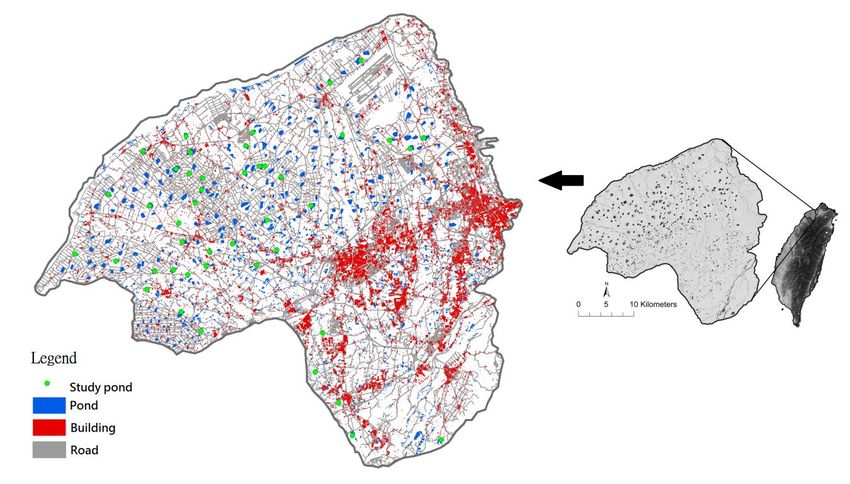
Studyarea
Figure1.1.Study
Figure areaininTaoyuan
Taoyuan Tableland,
Tableland, Taiwan.
Taiwan.
Surveys
Surveys were were conducted
conducted duringduringthe thenonbreeding
nonbreedingseason season ofof 2003–2004
2003–2004 when when deciduous
deciduous treestrees
were
werestill
stillininleaf
leaf in
in the
the subtropical
subtropical regionregionof ofTaiwan.
Taiwan.Birds Birdswere
were surveyed
surveyed fourfour times
times in ponds
in 45 45 ponds
simultaneously
simultaneously over 4 months from November 2003 through February 2004. For this survey,survey,
over 4 months from November 2003 through February 2004. For this 45
45experienced
experienced bird
bird observers
observers divided
divided intointo nine
nine subgroups
subgroups started
started their
their observation
observation before
before sunrise
sunrise
(07:00)
(07:00)and
andended
ended at 10:00
10:00 on onthe
thesame
samedate. date. Each
Each observer,
observer, trained
trained andand experienced
experienced in identifying
in identifying ≥
≥200200observable
observable species,
species, sampled
sampled all pond
all pond habitat
habitat types types equally
equally and rotated
and rotated into different
into different groupsgroups
in
inthe
thesubsequent
subsequent months
months to avoid
to avoid sampling
sampling bias.bias.
Stratified random
Stratified samples
random were used
samples wereforusedall for
45 all
45irrigation
irrigation ponds
ponds selected.
selected. EachEachpond pondwaswas surveyed
surveyed andandcodedcodedfor for
numbers
numbers of bird species
of bird andand
species
individuals within
individuals within 30 30 min
min using
using aa point
point count
countapproach.
approach.Furthermore,
Furthermore, totals
totals forfor
thethe
surrounding
surrounding
areasatataa564.19-m
areas 564.19-m basalbasal radius
radius fromfrom the thepond
pondgeometric
geometriccentercenter (a (a
100-ha
100-ha circle) were
circle) wereestimated
estimated
through the line transect method. The following environmental
through the line transect method. The following environmental factors were then considered:factors were then considered: pond pond
size (PS); foliage canopy area (FCA); mudflat area (MA); water
size (PS); foliage canopy area (FCA); mudflat area (MA); water surface area (WASA); the ratiosurface area (WASA); the ratio of of
farmland(%FARM);
farmland (%FARM); the the ratio
ratio ofof permanent
permanentbuilding buildingareaarea(%BUILD);
(%BUILD); thethe
ratio of multiple
ratio of multiple pond areas
pond areas
(%PONDS); the ratio of all watercourse areas covered by rivers, channels, and ditches (%RIVER); and
(%PONDS); the ratio of all watercourse areas covered by rivers, channels, and ditches (%RIVER); and
the ratio of all road and trail areas (%ROAD) within a radius of 100 ha from the pond’s geometric
the ratio of all road and trail areas (%ROAD) within a radius of 100 ha from the pond’s geometric center
center (Table 1). Other variables related to the degree of urbanization (e.g., human density,
(Table 1). Other variables related to the degree of urbanization (e.g., human density, transportation
transportation flow rate, number of automobiles, and number of tall buildings) were not considered
flow rate, number of automobiles, and number of tall buildings) were not considered because they
because they predominantly influenced species breeding in the urban matrix (e.g., the Eurasian tree
predominantly
sparrow, Passerinfluenced
montanus; species breeding bulbul,
the light-vented in the urban matrixsinensis;
Pycnonotus (e.g., theandEurasian
the Japanesetree sparrow,
white-eye, Passer
montanus; the light-vented bulbul, Pycnonotus sinensis; and the Japanese
Zosterops japonicus) that were recognized as generalists but not specialists within the water surface white-eye, Zosterops japonicus)
that were recognized
surrounding farm ponds. as generalists
In this case, but generalists
not specialists within
benefit fromthe water surface
environments surrounding
that are spatially farm
ponds. In this case,
heterogeneous, generalists
whereas benefit
specialists thrivefrom environments
in habitats that are that
almostarehomogenous.
spatially heterogeneous,
We, then, used whereas
the
specialists thrive in habitats that are almost homogenous. We, then,
geographic information system (ArcGIS 9, ESRI, Redlines, CA, USA) to collect the aforementioned used the geographic information
system (ArcGIS 9, ESRI, Redlines, CA, USA) to collect the aforementioned data [47].
data [47].
At
Atthe
the center
center of of each
eachselected
selectedpond,pond, a circle
a circle of 564.19
of 564.19 m inmradius
in radiuswas was
drawn drawn
withinwithin
an areaanofarea
of100
100ha,
ha,
andand thethe
covercover ratios
ratios of five
of five major major
land land use types
use types (ponds,(ponds, watercourses,
watercourses, farmlands, farmlands,
roads, androads,
constructions) and three habitat types (water surfaces, mudflats, and FCAs) were measured. The land
use plots were identified based on field surveys, a geographic aerial map (1:5000) of Taiwan, andAnimals 2019, 9, 113 5 of 18
and constructions) and three habitat types (water surfaces, mudflats, and FCAs) were measured.
The land use plots were identified based on field surveys, a geographic aerial map (1:5000) of Taiwan,
and aerial photographs (1:5000) from 2003. Pond elevations, perimeters, and built-up topologies of
waterfronts according to global positioning systems and field surveys were also measured. Information
on consolidated areas, as well as the distance from sources that contained the study sites, was derived
from the geographic aerial map (1:5000) of Taiwan. All environmental factors formed as patchiness
indices were calculated using spatial patterns from aerial photographs (1:5000) using the ArcGIS 9 and
FRAGSTATS (Amherst, MA, USA) software programs [48].
Table 1. Definition and description of metrics used in patch analysis of factors that influence
bird communities.
Item Acronym Pondscape Variables (Metrics/Units) Description
PS b Pond size 1 Pond size (m2 )
Foliage canopy area next to waterfront edge of a
FCA b Boundary delineation of disturbance
pond (m2 ) 1
MA a,b Mudflat area in a pond (m2 ) 1 Boundary delineation of disturbance
WASA a,b Water surface area in a pond (m2 ) 1 Boundary delineation of disturbance
%FCA b FCA ÷ PS 1
%MA b MA ÷ PS 1
The ratio of farmland areas within a radius of 100 ha Pondscape isolation or connectivity
%FARM b
from the pond’s geometric center (m2 )/ha 1 from the center of each selected pond
The ratio of permanent building areas within a radius Pondscape isolation from center of
%BUILD b
of 100 ha from the pond’s geometric center (m2 )/ha 1 each selected pond
The ratio of multiple pond areas within a radius of Pondscape connectivity from the
%PONDS b
100 ha from the pond’s geometric center (m2 )/ha 1 center of each selected pond
The ratio of all watercourse areas covered by rivers,
Pondscape connectivity from the
%RIVER b creeks, channels, and ditches within a radius of
center of each selected pond
100 ha from the pond’s geometric center (m2 )/ha 1
The ratio of all road and trail areas within a radius of Pondscape isolation from the center of
%ROAD b
100 ha from the pond’s geometric center (m2 )/ha 1 each selected pond
1 Mean values are expressed in percent. The different land use types were measured as a percentage area of a
circle with an area of 100 ha (radius = 564.19 m) centered on each of the survey ponds (n = 45). The range of the
percentage area of each land use type is also given. a Variable based on field measurements. b Variable based on the
GIS.; PS: pond size; FCA: foliage canopy area; MA: mudflat area; WASA: water surface area; %FARM: the ratio of
farmland; %PONDS: the ratio of permanent building area; the ratio of multiple pond areas; %RIVER: the ratio of all
watercourse areas covered by rivers, channels, and ditches; %ROAD: the ratio of all road and trail areas, within a
radius of 100 ha from the pond’s geometric center.
PS was determined from the official digital maps of the Department of Land Management, Ministry
of the Interior. The MA and WASA, which were considered to be areas for stopovers of migratory species
in farm ponds, were measured from aerial photographs (1:5000) and calibrated through field surveys.
The FCAs, which might function as corridors or stopovers, were also assessed through contour plots
around each pond and measuring the size of wooded areas on the map (1:5000). The same variables
were calculated for each of the 45 ponds using ArcGIS 9 and FRAGSTATS. Finally, we analyzed 180 cases
(four times each for 45 ponds, degrees of freedom = 179) using SPSS 24.0 (IBM, Armonk, NY, USA) [49].
Cluster analysis was used to identify relationships among the attributes of multivariate
samples [49]. The objective of cluster analysis is to group data into clusters, such as elements within
guilds [16]. The analysis encompassed a number of algorithms to group birds on the basis of similarities
or distance (dissimilarities) [50].
We used the Ward method to merge clusters of species when the nearest neighbor whose distance
reached to some groups. The most widespread hierarchical clustering method is the Ward method,
which considers the highest similarity [51]. The grouping and value of the error sum of squares (ESS) ofAnimals 2019, 9, 113 6 of 18
the vertical axis at which the mergers occur were clearly illustrated using a dendrogram. The number
below each linkage indicates the order in which each fusion occurred. The Ward method was applied
with the distance (dissimilarities) index. To avoid loss of information while joining two avian groups, the
Ward hierarchical clustering procedure, also known as the method of minimum variance, was adopted
to form data partitions to minimize the information loss associated with each grouping. The aim of the
Ward procedure is to determine, at each stage, two clusters that merge to provide the minimum increase
in the total within the group ESS [52]. Information loss was defined as an ESS criterion:
ni p
ESSi = ∑∑ xijk − xik (1)
j =1 k =1
where xijk is the multivariate measurement associated with the jth item, and xik is the mean of all items.
The total within group ESS, ESSi , is defined as one stage with k groups, j variables, and ni elements in
each group. Therefore, following the summation order, the first sum corresponds to the variability inside
a group for a given variable, the second sum is a sum of all variables, and the final sum represents the
total variability. The cluster analysis was performed using e SAS 8.0 for Windows [53].
3. Results
3.1. Classification of Guilds
The survey identified 94 species within 45 point count locations. In Taoyuan, 45 species (48%)
were wintering migrants, and 40 species (43%) were breeding residents. Five species were short-transit
species (5%) on the farm pond sites, one species (1%) was not present at the site and defined as a
“vagrant bird,” and three species (3%) were escaped individuals of domestic species. The total number
of species in the winter seasons in the study area varied from a low of 59 (February 2004) to a high of 67
(December 2003). We identified a greater species richness among wintering migrants (48%) compared
with permanent residents (45%). On a habitat scale, the individuals we observed most frequently were
those in and above the ponds and those on the edge of the ponds.
When surveying the frequencies of occurrence, we identified 10 species that had substantially
higher abundances than the other species, accounting for 74% of the total number of individuals
(Table 2). Nine of them were categorized as generalist species that could benefit from habitats that are
spatially heterogeneous with a higher abundance (see Table A1 in Appendix A). We also identified 84
other species, which accounted for 36% of the total. We detected 23 species with >100 individual birds
and 40 species withAnimals 2019, 9, 113 7 of 18
Farm
Animals 2019,ponds wereREVIEW
9 FOR PEER generally associated with the highest number of individuals, with several 7 of 18
species restricted to this habitat type. We classified the species into broad categories based on
selection,
habitat as described
selection, by functional
as described terms,
by functional guilds,
terms, andand
guilds, thethegroups
groupsofof species
species using similar
similar
environmentalresources
environmental resourceswithin
withinsimilar
similarperiods.
periods.Therefore,
Therefore,we wecalculated
calculatedthe
theoccurrence
occurrenceraterateof
ofeach
each
species by dividing
species dividingthethenumber
numberofof habitats present
habitats presentby by
the the
totaltotal
number of habitats
number in each
of habitats inpond
each (Table
pond
1). This
(Table 1).grouping was used
This grouping was for analyses
used because
for analyses the source
because pool sizes
the source were were
pool sizes represented by the
represented bytotal
the
number
total of species
number in the
of species inTaoyuan Tableland.
the Taoyuan Tableland.
Werecorded
We recorded9494 species
species when
when measuring
measuring the characteristics
the characteristics of the of the habitat,
habitat, whichbecould
which could broadlybe
broadly classified
classified accordingaccording to the occurrence
to the occurrence rates the
rates of where of where the birds
birds were weresuch
detected, detected, suchoverhead,
as flying as flying
overhead,
the water’sthe water’s
surface, surface,trails
mudflats, mudflats, trails and
and edges, edges, grasslands,
grasslands, bushlands,bushlands, and woodlands
and woodlands (see Table (see
A1
Appendix). The group and value of ESS of the vertical axis
in Appendix A). The group and value of ESS of the vertical axis merged in merged in Figure 2. The individual
The individual
numbersdetected
numbers detectedandandspecies
speciesrichness
richnessofofthe
theavian
avianguilds
guildsinineach
eachmonth
montharearepresented
presentedininTable
Table3.3.
Figure2.2.Dendrogram
Figure Dendrogramshowing
showingthetheclassification
classificationof
ofavian
aviandata.
data. The
The Ward
Wardmethod
methodwas wasused
usedwith
withthe
the
distance (dissimilarities) index in seven functional groups including 94 species in the study area.
distance (dissimilarities) index in seven functional groups including 94 species in the study area.
Table 3. Individual numbers and species richness of avian guilds in each month.
Table 3. Individual numbers and species richness of avian guilds in each month.
Classification November 2003 December 2003 January 2004 February 2004
Classification Nov. 2003 Dec. 2003 Jan. 2004 Feb. 2004
Aerial feeder 96 (5) 248 (7) 90 (6) 79 (4)
Aerial feeder
Waterfowl 96 (5)
85 (6) 248 (7)
209 (6) 90 (6)
157 (7) 79 (4)
132 (5)
Waterfowl
Shorebirds 85 (6)
240 (6) 209
261 (6)
(10) 157 (7)
212 (10) 132 (5)
94 (6)
Waterside birds
Shorebirds 2192
240(10)
(6) 1776(10)
261 (14) 1775(10)
212 (11) 1465 (15)
94 (6)
Grassland
Waterside birds
birds 31 (4)
2192 (10) 127(14)
1776 (3) 17759 (2)
(11) 12 (4)
1465 (15)
Bushland birds 233 (11) 213 (9) 354 (9) 296 (8)
Grassland birds
Woodland birds
31 (4)
844 (18)
127 (3)
1438 (18)
9 (2)
1303 (17)
12 (4)
1082 (17)
Bushland birds
Individual no. (species richness) 233 (60)
3721 (11) 213 (9)
4272 (67) 354 (9)
3900 (62) 296 (59)
3160 (8)
Woodland birds 844 (18) 1438 (18) 1303 (17) 1082 (17)
The individual numbers have been detected in each group; the value within parentheses. Brackets indicate the
Individual no. (species richness)
species richness. 3721 (60) 4272 (67) 3900 (62) 3160 (59)
The individual numbers have been detected in each group; the value within parentheses. Brackets
3.2. Habitat
indicateDifferences
the specieswith Classification of Guilds
richness.
According to the dendrogram for the 94 species, we categorized the habitats into seven guilds
3.2. Habitat Differences with Classification of Guilds
on the basis of the occurrence rate of avian communities. These guilds were classified according to
According to the dendrogram for the 94 species, we categorized the habitats into seven guilds
on the basis of the occurrence rate of avian communities. These guilds were classified according to
the dendrogram for similarities between 94 species in the study area (Appendix and Figure 2). If this
classification adopted low similarities (marked to a distance of 0.75), it could be divided into fourAnimals 2019, 9, 113 8 of 18
the dendrogram for similarities between 94 species in the study area (Appendix A and Figure 2).
IfAnimals 2019, 9 FOR PEER REVIEW
this classification adopted low similarities (marked to a distance of 0.75), it could be divided 8 of 18
into
four guilds:
guilds: waterfowl
waterfowl (9 species),
(9 species), shorebirds
shorebirds (14 species),
(14 species), waterside
waterside birdsbirds (22 species),
(22 species), and landbirds
and landbirds (49
(49 species). We categorized the likelihood of species occurrence into zones that extended
species). We categorized the likelihood of species occurrence into zones that extended from the from the
pond’s core to its edge. We observed that the (1) interior pond species (i.e., waterfowl and shorebirds),
pond’s core to its edge. We observed that the (1) interior pond species (i.e., waterfowl and shorebirds),
(2)
(2)wading
wadingspecies,
species,and
and(3)
(3)external
external pond
pond species (i.e., landbirds,
landbirds,the
thespecies
speciesdetected
detectedininhabitats
habitatssuch
such
asasgrasslands, bushlands, and woodlands)
grasslands, bushlands, and woodlands) were were dominant in their habitats (Figure 3).
in their habitats (Figure 3).
Figure3.3.Distribution
Figure Distributionpatterns
patterns of
of relatively
relatively dominant
dominant bird
bird species
speciesin
inpond
pondhabitats
habitatssuccessively
successivelyfrom
from
the pond’s core to adjacent areas.
the pond’s core to adjacent areas.
3.3.
3.3.Richness
Richnessand
andAbundance
Abundanceof
of Guilds
Guilds Associated
Associated with Environmental
Environmental Variables
Variables
The
The14 14species
species of of shorebirds demonstratedan
shorebirds demonstrated anincreasing
increasing trend
trend with
with increasing
increasing MAMA in ain a pond
pond (r
(r==0.364,
0.364,ppAnimals 2019, 9, 113 9 of 18
However, the cumulative individuals of waterside guilds increased with (1) PS (r = 0.272, p < 0.0001),
(2) FCA (r = 0.205, p < 0.01), (3) %PONDS (r = 0.189, p < 0.05), (4) %FARM (r = 0.169, p < 0.05), and (5)
WASA (r = 0.249, p < 0.01). Except in aerial feeders, the guild abundance of landbirds decreased with
increasing %ROAD within a radius of 100 ha from the pond’s geometric center in m2 /ha (r = −0.199,
p < 0.01).
Table 4. Pearson product–moment correlation coefficients indicating the coefficients between guild
species richness and pondscape variables.
Classification Aerial Feeders Waterfowl Shorebirds Waterside Birds Landbirds 1
PS −0.073 0.259 ** 0.102 0.224 ** −0.100
FCA −0.006 0.305 ** 0.140 0.226 ** 0.078
MA −0.076 0.406 ** 0.364 ** 0.021 −0.108
WASA −0.048 0.112 −0.043 0.236 ** −0.063
%FCA 0.022 −0.026 0.043 −0.185 ** −0.057
%MA −0.033 0.387 ** 0.408 ** 0.063 −0.094
%FARM −0.039 −0.104 0.006 0.208 ** 0.044
%BUILD 0.109 0.016 −0.059 −0.292 ** −0.028
%PONDS −0.197 ** 0.162 * 0.133 0.199 ** −0.145
%RIVER 0.172 * 0.163 * 0.039 −0.111 0.102
%ROAD 0.020 −0.057 −0.122 −0.052 −0.135
1 Landbirds: This group included grassland birds, bushland birds, and woodland birds, but not aerial feeders in
this case. * The correlation is statistically significant at the 0.05 significance level, two-tailed. ** The correlation is
statistically significant at the 0.01 significance level, two-tailed.
Table 5. Pearson product–moment correlation coefficients indicating the correlation between guild
species individuals and pondscape variables.
Classification Aerial Feeders Waterfowl Shorebirds Waterside Birds Landbirds 1
PS −0.059 0.193 ** 0.091 0.272 ** −0.059
FCA −0.002 0.503 ** 0.007 0.205 ** 0.140
MA −0.054 0.347 0.291 ** 0.114 −0.084
WASA −0.041 0.064 −0.024 0.249 ** −0.029
%FCA −0.034 −0.046 0.005 −0.120 −0.018
%MA −0.021 0.398 ** 0.367 ** 0.184 * −0.058
%FARM −0.091 −0.005 0.011 0.169 * 0.076
%BUILD 0.099 −0.069 −0.036 −0.237 ** −0.010
%PONDS −0.093 0.171 * 0.075 0.189 * −0.075
%RIVER 0.256 ** 0.095 −0.018 −0.117 −0.034
%ROAD 0.035 −0.151 * −0.064 −0.110 −0.199 **
1 Landbirds: This group included grassland birds, bushland birds, and woodland birds, but not aerial feeders in
this case. * The correlation is statistically significant at the 0.05 significance level, two-tailed. ** The correlation is
statistically significant at the 0.01 significance level, two-tailed.
4. Discussion
We compared wetland birds (i.e., waterfowl, shorebirds, and wading species) with landbirds
(i.e., woodland birds, bushland birds, and grassland birds) to analyze their associations with internal
and external pond variables, and the results demonstrated that the individual numbers of waterbirds
were more strongly correlated with the pond variables than were the landbirds. Guild analyses further
suggested that the principal factor affecting individual birds’ habitat selection was habitat availability.
Therefore, the potential for environmental effects on the bird community is high for waterbirds,
particularly waterside birds. For individual waterbirds to persist in the agricultural pondscape, fields
should have large areas and well-designed neighboring landscapes to support such birds.
Our study results indicated that different avian guilds respond differently to environmental
changes. In general, ponds with a larger area for wetland birds and wintering migratory birds could
sustain population increases. The associations between population sizes and carrying capacity for
individual numbers and species richness of a pond were moderate and slight, respectively, with pondsAnimals 2019, 9, 113 10 of 18
that support large concentrations of aerial feeders and landbirds as possible exceptions. However,
the point at which a pond is regarded as saturated by a single species can be determined by the
population sizes of other species wintering on those ponds. Our study results indicated a significant
positive correlation between species richness and abundance in several guilds of waterbirds.
In this study, we compared the species-area relationships in ecological groups with similar
source pool sizes. These analyses restricted the guild sizes to reduce the possibility of confounding
habitat effects. The absence of a habitat of a suitable size was likely a key factor leading to the poor
responses of some species in the selection of their wintering ponds. The entire habitats included
WASA, MA, and FCA. The waterbirds dependent on large habitat sizes increased in number in more
spatially heterogeneous areas, probably as a result of increased safety and food supply. However, other
environmental factors, such as the presence of predators and availability of food may also have altered
the habitat preferences of waterbirds in the study area.
First, we observed that the species richness and abundance of the wading birds were associated
with PS. The total species richness and number of individual waterside birds increased with increasing
PS. Second, we observed that individual waterfowl were correlated with the FCA because these
specialists or interior species were more sensitive to disturbance than generalists or edge species.
Migrants (family Anatidae) and residents (family Podicipedidae) tended to be more sensitive.
We discovered that their habitats are far away from the road, farm, or other nonwater regimes.
They appeared to be influenced by the level of human disturbance, PS, windbreak size, and pond
edge length.
Compared to previous work, we found our study reveal similar result is different pond factors
such as depth, size, and vegetation would influence the bird assemblages [54]. Our study is similar in
terms of findings with Froneman et al. (2001), they surveyed 59 farm ponds and found 44 bird species
in the Elgin and Caledon districts of the Western Cape, South Africa [5]. Compared to their study,
we found 94 species in Taoyuan Tableland. Thus, this shows that the farm ponds in Taoyuan are really
important for the wintering birds. Besides, the same result is that they found the surface area of the
farm ponds as an important variable determining the presence and abundance of many waterbird
species [5]. Different from their study, our study included the human structure and found near the
buildings and roads, the bird counts and diversity decreased. Anyway, the most important conclusion
is that we totally agree artificial waterbodies can play as alternative refuges for biodiversity [55–59].
In our study, we expected to observe the area per se hypothesis within an intermediate range of
areas but not at all spatial scales. On a small spatial scale, the species–area relationship is not governed
by an equation but is curvilinear on a log-log plot. On a landscape scale, the species-area relationship
bends upward toward a limiting slope of unity [60]. We realized that the habitat preferences of birds
with different lifestyles must be considered when determining habitat suitability. Most species in small
patches associated with the surrounding landscape are generalists, choosing between major habitats
and edge habitats. In large patches, the specialists select only interior habitats [61,62]. Therefore,
the spatially and taxonomically different species differ in their size [63]. Different avian communities
are likely to yield different land-use patches.
In this study, we compared the species-pondscape relationships among ecological groups with
their surrounding areas. We restricted these analyses to guild pool sizes to limit the confounding
effects of areas. The variables of local determinants of community structures were associated with the
amount of farmlands as well as the amount of urban environments. Low-rise residential houses and
high-density apartments were observed to affect species richness.
Waterside bird richness displayed a correlation with %BUILD within a radius of 100 ha from
the pond’s geometric center because the specialists detected from the pond’s core to the waterfront
were more sensitive to anthropogenic disturbance than generalists (i.e., landbirds) were (Table 4).
The wading bird species displayed a correlation with %FARM within a radius of 100 ha from the
pond’s geometric center. The richness of the waterside bird guild was correlated negatively with
increasing urbanization level (indicated by %BUILD); however, the richness correlated positively withAnimals 2019, 9, 113 11 of 18
increasing green spaces (i.e., farmlands and grasslands). Because we combined environmental factors
such as water and edge species of different sizes, foraging modes, and trees from the pond’s core to
the waterfront, it is likely that the increase in anthropogenic areas was the principal reason for their
decline. In addition, the farmlands, which might translate to greater insect abundance, were strongly
correlated with wading bird abundance.
Investigators extensively debated the field domains of the area per se hypothesis and
species–habitat hypothesis [64]. However, the generalized principles of ecological designs have yet to
be determined, and there is no final consensus on which species-habitat hypothesis is more relevant.
As described, birds respond to food and roost sites during habitat selection. The numbers of individual
birds of a particular species have been correlated with the requirements for grasslands, mudflats, open
shorelines, and canopies or water surfaces for horizontal heterogeneity [65,66]. Therefore, bird-habitat
relationships result from the responses of birds using habitats for different activities, such as foraging,
molting (i.e., that of the mute swan and greylag goose) [67,68], and roosting in winter. Birds can select
pondscape configurations according to their preference.
In this study, the irrigation pond areas were dominated by fields separated by hedgerows and
windbreaks, and woods of various sizes were scattered in these areas. The distributions of avian species
within such mosaic landscapes were discontinuous, depending on the preferred habitat locations,
density-dependent processes, and quality of individual patches. These configurations are surrounded
by built-up areas, rivers, roads, and farmlands. In our pondscape evaluations, we used the selected
parameters to measure the spatial arrangement of wooded and aquatic landscapes as well as to evaluate
the significance of their differences. Previous studies have used these parameters to measure temporal
changes in actual landscapes and changes in intensively used landscapes [69,70]. Increasing the pond
area increases the pond core area, thereby benefiting specialist species by enhancing the population
persistence associated with water depth, water level fluctuation, vegetation, salinity, topography,
food type, food accessibility, size, and connectivity [14,15,19]. Our results indicated a requirement for
relevant conservation scenarios to focus on vulnerable sites, which might be targeted for enlargement
by habitat creation at their woody edges, on the basis that large pond habitats are broadly beneficial
for biodiversity. Thus, we suggest a study on yearly or interannual variability of wintering waterbirds
to analyze the effect of habitat changes on birds.
5. Conclusions
To construct waterbird refuges in Taoyuan, Taiwan, for securing habitats for wintering waterbirds
in the areas of anthropogenic influence, existing and potential irrigation ponds must be identified.
Pond conservation for bird refuges is difficult because of increasing urban development, which exerts
pressure on avian communities [43,71]. Changes in land use [72], particularly consolidating farming
practices with urban construction, affect avian communities in ponds. Evaluating the pond habitats
of winter birds might provide useful information for simulating the pond environment to identify
the criteria of their habitat selection behaviors. On the habitat and landscape scales, specific selection
according to avian assemblages is required for identifying large areas within fields to support various
waterbird species.
The number of farm ponds in Taoyuan Tableland is decreasing, thus providing evidence of the
negative effects of landscape quality on the avian distribution and species in these fragmented habitats.
In our avian population studies, the functional groups associated with pondscape configurations
provided an effective tool for determining linear relationships based on the concept of landscape
ecology. We used theoretical models to quantify the influence of landforms on avian groups. Our study
provided substantial evidence that artificial ponds also influence wintering waterbirds. The final results
regarding ponds may aid stakeholders and land managers to identify areas for the establishment of
large-scale solar facilities in pond areas for superior management of wildlife. In conclusion, our study
provided a comprehensive view of farm pond-bird interaction in Taoyuan Tableland, thus aiding
decision-makers in enacting policies beneficial to both humans and the environment.Animals 2019, 9, 113 12 of 18
The results related to the condition of the birds at farm ponds in Taoyuan Tableland from 2003 to
2004. We, therefore, can compare the current condition of birds with that of 15 years ago for a better
understanding of the relationships of human activities and wildlife biodiversity.
Author Contributions: Conceptualization, C.-H.-H., J.-Y.C., and W.-T.F.; methodology, C.-H.-H.; software, J.-Y.C.;
validation, C.-H.-H. and W.-T.F.; formal analysis, J.-Y.C. and W.-T.F.; investigation, W.-T.F.; resources, W.-T.F.; data
curation, J.-Y.C.; writing—original draft preparation, C.-H.-H. and J.-Y.C.; writing—review and editing, C.-H.-H.,
J.-Y.C., and W.-T.F.; visualization, J.-Y.C. and W.-T.F.; supervision, W.-T.F.; project administration, W.-T.F.; funding
acquisition, J.-Y.C. and W.-T.F.
Funding: This research was funded by Ministry of Science and Technology (National Science Council),
grants (NSC99-2410-H-216-007, NSC100-2628-H-003-161-MY2, and NSC 102-2119-M-003-006 to W.-T. Fang;
NSC102-2311-B-018-001-MY2 to J.-Y. Chou) and the Wild Bird Society of Taoyuan.
Acknowledgments: We are grateful to four anonymous reviewers for constructive feedback and insightful
suggestions, which greatly improved this article. Our gratitude also goes to the Academic Paper Editing Clinic,
NCUE, and NTNU.
Conflicts of Interest: The authors declare no conflict of interest.Animals 2019, 9, 113 13 of 18
Appendix A
Table A1. List of birds detected in Taoyuan farm ponds and their occurrence rate in different habitats.
ID Code Common Name Scientific Name Air Waters Mudflats Trails Grasslands Bushlands Woodlands Avian Guilds
1 1402 Northern pintail Anas acuta 0.00 1.00 0.00 0.00 0.00 0.00 0.00 Waterfowl **
2 1403 Northern shoveller Anas clypeata 0.00 1.00 0.00 0.00 0.00 0.00 0.00 Waterfowl **
3 1404 Common teal Anas crecca 0.00 1.00 0.00 0.00 0.00 0.00 0.00 Waterfowl **
4 1408 Eurasian wigeon Anas penelope 0.00 1.00 0.00 0.00 0.00 0.00 0.00 Waterfowl **
5 1410 Spot-billed duck Anas poecilorhyncha 0.00 1.00 0.00 0.00 0.00 0.00 0.00 Waterfowl **
6 1419 Common pochard Aythya ferina 0.00 1.00 0.00 0.00 0.00 0.00 0.00 Waterfowl **
7 1523 Black-eared kite Milvus migrans lineatus 1.00 0.00 0.00 0.00 0.00 0.00 0.00 Aerial Feeder **
8 2102 Common coot Fulica atra 0.00 0.00 1.00 0.00 0.00 0.00 0.00 Shorebird **
9 2106 Ruddy-breasted crake Porzana fusca 0.00 0.00 1.00 0.00 0.00 0.00 0.00 Shorebird **
10 2608 Grey-headed lapwing Vanellus cinereus 0.00 0.00 1.00 0.00 0.00 0.00 0.00 Shorebird **
11 2609 Pacific golden plover Pluvialis fulva 0.00 0.00 1.00 0.00 0.00 0.00 0.00 Shorebird **
12 2738 Common redshank Tringa totanus 0.00 0.00 1.00 0.00 0.00 0.00 0.00 Shorebird **
13 2801 Black-winged stilt Himantopus himantopus 0.00 0.00 1.00 0.00 0.00 0.00 0.00 Shorebird **
14 2802 Pied avocet Recurvirostra avosetta 0.00 0.00 1.00 0.00 0.00 0.00 0.00 Shorebird **
15 4002 Fork-tailed swift Apus pacificus 1.00 0.00 0.00 0.00 0.00 0.00 0.00 Aerial Feeder **
16 4903 Striated swallow Hirundo striolata 1.00 0.00 0.00 0.00 0.00 0.00 0.00 Aerial Feeder **
17 4905 Plain sand martin Riparia paludicola 1.00 0.00 0.00 0.00 0.00 0.00 0.00 Aerial Feeder **
18 6701 Red-throated pipit Anthus cervinus 0.00 0.00 1.00 0.00 0.00 0.00 0.00 Shorebird **
19 2735 Common greenshank Tringa nebularia 0.00 0.00 0.97 0.03 0.00 0.00 0.00 Shorebird
20 1421 Greater scaup Aythya marila 0.00 0.95 0.00 0.00 0.00 0.00 0.05 Waterfowl
21 205 Little grebe Tachybaptus ruficollis 0.00 0.94 0.00 0.06 0.00 0.00 0.00 Waterfowl
22 2104 Common moorhen Gallinula chloropus 0.00 0.00 0.89 0.08 0.03 0.00 0.01 Shorebird
23 1409 Mallard Anas platyrhynchos 0.00 0.88 0.00 0.12 0.00 0.00 0.00 Waterfowl
24 4001 House swift Apus nipalensis 0.81 0.00 0.00 0.19 0.00 0.00 0.00 Aerial Feeder
25 2731 Wood sandpiper Tringa glareola 0.00 0.00 0.80 0.20 0.00 0.00 0.00 Shorebird
26 3207 Common black-headed gull Larus ridibundus 0.75 0.00 0.00 0.25 0.00 0.00 0.00 Aerial Feeder
27 2601 Kentish plover Charadrius alexandrinus 0.00 0.00 0.73 0.27 0.00 0.00 0.00 Shorebird
28 4904 Pacific swallow Hirundo tahitica 0.73 0.00 0.00 0.19 0.01 0.00 0.07 Aerial Feeder
29 2611 Northern lapwing Vanellus vanellus 0.00 0.00 0.72 0.28 0.00 0.00 0.00 Shorebird
30 2603 Little ringed plover Charadrius dubius 0.00 0.00 0.77 0.17 0.06 0.00 0.00 Shorebird *
31 1108 Great egret Casmerodius alba 0.00 0.59 0.00 0.34 0.00 0.00 0.07 Waterside bird *
32 4101 Common kingfisher Alcedo atthis 0.55 0.00 0.00 0.25 0.02 0.11 0.08 Aerial Feeder
33 4902 Barn swallow Hirundo rustica 0.53 0.00 0.00 0.47 0.00 0.00 0.00 Aerial Feeder
34 1706 Common kestrel Falco tinnunculus 0.50 0.00 0.00 0.00 0.00 0.00 0.50 Aerial FeederAnimals 2019, 9, 113 14 of 18
Table A1. Cont.
ID Code Common Name Scientific Name Air Waters Mudflats Trails Grasslands Bushlands Woodlands Avian Guilds
35 1111 Intermediate egret Mesophoyx intermedia 0.00 0.47 0.00 0.45 0.00 0.00 0.08 Waterside bird
36 1110 Little egret Egretta garzetta 0.00 0.54 0.00 0.28 0.01 0.04 0.13 Waterside bird *
37 2733 Common sandpiper Tringa hypoleucos 0.00 0.00 0.43 0.51 0.04 0.03 0.00 Waterside bird
38 1101 Grey heron Ardea cinerea 0.00 0.34 0.00 0.46 0.02 0.01 0.17 Waterside bird *
39 901 Common cormorant Phalacrocorax carbo 0.00 0.32 0.00 0.64 0.00 0.00 0.04 Waterside bird
40 2703 Dunlin Calidris alpina 0.00 0.00 0.28 0.72 0.00 0.00 0.00 Waterside bird
41 1121 Black-crowned night heron Nycticorax nycticorax 0.00 0.23 0.00 0.59 0.01 0.07 0.10 Waterside bird *
42 6707 White wagtail Motacilla alba 0.00 0.22 0.00 0.27 0.51 0.00 0.00 Grassland bird
43 5410 Black-billed magpie Pica pica 0.20 0.00 0.00 0.07 0.00 0.10 0.63 Woodland bird
44 1601 Osprey Pandion haliaetus 0.17 0.00 0.00 0.00 0.00 0.00 0.83 Woodland bird
45 5914 Rufous-capped babbler Stachyris ruficeps 0.00 0.14 0.00 0.14 0.00 0.00 0.71 Woodland bird
Streptopelia
46 3509 Red-collared dove 0.00 0.13 0.00 0.19 0.01 0.02 0.66 Woodland bird *
tranquebarica
47 6710 Yellow wagtail Motacilla flava 0.00 0.11 0.00 0.22 0.64 0.02 0.01 Grassland bird
48 5403 Large-billed crow Corvus macrorhynchos 0.00 0.11 0.00 0.28 0.00 0.00 0.60 Woodland bird
49 6708 Grey wagtail Motacilla cinerea 0.00 0.11 0.00 0.63 0.22 0.03 0.01 Waterside bird
Steak-breasted; Scimitar
50 5913 Pomatorhinus ruficollis 0.00 0.05 0.00 0.16 0.00 0.68 0.11 Bushland bird
babbler
51 5103 Black drongo Dicrurus macrocercus 0.00 0.05 0.00 0.29 0.19 0.14 0.34 Woodland bird
52 6313 Daurian redstart Phoenicurus auroreus 0.00 0.04 0.00 0.21 0.38 0.13 0.25 Woodland bird
53 6422 Plain prinia Prinia inornata 0.00 0.04 0.00 0.36 0.08 0.47 0.05 Bushland bird
54 7201 Japanese white-eye Zosterops japonica 0.00 0.03 0.00 0.03 0.01 0.10 0.84 Woodland bird *
55 3507 Spotted dove Streptopelia chinensis 0.00 0.02 0.00 0.21 0.08 0.00 0.68 Woodland bird
56 1105 Cattle egret Bubulcus ibis 0.00 0.02 0.00 0.21 0.00 0.01 0.77 Woodland bird
57 7012 White-vented myna Acridotheres grandis 0.00 0.02 0.00 0.53 0.00 0.00 0.45 Woodland bird
58 6003 Light-vented bulbul Pycnonotus sinensis 0.00 0.01 0.00 0.14 0.02 0.14 0.69 Woodland bird *
59 7601 Eurasian tree sparrow Passer montanus 0.00 0.01 0.00 0.23 0.04 0.21 0.51 Woodland bird *
60 1119 Yellow bittern Ixobrychus sinensis 0.00 0.00 0.00 0.00 1.00 0.00 0.00 Grassland bird
61 1802 Chinese bamboo partridge Bambusicola thoracica 0.00 0.00 0.00 0.00 1.00 0.00 0.00 Grassland bird **
Amaurornis
62 2101 White-breasted waterhen 0.00 0.00 0.00 1.00 0.00 0.00 0.00 Waterside bird **
phoenicurus
63 2707 Rufous-necked stint Calidris ruficollis 0.00 0.00 0.00 1.00 0.00 0.00 0.00 Waterside bird **
64 2709 Temminck’s stint Calidris temminckii 0.00 0.00 0.00 1.00 0.00 0.00 0.00 Waterside bird **
65 2713 Common snipe Gallinago gallinago 0.00 0.00 0.00 1.00 0.00 0.00 0.00 Waterside bird **
66 2729 Grey-tailed tattler Tringa brevipes 0.00 0.00 0.00 1.00 0.00 0.00 0.00 Waterside bird **
67 3508 Eastern turtle dove Streptopelia orientalis 0.00 0.00 0.00 0.05 0.00 0.03 0.91 Woodland bird
Woodland bird
68 3512 White-bellied green pigeon Treron sieboldii 0.00 0.00 0.00 0.00 0.00 0.00 1.00
**
69 3601 Lesser coucal Centropus bengalensis 0.00 0.00 0.00 1.00 0.00 0.00 0.00 Waterside bird **Animals 2019, 9, 113 15 of 18
Table A1. Cont.
ID Code Common Name Scientific Name Air Waters Mudflats Trails Grasslands Bushlands Woodlands Avian Guilds
Woodland bird
70 4501 Black-browed barbet Megalaima oorti 0.00 0.00 0.00 0.00 0.00 0.00 1.00
**
71 5407 Grey treepie Dendrocitta formosae 0.00 0.00 0.00 0.00 0.43 0.43 0.14 Bushland bird
72 5502 Vinous-throated parrotbill Paradoxornis webbianus 0.00 0.00 0.00 0.21 0.00 0.65 0.14 Bushland bird
Hypsipetes
73 6002 Black bulbul 0.00 0.00 0.00 1.00 0.00 0.00 0.00 Waterside bird **
leucocephalus
74 6307 Siberian rubythroat Luscinia calliope 0.00 0.00 0.00 0.33 0.00 0.67 0.00 Bushland bird
75 6317 Orange-flanked bush-robin Tarsiger cyanurus 0.00 0.00 0.00 0.00 0.00 1.00 0.00 Bushland bird **
76 6321 Brown-headed thrush Turdus chrysolaus 0.00 0.00 0.00 1.00 0.00 0.00 0.00 Waterside bird **
77 6325 Dusky thrush Turdus naumanni 0.00 0.00 0.00 1.00 0.00 0.00 0.00 Waterside bird **
Acrocephalus
78 6402 Great reed warbler 0.00 0.00 0.00 0.00 1.00 0.00 0.00 Grassland bird **
arundinaceus
79 6406 Japanese bush warbler Cettia diphone 0.00 0.00 0.00 0.33 0.00 0.00 0.67 Woodland bird
Brownish-flanked bush
80 6407 Cettia fortipes 0.00 0.00 0.00 1.00 0.00 0.00 0.00 Waterside bird **
warbler
81 6410 Zitting cisticola Cisticola juncidis 0.00 0.00 0.00 0.00 0.00 1.00 0.00 Bushland bird **
82 6421 Yellow-bellied prinia Prinia flaviventris 0.00 0.00 0.00 0.22 0.12 0.56 0.10 Bushland bird
83 6703 Olive-backed pipit Anthus hodgsoni 0.00 0.00 0.00 1.00 0.00 0.00 0.00 Waterside bird **
84 6902 Brown shrike Lanius cristatus 0.00 0.00 0.00 0.22 0.03 0.39 0.36 Woodland bird
85 6904 Long-tailed shrike Lanius schach 0.00 0.00 0.00 0.00 0.00 0.63 0.38 Bushland bird
86 7001 Crested myna Acridotheres cristatellus 0.00 0.00 0.00 0.89 0.00 0.00 0.11 Waterside bird
87 7002 Common myna Acridotheres tristis 0.00 0.00 0.00 0.31 0.00 0.23 0.46 Woodland bird
88 7005 White-cheeked starling Sturnus cineraceus 0.00 0.00 0.00 0.00 1.00 0.00 0.00 Grassland bird **
Woodland bird
89 7007 White-shouldered starling Sturnus sinensis 0.00 0.00 0.00 0.00 0.00 1.00 0.00
**
90 7008 Red-billed starling Sturnus sericeus 0.00 0.00 0.00 1.00 0.00 0.00 0.00 Waterside bird **
91 7302 Scaly-breasted munia Lonchura punctulata 0.00 0.00 0.00 0.15 0.26 0.48 0.11 Bushland bird
92 7303 White-rumped munia Lonchura striata 0.00 0.00 0.00 0.00 0.14 0.86 0.00 Bushland bird
93 7511 Black-faced bunting Emberiza spodocephala 0.00 0.00 0.00 0.20 0.20 0.54 0.07 Bushland bird
94 9902 Rose-ringed parakeet Psittacula krameri 0.00 0.00 0.00 0.50 0.00 0.00 0.50 Woodland bird
Note: This study has been used in cluster analysis to identify bird guilds and simply list the birds recorded, organize them into well-known groups, and indicate with asterisks those that
are understood to be generalists (*) or specialists (**). In this case, ecological specialists (**) thrive in a nearly homogenous habitat with a 100% occurrence rate.Animals 2019, 9, 113 16 of 18
References
1. Gibbs, J.P. Wetland loss and biodiversity conservation. Conserv. Biol. 2000, 14, 314–317. [CrossRef]
2. Gopal, B. Perspectives on wetland science, application and policy. Hydrobiologia 2003, 490, 1–10. [CrossRef]
3. Takekawa, J.Y.; Lu, C.T.; Pratt, R.T. Avian communities in baylands and artificial salt evaporation ponds of
the San Francisco Bay estuary. Hydrobiologia 2001, 466, 317–328. [CrossRef]
4. French, D.; Picozzi, N. Functional groups’ of bird species, biodiversity and landscapes in Scotland. J. Biogeogr.
2002, 29, 231–259. [CrossRef]
5. Froneman, A.; Mangnall, M.J.; Little, R.M.; Crowe, T.M. Waterbird assemblages and associated habitat
characteristics of farm ponds in the Western Cape, South Africa. Biodivers. Conserv. 2001, 10, 251–270.
[CrossRef]
6. Eglington, S.M.; Noble, D.G.; Fuller, R.J. A meta-analysis of spatial relationships in species richness across
taxa: Birds as indicators of wider biodiversity in temperate regions. J. Nat. Conserv. 2012, 20, 301–309.
[CrossRef]
7. Mistry, J.; Berardi, A.; Simpson, M. Birds as indicators of wetland status and change in the North Rupununi,
Guyana. Biodivers. Conserv. 2008, 17, 2383–2409. [CrossRef]
8. Duelli, P.; Obrist, M.K. Biodiversity indicators: The choice of values and measures. Agric. Ecosyst. Environ.
2003, 98, 87–98. [CrossRef]
9. Fisher, I.J.; Pain, D.J.; Thomas, V.G. A review of lead poisoning from ammunition sources in terrestrial birds.
Biol. Conserv. 2006, 131, 421–432. [CrossRef]
10. Lambert, O.; Pouliquen, H.; Larhantec, M.; Thorin, C.; L’Hostis, M. Exposure of raptors and waterbirds
to anticoagulant rodenticides (difenacoum, bromadiolone, coumatetralyl, coumafen, brodifacoum):
Epidemiological survey in Loire Atlantique (France). Bull. Environ. Contam. Toxicol. 2007, 79, 91–94.
[CrossRef] [PubMed]
11. Guitart, R.; Serratosa, J.; Thomas, V.G. Lead-poisoned wildfowl in Spain: A significant threat for human
consumers. Int. J. Environ. Health Res. 2002, 12, 301–309. [CrossRef] [PubMed]
12. Holt, R.D. Population dynamics in two-patch environments: Some anomalous consequences of an optimal
habitat distribution. Theor. Popul. Biol. 1985, 28, 181–208. [CrossRef]
13. Tchouto, M.; De Wilde, J.; De Boer, W.; Van der Maesen, L.; Cleef, A. Bio-indicator species and Central
African rain forest refuges in the Campo-Ma’an area, Cameroon. Syst. Biodivers. 2009, 7, 21–31. [CrossRef]
14. Paracuellos, M. How can habitat selection affect the use of a wetland complex by waterbirds?
Biodivers. Conserv. 2006, 15, 4569–4582. [CrossRef]
15. Guadagnin, D.L.; Maltchik, L. Habitat and landscape factors associated with neotropical waterbird
occurrence and richness in wetland fragments. In Vertebrate Conservation and Biodiversity; Springer: Berlin,
Germany, 2006; pp. 405–418.
16. Root, R.B. The niche exploitation pattern of the blue-gray gnatcatcher. Ecol. Monogr. 1967, 37, 317–350.
[CrossRef]
17. Blake, J.G. Trophic structure of bird communities in forest patches in east-central Illinois. Wilson Bull. 1983,
416–430.
18. Bradley, R.A.; Bradley, D.W. Co-occurring groups of wintering birds in the lowlands of southern California.
Auk 1983, 100, 491–493.
19. Ma, Z.; Cai, Y.; Li, B.; Chen, J. Managing wetland habitats for waterbirds: An international perspective.
Wetlands 2010, 30, 15–27. [CrossRef]
20. Wong, M. Trophic organization of understory birds in a Malaysian dipterocarp forest. Auk 1986, 103, 100–116.
21. Riffell, S.K.; Gutzwiller, K.J.; Anderson, S.H. Does repeated human intrusion cause cumulative declines in
avian richness and abundance? Ecol. Appl. 1996, 6, 492–505. [CrossRef]
22. Canterbury, G.E.; Martin, T.E.; Petit, D.R.; Petit, L.J.; Bradford, D.F. Bird communities and habitat as ecological
indicators of forest condition in regional monitoring. Conserv. Biol. 2000, 14, 544–558. [CrossRef]
23. Skowno, A.; Bond, W. Bird community composition in an actively managed savanna reserve, importance of
vegetation structure and vegetation composition. Biodivers. Conserv. 2003, 12, 2279–2294. [CrossRef]
24. Recher, H.; Gowing, G.; Kavanagh, R.; Shields, J.; Rohan-Jones, W. Birds, resources and time in a tablelands
forest. Ecol. Soc. Aust. 1983, 12, 101–123.You can also read