Main Roads WA Albany Ring Road Construction Impacts CSBP Albany Depot Redevelopment Options Works Approval Supporting Document October 2020 ...
←
→
Page content transcription
If your browser does not render page correctly, please read the page content below
Main Roads WA
Albany Ring Road Construction Impacts
CSBP Albany Depot Redevelopment Options
Works Approval Supporting Document
October 2020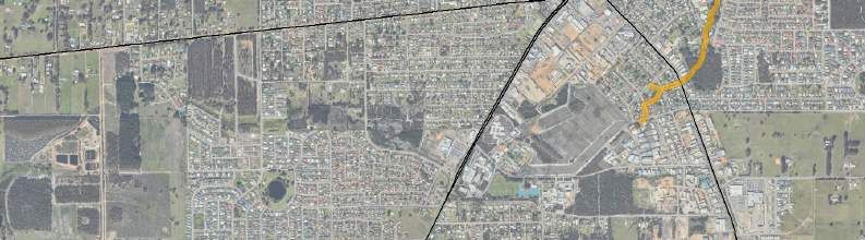
Abbreviations
    ARR        Albany Ring Road
    ASS        Acid Sulfate Soils
    BC Act     Biodiversity Conservation Act 2016

    BoM        Bureau of Meteorology
    CAWS Act   Country Areas Water Supply Act 1947
    CCI        Critical containment infrastructure
    DBCA       Department of Biodiversity, Conservation and Attractions
    DPLH       Department of Planning, Lands and Heritage
    DWER       Department of Water and Environmental Regulation
    EP Act     Environmental Protection Act 1986
    EPBC Act   Environment Protection and Biodiversity Conservation Act 1999
    IA         International Agreement

    OS         Other specially protected fauna
    PEC        Priority Ecological Community
    PDWSA      Public Drinking Water Source Area

    RIWI Act   Rights in Water and Irrigation Act 1914
    SMP        Site Management Plan
    TEC        Threatened Ecological Community
    WTP        Water treatment plant

                                GHD | Report for Main Roads WA - Albany Ring Road Construction Impacts
                                               CSBP Albany Depot Redevelopment Options, 12529600 | 1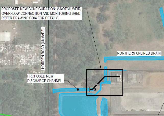
Executive summary
  Construction of the proposed Albany Ring Road (ARR) Stage 2, between chainage 15900 and 17300,
  will impact on infrastructure within the CSBP Limited Albany Fertiliser Distribution Facility (the
  Premises), located at 198 Hanrahan Road, Mount Elphinstone (comprising a portion of Lot 201 on
  Plan 76615), within the City of Albany.
  The CSBP depot operates under a Prescribed Premise licence, L8669/2012/1, under the
  Environmental Protection Act (1986) as administered by the Department of Water and Environmental
  Regulation (DWER) - Part V Licence L8669/2012/1 (the Licence).
  The impacts to the Premises resulting from the ARR encroachment will occur along the southern
  boundary and in particular the south-western corner, significantly impacting CSBP’s ability to continue
  operations and remain compliant with the current Licence with regards to onsite stormwater
  management and offsite discharge.

  This document has been prepared by GHD Pty Ltd (GHD) on behalf of Main Roads WA, to support a
  Works Approval Application for the relocation and rectification of CSBP infrastructure which will be
  impacted as a result of the construction of the proposed ARR.
  The purpose of this document is to provide information on the proposed works associated with
  construction and commissioning of relocated infrastructure, the potential impacts to sensitive receptors
  that may result from emissions or discharges associated with the project and detail how these impacts
  will be mitigated, minimised or adequately controlled. The primary intent of the relocation and
  rectification works proposed is to ensure that the Site continues to operate the same way (i.e. like for
  like) and in accordance with the current Licence water management and discharge parameters.
  This supporting document, together within the DWER Application Form, constitutes the Works
  Approval Application and includes technical information relevant to the proposed works.
  This Works Approval Application does not provide information on the specific ARR disturbance and
  construction impacts within the current Premises boundary and within the road design footprint as
  these approvals are being sought through a separate process by Main Roads WA.

  This report is subject to, and must be read in conjunction with, the limitations set out on the following
  page and the assumptions and qualifications contained throughout the Report.

                                             GHD | Report for Main Roads WA - Albany Ring Road Construction Impacts
                                                            CSBP Albany Depot Redevelopment Options, 12529600 | 2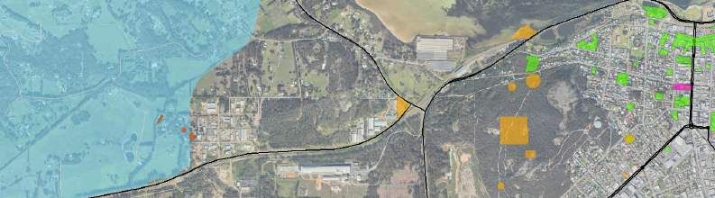
Table of contents
  1.   Introduction .................................................................................................................................... 1
       1.1      Purpose of this report........................................................................................................... 1
       1.2      Works Approval application ................................................................................................. 1
       1.3      Application type.................................................................................................................... 2
       1.4      Works Application Fee ......................................................................................................... 3
  2.   Applicant details ............................................................................................................................. 4
       2.1      Applicant authorisation details .............................................................................................4
       2.2      Occupier status .................................................................................................................... 4
  3.   Premises details ............................................................................................................................. 5
  4.   Siting and location .......................................................................................................................... 7
       4.1      Climate ................................................................................................................................. 7
       4.2      Geology and soils ................................................................................................................ 7
       4.3      Hydrology and hydrogeology ............................................................................................... 9
       4.4      Contamination status .........................................................................................................10
       4.5      Environmentally Sensitive Areas ....................................................................................... 10
       4.6      Threatened and/ or priority ecological communities .......................................................... 10
       4.7      Threatened and/ or priority fauna ...................................................................................... 11
       4.8      Threatened and/ or priority flora ........................................................................................ 12
       4.9      Aboriginal and other heritage sites .................................................................................... 12
       4.10 Summary of nearby sensitive receptors and aspects ........................................................ 12
  5.   Project description........................................................................................................................ 15
       5.1      Prescribed premises infrastructure and equipment ........................................................... 15
       5.2      Extent of ARR encroachment ............................................................................................ 17
       5.3      Impacts to infrastructure along the southern boundary ..................................................... 19
  6.   Detailed description of proposed activities................................................................................... 20
       6.1      Water storage volume compensation ................................................................................ 20
       6.2      Relocation of discharge channel........................................................................................ 22
       6.3      Groundwater monitoring well replacement program.......................................................... 24
       6.4      Clearing activities ............................................................................................................... 24
       6.5      Proposed boundary realignment........................................................................................ 25
       6.6      Summary of proposed activities......................................................................................... 27
       6.7      Environmental commissioning ........................................................................................... 28
  7.   Emissions, discharges and waste ................................................................................................ 29
       7.1      Air emissions...................................................................................................................... 29
       7.2      Noise emissions ................................................................................................................. 29
       7.3      Waste and leachate emissions .......................................................................................... 30
       7.4      Wastewater discharges ..................................................................................................... 31
  8.   Other DWER approvals................................................................................................................ 32

                                                            GHD | Report for Main Roads WA - Albany Ring Road Construction Impacts
                                                                                 CSBP Albany Depot Redevelopment Options, 12529600 | 3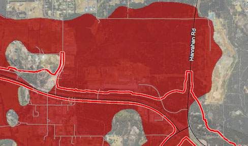
8.1      Pre-application scoping .....................................................................................................32
      8.2      Environmental impact assessment (Part IV of the EP Act) ............................................... 32
      8.3      Clearing of native vegetation (Part V Division 2 of the EP Act and Country Area
               Water Supply Act 1947) ..................................................................................................... 32
      8.4      Country Area Water Supply Act 1947 licence application ................................................. 32
      8.5      Water licences and permits (Rights in Water and Irrigation Act 1914) .............................. 32
9.    Other approvals and consultation ................................................................................................ 33
10.   Submission of any other relevant information .............................................................................. 34
      10.1 Detailed works program schedule ..................................................................................... 34
11.   Limitations .................................................................................................................................... 35
12.   References ................................................................................................................................... 36

                                                           GHD | Report for Main Roads WA - Albany Ring Road Construction Impacts
                                                                                CSBP Albany Depot Redevelopment Options, 12529600 | 4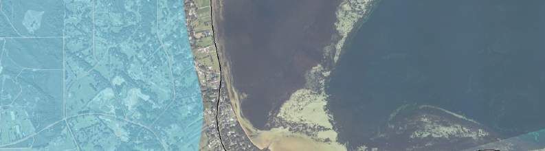
Table index
  Table 1    Reference to DWER application form requirements............................................................ 1
  Table 2    Summary of applicant details............................................................................................... 4
  Table 3    Summary of premises details .............................................................................................. 5
  Table 4    Soil descriptions occurring within the Premises (GoWA, 2020a) ........................................ 8
  Table 5    Nearby environmentally sensitive receptors and aspects ................................................. 12
  Table 6    Summary of existing vs proposed unlined pond design parameters ................................. 21
  Table 7    CSBP’s proposed replacement program of monitoring wells ............................................ 24
  Table 8    Proposed activities and timeframes ................................................................................... 27
  Table 9    Licence monitoring requirements at SW4 (V-notch weir) .................................................. 31
  Table 10   Other approvals and consultation ...................................................................................... 33

Plate index
  Plate 1    Albany Site Number 9500 Climate Data (1877-2020) (BoM 2020) ..................................... 7
  Plate 2    Excerpt of ASS risk mapping overlain by the ARR footprint and CSBP site ....................... 8

  Plate 3    Survey model output of ARR construction footprint in relation to CSBP’s water
             storage infrastructure ......................................................................................................... 17
  Plate 4    Design showing ARR extent/ finishes near lined pond and minimum clearance
             at top of bank ..................................................................................................................... 18
  Plate 5    3-D Model output showing toe drain, fence and lined pond .............................................. 19
  Plate 6    Cross sectional representation of the ARR construction encroachment into the
             unlined pond ...................................................................................................................... 19
  Plate 7    3-D model output of the unlined pond following expansion to the east (looking
             north) .................................................................................................................................. 21

  Plate 8    Proposed diversion of the unlined drain on the southern boundary (looking
             north) .................................................................................................................................. 22
  Plate 9    Proposed diversion of the unlined drain on the southern boundary (looking
             south-east) ......................................................................................................................... 22
  Plate 10   Proposed new location and connections for the discharge channel ................................. 23

Figure index
  Figure 1   Premises Location and Boundary ........................................................................................ 6
  Figure 2   Premises Siting and Location ............................................................................................ 14
  Figure 3   Premises current licensed infrastructure and equipment .................................................. 16
  Figure 4   Proposed groundwater bore reinstallation program .......................................................... 26

                                                         GHD | Report for Main Roads WA - Albany Ring Road Construction Impacts
                                                                              CSBP Albany Depot Redevelopment Options, 12529600 | 5
Appendices
  Appendix A – Summary of cost estimate
  Appendix B – Proof of occupier status
  Appendix C – Proposed activities

  Appendix D – Indicative works schedule

                                           GHD | Report for Main Roads WA - Albany Ring Road Construction Impacts
                                                          CSBP Albany Depot Redevelopment Options, 12529600 | 6
1.   Introduction
     1.1       Purpose of this report
     Main Roads is proposing to construct and operate the Albany Ring Road (ARR). Construction of
     the proposed ARR will impact on infrastructure within the CSBP Limited Albany Fertiliser
     Distribution Facility (the Premises), located at 198 Hanrahan Road, Mount Elphinstone within
     the City of Albany.
     The impacts by the proposed ARR construction includes operating infrastructure inside the
     Premises boundary licenced under the Environmental Protection Act 1986, Part V Licence
     L8669/2012/1.
     The purpose of this document is to provide information on the proposed works associated with
     construction and commissioning of relocated infrastructure, the potential impacts to sensitive
     receptors that may result from emissions or discharges associated with the project and detail
     how these impacts will be mitigated, minimised or adequately controlled.
     This document has been prepared by GHD Pty Ltd (GHD) on behalf of Main Roads WA to
     support a Works Approval Application for relocation of CSBP infrastructure which will impacted
     as a result of the construction of the proposed ARR. This Works Approval Application does not
     provide information on the specific ARR disturbance and construction impacts within the current
     Premises boundary as these approvals are being sought through a separate process by Main
     Roads WA.
     This supporting document, together within the DWER Application Form, constitutes the Works
     Approval Application and includes technical information relevant to the proposed works.

     1.2       Works Approval application
     Information requested in the DWER Application Form is provided throughout this supporting
     report. Table 1 refers to where each requirement can be found in this document.
     Table 1      Reference to DWER application form requirements

      Application form requirements                                           Supporting report location
      Part 1: Application type                                                Section 1.3
      Part 2: Applicant details                                               Section 2
      Part 3: Premises details                                                Section 3
      Part 5: Index of Biodiversity Surveys for Assessment and Index          Not required
      of Marine Surveys for Assessment
      Part 6: Other DWER approvals                                            Section 8
      Part 7: Other approvals and consultation                                Section 9
      Part 8: Applicant history                                               Not required
      Part 9: Emissions, discharges, and waste                                Section 7
      Part 10: Siting and location                                            Section 4
      Part 11: Submission of any other relevant information                   Section 10
      Part 12: Proposed fee calculation                                       Section 1.4, Appendix A
      Part 13: Commercially sensitive or confidential information             Application form

                                          GHD | Report for Main Roads WA - Albany Ring Road Construction Impacts
                                                         CSBP Albany Depot Redevelopment Options, 12529600 | 1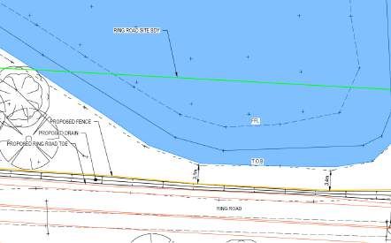
Application form requirements                                           Supporting report location
 Part 14: Submission of application                                      Application form
 Part 15: Declaration and signature                                      Application form
 Attachment 1A: Proof of occupier status                                 Appendix B
 Attachment 1B: ASIC company extract                                     Appendix B
 Attachment 1C: Authorisation to act as a representative of the          Not required
 occupier
 Attachment 2: Premises map/s                                            Figure 1, page 6
 Attachment 3A: Environmental commissioning plan                         See Section 6.7
 Attachment 3B: Proposed activities                                      Appendix C
 Attachment 3C: Map of area proposed to be cleared (only                 Drawing C011, Appendix D
 applicable if clearing is proposed)                                     Note no native vegetation
                                                                         clearing is proposed.
 Attachment 3D: Additional information for clearing assessment           Not required
 Attachment 4: Marine surveys (only applicable if marine                 Not required
 surveys included in application)
 Attachment 5: Other approvals and consultation documentation            Not required
 Attachment 6A: Emissions and discharges                                 See Section 7
 Attachment 6B: Waste acceptance                                         Not required
 Attachment 7: Siting and location                                       Figure 2, page 14
 Attachment 8: Additional information submitted                          See Section 10
 Attachment 9: Proposed fee calculation                                  Appendix A
 Attachment 10: Request for exemption from publication                   Not required

1.3      Application type

1.3.1    Current application type

The current application is for a Works Approval under Part V, Division 3 of the Environmental
Protection Act 1986 (EP Act).

1.3.2    Prescribed Premise licence (L8669/2012/1) overview

The CSBP depot operates under a Prescribed Premise licence, L8669/2012/1, under the
Environmental Protection Act (1986) as administered by the Department of Water and
Environmental Regulation (DWER).

This licence expires 12 December 2021, therefore there are more than 90 days until the expiry
of the existing licence.

1.3.3    Premises categories

The site is a Category 33 licensed premise for “chemical blending or mixing: premises on which
chemicals or chemical products are mixed, blended, or packaged in a manner that causes or is
likely to cause a discharge of waste to the environment (up to 500 tpa)”.

                                     GHD | Report for Main Roads WA - Albany Ring Road Construction Impacts
                                                    CSBP Albany Depot Redevelopment Options, 12529600 | 2
The site licence requires that the stormwater from the site is managed by directing it away from
the areas where fertilisers and product materials are stored onsite (using lined perimeter
drains). It also requires that any stormwater and/or wastewater that is potentially contaminated
should be collected within the lined drains and go through the lined pond to the water treatment
plant onsite (stormwater overflows from high rainfall periods being an exception).
The licence also states that all wastewater from within the site should only be discharged
through the v-notch weir to the Munster Hill Drain with stipulated monitoring requirements and
licence limits for stormwater.

1.4      Works Application Fee
Using the Works Approval fee calculator available via the DWER website, the fee for this Works
Approval Application (WAA) is understood to be $3,857. This fee was calculated from the cost
of the works in accordance with Regulation 5BA and Schedule 3 of the Environmental
Protection Regulations 1987, including all costs associated with the construction and
establishment of the prescribed premises infrastructure. The estimated cost of the Project on
which the fee calculation is based is up to $387,000 (incl. GST).
A summary of the cost estimate is included in Appendix A.

                                   GHD | Report for Main Roads WA - Albany Ring Road Construction Impacts
                                                  CSBP Albany Depot Redevelopment Options, 12529600 | 3
2. Applicant details
2.1 Applicant authorisation details
The applicant details are summarised in Table 2 below.
Table 2 Summary of applicant details
Applicant name CSBP Limited
ACN 008 668 371
Authorised representative and Name Stephanie Felstead
contact person Position Environmental Superintendent
Organisation CSBP Limited
PO Box 345
Address
KWINANA WA 6966
Telephone 0448 794956
Email stephanie.felstead@csbp.com.au
Registered office address, as
registered with the Australian 'Brookfield Place Tower 2' Level 14, 123 St Georges
Securities and Investments Terrace, PERTH WA 6000
Commission (ASIC)
Postal address PO Box 345
KWINANA WA 6966
Contact person and technical Name Alison White
enquiries Position Senior Environmental Advisor
Organisation CSBP Limited
PO Box 345
Address
KWINANA WA 6966
Telephone 0419 904 608
Email alison.white@csbp.com.au
2.2 Occupier status
CSBP Limited is the registered proprietor on the certificate of title.
Proof of occupier status is provide as per copies of the certificate of title for 198 Hanrahan Road
and ASIC company extract are provided in Appendix B.
GHD | Report for Main Roads WA - Albany Ring Road Construction Impacts
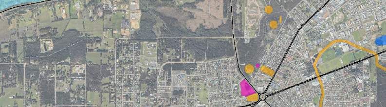
CSBP Albany Depot Redevelopment Options, 12529600 | 43. Premises details
The Premises occupy a portion of Lot 201 on Plan 76615. Lot 201 on Plan 76615 is comprised
of three portions, one on the northern side of Lower Denmark Road and two smaller portions on
the southern side of Lower Denmark Road (Figure 1). The portion of Lot 201 on the northern
side of Lower Denmark Road comprises the current Premises boundary and is therefore the
defined Premises for the purposes of the Work Approval Application.
The Premises details are summarised in Table 3 below and the location is presented in
Figure 1.
Table 3 Summary of premises details
Aspect Details
Premises description A Portion of Lot 201 on Plan 76615 – formerly Lot 2 on Plan
230541 prior to a cadastral boundary change when a portion
of Lot 2, on the eastern side of Hanrahan Road, was sold to
the City of Albany
Premises street address 198 Hanrahan Road, Mount Elphinstone
ALBANY WA 6330
Premises name CSBP Limited Albany Fertiliser Distribution Facility
Premise boundary A portion of Lot 201 bounded to the west by Hanrahan Rd,
description the east by the Munster Hill Drain and the south by the
railway reserve adjacent to Lower Denmark Rd
Local Government Authority City of Albany
area
GPS (latitude and longitude) The current Premises boundary GPS location (corners)
coordinates includes:
(GDA 1994 MGA Zone 50) 577,228 E, 6,125,391 N
578,355 E, 6,125,380 N
578,355 E, 6,125,284 N
578,535 E, 6,125,281 N
578,479 E, 6,124,287 N
578,406 E, 6,124,212 N
577,223 E, 6,124,539 N
GHD | Report for Main Roads WA - Albany Ring Road Construction Impacts
CSBP Albany Depot Redevelopment Options, 12529600 | 5Legend
Main Roads
Minor Roads
Track
Current License
Premise Boundary
Lot 201 on Plan
76615
N anarup R d
ba
ny
Al
Hw Menang Dr
y
d
ss R
Pa
ster
Ch e
Rd
Low er King
South C oast H w
y Mermaid Av
t Dr
Tro
d oin
dR
ode
o
wo
uP
ALBANY !
(
S
g
Em
A ngo llin
t
Nort ve R o
h Rd d C
H anrahan R d
R d
Rd
ks
Lower Denmark Rd
L in
C ampbell
Mid
lf
Go
d le
ton
Rd
Pr
inc
e
York St
ss R
oy a l
Dr
LITTLE GROVE
(
!
Rd
Ba y
man
nch
F re
(
!
(
!
DARKAN WAGIN DUMBLEYUNG
(
! (
! (
!
KATANNING
(
!
KOJONUP
(
! JERRAMUNGUP
TAMBELLUP
(
! (
!
(
!
CRANBROOK
(
! BREMER BAY
(
!
MOUNT BARKER
(
!
WALPOLE DENMARK
ALBANY
(
! (
! ! LITTLE GROVE
(
(
!
Paper Size ISO A3 Main Roads WA Project No. 12529600
o
0 1 2 3 Albany Ring Road Construction Impacts Revision No. 0
CSBP Albany Depot Redevelopment Options Date 13/10/2020
Kilometres
Map Projection: Transverse Mercator
Horizontal Datum: GDA 1994 Premises Map - CSBP Limited Albany
Grid: GDA 1994 MGA Zone 50
Fertiliser Distribution Facility FIGURE 1
Data source: GHD: Premises Boundary - 20200930; LGATE: Roads - 201910, Imagery accessed on 20201013. Created by: slei4. Siting and location
4.1 Climate
Albany experiences a Mediterranean climate with cool, wet winters and warm, dry summers.
Rainfall is generally received in winter (June - August). The area also receives periodic summer
rainfall as a result of thunderstorm activity or rain-bearing depressions from tropical cyclones.
The closest Bureau of Meteorology (BoM) weather station with sufficient historical data is
Albany (site number 009500), located approximately 1.7 km east of the Project Area, at its
closest point (BoM, 2020). Climate data from this station indicates the mean maximum
temperature ranges from 22.9°C in February to 15.8°C in July. The mean minimum temperature
ranges from 15.6°C in February to 8.2°C in July. The mean annual rainfall is 925.1 mm, with
approximately 103 rain days a year (BoM, 2020).
25 160
140
20
120
Temperature (oC)
Rainfall (mm)
15 100
80
10 60
40
5
20
0 0
Jan Feb Mar Apr May Jun Jul Aug Sep Oct Nov Dec
Month
Mean monthly rainfall Mean maximum temperature
Mean minimum temperature
Plate 1 Albany Site Number 9500 Climate Data (1877-2020) (BoM 2020)
4.2 Geology and soils
4.2.1 Regional geology
Regional geological mapping (1:250,000) indicates the Premises area is underlain by Qc –
Colluvium (sand, silt and clay) (Allen & Sofoulis, 1984).
4.2.2 Soils
Three soils types have been mapped, by Department of Primary Industries and Regional
Development (DPIRD), within the Premises area, however the Owingup Subsystem is the
dominant soil type across the site (GoWA, 2020a). The soil unit ID, name, description and
known salinity and water erosion risks for these soil types are presented in Table 4.
GHD | Report for Main Roads WA - Albany Ring Road Construction Impacts
CSBP Albany Depot Redevelopment Options, 12529600 | 7Table 4 Soil descriptions occurring within the Premises (GoWA, 2020a)
Soil unit ID Name Description Salinity risk Water erosion risk
242TbOW Owingup Plains with 3 to 10 % of map 3 to 10 % of map
Subsystem swamps, lunettes unit has a unit has a high to
and dunes. Yellow moderate to high extreme water
solonetzic soils, salinity risk or is erosion risk.
organic loams and presently saline.
diatomaceous
earth; Podzols on
dunes.
242MmGAs Gardner Leached sands andbe acidified once oxidised) and will require treatment/management through liming when
excavated.
Further to this, it was inferred that the sand units in the unsaturated zone above the
groundwater table appeared to have already oxidised and represent an Actual ASS risk
(existing acidity). The unsaturated soil units will also require appropriate management if
disturbed however they are not expected to oxidise further and/or reactions are expected to be
at a much slower rate than the units below the water table.
4.3 Hydrology and hydrogeology
4.3.1 Groundwater
The Premises lie directly to the north of the Albany Groundwater Protection Area (GPA)
protected under the Rights in Water and Irrigation Act 1914 (RIWI Act). Lower Denmark Road
forms the northern boundary of this GPA (GoWA, 2020a).
The Premises are not intercepted by any Public Drinking Water Source Areas (PDWSA),
however the South Coast Water Reserve lies approximately 800 m to the south west. This
PDWSA is managed under the Country Areas Water Supply Act 1947 (CAWS Act) (GoWA,
2020a).
Historical data for June to August (winter months), for the groundwater wells that lie on the
southern boundary, the depth to water measured from below the top of casing (m bTOC) ranged
from 1.05 m in C12 (8.235 mAHD) to 2.92 m in C17 (10.395 mAHD). Generally though across
the site, groundwater is within 2-3 m of the ground surface depending on the time of the year.
4.3.2 Surface water
The area is located within the Princess Royal Harbour Catchment of the Albany Coast Basin in
the South West Division.
Lower Denmark Road is intercepted by a number of artificial channels, including the Munster
Hill Drain which lies on the western boundary of the Premises. This channel flows north to south
across Lower Denmark Road, connecting to Robinson Drain, and ultimately drains to Princess
Royal Harbour (GoWA, 2020a).
The Premises are not intercepted by any RIWI Act Rivers.
4.3.3 Wetlands
The Premises do not intercept any wetlands categorised as the following (GHD, 2020; GoWA,
2020a):
The Department of Biodiversity, Conservation and Attractions (DBCA’)s Directory of
Important Wetlands in Australia (DBCA-045)
Redbook Recommended Conservation Reserves 1976-1991 (DBCA-029)
South Coast Significant Wetlands (DBCA-018)
Ramsar Sites (DBCA-010) and Water Information Reporting (DWER, 2019)
The closest Nationally Important Wetland is Oyster Harbour, which lies approximately 9.5 km to
the east of the Premises (GoWA, 2020a).
The Gledhow Conservation Category Wetlands, as mapped in the DBCA South Coast
Significant Wetlands dataset, are located approximately 650 m southwest of the Premises
boundary. In addition Conservation Category wetlands Seven Mile Creek, within the King River
Suite, are located approximately 7.7 km to the north west (GoWA, 2020a).
GHD | Report for Main Roads WA - Albany Ring Road Construction Impacts
CSBP Albany Depot Redevelopment Options, 12529600 | 94.4 Contamination status
CSBP has submitted documentation to DWER in support of reclassifying several portions of Lot
201, with an intent to achieved Remediated for restricted use under the Contaminated Sites Act
2003 for the Premises. Under such classification, the restrictions on use are likely to comprise
restrictions on groundwater abstraction and sub-surface excavation in certain areas (governed
by a Site Management Plan (SMP)).
An overview of the contamination concerns at the site (described by media) is provided below:
Soils: primarily within the former Sulfur Pad Area, where there are buried wastes consisting
of materials from historical site activities including manufacturing and production of
chemicals (superphosphate and sulfuric acid). These areas are away from the proposed
ARR alignment and the proposed areas requiring infrastructure realignment and are
unlikely to be intercepted.
Groundwater: elevated concentrations of nutrients and metals in groundwater are present
within the CSBP depot site working area, resulting from historical activities of storages,
spillages, disposal of product materials and wastes as well as manufacture and production
of chemicals and fertilisers. GHD notes that the Hanrahan Road landfill site is located up-
hydraulic gradient of the site and may also contribute to the water quality observed through
landfill leachate migration in groundwater.
Surface water: the surface water quality is expected to be largely free of contaminates
other than residual products on the surface of the catchment area from product dust
accumulation on roof and hard stand areas and operational spills (product or mechanical
liquids from machinery/ vehicles onsite).
Sediments: Aurora Environmental (2019a) undertook sampling and analysis of the
sediments within the unlined pond (analysed for metals, trace elements, pH, nutrients,
sulfate, and asbestos) and did not report anything above the assessment criteria.
Desludged materials from the lined (treatment) pond are placed on hardstand areas or the
drying beds adjacent to the water treatment plant (WTP) in accordance with the Licence.
4.5 Environmentally Sensitive Areas
No Environmentally Sensitive Areas (ESAs) have been identified within the Premises area,
during desktop and site investigations (GoWA, 2020a). The closest ESA is located
approximately 3.9 km to the east of the Premises on Mount Clarence, Albany (Figure 2).
4.6 Threatened and/ or priority ecological communities
During the Biological Survey of the ARR, Southern Ecology (2020) mapped the vegetation
within the area impacted by this Works Approval application as “Mature Planted Trees (Iron
Barks, Blue Gum, Tuart, other Eucalypts and Peppermint generally > 10 years old)”.
Southern Ecology (2020) did not identify any Threatened Ecological Communities (TECs) listed
under the Commonwealth EPBC Act or State Biodiversity Conservation Act 2016 (BC Act), or
Priority Ecological Communities (PECs) listed by DBCA within the Works Approval application
area.
Two TECs and four PECs were found to occur in the local area and include the following
(Southern Ecology, 2020):
Subtropical and Temperate Coastal Saltmarsh TEC (Vulnerable) – occurs on the margin of
Princess Royal Harbour and is confined to marine saline habitats therefore is not applicable
to vegetation with in the Premises.
GHD | Report for Main Roads WA - Albany Ring Road Construction Impacts
CSBP Albany Depot Redevelopment Options, 12529600 | 10 Proteaceae Dominated Kwongan Shrubland TEC (Endangered) – the Premises boundary
is located outside the South East Coastal Botanical Provence, therefore this TEC is not
present.
Banksia coccinea Thicket (Priority 1), Coastal Melaleuca incana/ Taxandria juniperina
(Priority 1) and Banksia littoralis/Melaleuca incana (Priority 1) have distinctive dominant
species which are absent from the surveyed area.
Astartea scoparia Swamp Thicket (Priority 1) may have previously occurred in the wetlands
along Lower Denmark Road however this PEC was not identified during the Biological
Survey as this area is now dominated by weeds, has a high level of disturbance and altered
drainage.
4.7 Threatened and/ or priority fauna
Field assessments for the ARR Biological Survey confirmed that habitat within the Premises
may potentially be utilised by conservation significant fauna including (Southern Ecology, 2020):
Baudin's Cockatoo (Calyptorhynchus baudinii) (Threatened-Endangered)
Carnaby’s Cockatoo (Calyptorhynchus latirostris) (Threatened-Endangered)
Forest Red-tailed Black Cockatoo (Calyptorhynchus banksii subsp. naso) (Threatened-
Vulnerable)
Western Ringtail Possum (WRP) (Pseudocheirus occidentalis) (Threatened-Critically
Endangered)
Quenda (Isoodon obesulus subsp. fusciventer) (Priority 4)
In addition to the above species, seven significant fauna species listed under state legislation
were considered to possibly occur within the ARR survey area despite not being recorded
during Southern Ecology (2020) field investigations, and therefore may also occur within the
Premises:
South-western Brush-tailed Phascogale (Phascogale tapoatafa wambenger) (Conservation
Dependent (CD))
Masked Owl (Tyto novaehollandiae subsp. novaehollandiae) (Priority 3)
Short-nosed Snake (Elapognathus minor) (Priority 2)
Fork-tailed Swift (Apus pacificus) (International Agreement (IA))
Woollybush bee (Hylaeus globuliferus) (Priority 3)
Water-rat, Rakali (Hydromys chrysogaster) (Priority 4)
Peregrine Falcon (Falco peregrinus) (Other specially protected fauna (OS)).
Of these, only Black Cockatoo are considered likely to utilise the non-native Mature Planted
Trees vegetation type that are proposed to be cleared for the project.
4.7.1 Black Cockatoos
Southern Ecology (2020) mapped the Mature Planted Trees vegetation type as high quality
potential roosting habitat for Black Cockatoo species. Survey of this vegetation by Biota (2019)
identified five potential Black Cockatoo trees, with a diameter at breast height (DBH) greater
than 500 mm, along the boundary of Lot 201 with Lower Denmark Road. However it is
considered that these trees will be avoided for clearing for relocation of CSBP infrastructure. No
roosting evidence was recorded during the survey (Biota, 2019).
GHD | Report for Main Roads WA - Albany Ring Road Construction Impacts
CSBP Albany Depot Redevelopment Options, 12529600 | 114.8 Threatened and/ or priority flora
There were no threatened or priority flora identified within the Works Approval application area
during the Biological Survey undertaken for the ARR (Southern Ecology, 2020).
4.9 Aboriginal and other heritage sites
A desktop search of the Department of Planning, Lands and Heritage (DPLH) Aboriginal
Heritage Inquiry System did not identify any Registered Sites or Other Heritage Places within
the Premises. The closest Registered Site (Site ID 22527) is approximately 600 m to the
northeast of the Premises boundary. The nearest Other Heritage Place (Place ID 23288) is
approximately 50 m to the south of the Premises boundary (DPLH, 2020).
A desktop search of heritage places on the Heritage Council inHerit database indicated that
there are no cultural places listed in the State Register of Heritage Places, local government
inventories and other lists, the Australian Government’s heritage list and other non-government
lists and surveys within the Premises boundary. The nearest heritage place is the Albany
Seaboard Bulk Fuel Oil Depot Site (Place Number 26441) located at Lots 76 and 877 Hanrahan
Road, directly adjacent to the east of the Premises boundary (GoWA, 2020b).
4.10 Summary of nearby sensitive receptors and aspects
Distance to nearby sensitive receptors from the Premises boundary and proposed impact
mitigation measures have been summarised in Table 5 and illustrated in Figure 2.
Table 5 Nearby environmentally sensitive receptors and aspects
Type/ Description Distance + Proposed controls to
Classification direction to prevent or mitigate
premises adverse impacts (if
boundary applicable)
ESAs No ESAs have been 3.9 km to the east NA
identified within the
Premises boundary
Threatened No TECs or PECs - As per current licence
Ecological identified within the Works conditions
Communities Approval application area
Subtropical and 1.4 km to south
Temperate Coastal east from
Saltmarsh TEC wastewater
discharge point
Threatened Black Cockatoos, WRP Within Premises A preclearance fauna
and/or priority and Quenda boundary inspection prior to
fauna clearing vegetation for
the purpose of this
Works Approval
application
Threatened No threatened or priority - As per current licence
and/or priority flora identified within the conditions
flora Works Approval
application area
Aboriginal and Aboriginal Heritage 600 m north east NA
other heritage Registered Site ID 2257
sites
Other Heritage Place ID 50 m south NA
23288
GHD | Report for Main Roads WA - Albany Ring Road Construction Impacts
CSBP Albany Depot Redevelopment Options, 12529600 | 12Type/ Description Distance + Proposed controls to
Classification direction to prevent or mitigate
premises adverse impacts (if
boundary applicable)
Heritage Council Place Adjacent to the NA
Number 26441 east
Public drinking South Coast Water 800 m south west As per current licence
water source Reserve conditions
areas
Rivers, lakes, Munster Hill Drain Adjacent to the As per current licence
oceans, and west conditions
other bodies of
surface water, Gledhow Conservation 650 m southwest As per current licence
etc. Category Wetlands conditions
Nationally Important 9.5 km to the east NA
Wetland – Oyster Harbour
Acid sulfate The Premises are Within Premises Excavated spoil is
soils mapped within an area of boundary proposed to be
high to moderate risk of assessed for ASS and
actual ASS and potential treated with lime (if
ASS occurring within 3 m required) suitable for
of the natural soil profile reuse onsite. No
dewatering will be
undertaken. Refer to
Section 7.3.1 for
proposed ASS
management approach
GHD | Report for Main Roads WA - Albany Ring Road Construction Impacts
CSBP Albany Depot Redevelopment Options, 12529600 | 13Legend
Natural Drainage Line
Main Roads
Minor Roads
Track
Current License Premise Boundary
s Rd
Public Drinking Water Source Areas
Pas
South Coast Significant Wetlands -
s ter
Conservation Class
Ch e
Aboriginal Heritage Registered Sites
Contact DAA South C oast
H wy
Registered Site
Other Registered Site (Lodged, Stored
Data/Not a Site) C h
es
European Registered Heritage Places
te r P
as s R
ty
State Registered Place
Nort
h Rd
Municipal Inventory Place
Albany Seaboard Bulk Fuel Oil Depot
Site
Al
ba
n
Hanrahan Rd
yH
wy
Low
e r De
nma
rk R
d
St Em
Albany Seaboard Bulk
ie Way
il
Frenchman Bay Fuel Oil Depot Site
York St
Road Camp
Princ
ess
R oy a
l Dr
Frenchman Ba
y Rd
Paper Size ISO A3 Main Roads WA Project No. 12529600
o
0 100 200 300 400 500 Albany Ring Road Construction Impacts Revision No. 1
CSBP Albany Depot Redevelopment Options Date 21/10/2020
Metres
Map Projection: Transverse Mercator
Horizontal Datum: GDA 1994 Premises Siting and Location
Grid: GDA 1994 MGA Zone 50
FIGURE 2
Data source: GHD: Premises Boundary - 20200930; SHO: Aboriginal heritage registered sites, state registered sites - 20190820; LGATE: Roads - 201910, Imagery accessed on 20201021. Created by: slei5. Project description
The proposed alignment of the ARR construction project (Stage 2), between chainage 15900
and 17300 encroaches into the current CSBP depot at Lot 201 (198), Hanrahan Road. The
impacts to the CSBP depot will occur along the southern boundary and in particular the south-
western corner, significantly impacting CSBP’s ability to continue operations and remain
compliant with the current licence with regards to onsite stormwater management and offsite
discharge. The presence of the rail line to the south of the CSBP depot, and the necessary set
back distances from that, dictate the location of the southern extent of the ARR project and
construction boundary. Impacts to the CSBP property are unavoidable.
An overview of the current Premises infrastructure and the impact on this infrastructure through
the construction of the ARR is provided in the following sections. The proposed relocation and
rectification works to account for the loss of infrastructure along the southern boundary of the
Premises are presented within Section 6. Through the proposed activities, GHD has redesigned
the stormwater management system to replicate the previous arrangement and to maintain the
same performance as required under the conditions of the Premises Licence.
5.1 Prescribed premises infrastructure and equipment
Items of infrastructure and equipment identified within the boundary of the Prescribed Premises
relevant to this application include:
Lined Pond (SW11)
Unlined Pond (SW08)
Unlined Drains (southern)
V-Notch Weir, connections, discharge channel and monitoring shed (SW04)
The lined pond is used to store stormwater that may contain nutrients and trace elements from
fertiliser and is considered low risk so not considered as critical containment infrastructure
(CCI).
Each item has also been identified and included on Premises map in Figure 3.
5.1.1 Premises boundary change
To facilitate the construction of the ARR, Main Roads WA are required to acquire a portion of
land within the current CSBP Premises along the southern and eastern boundaries. The change
in the final boundary of the Premises will require surveying and submission to DWER as part of
the Licence amendment following the completion of the rectification works outlined within the
WAA.
GHD | Report for Main Roads WA - Albany Ring Road Construction Impacts
CSBP Albany Depot Redevelopment Options, 12529600 | 15Legend
Major Road
Minor Road
Lined Drains
Unlined Drains
Munster Hill Drain
Existing Drainage Channel
Existing treated water pipe
New Muster Drain Culvert
Open Drainage Channel
Cadastre
V - Notch Weir
Lined Drain Discharge
Channel
SW8 & SW11
Northern
unlined drain Shed housing monitoring
equipment
Maintain Munster
Hill Drain WWTP
Existing unlined
drained linked to
Munster Hill drain.
Currently not in use.
Sludge beds
WWTP
Existing treated
water pipe Emergency Access track
SW11
SW8
V-notch weir and
monitoring shed
New Munster
Drain Culvert
Lower Denmark Rd
Hordern St
t
gS
rlin
Sti
Paper Size ISO A3 Main Roads WA Project No. 12529600
o
0 10 20 30 40 50 Albany Ring Road CSBP Depot Revision No. B
Redevelopment Options and Approvals Date 01 Oct 2020
Metres
Map Projection: Transverse Mercator
Horizontal Datum: GDA 1994 Premises current licensed
Grid: GDA 1994 MGA Zone 50
infrastructure and equipment FIGURE 3
Data source: GHD: Boreholes, Groundwater levels, Inferred granite outcrop and subcrop, CBSP Plan - 20200514; Landgate: Roads - 20190128, Imagery - 20190120 accessed 20200514. Created by: slei5.2 Extent of ARR encroachment
To accurately depict the extent of encroachment onto the southern boundary of the CSBP site,
GHD modelled the latest site survey information (JKA, 2020) and latest ARR design (GHD,
2019). The extent of the ARR encroachment onto the Premises is shown on Plate 3.
As shown in Plate 3, the modelled output indicates that there is currently no encroachment of
the ARR into the lined pond (SW11) but there is encroachment into the unlined pond (SW08)
and southern unlined drain system, as well as complete filling over the current V-notch weir and
associated discharge drain.
Refer to Plate 3 for rendered output from the 3-D model with water level in the ponds set at
7.0 m AHD (unlined pond) and 7.35 m AHD (lined pond).
Plate 3 Survey model output of ARR construction footprint in relation to
CSBP’s water storage infrastructure
5.2.1 Road setbacks from the lined pond
Based on the current design (GHD, 2019), the ARR northern footprint extent (as shown in
Plate 3) does not encroach onto the lined pond, however the road finishes adjacent to the top of
the embankment. The following design considerations are to be incorporated as part of the road
construction and approvals through Main Roads WA and not as part of the current WAA
proposed activities. These works are proposed to manage stormwater generated from the ARR
construction batter and allow CSBP vehicle access and a general maintenance area at the
maximum capacity level of the lined pond, including:
The northern, final fill batter of the ARR is required to be at 1V:1.5H
A drain will be installed at the toe of the northern ARR batter at 1:1 (rock pitching required
and not earth). The drain will have a minimum 300 mm depth at the toe of the batter with
0.5% fall from east to west toward the existing drain (towards the Munster Hill Drain)
GHD | Report for Main Roads WA - Albany Ring Road Construction Impacts
CSBP Albany Depot Redevelopment Options, 12529600 | 17 A 2 m high boundary fence has been provisioned for installation on the north side of the toe
drain
A minimum of 3.1 m wide access (between boundary fence and top of bank) will be
available to CSBP at the highest water level in the lined pond (7.98 m AHD)
A 3 m wide unsealed access road on the top of embankment will be constructed with a one-
way cross fall grading into the newly cut 1:1 drain (i.e. away from the lined pond)
The design, with regard to the finished ARR boundary extent adjacent to the lined pond, is
shown in Plate 4 and Plate 5 with the full drawing set presented in Appendix C.
Plate 4 Design showing ARR extent/ finishes near lined pond and minimum
clearance at top of bank
GHD | Report for Main Roads WA - Albany Ring Road Construction Impacts
CSBP Albany Depot Redevelopment Options, 12529600 | 18Plate 5 3-D Model output showing toe drain, fence and lined pond
5.3 Impacts to infrastructure along the southern boundary
The construction of the ARR will have a significant impact to the water management
infrastructure along the CSBP southern boundary including the following key aspects:
Unlined pond (SW08): part- storage capacity lost due to infill (approximately 475 m3 of
storage volume to be lost with water level in the pond at 7.0 m AHD). Further to this the
extreme event overflow connection between the unlined pond and the concrete discharge
channel will be lost.
Concrete V-notch weir and discharge drain: to be completely infilled
Associated monitoring shed/ equipment connections within the V-notch weir: to be
disconnected and relocated
Groundwater monitoring bores to be lost/destroyed, including:
o Listed within the current Licence as part of the monitoring network: C12, C15 and C17
o Other bores onsite that will be lost/destroyed but are not included within the current
Licence as part of the groundwater monitoring network: C1, C16, C18, AW3, AW19
and AW23
Southern unlined drain: to be completely infilled.
The extent of infill into the unlined pond is represented on the cross sectional representation
presented in Plate 6 and presented on the 3-D model output on Plate 3.
Plate 6 Cross sectional representation of the ARR construction
encroachment into the unlined pond
GHD | Report for Main Roads WA - Albany Ring Road Construction Impacts
CSBP Albany Depot Redevelopment Options, 12529600 | 196. Detailed description of proposed
activities
The overall proposed location and layout of the relocated infrastructure and presented in
Drawing 12529600-C002 within Appendix C.
A detailed description of the redesign and relocation of the impacted infrastructure within the
Premises is provided in the following sections.
6.1 Water storage volume compensation
6.1.1 Lined pond system (SW11)
The lined pond (SW11) is located at the south western corner of the Premises. The pond
captures all of the stormwater runoff from the hardstand area (and from the lined drain network)
and stores it ready to be processed through the water treatment plant (WTP). Please refer to
Figure 3 for the location of these key infrastructure.
As presented in Section 4.2, the ARR design does not impact on the storage capacity of the
lined pond.
6.1.2 Unlined pond (SW08) and unlined drain systems
The current unlined pond volume from the survey with an overflow water level at 7.00 m AHD is
1,758 m3. With the encroachment of the ARR into the site, the unlined storage pond has a
remaining storage capacity of approximately 1,283 m3, resulting in a loss of capacity of
approximately 475 m3.
Due to the loss of capacity on the southern boundary through the construction of the ARR, the
eastern end of the current unlined pond will be excavated to increase the overall capacity and
maintain the same base area /footprint as the current pond. This ensures the modified pond
intersects the same surface area of the groundwater table.
As presented in Plate 7, and illustrated in orange, to expand the unlined pond further east to the
extent of the current emergency access track, 2,111 m3 of soil is required to be cut. Once
excavated to this extent, and with a revised overflow water height of 7.4 m AHD, the storage
capacity of the unlined pond would be increased to 3,313 m3. This action will provide additional
capacity for CSBP in the unlined pond system and will reduce the frequency of overflow events
resulting in direct discharge to the Munster Hill Drain.
The design drawings for the unlined pond are presented as Appendix C.
GHD | Report for Main Roads WA - Albany Ring Road Construction Impacts
CSBP Albany Depot Redevelopment Options, 12529600 | 20Plate 7 3-D model output of the unlined pond following expansion to the
east (looking north)
A summary of the proposed changes to the unlined pond system are presented in Table 6.
Table 6 Summary of existing vs proposed unlined pond design parameters
Design element Existing unlined Proposed unlined Variance
pond pond
Pond base area 3,152 m2 3,231 m2Plate 8 Proposed diversion of the unlined drain on the southern boundary
(looking north)
Plate 9 Proposed diversion of the unlined drain on the southern boundary
(looking south-east)
6.2 Relocation of discharge channel
The proposed location and layout of the new discharge channel and connections is shown in
Plate 10 with the detailed design drawing presented in Appendix C as 12529600-C004.
6.2.1 Discharge channel and V-notch weir
The discharge channel receives treated water from the treatment plant and monitors the outflow
rate (via a V-notch weir) and sampling. Monitoring equipment is housed within the monitoring
shed (located adjacent to the weir). The discharge channel provides the controlled and
managed release of water from the site (licenced discharge point) and into the Munster Hill
Drain situated along the western site boundary.
The current discharge channel runs between the lined pond and the southern boundary, a
location that will be completely filled by the ARR construction works and therefore requires
relocation.
The concrete discharge channel will be relocated to the northern side of the lined pond and
reconstructed, where there is an existing (unused) open channel that intercepts the Munster Hill
Drain (Plate 10 and Drawing C002, Appendix C).
GHD | Report for Main Roads WA - Albany Ring Road Construction Impacts
CSBP Albany Depot Redevelopment Options, 12529600 | 226.2.2 Connections to the discharge channel
The connections to the concrete discharge channel and the V-notch weir will be relocated. All
connections that will be recommissioned include:
Water treatment plant outlet
Extreme event overflow connection from the unlined pond
Monitoring and sampling equipment from the monitoring shed
Stairwell to access the weir for sampling (as per current arrangement).
The proposed location and layout of the new system is shown in Plate 10 with the detailed
design drawing presented in Drawing 12529600-C004 within Appendix C.
Plate 10 Proposed new location and connections for the discharge channel
As presented in Drawing C002 and C004 within Appendix C, the following key relocation and
connection elements to the discharge channel redevelopment:
The monitoring shed will be reconstructed to be on the south-east side of the new
discharge channel. The connections from the monitoring shed and the discharge channel
are expected to be replicated as they are currently set up.
The WTP outlet will run above ground due west of the plant over the lined drain and unlined
drain and discharge into the newly formed overflow channel to the new V-notch weir. The
new outlet pipe will have a bypass arrangement positioned above the lined drain to allow
for maintenance.
The overflow discharge outlet (for extreme rainfall events) for the unlined pond is proposed
to be connected from the northern unlined drain from a concrete overflow weir box set at an
GHD | Report for Main Roads WA - Albany Ring Road Construction Impacts
CSBP Albany Depot Redevelopment Options, 12529600 | 23overflow height of 7.4 m AHD. The overflow from the unlined system is proposed to be
delivered to the V-notch weir via an open concrete channel.
Electrical and communications connections will be re-established with the monitoring shed
from the nearest underground inspection pit where the cables are currently located near the
lined pond.
The new weir and open concrete channel will be made from precast concrete, and pipework
(where required) will be HDPE. All design will be carried out in accordance with:
AS3600 2018 Concrete Structures
AS3850 2015 Prefabricated Concrete Elements
AS4678 2002 Earth Retaining Structures
As well as any other applicable codes and guidelines.
6.3 Groundwater monitoring well replacement program
CSBP propose to rationalise the current network of wells to nominate a new network of suitable
wells to be carried forward in their amended licence. The groundwater well replacement
program is outlined in Table 7 and shown on Figure 4.
Table 7 CSBP’s proposed replacement program of monitoring wells
Potentially Total Depth of Current Future Relocation/Re- Abandon
impacted Bore Licence Licence/SMP installation
(m BTOC)
C1 14.17
C15 15.07
C16
C18 17.94
C8 30.45 x 2 (deep and
shallow)
C12 5.95
C17 18.7
AW3 4.71 amend
SMP to
monitor
AW18
and
AW19
instead
AW19 5.03
AW23 4.88
The groundwater well decommissioning and relocation process is required to be undertaken in
accordance with the CSBP Bore Construction Maintenance and Decommissioning Procedure
(CSBP-DP-ENV-070-03) dated 14 May 2020, including a review of any DWER licensing
requirements.
6.4 Clearing activities
During the Biological Assessment of the ARR, Southern Ecology (2020) mapped the vegetation
along the southern boundary of the Premises as “Planted Trees” and is described as “Mature
Planted Trees (Iron Barks, Blue Gum, Tuart, other Eucalypts and Peppermint generally > 10
GHD | Report for Main Roads WA - Albany Ring Road Construction Impacts
CSBP Albany Depot Redevelopment Options, 12529600 | 24You can also read