Construction of road bridges without consideration of geo-hazards and river-flow dynamics - A case study from Ghatte Khola, Myagdi, Nepal
←
→
Page content transcription
If your browser does not render page correctly, please read the page content below
Géomorphologie : relief, processus,
                          environnement
                          vol. 26 - n° 3 | 2020
                          varia

Construction of road bridges without consideration
of geo-hazards and river-flow dynamics – A case
study from Ghatte Khola, Myagdi, Nepal
Construction de ponts routiers sans prise en compte des aléas
géomorphologiques et de la dynamique torrentielle – Étude de cas de la Ghatte
Khola, Myagdi, Népal

Narayan Gurung, Gilles Arnaud-Fassetta, Monique Fort, Rainer Bell and
Bikash Sherchan

Electronic version
URL: http://journals.openedition.org/geomorphologie/14777
DOI: 10.4000/geomorphologie.14777
ISSN: 1957-777X

Publisher
Groupe français de géomorphologie

Printed version
Date of publication: 15 October 2020
Number of pages: 195-215
ISBN: 978-2-913282-88-9
ISSN: 1266-5304

Electronic reference
Narayan Gurung, Gilles Arnaud-Fassetta, Monique Fort, Rainer Bell and Bikash Sherchan,
“Construction of road bridges without consideration of geo-hazards and river-flow dynamics – A case
study from Ghatte Khola, Myagdi, Nepal”, Géomorphologie : relief, processus, environnement [Online], vol.
26 - n° 3 | 2020, Online since 09 October 2020, connection on 11 April 2021. URL: http://
journals.openedition.org/geomorphologie/14777 ; DOI: https://doi.org/10.4000/geomorphologie.
14777

© Groupe français de géomorphologie
Géo
                                                                                                                             Géomorphologie : Relief, Processus, Environnement
                                                  revue en ligne : https://journals.openedition.org/geomorphologie/
                                                                                                                                                              vol. 26, n° 3 (2020), p. 195-215
                                                                                                                                Mise en ligne le 07 octobre 2020 sur journals.openedition.org
                                                                                                                                      https://journals.openedition.org/geomorphologie/14777
                                                                                                                                                         DOI:10.4000/geomorphologie.14777

    morphologie                                           RELIEF, PROCESSUS, ENVIRONNEMENT                                                              © 2020 GFG Editions - Tous droits réservés
                                                                                                                                                       http://edytem.univ-savoie.fr/gfg/

Construction of road bridges without consideration of geo-hazards and river-flow
dynamics – A case study from Ghatte Khola, Myagdi, Nepal
Construction de ponts routiers sans prise en compte des aléas géomorphologiques et de la
dynamique torrentielle – Étude de cas de la Ghatte Khola, Myagdi, Népal
Narayan Gurung a, b*, Gilles Arnaud-Fassetta a, Monique Fort a, Rainer Bell c, Bikash Sherchan d

a
  Université de Paris, UMR 8586 PRODIG, BP 7001, 5, rue Thomas Mann, F-75205 Paris Cedex 13, France.
b
  Kadoorie Agricultural Aid Association, Pokhara, Nepal.
c
  Institute of Geography, University of Innsbruck, Innrain 52, 6020 Innsbruck, Austria.
d
  Institute of Engineering, Pashchimanchal Campus, Tribhuvan University, Pokhara, Nepal.

                                                     ABSTRACT
                                                     In the past 20 years, motor road and bridge construction works have increased significantly in Nepal, in most cases
                                                     with poor consideration of geo-hazards (rockfalls, landslides, debris flows) and river-flow dynamics. The National Road
                                                     Construction (NRC) is further fostered by China’s Belt and Road Initiative (BRI). Currently, the Kali Gandaki (KG)
                                                     road corridor is being upgraded to a 2-way black-top road as a project under BRI. The river dynamics of the KG sub-
                                                     catchments is rarely considered by engineers despite it represents a common threat to the KG road, road bridges, and
                                                     human lives. Here we study the Ghatte Khola (GK) sub-catchment that is located along the KG corridor in Dana, Myagdi
                                                     district, West Nepal. From hydro-geomorphological mapping, hydrological and HEC–RAS analysis, historical archives
                                                     and interviews, several questions have arisen regarding to the size of the under-construction GK motor bridge. The water
                                                     way and freeboard of this bridge were found to be insufficient to safely pass the highest flood discharge for 100 years
                                                     return-period, hence the bridge was found to be vulnerable to extreme floods. Actually, the nearly completed GK bridge
                                                     was destroyed by a severe hyper-concentred flood on May 25, 2019. Active geo-hazards (rock falls, landslides) in the upper
                                                     GK catchment appear as persistent drivers susceptible to aggravate sporadically the GK flows, and may pose serious threat
                                                     to the future GK road bridge and to nearby infrastructure and settlements. We discuss these issues and eventually propose
                                                     new technical, more sustainable solutions (e.g., fords).
                                                     Keywords: Nepal road corridor, road bridge, torrential dynamics, geo-hazards, hydro-hazards, Kali Gandaki, Ghatte Khola.

                                                     RÉSUMÉ
                                                     Au cours des vingt dernières années, les travaux de construction de routes et de ponts se sont considérablement accélérés au
                                                     Népal, la plupart du temps sans tenir compte des instabilités de versant (chutes de pierres, glissements de terrain, coulées de
                                                     débris) ni des changements de régime et de morphologie des rivières. Le développement de routes nationales au Népal (NRC)
                                                    s’inscrit dans le projet chinois « Belt and Road Initiative » (BRI) : dans ce cadre, le « corridor » routier de la rivière Kali Gandaki
                                                    (KG) est en train d’être aménagé en une route goudronnée à deux voies. Cependant, les ingénieurs routiers prennent rarement
                                                    en considération la dynamique hydromorphologique des bassins versants affluents de la KG, bien que cela représente une
                                                    menace fréquente tant pour la route que pour les ponts routiers et les riverains. Nous étudions ici le bassin-versant de la Ghatte
                                                    Khola (GK), rivière torrentielle affluente de rive droite de la KG confluant au niveau de Dana (district de Myagdi, ouest du
                                                    Népal). À partir de la cartographie hydro-géomorphologique, de modélisations hydrologiques (méthodes « Rational » et HEC–
ARTICLE INFORMATION
                                                    RAS) et de la consultation d’archives historiques et d’interviews sur place, nous évoquons plusieurs questions, en particulier celle
Received 22 April 2020.
                                                    de la taille du pont routier de la GK en cours de construction. La voie d’eau et le franc-bord de ce pont se sont avérés insuffisants
Received in revised form 08 September 2020.
Accepted 10 September 2020.                         pour résister en toute sécurité au débit de crue le plus élevé pour une période de retour de 100 ans, d’où une vulnérabilité
                                                    du pont aux crues extrêmes. En fait, ce pont, presque achevé, a été détruit le 25 mai 2019 par une crue d’écoulement hyper-
                                                    concentré. La dynamique de versant (chutes de pierres, glissements de terrain) dans la partie supérieure du bassin-versant de
*Corresponding author. Tél : +977 98460 29188 ;     la GK apparaît comme un facteur permanent susceptible d’aggraver sporadiquement (notamment pendant les orages de pré-
E-mail addresses: jyonus@hotmail.com (N. Gu-        mousson) les modalités d’écoulement de la GK, constituant ainsi une menace sérieuse pour le futur pont routier de la GK et
rung)                                               pour les infrastructures et sites d’habitat voisins. Nous discutons de ces enjeux et proposons en conclusion de nouvelles solutions
gilles.arnaud-fassetta@u-paris.fr (G. Arnaud-       techniques comme les gués, morphologiquement et économiquement plus durables.
Fassetta)
fort.monique@gmail.com (M. Fort)                    Mots-clés : corridor routier népalais, pont routier, dynamique torrentielle, aléas géomorphologiques, aléas hydrologiques, Kali Gandaki,
Rainer.Bell@uibk.ac.at (R. Bell)                    Ghatte Khola.

1. Introduction                                                                                     peaks, high angle of slopes, variable climatic conditions, complex
                                                                                                    geology and active tectonic processes. In addition, unplanned
  Nepal is prone to various types of natural hazards (earthquake,                                   settlement, haphazard construction, increasing population, weak
flood, landslides, debris flow, glacier/landslide lake outburst flood,                              economic condition, and low literacy rate (Rankin et al., 2017), make
etc.) due to its rugged and fragile physical environment: very high                                 Nepalese population vulnerable to geo-hazards and hydro-hazards.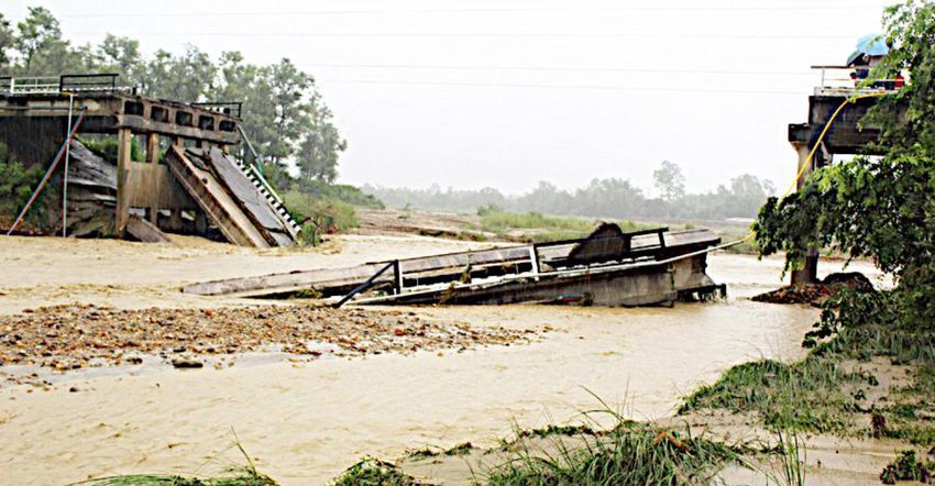
Gurung et al

Other factors are responsible for natural disasters in Nepal: lack of                            (SSRN, 2018). The national roads expanded rapidly from 4,740 km
coordination among agencies related to disaster management, no                                   (blacktop, gravel and earthen) in 1998 to 13,447 km in 2018 (SSRN,
clear-cut job description of those agencies, resource constraint, lack                           2018). These roads are causing landslides, thereby increasing geo-
of technical manpower, lack of public awareness, very remote, rural                              disasters in Nepal (Petley et al., 2007). The built, under-construction
communities, and absence of modern technology (McAdoo et al.,                                    and future road network in Nepal as at fiscal year 2017-2018 is shown
2018). Natural hazards such as landslides and floods are regular                                 in the Strategic Road Network (SRN) map (fig. 1).
phenomenon on the Earth but they turn into disasters when these                                    About 250 to 300 road bridges are built annually across Nepal
affect human beings or destroy their properties and most natural                                 (Department of Roads, Government of Nepal, 2019). However,
disasters are happening due to anthropogenic activities because                                  during every monsoon season (June to September), a considerable
we decide where and how to build our structures/houses (Gurung,                                  number of them are damaged or washed away by geo-hazards (debris
2019).                                                                                           flows, landslides, rock falls) and hydro-hazards (floods), as shown
  According to Rankin et al. (2017) and Sudmeier-Rieux et al. (2019),                            in (fig. 2). This has significant consequences not only for travellers
in the past fifteen years, road and road-bridge construction in Nepal                            but also for local economy, development, and tourism industry.
has topped community and government priorities, a trend likely to                                There is no official data available yet about how many road bridges
continue for many years to come. In 1998, Nepal’s road network was                               get damaged or washed away by geo- and hydro-hazards annually
one of the smallest one in the world with a road density estimated                               across Nepal but, on the basis of information from online national
at 3.22 km per 100 km2 (SSRN, 2018). By 2018, it was increased to                                newspapers, a total of seventeen bridges have been damaged in the
9.14 km per 100 km2 and continues to increase at a very rapid pace                               year 2019 alone, with complete destruction of thirteen road bridges

Fig. 1 – Strategic Road Network Map 2017 – 2018.
1. District headquarter; 2. Black topped road; 3. Gravel road; 4. Earthen road; 5. Planned road; 6. Road under construction; 7. Location of the study area. (Adapted and modified
from: Highway Management Information System and Information Communication Technology (HMIS-ICT Unit), Department of Roads, Government of Nepal, www.dor.gov.
np).
Fig. 1 – Carte du réseau de routes stratégiques en 2017 – 2018.
1. Chef-lieu de district ; 2. Route goudronnée ; 3. Route gravillonnée ; 4. Piste ; 5. Route planifiée ; 6. Route en construction ; 7. Localisation de la zone d’étude. (adaptée et modifiée
de : Système d’Information sur la Gestion des Routes Nationales et Technologie de l’Information et Communication (HMIS-ICT), Département des Routes, Gouvernement du Népal,
www.dor.gov.np).

(tab. 1). Yet a number of bridges, though destroyed or damaged by                                the design and construction of the bridge. Actually, our initial
geo- and hydro-hazards, may not have been reported or published                                  fieldwork was carried out in January 2019, but had to be completed
on newspapers. Bridges can be the most expensive structure along a                               after the May 25, 2019 event, a severe hyper-concentrated flood
road, so it is important to get them right the first time.                                       that destroyed the nearly built GK bridge. Further, we assess and
  The main aim of this study is to analyse the vulnerability of the                              discuss the impacts of floods and landslides along GK catchment
Ghatte Khola (GK) road bridge, – a key area along the Kali Gandaki                               on surrounding settlement, KG road, and KG River. Eventually,
(KG) corridor – in respect to geo-hazards (rock-falls, landslides,                               adapted designs and suitable remedial measures are proposed to
debris flows) and hydro-hazards (floods) of the GK sub-catchment,                                make them as safely as possible, while optimizing the costs and
and whether these have been accounted for correctly during                                       limiting the impacts to property and the environment.

  196                             Géomorphologie : relief, processus, environnement, 2020, vol. 26, n° 3, p. 195-215
River-flow and geo-hazards in Nepal

                                                                                                           Fig. 2 – Destroyed Bhapsi River road bridge
                                                                                                           along the East West highway, Bardibas
                                                                                                           (Mahottari district, east Nepal) by a flash
                                                                                                           flood that occurred on 13rd July 2019.
                                                                                                           (Source: © Sunita Baral, The Kathmandu Post, https://
                                                                                                           kathmandupost.com/national/2019/07/22/).
                                                                                                           Fig. 2 – Pont de la rivière de Bhapsi le long de
                                                                                                           l’autoroute Est-Ouest, à Bardibas (district
                                                                                                           de Mahottari, Népal oriental) détruit par
                                                                                                           une crue soudaine survenue le 13 juillet
                                                                                                           2019.
                                                                                                           (source : © Sunita Baral, The Kathmandu Post,
                                                                                                           https://kathmandupost.com/national/2019/07/22/).

Table 1 – List of damaged road bridges by flash floods and landslides in Nepal in the year 2019.
Tableau 1 – Liste des ponts routiers endommagés par des crues soudaines et des glissements de terrain au Népal en 2019.

       (Source: Online national newspapers)
       (sources : Journaux nationaux en ligne)

                              Géomorphologie : relief, processus, environnement, 2020, vol. 26, n° 3, p. 195-215                                       197
Gurung et al

2. Study area                                                                The GK catchment morphology is controlled by the geology
                                                                           (Upreti and Yoshida, 2005), opposing the biotite-rich, landslide-
  The GK torrential stream appears along the KG road corridor at           prone, mica-schists of the Lesser Himalaya (right bank) to the
Dana (Myagdi) (fig. 3). It is an intermittent, right-bank tributary of     steep quartzites and gneiss rocks of the Higher Himalaya (left
the KG River. The catchment area, 8.4 km 2, has a west-east elongated      bank), with a general N35°-40° dip (Fort, 2014). This asymmetric
shape and extends from the upper ridges at 3,420 m to the confluence       morphology influences the vegetal pattern on the lower, north-
with the KG River at 1,400 m (fig. 4). The average stream gradient is of   exposed hillslopes, in contrast to the south-exposed, steep slope
30°, yet there are sharp contrasts between the upper and lower parts       where bedrock outcrops. Yet, the vegetal cover does not prevent the
of the catchment, with a maximum inclination of approximately 65°          instability of hillslopes.
up to the highest hill, where the channel is at its narrowest. Further       Actually, the GK catchment behaves as a “landslide catchment”
down, the channel inclination decreases to approximately 13° at the        (Starkel, 1976), with pulsating, short debris-flows events initiated
exit of the gorges where the GK torrential stream suddenly widens          in the upper to medium GK catchment (fig. 5), as initially reported
across its fan, with an average slope angle of 7° to 8°. This large,       by Fort (1974). The north facing, dip slope (right bank), probably
distally confined debris fan (~1.5 km wide and ~2 km long), where          a deep-seated gravitational slope according to Chigira et al.
the Dana village and infrastructure are located, encroaches more           (2019), is affected by several planar landslides, reactivated by
than 350 m over the 135 m wide KG floodplain (Fort et al., 2010).          pre-monsoon storms and during monsoon heavy rainfall (fig. 4).
Not dated yet, it is probably not older than Holocene, according to        The GK catchment receives an average annual precipitation of
former regional studies (Monecke et al., 2001; Fort et al., 2010).         1,500 mm (fig. 6A) while it receives a total monsoon rainfall of

                                                                                                     Fig. 3 – Location map of Ghatte Khola (GK)
                                                                                                     torrential stream, Dana (study area), at the
                                                                                                     transition between the Lesser and Higher
                                                                                                     Himalaya (modified after Fort et al., 2010).
                                                                                                     1. Ridges and summits; 2. Glaciers; 3. Major failure
                                                                                                     areas; 4. Landslides; 5. Lacustrine deposits; 6. Fan;
                                                                                                     7. gorges; 8. Perennial stream; 9. Temporary stream;
                                                                                                     10. Settlements; 11. Road.
                                                                                                     Fig. 3 – Carte de localisation de la rivière
                                                                                                     torrentielle Ghatte Khola (GK) et du village
                                                                                                     de Dana (zone d’étude), situé à la transition
                                                                                                     entre le Bas et le Haut Himalaya (modifié de
                                                                                                     Fort et al., 2010).
                                                                                                     1. Crêtes et sommets ; 2. Glaciers ; 3. Zones de
                                                                                                     ruptures majeures de versants ; 4. Glissements de
                                                                                                     terrain ; 5. Dépôts lacustres ; 6. Cône torrentiel ; 7.
                                                                                                     Gorges ; 8. Rivière pérenne ; 9. Rivière temporaire ; 10.
                                                                                                     Villages ; 11. Route.

  198                     Géomorphologie : relief, processus, environnement, 2020, vol. 26, n° 3, p. 195-215
River-flow and geo-hazards in Nepal

                                                                                                 average about once or twice a year, has a high potential to erode
                                                                                                 the stream banks, affecting the cultivated areas on the left bank
                                                                                                 and threatening the water intake feeding the mills (the “Ghatta”,
                                                                                                 Nepali) on the right riverbank. Since the last 12 years however, this
                                                                                                 behaviour may endanger the new KG road, interrupt the traffic
                                                                                                 and destroy the nearby infrastructure and settlements.
                                                                                                   A crucial point is the crossing of the GK channel. When the KG
                                                                                                 road was opened in 2008, an undersized bridge (wet section 42 m 2
                                                                                                 vs 360 m 2 for the natural wet section) was constructed, but it was
                                                                                                 destroyed by a debris flow of moderate magnitude during the first
                                                                                                 monsoon season following road completion (Fort et al., 2010).
                                                                                                 Since the last three years, the road is progressively being upgraded
                                                                                                 to a 2-way tarred road and is going to be a major highway, as an
                                                                                                 annex of the new “Silk Road” that will cross Mustang linking
Fig. 4 – Catchment of Ghatte Khola (GK) torrential stream.                                       Korala Pass (China border) down to Lumbini (Indian border). A
(© N. Gurung, January 2019).                                                                     40-m long road bridge is under construction over the GK torrential
Fig. 4 – Bassin-versant de la rivière torrentielle Ghatte Khola (GK).                            stream where its channel is narrower, near the confluence with the
(© N. Gurung, janvier 2019).                                                                     KG River (fig. 7).

700 to 1,600 mm (fig. 6B). It is often subject to either debris- or                              3. Available data and methods
hyper-concentrated flows affecting the village of Dana and the
KG road. Rainfall data for the hydraulic analysis has been taken                                   This study was conducted by several visits to the GK valley over the
from Tatopani rain-gauge station, which is located ~5 km south                                   period from January to December 2019. The vulnerability of GK road
of GK torrential stream (fig. 3). From time to time, during heavy                                bridge with respect to geo-hazards and hydro-hazards was analysed on
cloudbursts, the landslide masses clog the river flow, where the                                 the basis of (i) site selection, (ii) hydro-geomorphological mapping and
channel bed is at its narrowest (fig. 5). As a result, the water is                              analysis of historical sources, (iii) hydrological analysis, (iv) river cross-
ephemerally blocked by the slide mass, until the water retention                                 sections, (v) hydraulic data, and (vi) sedimentology of channel deposits.
induces a sudden landslide outburst flood (LOF), causing bank                                      (i) The construction of a bridge at poor location can make the
erosion and riverbed widening downstream, all the most efficient                                 bridge more susceptible to failure. Good site selection involves many
along the low alluvial fan (Fort et al., 2010; Fort, 2014). These                                disciplines and includes preliminary engineering, hydrology and
debris- or hyper-concentrated flows of the GK torrential stream are                              hydraulics, geomorphological concerns, roadway alignment, and
abrupt and short: in 1974, it lasted about one hour (Fort, 1974), and                            environmental and geological concerns. All of these topics must be
in May 2019, it lasted about half an hour (based on observations                                 addressed to make sure that the structure is appropriate for the site. The
from local people). Yet such a behaviour of GK, occurring in                                     GK catchment was chosen as study site since it represents a common
                                                                                                 problem that most road bridges in Nepal are experiencing. Further, GK
                                                                                                 torrential stream lies along the KG corridor that links Nepal with Tibet
                                                                                                 (China) under China’s BRI (fig. 3). Finally, the site of the bridge itself
                                                                                                 corresponds to the narrowest part of the channel of the GK.
                                                                                                   (ii) Hydro-geomorphological mapping of GK catchment was prepared
                                                                                                 to spatialise the active-channel dynamics, flooding zones, connectivity
                                                                                                 between the river, and the slopes (fig. 8). A detailed field investigation
                                                                                                 of the GK catchment was performed in January, March, June, October
                                                                                                 and December 2019, including a comprehensive geomorphological
                                                                                                 hazard study and a gathering of information on previous events based
                                                                                                 on available photo and video material, eyewitness reports from the local
                                                                                                 community and silent witnesses detected on-site (geomorphic features,
                                                                                                 traces of flood impacts, etc., as described in Kondolf and Piégay (2003),
                                                                                                 and Arnaud-Fassetta et al. (2009). More specifically, past-events were
                                                                                                 reconstructed from geomorphological mapping (fig. 8), deduced from
Fig. 5 – Focus on Ghatte Khola (GK) upper catchment.                                             field observations, analysis of natural cross-sections, and data provided
Note the sharp contrast between the dip slope (right bank), with active landslides and           by local people in order to have knowledge about past processes and
tension cracks, and the steep, counter-dip slope made of gneisses (© N. Gurung, June             events in GK catchment. Besides, past events (Fort, 1974) and interviews
2019). Potential location for ephemeral dams can be found in the narrow gorge just at
the foot of active landslides.                                                                   with three locals (68 – 70 years old, two from Ligma, one from Dana)
Fig. 5 – Focus sur le bassin-versant supérieur de la Ghatte Khola (GK).                          were also used to prepare geomorphological mapping.
À noter le fort contraste entre la pente parallèle au pendage (rive droite) composée de            (iii) Hydrological analysis is based on the annual rainfall recorded
schistes, avec des glissements de terrain actifs et des fentes de tension, et la pente raide à
contre-pendage sous-tendue de gneiss (© N. Gurung, juin 2019). L’emplacement potentiel
                                                                                                 at Tatopani rainfall gauge station, the only rainfall gauge station at
des blocages éphémères se trouve dans la gorge étroite, juste au pied des glissements de         the proximity (5 km downstream) of the GK catchment. Rainfall
terrain actifs.

                                   Géomorphologie : relief, processus, environnement, 2020, vol. 26, n° 3, p. 195-215                                                  199
Gurung et al

Fig. 6 – Rainfall data measured at Tatopani rain gauge station, located some 5 km south of Ghatte Khola (GK) catchment (see Figure 3).
A: Annual rainfall data (1970-2019). B: Monthly rainfall data (2010-2019; Source: GoN, Department of Hydrology and Meteorology, www.hydrology.gov.np).
Fig. 6 – Données pluviométriques mesurées à la station pluviométrique de Tatopani, située à environ 5 km au sud du bassin-versant de la Ghatte Khola
(GK) (voir Figure 3).
A : Données pluviométriques annuelles (1970-2019). B : Données pluviométriques mensuelles (2010-2019 ; sources : GdN, Département d’hydrologie et de météorologie, www.
hydrology.gov.np).

  200                         Géomorphologie : relief, processus, environnement, 2020, vol. 26, n° 3, p. 195-215
River-flow and geo-hazards in Nepal

                                                                                                     Fig. 7 – Lower part of Ghatte Khola (GK) torrential
                                                                                                     stream, focusing on the GK fan upstream and at
                                                                                                     the confluence with Kali Gandaki (KG) River.
                                                                                                     1. Underconstruction GK bridge; 2. Beni-Jomsom
                                                                                                     road (KG corridor); 3. Cross-section measured
                                                                                                     points (see Figure 12); 4. Sediment sample collected
                                                                                                     points. Note also recent land use changes induced by
                                                                                                     the new road: transmission station, new settlements
                                                                                                     (© N. Gurung, January 2019).
                                                                                                     Fig. 7 – Partie inférieure de la Ghatte Khola
                                                                                                     (GK), montrant le cône de la GK de l’amont
                                                                                                     jusqu’à la confluence avec la rivière Kali
                                                                                                     Gandaki (KG).
                                                                                                     1. Pont de la GK en construction ; 2. Route de
                                                                                                     Beni-Jomsom (KG corridor) ; 3. Sections transversales
                                                                                                     mesurées (voir Figure 12) ; 4. Sites de prélèvements
                                                                                                     d’échantillons. À noter les changements récents
                                                                                                     d’utilisation des sols liés à la nouvelle route : station
                                                                                                     de transformateurs électriques, nouveaux bâtiments
                                                                                                     (© N. Gurung, janvier 2019).

data of fifty years period (1970-2019) have been analysed. The peak       also measured. Furthermore, six places (fig. 7) were chosen for the
discharge of each year for fifty years period was computed based on       measurement of river cross-sections including one along GK road
the maximum rainfall intensity and catchment area by both Rational        bridge to see any changes in river sections, particularly after flash
method and Water and Energy Commission Secretariat (WECS)                 flooding if there occurs any in the GK catchment in future.
method:                                                                     (v) Hydraulic analysis has to be performed to determine the effect of
  In Rational method (Mulvaney, 1851; Kuichling, 1889; Shrestha,          the waterway area on upstream floodwater elevations of a bridge (fig.
2008; Rijal, 2014), discharge was computed by using empirical             9). Hydraulic data, mainly linear waterway and high flood level were
formula, i.e., Q = CIA, where Q is the design flow (in m3/s), I is the    computed for both extreme and average discharges of GK torrential
rainfall intensity (in mm/h), A is the catchment area (in km2), and       stream (the margin of error for the measurements is plus or minus
C is the run-off coefficient. In the GK catchment, A = 8.4 km2 = 8.4 x    10%). Linear water way was computed using Lacey’s empirical formula
106 m2, C = 0.3 (as the catchment is vegetated), and for the different    (1958), W = 4.75√Q, where W is waterway (in m) and Q is discharge
rainfall intensity for each year, Q was computed for both peak and        (in m3/s). The freeboard was computed by HEC–RAS analysis,
annual rainfall intensity.                                                which integrates the river geometry (river cross-sections and L, river
  Water and Energy Commission Secretariat (WECS) method                   longitudinal profile) and hydraulic data (discharge). HEC–RAS is a
(WECS/DHM, 1990) was developed for estimating the peak flow of            system software, which is capable of performing one dimensional
the ungauged catchments of Nepal. The regression equations, which         steady flow analysis (for gradually varied flow) among many other
have been proposed to estimate instantaneous flood of 2-year and          capabilities (HEC–RAS, 2016). River geometry, roughness coefficient,
100-year return periods by WECS, have been modified by Sharma             and flood discharge are three important parameters for the hydraulic
and Adhikari (2004) based on long-term data. They proposed the            modelling in HEC–RAS.
following equations for instantaneous peak-flow estimation. For             Since detailed historical data on flood are not available in GK
2-year return period, Q2 = 2.29A0.86 and for 100-year return period,      catchment, they were derived from available precipitation data.
Q100 = 20.7A0.72, where Q is the discharge (in m3/s), and A is the        Water and Energy Commission Secretariat (WECS) method and
catchment area (in km2). A 100-year return period is often taken to       Rational method were used to estimate the design flood. In the
design major bridges in Nepal, hence only Q100 was computed by this       hydraulic modelling of the GK torrential stream, channel geometry
method.                                                                   parameters were measured directly from the field survey. Since GK
  It is common practise for the design of bridges on ungauged rivers      is a mountainous steep stream with boulders, Manning’s roughness
in Nepal to run the calculations with both methods. Subsequently,         coefficient was assumed to be 0.05 based on the river-bed material
the higher values provided by one of the methods are used for             and mixed flow regime (Arcement and Schneider, 1989).
hydrological analysis. In this study, the higher values provided by         With the available data, a steady flow model was constructed
Rational method were used, considering for the worst cases scenarios      with energy gradient as a boundary condition and the flow
since these give extreme discharges in the river. The bridge should       assumed to be as a mixed regime because the bed slope is variable
be able to pass all extreme flood discharges safely through it that are   and is expected to encounter both sub-critical and super-critical
likely to occur in the river.                                             flow. For mixed flow regime, steady flow model requires boundary
  (iv) River cross-sections were measured (with a margin of error of      conditions at both ends of the model, and from the longitudinal
± 10%) to perform hydrological analysis in HEC–RAS (2016) and to          river profile, slope of the river bed So at upstream and downstream
compute hydraulic data required for the design of a road bridge. A        ends was measured to be 0.052118 and 0.081339 respectively. After
total of thirty cross-sections were taken along 1.5 km length at 50 m     the construction of the steady flow model, it was run combining
intervals and a longitudinal section of the GK torrential stream were     all the parameters (geometry, flow and boundary conditions). The

                          Géomorphologie : relief, processus, environnement, 2020, vol. 26, n° 3, p. 195-215                                        201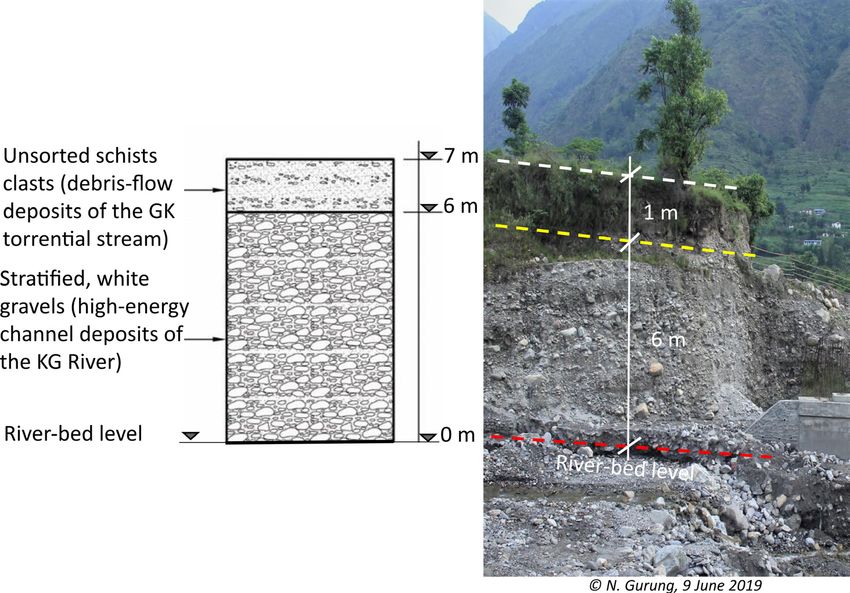
Gurung et al

                                                                                                         Fig. 8 – Geomorphological map of
                                                                                                         Ghatte Khola (GK) catchment.
                                                                                                         A: Location (Adapted from Fort et al.,
                                                                                                         2010). 1. Stream; 2: catchment boundary; 3.
                                                                                                         Structural scarp; 4. Cornices; 5. Foliation
                                                                                                         dip. B: Detail of the catchment. 1. Houses;
                                                                                                         2. Gully; 3. Ghatte Khola; 4. Ghatte Khola
                                                                                                         motor bridge; 5: Beni-Jomsom road (Kali
                                                                                                         Gandaki Corridor); 6. Channel deposits
                                                                                                         (flood plain of Ghatte Khola); 7. Kali
                                                                                                         Gandaki River; 8. Landslide; 9. Lower
                                                                                                         terrace (flood plains of Kali Gandaki and
                                                                                                         Ghatte Khola); 10. Medium fan-terrace;
                                                                                                         11. Higher fan-terrace; 12. Ghatte Khola
                                                                                                         ephemeral cone. The landslides developing
                                                                                                         on the left-bank slope are episodically
                                                                                                         active, and their mass may ephemerally
                                                                                                         block the very narrow stream bed (see also
                                                                                                         Figure 4 and 5).
                                                                                                         Fig. 8 – Carte géomorphologique du
                                                                                                         bassin-versant de la Ghatte Khola
                                                                                                         (GK).
                                                                                                         A : Localisation (adaptée de Fort et al.,
                                                                                                         2010). 1. Rivière torrentielle ; 2. Limites du
                                                                                                         bassin-versant ; 3. Escarpement structural
                                                                                                         ; 4. Corniche ; 5. Pendage de la foliation.
                                                                                                         B : Détail du bassin-versant. 1. Maisons ;
                                                                                                         2. Ravin ; 3. Ghatte Khola ; 4. Pont routier
                                                                                                         de la Ghatte Khola ; 5. Route Beni-Jomsom
                                                                                                         (corridor de la Kali Gandaki) ; 6. Dépôts
                                                                                                         du chenal (lit majeur de la Ghatte Khola)
                                                                                                         ; 7. Rivière Kali Gandaki ; 8. Glissement de
                                                                                                         terrain ; 9. Basse terrasse (lits majeurs de
                                                                                                         la Kali Gandaki et de la Ghatte Khola) ;
                                                                                                         10. Cône-terrasse moyen ; 11. Haut
                                                                                                         cône-terrasse ; 12. Cône éphémère de la
                                                                                                         Ghatte Khola. Les glissements de terrain
                                                                                                         qui se développent sur le versant de rive
                                                                                                         gauche sont épisodiquement actifs, et leur
                                                                                                         masse peut bloquer de façon éphémère le
                                                                                                         lit très étroit du cours d’eau (voir également
                                                                                                         Figure 4 et 5).

model finally generated water surface elevations (free board) at        along GK torrential stream (fig. 7). Lab tests (sieve analysis) were
different cross-sections including the GK bridge section, which was     performed at the lab of Tribhuvan University, Paschimanchal
the main matter of concern for this study. Fr is the Froude number,     Campus, Pokhara, to determine, by the percentage of fine matrix
which demarcates the flow regime, whether it is subcritical (Fr > 1)    sediment (FMS), the type of hydro-morphological event (i.e., the
or supercritical (Fr < 1). The model was run with the flow regime       transport mode: torrential: FMS < 40%; hyper-concentrated flow:
to be as supercritical flow regime, boundary condition is required      40% < FMS < 60%; debris flow: FMS > 60%).
only at the upstream end, the value of which is equal to the slope of
the energy grade line and that was computed to be Se = 0.052153.        4. Results
  Highest water surface profiles were calculated with the Rational
method at different magnitudes of extreme flood discharges. The          4.1. Before the event of May 25, 2019
HEC – RAS model was also run for average flood discharges to see
whether the high-flood-water level rises above the GK road bridge          4.1.1. A catchment prone to landslides and flooding
level or not. Further, highest water surface profiles were calculated
at different magnitudes of average flood discharges.                      The geomorphological map (fig. 8) shows that both GK road
  The sufficient scouring depth under the GK bridge was estimated       bridge and KG road have been built on the complex of GK fan
according to Indian Road Congress (2000), where average                 terrace – KG f luvial terrace (i.e., the medium one), which is
scouring depth was given by: Dsm = 1.34 (q2/f )0.33 (Lacey, 1958)       prone to extreme f looding in both rivers KG and GK. It means
where q = (Q/W) = (design flow/waterway of bridge), f = 1.76√dm         that extreme f looding either in GK or KG may have serious
(Lacey’s silt factor), and dm = mean size of bed material.              damage on GK road and bridge. Furthermore, dominating
  (vi) Sedimentology of channel deposits lead us to specify the         mass movements (planar to complex and rotational landslides)
origin, transport, and deposition of the materials that compose         at their respective source areas were identified along the right
the sediment layers at GK bridge site with its stratigraphic            bank of GK in the upper catchment of GK (fig. 8). In its lower
sketch. The goal is to understand the sedimentology of deposited        part, the higher terrace of GK torrential stream consists mainly
materials and how good these materials are for the bridge               of alluvial, whitish (gneissic) material by KG River, as seen on the
foundation. Debris samples were collected from different places         opposite Garpar village, overtopped by GK, mud-supported dark

 202                     Géomorphologie : relief, processus, environnement, 2020, vol. 26, n° 3, p. 195-215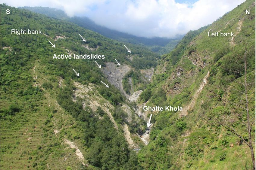
River-flow and geo-hazards in Nepal

debris. The medium terrace of GK fan is cut into the KG gravels                                 River during f loods, as in 1974 (Fort, 1974, 2014). In the worst
and filled with 1-to-2 m thick debris f low material deposited                                  scenario, f looding may take place at the same time in both GK
by GK flood events (fig. 10). The lower fan-terrace of GK is a                                  torrential stream and KG River, which may partly inundate the
cone built by recent (a few decades) GK debris f low events at the                              lower fan-terrace and medium terrace of GK fan. Part of the GK
junction with KG. Indeed, the KG River has potential to block                                   road bridge lies on the medium terrace (fig. 8).
GK torrential stream, which has also equal potential to block KG

Fig. 9 – Design of the 40 m long under construction road bridge across the Ghatte Khola (GK) torrential stream.
(Source: Adapted and modified from Kali Gandaki (KG) Road Corridor Project, Department of Road, Nepal Government). The depth of the abutments below the river-bed level
is 2.82 m. The high-flood level (HFL) shown here is only 1.5 m (1,319.79 minus 1,318.29) above the river-bed level, which is much less than the HFL from HEC–RAS analysis for
extreme floods (see Figure 17).
Fig. 9 – Plan du pont routier de 40 m de long en construction sur le torrent de la Ghatte Khola (GK).
(sources : adapté et modifié de Kali Gandaki (KG) Road Corridor Project, Department of Road, Nepal Government). La profondeur des culées sous le niveau du lit de la rivière
torrentielle est de 2,82 m. Le niveau de crue (HFL) indiqué ici n’est que de 1,5 m (1 319,79 moins 1 318,29) au-dessus du niveau du lit de la rivière, ce qui est bien inférieur au HFL de
l’analyse HEC–RAS pour les crues extrêmes (voir Figure 17).

    4.1.2. Historical frequency of flood-events                                                 f low since the deposit consisted of some 50% to 54% fine (less
                                                                                                than 2 mm in size) and 40% to 46% coarser materials (fig. 11).
  From the interviews with elderly local people, it was learnt
that flooding in GK catchment is a repeated event and is taking                                     4.2.1. Change on river cross-sections due to the flooding event
place since their memory (70 years). The largest flooding in GK
catchment to their living memory, had taken place about 50 years                                  Results from the comparison of the six river cross-sections along
ago (AD 1971), the debris of which had covered both lower and                                   the fan (fig. 7, 12) before and after the May 25, 2019 flooding event
medium terraces of GK fan and even to some areas of higher                                      (Gurung et al., 2019a, b) are given in the following and in (tab. 2). Along
terrace along GK bank (fig. 8) killing 45 goats, 10 buffaloes, 6 cows,                          section A, we observed deposition of debris on the left bank and up to
and 7 people. That means the location where GK road and bridge                                  the flow area, then erosion at flow area, whereas along section B, some
are built, is vulnerable to future extreme floods, hence extreme                                deposition took place on the left bank and scouring at flow section, thus
precautions need to be taken for this for infrastructure projects                               the river-bed level was lowered and, the channel width was increased at
like bridge or road.                                                                            flow section. Along section C, we observed deposition on the left bank
                                                                                                (up to 0.5 m) and scouring at flow section on the right bank, thus the
  4.2. The event of May 25, 2019                                                                river-bed level was lowered and, the channel width was increased at
                                                                                                flow section. Along section D, scouring at flow section occurred, so that
  Like previous flash-f lood events (Fort, 1974; Fort et al., 2010),                            the river-bed level was lowered and, the channel width was increased
the flood event of May 25, 2019 in GK catchment was triggered                                   at flow section. Similarly, along section E, scouring (approximately by
by heavy cloudburst (>16 mm/h) and LOFs. According to Dahal                                     1 m) developed on the left bank including flow section, thus the river-
and Hasegawa (2008), a rainfall intensity of 12 mm/h is sufficient                              bed level was lowered. Along the GK road bridge section F, we observed
to trigger landslides in Nepal for rainfall events of less than                                 deposition on the left bank, with a water flow (max. 0.5 m height) and
10 h, while an average precipitation of less than 2 mm/h appears                                significant deposition on the right bank from the river flow (up to 3 m
sufficient to cause landslides if continued for more than 4 days.                               thick), so that the river-bed level was significantly upgraded.
Further, an eyewitness (a local from Ligma who was present                                        During the flash flood of May 25, 2019, both erosion and deposition
on that time at the upper catchment of GK herding his goats)                                    were observed at upstream and middle sections (fig. 12A-C) of GK
narrates that there was a breaching of landslide-dammed lakes                                   torrential stream. Erosion predominated upstream from the bridge
at least at two places with a big sound at the upper catchment of                               (fig. 12D-E) and, as the hyper-concentrated flow reached the narrow
GK on May 25. The May 25, 2019 f lood was a hyper-concentrated                                  section close to the confluence, more aggradation was evident (fig.

                                 Géomorphologie : relief, processus, environnement, 2020, vol. 26, n° 3, p. 195-215                                                              203
Gurung et al
Fig. 10 – Stratigraphic section
along the left-bank Ghatte Khola
(GK) bridge alignment.
Fig. 10 – Coupe stratigraphique
du cône observée en rive gauche,
à proximité du pont de la Ghatte
Khola (GK).
12F). Eventually, during this event, we estimate that a total of 16,050 m3 the washing away of the GK bridge (fig. 14), the highest water level
(± 1,605 m3) of debris were eroded while a volume of about 18,100 m3 might not have reached the deck level of this under-construction
(± 1,810 m3) of debris was deposited in the lower GK catchment. bridge. The failure of the GK bridge does not seem to be due to the
Just upstream of the bridge, the flow is sub-critical with lower velocity extreme flood discharges, but more likely to the restriction of river
and less energy. However, at the downstream side of the bridge, the flow by the temporary scaffolding work (fig. 15).
scenario is just opposite with wider available waterway for the flood
water to pass. Consequently, the flow is super-critical, with high velocity 4.3. After the event of May 25, 2019
of 11.24 m/s and energy grade line as high as 8.44 m. The deduced
water surface from HEC – RAS led to check the design adequacy of the 4.3.1. The engineering works
under-construction road bridge over the GK torrential stream.
The GK bridge construction (fig. 9) started in March 2018. During
4.2.2. Damage to the under-construction GK road bridge the flood of May 25, 2019, the bridge was washed away when it was
on the verge of completion. In fact, its destruction was due to the
The flash flood destroyed the nearly completed GK road bridge poor engineering works carried out at wrong time. The waterway
(fig. 13). It was unfortunate to lose the bridge but this was not an was almost blocked by scaffolding work and only a small hume
unexpected event. There is no record of the highest flood level that pipe of 70 cm in diameter was laid for the water flow (fig. 15). It
reached that bridge but, based on the photo taken few minutes after was sustainable as long as there was no flood. Since the work was
Fig. 11 – Sieve-analysis of debris samples
collected from Ghatte Khola (GK) torrential
stream.
50% to 54% are fine and 40% to 46% are coarse
materials than 2 mm size, thus confirming to a
hyper-concentrated flow.
Fig. 11 – Analyse par tamisage des
échantillons de débris prélevés dans le
torrent de la Ghatte Khola (GK).
50 % à 54 % des débris sont fins et 40 % à 46 % sont
des débris grossiers de plus de 2 mm, ce qui confirme
une mise en place par un écoulement hyperconcentré.
204 Géomorphologie : relief, processus, environnement, 2020, vol. 26, n° 3, p. 195-215River-flow and geo-hazards in Nepal
Fig. 12 – Comparison of six cross-sections (for locations, see Figure 7) of the Ghatte Khola (GK) torrential stream.
The measurements were recorded on 2 March 2019 and 15 June 2019, hence before and after the May 25, 2019 flood event respectively. 1. Dark unsorted schists clasts (hyper-
concentrated flow deposits of the GK River); 2. Pre-May 25 event river bed.
Fig. 12 – Comparaison de six sections transversales de la rivière torrentielle Ghatte Khola (GK ; voir la Figure 7 pour la localisation des sections).
Les mesures ont été faites le 2 mars 2019 et le 15 juin 2019, donc respectivement avant et après la crue du 25 mai 2019. 1. Débris de schistes sombres non triés (dépôts d’écoulements
hyperconcentrés de la GK) ; 2. Lit du torrent avant la crue du 25 mai 2019.
Géomorphologie : relief, processus, environnement, 2020, vol. 26, n° 3, p. 195-215 205Gurung et al
Table 2 – Estimation of areas and volumes of sediments deposited and/or eroded during the May 25, 2019 Ghatte Khola flood event as observed at the
six cross-sections (location on Figure 7).
Table 2 – Estimation des superficies et volumes de sédiments déposés et/ou érodés pendant la crue de la Ghatte Khola du 25 mai 2019 au niveau des six
sections (localisation sur la Figure 7).
being done in May, the season of cloudbursts in Nepal, floods were
not unexpected at that period and, in the specific case of GK, in the
form of a destructive LOF. Without the landslide activity it might
have been a smaller flood causing no serious damage to the bridge.
The reconstruction work of GK bridge started from November
2019 but despite the huge loss of May 2019 flooding, the work
was resumed without any change on the original design and any
consideration of river-flow dynamics in GK catchment. (i) In spite
of the fact that GK receives recurrent flash foods once or twice a
year, the present GK bridge design did not include sufficient river-
bank protection works. (ii) We also noted that no adequate flood
protection countermeasures were constructed to safeguard the
bridge structure. The gabion baskets used as bank protection along
GK were poorly designed and installed, with a lack of enough
preventive maintenance, so that most gabion basket structures
collapsed during monsoon flood (fig. 16). Due to the low-bank height
and loose-bank materials, there is a strong possibility that future
floods in GK might again encroach over the fields and settlements
upstream from the bridge (fig. 7A-E). (iii) Further the existing bridge
site consists of loose KG River deposited materials overlain by GK
debris flows (fig. 10), both prone to river erosion and yet, both bridge
abutments of GK bridge are on shallow foundation.
The newly built GK bridge is now on the finishing stage (fig. 15).
Since it is built close to the confluence with KG River, more
aggradation is likely to occur on the GK bridge site such as during
the May 25, 2019 flooding (fig. 12F). It means that the present
free-board (~3 m) of the GK bridge above the river bed is likely to
decrease due to possible aggradation processes at GK bridge section.
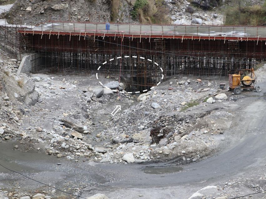
Fig. 13 – Under construction Ghatte Khola (GK) bridge. In addition, the present cavity (fig. 15) will be refilled when the
A: Before the May 25, 2019 flood event (© N. Gurung, 2 March 2019). B: After the bridge is completed.
May 25, 2019 flood event (© N. Gurung, 15 June 2019). These two photos clearly show,
behind the left bank abutment, the section on display, with the > 6 m thick whitish
stratified gravels of the Kali Gandaki (KG) alluvions (at the bottom) overtopped by 4.3.2. Hydromorphological assessment of engineering works
darker, unsorted schists clasts of the GK torrential stream (1-m thick).
Fig. 13 – Pont de la Ghatte Khola (GK) en construction. First, insufficient linear waterway is observed. From hydrological
A : Avant les inondations du 25 mai 2019 (© N. Gurung, 2 mars 2019). B : Après la crue analysis, the linear water way (clear distance between bridge
du 25 mai 2019 (© N. Gurung, 15 juin 2019). Ces deux photos montrent clairement,
derrière la culée de la rive gauche, la section exposée, avec en bas les graviers stratifiés abutments) of the under construction GK road bridge was computed
blanchâtres de plus de 6 m d’épaisseur des alluvions de la Kali Gandaki (KG), recouverts to be 36 to 48 m (tab. 3) for 100 years return period for extreme flood
par les alluvions torrentielles de la GK, fragments de schistes plus sombres et non triés
(1 m d’épaisseur). discharges of 50 years (1970-2019). The provided linear water way of
206 Géomorphologie : relief, processus, environnement, 2020, vol. 26, n° 3, p. 195-215River-flow and geo-hazards in Nepal
Fig. 14 – Flash flood of 25 May 2019.
The photo was taken some 20 minutes after the washing away of the under-construction
Ghatte Khola (GK) bridge (© R. Burathoki, 25 May 2019).
Fig. 14 – Crue éclair du 25 mai 2019.
La photo a été prise environ 20 minutes après que le pont de la Ghatte Khola (GK) en Fig. 15 – The new Ghatte Khola (GK) bridge under reconstruction, with
cours de construction ait été emporté (© R. Burathoki, 25 mai 2019).
scaffolding work.
The encircled area was the only way open for river flow at the time of the May 25, 2019
flash flood. The bridge here is seen on curing stage (© N. Gurung, 21 March 2020)
Fig. 15 – Le nouveau pont de la Ghatte Khola (GK) en reconstruction, avec
travaux d’échafaudage.
La zone encerclée était le seul passage ouvert pour l’écoulement de la rivière au moment
de la crue éclair du 25 mai 2019. Le pont est en phase de réparation (© N. Gurung, 21
mars 2020).
Fig. 16 – Stream bank protections.
A: Gabion wall damaged by the monsoon flood, left bank of Ghatte Khola (GK) torrential stream, between sections E and F of Figure 12 (© N. Gurung, 15 June 2019). B: Sketch of
the proposed gabion wall with reno-mattress on the foundation. The length of reno-mattress (L) should be minimum 1.5x to 2x the scouring depth and the depth of foundation
should be below the scouring depth (Source: Adapted and modified from Enviromesh Gabions – Designing with Gabions and Mattresses, 2007).
Fig. 16 – Protection des berges des cours d’eau.
A : Mur de gabions endommagés par la crue de pré-mousson, en rive gauche de la Ghatte Khola (GK), entre les sections E et F de la Figure 12 (© N. Gurung, 15 juin 2019). B : Croquis
du mur en gabions proposé avec un matelas de renfort sur les fondations. La longueur du matelas de renfort (L) doit être au minimum de 1,5 à 2 fois la profondeur d’affouillement
alors que la profondeur de la fondation doit être inférieure à la profondeur d’affouillement (sources : adaptée et modifiée de Enviromesh Gabions – Designing with Gabions and
Mattresses, 2007).
GK road bridge is 38 m (fig. 9). From Table 3, the computed linear seem vulnerable to future extreme floods. But the GK road bridge
water way is less than 38 m for seven particular years out of total was found to be safe for average flood discharges (calculated based
fifty years. That means the linear water way of GK road bridge does on the average rainfall data of all 12 months of a year) since the
seem to be sufficient only for seven times out of fifty years’ extreme linear water way for average flood events was computed to be 33.63
flood events (extreme flood discharges are computed based on the to 37.81 m, which is less than the provided water way, i.e., 38 m
extreme rainfall data of all 12 months of a year). In another word, (tab. 4). Hence the under construction GK road bridge does seem
the provided linear waterway is insufficient to allow extreme flood safe to future normal/average floods.
discharges safely for forty-three times out of fifty (86%) extreme Though this analysis shows that the linear water way of GK bridge
flood events, hence the under construction GK road bridge does was found to be insufficient in more than 80% cases, this may not
Géomorphologie : relief, processus, environnement, 2020, vol. 26, n° 3, p. 195-215 207Gurung et al Table 3 – Hydraulic computation for Ghatte Khola (GK) for extreme discharge for 100 years return period using rainfall data from 1970 to 2019. Tableau 3 – Calcul hydraulique, pour la Ghatte Khola (GK), du débit extrême pour une période de retour de 100 ans en utilisant les données de précipitations de 1970 à 2019. The provided waterway for the GK road bridge is 38 m. La voie d’eau prévue pour le pont routier de la GK est de 38 m. 208 Géomorphologie : relief, processus, environnement, 2020, vol. 26, n° 3, p. 195-215
River-flow and geo-hazards in Nepal

Table 4 – Hydraulic computation for Ghatte Khola (GK) for average discharge for 100-years return period using rainfall data from 1970 to 2019.
Tableau 4 – Calcul hydraulique, pour la Ghatte Khola (GK), du débit moyen pour une période de retour de 100 ans en utilisant les données de précipitations
de 1970 à 2019.

The provided waterway for the GK road bridge is 38 m.
La voie d’eau prévue pour le pont routier de la GK est de 38 m.

                                 Géomorphologie : relief, processus, environnement, 2020, vol. 26, n° 3, p. 195-215                                209
Gurung et al
be truly applicable on the field. Furthermore, this approach may computed highest water-surface elevation for extreme flood discharge
underestimate the discharge of flash floods since hyper-concentred at the bridge location is 122.52 m, which is 1.52 m (122.52 m minus
flows, which often develop with run-off discharge during flash 121.00 m) above the bottom level of the deck. This means that the flow
floods in GK, has not been taken into consideration. Since the linear is obstructed at this location due to the insufficient flow area to safely
waterway is directly proportional to flood discharge, hence the pass the extreme flood discharge. The major cause of the damage of the
probability of bridge damage may even be more than the computed bridge could be (i) the constriction in flow area required for the safe
here. Furthermore, since the linear water way is insufficient by 10 m discharge of extreme flood, and (ii) the large amount of debris that may
at the max. (48 m vs 38 m) that is some 26% more than the provided have come along with the flow at the time of flood event.
water-way (38 m), it does not mean that the bridge gets damaged or Furthermore, for annual flood discharges in GK, the computed high-
will be washed way. This will lead to increase the bank-erosion process water-surface elevation at the bridge location of 100 years’ return period
and rise on high-flood level at the bridge section and thus may have an was found to be below the deck level of the under-construction GK road
adverse effect on the function of the bridge. bridge. The computed highest water surface elevation for annual flood
Secondly, insufficient free-board is observed. In HEC-RAS analysis, discharge is 119.89 m level, which is 1.11 m (121.00 m minus 119.89 m)
the highest flood level of 100 years’ return period in GK catchment for below the bottom level of deck of the under-construction GK road
extreme flood discharges was found to have overtopped the bridge i.e. bridge, therefore the GK road bridge could be safe for annual flood
above the deck level of the under-construction GK road bridge, hence discharges (fig. 18). Department of Roads, Government of Nepal (2010)
the GK road bridge is at high risk from potential flooding (fig. 17). The has recommended a minimum free-board of 1 m for the discharge
Fig. 17 – Modelling in HEC – RAS software
(version 5.0.3) for Ghatte Khola (GK)
extreme flood discharges at the section
where the road bridge is being built (see
Figure 7, section F).
1. Stream cross-section; 2. High-flood level; 3.
Flood. The top level (deck of the bridge) at the bridge
section is at 122.30 m and its bottom is at 121.00 m,
while from HEC–RAS analysis, the highest water
level reaches to 119.89 m, which is 1.11 m (121.00 m
minus 119.89 m) below the bottom deck level of the
bridge.
Fig. 17 – Modélisation avec le logiciel HEC
– RAS (version 5.0.3) des débits de crue
extrêmes de la Ghatte Khola (GK) au niveau
de la section du pont routier en cours de
construction (voir la Figure 7, section F).
1. Section en travers de la rivière ; 2. Niveau des
hautes eaux ; 3. Crue. Le niveau supérieur (tablier
du pont) de la section du pont se situe à 122,30 m et
son niveau inférieur à 121,00 m, tandis que d’après
l’analyse HEC–RAS, le niveau d’eau le plus élevé
atteint 119,89 m, soit 1,11 m (121,00 m moins 119,89
m) en dessous du niveau du tablier inférieur du pont.
Fig. 18 – Modelling in HEC – RAS software
(version 5.0.3) for Ghatte Khola (GK)
average flood discharges at section where
the road bridge is being built (see Figure 7,
section F).
1. Stream cross-section; 2. High-flood level; 3.
Flood. The top level (deck of the bridge) at the bridge
section is at 122.30 m and its bottom is at 121.00 m,
while from HEC–RAS analysis, the highest water
level reaches to 119.89 m, which is 1.11 m (121.00 m
minus 119.89 m) below the bottom deck level of the
bridge.
Fig. 18 – Modélisation avec le logiciel HEC
– RAS (version 5.0.3) des débits de crue
moyens de la Ghatte Khola (GK) au niveau
de la section du pont routier en cours de
construction (voir la Figure 7, section F).
1. Section en travers de la rivière ; 2. Niveau des
hautes eaux ; 3. Crue. Le niveau supérieur (tablier
du pont) de la section du pont se situe à 122,30 m et
son niveau inférieur à 121,00 m, tandis que d'après
l'analyse HEC–RAS, le niveau d'eau le plus élevé
atteint 119,89 m, soit 1,11 m (121,00 m moins 119,89
m) en dessous du niveau du tablier inférieur du pont.
210 Géomorphologie : relief, processus, environnement, 2020, vol. 26, n° 3, p. 195-215River-flow and geo-hazards in Nepal
up to 200 m3/s, hence the free-board of GK bridge for annual flood by Lebbe et al. (2014), majority of bridges in Queensland, Australia
does seem to be sufficient. However, we have to qualify this as strictly were damaged and failed due to the flood since the waterway and
hydraulic results. Floods, even those that occur every year, are hyper- freeboard of bridges were not sufficient to safely pass the high flood.
concentred flows that progress downstream as hydro-sedimentary The situation is not different in Nepal too.
waves. These waves are able to block the bridge, especially as the GK At least seventeen bridges got damaged (thirteen completely
channel width is reduced downstream due to anthropogenic forcing destroyed) by floods and landslides in Nepal in 2019 (tab. 1). Three
(hydraulic deflectors, dikes, walls, roads). We confirm here that the of them (18%) were under construction indicating that the potential
management of a mountain stream is not only to be concerned with onset of natural hazard events was not carefully considered in timing
the water heights but also with the sediments they carry which play an the construction of the bridges. Further investigations on destroyed
important role to change the 3D geometry of the riverbed. under-construction bridges are necessary to better evaluate the
Finally, sufficient scouring depth is required. The most common extent of this issue. However, considering geo-hazards and river-
cause of bridge failures is scouring of bridge piers and abutments by flow dynamics is essential not only for individually designing
river flow, hence the bridges should be designed to withstand scouring safe and sustainable bridges but also for carefully scheduling the
from large floods and from stream instabilities expected over the life construction of the bridges. From GK bridge study, it is clear that
of a bridge. According to Indian Road Congress (2000), the average the bridge is not designed and built up to the standard considering
scour depth in a bridge (Dsm) is given by Dsm = 1.34(q2/f)0.33. Here geo-hazards and river-flow dynamics in particular. As mentioned
q = Q/W = design flow/waterway of bridge, f = 1.76 dm, with dm = mean by Reed (2015) for whom historical floods are often overlooked in
size of bed material. For the extreme flood, Q = 100.74 m3/s (discharge river-flood risk assessment, past flood events are rarely considered
of 2003, see Table 4), W = 38 m waterway, and dm = 1.1 m; the average during the design of road bridges in Nepal and GK bridge is not an
scour depth (Dsm) was computed to be 1.7 m. Further, the maximum exception.
scour depth for bridge abutments (Indian Road Congress, 2000) Hearn (2002) had stated that the wider use of engineering
is = 1.27Dsm = 1.27 x 1.7 = 2.16 m. But the provided scour depth of geomorphology in Nepal has been disappointingly low and
the under-construction GK bridge is 2.82 m (fig. 9). Hence the under- there are instances where a lack of engineering geological or
construction GK bridge was found to have sufficient scouring depth. geomorphological appreciation has led to recurrent problems,
leading to modifications of design and even alignment of road and
5. Discussion bridges. Even today after 18 years of Hearn’s statement, it still looks
valid since bad news about the damage to roads and road bridges
5.1. Flash floods and river-training works by floods and landslides, especially during monsoon season, remain
common in Nepal. River hydrology and geomorphology are often
Flash floods are not unexpected events in GK catchment and the overlooked in the design phase, which might lead to the failure
flash flood that occurred on May 25, 2019 is just an example of this of bridges. The GK road bridge is just a representative case where
type of event. In the future, many such floods are expected to occur catchment geo-hazards and river-flow dynamics in particular are
in this catchment and these may have the same or more effects on not sufficiently incorporated in the design. This does not necessary
river cross-sections, depending on their magnitude. Therefore, all mean that the GK bridge would be washed away by floods in near
engineering structures and settlements must be built according to the future because though the GK bridge is vulnerable to extreme
dynamic behaviour of GK torrential stream. The under-construction floods, the bridge yet looks safe for average flood discharges.
GK bridge is vulnerable to future extreme floods, though it still Furthermore, a completely no-failure design could be exceedingly
looks safe for average floods. The present conventional bank-erosion costly. The cost of under-construction GK road bridge is US$
protection works (Steel wire Gabion box retaining wall) along GK 405,000. A question can be discussed whether such a costly
seem to be inadequate to deal with the scale of erosion that eventually bridge over GK River was necessary or not because it is true that
takes place during pre- or monsoon flash floods (fig. 16A). Every GK catchment receives flash floods on few occasions of the year
year, during monsoon, gabion walls are failed by high flows in GK and most of the time, the stream remains dry. On this aspect, the
and shall be re-built before the next monsoon in order to protect under-construction GK bridge does not look economically viable,
river bank erosion. But this is simply not making worth. Since GK in contrast to inexpensive, low-water crossings such as concrete
banks consist of alluvial deposited loose boulders or clasts mixed fords, as could have been planned and carefully designed along the
sandy gravel matrix, they are easily erodible by river, hence a proper present road, just upstream from the GK road bridge (fig. 19). In
retaining structure with reno-mattress, i.e., engineering structures fact, concrete fords are easier and quicker to repair or build even if
built at river bed level to prevent retaining walls from scouring, is they get damaged or washed away in flash floods. Though ford-type
recommended (fig. 16B). structures imply some periodic or occasional traffic delays during
periods of high flow, it takes no more than a week to repair or clean
5.2. Safe design of bridges facing flood hazard them off and the traffic can be resumed. But when a bridge is broken,
it takes months to rebuild. Furthermore, since GK flow stops the
A study by Wardhana and Hadipriono (2003), which investigated traffic only for few occasions of the year, building a ford would have
about 500 cases of bridge destruction that occurred in the USA been a better option both economically and functionally than an
between 1989 and 2000, revealed that flood-associated hydraulic expensive yet vulnerable road bridge. There are many fords built
factors, such as insufficient waterway, freeboard and scouring were along KG corridor (between Kushma and Beni), which are serving
the most common causes of bridge destruction. In another study well.
Géomorphologie : relief, processus, environnement, 2020, vol. 26, n° 3, p. 195-215 211You can also read