North Coast Regional Water Quality Control Board - State Water ...
←
→
Page content transcription
If your browser does not render page correctly, please read the page content below
North Coast Regional Water Quality Control Board

         California Regional Water Quality Control Board
                       North Coast Region
                   Resolution No. R1-2021-0017
                            Approving
     The Elk River Restoration Project as an Exemption to the
Enclosed Bays and Estuaries Policy Prohibiting Waste Discharges to
                          Humboldt Bay
                        Humboldt County

WHEREAS the California Regional Water Quality Control Board, North Coast Region,
(hereinafter “Regional Water Board”) finds that:

1. The City of Eureka (Permittee) owns and operates the Elk River Wastewater
   Treatment Plant (Facility) that was commissioned in June of 1984. The Facility
   discharges secondary treated effluent via a 48-inch diameter pipe, 4,100 feet in
   length, and equipped with a multiple port diffuser to Humboldt Bay, an enclosed bay,
   and a water of the United States.

2. The State Water Resources Control Board adopted Resolution No. 74-43, the Water
   Quality Control Policy for the Enclosed Bays and Estuaries of California (Policy), on
   May 16, 1974. The Policy established, “that the discharge of municipal wastewaters
   and industrial process waters to enclosed bays and estuaries (other than the San
   Francisco Bay-Delta system) should only be allowed when a discharge enhances
   the quality of the receiving water above that which would occur in the absence of the
   discharge.”

3. Per State Water Resources Control Board Resolution 79-20 (Relating to Humboldt
   Bay), “as specifically applied to Humboldt Bay, the Board interprets the
   enhancement provision of the Bays and Estuaries Policy to require: (1) full
   secondary treatment, with disinfection and dechlorination, of sewage discharges; (2)
   compliance with any additional MPDES permit requirements issued by the Regional
   Board to protect beneficial uses; and (3) the fuller realization of existing beneficial
   uses or the creation of new beneficial uses either by or in conjunction with a
   wastewater treatment project.”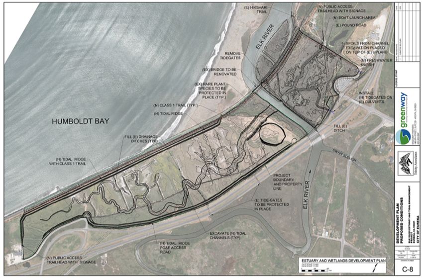
Draft Resolution No. R1-2021-0017          -2-                            March 23, 2021
Elk River Restoration

4. Historically, the Facility has discharged on the ebb tide to ensure that wastewater
   was conveyed to the Pacific Ocean. Regional Water Board Resolution No. 80-10
   concluded that the discharge to Humboldt Bay during ebb tide effectively classifies
   the discharge as an ocean discharge, rather than a discharge to an enclosed bay.
   On November 20, 1980, The State Water Board adopted Resolution No. 80-87
   approving the ebb tide discharge concept as consistent with the requirements of the
   Policy.

5. National Pollutant Discharge Elimination System (NPDES) Order No. R1-2009-0033
   required the Permittee to perform an effluent discharge study to assess the transport
   and fate of pollutants discharged from the Facility as well as the potential impacts to
   beneficial uses associated with the ebb-tide discharge. In compliance with Order No.
   R1-2009-0033, on January 8, 2014, the Permittee submitted the Effluent Discharge
   Study for the Elk River Wastewater Treatment Plant (2014 Effluent Discharge
   Study). The study utilized two models to simulate effluent transport:

   Advanced circulation (ADCIRC) as the primary model to predict currents within the
   Humboldt Bay that are the dominant mechanism of conveying effluent out to the
   ocean; and

   Particle tracking model (PTM) as a secondary model to track particles of effluent
   released by the Facility (utilizing currents predicted by ADCIRC).

   For baseline simulations, discharges began at slack tide and continued through the
   designated discharge window. Simulations were then conducted to determine the
   fate of effluent discharged under various tidal and Facility flow conditions. The 2014
   Effluent Discharge Study modeling analysis shows that under all simulations the
   effluent is never completely conveyed to the ocean, and under certain conditions up
   to 90% of the effluent remains in the Humboldt Bay.

   Thus, the findings of the original studies used to support Resolution No. 80-87 that
   concluded the Facility’s discharge was effectively an ocean discharge are
   contradicted by the 2014 Effluent Discharge Study results. Based on the
   conclusions of the 2014 Effluent Discharge Study, the discharge is not consistent
   with the findings of Resolutions 80-10 and 80-87 since a significant portion of the
   Facility’s effluent remains in the Humboldt Bay.

   Regional Water Board staff determined that the 2014 Effluent Discharge Study was
   representative of current conditions and more accurately describes the discharge as
   compared to the original studies. Consequently, the Regional Water Board
   determined that the discharge does not qualify as an ocean discharge subject to the
   Ocean Plan but rather a bay discharge subject to the Enclosed Bays and Estuaries
   Policy.
Draft Resolution No. R1-2021-0017          -3-                             March 23, 2021
Elk River Restoration

6. Cease and Desist Order No. R1-2016-0012 (CDO) was adopted by the North Coast
   Regional Water Board (Regional Water Board) on June 20, 2016. The CDO
   requires, in part, the Permittee to submit for Executive Officer review and approval a
   Feasibility Study that considers the Outfall Inspection Report, Updated Sewer Use
   Ordinance Evaluation Report, Climate Change Readiness Study Plan, and Biological
   Survey Report required in accordance with NPDES Order No. R1-2016-0001
   (NPDES Permit), and evaluates and recommends alternatives to achieve
   compliance with the Enclosed Bays and Estuaries Discharge Prohibition.

   The NPDES Permit includes Discharge Prohibition III.A that states, “The discharge
   of waste to Humboldt Bay is prohibited unless it complies with the State Water
   Board, Water Quality Control Policy for the Enclosed Bays and Estuaries of
   California (1974, 1995).” When the NPDES Permit is renewed, Prohibition III.A. will
   be retained.

7. Task 2B of the CDO requires the Permittee to, “submit written verification and an
   electronic copy of preliminary design plans and specifications for construction of the
   Executive Officer approved Preferred Alternative(s).” The project presented as an
   attachment to this Order is the first step in completing Task 2B of the CDO.

8. Regional Water Board staff and Permittee staff have meet regularly since adoption
   of the CDO and NPDES Permit to collaborate on a plan to chart the best path
   forward. On August 12, 2019, Regional Water Board Staff (Staff) sent a letter to the
   Permittee laying out staff’s interpretation of the Enclosed Bays and Estuaries Policy,
   summarizing the outcomes of various discussions between the Permittee and Staff,
   and outlining the criteria by which enhancement will be evaluated. The Permittee
   must meet the following minimum criteria to be considered of an exemption to the
   Enclosed Bays and Estuaries Policy:

8.1. Provide enhancement that would not occur in the absence of the discharge.

8.2. Create additional marshlands or wetlands or other enhancing features.

8.3. Provide full protection of beneficial uses which the receiving water is capable of in
     the absence of the discharge.

8.4. Demonstrate that the project will yield a positive water quality benefit.

8.5. Provide full secondary treatment, including disinfection and dechlorination to all
     discharge flows to Humboldt Bay.

8.6. Eliminate blending within the treatment facility.

8.7. Comply with applicable water quality objectives for ammonia.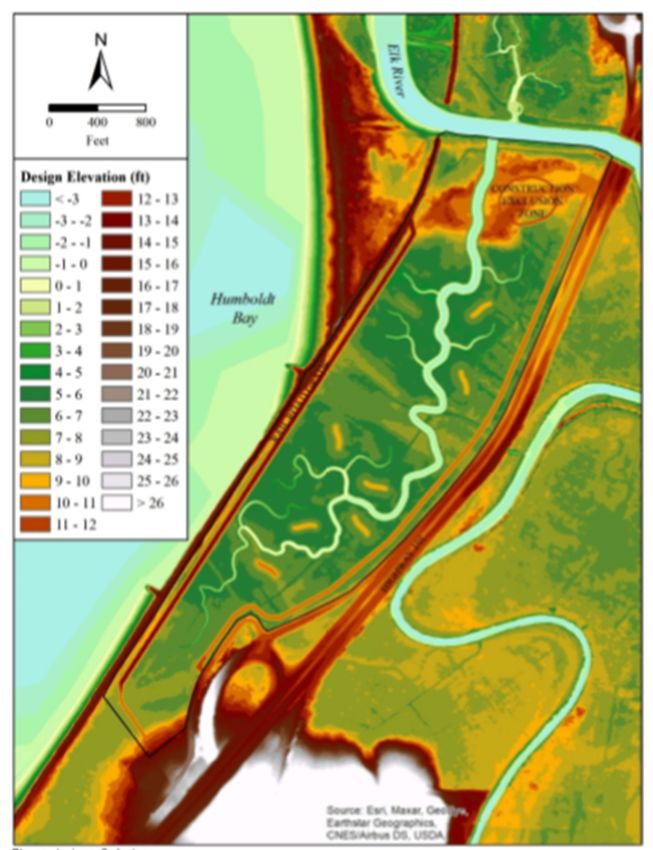
Draft Resolution No. R1-2021-0017         -4-                             March 23, 2021
Elk River Restoration

9. On September 26, 2019, the Permittee submitted a letter to Staff that indicated the
   Permittee’s interest in pursuing the Elk River Tidal Marsh Enhancement Project by
   providing a benefit that “enhances the quality of the receiving water above that
   which would occur in the absence of the discharge.” As its preferred project, the
   Permittee proposes to provide funding to implement the Elk River Tidal Marsh
   Enhancement Project (Project). The Project when implemented would meet criteria
   8.1, 8.2, 8.3 and 8.4. The Permittee is currently evaluating alternatives to comply
   with criteria 8.5, 8.6 and 8.7. Ammonia modeling is currently being performed to
   determine if a mixing zone is applicable. These criteria will be met through
   compliance with the new NPDES permit scheduled for adoption in Spring of 2022.
   The Project proposes to include:

9.1. Restoration and enhancement of 114 acres of estuarine and intertidal habitats on
     City-owned property on both sides of the Elk River and adjacent to the Elk River
     Wastewater Treatment Facility. Restoration and enhancement will include
     regrading to create low flow habitat areas, removal of invasive plant species,
     planting of native plants and grasses, and the removal of structural constraints
     such as tide gates to allow hydraulic conductivity. The Project includes two areas,
     referred to as Area 1 and Area 2. Attachment A includes the Permittee’s Project
     Proposal and details the restoration and enhancement for Area’s 1 and 2
     specifically.

     Area 1 is located North of the Elk River and South of the Facility. Area 1 is
     approximately 25 acres of degraded inter-tidal wetland that will be restored by
     removing the riverfront levee and tide gate infrastructure, and excavating slough
     channels, integrating salt marsh plains, and public access via extension of the
     City’s Waterfront Trail. A map of Area 1 can be found in the Permittee’s Project
     Proposal in Attachment A.

     Area 2 is approximately 89 acres located south of the Elk River. It is comprised of
     agricultural ditches, pasture, and degraded seasonal wetlands. The area is
     separated from the Elk River on the north side by a natural windblown sand
     formation, parallel to Elk River Slough. Construction of a rock seawall and the
     railroad infrastructure on the west side has isolated Area 2 from Humboldt Bay.
     Most of Area 2 is drained by a network of linear agricultural ditches and there is no
     freshwater inflow. Area 2 will be converted to an inter-tidal wetland with a network
     of tidal slough channels. The channel area will be contained by tidal ridges (living
     shorelines) that will host riparian habitat as well as public access trails.

9.2. Creation of public access via land and water through the development of a 0.2-
     mile Coastal Access Trail on the western edge and a kayak launch on the northern
     side of Area 1.

9.3. Creation of an interpretive center that could support increased public access and
     provide information on protection and restoration of Humboldt Bay, information
     about native and restored habitats, and information about local aquatic and wildlife
     species.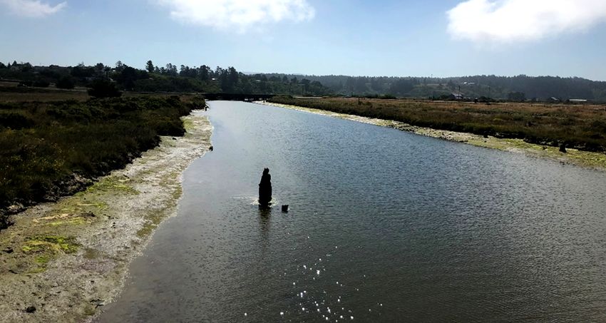
Draft Resolution No. R1-2021-0017             -5-                              March 23, 2021
Elk River Restoration

9.4. Removal of the existing tide gates, excavation of tidal channels to increase the
     tidal prism and eelgrass habitat, removal of invasive Spartina, and enhancement
     of native salt and freshwater marsh and riparian habitat through active and
     passive revegetation.

9.5. Funding up to $3.3 million toward completion of project construction.

10. On November 2, 2020, Staff responded to the Permittee’s project proposal with a
    Staff level concurrence letter (Letter). The Letter acknowledges that the proposed
    project is, “is in satisfactory compliance with the exception eligibility criteria for water
    quality enhancement projects set forth in Staff’s August 12, 2019 letter to the
    Permittee” discussed in Finding 6 above. The project meets the criteria listed in 8.1
    through 8.4 under item 8 identified above.

11. An additional requirement stipulated in the Letter is that the Permittee develop and
    implement a long-term plan to identify and address critical infrastructure and
    significant pollutant sources that are currently impacting Humboldt Bay, or at risk of
    impacting due to sea level rise. The Permittee shall develop this plan in coordination
    with and taking into consideration the input and advice from key stakeholder and
    partner agencies, such as the Coastal Commission, City of Arcata, the Harbor
    District, and environmental groups who will form part of a Technical Advisory
    Committee (TAC). The Permittee shall be required to conduct the following as it
    relates to the TAC:

11.1. Develop a Governance Structure/Memorandum of Understanding in coordination
      with the Regional Water Board for the oversight and management of the TAC and
      development of deliverables.

11.2. Hold and host regular meetings to make progress on the objective(s) of the
      project.

11.3. Develop and submit annual progress reports

11.4. Prepare assessment reports and maps of Permittee owned and operated critical
      infrastructure and significant pollutants sources.

11.5. Develop an Action Plan for all City owned, operated, or maintained sources,
      facilities, or infrastructure.

   To comply with the California Environmental Quality Act (CEQA, Pub. Res. Code §
   21000 et seq), the potential environmental effects associated with the project were
   analyzed in the Initial Study/Mitigated Negative Declaration (SCH#2017082048)
   prepared by the City of Eureka, the lead agency for the project. The Regional Water
   Board, as a responsible agency under CEQA, has reviewed and considered the
   environmental documentation prepared by the City of Eureka for those aspects of
   the project that are within the Regional Water Board’s jurisdiction.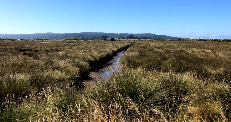
Draft Resolution No. R1-2021-0017           -6-                             March 23, 2021
Elk River Restoration

   The Regional Water Board finds that none of the conditions described in California
   Code of Regulations, title 14, section 15162 have occurred such that preparation of
   additional environmental documents pursuant to CEQA is required.

                                      RESOLUTION

   THEREFORE it is hereby resolved that:

   The Regional Water Board determines the Elk River Tidal Enhancement Project
   (Project), attached hereto as Attachment 1 as set forth in the above Resolution, is
   consistent with the exception to the Enclosed Bays and Estuaries Discharge
   Prohibition, and is available to the City of Eureka as a method for complying with
   Discharge Prohibition III.A. in NPDES permit Order No. R1-2016-0001.

                                     CERTIFICATION

   I, Matthias St. John, Executive Officer, do hereby certify that the foregoing is a full,
   true, and correct copy of a Resolution adopted by the California Regional Water
   Quality Control Board, North Coast Region, on June 17, 2021.

   ________________________________

   Matthias St. John

   Executive Officer

   21_0017_Eureka_Elk_River_Restoration Draft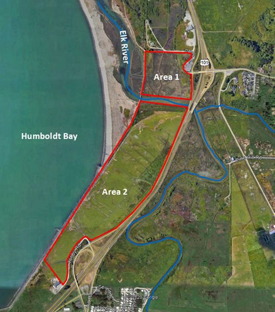
Draft Resolution No. R1-2021-0017 -7- March 23, 2021
Elk River Restoration
ATTACHMENT A - ELK RIVER ESTUARY TIDAL ENHANCEMENT PROJECT
PROPOSAL
1. Introduction
The North Coast Regional Water Quality Control Board (Regional Water Board) has
indicated that the City of Eureka may continue to pursue effluent discharge from the
Elk River Wastewater Treatment Plant (ERWWTP) to the entrance of Humboldt Bay
under an exception to the Enclosed Bays and Estuaries Policy (EBEP). The EBEP
requires “A demonstration by the applicant that the discharge, through the creation
of new beneficial area or a fuller realization, enhances water quality for those
beneficial uses which could be made of the receiving water in the absence of all
point source discharges.” The definition of enhancement was further defined by the
Regional Board in a letter dated August 12, 2019, which includes minimum
performance criteria, project evaluation metrics, and other considerations.
The City of Eureka is proposing to develop and construct the Elk River Estuary Tidal
Enhancement Project (the Project) to meet the enhancement requirements of the
EBEP. The Project addresses minimum performance criteria, and also rates highly
in the project metrics, including longevity, climate resilience, and water quality
improvement, among other metrics.
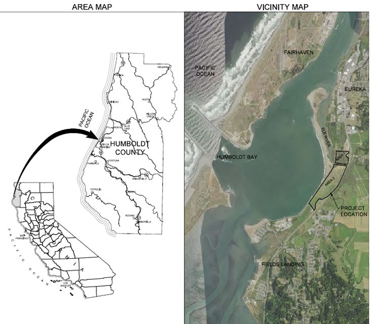
The Elk River is the largest and most ecologically significant river entering Humboldt
Bay. Ecological values of the Elk River include Old Growth Redwoods, Marbled
Murrelet, Bald Eagle, Coho and Chinook Salmon, and Steelhead, all of which utilize
estuarine habitat for rearing and foraging. This watershed is heavily impacted by
upstream land use including grazing, farming, and timber harvesting, which have
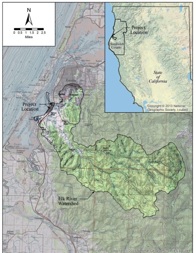
significantly impacted water quality, hydrology, and sediment transport. Figure 3 is
included showing the scale of Elk River Watershed. Structures such as roadways,
dikes and tide gates restrict natural hydrology and sediment accretion, create
barriers to fish passage, and degrade wildlife habitat. The City of Eureka seeks to
improve these issues through the development of the Elk River Tidal Enhancement
Project.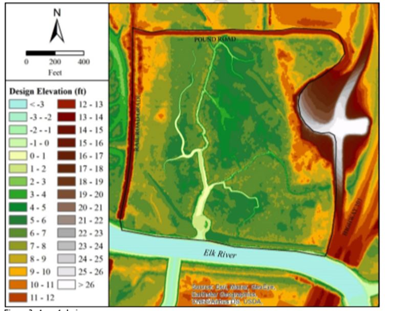
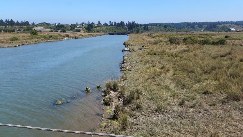
Draft Resolution No. R1-2021-0017          -8-                            March 23, 2021
Elk River Restoration

Figure 1: South Bank of the Elk River Looking East from Existing Bridge

2. Project Summary

   The Project will restore and enhance estuary and inter-tidal wetland habitats on
   approximately 114 acres adjacent to Elk River, create approximately 2.8 miles of
   navigable tidal slough channels connecting to the Elk River Estuary, as well as
   provide public access amenities to Elk River and Humboldt Bay with a one mile
   extension of Class 1 ADA-compliant Waterfront Trail , the construction of a non-
   motorized boat access point, a trailhead parking area off Tooby Road and, in a later
   phase, an Elk River Interpretive Center.

   The Project area currently consists of pasture, coastal scrub, degraded seasonal
   wetlands dominated by pasture grasses, and salt marsh dominated by invasive
   Spartina (Spartina densiflora), lacking key ecosystem processes such as tidal
   exchange. The Project will restore a functioning tidal marsh complex with native
   vegetation and a network of tidal channels to allow for full tidal exchange with Elk
   River Slough. This will require the conversion of some degraded seasonal
   freshwater and brackish wetlands, currently used for livestock grazing, to inter-tidal
   wetlands (salt marsh) and tidal channels (open water, Eelgrass habitat,
   and mud flat).
Draft Resolution No. R1-2021-0017       -9-                          March 23, 2021
Elk River Restoration

Figure 2: Proposed Site Plan of the Elk River Tidal Enhancement Project

2.1. Location

     The Project is bound by U.S. Highway 101 and Humboldt County’s Tooby Road
     on the east and the North Coast Railroad Authority (NCRA) right of way on the
     west. The City’s Waterfront Trail, wastewater treatment facility, and private
     properties border the project on the north. The southern project boundary is
     bordered by private property. The entire site is owned by the City of Eureka.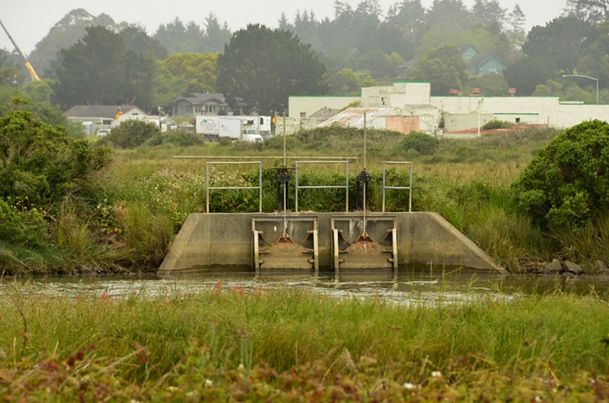
Draft Resolution No. R1-2021-0017    - 10 -   March 23, 2021
Elk River Restoration

Figure 3: Map of the Elk River Watershed
Draft Resolution No. R1-2021-0017         - 11 -                           March 23, 2021
Elk River Restoration

2.2. Estuary Function

     The Elk River Estuary provides a critical opportunity to rebuild a portion of the lost
     tidal marsh systems around Humboldt Bay. Between the years 1870 and 1910,
     Humboldt Bay lost an estimated 90% of its salt marsh and wetland habitat due to
     diking and draining for agricultural and railroad purposes (Shapiro and Associates,
     1980). The estuary is currently very limited in area and habitat diversity. It has
     generally become a three-mile long, linear, diked slough channel with very few
     tidal marsh areas.

     Healthy tidal marsh systems provide invaluable nutrients within an estuary
     ecosystem. An estuary is an enclosed body of brackish water formed by part
     saline water from ocean tides, along with freshwater flows from steams or rivers.
     The combination of seawater and freshwater produce high level of nutrients in the
     water column. A tidal marsh is a unique feature within an estuary where the area
     floods and drains based upon the tidal influence. The proposed project will create
     a functioning tidal marsh system across more than 100 acres to provide these
     unique habitat and water quality benefits.

2.3. Exception Criteria

     The project was specifically selected as it poses the ability to restore these coastal
     landscape processes to both former tidelands and historic floodplain, and fulfill the
     minimum exception criteria identified by the Regional Water Board (exception
     criteria). Project outcomes include restoring lost hydrologic function, establishing
     estuary habitat, creating habitat for special status species, improving water quality,
     and providing public access. Four of the exception criteria are addressed with the
     Project, and described in greater detail in this document. Those are:

        ·   Provide enhancement that would not occur in the absence of the discharge.

        ·   Create additional marshlands or wetlands or other enhancing features.

        ·   Provide full protection of beneficial uses which the receiving water is
            capable of in the absence of the discharge.

        ·   Demonstrate that the project will yield a positive water quality benefit.

     The project has been evaluated based upon a series of metrics (evaluation
     metrics). These include:

        ·   Longevity of Enhancement: The components of the Project are enduring
            and provide intended benefits for a minimum time frame equivalent to the
            infrastructure life of 30 years.

        ·   Adaptive Capacity/ Natural Resilience: The project has the ability to adapt
            to changing conditions in the natural environment over time, as well as the
Draft Resolution No. R1-2021-0017 - 12 - March 23, 2021
Elk River Restoration
opportunity to restore and enhance habitat by planting native plants and
improving biological diversity.
· Climate Change Resilience: The project has the ability to continue to
provide benefits to address climate change over time for at minimum the life
of the infrastructure.
· Consistent with Regional Planning Efforts: The project supports existing
regional planning efforts to support Humboldt Bay.
· City Amenability to Long-Term Maintenance: The project components can
be maintained for their useful life and the City can address long term
maintenance costs and responsibilities.
3. Summary of Proposed Actions
The Project site is organized as Area 1 to the north of Elk River and Area 2 to the
south of Elk River. Area 1 is approximately 25 acres of degraded inter-tidal wetland
that will be restored by removing the riverfront levee and tide gate infrastructure, and
excavating slough channels, integrating salt marsh plains, and public access via
extension of the City’s Waterfront Trail. A simplified list of the proposed actions and
sequence for Area 1:
· Re-contour the entire site and expand existing channel: Excavate and
enlarge (widen and deepen) inter-tidal channels. Excavate approximately
3,385 ft of existing and 2,394 ft of new inter-tidal channels and excavate and
intersperse tidal ponds or depressions in channels.
· Repurpose the excavated soil material to create sloped channel edges and
marsh plains. Fill artificial depressions and levee borrow ditches, and create
tidal mounds/hummocks (islands). Provide cover for wildlife and create
habitat diversity by placing wood debris on site.
· Remove non-native vegetation, specifically eradicate 20 acres of invasive
Spartina, and revegetate the site over multiple years.
· Excavate and remove interior, exterior dikes and Elk River tide gates allowing
river currents and tidal slough currents to travel into the project Area.
· Construct public access amenities: Install non-motorized boat access near
the terminus of Pound Road. Extend the Waterfront Trail 1,000 feet from its
existing terminus at Pound Road, southward parallel to the railroad grade to
Elk River. Design and construct the future Interpretive Center facility north of
Pound Road.Draft Resolution No. R1-2021-0017 - 13 - March 23, 2021 Elk River Restoration Figure 4: Elk River Estuary Tidal Enhancement Project, Areas 1 and 2 Figure 5: Looking West at High Tide in Area 1 at Spartina Dominated Salt Marsh. Area 2 is approximately 89 acres located south of the Elk River. It is comprised of agricultural ditches, pasture, and degraded seasonal wetlands. The area is separated from the Elk River on the north side by a natural windblown sand formation, parallel to Elk River Slough. Construction of a rock seawall and the railroad infrastructure on the west side has isolated Area 2 from Humboldt Bay.
Draft Resolution No. R1-2021-0017         - 14 -                          March 23, 2021
Elk River Restoration

   Most of Area 2 is drained by a network of linear agricultural ditches and there is no
   freshwater inflow. Area 2 will be converted to an inter-tidal wetland with a network of
   tidal slough channels. The channel area will be contained by tidal ridges (living
   shorelines) that will host riparian habitat as well as public access trails.

   Generalized list of proposed actions and sequence for Area 2:

      ·   Re-contour the area by excavating approximately 125,200 cubic yards to
          create a network of new inter-tidal channels. Use excavated material to fill
          agricultural ditches, and construct the design features such as sloped tidal
          ridge(s), marsh plains, and create depressions and mounds (tidal islands).

      ·   Remove invasive vegetation, including Spartina, and install a variety of native
          vegetation types and create habitat features by placing woody debris.

      ·   Construct public access amenities including new gravel parking area at the
          southern end of Tooby Road, and the Waterfront Trail Extension trail from the
          new parking lot northward to the Elk River.

Figure 6: Area 2 Existing Pastureland

3.1. Reclaim Historic Tidelands and Restore Elk River Floodplain

     The lower portion of the Elk River watershed, has been impacted by urban
     development and human activities that encroach upon the floodplains and have
     affected the distribution and timing of drainage during rainfall and storm events.
Draft Resolution No. R1-2021-0017 - 15 - March 23, 2021
Elk River Restoration
The lower Elk River drains through fragmented floodplains, diked from floodplain
overflow which means that the rain fall, and storm water is restricted and
constrained between the dikes, roadways, culverts, pasture, degraded marsh, and
man-made levees. Highway 101 bisects the Elk River floodplains controlling the
drainage along its length. During extreme storm events the highway acts as a
weir with water traveling through under-sized culverts and remaining water sheet-
flowing across paved surfaces, pasture, and surrounding areas. Water on the
east side of Highway 101 becomes trapped in upslope drainage ponds and
contributes to localized flooding.
The Project area contains historical tidal wetlands that were diked off from the Elk
River for agricultural and railroad purposes in the early 1900’s. The Project site is
situated between the railroad levee to the west and Highway 101 infrastructure to
the east. These man-made structures trap storm water from draining.
Additionally, the dikes, levees, and resulting sand deposits create a barrier to tidal
activity within the project. As part of an effort to not increase flood levels on
adjacent properties and critical infrastructure (Highway 101) this Project has gone
through an iterative design process with design alteration based on hydraulic
analysis. This led to the proposed project design that not only avoids increasing
flood levels, it reduces them.
The Project will remove the riverfront dikes along the Elk River frontage to allow
high-flowing turbid stormwater in the river channel to enter a newly constructed
tidal channel flowing into and onto marsh plain surfaces. Stormwater will flow from
the Elk River into project wetlands that serve as tidal marshes and stormwater
flood basins. The proposed design allows for drainage into the Elk River though
the newly constructed tidal channel mouth when river levels recede downstream
as tides drop and when upstream floodwaters cease.
Not only will the Project result in a reduction of flooding for various adjacent areas,
it will also reduce flooding in distant areas. During a large storm event, river flows
will move down river, enter the Project site, and then be captured and detained
within the Project. When the river levels then recede or the tide levels recede
through a natural tidal cycle, water will naturally exit the Project area through the
mouth of the channel and back into Elk River Estuary.Draft Resolution No. R1-2021-0017 - 16 - March 23, 2021
Elk River Restoration
Figure 7:In Area 2 the Existing Degraded Pasture
The project team has analyzed the extreme (estimated 100-year recurrence
interval) coastal and fluvial events in the Lower Elk River. The project has been
designed to either pose no adverse impacts, or to lower adverse impacts to
infrastructure such as Highway 101 and adjacent properties.
The design of elements to restore the floodplain directly addresses the exception
criteria and evaluation metrics. As climate change causes larger and more
extreme storm events, the new Project areas will provide capacity for stormwater,
reduce localized flooding to adjacent properties, as well as reduce flooding
upstream. As noted above, current stormwater often travels across paved
surfaces, through man-made culverts and other infrastructure, carrying pollutants
directly into the Elk River and Humboldt Bay. The Project provides a new
mechanism to direct stormwater into a natural biologic system to filter pollutants
and sediments before water is returned to the Elk River Slough, thereby improving
water quality in Humboldt Bay.
Similarly, the Project will restore historic tidelands and provide an enhancement
that is adaptive to Sea Level Rise (SLR). The hydrological design will provide
longevity of the enhancement for a minimum of 30 years, is adaptable to SLR, is
consistent with regional planning efforts toward SLR, and will ensure that the City
can maintain the enhancement for its’ useful life of 30 years.
Without these improvements to the historic tideland and floodplain, the storm flows
and high tide events will continue to carry pollutants into Humboldt Bay. Without
the Project, the beneficial uses of Humboldt Bay as well as water quality benefits
cannot be achieved.Draft Resolution No. R1-2021-0017 - 17 - March 23, 2021
Elk River Restoration
This demonstrates that the enhancement Project will create benefits that would
not be present in the absence of the discharge, and the Project is a creation of
unique benefits and enhancement to the receiving waters of Humboldt Bay. By
approving the Project as an exception to the discharge permit, the Regional Water
Board plays a role in protecting protect beneficial uses and yielding significant
water quality improvements.
3.2. Create Tidal Marsh Systems and Improve Water Quality
Use of design features: Channels, Marsh Plains, Tidal Ridge
While an estuary may be viewed as one large flat space when filled with water, it
should be viewed as a unique set of elevations that are under water. Each
elevation has a function to perform within the wetland system. The project design
features result in various elevations including deep channels, shallow channels,
sloped edges, marsh plains, wetland depressions and hummocks, riparian upland
areas, as well as higher sloped tidal ridges. These features integrated across the
114 acre site provide a vast system to perform water quality enhancement through
settling of solids and sediments, filtration of pollutants in the water column, and
chemical detoxification by adding oxygen and biologic elements into the water
through wetland vegetation.
The restoration components of the Project include re-connecting the historic
floodplain property to the lower Elk River. The Lower Elk River is listed as an
impaired water body under Section 303(d) of the Clean Water Act due to the
sedimentation and siltation as well as indicator bacteria. By connecting the river’s
lower floodplains through a series of new tidal channels the fine sediments will be
metered and stored. The proposed network of tidal slough channels will capture
and receive the twice-daily tidal cycle as well as receive stormwater making the
entire project perform as a tidal marsh system with deep channels, low wet-lands,
and upper marsh plains. Vegetating the marsh plains with native tidal, brackish,
and freshwater marsh plant species will filter and trap sediment on the marsh
plains, while improving the richness of the habitat and building soils. By reducing
the accumulation of fine sediments within the water column, and providing for
natural sediment deposits along marsh plains, the project will improve water
quality.Draft Resolution No. R1-2021-0017 - 18 - March 23, 2021
Elk River Restoration
Figure 8: Site Images Showing Existing Channel North of the Elk River in 25
Acres of Area 1, and Existing Pasture South of Elk River in 89 acres of Area 2.
Proposed Channel Network in Blue and Tidal Ridge in Yellow.
The proposed tidal slough channel shape and geometry is designed to transport a
full tidal regime into the restoration areas, during each tide cycle. The proposed
marsh plains are designed at target elevations to accommodate existing high-tide
events as well as predicted sea level rise to promote a natural colonization of
native salt marsh species and sedimentation to enhance water quality. As a
result, rising tide levels will naturally deposit native seed material as well as
sediment onto the marsh plains and thereby establish grasses and native plant
species so the site can evolve and perform related water quality enhancement that
is enduring and longstanding after the project.
The Project will create a tidal ridge on the west, south, and east edge of the
project to establish a high-point around the lower channel and marsh systems. A
tidal ridge is often called a living shoreline, and includes constructing a gradually
sloping berm with vegetation along its slopes. Living shorelines often have water
travel through a berm or levee structure creating water filtration. While the
proposed tidal ridge is permeable and provides some filtration, the design is
intended to hold water within the project and support the hydrologic connection
between the River and the project features. For the purpose of this project a tidal
ridge is defined as a berm rising from the intertidal zone to an elevation above the
tidal zone. This elongated linear berm feature will provide immense water quality
benefits due to the exchange of water with tides and storm events.Draft Resolution No. R1-2021-0017 - 19 - March 23, 2021
Elk River Restoration
The gradual slope design allows the project to establish native vegetation at the
site, and the tidal influence will carry sediment to the tidal ridge. When sediment is
deposited this is called sediment accretion. This helps the biologic diversity at the
site and encourages native plant establishment.
Wetlands function as natural water cleansing systems by spreading low velocity,
shallow water through densely vegetated surfaces filtering pollution from the water
column. Stormwater and tidal water will drain into and from the project site
through tidal channel networks and flow into connected side-channels and marsh
systems. During storm events the channel network will provide detention area and
hold water until storm flows and tide levels recede. This constant movement of
water in-and-out of the channel network, reaching across the site, provides an
expansive marsh filtration system with tremendous enhancement to water quality.
As water enters the site, caring pollutants and bacteria in the water column, the
water will spread through the channels and across the marsh plains, filtering
pollutants, and depositing sediments, before the tides pull water back through the
site returning to the Elk River and into Humboldt Bay.
The noted Project design features along with the hydrologic modeling and use of
varied elevations create a true enhancement project to meet the exception criteria.
Similarly, the Project features explicitly create marshlands, wetlands, and other
enhancing features. The tidal channels provide open waters, and navigational
waters, for both human uses and aquatic species providing beneficial uses noted
for Humboldt Bay. (Beneficial uses are explored further and later in this
document). The design elements will self-perform and adapt over time, as well as
provide climate resilience and adaptation to Sea Level Rise providing longevity.Draft Resolution No. R1-2021-0017 - 20 - March 23, 2021 Elk River Restoration Figure 9: Area 1 Proposed Elevations Based Upon Hydrologic Modeling.
Draft Resolution No. R1-2021-0017       - 21 -                         March 23, 2021
Elk River Restoration

Figure 10: Area 2 Proposed Elevations Based Upon Hydrologic Modeling.

3.3. Establish Habitat

     Tidal marshes filter out pollutants; buffer adjacent lands from flood tides and
     storms; contribute invaluable nutrients to the estuarine ecosystem; and provide
     important habitat for fish, invertebrates, many shorebirds, and other waterfowl.
     The project will establish habitat over 114 acres with the development of salt
     marsh, freshwater wetlands, brackish marsh, open waters, riparian areas, and
     upland areas. The Project will provide much needed habitat types for a variety of
     endangered, threatened, and special status species along with migratory birds.
Draft Resolution No. R1-2021-0017 - 22 - March 23, 2021
Elk River Restoration
· By removing dikes and tides gates the Project will create new fish habitat
and fish refuge to support listed salmonid species including Chinook
Salmon (Oncorhynchus tshawytscha), Coho Salmon (Oncorhynchus
kisutch), and Steelhead Trout (Oncorhynchus mykiss).
· The new channel network and marsh plains will increase inter-tidal,
brackish, and freshwater habitats for important aquatic species including
but not limited to Eelgrass, Olympia Oyster (Ostrea lurida), Dungeness
Crab (Metacarcinus magister), Longfin Smelt (Spirinus thaleichthys),
Tidewater Goby (Eucyclogbius newberryi), Humboldt Bay owl’s clover
(Castilleja ambigua ssp. humboldtiensis), Lyngbye’s sedge (Carex
lyngbyei), and Point Reyes bird’s-beak (Chloropyron maritimum ssp.
palustre).
· Removal of invasive dense-flowered cordgrass (Spartina densiflora)
vegetation from the site, and creation of healthy salt marsh with a range of
surface elevations to support low and high salt marsh vegetation, including
protection and re-introduction of special status plant species Lyngbye’s
sedge and Humboldt Bay Owl’s Clover.
· By re-establishing riparian and upland habitat with native vegetation, this
will provide needed shelter and vegetation for resident and migratory bird
species.
Table 1: Existing and Projected Acreages of Habitats, Agricultural lands, Roads
and Trails Area 1 and 2 Combined.
Land Type Existing Proposed Net Change
Acreage1 Acreage in Acreage
Eelgrass (on mudflats within tidal 0 6.0 + 6.0
channels)
Open Waters 1.2 3.0 + 1.8
Brackish Marsh 1 1.3 0 -1.3
Agricultural Wetlands (Pastureland) 68.9 0 - 68.9
Agricultural Uplands (Pastureland) 13.8 0 - 13.8
Freshwater (Vegetated Drainage 0.7 0 - 0.7
Ditches)
Freshwater Marsh 0 0.7 + 0.7
Salt Marsh 20.8 77.8 + 57
Riparian 0.2 11.3 + 11.1
Uplands 5.8 0 - 5.8
Road/Trail 1.2 9.3 + 8.1
1
All acreages are approximateDraft Resolution No. R1-2021-0017 - 23 - March 23, 2021
Elk River Restoration
The Project will provide necessary habitat types for a variety of species, which
touches on the integration of the Project to address regional planning efforts. The
Project design functions to support fish habitat are consistent with the goals of the
California Department of Fish and Game Recovery Strategy for California Coho
Salmon, as well as the US Fish and Wildlife Service Recovery Plan for the
Tidewater Goby.
While the rearing habitat and refuge in the estuary is currently scarce, Coho and
other anadromous fish are still spawning in the upper reaches of Elk River. With
climate change, the lower reaches of the river could warm and become too
shallow to support fish during the drier months. Similar barrier removal projects
have been completed in other estuaries on Humboldt Bay and report success in
providing critical rearing habitat and estuarine refuge.
Figure 11:One of the Main Restoration Components in Area 1 is the Removal of
Existing Tides Gates to Allow Tidal Inundation of the New Channel System.
Removal of Barriers Such as this Will Increase Habitat for Fish and Aquatic
Species
Restoration of vegetation types at the Project includes the removal of more than
20 acres of dense-flowered cordgrass (Spartina densiflora). Spartina can grow
year-round in varied salt-marsh environments and naturally out-competes the
native vegetation which will generally go dormant in the winter. Spartina is so
invasive it can actually reshape the landscape by the physical structure, large
stem, and root density, and impacts to sediment retention.Draft Resolution No. R1-2021-0017 - 24 - March 23, 2021
Elk River Restoration
The Project will remove Spartina over multiple years, to encourage native
vegetation. These efforts are consistent with the Humboldt Bay Regional Spartina
Eradication Plan.
Existing plants species documented at the project site, and listed as threatened or
endangered include Lyngbye’s Sedge and Humboldt Bay Owl’s Clover. Both of
these plants will be protected as they exist in small quantities, and re-introduced
throughout the project site. The US Fish and Wildlife Service facilitates a
monitoring program for the Owl’s Clover at the Humboldt Bay Wildlife Refuge.
Establishment of tidal marsh vegetation along with the tidal marsh plains will
provide direct benefits to many resident and migratory bird species. Humboldt
Bay is located within the Pacific Flyway, which is the north-south travel route for
migratory birds extending from Alaska to Patagonia. The Project will provide a
location to rest and forage. Numerous species utilize coastal landscapes and
marsh plains including small species; swallow, wrens, and sparrows, as well as
waterfowl; ducks and geese. Larger bird families are also present including heron,
egret and even raptors, like red-tailed and red-shouldered hawks. But the bay is
most famous for the vast species of shorebirds such as plovers, sandpipers, and
godwits. The number of shorebirds utilizing the bay and surrounding seasonally
wet pasture and wetlands are higher than any other bay or estuary in California,
except San Francisco Bay. Eighteen State-listed bird species (“endangered” of
“species of concern”) utilize similar habitats along Humboldt Bay.
The exception criteria stress that the Project must provide full protection of
beneficial uses which the receiving water is capable of in the absence of the
discharge. The Project has been analyzed against the beneficial uses attributed
to Humboldt Bay in the North Coast Region Basin Plan. The creation of habitat
touches on a minimum of six of the beneficial uses; Estuarine Habitat, Marine
Habitat, Wildlife Habitat, Preservation of Rare, Threatened or Endangered
Species, Migration of Aquatic Organisms, and Spawning, Reproduction, and Early
Development.
Many of the noted endangered, threatened, and concern-status species are
vulnerable to the impacts of climate change. The project provides climate
adaptation and resilience for wildlife in the form of habitat connectivity,
improvement of habitat quality for climate vulnerable species, sea level rise
adaptability, and invasive species removal. The project will decrease the climate
change vulnerability of ecosystems and species important to Humboldt Bay by
providing marsh habitat types and their related benefits.
Incorporating passive public use with trails, non-motorized boat launch, signage
and the future Elk River Interpretive Center also creates a method to reach and
teach the public about the importance of habitat. The public access amenities
provide a way to engage with the surroundings and develop an appreciation and
respect for these impressive habitat systems.Draft Resolution No. R1-2021-0017 - 25 - March 23, 2021
Elk River Restoration
The trails and site features are designed to encourage passive use, while also
creating a wide buffer to protect vegetation and waterways from being trampled or
negative impacts of human uses.
3.4. Provide Public Access Amenities
Design Features: trail, parking, boat launch, future Interpretive Center
The Project includes an approximately one-mile-long Class I, ADA-accessible,
non-motorized multiuse trail along Humboldt Bay that will serve as part of the
California Coastal Trail. As designed to meet Caltrans Class I multi-use trail
design standards (Caltrans Highway Design Manual, Chapter 1000) and
Americans with Disabilities Act (ADA) design standards, the proposed trail will
expand shoreline access for a variety of users including bicyclists, walkers, hikers,
runners, skaters, wildlife viewers, nature educators, persons in wheelchairs, and
other non-motorized outdoor users. The trail will promote access to the Bay, the
Elk River estuary, and surrounding marshlands for wildlife viewing and recreation.
As part of the California Coastal Trail, it will attract users regionally and state-wide.
The one mile-long trail extension, which terminates at the southern boundary of
Eureka, will essentially complete the California Coastal Trail through the length of
the City’s waterfront, approximately six miles of which the City has constructed
over the past seven years. In addition, the City’s trail system is being developed
as part of a collaborative regional trail effort with the County of Humboldt, the City
of Arcata, the Humboldt County Association of Governments, the State Coastal
Conservancy, the North Coast Railroad Authority, and other partners to develop a
continuous coastal trail network along the eastern shoreline of Humboldt Bay for a
total length of over 13 miles.
Not only does the trail provide an access point to nature and a larger trail network,
it has been designed as a regional transportation facility. This has multiple
benefits for health and wellness, reduction of emissions by encouraging bike and
walk options, as well as improved safety for bike and pedestrians. The south trail
entrance at Tooby Road provides a critical access point for bike and pedestrian
travel approaching Eureka from the south, specifically from the isolated residential
area of Humboldt Hill. There are no sidewalks, access trails, or other non-
motorized facilities available between Humboldt Hill and Eureka City limits. As a
result, bikes and pedestrians utilize the narrow shoulder of Highway 101,
increasing conflicts between vehicles and non-motorized vehicles and resulting in
fatalities. The trail will provide an off-highway alternative for users traveling
between Humboldt Hill and Eureka proper.
The City will provide a coastal access parking area in an existing upland adjacent
to Tooby Road at the south end of the Project. The parking area will be graveled
and will support approximately 10 vehicles. In addition, parking at the north end of
Area 1 is available along Pound Road.Draft Resolution No. R1-2021-0017 - 26 - March 23, 2021
Elk River Restoration
Preliminary signage concepts include installing access welcome signs at Pound
Road (north end) and Tooby Road (south end).
The new non-motorized boat launch will be installed on the north side of the
project, with access from Pound Road where an existing park and ride parking lot
provides parking. This boating amenity will offer the ideal setting for a kayak,
canoe, or stand-up paddle board, to access the new channel network on the north
side of Elk River. At high-tide users can paddle through the channel and continue
upriver into the Elk River watershed, or down river into the Elk River Slough, and
then into Humboldt Bay.
Adjacent to the location of the new boat-launch, the City has identified a property
for the future Elk River Interpretive Center. The planning for this facility is still in
the early stages, but the current property owner is interested in selling to the City.
The parcel is approximately three acres and is positioned between the Project and
the City’s Elk River Wastewater Treatment Plant. The property will accommodate
the future Interpretive Center facility to include a building with gathering areas both
interior and exterior, restrooms, and interpretive displays. Adjacent to the
Interpretive Center, the Project may be further expanded to provide for nature
viewing opportunities on trails in and adjacent to the Center and the neighboring
Elk River Wastewater Treatment Plant.
The amenities provide for protection of beneficial uses of Humboldt Bay including:
· Improvements to navigation with new non-motorized boat launch and a new
expanded navigable channel extending 2.8 miles;
· Improvement in water contact recreation, for boating, paddling, and fishing;
· Improvement in water quality related to non-contact water recreation for
activities such as nature viewing and bird watching, with the project
attracting resident and migratory bird species; and
· Improvements in the recreational and sport fishery by helping to enhance
fish health and diversity of species.Draft Resolution No. R1-2021-0017 - 27 - March 23, 2021 Elk River Restoration Figure 12:Existing Waterfront Trail Connection on Pound Road Looking West Near Boat Launch Location Figure 13:Existing Waterfront Trail Along Pound Road, Looking South at Boat Launch Location
Draft Resolution No. R1-2021-0017         - 28 -                           March 23, 2021
Elk River Restoration

Figure 14:Looking South from Proposed Boat Launch Location at Low Tide.
Viewing the Existing Slough Channel in Area 1 that will be Widened and
Deepened Through the Enhancement Project.

3.5. Project Longevity

     The project will be self-sustaining over the long-term and adaptable to Sea Level
     Rise (SLR). The fully functioning tidal marsh complex includes various channel
     depths, variable marsh plains, wetland depressions, upland riparian areas, and
     sloped tidal ridges. The high projections for sea level rise on Humboldt Bay are:
     2030 at 0.9 feet, 2050 at 1.9 feet, 2070 at 3.2 feet, and 2100 at 5.4 feet. The
     design of the salt marsh plains range in elevation from 5.8 to 8.8. Mean high
     water (MHW) currently is 5.8 feet NAVD 88 as measured at the North Spit tide
     gage. By 2050, MHW may be as high as 7.7 feet and by 2070 at 9.0 feet. With
     increasing high tides, the project elevations will shift over time. The gradually
     sloping marsh plains and tidal ridges will allow wetlands to migrate upslope and
     remain viable for a longer period. Using an average accretion rate of 2.5mm/year
     and a projected rate of sea level rise, along with the project design, it is estimated
     the tidal marsh will be supported through at least 2050, with the upland riparian
     areas and tidal ridges are expected to support marsh habitat long past 2100 since
     they will be construction at elevations ranging from 9 to 12 feet. Habitat
     distribution for eelgrass and mudflat will also expand through 2100.

     The new trail extension and similar public access amenities will become part of the
     City’s larger trail network and will be scheduled for routine maintenance and
     upgrades as the system ages. Similarly, parking areas, the non-motorized boat
     access point, and signage or other amenities within the Project will be part of a
     scheduled assessment for upgrades or replacement as they age through the City’s
     Capital Improvement Program (CIP). The City will be actively managing and
     maintaining this facility to provide for long-term planning and upgrades as
     necessary.
Draft Resolution No. R1-2021-0017 - 29 - March 23, 2021
Elk River Restoration
Per the evaluation metrics, the Project will be enduring and provide intended
benefits for a minimum time frame equivalent to the infrastructure life of 30 years.
The design will adapt to changing conditions in the natural environment over time.
The project will continue to provide benefits that address climate change over
time. The project components can be maintained for their useful life and the City
can address long term maintenance costs and responsibilities.
4. Water Quality Benefit from Enhancement Project
The City of Eureka has worked closely with Regional Water Board staff over the past
two years regarding the viability of the Project as an enhancement component of the
continued discharge permit. There were 16 pollutants identified as of concern by the
Regional Water Board: TCDD Equivalents (i.e., dioxins), PCBs, Total Suspended
Solids, Arsenic, Chromium, Copper, Lead, Nickel, Zinc, BOD, Ammonia, Nitrogen,
Phosphorus, Bacteria, Trace Organics, and Hydrocarbons (e.g., Creosote). The City
identified potential constituents and metrics to be used in the analysis, and then
completed a review of research and literature. The analysis showed that projects
similar to the proposed Elk River Estuary project can reduce pollutants of concern
entering the Bay.
The analysis looked at multiple project options for comparison, and this Project
scored the highest in reducing pollutants in the water column and providing water
quality benefits. Table 2 shows a comparison across eight unique projects that were
considered, with Option 1 representing the Project. Table 3 explains the categories.Draft Resolution No. R1-2021-0017 - 30 - March 23, 2021
Elk River Restoration
Table 2: From Analysis of Eight Unique Projects: The Water Quality Improvement Potential for each Option
ERWWTP
Option 1 Option 2 Option 3 Option 4 Option 5 Option 6 Option 7 Option 8
Average
Pollutant Tidal Horizontal Drainage Storm- Impervious Piling Parcel 4 Dune &
5-year load
Marsh* Levee* water Surfaces Removal Spartina
(lb/ year)
TCDD
Equivalents (i.e., Non-Detect
dioxins)1
PCBs1 -
TSS 1 151,780
Arsenic 33
Chromium 23
Copper 399
Lead Non-Detect
Nickel 72
Zinc 689
BOD 158,160
Ammonia
55,860
(total as N)
Nitrogen -Draft Resolution No. R1-2021-0017 - 31 - March 23, 2021
Elk River Restoration
ERWWTP
Option 1 Option 2 Option 3 Option 4 Option 5 Option 6 Option 7 Option 8
Average
Pollutant Tidal Horizontal Drainage Storm- Impervious Piling Parcel 4 Dune &
5-year load
Marsh* Levee* water Surfaces Removal Spartina
(lb/ year)
Phosphorus -
Bacteria -
Trace Organics
-
(TrOCs)
Hydrocarbons
Non-Detect
(e.g, Creosote)
Nexus between
the WWTP
impacts & -
Enhancement
Option
TOTAL = 18 = 18 =5 = 13 =2 =1 = 12 =0
WATER QUALITY =2 =2 =0 =7 = 14 =2 =8 =1
ENHANCEMENTS =0 =0 = 15 =0 =4 = 17 =0 = 19Draft Resolution No. R1-2021-0017 - 32 - March 23, 2021
Elk River Restoration
Each of the eight different enhancement options were evaluated to determine
potential water quality improvements that may result from the project by removing
pollutants from the water column. For each enhancement option, a set of
contaminants were considered and were placed into one of three categories:
Pollutants likely reduced by enhancement option: Reduction of pollutant is
possible based on (1) it has been documented in the literature and/or (2) it is a
pollutant that is present in the vicinity of the proposed project.
Pollutants potentially reduced by enhancement option: Reduction of pollutant is
possible, as similar project concepts often result in reduction of these types of
pollutants, but without further project specifics it is only a possibility.
Pollutants unlikely to be reduced by enhancement option: Reduction not likely or
no literature found to support the removal of the pollutant by similar projects.
Similar projects have demonstrated improvements to water quality through the
removal of hydrologic barriers. This enhancement project includes the removal of
man-made dikes, tide-gates, agricultural ditches, as well as removal of more than 20
acres of Spartina (Spartina densiflora). These measures alone will contribute to the
ability of the tidal slough channel systems to increase sediment loads to the marsh
plains, increase nutrient load throughout the Project site, and provide contaminant
filtration.
While the water quality analysis reviewed similar projects, it is important to note the
specific attributes of an estuary environment that contribute improvements to water
quality with factors such as nutrients and dissolved oxygen. Nutrients can be limited
in a freshwater river, such as Elk River. However, the estuary environment brings
together the freshwater and tidal saline water delivering carbon, nitrogen, and
phosphates and creating a nutrient rich environment. As the tidal cycle carries water
and vegetation particles through the slough channel network, the organic matter
settles with sediments, adding to nutrient values for vegetation but also adding to
water quality. Micro-organisms depend upon these smaller particles as their food
source. Those micro-organisms feed fish and other aquatic species, that in-turn
feed larger species building the vast estuary food-web.
Similarly, the success of various species involved in an estuary food-web hinge on
the presence of dissolved oxygen in the water. Dissolved oxygen (DO) is the
measured or saturation content of oxygen in the water column. Oxygen is carried
from the surface, through currents, or wave wind and turbulence into the water
column. Vegetation can also deliver oxygen to the water column. The ability of the
water to hold oxygen is an indicator of water quality.
Without the Project, the river currents will travel past the project location, continue
toward the Elk River Estuary and into Humboldt Bay, providing no improvement toYou can also read