M28 Cork to Ringaskiddy Project Non -Technical Summary Volume 1 - May 2017
←
→
Page content transcription
If your browser does not render page correctly, please read the page content below
M28 Cork to Ringaskiddy Project

Non -Technical Summary

Volume 1
                           May 2017
M28 Cork to Ringaskiddy Project
  Environmental Impact Statement
  Volume 1: Non-Technical Summary

  Document Control Sheet
 Client:                       Cork County Council

 Project Title:                M28 Cork to Ringaskiddy Project

 Document Title:               Environmental Impact Statement – Volume 1: Non-Technical Summary

 Document No:                  MCT0597RP9033F01

 Text Pages:                   33                                     Appendices:                             0

  Rev.           Status                    Date                  Author(s)                    Reviewed By                   Approved By
                                      th                  AM
   F01            Final             12 May 2017                                         LB                             MN
                                                          AF

Copyright RPS Group Limited. All rights reserved.
The report has been prepared for the exclusive use of our client and unless otherwise agreed in writing by RPS Group Limited no other party
may use, make use of or rely on the contents of this report.
The report has been compiled using the resources agreed with the client and in accordance with the scope of work agreed with the client. No
liability is accepted by RPS Group Limited for any use of this report, other than the purpose for which it was prepared.
RPS Group Limited accepts no responsibility for any documents or information supplied to RPS Group Limited by others and no legal liability
arising from the use by others of opinions or data contained in this report. It is expressly stated that no independent verification of any
documents or information supplied by others has been made.
RPS Group Limited has used reasonable skill, care and diligence in compiling this report and no warranty is provided as to the report’s accuracy.
No part of this report may be copied or reproduced, by any means, without the written permission of RPS Group Limited

                                                                                                                   rpsgroup.com/ireland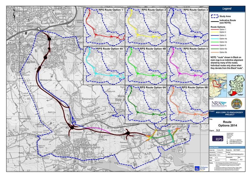
M28 Cork to Ringaskiddy Project
EIS - Volume 1: Non-Technical Summary

                                                   TABLE OF CONTENTS

NON TECHNICAL SUMMARY ......................................................................................................... 1
1          INTRODUCTION AND OVERVIEW ...................................................................................... 1
    1.1 OVERVIEW OF THE PROPOSED M28 ROAD PROJECT ............................................................................. 1
    1.2 REQUIREMENT FOR ENVIRONMENTAL IMPACT STATEMENT AND NATURA IMPACT STATEMENT ................... 3
2          NEED AND PROJECT OBJECTIVES ....................................................................................... 4
    2.1 POLICY 4
    2.2 ECONOMY ..................................................................................................................................... 5
    2.3 SAFETY 5
    2.4 ENVIRONMENT ............................................................................................................................... 6
    2.5 SUSTAINABILITY .............................................................................................................................. 6
    2.6 NEED FOR THE SERVICE AREA............................................................................................................ 6
    2.7 PROJECT OBJECTIVES ....................................................................................................................... 7
3          REASONABLE ALTERNATIVES EXAMINED .......................................................................... 8
           3.1.1 Assessment of Alternative Corridors ................................................................................. 8
           3.1.2 Assessment of Alternatives at a Strategic Level .............................................................. 10
           3.1.3 Assessment of Alternatives within the existing N28 corridor ......................................... 11
           3.1.4 Assessment of Alternatives at Preliminary Route Design Stage ..................................... 14
           3.1.5 Assessment of Alternative Sites for a Service Area ......................................................... 14
4          DESCRIPTION OF THE PROPOSED ROAD DEVELOPMENT .................................................. 15
    4.1 OVERVIEW ................................................................................................................................... 15
    4.2 PERMANENT LAND ACQUISITION ..................................................................................................... 16
    4.3 CONSTRUCTION ............................................................................................................................ 16
    4.4 COMPATIBILITY OF THE PROPOSED ROAD PROJECT WITH THE PROJECT OBJECTIVES ................................... 17
5          CONSULTATION ............................................................................................................. 19
6          ENVIRONMENTAL ASSESSMENT OF THE PROPOSED ROAD DEVELOPMENT ...................... 20
    6.1 HUMAN HEALTH AND SEVESO ........................................................................................................ 20
    6.2 TRAFFIC & TRANSPORTATION.......................................................................................................... 20
    6.3 SOCIO-ECONOMIC & COMMUNITY .................................................................................................. 22
    6.4 AGRICULTURE LAND USE ................................................................................................................ 23
    6.5 HYDROLOGY AND DRAINAGE .......................................................................................................... 23
    6.6 AQUATIC ECOLOGY ....................................................................................................................... 24
    6.7 SOILS, GEOLOGY AND HYDROGEOLOGY ............................................................................................ 25

MCT0597RP9033F01                                                                                                                                          i
M28 Cork to Ringaskiddy Project
EIS - Volume 1: Non-Technical Summary

    6.8 TERRESTRIAL ECOLOGY .................................................................................................................. 25
    6.9 AIR AND CLIMATIC FACTORS ............................................................................................................ 27
    6.10 NOISE AND VIBRATION ................................................................................................................... 28
    6.11 CUTURAL HERITAGE ...................................................................................................................... 29
    6.12 LANDSCAPE AND VISUAL ................................................................................................................. 30
    6.13 MATERIAL ASSETS.......................................................................................................................... 31
    6.14 INTERACTION AND INTER-RELATIONSHIPS OF IMPACTS ......................................................................... 31
    6.15 SCHEDULE OF ENVIRONMENTAL COMMITMENTS................................................................................ 32
    6.16 VIEWING THE ENVIRONMENTAL IMACT STATEMENT ........................................................................... 32
    6.17 SUBMISSION AND ORAL HEARING .................................................................................................... 32
    6.18 WHAT HAPPENS NEXT? .................................................................................................................. 33
    6.19 FURTHER INFORMATION ................................................................................................................ 33

                                                       LIST OF FIGURES

Figure 1.1: Proposed M28 Road Project Location .................................................................................. 2
Figure 3.1: Alternative Corridors............................................................................................................. 9
Figure 3.2: Route Corridor Options along the N28 ............................................................................... 12
Figure 3.3: Preferred Route Option for Proposed M28 Road Project .................................................. 13

                                                         LIST OF TABLES
Table 2-1: Defined Project Objectives .................................................................................................... 7
Table 3-1: Assessment of Strategic Level Options against Project Objectives ..................................... 10
Table 4-1: Compatibility of the proposed road with the Project Objectives ........................................ 17
Table 6-1: Forecast growth in travel demand ....................................................................................... 21

MCT0597RP9033F01                                                                                                                                    ii
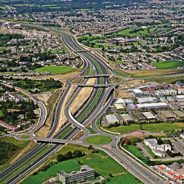
M28 Cork to Ringaskiddy Project EIS - Volume 1: Non-Technical Summary NON TECHNICAL SUMMARY 1 INTRODUCTION AND OVERVIEW Cork County Council (CCC), on behalf of the National Roads Authority (NRA), (known for operational purposes as Transport Infrastructure Ireland (TII)) propose to upgrade approximately 12.5km of the N28 National Primary Route from the N28/N40 South Ring Road Bloomfield Interchange to the Port of Cork in Ringaskiddy, together with consequential and ancillary works. CCC has made a Motorway Scheme, a Protected Road Scheme and a Service Area Scheme, which are being submitted for Approval to An Bord Pleanála under Section 49 of the Roads Act 1993 as amended and will be referred to throughout this report as, the proposed road project or the M28 Road Project. The Environmental Impact Statement (EIS) for the proposed M28 Road Project is “a statement of the effects, if any, which the proposed development, if carried out, would have on the environment” (EPA, 2015). The consideration and assessment of likely significant effects/impacts and the measures proposed to avoid, reduce and where possible, remedy significant adverse effects/impacts (mitigation measures), are based on the design of the road project as detailed in this EIS. The EIS as presented has been compiled by RPS on behalf of CCC with specialist assessment and reporting provided by a team of specialists (including sub consultants). The EIS contains the following documents: Volume 1 - Non Technical Summary Volume 2 - Main Text of the EIS Volume 3 - Natura Impact Statement Volume 4 - Appendices Volume 5 - Drawings & Figures This document forms Volume 1 – Non Technical Summary. 1.1 OVERVIEW OF THE PROPOSED M28 ROAD PROJECT In summary, the proposed M28 Road Project comprises a motorway route from the interchange with the N40 (Bloomfield Interchange) to the R613 Carrigaline to Ringaskiddy Road at Barnahely. From Barnahely, it comprises a single carriageway protected road that will link to the east side of Ringaskiddy village. A proposed Service Area will be located within the Port of Cork lands at Ringaskiddy that will primarily serve as a refuelling and rest area for commercial vehicles. The proposed M28 Road Project will form the TEN-T route to the Port of Cork complex at Ringaskiddy. The location of the proposed road is depicted on Figure 1.1 below and the layout is shown on Figure 3.3. MCT0597RP9033F01 1

M28 Cork to Ringaskiddy Project
EIS - Volume 1: Non-Technical Summary

Figure 1.1: Proposed M28 Road Project Location

MCT0597RP9033F01                                 2
M28 Cork to Ringaskiddy Project
EIS - Volume 1: Non-Technical Summary

1.2       REQUIREMENT FOR ENVIRONMENTAL IMPACT STATEMENT AND
          NATURA IMPACT STATEMENT

Mandatory Environmental Impact Assessment (EIA) is required because the proposed road
development includes a motorway and service area (as well as a protected road). The Environmental
Impact Statement has been submitted to An Bord Pleanála under Section 51 of the Roads Acts, for
which approval is sought.

Concurrently, a Natura Impact Statement (NIS) has been prepared for the purposes of Article 6 of
the Habitats Directive and to facilitate the Appropriate Assessment of the project by the Competent
Authority. The NIS concluded that with the implementation of best practice and the recommended
mitigation measures there will be no potential for direct, indirect or cumulative impacts arising from
the proposed M28 Road Project in combination with any other plans or projects. In summary, the
integrity of Cork Harbour SPA or the Great Island Channel SAC will not be adversely affected. The NIS
is contained within Volume 3 of the EIS and concludes a finding of no significant effects.

MCT0597RP9033F01                                                                                     3
M28 Cork to Ringaskiddy Project
EIS - Volume 1: Non-Technical Summary
2 NEED AND PROJECT OBJECTIVES
The existing N28 is predominantly a single carriageway road and suffers from significant congestion
leading to considerable delays and queuing at peak times at certain locations. The road does not
have the capacity to cater for current traffic volumes at peak times or future expected increases in
traffic.
The need for the proposed M28 Road Project is summarised below under headings of policy,
economy, safety, environment and sustainability.
2.1 POLICY
The overarching need for the proposed M28 Road Project derives from the requirements of
European and National Transportation and Port Access policies and is strongly underpinned in
national, regional and local planning policy.
At European level, the N28 is part of the TEN-T core network and it has been identified as a critical
part of the road network supporting the core maritime port at Ringaskiddy. TEN-T policy requires
that the route to the Port shall be a high quality route and according to European policy1, the TEN-T
core network shall consist of an express road or motorway that must:-
Be designed for motor traffic, accessible primarily from interchanges or controlled junctions;
and
Prohibit stopping and parking on the running carriageway.
The existing N28 does not achieve these specified standards and is in need of significant upgrade to
satisfy the TEN-T requirements.
At a national level, the National Ports Policy (NPP), published in 2013 represents government policy
in respect of the development of maritime trade in Ireland and identifies the Port of Cork as one of
only three Ports of National Significance (Tier 1) in Ireland. The National Development Plan (NDP)
2007-2013 and the National Spatial Strategy (NSS) (2002-2020) both recognise the importance of
the effective connections to the port and its associated industrial zones (refer to Section 2.2.1 and
Section 2.2.3 of Chapter 2: Planning and Policy Context).
Cork County and City Council have prepared a joint submission to the National Planning Framework
entitled “Cork 2050 Realising the Full Potential (March 2017)”. This document sets out various
strategies for the comprehensive and evidence based approach to the future development of Cork.
The Transport Strategy within this submission recognises the need for the M28 to connect
Ringaskiddy Port to the N40 which is of national importance.
The proposed M28 Road Project is identified in the recent Building on Recovery: Infrastructure and
Capital Investment 2016-2021 published by the Department of Public Expenditure and Reform which
sets out the Government’s framework for infrastructure investment up to 2021. One of the priorities
of the Plan is “targeting the improvement of specific road segments where there is a clear economic
1
REGULATION (EU) No 1315/2013, Chapters II and III, Articles 17 and 39
MCT0597RP9033F01 4
M28 Cork to Ringaskiddy Project
EIS - Volume 1: Non-Technical Summary
justification” and specifically makes provisions for the proposed road project (refer to Section 2.2.2
of Chapter 2: Planning and Policy Context).
The need for the proposed M28 Road Project is also supported by policy as set out in the following
documents: Department of Transport – Statement of Strategy 2016 to 2019, Investing in our
Transport Future: Strategic Framework for Investment in Land Transport (2015); the National Spatial
Strategy 2002 to 2020 (2002); Our Sustainable Future: A Framework for Sustainable Development
(2020); Smarter Travel – A Sustainable Transport Future, New Transport Policy for Ireland, 2009 -
2020 (2009); Cork 2050 Realising the Full Potential (March 2017); Building on Recovery:
Infrastructure and Capital Investment 2016-2021 .
At a regional and local level, the CDP 2014-2020 supports development of the road infrastructure
including the N28 as a project critical to the delivery of planned development. The draft Ballincollig-
Carrigaline Municipal District Local Area Plan, which is due to be adopted in August 2017, also
supports the proposed road development as an important catalyst for the economic development of
Cork and the South West region.
The policy basis for the need for the proposed M28 Road Project is set out in detail in the EIS
Chapter 2: Planning and Policy Context of the EIS in Volume 2.
2.2 ECONOMY
The proposed M28 Road Project will provide a high quality road for strategic port traffic and other
users, with capacity to cater for future demand to support growth of the Strategic Employment
Areas, Port of Cork, IMERC and tourism potential. This will improve the competitiveness and
efficiency of the economy both locally in the Ringaskiddy Peninsula, regionally and nationally. The
proposed M28 Road Project enables the relocation of port activities and related uses from the City
Docklands and Tivoli to new sustainable locations in the harbour, which is considered integral to
both the expansion of the Port of Cork and the planned redevelopment of the City Docklands
(Regional Planning Guidelines for the South West Region 2010 – 2022).
The proposed road project is a critical factor in maintaining and increasing the creation of
employment opportunities and for the future development of the Cork Region.
The economic arguments for prioritising investment into the upgrade of the N28 route as a key
infrastructural corridor of international as well as national, regional and local importance are
provided in the EIS Chapter 1: Introduction and Need for the Proposed Road Development.
2.3 SAFETY
A significant number of potential road safety and capacity issues have been identified with the
existing N28. The proposed M28 Road Project will result in:
Improved road safety, reduced number of road collisions and associated injuries/fatalities in the
N28 Corridor;
Improved transport infrastructure for local traffic and non-motorised road users by removing
traffic volumes from the existing N28;
MCT0597RP9033F01 5
M28 Cork to Ringaskiddy Project
EIS - Volume 1: Non-Technical Summary
Improved access to both the local and national network, which will improve accessibility to
work, education and other activities; and
Improved overall emergency response in the Ringaskiddy area.
Key elements of the proposed road project that will deliver safety improvements are described in
Chapter 1: Introduction and Need for the Proposed Road Development, Chapter 3: Description of
the Proposed Road Development and Chapter 5: Traffic and Transportation.
2.4 ENVIRONMENT
The proposed M28 Road Project will result in:
Increased road network capacity and improved travel conditions for both local and strategic
traffic;
Improved road safety;
Overall net reduction in the number of properties that will be exposed to air and noise
emissions;
Reduced community severance at Shanbally and Ringaskiddy villages;
Improved travelling environment on the existing N28; and
Improved access to the local and national network which will improve accessibility to work,
education and other activities.
2.5 SUSTAINABILITY
The upgrading of this route is required not only to protect the economic viability of the corridor but
also in support of the sustainability of the wider Cork region. The removal of large volumes of traffic
from the existing N28, as a result of the proposed M28 Road Project, will facilitate and encourage
the use of the existing N28 for alternative sustainable transport modes including cycling and walking,
with the added potential that the N28 would form part of a green-route. The provision of this high
quality link from the Port of Cork and the pharmaceutical industries at Ringaskiddy to the national
road network represents the most sustainable way to cater for freight and commercial traffic.
Key elements of the M28 Road Project that will deliver or facilitate the policy of sustainable and
smarter travel are detailed in the EIS in Chapter 3: Description of the Proposed Road Development
and Chapter 5: Traffic and Transportation.
2.6 NEED FOR THE SERVICE AREA
To comply with EU Directives and Regulations, it is necessary to provide safe and accessible facilities
where drivers can take necessary rest periods. Key policy and planning documents relating to the
requirements for a service area on the core national road network are included in the “Trans-
European Transport Network”; Regulation No 1315/2013, “TII (NRA) Service Area Policy” and the
“Spatial Planning and National Roads” guidelines.
MCT0597RP9033F01 6M28 Cork to Ringaskiddy Project
EIS - Volume 1: Non-Technical Summary
With the upgrade of the N28, the proposed M28 road will by-pass the current fuel station situated
on Carr’s Hill. From Cork to Ringaskiddy there will be no direct fuelling area on the M28.
The proposed Service Area at Ringaskiddy will provide users with safe rest, food, fuel and toilet
facilities and will contribute to meeting the requirements of European and National policy
documents and guidelines.
2.7 PROJECT OBJECTIVES
The project objectives are driven by the need to improve the current constraints associated with the
existing N28 (including congestion, noise, safety issues) and to meet the TEN–T requirements.
Predicted traffic growth between now and the future design year of 2035 will exacerbate these
existing issues if not addressed. The proposed project objectives are outlined in Table 2.1 below:
Table 2-1: Defined Project Objectives
Objective
To facilitate a reduction in the traffic-related impact of the existing N28 on the human
Environmental environment in the communities through which the road passes; and
To minimise the impact of any improvement works on nearby environmentally sensitive sites.
To improve road safety by reducing the number of road collisions and associated
Safety
injuries/fatalities in the N28 Corridor.
To facilitate the strategic development at the Port of Cork facilities at Ringaskiddy by
improving access for port-related traffic along the N28 corridor;
To reduce peak hour congestion and travel delays in the N28 corridor, at an investment cost
Economy that offers good value for money; and
To facilitate general economic development within the Cork Gateway and Ringaskiddy
Strategic Employment Area by improving journey time reliability on the N28 corridor at an
investment cots that offers good value for money.
To facilitate improved accessibility to the Ringaskiddy peninsula and associated employment
Accessibility opportunities for cyclists and other vulnerable road users; and
and Social
Inclusion To return to communities along the route such as Shanbally, easier and safer access to their
local facilities by the removal of strategic and through traffic from their environment.
To support the National Ports Policy (NPP) (2013) and Trans-European Network – Transport
Integration (TEN-T) policy by creating a High-Quality Route from the Port at Ringaskiddy to the N40 South
Ring Road.
The project design seeks to achieve these objectives while also ensuring that environmental impacts
are minimised, it seeks to provide sustainable transport modes, such as pedestrian and cyclist
facilities and connectivity to the Cork region. As can be seen above, the design and improvement
works not only comprise specific traffic related improvements, but also include the consideration of
additional sustainable transport modes including pedestrian and cyclist facilities.
MCT0597RP9033F01 7M28 Cork to Ringaskiddy Project
EIS - Volume 1: Non-Technical Summary
3 REASONABLE ALTERNATIVES EXAMINED
A number of alternatives were examined for the proposed project at various stages of project
development including:
Alternative Corridor Assessment;
Strategic Alternatives including:
Do-Nothing/Do minimum;
Traffic Management Alternative (TMA); and
Major Investment Option.
Route corridor options;
Junction strategy/layout options; and
Service Area locations.
3.1.1 Assessment of Alternative Corridors
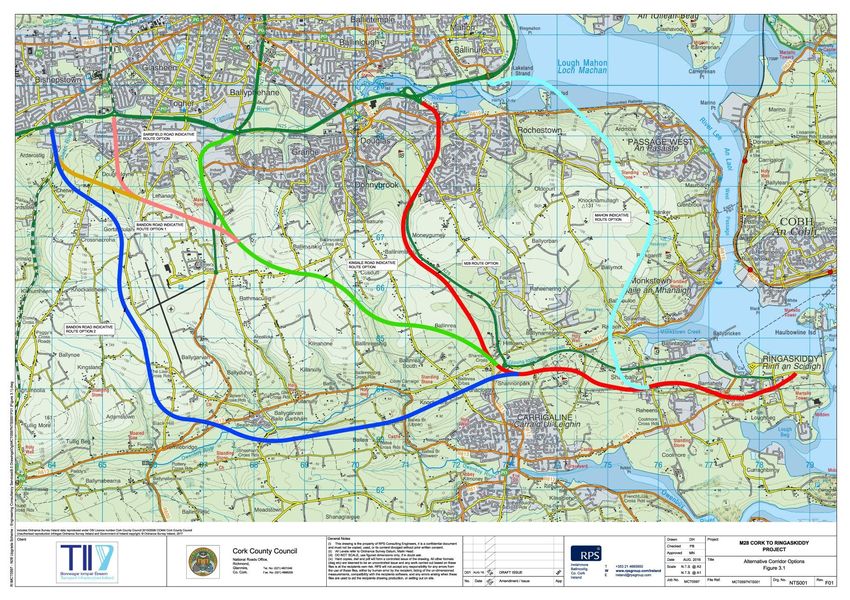
The study team considered a number of alternative corridors to the N28 as outlined in Figure 3.1
below, including the following options:
Upgrade from Kinsale Road Interchange to Shannonpark;
Upgrade from Sarsfield Road Interchange to Shannonpark;
Two options to upgrade from the Bandon Road Interchange to Shannonpark; and
Upgrade from Mahon Interchange to Shanbally.
Analysis of traffic modelling indicates that a significant amount of traffic generated would remain on
the existing N28 should an alternative corridor be developed, therefore congestion and adverse
noise impacts similar to those currently being experienced would still remain and exacerbate. The
assessment of the alternative corridors found that the proposal to upgrade within the existing N28
corridor best meets the project objectives in relation to environment, economy, safety, accessibility
& social inclusion and integration.
MCT0597RP9033F01 8M28 Cork to Ringaskiddy Project EIS - Volume 1: Non-Technical Summary Figure 3.1: Alternative Corridors MCT0597RP9033F01 9
M28 Cork to Ringaskiddy Project
EIS - Volume 1: Non-Technical Summary

3.1.2 Assessment of Alternatives at a Strategic Level

At a strategic level, the following alternatives were considered and assessed against the defined
project objectives:

Table 3-1: Assessment of Strategic Level Options against Project Objectives

      Option                     Description                    Summary of assessment against project objectives

                                                           Accessibility & Social Inclusion: Will not improve access to
                       Do-Nothing Option - Assumes         employment centres on the Ringaskiddy peninsula and will
                       no other investment in the          not provide safer access for local communities.
                       transport network other than        Integration: Does not integrate with national and European
                       regular maintenance during          policy.
Do-Nothing/Do-         the study period.
Minimum                                                    Environment: Does not resolve existing traffic and noise
                       Do-Minimum Option is the            issues.
                       ‘Do-Nothing’ option plus any        Economy: Does not cater for existing and future
                       transportation improvements         development of IDA lands, Strategic Employment Area in
                       in the study area that are          Ringaskiddy, Port of Cork, future housing and will not result in
                       committed to or planned.            improved travel times.
                                                           Safety: Will only provide for localised safety improvements.
                       Comprises measures such as:-
                                                           Accessibility & Social Inclusion: Will not achieve objectives of
                       The removal of bottlenecks          improving access to employment centres on the Ringaskiddy
                       through     targeted  local         peninsula and safer access for local communities.
                       investment;
                                                           Integration: Does not integrate with national and European
                       Local     road            safety    policy.
                       improvements;
Traffic                                                    Environment: Preferred in terms of avoiding impacts to
Management             Fiscal or Traffic Control
                       measures to manage traffic          natural resources. However, will not reduce air emissions and
Alternative                                                noise associated with existing and future traffic congestion.
                       demand; and
                                                           Economy: Limited capacity to cater for existing and future
                       Public Transport        Priority,   growth and development of IDA lands, Strategic Employment
                       capacity     and/or       public    Area in Ringaskiddy, Port of Cork, Housing etc.
                       transport services                  Safety: Will only        provide    for   minor/local    safety
                                                           improvements.

                                                           Accessibility and Social Inclusion: Will remove significant
                                                           traffic volumes from the existing N28 and reduce severance
                                                           in villages such as Shanbally and Ringaskiddy. Provides
                                                           benefits for pedestrians and cyclists by providing a safer N28.
                                                           Integration: Meets the requirements of European, national
                                                           and local Policy.
Major Investment       Upgrading within the existing       Environment: Overall net reduction in exposure to air and
Option                 N28 Corridor                        noise and improved employment opportunities. There are
                                                           some negative impacts to landscape and local ecological
                                                           resources which would be expected from any project of this
                                                           nature.
                                                           Economy: Significant transportation time savings and
                                                           benefits.
                                                           Safety: Significant improvement to safety.

MCT0597RP9033F01                                                                                                          10
M28 Cork to Ringaskiddy Project EIS - Volume 1: Non-Technical Summary The assessment of the three strategic options indicated that a Major Investment Option of upgrading within the existing N28 corridor was the preferred option. 3.1.3 Assessment of Alternatives within the existing N28 corridor Cork County Council (CCC) and their agents had, between 2004 and 2007, developed an improvement scheme to upgrade the N28 between Bloomfield Interchange and Ringaskiddy Village to emerging preferred route corridor stage. Following a period of postponement, work was reinitiated on the M28 Cork to Ringaskiddy Project in 2013. The route selection process as carried out up to 2013 was reviewed and eight route corridor options were identified, as shown on Figure 3.2. In accordance with the government’s Common Appraisal Framework for transport schemes, these eight route corridor options were assessed in detail under five core criteria: Accessibility & Social Inclusion, Integration, Environment, Economy and Safety. The assessment included looking at local variations in three areas, one area between Carr’s Hill and Shannonpark; one area at Ballyhemiken; and the final area at Ringaskiddy. The results of the appraisal concluded that the Core Route (Option 2) using the localised quarry alternative at Ballyhemiken (from Option 5) and extending to Ringaskiddy using Option 6b was the least constrained option and was the best fit to meet the project objectives. The outcome from the route selection process, the preferred route corridor, was brought forward to the route design stage and outcome of this is shown on Figure 3.3. MCT0597RP9033F01 11
M28 Cork to Ringaskiddy Project
EIS - Volume 1: Non-Technical Summary

Figure 3.2: Route Corridor Options along the N28

MCT0597RP9033F01                                   12
M28 Cork to Ringaskiddy Project
EIS - Volume 1: Non-Technical Summary

Figure 3.3: Preferred Route Option for Proposed M28 Road Project

MCT0597RP9033F01                                                   13
M28 Cork to Ringaskiddy Project
EIS - Volume 1: Non-Technical Summary

3.1.4 Assessment of Alternatives at Preliminary Route Design Stage

Following the emergence of the preferred route corridor option and consultation with the public,
various junction strategies and design layouts were assessed at the northern section near Carr’s Hill,
at Shannonpark and at Old Post Office Road in the southern section. All options were assessed under
the following headings; local traffic impact, economy, safety, environment, accessibility & social
inclusion and integration. The proposed M28 Road Project as presented in Figure 3.3 represents the
best balance of road safety, social, environmental and economic issues, while achieving the scheme
objectives. A summary of the option assessment undertaken for the various junctions is presented
in Chapter 4: Outline of Alternatives.

3.1.5 Assessment of Alternative Sites for a Service Area

A number of options were assessed along the proposed road for the inclusion of a Service Area. The
primary objective of the service area is to provide fuel and rest facilities on a 24-hour basis for
commercial vehicles. A Service Area Site Options Assessment was carried out to determine the best
location to facilitate the proposed Service Area. Site options were considered with regard to
environmental constraints and engineering criteria and the preferred site was selected on the basis
that it best serves its purpose with the least environmental impact. The site that emerged as the
most suitable for the proposed Service was the Port Option (SA3). This site complies with TII policy
for the provision of services for vehicles travelling long distances. Its location within the Port will
primarily serve those travelling to and from the Port of Cork itself and minimise local use, thus
limiting any increase in short local trips.

Details of all alternatives assessed are provided in the EIS Chapter 4: Outline of Alternatives.

MCT0597RP9033F01                                                                                     14
M28 Cork to Ringaskiddy Project
EIS - Volume 1: Non-Technical Summary
4 DESCRIPTION OF THE PROPOSED ROAD DEVELOPMENT
4.1 OVERVIEW
The proposed M28 Road Project will consist of the construction, operation and maintenance of 10.9
kilometres of dual carriageway motorway from the N40 Bloomfield Interchange to Barnahely, 1.5
kilometres of single carriageway protected2 road from Barnahely to the eastern side of Ringaskiddy
and a Service Area at the Port of Cork facility at Ringaskiddy together with ancillary and
consequential works.
An overview is shown on Figure 3.3 and comprises;
10.9km of mainline motorway from Bloomfield to Barnahely;
1.5km of mainline single carriageway protected road from Barnahely to east of Ringaskiddy;
4.8km of new and realigned regional and local roads;
2.2km of accommodation works tracks;
1 full grade-separated interchange at Carr’s Hill with associated roundabouts, slip roads and
widening of the existing underbridge at Carr’s Hill;
3 partial grade-separated interchanges at Bloomfield/Rochestown Road, Shannonpark and
Shanbally, with associated roundabouts and slip roads, including 2 new underbridges, existing
bridge at Rochestown retained as part of the scheme;
3 at-grade roundabouts at Barnahely, Loughbeg and eastern Port of Cork entrance;
Provision of a M28 to N40 westbound link road and improvement of the westbound merge
from the M28 to the N40;
Removal of the existing sub-standard northbound on-ramp at Maryborough Hill;
Upgrading of the existing sub-standard off-ramp to Mount Oval;
4 new road underbridges to allow the proposed M28 to pass over existing roads;
1 underbridge widening at Carr’s Hill;
2 shared use pedestrian and cyclist underpasses, one at Carr’s Hill and one at Old Post Office
Road;
Demolition of the existing Maryborough Hill overbridge and construction of a replacement
overbridge at the same location. This overbridge will take Maryborough Hill over the widened
M28 below;
Various other structures including large retaining walls and stream culverts;
Traffic signalised control to be implemented at key junctions on Rochestown Road, including
the replacement of the Rochestown Road roundabout with a signalised junction, signalising of
the merge to the M28 and signalising of the Clarke’s Hill junction;
Local road improvements and parallel access roads, etc;
Accommodation works and farm accesses as required;
Provision for footpaths and cycle facilities;
Relocation of high voltage electricity pylons at Shanbally;
Drainage system, including attenuated outfalls, watercourse culverts and realignments;
Landscaping and environmental mitigation measures; and
2
No access points other than designated junctions will be permitted to this road.
MCT0597RP9033F01 15M28 Cork to Ringaskiddy Project
EIS - Volume 1: Non-Technical Summary
A Service Area for commercial vehicles including amenity building, fuel facilities, parking etc.
within the Port of Cork lands at Ringaskiddy.
4.2 PERMANENT LAND ACQUISITION
The provision of the M28 Road Project requires the acquisition of land for the construction and
operation of the development. The area of land required is determined by a number of related
parameters including:
Road construction;
Construction of verges, embankments, cuttings, utilities, footpaths, roundabouts, drainage
realignments, drainage facilities, structures, landscaping, deposit areas, accommodation roads,
work space, boundary treatment, maintenance strip and ancillary road construction and
operation requirements;
Accommodation and access roads;
Acquisition of severed plots; and
Ecological, landscaping and noise mitigation requirements.
Approximately 142 hectares of land is included in the Motorway, Protected Road and Service Area
schemes and is considered necessary for its construction and operation.
4.3 CONSTRUCTION
It is expected the construction of the proposed road project will take approximately 30-36 months.
During this period there will be beneficial impacts on the local economy as a result of employment
and the use of local materials and facilities. There will however, be localised temporary disruption on
local communities resulting from the construction of the road. These impacts will be of a short-term
duration over the construction period and will often be localised. To reduce impacts, the works will
be carried out in compliance with best practice guidelines and mitigation measures for the
construction phase as set out in this EIS, NIS and any Approval/Consent as may be granted.
The preparation of the Construction Traffic Management Plan will include measures to ensure that
construction related traffic will not contribute to the existing peak hour traffic congestion problems.
There will be a requirement that construction related traffic will be restricted from entering the local
road network during the AM (07.45-09.00) and PM (17.00-18.00) commuter peak periods.
The Contractor will be required to complete an Environmental Operating Plan (EOP) in accordance
with NRA Guidelines on Environmental Operating Plans. The EOP will set out the contractor’s
approach to managing environmental issues associated with the construction of the road and
provide a documented account of the implementation of the environmental commitments set out in
the EIS, NIS and any measures by way of conditions or restrictions in any Approval/Consent as may
be granted.
MCT0597RP9033F01 16M28 Cork to Ringaskiddy Project
EIS - Volume 1: Non-Technical Summary
The EOP will:-
Incorporate all Environmental Commitments/Mitigation measures set out in this EIS and any
other conditions/restrictions attached to approval as may be granted by statutory bodies (i.e.
NPWS).
Incorporate any relevant conditions/restrictions as may be imposed through the statutory
approval of/consent for the proposed road development;
Provide a method of documenting compliance with these Environmental Commitments/
Mitigation measures;
List all relevant environmental legislation requirements and provide a method of documenting
compliance with these requirements; and
Outline methods by which construction works will be managed to avoid, reduce or remedy
potential adverse impacts on the environment.
4.4 COMPATIBILITY OF THE PROPOSED ROAD PROJECT WITH THE PROJECT
OBJECTIVES
An assessment of the proposed development and its compatibility with the projects defined
objectives is outlined in Table 4.1 below.
Table 4-1: Compatibility of the proposed road with the Project Objectives
Objective Compatibility with Objectives
Overall a net decrease in the impact of road
To facilitate a reduction in the traffic- traffic noise on properties after the
related impact of the existing N28 on the construction of the road project.
human environment in the communities
Environmental through which the road passes; No significant indirect or direct impacts
To minimise the impact of any improvement predicted to Natura 2000 sites, nationally
works on nearby environmentally sensitive protected sites cultural heritage sites,
sites. geological heritage sites etc.
Improves road safety with a predicted
reduction in the number of road collisions
and associated injuries/fatalities.
To improve road safety by reducing the
Safety number of road collisions and associated Improves safety along the existing roads
injuries/fatalities in the N28 Corridor and at junctions/accesses.
Improves safety by separating local traffic
movements from strategic traffic.
To facilitate the strategic development at Provides high quality road for strategic port
the Port of Cork facilities at Ringaskiddy by traffic and other users with capacity to cater
improving access for port-related traffic for future demand to support growth of the
Economy along the N28 corridor; Strategic Employment Areas, Port of Cork,
To reduce peak hour congestion and travel IMERC and tourism potential.
delays in the N28 corridor, at an investment
cost that offers good value for money; and Improves the competitiveness and
MCT0597RP9033F01 17M28 Cork to Ringaskiddy Project
EIS - Volume 1: Non-Technical Summary
Objective Compatibility with Objectives
To facilitate general economic development efficiency of the economy both locally in the
within the Cork Gateway and Ringaskiddy Ringaskiddy Peninsula and nationally.
Strategic Employment Area by improving Reduces peak hour congestion and travel
journey time reliability on the N28 corridor delays on the N28 Corridor at an investment
at an investment cots that offers good value cost that offers value for money.
for money.
Significant reduction of traffic volumes on
the existing N28 provides the opportunity
for improved walking and cycling facilities
along this corridor.
Facilitates sustainable transport, i.e., local
Greenway initiatives and removing traffic
from the existing N28.
To facilitate improved accessibility to the
Ringaskiddy peninsula and associated
Improves access to both the local and
employment opportunities for cyclists and
national network which will improve
other vulnerable road users; and
Accessibility accessibility to work, education and other
and Social activities.
Inclusion To return to communities along the route
such as Shanbally, easier and safer access to Traffic reduction in the villages of Shanbally
their local facilities by the removal of and Ringaskiddy will ensure safer and easier
strategic and through traffic from their access to local facilities.
environment.
Provides high quality access to Strategic
Employment Area.
Improves the overall emergency response in
the Ringaskiddy area (Seveso Report, RPS,
2017).
TEN-T requirements for route protection,
To support the National Ports Policy (NPP) prohibition and design for motor traffic are
(2013) and Trans-European Network – achieved by motorway status.
Integration Transport (TEN-T) policy by creating a High-
Quality Route from the Port at Ringaskiddy
to the N40 South Ring Road. Proposed road complies with European,
National, Regional and Local Plans.
MCT0597RP9033F01 18M28 Cork to Ringaskiddy Project
EIS - Volume 1: Non-Technical Summary
5 CONSULTATION
Consultation is an important component of the overall project development process. The project
team has a responsibility to ensure that members of the public and all interested organisations have
the opportunity to provide feedback on the project at all key stages in order to inform and
strengthen the project’s decision-making process.
The general public, interested parties and statutory and non-statutory bodies have been involved in
the development of the proposed M28 Road Project as part of non-statutory consultation at key
stages, including:
Non-statutory public consultation on the Preferred Route Corridor, December 2014;
Informal consultation with statutory and non-statutory organisations on the EIA Scoping Report,
March 2015;
Non-statutory public consultation on the Carr's Hill Interchange and associated works,
November 2015;
Non-statutory public consultation on the Preferred Route Alignment and Junction Strategy for
the M28 Cork to Ringaskiddy Motorway Project, April 2016;
Informal consultation with statutory and non-statutory organisations on the Health Study
Scoping Statement, February 2017;
Informal pre-planning meetings with An Bord Pleanála;
Ongoing informal consultation with stakeholders (including the Inland Fisheries Ireland,
National Parks and Wildlife Service, utility providers); and
Public Display of Preferred Route for the M28 Cork to Ringaskiddy Project, April 2017.
All feedback received during these consultations, as well as other meetings that took place with the
design engineers, the environmental consultants and various statutory bodies, landowners, resident
groups and interested parties throughout the process has been reviewed by the project team and
taken into consideration in the development of the M28 Road Project and this EIS. Details of all non-
statutory consultation are provided in the EIS Chapter 6: Non-Statutory Consultation.
MCT0597RP9033F01 19M28 Cork to Ringaskiddy Project
EIS - Volume 1: Non-Technical Summary
6 ENVIRONMENTAL ASSESSMENT OF THE PROPOSED ROAD
DEVELOPMENT
The design of the proposed M28 Cork to Ringaskiddy Project has been developed through an
iterative process that in the first instance sought to avoid impact on the environment. Where
avoidance was not possible every effort was made to minimise the environment impacts. The
proposed road project has been evaluated by a team of specialist contributors who have considered
the existing environment of the study area and have assessed in detail the potential effects of the
project. Where potential environmental impacts are identified, mitigation measures have been
included in the proposals to further reduce the potential environmental impacts.
A brief summary of each specialist examination is provided below. For a more detailed consideration
of the studies the reader is referred to the EIS (Volume 2).
6.1 HUMAN HEALTH AND SEVESO
A health study was undertaken to draw from, supplement and interpret the findings of the technical
assessments within the EIS. A review of the EIS demonstrates that the proposed project is designed
to address existing hazards, offering a net reduction in community exposure from emissions to air
and noise and improving road safety over and above what can be achieved through the alternative
of no change to the road. In addition, the proposed road project seeks to address congestion,
improve connectivity between residential and employment areas and supporting sustainable
development.
An assessment of the likely significant effect of the proposed development on the COMAH3 (Seveso
sites) network was also undertaken to ensure the proposed road did not pose a risk to existing
facilities in the area. The report concluded that at the operational stage, the proposed new
infrastructure will have no direct impact on the COMAH establishments in the area and will not alter
the risk profile of these operations. The reduced travel time on the proposed M28 will facilitate a
faster response time for emergency medical services from Cork University Hospital and/or additional
fire services if required from Ballincollig. As a result, the new infrastructure will improve the overall
emergency response in the Ringaskiddy area and have a net slight positive impact in the area.
6.2 TRAFFIC & TRANSPORTATION
A detailed traffic and transportation study has been undertaken for the M28 Road Project using the
most up to date SATURN transportation models for the Cork region. The study draws on previous
work including the N40 Demand Management Study, Douglas LUTS, Port of Cork Traffic modelling
and the N28 Sustainable Transport Study.
There are existing peak hour traffic problems in the local road network. The N40 South Ring Road is
busy in both directions in the morning and evening peak periods. The N28 also experiences traffic
peaks in both directions in both peak hours. This is primarily due to travel to and from the
established residential areas of Douglas/Rochestown/Passage West and Carrigaline travelling to and
from employment areas in the City/Little Island and in the Ringaskiddy peninsula. Traffic from the
3
Control of Major Accident Hazards (COMAH)
MCT0597RP9033F01 20M28 Cork to Ringaskiddy Project
EIS - Volume 1: Non-Technical Summary
wider Cork region also travels to and from the employment areas in Ringaskiddy. Local trips, e.g,
school runs also add to the travel demand in the morning peak. The result of this demand is frequent
congestion and delay on the N40, N28 and the local road network in Douglas/Rochestown and
Carrigaline.
To model the traffic patterns on the existing road network, standard methods of calibration and
validation have been applied based on measured traffic counts and journey times. The peak periods
are modelled as 3 individual hours to capture the reality of the existing situation where the morning
peak typically extends for 2.5 hours between 07.00 and 10.00 and the evening peak similarly extends
some 2.5 hours over the period 16.00 to 19.00. The model also includes for inter-peak hours to fully
model the typical traffic patterns over a typical day.
Bottlenecks on the existing N28 include the northbound merge from Rochestown Road, northbound
merge from Maryborough Hill, Shannonpark Roundabout and the mini roundabout in Shanbally. The
local road network in Douglas/Rochestown also suffers congestion with particular bottlenecks
occurring at the merge/diverge junction on Rochestown Road, Clarke’s Hill, Fingerpost roundabout
and on Maryborough Hill. Within Carrigaline there are also local constraints leading to congestion at
local junctions.
Constraints on the N40 primarily consist of disruption resulting from traffic merging and diverging to
and from a number of key interchanges including Mahon Interchange, Douglas slip roads and Kinsale
Road Interchange. The existing Dunkettle Interchange is also a considerable bottleneck.
Traffic modelling for the project includes forecasts of future traffic demand. Models are developed
for Do Minimum and Do Scheme scenarios for a notional year of opening of 2020 and horizon year
of 2035. Traffic growth is considered based on TII Project Appraisal Guidelines for the region,
distributed in accordance with the land use planning policy in the Carrigaline Electoral Area Local
Area Plan.
The forecast growth in travel demand (Relative to Base Year 2014) is summarised in the following
Table 6.1.
Table 6-1: Forecast growth in travel demand
Growth Scenario 2020 2035
Low 7.3% 17.7%
Medium 9.9% 26.0%
High 11.2% 29.8%
In relation to port generated trade related traffic, HGV trips were assessed based on the predictions
carried out by the Port of Cork in relation to the recently approved development proposal at
Ringaskiddy. An upper trade growth scenario was applied to the high growth scenario, an average
trade growth scenario was applied to the medium growth scenario and a no additional development
scenario was applied to the low growth scenario.
MCT0597RP9033F01 21M28 Cork to Ringaskiddy Project EIS - Volume 1: Non-Technical Summary Without the proposed road in place, traffic demand continues to grow based on the predicted forecast scenarios. Congestion and delay increase in the peak periods, which typically continue to lengthen. In particular, peak period traffic congestion is predicted to increase on the N40, the northern section of the N28 and the local road network in Douglas/Rochestown. With the implementation of the proposed M28 Road Project, there will be a significant improvement in the traffic capacity in the M28 corridor together with rearranged access provisions through the proposed Carr’s Hill interchange. The principal impact is to divert considerable traffic volumes to the proposed road, providing considerable relief to the existing N28 between Carr’s Hill and Ringaskiddy. This has a significant positive impact, particularly for the communities that reside in Shanbally and Ringaskiddy. Other north-south routes including Donnybrook Hill, Moneygourney Road and the L6477 are also predicted to be significantly relieved as traffic reassigns to the proposed motorway. At the northern end of the scheme, the impact of the road is more complex. In the peak periods, traffic chooses routes using the M28 junction on Rochestown Road, Carr’s Hill Interchange or routes through Douglas via Douglas Road or via South Douglas Road to access to and from the area. Even though the local road network remains extremely busy, there is an overall improvement in the network performance. The traffic analysis predicts there will be overall increases in traffic demand to and from Carr’s Hill Interchange with increased daily traffic flows predicted on the R609, Garryduff Road, Clarke’s Hill (south of Mount Oval village) and on Maryborough Hill (north of the proposed road). Other routes in the area including Rochestown Road, Clarke’s Hill (north of Mount Oval) and Maryborough Hill (adjacent to Broadale) are predicted to have a decrease in daily flows. In all cases the indicative link capacity in the area can cater for the predicted traffic demand. The key local junctions will continue to be over capacity in the peak periods. The impact in the Douglas village area is predicted to be negligible. The proposed road increases transport efficiency through improved capacity and the removal of bottlenecks, benefits freight transport and facilitates the implementation of alternative transport modes. In particular the existing N28 can be developed to support and encourage walking and cycling after the road project is implemented. Public transport is also facilitated by increased road capacity by providing greater journey time certainty, encouraging greater use of alternative transport modes to the car. The proposed road does not sever existing transport routes and it also facilitates the development of sustainable schemes such as the Carrigaline Monkstown Greenway. 6.3 SOCIO-ECONOMIC & COMMUNITY There will be significant positive effects in terms of employment as a result of the estimated 400 direct construction jobs generated during the construction phase of the project. This will have knock on positive effects for the local economy and communities given the construction stage capital value of the project and associated indirect jobs generated as a result. Some businesses along the route may experience levels of diminution/severance as a result of the proposed road project, however the existing roads will remain open to traffic and much of the hinterland passing trade will remain. There will be unavoidable short term and localised impacts on the resident, working and visiting community during the construction phase of the proposed project including increased levels of noise and dust associated with the construction process, visual impacts and some diversions and delays to road users along the route. These impacts will be minimised through careful planning and application of the mitigations measures set out in the EIS including the requirement to prepare various traffic, noise and dust management plans prior to and during the construction stage. MCT0597RP9033F01 22
M28 Cork to Ringaskiddy Project
EIS - Volume 1: Non-Technical Summary

In terms of land take there will not be a substantial loss of land within the northern section of the
route as the existing N28 will be widened at this location. Within the central and southern part of
the route, greenfield lands will however be acquired to facilitate the proposed M28 Road Project. In
total four properties will be included within the CPO, two of which will be demolished, to facilitate
the road project. Loss of land and property will be addressed through agreements between Cork
County Council and relevant land and property owners and/or statutory compensation. While the
proposed M28 Cork to Ringaskiddy Project will have both positive and negative impacts on resident,
working and visiting communities, the impacts will be predominantly positive in the long term due to
reduced journey times, improved accessibility and access to sustainable modes of transport.
Increased accessibility to and from the Ringaskiddy area will make the zoned lands within this area
more attractive to investors, likely resulting in increased employment opportunities within the area,
which would support the role of Ringaskiddy as a Strategic Employment Area. There is also potential
for significant growth within Cork City as a result of the relocation of the Port of Cork to Ringaskiddy
Port once the road is in place, leading to a significant positive indirect long term impact.

6.4       AGRICULTURE LAND USE

The proposed road project will be constructed along the existing route and across agricultural lands
and will cause a level of disturbance to these farms. The project team have been in discussions with
landowners and have, where possible, identified issues and concerns that these landowners may
have. Based on these discussions and design constraints the project team have, where practicable,
minimised the landtake and degree of severance affecting each farm. Other potential impacts
affecting soil compaction, drainage, noise and dust have been considered and assessed in the main
EIS and appropriate mitigation measures outlined.

The proposed road will not have a significant impact on agriculture from a national or regional
perspective. It will have an impact from a local perspective due to loss of agricultural land. However,
the proposed scheme, once mitigated by accommodation works will have a permanent residual
impact on 33 landowners with varying degrees of significance.

While accommodation works will mitigate many residual impacts, not all can be mitigated in this
manner and the remainder will be addressed by way of statutory compensation.

6.5       HYDROLOGY AND DRAINAGE

The works will involve the construction of a new surface water drainage system for the proposed
road including new outfalls to existing watercourses, existing surface water drainage networks and
discharge to the foreshore. Furthermore, the proposed road project will cross a number of local
watercourses, necessitating stream realignments, new culvert crossings and extensions to existing
culverts.

The proposed stream diversions, culverts, surface water drainage network, and catchment run-off
interceptors have been designed, in accordance with TII design standards, so as to minimise the
potential impact on the receiving watercourses.

The proposals will result in an increase in impermeable surfacing which has the potential to increase
the rate of run-off to receiving watercourses. In addition, routine run-off may contain pollutants that
can have an adverse impact on water quality within the receiving watercourses. The proposed

MCT0597RP9033F01                                                                                      23
You can also read