SEPA Environmental Checklist (WAC 197-11-960) - 145th Street Multimodal Corridor Project - City of Shoreline
←
→
Page content transcription
If your browser does not render page correctly, please read the page content below
SEPA Environmental Checklist (WAC 197-11-960)

                                 145th Street Multimodal Corridor Project

                                                                   June 2020
                                                 City of Shoreline, Washington

Document Title
145th Street Multimodal Corridor Project

145th Street Multimodal Corridor Project

Project No:        696236CH.AA.07.10
Document Title:    SEPA Environmental Checklist (WAC 197-11-960) 145th Street Multimodal Corridor
                   Project
Document No.:      FES0414200816PDX
Revision:          Draft
Date:              June 2020
Client Name:       City of Shoreline, Washington
Project Manager:   John McKenzie, PE
Author:            Kim Varner Wetzel, AICP

Jacobs Engineering Group Inc.

1100 112th Avenue NE, Suite 500
Bellevue, Washington 98004
United States
T +1.425.453.5000
www.jacobs.com

                                                            SEPA Environmental Checklist (WAC 197-11-960)
                                                                                     FES0414200816PDX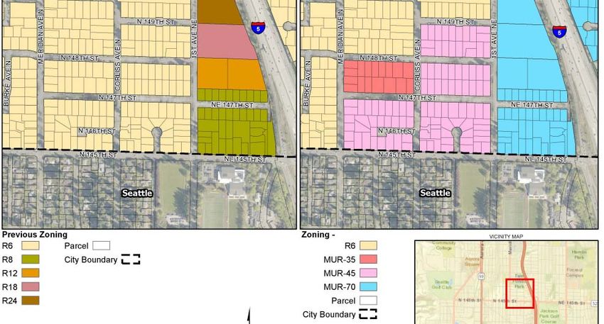
145th Street Multimodal Corridor Project

Contents
SEPA Environmental Checklist (WAC 197-11-960) 145th Street Multimodal Corridor Project ........... 1
      A.     Background ......................................................................................................................... 1
      B.     Environmental Elements ..................................................................................................... 6
             1.      Earth ....................................................................................................................... 6
             2.      Air ........................................................................................................................... 8
             3.      Water ...................................................................................................................... 9
             4.      Plants ................................................................................................................... 12
             5.      Animals ................................................................................................................ 13
             6.      Energy and Natural Resources ............................................................................ 14
             7.      Environmental Health ........................................................................................... 14
             8.      Land and Shoreline Use ...................................................................................... 16
             9.      Housing ................................................................................................................ 19
             10.     Aesthetics............................................................................................................. 20
             11.     Light and Glare..................................................................................................... 21
             12.     Recreation ............................................................................................................ 21
             13.     Historic and Cultural Preservation ....................................................................... 21
             14.     Transportation ...................................................................................................... 23
             15.     Public Services..................................................................................................... 25
             16.     Utilities.................................................................................................................. 25
      C.     Signature ........................................................................................................................... 26

Tables
Table 1. Project Construction Phases........................................................................................................... 3
Table 2. Government Approvals and Permits for the Project ....................................................................... 4
Table 3. Key Project Features ...................................................................................................................... 5
Table 4. Impervious Surface Estimates and Stormwater Requirements by Threshold Discharge Area ...... 8
Table 5. Proposed Stormwater Facility Locations ...................................................................................... 11
Table 6. Hazardous Materials Potential Sites of Concern .......................................................................... 14
Table 7. Level of Service Results for AM Peak and PM Peak Hours, Year 2022 No Build and Year 2040
          No Build/Build ............................................................................................................................... 24

Figures
1          Project Vicinity.................................................................................................................................. 2
2          Construction Phasing ....................................................................................................................... 2
3          Project Extent ................................................................................................................................... 6
4          Proposed Stormwater Facility Locations........................................................................................ 12
5a         Project Area Zoning (Shoreline) ..................................................................................................... 17
5b         Project Area Zoning (Seattle) ......................................................................................................... 17
5c         Project Area Zoning, Bitter Lake Village Hub Detail (Seattle Comprehensive Plan)………………18
6          Steep Slopes within Project Area................................................................................................... 19
7          Historic Properties within Project Area........................................................................................... 22
8          Level of Service Intersections ........................................................................................................ 25

SEPA Environmental Checklist (WAC 197-11-960)                                                                                                                 i
FES0414200816PDX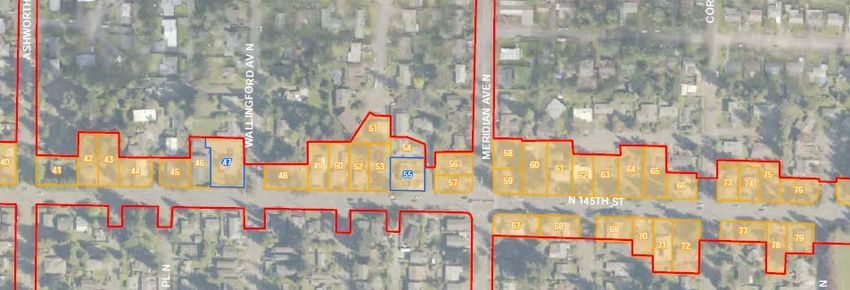
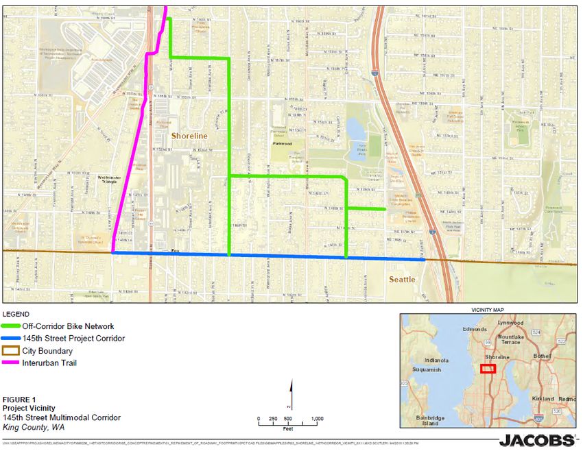
145th Street Multimodal Corridor Project

SEPA Environmental Checklist (WAC 197-11-960)
145th Street Multimodal Corridor Project
A. Background
1.   Name of proposed project, if applicable:

145th Street Multimodal Corridor Project (Project)

2.   Name of applicant:

City of Shoreline, Washington

3.   Address and phone number of applicant and contact person:
Robert Victor, Project Manager
City of Shoreline
17500 Midvale Avenue N
Shoreline, WA 98133
(206) 801-2451

4.   Date checklist prepared:

June 2020

5.   Agency requesting checklist:

The City of Shoreline will serve as lead agency and the City of Seattle will be a reviewing agency.

6.   Proposed timing or schedule (including phasing, if applicable):

Construction of the 145th Street Multimodal Corridor is scheduled in phases. Phase 1 construction will
begin in 2023 and facilities will be operational in 2024. Phase 2 construction will begin in 2024 and
facilities will be operational in 2025. Phase 3 construction will begin in 2027 and facilities will be
operational in 2028 pending funding availability.

For context, this State Environmental Policy Act (SEPA) Checklist encompasses the entire 145th Street
Multimodal Corridor from Interstate 5 (I-5) to Linden Avenue North (Ave N) at the Interurban Trail (just
west of Aurora Ave N/State Route [SR] 99) and includes off-corridor bike network improvements. Figure 1
is a vicinity map that shows the 145th Street Project corridor and off-corridor bike network. Figure 2
provides a closer view of the construction phasing within the corridor. Table 1 provides a detailed look at
the construction phasing and schedule.

SEPA Environmental Checklist (WAC 197-11-960)                                                             1
FES0414200816PDX
145th Street Multimodal Corridor Project

Figure 1. Project Vicinity

Figure 2. Construction Phasing

2                                SEPA Environmental Checklist (WAC 197-11-960)
                                                          FES0414200816PDX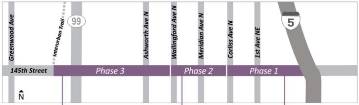
145th Street Multimodal Corridor Project
Table 1. Project Construction Phases
Phase 1 Phase 2 Phase 3
I-5 to Corliss Ave N Corliss Ave N to Wallingford Wallingford Ave N to Linden
Ave N Ave N
30% Design (complete) February 2019
National Environmental Policy Act
Summer 2020
Approval
Right-of-Way Acquisition 2020-2021 2022-2023 2024-2025
100% Design 2021-2022 2023-2024 2026
Construction 2023-2024 2024-2025 2027-2028
Begin Operations 2024 2025 2028
7. Do you have any plans for future additions, expansion, or further activity related to or
connected with this proposal? If yes, explain.
The Project is designed for 30 years based on population projections. The City of Shoreline has proposed
the Project as part of a series of improvements from Route 522 to 3rd Ave Northwest (NW), implemented
by other agencies that will improves pedestrian and bicycle mobility, safety and operations, transit speed
and reliability, and freight mobility issues for the region.
8. List any environmental information you know about that has been prepared, or will be
prepared, directly related to this proposal.
A series of technical memos have been prepared in support of the proposal and are cited within this
document. They are available for review by request from the City of Shoreline during the comment period.
145th Street Multimodal Corridor Study (City of Shoreline, 2016)
Environmental Existing Conditions Report (Jacobs, 2018)
Geotechnical Design Report (Jacobs, 2019)
Pavement Design Memo (Jacobs, 2019)
Preliminary Stormwater Report (Jacobs, 2019)
Preliminary Structure Design Memo (Jacobs, 2019)
Relocation Plan (Jacobs, 2019)
Traffic Noise Analysis (Jacobs, 2019)
Cultural Resources Technical Report (Jacobs, 2020)
Environmental Justice Report (Jacobs, 2020)
Hazardous Materials Technical Memorandum (Jacobs, 2020)
Land Use Review (Jacobs, 2020)
Traffic Analysis Report (Jacobs, 2020)
SEPA Environmental Checklist (WAC 197-11-960) 3
FES0414200816PDX145th Street Multimodal Corridor Project
9. Do you know whether applications are pending for governmental approvals of other
proposals directly affecting the property covered by your proposal? If yes, explain.
The Project site is under review by the City of Shoreline, City of Seattle, and Washington Department of
Transportation (WSDOT). Rights-of-way will be established with the City of Shoreline, City of Seattle, and
WSDOT. No other proposed projects are under review for this site.
10. List any government approvals or permits that will be needed for your proposal, if known.
Table 2 provides a list of government approvals and permits needed for the Project.
Table 2. Government Approvals and Permits for the Project
Approval/Permit Type Agency
Federal and State Approvals and Permits
NEPA, Class II Determination of Categorical Exclusion Washington Department of Transportation on behalf of Federal
Highway Administration
Right-of Way Work Permit Washington State Department of Transportation (WSDOT)
National Pollutant Discharge Elimination System (NPDES) Ecology/ US Environmental Protection Agency (EPA)
Construction Stormwater General Permit and Coverage
Cultural Resources Assessment for compliance with Section WSDOT and Washington State Department of Archaeology
106 of the National Historic Preservation Act and Historic Preservation (DAHP)
Notice of Proposed Construction or Alteration (Form 7460.1) Federal Aviation Administration
Local Approvals and Permits
State Environmental Policy Act (SEPA) City of Shoreline
Street Use Permit (hybrid) City of Seattle
Right-of-Way Use Permit City of Seattle
Significant-Sized Trees and Street Tree Removal Permits City of Shoreline
11. Give brief, complete description of your proposal, including the proposed uses and the size
of the project and site. There are several questions later in this checklist that ask you to
describe certain aspects of your proposal. You do not need to repeat those answers on this
page.
The Project proposes improvements in two major categories: roadway improvements and bike network
improvements. Upgrades to the roadway infrastructure including adding left-turn lanes, landscape buffers,
and wider sidewalks, and improving pedestrian and bicycle mobility, safety and operations, transit speed
and reliability, and freight mobility. The Project also proposes an off-corridor bike network to guide
bicyclists of all ages and abilities along the network, support traffic calming, and provide safe crossings at
arterials. The dimensions and purposes of the two key Project features of roadway and bike network are
listed as follows and summarized in Table 3:
Pavement resurfacing
Full depth pavement replacement from Meridian Ave N to the I-5 Interchange
New sidewalks on the north side of 145th Street from the Interurban Trail to the I-5 Interchange
New landscape buffer on the north side of 145th Street between Aurora Ave N and I-5 that includes
street trees
New Americans with Disabilities Act (ADA) curb ramps to meet current design standards at all
intersections within the corridor
Lengthened left-turn pocket on the west leg of the intersection with Aurora Ave N
4 SEPA Environmental Checklist (WAC 197-11-960)
FES0414200816PDX145th Street Multimodal Corridor Project
New left-turn pockets at all legs of the intersections with Meridian Ave N and 1st Ave N:
– Two new or modified traffic signals as a result of the new left turn pockets: Meridian Ave N and
1st Ave N
Two new pedestrian crossing signals:
– 145th Street and Ashworth Ave N, Corliss Ave N
Installation of joint utility trench and undergrounding overhead power and telecom under the north
sidewalk on 145th Street from Meridian Ave N to the I-5 Interchange
New fill retaining walls at various locations along the north side of the roadway where widening will
occur
New raised medians at various locations between Wallingford Ave N and the I-5 Interchange
Replaced stormwater management system including new flow control and runoff treatment
New lighting poles and luminaires within the sidewalk/landscape amenity zone on the north side of
the Project corridor from Linden Ave N to I-5 and on the south side of the Project corridor from
Meridian Ave N to I-5
New bus zone improvements including ADA-accessible pads, bus shelters, pedestrian lighting, and
real-time information system pylons
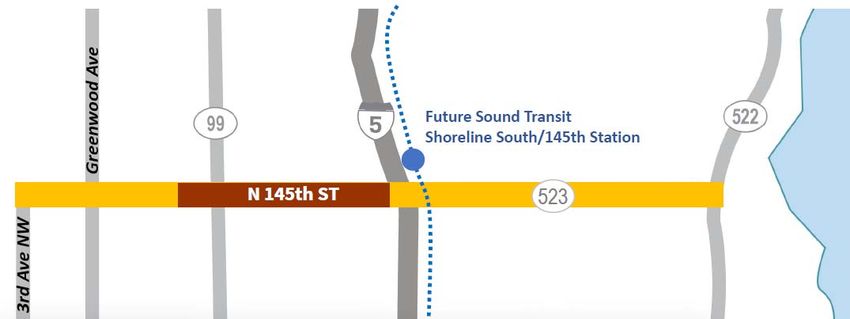
New off-corridor bike network to connect the Interurban Trail and west-end neighborhoods with the
future Sound Transit 145th Street Link light rail station. The off-corridor network would travel on
existing roadways with limited Project improvements including wayfinding signs, painted arrows,
speed humps, and traffic islands. Curb ramps would also be improved at two intersections. All
proposed improvements are located within existing right-of-way.
The Project improvements along the 145th Street corridor will require right-of-way property acquisition
predominantly in the City of Shoreline, and partial (“sliver”) acquisition for ADA improvements in the City
of Seattle. According to the Relocation Plan, the proposed Project will result in the partial or full
acquisition of 51 parcels of which 19 property acquisitions are anticipated to require the displacement of
22 residential (11 owner occupants and 11 tenant occupants), 9 nonresidential (7 landlords and 2
nonresidential businesses) and 1 personal property only. The Project requires excavation below the
existing paved surfaces: approximately 4.5 to 8 feet for lighting poles, 8 to 15 feet for traffic signals
depending on soil conditions, 5 feet for storm conveyance system, and 5 feet for the utility trench.
Table 3. Key Project Features
Project Feature Approximate Dimensions Purposes
Roadway Improvements Bus shelters Provide better transit amenities
Turn pockets Remove stopped cars from flow of traffic
Street and Pedestrian Lighting Relocate for roadway improvements and update for
current design standards. Provide better lighting for
pedestrian facilities.
Underground Utilities Provide better aesthetics by removing clutter from
streetscape, in alignment with zoning and
municipal code requirements
Storm Drainage Improvements Ensure detention and treatment to address
additional impervious surface added
Replace signals at 1st and Meridian Improve turn pockets and provide better traffic flow
intersections
Landscaping Improve aesthetics and city gateway features
Structural Retaining Walls Address grading and property interface
Curb ramps Address ADA requirements
SEPA Environmental Checklist (WAC 197-11-960) 5
FES0414200816PDX145th Street Multimodal Corridor Project
Project Feature Approximate Dimensions Purposes
Bike Network Improvements Wayfinding signs, painted arrows Guide bicyclists of all ages and abilities along the
network
Speed humps, traffic islands Provide traffic calming
Signalized crossings and curb ramps Facilitate safe crossing for bikes at major arterials
12. Location of the proposal. Give sufficient information for a person to understand the precise
location of your proposed project, including a street address, if any, and section, township,
and range, if known. If a proposal would occur over a range of area, provide the range or
boundaries of the site(s). Provide a legal description, site plan, vicinity map, and topographic
map, if reasonably available. While you should submit any plans required by the agency, you
are not required to duplicate maps or detailed plans submitted with any permit applications
related to this checklist.
The Project is located along a segment of N/NE 145th Street from the east side of the Interurban Trail at
Linden Ave N to the west side of the interchange with I-5 (shown in Figure 1 as well as in Figure 3). The
south half of the existing roadway is in Seattle, King County, Washington (Section 19, Township 26 North,
and Range 4 East, Willamette Meridian). The north half of the existing roadway is located in
unincorporated King County, Washington (Section 18, Township 26 North, and Range 4 East, Willamette
Meridian) within the Thornton Creek watershed.
Figure 3. Project Extent
B. Environmental Elements
1. Earth
a. General description of the site:
The Project study area covers approximately a 1-mile section along N 145th Street between Aurora Ave
N/SR 99 and I-5. The Project area is a rolling terrain bound by residential properties to the north and
south and includes its current pavements and sidewalks, existing retaining walls, and slopes.
Stormwater generally flows along both curb lines into storm drains. Storm drains generally discharge to
side streets on the north side of the roadway.
b. What is the steepest slope on the site (approximate percent slope)?
6 SEPA Environmental Checklist (WAC 197-11-960)
FES0414200816PDX145th Street Multimodal Corridor Project
Elevations ranges from 484 feet above mean sea level on the western edge of the Project (Aurora Ave N/SR 99)
to approximately 341 feet on the eastern edge of the Project (I-5). The roadway slope of the site is no more than
8.0 percent. Steep slopes in two specific areas are discussed in question 8h.
c. What general types of soils are found on the site (for example, clay, sand, gravel, peat,
muck)? If you know the classification of agricultural soils, specify them and note any
agricultural land of long-term commercial significance and whether the proposal results in
removing any of these soils.
Existing borings and test pits found the Project area is underlain by Till and Outwash deposits. No
groundwater was encountered during geotechnical explorations, but perched water may be present within
the Till. (Three borings were drilled to depths of approximately 20 feet.) There will be soil removal for
widening the roadway and for retaining walls on the north side of the road. There will also be excavation
for signal foundations, stormwater conveyance, stormwater management facilities (detention vault and
pond), and utility undergrounding.
d. Are there surface indications or history of unstable soils in the immediate vicinity? If so,
describe.
Soils have moderate to high strength, low to moderate compressibility, and appear to be good
embankment and subgrade material for pavement support with high susceptibility to changes in moisture
content and high erosion potential.
Pavements and sidewalks are damaged considerably by tree roots producing depression or heave in the
subgrade. Longitudinal and transverse asphalt cracks could be fatigue cracking as a result of a
combination of repetitive traffic loading, nonuniformities or low stiffness in materials (e.g., base, subbase,
and subgrade) beneath the pavement and sidewalks, moisture influences, or freeze/thaw effects.
e. Describe the purpose, type, total area, and approximate quantities and total affected area of
any filling, excavation, and grading proposed. Indicate source of fill.
The Project will require approximately 4,950 cubic yards of excavation of pavement and pavement base
for complete pavement resurfacing. Fill is estimated at 8,910 cubic yards for widening the road to the
north. It does not include new pavement or pavement base. The total area of ground disturbance is
293,000 square feet, representing all of the area where subgrade will be disturbed for proposed
improvements.
Site preparation activities will include the excavation of existing soil material and placement of structural fill
material utilizing typical earthmoving equipment that may include hydraulic excavators, scrapers, dump
trucks, and compactors. Structural engineering fill, gravel base course, and asphalt will be imported from
permitted sources.
f. Could erosion occur as a result of clearing, construction, or use? If so, generally describe.
Slopes will be protected from erosion and construction traffic, and materials set back from the edge of
the slopes by a minimum of 10 feet unless specifically accounted for in the design. The contractor will be
responsible for continually observing the conditions of the slope, surcharge, and slope protection. The
stormwater drainage system (including a bioretention facility) will manage the rain/surface water from the
surface and impervious areas. Because site soil is susceptible to erosion, best management practices
(BMPs) for temporary stormwater management will be implemented.
No cumulative impacts to soils or erosion are expected from the Project because construction will comply
with applicable temporary erosion and sedimentation control provisions of the Shoreline City Code and an
NPDES Construction Stormwater General Permit Stormwater Pollution Prevention Plan. The drainage
design will accommodate the future phase’s runoff. For example, a detention facility will be installed
during Phase 1 construction to accommodate some Phase 2 runoff.
SEPA Environmental Checklist (WAC 197-11-960) 7
FES0414200816PDX145th Street Multimodal Corridor Project
g. About what percent of the site will be covered with impervious surfaces after project
construction (for example, asphalt or buildings)?
The amount of existing impervious surface area within study area limits is 353,132 square feet. The
Project will add approximately 61,828 new square feet of impervious surface area. Table 4 provides
additional detail regarding Project estimates for impervious surfaces from the Preliminary Stormwater
Report (Jacobs, 2019).
Table 4. Impervious Surface Estimates and Stormwater Requirements by Threshold
Discharge Area
Threshold Discharge Area Flow Runoff
Added Control Treatment
Existing Added Impervious Required Required LID
Impervious Runway Surface (EFF IS > (EFF PGIS > Feasibility
Name Area Surface (EFF PGIS) (EFF IS) 10,000 SF?) 5,000 SF?) Required?
Interurban Trail 38,922 35,790 1,264 2,462 N N N
Stone Ave N 87,484 80,562 81 6,428 N N N
Ashworth Ave N 49,763 41,494 172 7,734 N N N
Meridian Ave N 64,308 52,835 4,876 9,375 N Y Y
1st Ave NE 127,792 96,922 17,220 25,694 Y Y Y
WSDOT 57,353 45,529 6,276 10,135 Y Y Y
Total 425,622 353,132 29,890 61,828
Notes:
EFF = effective; IS = impervious surface; LID = low-impact design; PGIS = pollutant generating impervious surface; SF = square
foot/feet; Y = Yes and N = No
h. Proposed measures to reduce or control erosion, or other impacts to the earth, if any:
There will be a Temporary Erosion and Sediment Control Plan and a Stormwater Pollution Prevention
Plan (SWPPP) required due to more than 5,000 square feet of added impervious surface and more than
1 acre of disturbance. During construction, erosion control BMPs required by municipal code and the
Stormwater Management Manual for Western Washington (Ecology, 2019) will be employed. The BMPs
include enhanced level runoff treatment, oil control, flow control, and LID (if feasible).
Table 3-2 in the Preliminary Stormwater Report (Jacobs, 2019) summarizes the minimum stormwater
requirements for the entities sharing jurisdiction over stormwater design. The 30% concept design meets
the requirements of the Engineering Design Manual, Highway Runoff Manual, Surface Water Master Plan
(City of Shoreline, 2018). Strategies include bioretention and enhanced runoff treatment levels. During
final design, an operation and maintenance (O&M) plan will be adopted with an applicable agreement per
the Revised Code of Washington.
2. Air
a. What types of emissions to the air would result from the proposal during construction,
operation, and maintenance when the project is completed? If any, generally describe and
give approximate quantities if known.
Construction
Temporary air quality impacts during construction will include construction machinery exhaust emissions,
primarily from particulate matter less than 10 micrometers and 2.5 micrometers in aerodynamic diameter
(PM10 and PM2.5, respectively), and from small amounts of carbon monoxide and oxides of nitrogen. The
8 SEPA Environmental Checklist (WAC 197-11-960)
FES0414200816PDX145th Street Multimodal Corridor Project
sources of particulate matter might be fugitive dust from clearing, excavation activities, uncovered fill
stockpiles, diesel smoke, or any combination of these sources.
Some construction activities may cause odors. Paving operations use tar and asphalt. The construction
contractor must comply with Ecology Northwest Clean Air Agency regulations requiring the control of
odorous emissions to prevent interference with adjacent uses. These types of odors will be short‐term
and unlikely to impact adjacent uses.
Operation of Multimodal Corridor
Emissions during operation of the multimodal corridor will result from the combustion of fossil fuels from
vehicles. Traffic is expected to increase over the life of the project, but the design features will mitigate
some idling associated with congestion.
Greenhouse Gas
The multimodal corridor potential contribution to global climate change will be through emission of
greenhouse gases (GHG), primarily CO2. The net change in CO2 emissions due to construction has not
been quantified. It is estimated there will be some modal shifts due to the new bicycle network, new bus
service, shelters and improved connections to the light rail station. Therefore, the will be no discernible
new impacts to the climate from operation of the corridor.
b. Are there any offsite sources of emissions or odor that may affect your proposal? If so,
generally describe.
No offsite sources of emissions or odor have been identified that may affect this proposal.
c. Proposed measures to reduce or control emissions or other impacts to air, if any:
During construction, BMPs for Project impacts to air quality, odor, and GHG emissions could include, but
would not be limited to the following:
Spraying water, when necessary, during construction operations to reduce emissions of fugitive dust
Covering dirt, gravel, and debris piles as needed to reduce fugitive dust and wind‐blown debris
Covering open‐bodied trucks, wetting materials in trucks, or providing adequate freeboard (space
from the top of the material to the top of the truck) to reduce fugitive dust emissions
Turning off construction equipment when not in use to minimize idling and reduce GHG emissions
Replanting vegetation temporarily disturbed by construction activities with native vegetation within 1
year or growing season after construction was complete
3. Water
a. Surface Water:
1) Is there any surface water body on or in the immediate vicinity of the site (including year-
round and seasonal streams, saltwater, lakes, ponds, wetlands)? If yes, describe type
and provide names. If appropriate, state what stream or river it flows into.
Surface Water Bodies
There are no surface water bodies in the immediate vicinity of the Project. The off-corridor bike network is
adjacent to Twin Ponds Park, which is just over 0.25 mile from 145th Street. The southern pond is about
350 feet from the off-corridor bike network. The north branch of Thornton Creek is east of Aurora Avenue
N and runs parallel to the off-corridor street bicycle network carrying stormwater east until it reaches the I-
5 right-of-way at approximately N 150th Street. Thornton Creek runs under I-5 within a pipe.
SEPA Environmental Checklist (WAC 197-11-960) 9
FES0414200816PDX145th Street Multimodal Corridor Project
Wetlands
There are no wetlands in the Project area.
2) Will the project require any work over, in, or adjacent to (within 200 feet) the described
waters? If yes, please describe and attach available plans.
There will be no work within 200 feet of a pond or piped creek. (Thornton Creek is piped under I-5,
approximately 300 feet from the east end of the Project.)
3) Estimate the amount of fill and dredge material that would be placed in or removed
from surface water or wetlands and indicate the area of the site that would be affected.
Indicate the source of fill material.
The current design will not fill any surface waters or wetlands.
4) Will the proposal require surface water withdrawals or diversions? Give general
description, purpose, and approximate quantities if known.
The current design does not propose surface water withdrawal or diversion.
5) Does the proposal lie within a 100-year floodplain? If so, note location on the site plan.
The Project does not lie within a 100-year floodplain.
6) Does the proposal involve any discharges of waste materials to surface waters? If so,
describe the type of waste and anticipated volume of discharge.
Discharges of waste materials to surface waters will not occur.
b. Groundwater:
1) Will groundwater be withdrawn from a well for drinking water or other purposes? If so,
give a general description of the well, proposed uses and approximate quantities
withdrawn from the well. Will water be discharged to groundwater? Give general
description, purpose, and approximate quantities if known.
Groundwater will not be withdrawn from a well for use in the Project.
2) Describe waste material that will be discharged into the ground from septic tanks or
other sources, if any (for example: Domestic sewage; industrial, containing the
following chemicals…; agricultural; etc.). Describe the general size of the system, the
number of such systems, the number of houses to be served (if applicable), or the
number of animals or humans the system(s) are expected to serve.
The current design does not utilize septic tanks.
c. Water runoff (including stormwater):
1) Describe the source of runoff (including stormwater) and method of collection
and disposal, if any (include quantities, if known). Where will this water flow?
Will this water flow into other waters? If so, describe.
Stormwater runoff is the only source of water runoff expected at the site.
Stormwater flows to the north branch of Thornton Creek, which then flows into Lake Washington.
Thornton Creek is located within the I-5 right-of-way; however, the creek is located within a pipe.
10 SEPA Environmental Checklist (WAC 197-11-960)
FES0414200816PDX145th Street Multimodal Corridor Project
2) Could waste materials enter ground or surface waters? If so, generally describe.
There is a possibility that small amounts of waste materials (i.e., petroleum products, sediments, or
concrete materials) could occur from construction and operation activity. Spill prevention BMPs will be
followed during construction to avoid such spills.
3) Does the proposal alter or otherwise affect drainage patterns in the vicinity of the site? If
so, describe.
The site will utilize existing drainage patterns and increase the stormwater detention capacity in order to
accommodate future phases of the Project. The existing gradient is 0.5 to 8.0 percent. Grading will mirror
this gradient to maximize gravity flow of stormwater to the stormwater facilities.
d. Proposed measures to reduce or control surface, ground, and runoff water, and drainage
pattern impacts, if any:
The construction contractor will implement both a SWPPP and a temporary erosion and sediment control
plan, in accordance with an NPDES General Construction Stormwater Permit. These approved plans will
include a list of BMPs that will be in place before construction begins, along with erosion control
measures (silt fences, check dams, silt/sediment basins and traps) and plans for erosion control through
grading. Revegetation plans will be implemented at the end of construction.
Existing storm drains and structures will be replaced or adjusted to convey stormwater from the roadway
improvements. Additional catch basins and associated storm drains will be placed to meet spacing
requirements, based on preliminary calculations using the WSDOT Inlet Calculation Spreadsheet and the
Highway Runoff Manual. In general, they are placed along the reconstructed portion of 145th Street on
the north side. On the south side, City of Seattle structures were located near the improved intersections.
The drainage conveyance elements should be refined as the design progresses, and when the interface
with the I-5 interchange project is known.
Three parcels were identified as strategic stormwater management sites where BMPs for TDAs will be
constructed to manage flow and water quality treatment (Table 5 and Figure 4). The parcels were
selected based on TDA (location), collaborative opportunity, and availability. Stormwater facilities will be
owned and maintained by the City of Shoreline. Maintenance features such as easy access is a City
concern. The urban design and stormwater design teams have collaborated in identifying the parcels to
maximize their potential benefits.
Table 5. Proposed Stormwater Facility Locations
Proposed BMPs
Stormwater
TDA Management Site Flow Control Runoff Treatment
Meridian Ave 1 None Bioretention cell (noninfiltrating)
1st Ave 2 Detention vault Modular wetland treatment unit
WSDOT 3 Stormwater detention pond Bioretention cell (noninfiltrating)
(infiltrating)
SEPA Environmental Checklist (WAC 197-11-960) 11
FES0414200816PDX145th Street Multimodal Corridor Project
Figure 4. Proposed Stormwater Facility Locations
Onsite stormwater management techniques including bioretention, permeable surface, and amended soil
depths in the planting areas may be suitable LID techniques. These will be specified with further
geotechnical information and other design refinements are made.
A joint agency O&M plan for the multimodal corridor will be created and adopted. The O&M plan will be
an agreement addressing the long-term maintenance of the stormwater facilities that will be constructed
onsite to deal with the flow control and treatment requirements of Core Element 5 in the Stormwater
Management Manual for Western Washington (Ecology, 2019).
4. Plants
a. Check the types of vegetation found on the site:
X Deciduous tree: alder, maple, aspen, other
X Evergreen tree: fir, cedar, pine, other
X Shrubs
X Grass
Pasture
Crop or grain
Orchards, vineyards or other permanent crops.
Wet soil plants: cattail, buttercup, bullrush, skunk cabbage, other
Water plants: water lily, eelgrass, milfoil, other
Other types of vegetation
The site is an urbanized area where the vegetation consists of exotic and native ornamental trees,
grasses, and shrubs.
b. What kind and amount of vegetation will be removed or altered?
The Project will result in the removal and replacement of plants listed above. An estimated 1.66 acres of
yard/landscaping will be impacted by the Project, mostly on private property that will be acquired by the
12 SEPA Environmental Checklist (WAC 197-11-960)
FES0414200816PDX145th Street Multimodal Corridor Project
City of Shoreline. An estimated 0.67 acre of landscaping strip along the corridor between the roadway
and sidewalk will be added, which will include shrubs/groundcover and street trees.
c. List threatened and endangered species known to be on or near the site.
The Project will not impact any Endangered Species Act (ESA) listed species or critical habitat. The
Project is located within a completely urbanized area and the properties to be acquired do not contain any
critical habitat or threatened and endangered species.
d. Proposed landscaping, use of native plants, or other measures to preserve or enhance
vegetation on the site, if any:
Vegetation temporarily disturbed by construction activities will be replaced. The new landscaping strip will
be designed in compliance with City of Shoreline code after construction is complete. New landscaping
on the south side of the road at multiple intersections will be design in compliance with City of Seattle
code.
More details including the revegetation/landscaping plan to meet City of Shoreline design criteria will be
determined during the final design.
e. List all noxious weeds and invasive species known to be on or near the site.
A field survey of vegetation was not conducted, but the Project site is contained within an urbanized area
consisting of planned and maintained exotic and native ornamental trees, grasses and shrubs. As such,
no noxious weeds or invasive species are known to be on or near the site.
5. Animals
a. List any birds and other animals which have been observed on or near the site or are known
to be on or near the site.
Examples include:
birds: hawk, heron, eagle, songbirds, other ____________
mammals: deer, bear, elk, beaver, other ____________
fish: bass, salmon, trout, herring, shellfish, other ____________
No ESA-listed species are present in the Project’s study area nor is any designated critical habitat
present in the study area. The Project is located within a completely urbanized area and the properties to
be acquired do not contain any habitat or species. No animals were observed during a site visit in
October 2018.
b. List any threatened and endangered species known to be on or near the site.
No threatened or endangered species are known to be on or near the Project site.
c. Is the site part of a migration route? If so, explain.
There was no analysis of migration routes because the Project lies in an urbanized area.
SEPA Environmental Checklist (WAC 197-11-960) 13
FES0414200816PDX145th Street Multimodal Corridor Project
d. Proposed measures to preserve or enhance wildlife, if any:
Proposed measures to reduce impacts to wildlife include lighting design that is pointed down to avoid
attraction from birds and movement-sensitive temporary construction buildings’ lighting to reduce lighting
attractants.
Utilities will be buried to comply with development code and reduce clutter in the corridor, which can also
reduce migratory bird injury and the creation of predator bird roosts or nests.
e. List any invasive animal species known to be on or near the site.
There was no analysis of invasive animal species because the Project lies in an urbanized area.
6. Energy and Natural Resources
a. What kinds of energy (electric, natural gas, oil, wood stove, solar) will be used to meet
the completed project's energy needs? Describe whether it will be used for heating,
manufacturing, etc.
Construction will require electricity and diesel fuel. A small diesel generator will be onsite to keep the
construction shelter operational during power outages.
b. Would your project affect the potential use of solar energy by adjacent properties?
If so, generally describe.
No, the potential use of solar energy by adjacent properties will not be affected.
c. What kinds of energy conservation features are included in the plans of this proposal? List
other proposed measures to reduce or control energy impacts, if any:
The streetlights and transit shelters will utilize LED lights.
There are no other built features requiring energy as part of the Project.
7. Environmental Health
a. Are there any environmental health hazards, including exposure to toxic chemicals, risk of
fire and explosion, spill, or hazardous waste, that could occur as a result of this proposal? If
so, describe.
1) Describe any known or possible contamination at the site from present or past uses.
Based on a review of Ecology’s Facilities Database that lists known or potential hazardous material sites
or landfills, there are 25 hazardous material sites in the study area (Jacobs, 2020). Of these sites, two
sites were identified as sites of potential concern for the Project (Table 6). The remaining 23 sites are
eliminated from further consideration due to their distance from the Project alignment, lack of documented
release, or cleanup has been completed (e.g., received a no further action determination).
Table 6. Hazardous Materials Potential Sites of Concern
Site Name Address Status
Aurora Texaco 14507 Aurora Ave N Cleanup started. This site is considered as
moderate risk because contaminated soil is
known to remain on site just north of the area
proposed for acquisition. Additional
contaminated soil could also be located within
the area proposed for acquisition.
14 SEPA Environmental Checklist (WAC 197-11-960)
FES0414200816PDX145th Street Multimodal Corridor Project
Site Name Address Status
Pepper Hill Shopping 14701 Aurora Ave N Voluntary clean-up site. This site is
Center considered as low risk because it is located
about 200 feet north of the Project alignment
and the shallow groundwater is perched and
discontinuous and therefore not expected to
impact the project during construction.
2) Describe existing hazardous chemicals/conditions that might affect project development
and design. This includes underground hazardous liquid and gas transmission pipelines
located within the project area and in the vicinity.
There is the potential to encounter contaminated soils in the northwest corner of the 145th Street and
Aurora Ave N intersection. The Aurora Texaco property in the northwest corner had up to 6 leaking
underground storage tanks that have been removed and the soils excavated. Contaminated soils were
identified less than 40 feet north of an area proposed for acquisitions by Ecology in 2013. The Hazardous
Materials Memorandum (Jacobs, 2020) estimates there is a moderate risk of encountering contaminated
soil which could delay construction.
3) Describe any toxic or hazardous chemicals that might be stored, used, or produced
during the project's development or construction, or at any time during the operating life
of the project.
Hot mix asphalt, paint, and fuel will be stored and used at the Project site during construction. No
hazardous chemicals will remain onsite after Project construction.
4) Describe special emergency services that might be required.
No special emergency services will be required.
5) Proposed measures to reduce or control environmental health hazards, if any:
Proposed measures to reduce or control environmental health hazards include the implementation of
BMPs and preparation of a health and safety plan, a Spill Prevention, Containment, and
Countermeasures Plan; and a SWPPP.
The Hazardous Materials Technical Memo will be included in the bid materials and a Moderate Risk
Waste section will be included in the project specifications. It would require excavated soils to be
sampled by the contractor or their subcontractor prior to disposal to determine contaminants.
Contaminated soil would be hauled offsite to an approved disposal location. Construction activities
would use BMPs for the safe handling and disposal of contaminated soil, if encountered. b. Noise
1) What types of noise exist in the area which may affect your project (for example:
traffic, equipment, operation, other)?
The daytime and nighttime sound levels in the Project vicinity come from 145th Street. Other noise
sources in the surrounding area include State Route 99 to the west and I-5 to the east.
2) What types and levels of noise would be created by or associated with the project on a
short-term or a long-term basis (for example: traffic, construction, operation, other)?
Indicate what hours noise would come from the site.
Construction
Construction activities will result in temporary noise increases within and adjacent to the Project area. The
short-term noise and vibration impacts will be generated primarily by mobile equipment (e.g., excavators,
SEPA Environmental Checklist (WAC 197-11-960) 15
FES0414200816PDX145th Street Multimodal Corridor Project
backhoes), stationary equipment (e.g., generators, compressors) and vehicle traffic. Typical construction
activities will occur during daytime hours between 7 a.m. and 10 p.m. when property-line noise limits do
not apply. Allowable nighttime noise levels are reduced by 10 decibels on an A-weighted scale (dBA)
from 10 p.m. to 7 a.m. on weekdays and 10 p.m. to 9 a.m. on weekends.
Operation
The Traffic Noise Analysis Memorandum (Jacobs, 2019) determined no noise barriers are recommended
because increases in noise levels associated with the Project are below WSDOT’s definition of a
substantial increase.
3) Proposed measures to reduce or control noise impacts, if any:
Construction
Because construction noise levels will be variable and short-term, contractors will implement the following
measures to minimize noise from construction activities:
Operate equipment during approved hours as required by local permits.
Minimize idling time of heavy equipment and vehicles.
Ensure adequacy of mufflers on all engines (vehicle and generators).
Operation
None planned.
8. Land and Shoreline Use
a. What is the current use of the site and adjacent properties? Will the proposal affect current
land uses on nearby or adjacent properties? If so, describe.
Within the Shoreline city limits, existing land uses in the Project area are primarily single-family
residential. There are some areas of multifamily residential and areas of commercial focused along the
Aurora Ave N/SR 99 corridor. The existing uses in the City of Seattle are similar to Shoreline with
primarily single-family residential adjacent to 145th Street and area of commercial uses adjacent to the
Aurora Ave N/SR 99 corridor.
A portion of the Project area (north of 145th) was up-zoned in 2016 to allow for greater densities and a mix
of uses between Meridian Ave N and I-5 and to encourage transit-supportive development nearest the
future light rail station at 148th Street and I-5. There are three mixed-use residential (MUR) zones: MUR-
35’, MUR-45’, and MUR-70’. Each zone is shown in Figure 5a as adapted from the Project Land Use
Review (Jacobs, 2020).
1
Seattle is considering up-zoning on the southside of 145th and near the LRT stations at 145th and 130th.
They have had public meetings in the impacted neighborhoods. Currently the majority of the corridor is
zoned for single-family residential with multi-family and commercial/mixed use designated at the
intersection of 145th and Aurora Ave N/SR 99, all in the “low” Mandatory Housing Affordability Zone.
Figure 5b provides current zoning on the Seattle side of the project from Seattle’s ArcGIS mapper.
1
http://www.seattle.gov/opcd/ongoing-initiatives/130th-and-145th-station-area-planning
16 SEPA Environmental Checklist (WAC 197-11-960)
FES0414200816PDX145th Street Multimodal Corridor Project Figure 5a. Project Area Zoning (Shoreline) Figure 5b. Project Area Zoning (Seattle) Figure 5c. Project Area Zoning, Bitter Lake Village Hub Detail (Seattle Comprehensive Plan) SEPA Environmental Checklist (WAC 197-11-960) 17 FES0414200816PDX
145th Street Multimodal Corridor Project
b. Has the project site been used as working farmlands or working forest lands? If so, describe.
How much agricultural or forest land of long-term commercial significance will be converted
to other uses as a result of the proposal, if any? If resource lands have not been designated,
how many acres in farmland or forest land tax status will be converted to nonfarm or
nonforest use?
Not applicable.
1) Will the proposal affect or be affected by surrounding working farm or forest land normal
business operations, such as oversize equipment access, the application of pesticides,
tilling, and harvesting? If so, how:
Not applicable.
c. Describe any structures on the site.
The Project is located within a completely urbanized area surrounding 145th Street, predominantly
surrounded by residential structures.
d. Will any structures be demolished? If so, what?
The proposed Project would result in the partial or full acquisition of 51 parcels in the City of Shoreline,
consisting of:
19 full-property acquisitions
Displacement of 22 residential (11 owner occupants and 11 tenant occupants)
9 nonresidential (7 landlords and 2 nonresidential businesses)
1 personal property-only impact
It is unknown at this time how many structures may be demolished as some properties may be purchased
by developers for demolition in advance of the project while other structures may be demolished as part
of the project.
e. What is the current zoning classification of the site?
See the response to question 8a.
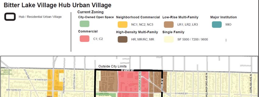
f. What is the current comprehensive plan designation of the site?
The Project is part of the Shoreline 145th Street Station Subarea Plan, which includes updates to the
Comprehensive Plan and development code. Per the Seattle Comprehensive Pan 2035, the site is
designated Single Family Residential in the Haller Lake neighborhood and the Bitter Lake Hub Urban
Village (shown in Figure 5c).
g. If applicable, what is the current shoreline master program designation of the site?
Not applicable.
h. Has any part of the site been classified as a critical area by the city or county? If so, specify.
Shoreline Municipal Code critical areas (SMC 20.80) include geologic hazards, fish and wildlife habitat,
wetlands, and flood hazards. Plans should be reviewed for the presence of slopes meeting the criteria for
landslide hazard areas pursuant to SMC 20.80.220.B. If present, landslide hazard areas are subject to
SMC 20.80.
Seattle Municipal Code 25.09 defines similar categories of environmentally critical resource areas. Steep
slope erosion hazard areas (29.05.012.A.3.b.5) have slopes with an incline of 40 percent or more within a
18 SEPA Environmental Checklist (WAC 197-11-960)
FES0414200816PDX145th Street Multimodal Corridor Project
vertical elevation change of at least 10 feet. “Steep slope environmental critical areas” from Seattle
GeoData are shown in Figure 6.
Figure 6. Steep Slopes within Project Area
Construction on the Seattle side will remain within the existing roadway surface and not touch the steep
slope critical areas shown in Figure 6. A reconnaissance survey indicates these steep slope critical areas
appear to be related to humanmade cuts. In addition, there are no mapped landslide prone areas and no
other critical area categories mapped within the project area.
i. Approximately how many people would reside or work in the completed project?
Not applicable.
j. Approximately how many people would the completed project displace?
See discussion in question 9a.
k. Proposed measures to avoid or reduce displacement impacts, if any:
See discussion in question 9a.
l. Proposed measures to ensure the proposal is compatible with existing and projected land
uses and plans, if any:
The Project implements the Shoreline 145th Street Station Subarea Plan and Seattle 145th Street Station
Area Planning by improving the 145th Street corridor to support multiple modes of transportation and is
more supportive of the land use plan for high density transit-supportive uses nearest the light rail station
at 145th Street and I-5.
m. Proposed measures to reduce or control impacts to agricultural and forest lands of long-term
commercial significance, if any:
Not applicable.
9. Housing
a. Approximately how many units would be provided, if any? Indicate whether high, middle, or
low-income housing.
This Project does not involve the construction of new housing units, but the up-zoning of the parcels
adjacent to 145th Street will result in a net increase of residential units. Three MUR areas were
established in the Shoreline side of the Project area between Meridian Ave N and I-5: MUR-35’, MUR-45’,
and MUR-70’ (the difference being the allowed height).
The number of high, middle and low-income housing units is not known at this time, but the City of
Shoreline updated the development code (SMC 20.40.235) to include new opportunities for affordable
housing in the 145th Street Station Subarea Plan. The 145th Street Multimodal Corridor Project Land Use
Review (Jacobs, 2020) states, “within zones MUR-45’ and MUR-70’ it is mandatory that a portion of the
housing provided be affordable and within MUR-35’ it is voluntary. To meet the affordable housing
SEPA Environmental Checklist (WAC 197-11-960) 19
FES0414200816PDX145th Street Multimodal Corridor Project
requirements, there are incentives and requirements to build affordable housing units within
developments or pay into a local housing trust fund to support development of affordable housing
options.”
On the Seattle side of the Project, there would be no new housing units constructed, but the proposed up-
zoning in the Mandatory Housing Affordability Zone may result in a net increase of residential units.
The off-corridor bicycle network will not impact housing or land uses.
b. Approximately how many units, if any, would be eliminated? Indicate whether high,
middle, or low-income housing.
The proposed Project would result in the partial or full acquisition of 51 parcels in the City of Shoreline of
which 19 property acquisitions are anticipated to require the displacement of 22 residential (11 owner
occupants and 11 tenant occupants), 9 nonresidential (7 landlords and 2 nonresidential businesses) and
1 personal property only. (Relocation Plan, Jacobs, 2019). Per the analysis done for the Project’s
Environmental Justice Report (Jacobs, 2020), the median household income in the study area is $62,113,
which places most households (including the impacted residential units) under the classification of
middle-income households.
Properties that would have been acquired and residents displaced by the Project are already being
acquired or displaced by developer acquisitions. The number of property acquisitions needed for the
Project continues to evolve as more properties are acquired by developers in the up-zoned areas.
c. Proposed measures to reduce or control housing impacts, if any:
A preliminary market analysis was conducted for the Project to determine if there is available housing in
the area to address both owner and renters who could be displaced by the Project. Based on a search of
the Northwest Multiple Listing Service (NWMLS) in March 2020, there are 40 active, single-family
residential listings with two to five bedrooms and one to three bathrooms on standard residential lots that
would be suitable for a displaced family’s needs. The listings are all within the City of Shoreline. A similar
search of the NWMLS was conducted for single-family residential rentals and there are 16 active rentals
in the area. As a result, it is anticipated that for those who wish to remain in the area, there are
opportunities in comparable housing.
10. Aesthetics
a. What is the tallest height of any proposed structure(s), not including antennas; what is
the principal exterior building material(s) proposed?
The tallest feature of the Project will be streetlights on the north side of the road. The streetlights may be
as tall as 40 feet.
There are no buildings proposed as part of the 145th Street Multimodal Corridor improvements or off-
corridor bicycle network. The design includes the construction of new bus shelters by Metro measuring
approximately 7.5 feet tall.
b. What views in the immediate vicinity would be altered or obstructed?
The Project would not result in adverse visual impacts because the features of the reconstructed roadway
would be similar to the existing roadway. Views of street lights and traffic lights from residential units
would be retained in similar volume and form, but brand new. Some street lights will serve as utility poles,
consolidating the overall number of vertical features. New bus shelters will be added, changing the views
of the roadway. Most of the trees that would be removed are on the Shoreline side and on private
property. Street trees will be added to the public ROW. Some overhead lines would be buried on the
north side of the roadway from Meridian Avenue N to I-5, improving the viewshed.
20 SEPA Environmental Checklist (WAC 197-11-960)
FES0414200816PDXYou can also read