MARLIN B PLATFORM DRILLING ENVIRONMENT PLAN SUMMARY - Esso Australia Resources Pty Ltd ("Esso") Document Number: AUGO-PO-EMP-060
←
→
Page content transcription
If your browser does not render page correctly, please read the page content below
Esso Australia Resources Pty Ltd (“Esso”)

MARLIN B PLATFORM DRILLING ENVIRONMENT PLAN
                 SUMMARY

           Document Number: AUGO-PO-EMP-060
Marlin B Platform Drilling Environment Plan
                                                Summary

Table of Contents
1.   Introduction .............................................................................................................................. 2
     1.1.       Location of the Activity .................................................................................................. 2

2.   Description of the Activity....................................................................................................... 3
     2.1.       Activities that have the Potential to Impact the Environment ........................................ 4

3.   Description of the Receiving Environment ........................................................................... 5
     3.1.       Physical Environment .................................................................................................... 5
     3.2.       Biological Environment .................................................................................................. 5
     3.3.       Sites of Significance or Sensitivity in the Operating Areas and Surrounds................... 7
     3.4.       Socio-Economic Environment ....................................................................................... 7

4.   Environmental Risk and Impact Assessment and Management ........................................ 9
     4.1.       Operations Integrity Management System (OIMS) ....................................................... 9
     4.2.       Unplanned Events ....................................................................................................... 10
     4.3.       Hazards, Potential Impacts and Control Measures ..................................................... 11
     4.4.       Response Arrangements ............................................................................................. 15

5.   Implementation Strategy ....................................................................................................... 18
     5.1.       Ongoing Monitoring and Performance Review ........................................................... 18

6.   Consultation ........................................................................................................................... 19
     6.1.       Consultation Already Undertaken................................................................................ 20
     6.2.       Ongoing Consultation .................................................................................................. 23

7.   Contact Details ....................................................................................................................... 24

                                                                    i
Marlin B Platform Drilling Environment Plan
Summary
1. Introduction
This Environment Plan (EP) summary has been prepared in accordance with the requirements of
Regulation 11 (3) and (4) of the Offshore Petroleum and Greenhouse Gas Storage (Environment)
Regulations 2009. This document summarises the Marlin B Platform Drilling Environment Plan
(AUGO-PO-EMP-040), which was accepted by the National Offshore Petroleum Safety Environment
Management Authority (NOPSEMA) on 7 October 2014.
The Marlin B Platform Drilling EP covers the drilling and completion activities for the Marlin B Platform
Drilling Program. These activities consist of the drilling and completion of five wells, one oil well and
four gas producing wells, in the Turrum field, known as the ‘base drilling program’. The wells will be
drilled from the Marlin B platform using International Sea Drilling Limited’s (ISDL) Minimum Area Self
Erecting (MASE) Rig 175, in Production Licence Area VIC/L03, approximately 42 km from the
Victorian coast.
A further eight expansion wells (oil and gas wells) may be drilled following the drilling and completion
of the base drilling program from the Marlin B platform. These expansion wells are also covered by
the Marlin B Platform Drilling EP.
Esso Australia Resources Pty Ltd (“Esso”) is the operator and a titleholder of the abovementioned
production licences and licenced petroleum pipelines. ExxonMobil Australia is the holding company
for the Esso and Mobil companies in Australia.
1.1. Location of the Activity
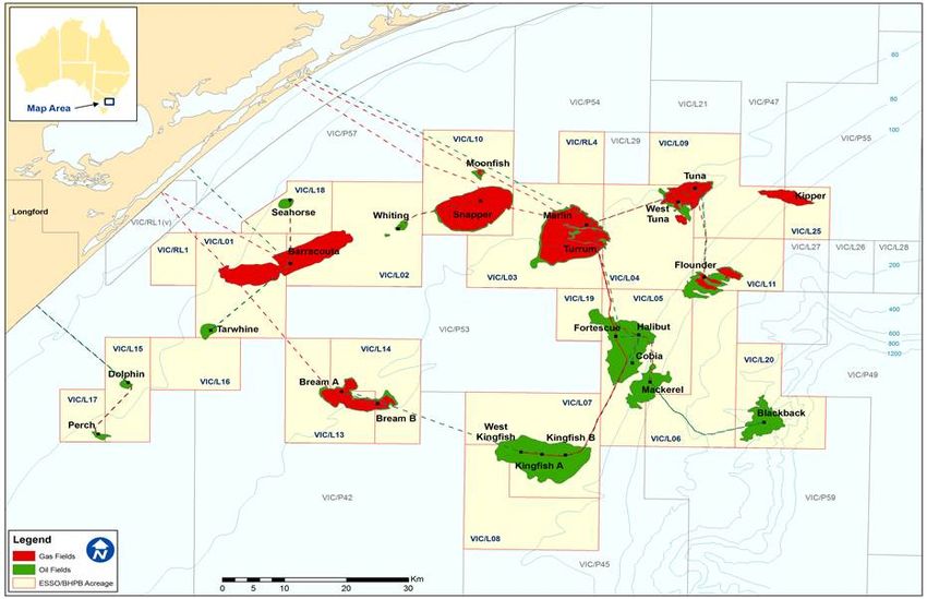
The Marlin B platform is located within the Gippsland basin, approximately 42 km off the Victorian
coast in Bass Strait (see Figure 1). The Marlin B platform is situated in a water depth of 59 metres
mean sea level (MSL).
The coordinates for the Marlin B platform are provided below:
38° 13' 46" South Latitude
148° 13' 16" East Longitude
The Turrum field underlies the Marlin B platform in Production Licence VIC/L03.
Marlin B Platform
Figure 1 Esso production facilities in Bass Strait
2Marlin B Platform Drilling Environment Plan
Summary
2. Description of the Activity
The Marlin B Platform Drilling Program includes the drilling and completion of five wells (one oil
producing well and four gas producing wells) in the Turrum field. The wells will be drilled from the
Marlin B platform (Figure 2) using ISDL MASE Rig 175 (Figure 3). A further eight expansion wells (oil
and gas wells) may be drilled following the drilling and completion of the base drilling program.
The Marlin B Platform Drilling Program is planned to commence in the fourth quarter of 2014, with
drilling expected to continue through 2015. Potential for drilling expansion wells could extend the
program to the fourth quarter of 2017.
The general drilling procedure for the base program wells starts with the drilling of a surface hole from
the pre-installed conductor. The surface casing is then run and cemented in place. These operations
are conducted with a diverter in place. A surface-mounted blowout preventer is installed, and
production hole section is drilled. The production casing is then run and cemented in place
Completion tubing is then installed.
Drilling operations will be supported by a supply vessel. The supply vessel will provide drilling
equipment, casing, drill pipe and drilling fluids to the platform.
Figure 2 Marlin B Platform (left) connected to Marlin A Platform
Figure 3 ISDL MASE Rig 175 on a Bass Strait platform in 2008, 45˚ aerial view
3Marlin B Platform Drilling Environment Plan
Summary
2.1. Activities that have the Potential to Impact the Environment
Activities that have the potential to impact the environment from planned activities are divided into
four main groups and include:
Drilling Rig Operations and Presence
• Operational emissions (noise, lighting and air emissions).
Support Vessel Operations
• Vessel operations and movement.
Chemicals
• Chemical and hazardous substances storage and handling.
• Bulk transfer activities.
• Supply vessel transfers of packaged materials.
Drilling and Completions
• Surface hole drilling with water based mud (WBM).
• Displacement of drilling fluids and management of interface fluids during displacement from
WBM to non-aqueous drilling fluid (NADF).
• Production hole drilling with NADF.
• Cementing operations.
• Well bore clean up activities.
• Use and storage of radioactive sources.
• Crane operations and lifting activities.
The hazards associated with these activities were all assessed for their potential impact on the
environment and are outlined in Section 4.
4Marlin B Platform Drilling Environment Plan
Summary
3. Description of the Receiving Environment
This section describes the environment in the platform operating area (i.e. the immediate zone around
the platform) and the surrounding area (i.e. the area identified, through Oil Spill Trajectory Modelling,
as potentially being impacted by a loss of well control/well blowout event).
3.1. Physical Environment
The Marlin B platform is located in Commonwealth waters within the Gippsland basin, in Production
Licence VIC/L03, approximately 42 km off the Victorian coast in Bass Strait. Bass Strait is the region
of the continental shelf that separates mainland Australia from Tasmania. Bass Strait, including the
platform operating area and surrounds, is located in a relatively shallow area of the continental shelf
and has high winds and strong tidal currents. The area includes marine parks and reserves, as well
as listed endangered or vulnerable species.
Wind speeds are in the range of 10 to 30 km per hour, with maximum gusts reaching 100 km per
hour. The wind direction is predominately westerly during winter, westerly and easterly during spring
and autumn (when wind speeds are highest) and easterly during summer. Average offshore summer
air temperatures range from 13 to 21°C and average winter temperatures range from 9 to 14°C.
Temperatures in the subsurface waters of the operating area range from about 13°C in
August/September to 16°C in February/March. Surface temperatures can exceed 20°C at times in late
summer due to the warmer waters of the East Australia Current entering Bass Strait.
Currents around the platform location are tide and wind driven. Tidal movements predominantly have
a northeast–southwest orientation. Tidal flows come from the east and west during a rising (flood)
tide, and flow out to the east and west during a falling (ebb) tide.
The area around the platform is a high energy environment exposed to frequent storms and
significant wave heights. The bathymetry in the Gippsland Basin (Bass Strait, off mainland south-
eastern Victoria) is concave shaped, with a shallower rim on the eastern and western entrances to the
Strait and a deeper centre.
3.2. Biological Environment
The platform operating area and surrounds support a range of benthic (seabed) invertebrate fauna as
well as a variety of vertebrate species such as fish, birds, seals and whales, including listed,
endangered, and vulnerable species under the Environment Protection and Biodiversity Conservation
Act 1999 (EPBC Act). The platform operating area and surrounds also contain a number of marine
fauna that have high commercial value.
3.2.1. Species Listed Under the EPBC Act
3.2.1.1. Fish and Shellfish
It is estimated that there are over 500 species of fish found in the platform operating area and
surrounds, including a number of species of importance to commercial and recreational fisheries.
Four fish species potentially occurring within the surrounding area were listed as ‘threatened’ under
the EPBC Act; the Black Rockcod (Epinephelus daemelii), the Eastern Dwarf Galaxias (Galaxiella
pusilla), the Macquarie Perch (Macquaria australasica) and the Australian grayling (Prototroctes
maraena). No EPBC Act listed threatened species were found to occur within the operating area.
Pipefishes, seahorses and seadragons are generally associated with vegetation in sheltered to
moderately exposed reef areas at a range of depths from 0 to 50 m, depending on the species (Edgar
1997), but usually at depths of between 5 and 25 m. Given that these species normally inhabit
shallow reefs and kelp beds they are not likely to occur within the platform area itself but around
adjacent shorelines in the Gippsland basin.
3.2.1.2. Sharks and Rays
Three shark species potentially occurring within surrounding area were listed as ‘threatened’ under
the EPBC Act; the Grey Nurse Shark (east coast population) (Chacharias taurus), the Great White
5Marlin B Platform Drilling Environment Plan
Summary
Shark (Carcharodon carchari), and the Whale Shark (Rhincodon typus). Two of these species, the
Great White Shark and the Whale Shark, were also identified as potentially occuring within the
platform operating area.
Two other species of shark, shortfin mako (Isurus oxyrinchus) and porbeagle (Lamna nasus), are
listed as migratory under the EPBC Act with habitat likely to occur in the platform operating area.
There were no listed or threatened rays in the operating area or surrounds.
3.2.1.3. Reptiles
Three threatened species of turtle, the loggerhead turtle (Caretta caretta) (endangered and
migratory), the leatherback turtle (Dermochelys coriacea) (endangered and migratory) and the green
turtle (Chelonia mydas) (vulnerable and migratory) are listed as potentially having habitat in the
platform operating area. In addition to these species, the hawksbill turtle (Eretmochelys imbricata)
(vulnerable) is listed as threatened and potentially occurring in the surrounding area.
3.2.1.4. Birds
The Victorian coast and neighbouring islands provide feeding and nesting habitats for many coastal
and migratory bird species. Seabirds spend much of their lives at sea in search of prey and return for
a short time to breed and raise chicks.
Colonies of seabirds occur to the west of the operating area in Corner Inlet and on the islands around
Wilsons Promontory, to the east at the Skerries, Tullaberga Island and Gabo Island and to the south
on Curtis Island and the Hogan Island Group. Eastern Bass Strait is also a foraging area for at least
15 species of albatross, three species of petrel and one species of skua.
Ninety-four bird species listed under the EPBC Act, may occur, or are likely to occur, within the
platform operating area and surrounds. Of these bird species, 21 may occur, or are likely to occur,
within the platform operating area. Many birds periodically pass through the area on their way to or
from the Bass Strait islands and mainlands of Victoria, NSW and Tasmania.
3.2.1.5. Seals
Two seal species, the Australian fur seal (Arctocephalus pusillus doriferus) and the New Zealand fur
seal (Arctocephalus forsteri) are known to occur in the platform operating area. Both species are
listed under the EPBC Act, however they do not carry a threatened status under Commonwealth
legislation or Victorian State legislation. Seals are frequently seen throughout Esso’s Bass Strait oil
and gas platforms and are usually found resting and swimming in the vicinity of the platform
structures.
3.2.1.6. Cetaceans
Several cetacean species (whales, dolphins and porpoises) listed under the EPBC Act, may occur, or
are likely to occur, within the platform operating area and surrounds. This includes blue whales
(Balaenoptera musculus), southern right whales (Eubalaena australis), humpback whales (Megaptera
novaeangliae), bottle-nosed dolphins (Megaptera novaeangliae) and dusky dolphins
(Lagenorhynchus obscurus), all of which may occur, or are likely to occur, within the platform
operating area.
Whales are known, and observed, to play and display normal breaching, blowing, lobtailing and diving
behaviour around the platform and vessels, including with calves, before moving on again. Although
whales are known to migrate through the region during spring and autumn/early winter, the operating
platform area is not a recognised feeding, breeding or resting area for cetaceans.
3.2.2. Marine Environments
Offshore marine environments that occur within the surrounding area include:
• Open marine environment (also occurs within the platform operating area).
• Seabed (also occurs within the platform operating area).
• Subtidal rocky reefs.
6Marlin B Platform Drilling Environment Plan
Summary
• Estuaries.
Nearshore environments within the surrounding area include:
• Intertidal rocky shores.
• Intertidal, emergent, sub tidal aquatic vegetation.
• Sheltered intertidal flats and bare sediment (mudflats).
• Marshes.
• Mangroves.
• Sandy beaches and dunes.
• Cliffs/exposed rocky headlands.
• International, national, state, regional or coastal sites of significance or sensitivity.
3.3. Sites of Significance or Sensitivity in the Operating Areas
and Surrounds
There are no areas of high conservation significance present in the platform operating area itself.
There are sensitive habitats in the surrounding area, comprising of:
• International sites of significance including the Gippsland Lakes Ramsar Site; Corner Inlet
Ramsar Site and Croajingolong National Park and Biosphere Reserve (including Nadgee
Nature Reserve).
• National sites of significance including the Australian Whale Sanctuary; Beagle
Commonwealth Marine Reserve; East Gippsland Commonwealth Marine Reserve; Flinders
Commonwealth Marine Reserve; Jervis Commonwealth Marine Reserve; Ben Boyd National
Park; Cape Howe Marine National Park; Point Hicks Marine National Park; the Lakes National
Park and Gippsland Lakes Coastal Park; Ninety Mile Beach Marine National Park; Corner
Inlet Marine National Park; Wilsons Promontory Marine National Park, Wilson’s Promontory
Marine Park, Wilsons Promontory Marine Reserve and Wilsons Promontory National Park;
Kent Group National Park and Kent Group Marine Reserve.
• State (NSW) sites of significance including the Jervis Bay Marine Park; and Batemans Marine
Park including Montague Island Nature Reserve.
• State (Victorian) sites of significance including the Gabo Island Harbour Special Management
Area and Gabo Island Light Station Reserve; Mallacoota Inlet Special Management Area; The
Skerries Special Management Area; Beware Reef Marine Sanctuary; Cape Conran Coastal
Park; Corner Inlet and Nooramunga Marine and Coastal Parks; and Bass Strait Islands
Nature Reserves and Conservation Areas.
• State (Tasmanian) sites of significance including the Bass Strait Islands Nature Reserves and
Conservation Areas.
3.4. Socio-Economic Environment
3.4.1. Cultural Heritage
There are no World Heritage properties or National Heritage places in the platform operating area and
surrounds.
The Gunai-Kurnai people hold native title over much of onshore Gippsland, and 200 m of offshore sea
territory between Lakes Entrance and Marlo. There are no other native title areas within the platform
operating area and surrounds.
3.4.2. Shipwrecks
A search of the National Shipwrecks Database identified 194 shipwrecks within the surrounding area
(32 in NSW waters and 162 in Victorian waters) and none in the platform operating area.
7Marlin B Platform Drilling Environment Plan
Summary
3.4.3. Commercial Fishing
Various commercial fisheries are known to occur within the platform operating area and surrounds.
The main commercial Commonwealth fisheries within the surrounding area are the Southern and
Eastern Scalefish and Shark Fishery (SESSF); the Bass Strait Central Zone Scallop Fishery
(BSCZSF); and the Small Pelagic Fishery. Other Commonwealth fisheries operating within the
surrounding area include the Eastern Skipjack Tuna Fishery and the Eastern Tuna and Billfish
Fishery.
State administered fisheries operating within the broader region include Victorian and Tasmanian
Scallop Fisheries; Victorian, Tasmanian and NSW Abalone Fisheries; Victorian, Tasmanian and NSW
Rock Lobster Fisheries; Victorian Commercial Bay and Inlet Fisheries; Tasmanian Shellfish Fishery;
NSW Ocean Trawl Fishery; NSW Ocean Trap & Line Fishery; NSW Estuary General Fishery; NSW
Ocean Hauling Fishery; and the NSW Oyster Aquaculture. Other State fisheries include the NSW
Estuary Prawn Trawl Fishery, Tasmanian Scalefish Fishery, Tasmanian Commercial Dive Fishery,
and Tasmanian and Victorian Giant Crab Fisheries.
3.4.4. Recreational Fishing, Boating and Tourism
The Gippsland region is estimated to attract more than 7 million visitors annually. These visitors are
estimated to spend an estimated $1 billion in the region per annum, with flow-on expenditure
estimated at over $699 million per annum. There are more than 1,000 specialised tourism businesses
in Gippsland and more than 12,000 people estimated to be employed as a direct result of tourism in
Gippsland.
Tourism and recreational activities offered by the coastal areas of central and eastern Gippsland
include; recreational fishing amongst the Nooramunga islands, on the Gippsland Lakes, along Ninety
Mile Beach, at Cape Conran Coastal Park and Croajingolong National Park and off the coast of
Mallacoota; swimming and surfing along the Gippsland coast; scuba diving and snorkelling in
Gippsland’s Marine and Coastal Parks; and walking and hiking in Gippsland’s National and Coastal
Parks.
Similar to the Gippsland region, the coastal areas of southern NSW also offer fishing, canoeing,
boating, diving and surfing activities in their bays and lakes, beaches and rivers. Popular activities
include walking along the Jervis Bay National and Marine Park and Killalea State Park; surfing,
swimming or fishing at ocean beaches; diving and snorkelling in the Bushrangers Bay Aquatic
Reserve; cycling, sailing, water skiing, rowing and fishing at Lake Illawarra; and exploring Montague
Island’s colony of Australian fur seals.
3.4.5. Commercial Shipping
Bass Strait is one of Australia’s busiest shipping areas with more than 3,000 vessels passing through
Bass Strait each year. Bass Strait is a transit route for shipping traffic connecting the eastern and
western ports of Australia. A shipping exclusion area (Area to Be Avoided) surrounds platforms in
Bass Strait, including the Marlin B platform.
3.4.6. Oil and Gas Industry
More than 4 billion barrels of liquids and 8 trillion cubic feet of gas has been produced in Bass Strait to
date, from offshore production facilities (platforms, monotowers and subsea completions) and via a
pipeline network of over 600 km; and various fields under exploration or development. There are 26
petroleum production licences held by various titleholders in Bass Strait.
8Marlin B Platform Drilling Environment Plan
Summary
4. Environmental Risk and Impact Assessment and Management
An analysis of environmental hazards and risks has been conducted for the Marlin B Platform Drilling
Program. Its purpose was to:
• Identify and assess potential hazards to the environment during the drilling program.
• Undertake a scenario-based risk assessment.
• Identify and rank hazards and determine appropriate risk reduction measures.
Esso identified and assessed the environmental risks associated with the drilling program and
identified controls for each risk to reduce the risks to the environment to As Low As Reasonably
Practicable (ALARP) and acceptable levels. Workshop participants were chosen based on their
familiarity with, knowledge of, and expertise in Esso’s operations at the Marlin B location. The
approach and methodology used during the ERA process was consistent with AS/NZS ISO 31000.
Environmental impacts and risks for planned activities that have the potential to impact the
environment (see Section 2.1) and for unplanned spill scenarios (see Section 4.2) were evaluated first
by determining the consequence severity, and estimating the probability or likelihood that the
consequences could occur.
• Consequence severity: There are four consequence categories (I through IV, with I being the
highest consequence level). The consequence categories consider environmental effects (in
terms of duration, size/scale, intensity) and sensitivity (in terms of irreplaceability, vulnerability
and influence).
• Probability: There are five probability categories (A through E, with A being the most likely
level). The probability categories consider the probability for each failure, event or condition
necessary to produce the consequences, given the implementation of controls that prevent
and mitigate the risk.
The combination of consequence severity and probability of occurrence determines the position on
the Esso Risk Matrix. The Esso Risk Matrix is divided into four categories, with Category 1 being the
highest risk category and Category 4, the lowest. A risk could have a low consequence severity and
high probability of occurrence, and result in the same risk ranking as a risk with a high consequence
severity and low probability of occurrence. Environmental risks described in this EP were assessed as
Category 2, 3 and 4 risks.
Esso then determined whether risks were reduced to ALARP by combining an understanding of the
nature and cause of the risk to be avoided and the cost involved in avoiding or mitigating the risk (in
terms of increased impact on personal safety and/or the environment, increased time, effort or
financial cost). A risk is considered to be reduced to ALARP if there are no additional reasonably
practicable measures available to further reduce the risk; or there are no reasonably practicable
alternatives to the activity; or the ‘cost’ of implementing further measures is grossly disproportionate to
the reduction in risk.
Esso then determined whether risks were reduced to acceptable levels by inspecting the final
category of environmental risk and comparing the management of the risk with internal and external
standards and stakeholder feedback. The risk is considered to be reduced to acceptable levels if the
level of residual environmental risk associated with the activity was either Category 2, 3 or 4; and the
activity is commonplace in current offshore practice (i.e. benchmarked), is compliant with current
industry/ExxonMobil Australia policy and standards, and Australian legislation; and any valid claims or
objections to the risk from relevant persons or stakeholders, are considered.
4.1. Operations Integrity Management System (OIMS)
The drilling program will be managed in accordance with ExxonMobil’s Operations Integrity
Management System (OIMS) and IDSL’s Health, Safety and Environment Management System
(HSEMS).
9Marlin B Platform Drilling Environment Plan
Summary
The OIMS Framework establishes expectations for addressing risks inherent in the business and
ensuring hazards are safely controlled. All OIMS management systems contribute to the effective
management of the identified environmental risks and impacts in the Marlin B Platform Drilling EP.
OIMS Systems that have been referenced as controls in Table 1 are:
• OIMS System 5-2 (Personnel Training) ensures that personnel are trained in the knowledge
and skills necessary to meet the requirements of their specific positions and roles.
• OIMS System 6-3 (Well Management) provides the structure for wellwork planning and
operations, as well as ongoing well integrity activities.
• OIMS System 6-6 (Facility Integrity Management) ensures that the operations integrity of all
Esso-owned or controlled critical equipment is maintained over the complete life cycle of the
equipment without significant failures that would (1) result in uncontrolled emissions, fires,
explosions, or incidents that might pose serious danger to people, the environment, or assets;
or (2) significantly impact equipment availability and reliability.
• OIMS System 8-1 (Contractor Selection and Management) provides a systematic approach
for the management of interfaces with third-party suppliers of services (i.e., contractors) to
achieve continuous improvement in contractor operations integrity performance. This System
covers requirements for interfaces for monitoring, evaluation, and feedback to the contractor.
• OIMS System 10-2 (Emergency Preparedness and Response) ensures that Esso establishes
effective emergency preparedness and response, and provides well maintained equipment
and trained personnel to manage incidents. Emergency situations include those incidents that
impact safety, security, health, and the environment.
4.2. Unplanned Events
Consideration was also given to unplanned events which, although unlikely to occur, could lead to
impacts to the environment. Based upon the proposed activities, an assessment of all potential spill
scenarios (for chemicals, drilling fluids and hydrocarbons) which could occur from drilling operations
was conducted as part of the Environmental Risk Assessment (ERA). The ERA identified the
following worst-case spill scenarios:
• Vessel collision with the platform or another vessel.
• Encountering shallow gas resulting in a gas and condensate release.
• Loss of well control/well blowout event resulting in an oil and/or condensate release.
The loss of well control/well blowout event was carried forward to Oil Spill Trajectory Modelling and
determined the Zone of Potential Impact to the environment in the unlikely occurrence of an
unplanned event.
The Zone of Potential Impact encompasses the platform operating area (i.e. the immediate zone
around the platform) and the surrounding area (i.e. the area identified, through Oil Spill Trajectory
Modelling, as potentially being impacted by a loss of well control/well blowout event, and described in
Section 3).
10Marlin B Platform Drilling Environment Plan
Summary
4.3. Hazards, Potential Impacts and Control Measures
A summary of the environmental hazards, potential impacts and controls is provided in Table 1.
The Esso Risk Matrix is divided into four risk categories. The significance of each Risk Category is as
follows:
Category 1: A higher risk where specific controls should be established in the short term and
should, when possible, be reduced to a Category 2 risk or below. Continued operation
requires annual review and approval by the Production Manager or equivalent.
Category 2: A medium risk that should be reduced unless it is not "reasonably practicable" to
do so.
Category 3: A medium risk that should be reduced if "lower cost" options exist to do so.
Note: "Lower cost" denotes follow-up work that can be completed without a) allocating
extensive engineering, technical, and operations manpower or b) the need for unit shutdowns
or activities which may introduce other risks or use resources that may be more appropriately
used to address higher risk category items.
Category 4: A lower risk that is expected to be effectively managed in base OIMS practices
and therefore typically requires "No Further Action." Risk mitigation measures that are
in place to manage the risk to Category 4 should be continued.
Environmental risks described in this Environment Plan have been assessed as Category 2, 3 and
Category 4 risks.
Table 1 Summary of Hazards, Potential Impacts and Control Measures
Risk
Hazard Potential Impact Control Measures Ranking
Drilling rig operations and presence
Physical Behavioural change, OIMS System 8-1 (Evaluating, Selecting and Monitoring Third 4
presence – impairment to movement Parties) ensures vessel contractors maintain vessel thrusters.
Noise patterns of seabirds, OIMS System 8-1 (Evaluating, Selecting and Monitoring Third
(combined hearing impairment to Parties) ensures that vessel contractors maintain a 300 m standoff
assessment marine fauna, increased distance from cetaceans (where possible and safe to do so as they
with noise from stress in marine fauna move into and out of the 500 m exclusion zone).
support vessel)
Physical Disruption to migratory None – the presence of the rig was assessed as not significant to 4
presence – patterns of seabirds and warrant controls.
Lighting movement patterns of
(combined marine fauna.
assessment
with noise from
support vessel)
Emissions to Contribution to greenhouse Preventive maintenance programs in place for fuel combustion 4
atmosphere gases. equipment and energy usage equipment to maximise efficiency.
from fuel
combustion
equipment
operation.
Support vessel operations
Discharge of Localised and temporary OIMS System 8-1 (Evaluating, Selecting and Monitoring Third 4
vessel deck reduction in water quality Parties) ensures vessel contractors have scupper plugs fitted to
drainage leading to potential impact overboard drains.
on marine organisms.
11Marlin B Platform Drilling Environment Plan
Summary
Risk
Hazard Potential Impact Control Measures Ranking
Discharge of Localised and temporary OIMS System 8-1 (Evaluating, Selecting and Monitoring Third 4
vessel oily reduction in water quality Parties) ensures vessel contractors treat bilge to an oil-in-water
water (bilge) leading to potential impact concentration of 15ppm prior to discharge.
on marine organisms. OIMS System 8-1 (Evaluating, Selecting and Monitoring Third
Parties) ensures vessel contractors have a MARPOL-compliant
certified oily water separator system.
Sewage Sewage waste will be OIMS System 8-1 (Evaluating, Selecting and Monitoring Third 4
discharge readily dispersed and Parties) ensures vessel contractors treat sewage through a
from vessels degraded with little or no MARPOL-compliant certified sewage treatment system prior to
impact expected. discharge.
Disposal of Food waste will be readily OIMS System 8-1 (Evaluating, Selecting and Monitoring Third 4
food wastes degraded and dispersed, Parties) ensures vessel contractors macerate putrescible waste
from vessels with little or no impact (Marlin B Platform Drilling Environment Plan
Summary
Risk
Hazard Potential Impact Control Measures Ranking
Uncontrolled Localised and temporary Permit required for cement, barite, other powders, and NADF bulk 4
release of reduction in water quality transfer activities.
chemicals and leading to potential impact Bulk transfer of cement, barite, other powders, NADF and liquid
cement, non on marine organisms within chemicals only occur during suitable weather and sea states
aqueous drilling the operating area.
Hoses used for cement, barite, other powders, NADF and liquid
fluid, brine, chemicals are inspected prior to transfer
barite, and
bentonite Hoses used for cement, barite, other powders, NADF and liquid
chemicals are pressure tested before transfers to check for leaks or
during bulk
transfer hose failures
operations. Hoses used for NADF and liquid chemicals are fitted with dry break
couplings.
Hoses and dry break couplings are changed out regularly and
equipment used for the transfers are subjected to their own
equipment strategy for inspection and maintenance.
OIMS System 10-2 (Emergency Preparedness and Response)
ensures effective emergency preparedness and response plans are
in place, which provide for well-maintained equipment and trained
personnel.
OIMS System 8-1 (Evaluating, Selecting and Monitoring Third
Parties) ensures vessel contractors have a SOPEP in place.
Unplanned Localised and temporary OIMS System 6-6 (Facility Integrity Management) ensures cranes 4
release of reduction in water quality and lifting gear are appropriately maintained.
chemicals leading to potential impact Licenced ISDL crane operators
during supply on marine organisms within Use of D-220 Checklist for certification strut and winch line
vessel transfers the operating area.
inspections.
of packaged
chemicals
Drilling and completions
Discharge of Localised and temporary Use of low impact constituents to make up Water Based Mud. 4
drill cuttings reduction in water quality
(Water Based leading to potential impact
Mud adhered) on marine organisms within
and Water the operating area.
Based Mud. Local smothering of benthic
organisms within the
operating area.
Discharge of Localised and temporary Permit required for mud tank cleaning and overboard discharge. 4
mud tank reduction in water quality Use of low impact constituents to make up all drilling fluids and use
washings and leading to potential impact of low impact chemicals for tank washing.
interface fluids. on marine organisms within Transfer out as much of the tank residue before starting washing
the operating area.
procedure.
Washings and interface fluids are evaluated to confirm oil in water
concentration is less than 10% by volume before discharging.
Discharge of Increased water turbidity, Cuttings processing system and NADF recovery system is used to 4
Non Aqueous toxicity to marine organisms reduce NADF ROC toMarlin B Platform Drilling Environment Plan
Summary
Risk
Hazard Potential Impact Control Measures Ranking
Use and Localised change in Use of certified sub-contractors. 4
storage of radiation leading to Radioactive sources are stored and transported in certified storage
radioactive potential impact on marine containers.
sources organisms.
Crane A dropped object overboard OIMS System 6-6 (Facility Integrity Management) ensures cranes 4
operations and could fall on live equipment and lifting gear are appropriately maintained.
lifting activities or piping releasing Licenced ISDL crane operators.
hydrocarbons causing Use of D-220 Crane Operators Checklist for certification strut and
localised and temporary
winch line inspections.
change in water quality.
OIMS System 10-2 (Emergency Preparedness and Response)
ensures effective emergency preparedness and response plans are
in place, which provide for well-maintained equipment and trained
personnel.
OIMS System 6-6 (Facility Integrity Management) ensures oil spill
equipment is appropriately maintained.
Unplanned events
Vessel collision Localised reduction in water OIMS System 8-1 (Evaluating, Selecting and Monitoring Third 4
(with platform quality leading to potential Parties) ensures vessel contractors have trained and qualified
or another impact on marine Vessel Masters.
vessel) - organisms. OIMS System 8-1 (Evaluating, Selecting and Monitoring Third
Unplanned Parties) ensures vessel contractors have a SOPEP in place.
release of OIMS System 10-2 (Emergency Preparedness and Response)
chemical or ensures effective emergency preparedness and response plans are
diesel
in place, which provide for well-maintained equipment and trained
personnel.
OIMS System 6-6 (Facility Integrity Management) ensures oil spill
equipment is appropriately maintained.
Encountering Contribution to greenhouse A pilot hole will be drilled on the first well. 4
shallow gas gas emissions and potential A diverter is installed to prevent broaching on surface hole sections.
resulting in a localised impact to marine
methane organisms. Diverter exercises are conducted.
gas/condensate Diverter is function tested during the diverter exercise.
release. Shallow gas procedures are in place to respond to a shallow gas
event.
14Marlin B Platform Drilling Environment Plan
Summary
Risk
Hazard Potential Impact Control Measures Ranking
Loss of well Oil Spill Trajectory Well design incorporates the Barrier Philosophy. 2
control while Modelling shows the Procedures to be used to regain well control, should they be
drilling, following potential impacts required, have been agreed between the rig operator (ISDL) and
resulting in a may occur in the most ExxonMobil.
release of severe loss of well
Well control equipment is maintained and tested.
hydrocarbon to control/well blowout event:
Use of D-180 Well control readiness checklist.
the marine • Surface oiling to
environment. shoreline in Victoria, Selection of competent drilling contractor.
east of Wilson’s Utilising personnel who are trained and competent in well control.
Promontory; southern Drilling fluid overbalance is maintained through use of correctly
NSW; or Bass Strait weighted wellbore fluids.
Islands. Continuous monitoring of pressure parameters during drilling.
Dissolved/entrained oil
Pressure testing of physical barriers.
in nearshore waters.
Drill crew is trained in emergency well control procedures.
• Change in water
quality leading to Shut in any nearby flowing wells, if determined necessary by the
potential impact on anti-collision study plots, which incorporate relevant defined
seabirds, shorebirds, ellipses of uncertainty (EOU) and conductor positions.
marine mammals, OIMS System 10-2 (Emergency Preparedness and Response)
reptiles, fish and other ensures effective emergency preparedness and response plans are
marine organisms. in place, which provide for well-maintained equipment and trained
• Taint (off-flavour) of personnel.
seafood harvested OIMS System 6-6 (Facility Integrity Management) ensures oil spill
from areas severely equipment is appropriately maintained.
affected by a spill.
• Coastal waters of
declared native title
areas or shipwreck
sites exposed to oil.
• Exclusion of fishing,
shipping, boating,
tourism or oil and gas
activity from spill-
affected areas.
4.4. Response Arrangements
In the highly unlikely event of an unplanned loss of containment, the Oil Pollution Emergency Plan
(OPEP) outlines the response arrangements that can be undertaken, including:
• Source control.
• Monitoring and natural degradation.
• Dispersants.
• Protection and deflection.
• Containment and recovery.
• Shoreline clean-up.
• Setting exclusion zones.
Response arrangements will be utilised according to the size and type of spill, environmental and
cultural sensitivities, prevailing weather conditions, access constraints and available resources. A Net
Environmental Benefit Analysis (NEBA) is applied to consider the advantages and disadvantages of
various oil spill response options, which is completed in consultation with relevant government
departments and agencies.
The OPEP also outlines the resources (personnel and equipment) which may be utilised depending
on the size and nature of the spill, the lead organisations and responders, and the notification
requirements. The OPEP interfaces with the spill contingency plans developed by Australian Maritime
Safety Authority (AMSA) (National Plan), Victorian Government (VicPlan), NSW Government (NSW
Plan), Tasmanian Government (Tas Plan), Gippsland Ports (Gippsland Region Marine Pollution
Contingency Plan), and the Australian Marine Oil Spill Centre (AMOSC) (AMOSPlan).
15Marlin B Platform Drilling Environment Plan
Summary
Esso maintains oil spill response equipment stockpiles at its facilities at Long Island Point (near
Hastings) and Barry Beach Marine Terminal (South Gippsland). In addition, Esso can call upon
equipment and trained personnel from AMOSC (Geelong), Victorian State Plan resources, Australian
National Plan for Maritime Environmental Emergencies (National Plan) resources (e.g. from AMSA),
or internationally through its membership to Oil Spill Response Limited (OSRL).
Esso has developed checklists for managing an unplanned loss of containment, which include
responding to the first sighting of oil and gathering spill information, implementing source control
measures, classifying response levels (Level 1, Level 2 or Level 3), implementing response action
plans/arrangements and reporting to statutory agencies. Esso manages incidents using the Incident
Command System, which is a system designed to provide a consistent organisation to respond to
emergency situations. Positions within the ICS are fixed and have specific functions, ensuring that all
responders know what to do and where they report in the organisation structure. A response to a spill
may also utilise members of the Esso Emergency Support Group (ESG) who provide strategic
support, and if the response level is elevated, ExxonMobil’s Regional Response Teams who have
experience in responding to emergencies internationally.
Waste generated through oil spill response operations will be managed using Esso’s Waste
Management Manual (WMM). Esso has a contract in place for the provision of waste management
services (including treatment, recycling and disposal) and is able to quickly mobilise a team of experts
anywhere in Australia. If oil spill response operations result in the generation of wastes outside of
Victoria, Esso will manage and dispose of these wastes using a spill-specific Waste Management
Plan.
Wildlife response will be managed through applicable wildlife response arrangements in each state. In
Victoria, wildlife response will be initiated under Victoria’s emergency management arrangements as
per the Emergency Management Act 1986 (Vic). The Wildlife Response Plan for Marine Pollution
Emergencies (which is a sub-plan to VicPlan) will also be implemented. In Tasmania, the WildPlan
will be implemented and in NSW, the Agriculture and Animal Services Functional Area Supporting
Plan and associated policies and procedures will be implemented.
The OPEP includes an Operational and Scientific Monitoring Program (OSMP), which is initiated in
the event of a spill. Esso has third party contracts in place for the provision of environmental
monitoring services.
Training and exercises are used to maintain Esso’s ability to implement an emergency response. Oil
spill response training is made available to specific Esso personnel required to undertake a role in oil
spill response. Elements of the OPEP, and associated oil spill response resources (equipment or
personnel), are exercised at least annually. Additional exercises are scheduled should there be a
significant change to response arrangements.
4.4.1. Spill Response Activities Potential Impacts and Risks
Spill response activities have the potential to incur impacts and risks to the environment, and these
are managed carefully with controls in place in the unlikely event a spill does occur. The potential
environmental impacts and risks associated with proposed response strategies include:
• Seabed disturbance from mobilising a relief well drilling rig or mechanical agitation,
• Exclusion of ocean and shoreline users due to implementation of spill exclusion zones,
• Exposure of in-water fauna to oil and/or dispersant from applying dispersant, or mechanical
agitation techniques,
• Shoreline impacts from spill response equipment and personnel mobilisation,
• Inappropriate waste disposal,
• Impacts to wildlife from inappropriate handling,
• Noise from vessels or aircraft,
• Vessel collision with marine fauna, and
• Additional spills (e.g. from spill response vessel collision, ROV collision or release, or an
unplanned release while manually cleaning up oil).
16Marlin B Platform Drilling Environment Plan
Summary
Esso has detailed performance outcomes and standards on controls that manage the above potential
impacts and risks to ensure spill response activities are managed to ALARP and acceptable levels
during an actual spill response.
17Marlin B Platform Drilling Environment Plan
Summary
5. Implementation Strategy
The implementation strategy detailed in the Marlin B Platform Drilling EP identifies OIMS systems,
practices and procedures that are used to ensure environmental impacts and risks of the activity are
reduced to ALARP and acceptable levels, and that environmental performance outcomes and
standards are met. The implementation strategy includes the following elements:
• Clear definition of personnel roles and responsibilities.
• Training, communications and awareness of environmental commitments.
• Performance measurement review and reporting, including regulatory reporting, incident
reporting and environmental performance review.
• Environmental monitoring, auditing, assessments, investigations and inspections.
• Management of third party contractor services.
• Emergency and oil spill preparedness and response.
• Ongoing consultation.
5.1. Ongoing Monitoring and Performance Review
Esso will undertake an annual compliance audit against the EP. The audit will contain a detailed
assessment of compliance with the environmental performance outcomes and standards and an
overview of the effectiveness of control measures (i.e. that impacts and risks are reduced to ALARP
and acceptable levels). Findings and recommendations of the audit will be documented and
communicated to the crew.
OIMS Assessments are also carried out to confirm that the ongoing monitoring and measurement
processes detailed in each of the OIMS systems are being carried out, environmental performance
outcomes and standards are being met, and environmental impacts and risks are reduced to ALARP
and managed to acceptable levels. OIMS Assessments are undertaken on a rotating basis (internal
and external assessment on each system every two years), and an OIMS review occurs annually to
confirm the status and effectiveness of each system.
Monitoring of environmental performance is undertaken on a regular basis through various forums
including monthly leadership meetings, twice-daily tool box meetings, and daily rig calls and morning
meetings.
Investigations into environmental incidents and non-conformances are conducted in accordance with
Esso’s Incident Management System (as detailed in OIMS System 9-1 Incident Management).
Notification, reporting and investigation of incidents:
• Ensures management, regulatory authorities and other appropriate personnel are notified of
all incidents and near misses on a timely basis;
• Enables the sharing of learnings throughout the organisation to continuously improve internal
health, safety and environment systems;
• Identifies corrective actions to prevent re-occurrence; and
• Enables the analysis and trending of incident data to ensure appropriate focus on emerging
issues.
In accordance with Regulation 17 (6) of the Offshore Petroleum and Greenhouse Gas Storage
(Environment) Regulations 2009, Esso will submit a proposed revision of the EP to NOPSEMA
before, or as soon as practicable after, a new or significantly increased environmental impact or risk
has been identified that is not provided for in the EP.
18Marlin B Platform Drilling Environment Plan
Summary
6. Consultation
Esso has undertaken consultation with all relevant stakeholders potentially affected by the Marlin B
Platform Drilling Program.
Stakeholders included:
• Commonwealth and State Victorian, NSW and Tasmanian government bodies and others that
provide direct advice or collaborate on plans in a spill response (e.g., emergency and oil spill
response agencies and providers, fishing management authorities, emergency services and
port authorities).
- Australian Marine Oil Spill Centre (AMOSC)
- Australian Maritime Safety Authority (AMSA)
- Asia-Pacific Applied Science Associates (APASA)
- Victorian Department of Transport Planning and Local Infrastructure (DTPLI)
- Victorian Department of State Development, Business and Innovation (DSDBI)
- Victorian Department of Environment and Primary Industries (DEPI)
- Transport for NSW
- Tasmanian Department of Primary Industries, Parks, Water and Environment (DPIPWE)
- Tasmanian Parks and Wildlife Service (PWS)
- Australian Fisheries Management Authority (AFMA)
- Commonwealth Fisheries Association (CFA)
- Commonwealth Department of the Environment (DoE)
- Environment Protection AuthorityVictoria (EPA Vic)
- Gippsland Ports
- Philip Island Nature Park
- Wildlife Victoria
- Gippsland Coastal Board
- State Emergency Service (SES)
- Victoria Police – Gippsland Water Police
- Cardno Lane Piper (environmental monitoring)
• Commercial and recreational fisheries; fishing industry groups, associations and co-
operatives;
- Seafood Industry Victoria (SIV)
- Tasmanian Seafood Industry Council (TSIC)
- Victorian Department of Environment and Primary Industries (DEPI) – Fisheries
- Corner Inlet Fisheries Habitat Association
- Eastern Victorian Sea Urchin Divers Association
- East Gippsland Estuarine Fishermen’s Association
- Lakes Entrance Fishermen’s Co-operative Limited (LEFCOL)
- Lakes Entrance Scallop Fishing Industry Association
- Port Franklin Fishermen’s Association
- South East Trawl Fishing Industry Association (SETFIA)
- Sustainable Shark Fishing Association
19Marlin B Platform Drilling Environment Plan
Summary
- Victorian Recreational Fishing (VRFish)
- Victorian Scallops Industry Association
- Victorian Bays and Inlets Fisheries Association
- Victorian Rock Lobster Association
- Victorian Fishery Association Resource Management
• Other relevant government bodies; State (Victorian) catchment management authorities;
native title holders;
- National Offshore Petroleum Titles Administrator (NOPTA)
- Department of Industry (DoI)
- East Gippsland Catchment Management Authority
- Gunai-Kurnai via Office of Aboriginal Affairs
• Other oil and gas industry operators in Bass Strait;
- Bass Oil Company Limited
- BHP Billiton Petroleum (Bass Strait) Pty Ltd
- Carnarvon Hibiscus Pty Ltd / 3D Oil
- Nexus Energy Ltd
- Oil Basins Limited
- Origin Energy
- ROC Oil Limited
- Santos
- Strategic Energy Limited
• Shire councils.
- East Gippsland Shire Council
- South Gippsland Shire Council
- Wellington Shire Council
6.1. Consultation Already Undertaken
A number of mechanisms to communicate with stakeholders were used to ensure stakeholders can
make an informed assessment of the possible consequences of the activity on their functions,
interests or activities. This included distribution of a fact sheet, an email update on the Bass Strait
Production EPs, and correspondence through questions/comments raised, and through the website
(www.exxonmobil.com.au/offshore).
Consultation with stakeholders who were expected to provide direct advice or collaborate on plans in
oil spill response included workshops and meetings/phone discussions.
During the consultation period, Esso received queries and feedback from twelve stakeholders
regarding the drilling activity, of which four presented valid claims and/or objections and these have
been summarised in Table 3. One related to noise (No. 1), two to the discharge of drill cuttings (No. 2
and 3), and one concerning notification of other oil and gas operators in eastern Bass Strait in the
event of an oil spill (No. 4). All valid claims or objections from relevant persons/stakeholders to the
environmental risks identified in the EP were considered during the ERA process when determining
that potential impacts had been reduced to acceptable levels. All stakeholder feedback was
considered by Esso with follow up clarifications, objections and claims discussed at meetings or one-
on-one telephone conversations held between Esso and the stakeholders.
20Marlin B Platform Drilling Environment Plan
Summary
Table 3 Summary of Claims/Objections and Responses during Stakeholder Consultation
No. Stakeholder Claim/Objection Summary of Response
Noise
1 What is the noise baseline for drilling? The risk of noise on marine fauna was considered for the Marlin B Drilling
What are animal behaviors in program. A noise survey was conducted on Snapper platform in 2008 during
response to drilling noise, and how drilling with the same rig being used for Marlin B, and found that drilling noise
and over what period will this be levels were less than 100dB on the rig and most noise monitored was between
monitored? 85 to 94dB. By comparison, ambient ocean noise as a result of wind and wave
Does this include the cumulative activities have been assessed at 90 to 110 dB and guideline underwater noise
noise of all activities such as stand-by behaviour threshold levels for fish are reported to be over 150dB (RMS). We
vessels, supply vessels and drilling have not come across comparative thresholds for sharks; and the Marlin B
platform and surrounds is not a recognised breeding area for sharks.
combined?
Whales and dolphins are known to come up near the platforms and vessels,
including while drilling is taking place, and display their normal behaviours,
indicating that they are not adversely affected by noise. Observations of marine
fauna including whales, seals, and dolphins near Esso platforms and supply
vessels have occurred across more than 10 years.
We intend to use the regular supply vessels in Bass Strait for mobilising drilling
equipment, with no expected additional impacts from vessels.
Discharge of drill cuttings
2 How will Esso determine impact from The use of environmentally sound drilling fluids, combined with solids
discharge of drill cuttings are in removal/fluid recovery systems for NADF, reduces the environmental impact
accordance with the environmental associated with the discharge of drilling fluids. Modelling investigations showed
risk assessment, including potential that in Bass Strait conditions, drilling fluids disperse without any discernible
impacts to the food chain? environmental impacts.
In addition to modelling, there have been two key field studies (at Fortescue and
Snapper) undertaken in Gippsland Basin that confirm that impacts from drilling
cuttings and fluids are localized and short in duration, and are very unlikely to
have negative impacts on fishing food source or seafood at any widespread or
population level.
We measured the effect on the seabed of discharged drilling cuttings and fluids
at Fortescue before, during and after the 1998 drilling program, monitoring
various components (including seabed health and metals) using a sediment grab
sampler launched off a boat. In that study, it showed that the concentration of
metals (barium) would not have measurable effects on marine species. Impacts
to animals that live in sediment was limited to the area immediately around the
platform, and these fully recovered within four months of drilling.
The field study at Snapper in 2009 used an ROV to do a visual inspection around
the Snapper Platform, five months after drilling was completed, that showed a
large number of small burrows and mounds created by seabed organisms (such
as crustaceans and sea worms) within the cuttings. There were fish, sharks and
seals observed around the platform.
Given the localized effects of the discharge of drilling cuttings and fluids, there is
not expected to be any measurable effects on seafood or fish food sources.
We are implementing a visual ROV survey to assess the extent of cuttings
around the platform following drilling.
21You can also read