KWADUKUZA LOCAL MUNICIPALITY - THE KWAZULU-NATAL SCHEME SYSTEM
←
→
Page content transcription
If your browser does not render page correctly, please read the page content below
KWADUKUZA LOCAL MUNICIPALITY

                        THE KWAZULU-NATAL
                          SCHEME SYSTEM

                   Zoning Companion Document 1

                                      NOVEMBER 2016

Prepared for:
The Municipal Manager
KwaDukuza Local Municipality
14 Chief Albert Luthuli Street
KwaDukuza
4450

Tel: +27 032 437 5000

E-mail: municipalM@kwadukuza.gov.za
Contents

1.0         DEFINING LAND USE MANAGEMENT?......................................................................................... 3
2.0         WHY DO WE NEED TO MANAGE LAND? ..................................................................................... 3
3.0         WHAT IS LAND USE PLANNING? ................................................................................................... 4
4.0         WHO IS RESPONSIBLE FOR LAND USE PLANNING? ................................................................ 4
5.0         THE LEGAL FRAMEWORK ............................................................................................................... 5
6.0         MANAGING LAND THROUGH A SUITE OF PLANS .................................................................... 6
7.0         WHAT ARE THE ELEMENTS OF THE LAND USE SCHEME? ................................................. 11
7.1           STATEMENTS OF INTENT (SOI) .............................................................................................. 11
7.2           LAND USE DEFINITIONS............................................................................................................. 12
7.3           ZONES           12
7.4           THE SELECTION OF ZONES AND THE PREPARATION OF A SCHEME MAP................ 13
8.0         DEVELOPMENT PARAMETERS / SCHEME CONTROLS ........................................................ 14
9.0         SCHEME MAPS ................................................................................................................................... 16
10.0        MANAGEMENT OVERLAYS ............................................................................................................ 18
11.0        THE SCHEME DOCUMENT ............................................................................................................. 20
11.1          THE USE OF SCHEMES................................................................................................................. 20
12.0        SCHEME APPLICATION AND IMPLEMENTATION IN KWADUKUZA ................................ 21
12.1          LAND LOCATED OUTSIDE THE FORMER TOWN PLANNING SCHEMES ...................... 23
12.2          THE INCLUSION OF AREAS FROM KWAZULU IN THE SCHEME..................................... 23
12.3          TRADITIONAL COUNCIL LAND ................................................................................................ 24
13.0        PREPARING A CONSOLIDATED LAND USE MANAGEMENT SYSTEM (LUMS) SCHEME27
14.0        WHAT ARE THE BENEFITS OF A LAND USE SCHEME? ......................................................... 31
15.0        COMMUNITY PARTICIPATION AND THE IMPACT OF THE SCHEME ON INDIVIDUALS
            AND THE PUBLIC? ............................................................................................................................ 32
16.0        THE ROLE OF THE DEPARTMENT OF COOPERATIVE GOVERNANCE AND
            TRADITIONAL AFFAIRS IN ASSISTING ORDINARY CITIZENS AND THE NEW
            MUNICIPALITIES TO IMPLEMENT THE LAND USE MANAGEMENT SYSTEM?.............. 34
17.0        HOW IS THE DEPARTMENT OF CO-OPERATIVE GOVERNANCE AND TRADITIONAL
            AFFAIRS DOING THIS? .................................................................................................................... 34
180.0 CONCLUSION ...................................................................................................................................... 35
APPENDIX 1:                   A DETAILED LIST OF LAND USE ZONES ............................................................... 37
APPENDIX 2:                   COMPARISON OF NEW CONSOLIDATED SCHEME AND PREVIOUS ZONES39
APPENDIX 3:                   PLANNING APPLICATION CRITERIA FOR HOSPITALITY USES ................... 46
APPENDIX 4:                   REFERENCES ................................................................................................................. 56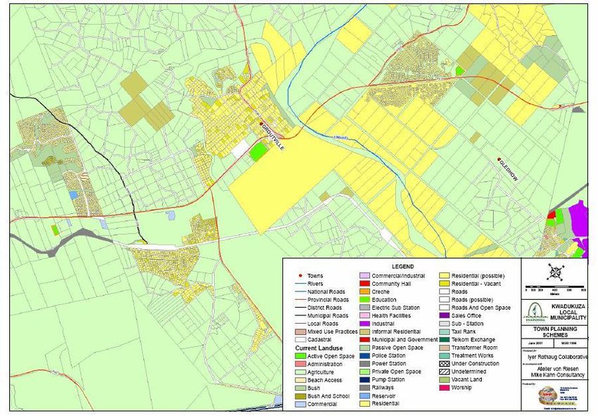
KWADUKUZA LOCAL MUNICIPALITY SCHEME COMPANION DOCUMENT 1 – ZONING
A LAND USE MANAGEMENT SYSTEM OVERVIEW - KWADUKUZA MUNICIPALITY
1.0 DEFINING LAND USE MANAGEMENT?
Land use management is the combination of all the tools and mechanisms used by a
municipality to manage the way in which land is used and developed, and includes: -
IDP/SDF – integrated development planning approach;
Vision Statement/Principles;
Land Use Framework Plans;
Land Use Schemes;
Other sectoral plans that influence or inform the Land Use Schemes;
By-laws;
Licensing;
Geographic Information System (GIS) and Mapping; and,
Rates and general property information.
The Scheme (sometimes referred to as a Zoning, Planning or Land Use Scheme) is only one
component of the Land Use Management System.
2.0 WHY DO WE NEED TO MANAGE LAND?
Land needs to be managed because it is a finite resource and requires a framework for
sustainable use. In terms of integrated development planning, there are additional reasons for
supporting land use management, which include: -
Orderly development, e.g. putting land uses in the right place;
Sustainable development, e.g. ensuring the continued use of land and resources for
future use;
To provide certainty and proactive planning, e.g. knowing what is allowed or what
may occur, so that developers and residents are able to make informed decisions;
To protect land assets and resources, e.g. planning for areas of environmental,
cultural and historical importance;
To provide efficient and planned services; and
To assist with health and safety, e.g. to be able to get emergency services and
vehicles to areas where they are needed.
Page 3 of 56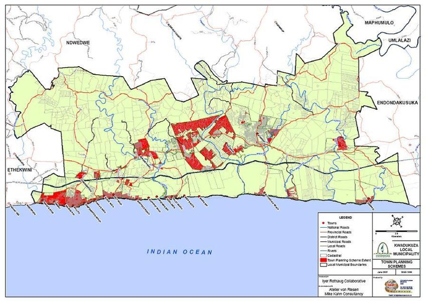
KWADUKUZA LOCAL MUNICIPALITY SCHEME COMPANION DOCUMENT 1 – ZONING
A LAND USE MANAGEMENT SYSTEM OVERVIEW - KWADUKUZA MUNICIPALITY
3.0 WHAT IS LAND USE PLANNING?
Land use planning aims to co-ordinate all the land uses and their relationship to each other in
order to create safe and liveable environments, e.g. “pleasant places to live, to work, to shop and
to play and recreate in”. This objective is achieved by providing rules and procedures for the
use and development of land and buildings. It makes use of a suite of standards or planning
regulations dealing with: -
The interrelationship between different land uses, e.g. the number of people required to
support a school, a clinic, a park, for cemeteries and land fill sites, a playground or a
shop;
The appropriate location for the grouping or separation of land uses, e.g. polluting
industries away from houses, or the placing of parks; shops and clinics near to
residential areas where people can get to them easily;
The relationship between land use and roads and other elements of the transportation
system;
The interrelationship of different types of plans and how they be integrated into or
aligned with each other; and.
Balancing the need between the use of land, and the need to protect natural resources
e.g. the sustainable use of agricultural land and conservation of environmentally
sensitive areas.
4.0 WHO IS RESPONSIBLE FOR LAND USE PLANNING?
All municipalities are required to prepare and approve Integrated Development Plans (IDPs)
and Spatial Development Frameworks which incorporate land use guidelines. These documents
and plans create a strategic framework for planning at the municipal level. All local
municipalities are responsible for preparing Schemes1 in consultation with local communities
and any other party affected by it. District Municipalities are not required to prepare Land Use
Schemes, however they are required to prepare Spatial Development Frameworks and a set of
land use management guidelines which assist with the alignment of Local Municipalities’ SDF
plans. In addition, District Municipalities can prepare Land Use Framework Plans to provide
clarity to the proposed spatial outcomes of the SDF and to provide generic policy guidelines for
planning and development issues that are common in the Local Municipalities within the
District.
1
Schemes are also referred to as Zoning, Planning or Land Use Schemes.
Page 4 of 56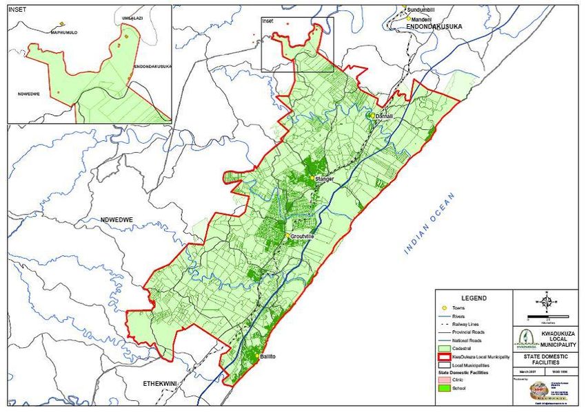
KWADUKUZA LOCAL MUNICIPALITY SCHEME COMPANION DOCUMENT 1 – ZONING
A LAND USE MANAGEMENT SYSTEM OVERVIEW - KWADUKUZA MUNICIPALITY
5.0 THE LEGAL FRAMEWORK
There are a number of existing laws and regulations that are used to manage and develop land.
In KwaZulu-Natal, the statutes used at present for the development and management of land
are:-
The national Spatial Planning and Land Use Management Act (Act No. 16 of 2013);
The Ingonyama Trust Amendment Act (Act No. 9 of 1997) for land falling under the
administration of Traditional Councils and managed by the Ingonyama Trust Board.
A Local Municipality must also be aware that other laws impact on land use management e.g.:-
The Sub-division of Agricultural Land Act (Act No. 70 of 1970);
The National Environmental Management Act (Act No of 107 of 1998);
NEMA: Biodiversity Act (Act No.10 of 2004);
NEMA: Integrated Coastal Management Act (Act No. 24 of 2008);
Local Government: Municipal Systems Act (Act No. 32 of 2000);
Local Government: - Municipal Demarcation Act (Act No. 27 of 1998);
Sea Shore Act (No. 21 of 1935) partially retained (coastal municipalities);
Admiralty Reserve (coastal municipalities);
National Water Act (Act No. 36 of 1998);
National Forest Act (Act No. 84 of 1984);
National Land Transport Transition Act (Act No. 22 of 2000);
Housing Code 2001; and,
Land Reform – Restitution of Land Rights Act (Act No.22 of 1994) as amended.
The national Spatial Planning and Land Use Management Act (Act No. 16 of 2013) (SPLUMA)
and the “to be” amended provincial PDA will be aligned so that the sections related to municipal
planning and development e.g. land use management are complementary and synchronized. The
Spatial Planning and Land Use Management Act (Act No. 16 of 2013) were enacted on 5 August
2013; the SPLUMA Regulations were gazetted and subsequently proclaimed on 23 April 2015;
and the date of effect of implementation of the SPLUMA, 2013 was 1 July 2015. The KwaDukuza
Municipality Spatial Planning and Land Use Management By-laws were adopted February 2016
by Council respectively and successively gazetted on 04 March 2016. Existing laws such as the
Page 5 of 56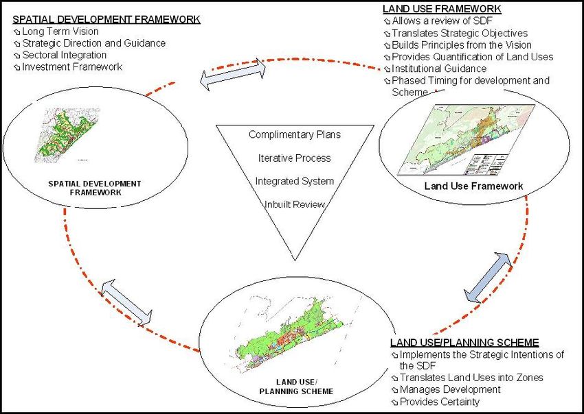
KWADUKUZA LOCAL MUNICIPALITY SCHEME                    COMPANION DOCUMENT 1 – ZONING
            A LAND USE MANAGEMENT SYSTEM OVERVIEW - KWADUKUZA MUNICIPALITY
Municipal Systems Act have also been considered in the preparation of the LUMS for
KwaDukuza.

6.0    MANAGING LAND THROUGH A SUITE OF PLANS
Land is managed through policy frameworks, legislation and regulations and developed through
a suite of interrelated plans and documents. The government requires that each District and
Local Municipality prepare an Integrated Development Plan (IDP) in terms of the Municipal
Systems Act (Act No. 32 of 2000).        IDP’s indicate, in broad terms, the intentions and
responsibilities of each municipality, and the actions that various government departments and
service providers need to take in order to meet the needs of people. An important part of any
IDP is the Spatial Development Framework, which is a plan that shows how the municipality
wants to develop its area in broad strategic terms. (See diagram below, which shows the
KwaDukuza SDF from 2013). The IDP is based on a strategic vision for the municipality.
KwaDukuza’s vision statement reads as follows:-

“By 2030, KwaDukuza shall be a vibrant city competing in the global village economically,
                      socially, politically and in a sustainable manner.”

A Spatial Development Framework is also required to outline a broad Land Use Management
System or a set of guidelines, which would outline all the actions a Local Municipality needs to
take, to manage the use and development of land. Land Use Schemes are a very important part
of a municipality’s Land Use Management System. The Integrated Development Plans and
Spatial Development Frameworks are representative of broad scale strategic planning.

They incorporate other sectoral plans e.g. Water, Housing, Transportation and Strategic
Environmental Assessments and provide the spatial translation of the vision statement of the
municipality.

                                         Page 6 of 56
KWADUKUZA LOCAL MUNICIPALITY SCHEME                        COMPANION DOCUMENT 1 – ZONING
                A LAND USE MANAGEMENT SYSTEM OVERVIEW - KWADUKUZA MUNICIPALITY
Map 1: The Spatial Development Framework (IDP)

Source: KwaDukuza Spatial Development Plan 2013

Land Use Framework Plans bridge the gap between the SDF’s and the Schemes by providing
additional detail and policy guidelines which assist the municipality with decision making
whilst a Scheme is being implemented. The preparation of a Land Use Framework provides an
opportunity to review and refine the methodology and content of the SDF and the Scheme. It is
possible that as SDF’s are reviewed and refined they will take on some of the positive attributes
of the Land Use Framework.

                                          Page 7 of 56
KWADUKUZA LOCAL MUNICIPALITY SCHEME                          COMPANION DOCUMENT 1 – ZONING
                  A LAND USE MANAGEMENT SYSTEM OVERVIEW - KWADUKUZA MUNICIPALITY
Figure 1: The Interrelation of the SDF, LUF and Scheme

Source: Atelier von Riesen

Land Use Schemes are more detailed than either the SDF or LUF since they show all the
intended land uses as Zones which conform to cadastral parcels. They set the rules and
procedures for land development which are presented a Scheme document. A Scheme plan
shows land uses on a map in the form of Zones. The municipality prepares a Scheme for all the
land under its jurisdiction with due regard to the interests of the public.

The scheme is a tool for managing development in accordance with the strategic intentions of
the IDP and the SDF, whilst promoting sustainability and quality of life. It consists of a plan and
document, which is approved in terms of relevant legislation.

                                           Page 8 of 56
KWADUKUZA LOCAL MUNICIPALITY SCHEME COMPANION DOCUMENT 1 – ZONING
A LAND USE MANAGEMENT SYSTEM OVERVIEW - KWADUKUZA MUNICIPALITY
The Scheme regulates land use and development through a number of mechanisms as outlined
below:-
It provides the grouping of complementary land uses together to create specific and
desirable urban and rural environments;
It deals with what uses are freely permitted, allowed through a consent procedure and
which uses are not permitted on each piece of land or site;
It guides or controls the shape, size and position of buildings;
It makes provision for additional architectural or urban design controls or guidelines;
and,
It indicates the parking requirements, loading, ingress and egress for certain land uses
with high on-site traffic volumes.
These requirements are necessary to avoid: -
Uncoordinated development which cannot be adequately serviced or managed;
The grouping of incompatible land uses together which create conflict and undesirable
environments; and,
The impact of development on each site, on adjoining or neighbouring sites, and the
surrounding area.
Collectively this complementary suite of plans – the SDF, the LUF and the Scheme constitute the
core components of the KwaZulu - Natal LUMS model as shown in the diagram below.
Page 9 of 56KWADUKUZA LOCAL MUNICIPALITY SCHEME COMPANION DOCUMENT 1 – ZONING
A LAND USE MANAGEMENT SYSTEM OVERVIEW - KWADUKUZA MUNICIPALITY
Figure 2: The Interrelationship of Plans
Source: Land Use Management Manual 2001
Page 10 of 56KWADUKUZA LOCAL MUNICIPALITY SCHEME COMPANION DOCUMENT 1 – ZONING
A LAND USE MANAGEMENT SYSTEM OVERVIEW - KWADUKUZA MUNICIPALITY
7.0 WHAT ARE THE ELEMENTS OF THE LAND USE SCHEME?
A Land Use Scheme is made up of a number of elements: -
Statements of Intent (SOI);
Land Use Definitions;
Land Use Zones;
Tables that indicate which land uses are permitted or prohibited for each Zone;
Development Controls for each of the Zones identified;
Land Use Procedures;
Use of Management Overlays or Management Plans that have been approved and are
aligned with or integrated within the Scheme; and,
Policies or Guidelines to assist with the management of newer concepts and special
developments.
Each of these elements is explained in more detail below.
7.1 STATEMENTS OF INTENT (SOI)
A Land Use Scheme is linked to the Integrated Development Plan (IDP) and Strategic
Development Framework Plan. The linkage is created by making use of a series of Statements
of Intent, which clarify how areas are to be developed. Statements of Intent can be prepared
for:
A whole Land Use Scheme in the form of a vision statement for the entire
municipality ( this would build directly on the vision of IDP);
Large Areas of a Land Use Scheme;
A street; or a small set of sites (a precinct);
Areas where architectural heritage or urban design issues need addressing; and,
A special project area.
Page 11 of 56KWADUKUZA LOCAL MUNICIPALITY SCHEME COMPANION DOCUMENT 1 – ZONING
A LAND USE MANAGEMENT SYSTEM OVERVIEW - KWADUKUZA MUNICIPALITY
7.2 LAND USE DEFINITIONS
A set of Land Use Definitions forms part of the Scheme document and outlines the meaning of
land use types and building descriptions found in the municipality. The provision of a list of
definitions with a clear descriptive explanation and classification of what is referred to is
necessary. It prevents misunderstandings or confusion in implementing the regulatory aspect
of the Scheme which is an adopted legal document.
7.3 ZONES
A zone is applied to a property and sets the property aside for a particular purpose/land use or
land uses usually used to separate different, incompatible land uses. Zones are applied to
registered parcels of land that have cadastral boundaries. It is also possible for one property to
have a split zoning. A zone may allow several different land uses as freely permitted, by consent
and may prohibit some land uses.
Zones are depicted on the Scheme map using different colours. Standardised colours are used
to facilitate common understanding especially when working across different municipalities.
This ensures consistency and legibility. For example, residential should usually be coloured
from yellow to brown depending on typology and density, commercial is usually blue and
industrial in various shades of purple.
Zones can be formulated with different degrees of detail, depending on the need or requirement
for simplicity or complexity. For small and /or simple settlements it appropriate to make use of
relatively few zones; whilst for large and more complex areas would require a greater range of
zones. The translation of the land uses identified by the Spatial Development Framework into a
Land Use Management Framework (LUMF) or other linking plan usually requires the expansion
of basic land uses into a series of broad “generic” land use areas or a sets of land uses e.g.
typologies. These land uses are designed to be appropriate for each particular municipality.
The formulation of the zones for a Scheme requires that these broad land use areas or
typologies are then translated into the zones with development controls or parameters.
Zones provided the mechanism which conveys potential development rights that are stipulated
in the Scheme. They form one of the bases for property valuations and property tax (rates)
calculation purposes. The minimum size of erven and potential density of development must
Page 12 of 56KWADUKUZA LOCAL MUNICIPALITY SCHEME COMPANION DOCUMENT 1 – ZONING
A LAND USE MANAGEMENT SYSTEM OVERVIEW - KWADUKUZA MUNICIPALITY
also take into account the type of engineering services required and available. They also
provide the present and future development potential of land and how it may change through
procedural applications e.g., special consent.
7.4 THE SELECTION OF ZONES AND THE PREPARATION OF A SCHEME MAP
The selection of appropriate Zones for a Scheme is dependent in the first instance of the
identification of accurate land uses but has to consider the strategic intentions of the SDF. Once
the zones have been identified then Statements of Intent (SoI) will be need to be prepared for
each spatial area. This also requires the consideration of available infrastructure versus what is
needed and the requirement for social facilities.
There are two major assumptions implicit in the above requirement, namely:-
1. That there is, usually, a layout or subdivision plan to which the zones can be
allocated. Such a plan indicates the road reserves and each cadastral land parcel;
and,
2. For the most part, each land parcel has a single zone ascribed to it.
Where there is no detailed layout plans, and where there are large sites which will be
subdivided into individual land parcels at a later stage there has been a tendency to address
these as “Special Zones” to which subsequent subdivision will be applied at a later stage, but
under specified conditions. This process of the detailing internal zones may require additional
work and the preparation of Precinct Plans and/or Spatial Development Plans. In cases of large
sites, it is possible that “split” zoning can be applied, such that two or more zoning types will
occur across a single site, approximately in accordance with the alignment of the zoning map. A
spilt zone can occur where there are significant environmental considerations which need to be
protected or managed on a site or set of sites e.g. where sites are located adjacent to rivers,
forests or wetlands.
In preparing the zoning map, it is necessary to answer a number of questions:
1. What is the design population of the area? What is the planning horizon prior to
future revision?
Page 13 of 56KWADUKUZA LOCAL MUNICIPALITY SCHEME COMPANION DOCUMENT 1 – ZONING
A LAND USE MANAGEMENT SYSTEM OVERVIEW - KWADUKUZA MUNICIPALITY
2. How many sets of zones should there be? This is dependent on the size, complexity
demands and development trends emerging in the area, as well as the role of the
municipality. In addition the Statements of Intent and the strategic intentions of the
SDF have to inform the choice of zones.
3. How much space should be allocated to each type of zone?
4. What social facilities are needed to support the population?
5. Where should the different sets of zones be located?
6. What types of land are suitable and appropriate for each type of zone?
7. What types of land uses are appropriate for the different zones?
8. What should be the physical relationships between various types of zones?
9. Where should the exact boundary lines of each zone run, bearing in mind that some
zones are separated by street pattern, some by the mid-block line, and some are
narrow bands of transition from one zone to the next?
10. Treatment and alignment with an “Urban Edge” or “Urban Growth Boundary” as
identified in the SDF?
11. Alignment with Act No. 70 of 70 in terms of obtaining permission for change of land
use of subdivision of land in agricultural areas?
8.0 DEVELOPMENT PARAMETERS / SCHEME CONTROLS
A municipality manages development within zones through a series of development
parameters, or Scheme controls relating to each zone that detail the requirements in respect of
buildings, built form and sub-divisional matters. Conventionally, development parameters set
out the maximum development permitted on a site. However, they may also be used to set out
the desirable or minimum development allowed.
The table on the next page illustrates the relevant parameters/scheme controls applicable to the
Residential Only Detached Zones found throughout the new consolidated KwaDukuza Scheme.
Page 14 of 56KWADUKUZA LOCAL MUNICIPALITY SCHEME COMPANION DOCUMENT 1 – ZONING
A LAND USE MANAGEMENT SYSTEM OVERVIEW - KWADUKUZA MUNICIPALITY
ZONE MINIMUM FAR COVERAG HEIGHT FRONT SIDE SETBACK (M) REAR FRONTAGE
SETBAC
ERF SIZE E (Storey SETBACK (M)
K (M)
(%) ) (M)
RODE 1000 NA 25% 2 7.5 m 2.5 m 2.5 m 18 m
1 4.5 m for MDH 4 m for Hatchet
and Cul de sacs
RODE 450 60 75% 2 3m 1.5 m 1.5 m 12 m
2
4 m for Hatchet
and Cul de sac
RODE 1,100 0.50 35% 2 7.5 m 2.5 m 2.5 m 18 m
3
3 m for Hatchet
and Cul de sac
RODE 250 1.50 75% 2 2m 2.0 m 2.0 m 10 m
4 3 for PG 4 m for Hatchet
and Cul de Sacs
RODE 900 1.00 50% 2 7.5 m 2.0 m with one boundary to nil to 2.0 m 18 m
5 allow for common wall where 4 m for Hatchet
dwelling adjoined and Cul de sac
RODE 900 0.35 30% 2 7.5 m 2.0 m 2.0 m 18 m
6 4m for Hatchet
and Cul de sac
RODE 350 0.8 70% 2 2.0 m 1.5 m with one boundary to nil to 1.5 m 4m
7 allow for common wall where
dwelling adjoined
To this end Schemes may contain rules relating to:-
Minimum/maximum lot sizes;
Height restrictions;
Floor Area Ratio (FAR) or the ratio of the total floor area of the building to the total area
of the subdivision on which the building is to be erected;
Coverage – the percentage of the plot that may be covered by a building or roofs;
Parking and vehicle loading requirements;
Setbacks – building lines;
Build-to-lines ;
Space around the buildings – side and rear spaces;
External appearance of buildings;
Urban design criteria; and,
Signage and advertising.
Page 15 of 56KWADUKUZA LOCAL MUNICIPALITY SCHEME COMPANION DOCUMENT 1 – ZONING
A LAND USE MANAGEMENT SYSTEM OVERVIEW - KWADUKUZA MUNICIPALITY
9.0 SCHEME MAPS
Scheme maps are part of the statutory Scheme document. They should be prepared at an
appropriate scale and show or contain at least the following:-
The area to which the Scheme shall apply;
The different Zones and Management Areas required to accommodate various
categories of buildings and land uses;
A suitable colour notation ;
Areas of land to be set aside for future development in the short and medium-term,
together with the proposed zoning;
Additional maps or overlays that may be necessary to reflect intensity of development
and/or other development controls
A reference numbering system that links all maps and overlays ;
Due to the amount of information a municipality may wish to show on its Scheme map it
is often necessary to separate the information out onto more than one map; and
The scheme map must contain the following: scale, north point, title block, the
municipality name and date of plan.
The following map is produced at a scale of 1: 50,000 and illustrates the Scheme for the entire
KwaDukuza Local Municipality. It is quite clear that the majority of the municipality is
identified for agricultural and environmental use with the detailed zoning in the urban centres
where former Town Planning Schemes were prepared to manage land use and development.
Page 16 of 56KWADUKUZA LOCAL MUNICIPALITY SCHEME COMPANION DOCUMENT 1 – ZONING
A LAND USE MANAGEMENT SYSTEM OVERVIEW - KWADUKUZA MUNICIPALITY
Map 2: The Scheme Plan for KwaDukuza
Source: KwaDukuza Scheme 2014
The map, below, provides an example of the scheme. It is drawn at a 1:5,000 scale and indicates
the detail zoning for a portion of the Scheme. This sheet is one of a total of fifteen (15) sheets
that cover the largely built-up area of the KwaDukuza Local Municipality. It clearly shows the
areas where environmental considerations have been included in the Scheme. Different zones
are delineated using a standard colour scheme proposed by the provincial Land Use
Management System.
Page 17 of 56KWADUKUZA LOCAL MUNICIPALITY SCHEME COMPANION DOCUMENT 1 – ZONING
A LAND USE MANAGEMENT SYSTEM OVERVIEW - KWADUKUZA MUNICIPALITY
Map 3: A Detailed Section of the Land Use Scheme
Source: KwaDukuza Scheme 2014
10.0 MANAGEMENT OVERLAYS
A Scheme provides the basic controls and regulations in respect of the nature and form of
development possible on any parcel of land or area. However, in certain circumstances there is a
need to augment these controls with additional considerations or more detailed plans. In these
instances Management Overlays may be used to further inform and regulate development i.e.
overlays are used in Schemes to facilitate the management of specific uses across and in
addition to several underlying zonings.
A Management Overlay applies to a defined area of land with a distinct set of intentions or
policy guidelines that influence and facilitate its development in a unique or specific manner
and may not have an exact cadastral boundary. Management Overlays may be shown spatially
using an overlay to the Scheme map.
A Management Overlay can be used:-
Page 18 of 56KWADUKUZA LOCAL MUNICIPALITY SCHEME COMPANION DOCUMENT 1 – ZONING
A LAND USE MANAGEMENT SYSTEM OVERVIEW - KWADUKUZA MUNICIPALITY
To elaborate the visions or policy statements for a particular area to differentiate them
from surrounding areas;
To provide general and/or specific guidelines for particular types of development;
To provide area specific schematic plans for particular areas or developments;
To demarcate an environmental or conservation management plan for an area; and,
To manage detailed area-specific development plans
A Management Overlay applies, in addition to the underlying zone or base zone of the
properties to which it relates, and may vary the development rules relating to a particular area
or land unit, or may set new development rules.
The provisions of a Management Overlay may not conflict the provisions applicable to the base
zone of the property concerned, and may set specific development rules for a particular area or
land unit.
If the provisions of a Management Overlay are different to, or in conflict with, the provisions of a
base zone, the more restrictive provisions shall apply. The provisions of a Management Overlay
may apply to a land unit or land units, identified within a specific area or to the Scheme as a
whole, as may be stipulated in the adoption of such a Management Overlay. The provisions of
more than one Management overlay may apply to an area.
There are essentially two kinds of Management Overlays:-
Overlays which refer to the area where a plan that has been formally adopted by the
Municipality applies. These may include Policy Plans, Housing Plans, Environmental
Plans, and Coastal Management Plans; and.
Informant Overlays which require practitioners/administrators to consider additional
criteria and to negotiate between different requirements, which usually require a level
of adjudication / trade-off. Informant Overlays include: Ecosystem Goods and Services
Maps, and Historical / Cultural Maps.
Page 19 of 56KWADUKUZA LOCAL MUNICIPALITY SCHEME COMPANION DOCUMENT 1 – ZONING
A LAND USE MANAGEMENT SYSTEM OVERVIEW - KWADUKUZA MUNICIPALITY
11.0 THE SCHEME DOCUMENT
Previous Town Planning Scheme documents were perceived as being difficult to interpret and
use by developers and members of the public. In the preparation of the new Land Use Schemes
thought has been given to the content and presentation of the information and its use linked to
GIS mapping. The Scheme document should include the following sections:-
An Introduction including definition, description of the Scheme area and date of
adoption;
A set of principles linked to the vision statement of the Integrated Development Plan
(IDP), and the Spatial Development Framework (SDF);
Statements of Intent for Broad Areas/Precincts within a municipality;
Zones, associated Statements of Intent and Intensity of Development;
Development Parameters and/or Scheme Controls;
Management Area Overlays and Plans;
Special Zones;
Definition of Terminology;
Policies and Guidelines;
Procedures;
Forms;
Monitoring and Review Requirements;
Reference to related legislation and procedures; and
Scheme Maps, Management Area Overlays and Management Plans, as appropriate.
11.1 THE USE OF SCHEMES
Land Use Schemes are used: -
To guide decisions regarding the land uses allowed on individual land parcels;
To indicate if there are special or unique characteristics or concerns that affect the
development of a site e.g. environmental or geological concerns and.
To provide guidelines regarding the form, shape and position of the buildings on a site.
Page 20 of 56KWADUKUZA LOCAL MUNICIPALITY SCHEME COMPANION DOCUMENT 1 – ZONING
A LAND USE MANAGEMENT SYSTEM OVERVIEW - KWADUKUZA MUNICIPALITY
In addition, the Land Use Scheme assists with: -
Managing the sub-division of land in certain areas;
Managing the use and development of land in all areas; and,
Making possible the identification of appropriate land to implement the intentions of the
IDP or special projects.
12.0 SCHEME APPLICATION AND IMPLEMENTATION IN KWADUKUZA
Prior to 2000, when the new municipalities were constituted by the Demarcation Board, land
and development in KwaDukuza had been managed via nine Town Planning Schemes and a
General Plan of similar land uses and management regulations for the former Mission Area of
Groutville.
The former nine Town Planning Schemes adopted in terms of the Natal Town Planning
Ordinance were:
Umhlali;
Zimbali;
Stanger (KwaDukuza);
Shaka’s Kraal;
Prince’s Grant;
Nkwazi;
Ballito;
Blythedale Beach; and,
Tinley Manor.
The following map identifies those areas which were covered by the nine Town Planning
Schemes (seen in red). The nine Town Planning Schemes were all fairly similar to each other in
that they follow the format of the original Provincial model Town Planning Scheme system.
The town of Zimbali, as a relatively new settlement has a slightly different format and was
considered an exception from the other eight.
Over time, each of the Schemes has evolved, and several variations emerged between towns
and the type of land use development allowed. These differences covered: -
Page 21 of 56KWADUKUZA LOCAL MUNICIPALITY SCHEME COMPANION DOCUMENT 1 – ZONING
A LAND USE MANAGEMENT SYSTEM OVERVIEW - KWADUKUZA MUNICIPALITY
Differences in respect of the General (or operational) Definitions;
Differences in the Land Use and Development Definitions;
Differences in respect of the Land Use Zones nomenclature;
Different development regulations pertaining to each of these zones; and
Variations in respect of policies and other clauses embedded in the Town Planning
Schemes.
Map 4: Map illustrating Areas with former Schemes
Source: KwaDukuza Scheme 2014
Notwithstanding the fact that many of the towns that comprise KwaDukuza Local Municipality
have been growing fast and exhibited many of the newer types of developments, several
aspects of the Town Planning Schemes reflect the older and earlier forms of zones and
development regulations. They do not include many of the newer forms of uses and zones that
have been emerging in the last decade. In this sense, the nine current Town Planning Schemes
Page 22 of 56KWADUKUZA LOCAL MUNICIPALITY SCHEME COMPANION DOCUMENT 1 – ZONING
A LAND USE MANAGEMENT SYSTEM OVERVIEW - KWADUKUZA MUNICIPALITY
(TPS’s) are lacking in terms of their strategic intent and were not able to respond sufficiently to
the challenges of contemporary forms of developments. This was reflected in the numerous
DFA Special Zones.
12.1 LAND LOCATED OUTSIDE THE FORMER TOWN PLANNING SCHEMES
It is also clear that the majority of the municipal area was not covered by a TP Scheme. The
majority of the land inside the KwaDukuza Municipal area has been surveyed and is held as
individual farms or property. The applicable legislation from a land management perspective is
the Spatial Planning and Land Use Management Act (Act No. 16 of 2013), although the KwaZulu-
Natal Planning and Development Act (Act No. of 2008) and the Town Planning Ordinance No.
27 of 1949 have not been repealed by SPLUMA, 2013. Most of this land is used for commercial
agricultural, forestry and settlement.
12.2 THE INCLUSION OF AREAS FROM KWAZULU IN THE SCHEME
Groutville is composed of former church owned land from the Umvoti Mission Area (also
referred to as Charlottedale). The Mission Reserve was established in by Reverend Grout of the
American Board Mission and was converted to trust Land (in terms of the 1936 Land Act).
Areas of trust land are interspersed with small areas of privately owned land which were sold to
individual land owners by the mission before the colonial government stopped the sale of
church land in the early nineteenth century. Groutville was managed by the former Department
of Development Aid located in Pretoria (Tshwane) until 1986 when the land was transferred to
Homeland Government of KwaZulu (Gazette number 10560 December 1986). A number of
upgrading projects have taken place in order to rationalize land ownership, upgrade tenure, and
to provide services and housing and these developments require appropriate zoning and
development parameters.
Prior to 2008, development and land use were managed in terms of a General Plan and utilized
KwaZulu Land Affairs Act (Act No. 11 of 1992) or national statutes e.g. the Upgrading of Land
Tenure Rights Act (Act No. 112 of 1991). However the introduction of a unitary provincial PDA
has allowed the area to be considered in the same manner as other parts of the municipality.
The new approach has provided the opportunity to make provision for new zones such as Rapid
Urban Management Area (RUMA) for upgrading informal housing and Urban Agriculture. The
following map identifies the land uses of the Groutville General Plan. These land uses will have
to be converted to zones for the implementation of the Scheme.
Page 23 of 56KWADUKUZA LOCAL MUNICIPALITY SCHEME COMPANION DOCUMENT 1 – ZONING
A LAND USE MANAGEMENT SYSTEM OVERVIEW - KWADUKUZA MUNICIPALITY
Map 5: The Land Use Map for Groutville
Source: KwaDukuza Scheme 2014
12.3 TRADITIONAL COUNCIL LAND
A small portion of the municipality, located on the North West border with Ndwedwe Local
Municipality is communally owned and administered by a Traditional Council. The Traditional
Governance Act, and the Ingonyama Trust Act are applicable in this area. Land is held in trust
and managed on a communal basis. Aside from some three types of State Owned Facilities e. g.
education, health and social welfare sites, there are no cadastral parcels in this area (see map
below). In terms of the Municipal Systems Act (No. of 2000), a set of land use guidelines has to
be developed for the entire municipality along with a ‘wall to wall’ Scheme which included
Traditional Council Areas. The new national Spatial Planning and Land Use Management Act
(Act No. 16 of 2013) has emphasized this requirement.
Page 24 of 56KWADUKUZA LOCAL MUNICIPALITY SCHEME COMPANION DOCUMENT 1 – ZONING
A LAND USE MANAGEMENT SYSTEM OVERVIEW - KWADUKUZA MUNICIPALITY
Map 6: Maps illustrating the Extension of the Scheme in Traditional Council Areas
Source: KwaDukuza Scheme 2014
In terms of current legislation, a Scheme must be prepared for the whole of the municipal area.
For some Local Municipalities this requires the integration and alignment of a number of
inherited Town Planning Schemes and their translation into a coherent unitary Land Use
Scheme that can be implemented across the whole municipality. The urban and rural areas
need be considered equally and this means the extension of land use management into areas
where none has previously been utilized. Preparing a wall-to-wall Scheme can be daunting and
it is now proposed that the municipalities undertake a phased approach dealing with priority
areas where there is evidence of development pressures.
Developing a coherent and equitable Scheme across a municipality places requires that planners
address the variation and specific needs of different areas. There is a need to develop policies to
contain urban sprawl, promote development that restructures the city form, guides the
appropriate growth of built up areas, balances natural and built form environments and
Page 25 of 56KWADUKUZA LOCAL MUNICIPALITY SCHEME COMPANION DOCUMENT 1 – ZONING
A LAND USE MANAGEMENT SYSTEM OVERVIEW - KWADUKUZA MUNICIPALITY
identifies high potential agricultural land needing protection to prevent the uncontrolled spread
of unsustainable development into rural areas. These challenges can be accommodated by
using a continuum of approaches from simple to complex and from policy-based to more
prescriptive.
Where an area requires detailed management and has complex land uses then it is
appropriate to prepare the Land Use Scheme more detailed resolution e.g. with
differentiated Zones;
Where parts of a municipality are fairly simple or uncomplicated, then the Land Use
Scheme can be prepared at the basic level of detail;
Where there is cadastral uncertainty or a lack of cadastral information a simple
approach can be adopted e.g. informal settlements surrounding the urban area
(fewer zones and regulations) and where only the main roads and basic or strategic
land uses are identified;
Very strict controls in environmentally sensitive areas e.g. coastal strips; and,
Policy guidelines wwhich are compatible with traditional methods of land use
management can be used in Traditional Council Area.
If and when more detail is required the elementary and basic Land Use Schemes can be
upgraded or changed to include the appropriate level of detail. These new Land Use Schemes
accommodate the variety of environments found in the rural and Traditional Council areas. An
overview of the systems of plans is provided overleaf.
Until 2008, there was no unitary legislation in terms of which the proposed wall to wall Land
Use Schemes envisaged in the Municipal Systems Act could be adopted. The introduction of the
provincial Planning and Development Act and new national Spatial Planning and Land Use
Management Act confirm the preparation of a single scheme for a municipality. However the
implementation of these laws have been hindered by the limitations imposed by the Sub-
division of Agricultural Land Act (No. 70 of 1970) which prevents the extension of the scheme
into areas deemed to be set aside for agriculture. There have been ongoing discussions
regarding this issue between the national Department of Agriculture, Fisheries and Forestry
(DAFF) and provincial officials in CoGTA but the current situation is as follows:-
Page 26 of 56KWADUKUZA LOCAL MUNICIPALITY SCHEME COMPANION DOCUMENT 1 – ZONING
A LAND USE MANAGEMENT SYSTEM OVERVIEW - KWADUKUZA MUNICIPALITY
1. A scheme is prepared for the whole municipal area as required by the national Spatial
Planning and Land Use Management Act (No. 16 of 2013) and the Local Government:-
Municipal Systems Act (No 32 of 2000);
2. It is adopted to parts of the municipality based on the boundaries of separate municipal
areas as determined by the Transitional Local Government Act Second Amendment Act
(No. 97 of 1996);
3. Those areas that fall outside the Transitional Local Council (TLC) boundaries still use
the scheme but as guidelines and are managed by the provisions of the Spatial Planning
and Land Use Management Act (No. 16 of 2013) read with the KwaDukuza Municipality
Spatial Planning and Land Use Management By-laws.
4. Areas that fall under the Ingonyama Trust Act (No. 9 of 1997) have additional
procedural applications that have to be considered when development applications are
considered by the municipality; and
5. All applications inside and outside the implemented scheme area are subject to the
requirements of the National Environmental Management Act (No. 107 of 1998) as
amended.
13.0 PREPARING A CONSOLIDATED LAND USE MANAGEMENT SYSTEM (LUMS) SCHEME
The approach taken to construct a single / consolidated Scheme across the entire Municipal
area comprised the following stages:-
1. Consolidate and align the nine existing Town Planning Schemes;
2. Add-in existing development not in Town Planning Schemes;
a. By modifying existing Town Planning Schemes; and,
b. By modifying existing Development Parameters;
3. Add-in Approved Development Facilitation Act (DFA) applications;
4. Add-in Short-term change from SDF; and,
5. Extend the Consolidated Scheme to cover the remaining administrative area of the
Municipality.
Page 27 of 56KWADUKUZA LOCAL MUNICIPALITY SCHEME COMPANION DOCUMENT 1 – ZONING
A LAND USE MANAGEMENT SYSTEM OVERVIEW - KWADUKUZA MUNICIPALITY
Figure 3: The Interrelationships of the Schemes and Overlays across the Municipality
Source: Land Use Management Manual 2001
13.1 CATEGORIES OF ZONES
The current TPS’s make use of the Provincial Model system and, to varying degrees, uses a
particular classification system. The Table below is an example of this system and does not
include all Zoning types.
Table 1: Categories of Zones
TYPE OF DEVELOPMENT ZONE NAME ACRONYM (WHERE
APPLICABLE)
Detached Housing Special Residential SR
Attached Multi- family Intermediate Residential IR
units
General Residential GR
Duplexes
Flats Group Housing
Page 28 of 56KWADUKUZA LOCAL MUNICIPALITY SCHEME COMPANION DOCUMENT 1 – ZONING
A LAND USE MANAGEMENT SYSTEM OVERVIEW - KWADUKUZA MUNICIPALITY
Holiday / resort Lodge
Accommodation
Resort village
Caravan Park
Mobile Home park
Beach Cottage
Commercial General Commercial
Shops Life Style Centre
Offices
Activity Zone
Limited Commercial
Village Centre
Professional Office
Office
Garage and Service Station
Agriculture Agriculture 1 (Commercial)
Agriculture 2 (Communal)
Agriculture 3 (Urban)
Civic and Social Education
Administration
Institution
Worship
Public Open Space Private Open space
Industry Extractive Industry
General industry
Light Industry
Service Park
Page 29 of 56KWADUKUZA LOCAL MUNICIPALITY SCHEME COMPANION DOCUMENT 1 – ZONING
A LAND USE MANAGEMENT SYSTEM OVERVIEW - KWADUKUZA MUNICIPALITY
13.2 NEW ZONING TYPOLOGY
Based on the recommended Guidelines for preparing Schemes the approach taken to classify
zones took a decision to make a sharp break with the past and developed a “new” set of names
in order to distinguish the consolidated Scheme from the past zones.
For example, instead of a typology for different types of residential dwellings such as Special
Residential (SR); General Residential (GR), Intermediate Residential, and Small Holdings; the
new model uses a typology that includes:-
Residential Only Detached;
Residential Only Medium Density;
Residential Only High Density;
Residential Medium Impact , which allows some conversion of houses to offices;
Residential High Impact, which allows conversion of houses to offices and
restaurants;
Smallholdings and Estates;
Resorts;
Lodge;
Hotels; and,
Caravan Parks.
In addition, the Consolidation process has had to conflate many similar zones into a reduced
number of new zones that can be applicable across the entire municipality. For example,
between the nine TPS’s there were twenty Special Residential Zones. These have been reduced
into seven new Residential Only Detached (RODE) zones where the new names and land uses
would indicate more clearly the form of development that is intended. The table below is an
extract from that identifies an example of the old zones and new zone names in the Consolidated
Land Use Scheme.
Page 30 of 56KWADUKUZA LOCAL MUNICIPALITY SCHEME COMPANION DOCUMENT 1 – ZONING
A LAND USE MANAGEMENT SYSTEM OVERVIEW - KWADUKUZA MUNICIPALITY
Table 2: Former and New Zones
ZONE TOWN ZONE TYPE ACRONYM
NAME
PREVIOUS TPS ZONE LAND USE SCHEME ZONE
RESIDENTIAL R4 Zimbali RESIDENTIAL RODE 1
Detached ONLY
R7 Zimbali
Type Zone DETACHED
R9 Zimbali
SR3 Shakaskraal (RODE) RODE 2
SR4 Shakaskraal
SR2 Nkwazi
R5 Zimbali RODE 3
R6 Zimbali
R9 Zimbali
R11 Zimbali
SR1 Nkwazi
SR2 Shakaskraal
SR3 Nkwazi RODE 4
R1 Princes Grant
SR1 Blythedale RODE 5
SR1 Stanger
SR1 900 Umhlali RODE 6
SR1 900 Ballito
SR1 900 Tinley Manor
SR1 900 Shakaskraal
New Zone Groutville RODE 7
14.0 WHAT ARE THE BENEFITS OF A LAND USE SCHEME?
There are a number of benefits associated with Land Use Management such as: -
Assists in implementing and reviewing the strategic intentions of the IDP’s;
Complies with the legal requirements set up for the development of integrated suite of
plans within a sustainable framework;
Encourages orderly planning and development;
Integrates living and working environments;
Provides a mechanism to align and integrate the outcomes of other plans through the
overlay system;
Provides a mechanism to protect areas of environmental, cultural or historical
significance;
Page 31 of 56KWADUKUZA LOCAL MUNICIPALITY SCHEME COMPANION DOCUMENT 1 – ZONING
A LAND USE MANAGEMENT SYSTEM OVERVIEW - KWADUKUZA MUNICIPALITY
Ensures that the amenity and value of properties is maintained through the certainty of
what land uses and development rights are applicable;
Provide the basis for the development of a rates base;
Balances the needs of individuals with those of the wider community e.g. the principle of
the public good;
Outlines transparent procedures for land development applications and appeals;
Creates safe, living environments;
Speeds up development because it provides clarity regarding the location of different
developments; and,
Directs development to appropriate locations to the benefit of all.
5.0 COMMUNITY PARTICIPATION AND THE IMPACT OF THE SCHEME ON INDIVIDUALS
AND THE PUBLIC?
Land Use Schemes can only be implemented if they have the backing of the local community. It
is a legal requirement that all Land Use Schemes include a consultation process in terms of
which members of the public, key stakeholder groups, commercial and business interests are
given an opportunity to comment of the Scheme prior to its adoption. The national Spatial
Planning and Land Use Management Act (Act No. 16 of 2013) has emphasised the role of the
Traditional Councils and requires their inclusion in the participation process as a prerequisite
for adoption of a Land Use Scheme.
A two phase approach to consultation was proposed and implemented. Phase one involved the
translation of the old Town Planning Schemes into the new model and additional or minor
adjustments were undertaken and therefore have taken place. In a series of workshop and
meetings the proposed new Scheme was presented for comment and therefore amended
accordingly. Phase two of the consultation process related to the formal decision by the
Municipal Council to adopt the Scheme. In this instance a statutory process was followed with
formal notification of all rate payers who are allowed to view the Scheme document and plan
and they may formally object to it by providing written submissions to the municipal planning
officials.
Page 32 of 56KWADUKUZA LOCAL MUNICIPALITY SCHEME COMPANION DOCUMENT 1 – ZONING
A LAND USE MANAGEMENT SYSTEM OVERVIEW - KWADUKUZA MUNICIPALITY
The public consultation process is summarised as follows:
Public Consultation in terms of the Planning and Development Act, 2008 (Act No. 6 of
2008)
The LUMS was advertised in the North Coast Courier and Stanger Weekly on 18 March
2015 and 20 March 2015. Copies of the document laid for public viewing for a period of
30 days.
Copies of the document were forwarded to all interested and affected parties, for its
comments e.g. Sector Departments, Service Authorities, Government Institutions.
2 Public Meetings held on 21 March 2015, at the following venues:
o La Montagne Hotel, 100 Compensation Road, Ballito; and
o iLembe Auditorium, 12 Haysom Road, KwaDukuza.
2 Stakeholder Meetings held on 24 March 2015 and 26 March 2015, at the KwaDukuza
Municipality Council Chamber.
Council adopted the KwaDukuza Scheme on 30 September 2015.
Public Consultation in terms of the Spatial Planning and Land Use Management Act, 2013
(Act No. 16 of 2013):
The draft Scheme was advertised for a period of 39 days (3 May 2016 with closing date
being 10 June 2016) notifying members of the public on the intention to adopt the new
Scheme and giving the public an opportunity to view the document and accompanying
mapping;
As part of the Public Participation Process (PPP), two Public Meetings were held on 7
May 2016 as follows:
o KwaDukuza Town Hall, 08h30 – 10h30; and
o Ballito Library, 11h00 – 13h00.
Members of the public were given an opportunity to submit comments related to the
Scheme. A total of 39 comments were received as part of the PPP.
All comments/ objections were scrutinized and responses provided for each comment
received.
The draft scheme was presented to Traditional Leaders on the 27th September 2016.
After the PPP was concluded, the draft scheme was then amended;
The amended scheme was submitted to Municipal Council to be considered for adoption
and,
Page 33 of 56KWADUKUZA LOCAL MUNICIPALITY SCHEME COMPANION DOCUMENT 1 – ZONING
A LAND USE MANAGEMENT SYSTEM OVERVIEW - KWADUKUZA MUNICIPALITY
The scheme was then formally adopted by Municipal Council on the 24th November
2016 and will come into effect on the 31st March 2017.
The Land Use Scheme impacts on the public in the following ways: -
Provides clear indication of what they can, and cannot do, on their land;
Indicates what neighbours can or cannot do on adjacent properties;
Provides information on how to make an application to the Local Municipality for
change of land use;
Indicates where developers and potential investors can invest in the municipality;
Highlights areas of important environmental, cultural or historical areas where
development is limited; and,
Demonstrates what facilities are available to residents and their families in the
surrounding area e.g. the municipality’s investment in the provision of public facilities.
16.0 THE ROLE OF THE DEPARTMENT OF COOPERATIVE GOVERNANCE AND
TRADITIONAL AFFAIRS IN ASSISTING ORDINARY CITIZENS AND THE NEW
MUNICIPALITIES TO IMPLEMENT THE LAND USE MANAGEMENT SYSTEM?
The Department of Cooperative Governance and Traditional Affairs (CoGTA) has provided
training and information to empower the municipalities to prepare Land Use Schemes. These
Land Use Schemes have been introduced in all the municipalities across the province, which
includes urban and rural areas. Other key government and service departments e.g. Agriculture
and Environmental Affairs, KZN Ezemvelo Wildlife, Housing, Transport and Water Affairs have
an important role to play in the development of the Land Use Schemes in the municipalities. It
is anticipated that they will assist where necessary in accordance with their mandated roles so
that the intended integrated nature of the Land Use Schemes is ensured.
17.0 HOW IS THE DEPARTMENT OF CO-OPERATIVE GOVERNANCE AND TRADITIONAL
AFFAIRS DOING THIS?
The Department of Cooperative Governance and Traditional Affairs (CoGTA) has been actively
involved in the implementation of the new Land Use Management System and Schemes in the
Page 34 of 56KWADUKUZA LOCAL MUNICIPALITY SCHEME COMPANION DOCUMENT 1 – ZONING
A LAND USE MANAGEMENT SYSTEM OVERVIEW - KWADUKUZA MUNICIPALITY
following ways:-
Through the creation of a new legal framework for the implementation of schemes e.g.
the KwaZulu-Natal Planning and Development Act was prepared by the staff of CoGTA
and legal services;
Through a training and development programme for Local Municipalities, practitioners
and the Traditional Councils;
Through providing financial assistance in collaboration with Development Bank of
Southern Africa (DBSA) to the municipalities to prepare Schemes;
Providing forums at District level for municipalities to share examples of ‘good practice’
and exchange information on the implementation of Schemes;
Through the provision of additional aerial photography and the introduction of
Geographic Information Systems in the Local Municipalities;
In association with the KwaZulu-Natal Provincial Planning Commission (PDCC) to
providing documents to assist municipalities with the preparation of Schemes e.g. the
LUMS Manual completed in 2001 and the Guidelines for the Preparation and
Implementation of Schemes published in 2004;
By commissioning the preparation of an updated version of the previous reports
prepared by the PDCC and entitled KwaZulu-Natal Land Use Management System –
Guidelines for the Preparation of Schemes for Municipalities 2011; and,
Through the holding of regular forums to assist municipalities with the implementation
of the PDA which includes the conversion of Town Planning Schemes (in preparation)
adopted in terms of the Ordinance to the new approach proposed by the KZN PDA.
180.0 CONCLUSION
The Land Use Management System and the conversion of Town Planning Schemes have been
underway for a number of years in the province. As the new approach to Schemes is adopted,
used and refined, new components will be added to the current model. In contrast to their
predecessors (Town Planning Schemes), new Schemes are intended to be proactive as well as
regulatory. The linkage of the Scheme to the strategic plans like the SDF through the Statements
of Intent and the built in flexibility allow this new tool to be responsive to changes in
development imperatives in the Local Municipalities. The Scheme prepared for the KwaDukuza
Page 35 of 56KWADUKUZA LOCAL MUNICIPALITY SCHEME COMPANION DOCUMENT 1 – ZONING
A LAND USE MANAGEMENT SYSTEM OVERVIEW - KWADUKUZA MUNICIPALITY
Municipality is aligned with the strategic intentions of the SDF and contains contemporary best
practice.
Currently KwaZulu- Natal leads the way nationally for the development of a flexible system for
Land Use Management and the implementation of Schemes which has the capability of adapting
to changes in provincial and national requirement for spatial plans. At the local government
level, KwaDukuza Local Municipality has demonstrated its commitment to meeting the
requirements of the Municipal Systems Act, and the provincial Planning and Development Act
through on-going reviews of the IDP and SDF, and the development of a unitary and sustainable
Scheme for its area of jurisdiction. Due regard has been taken of the requirements of the
National Environmental Management Act (No 107 of 1998) and has included appropriate
aspects in the Scheme parameters. KwaDukuza’s unitary Land Use Scheme has also taken into
account the legal directives of the new Spatial Planning and Land Use Management Act and will
therefore be compliant with both national and provincial planning laws and procedures. In this
regard it will be one of first Schemes in the province to have holistically responded the
principles of sustainability, and inclusiveness.
Page 36 of 56You can also read