Marin Emergency Radio Authority Next Generation Radio Communication System
←
→
Page content transcription
If your browser does not render page correctly, please read the page content below
Marin Emergency Radio Authority

 Next Generation Radio Communication System

  Addendum #1 to the Marin Emergency Radio Authority
     Next Generation Radio Communication System
     Final Subsequent Environmental Impact Report

                               SCH No. 99092073

Prepared by:

Marin Emergency Radio Authority
c/o Town of Corte Madera
300 Tamalpais Drive, Corte Madera, CA 94925
Contact: Dave Jeffries, Deputy Executive Officer
(707) 483-1098

February 2021

          Pursuant to: California Environmental Quality Act, P.R.C. 21000 et seq.;
         State of California Guidelines, California Administrative Code, 1500 et seq.
This page intentionally left blank.

MERA Next Gen System SEIR Addendum #1
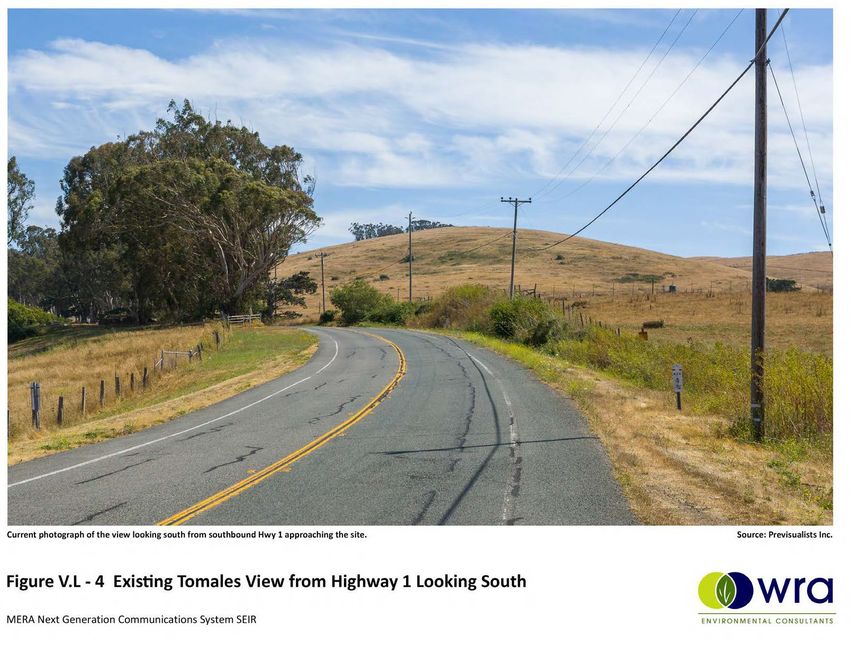
TABLE OF CONTENTS
Section 1 Introduction and Summary of Conclusions .............................. 1-1
1.1 Introduction ............................................................................................................................. 1-1
1.2 Summary of Conclusions ........................................................................................................ 1-3
Section 2 Project Modifications ............................................................. 2-1
2.1 Project Location ...................................................................................................................... 2-1
2.2 Summary of Original Approved Project Description ............................................................... 2-2
2.3 Modified Project ...................................................................................................................... 2-7
2.4 Modifications to Mitigation Measures ..................................................................................... 2-9
Section 3 Impact Analysis ................................................................... 3-10
3.1 Aesthetics ............................................................................................................................. 3-10
3.2 Cultural and Tribal Resources .............................................................................................. 3-13
3.3 Biological Resources ............................................................................................................ 3-15
3.4 Land Use Consistency .......................................................................................................... 3-18
3.5 Radio Frequency Exposure .................................................................................................. 3-19
3.6 Hazards and Hazardous Materials ....................................................................................... 3-20
3.7 Wildfire .................................................................................................................................. 3-21
Section 4 Conclusi on ............................................................................. 4-1
Section 5 Refer ences ............................................................................. 5-1
LIST OF FIGURES, PHOTOS AND TABLES
Table V-12. Tomales Site, Existing and Proposed Exterior Equipment 2-1
Photo III-13: Site 20 Tomales, near the trees, as seen from the private access road. 2-3
Figure III-13. Site 20 - Tomales Location Map 2-4
Figure III-14. Site 20 – Tomales Underground Electric Location 2-5
Figure III-45. Site 20 – Tomales Existing Equipment Photo and Proposed Elevation 2-6
Figure III-46. Site 20 – Tomales Enlarged Site Plan 2-6
Figure III-47. Site 20 – Tomales Site Plan 2-7
Figure III-46. Site 20 – Tomales Enlarged Site Plan (MODIFIED) 2-8
Figure Sheet E-2 – AT&T Power Trench and new MERA Proposed Trench 2-8
Figure V.L – 1 Tomales Aerial with Photo Locations 3-24
Figure V.L – 2 Existing Tomales Near View 3-25
Figure V.L – 3 Proposed Tomales Near View 3-25
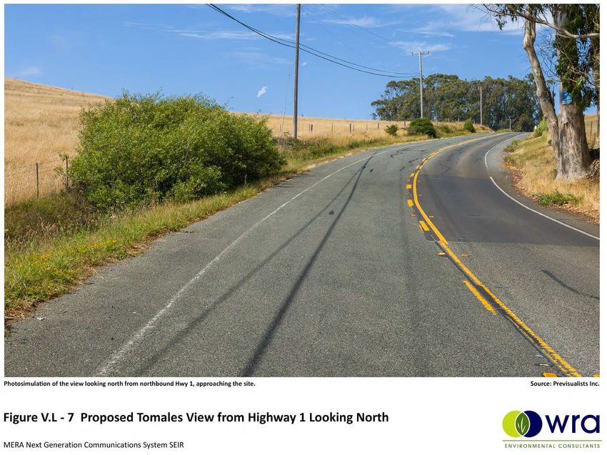
Figure V.L – 4 Existing Tomales View from Highway 1 Looking South 3-26
Figure V.L – 5 Proposed Tomales View from Highway 1 Looking South 3-26
Figure V.L – 6 Existing Tomales View from Highway 1 Looking North 3-27
Figure V.L – 7 Proposed Tomales View from Highway 1 Looking North 3-27
Figure V.L – 8 Existing Tomales View from Whittaker Bluff Road 3-28
Figure V.L – 9 Proposed Tomales View from Whittaker Bluff Road 3-28
Figure V.L – 10 Tomales 3-29
Figure V.L – 11 Tomales 3-30
Figure V.L – 12 Tomales Simulated All-On RF Exposure – Elevation View 3-31
Marin Emergency Radio Authority Next Generation Radio Communications System i
SEIR Addendum #1
Table of Contents

ii                  Nipomo Community Services District Supplemental Water Project
                                                                 EIR Addendum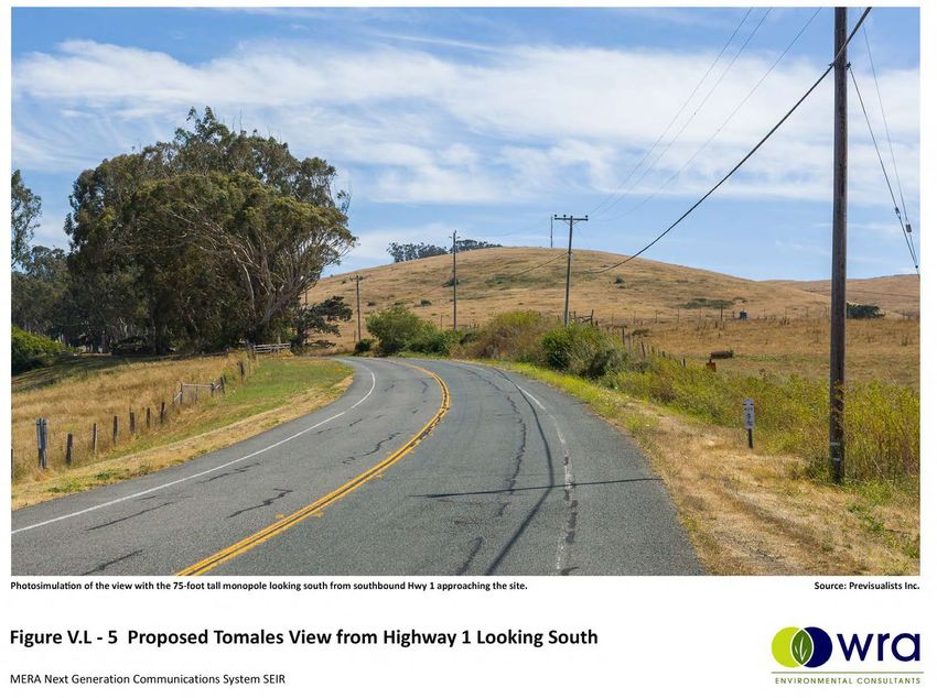
SECTION 1
INTRODUCTION AND SUMMARY OF CONCLUSIONS

1.1     INTRODUCTION
The Marin Emergency Radio Authority (MERA), serving as the lead agency under the California
Environmental Quality Act of 1970 (CEQA), certified a Final Subsequent Environmental Impact
Report (“2019 SEIR” or “Final SEIR”) for the Marin Emergency Radio Authority Next Generation
Radio Communication System (“approved project”) on December 11, 2019. The approved project
is an upgrade to Marin County’s existing radio communications system that will improve the
County’s emergency communications capabilities during daily public service and critical
emergencies. Prior to the Final SEIR, the Final EIR for the existing “Gen 1” system was approved
on February 24, 2000. As described in the Final SEIR, the approved project will replace
equipment at currently operating communications sites and install telecommunications facilities
at new sites where public and private infrastructure already exists. In total, ten existing sites will
be upgraded, eight new sites will be introduced, and five existing sites will be decommissioned.
The Final SEIR was based on preliminary engineering designs developed in conjunction with
Motorola.This document is a 1st Addendum to the 2019 SEIR to address modifications to the
power line trench at that was previously analyzed one of the sites, Tomales. The revised project
proposes to share a trench that is being constructed by AT&T to support an AT&T cellular site
nearby. This will eliminate the need for the MERA power trench as previously approved, and will
add a shorter trench to connect the AT&T power trench to the MERA Tomales site (“modified
project”).

The purpose of this Addendum is to evaluate potential environmental impacts associated with
proposed changes in the previously approved project, specifically, the new power trench location
and elimination of the approved power trench path. Additional CEQA review beyond this
Addendum, in the form of a supplemental or subsequent EIR, would only be necessary if the
proposed changes to the project created new significant impacts or a substantial increase in the
severity of significant impacts identified in the Final SEIR used to approve the project.

According to State CEQA Guidelines Section 15162:

        (a)   When an EIR has been certified or a negative declaration adopted for a
              project, no subsequent EIR shall be prepared for that project unless the lead
              agency determines, on the basis of substantial evidence in the light of the
              whole record, one or more of the following:

                     (1)   Substantial changes are proposed in the project which will require
                           major revisions of the previous EIR or negative declaration due to
                           the involvement of new significant environmental effects or a
                           substantial increase in the severity of previously identified
                           significant effects;

                     (2)   Substantial changes occur with respect to the circumstances
                           under which the project is undertaken which will require major
                           revisions of the previous EIR or Negative Declaration due to the
                           involvement of new significant environmental effects or a
                           substantial increase in the severity of previously identified
                           significant effects; or

Marin Emergency Radio Authority Next Generation Radio Communications System                        1-1
SEIR Addendum #1
Section 1

                   (3)   New information of substantial importance, which was not known
                         and could not have been known with the exercise of reasonable
                         diligence at the time the previous EIR was certified as complete
                         or the Negative Declaration was adopted, shows any of the
                         following:

                              (A)   The project will have one or more significant effects
                                    not discussed in the previous EIR or negative
                                    declaration;

                              (B)   Significant effects previously examined will be
                                    substantially more severe than shown in the previous
                                    EIR;

                              (C)   Mitigation measures or alternatives previously found
                                    not to be feasible would in fact be feasible, and would
                                    substantially reduce one or more significant effects of
                                    the project, but the project proponents decline to adopt
                                    the mitigation measure or alternative; or

                              (D)   Mitigation measures or alternatives which are
                                    considerably different from those analyzed in the
                                    previous EIR would substantially reduce one or more
                                    significant effects on the environment, but the project
                                    proponents decline to adopt the mitigation measure or
                                    alternative.

Section 15164 provides the following guidance for preparation of an EIR addendum:

        (a)   The lead agency or responsible agency shall prepare an addendum to a
              previously certified EIR if some changes or additions are necessary but none
              of the conditions described in Section 15162 calling for preparation of a
              subsequent EIR have occurred.

        (c)   An addendum need not be circulated for public review but can be included in
              or attached to the final EIR or adopted negative declaration.

        (d)   The decision-making body shall consider the addendum with the final EIR or
              adopted negative declaration prior to making a decision on the project.

        (e)   A brief explanation of the decision not to prepare a subsequent EIR pursuant
              to Section 15162 should be included in an addendum to an EIR, the lead
              agency's findings on the project, or elsewhere in the record. The explanation
              must be supported by substantial evidence.

This Addendum has been prepared consistent with State CEQA Guidelines Sections 15162 and
15164 to document that the proposed project modifications would not result in new significant
impacts or a substantial increase in the severity of a previously identified significant impact;
therefore, preparation of a supplemental or subsequent EIR is not required.

1-2                             Marin Emergency Radio Authority Next Generation Radio Communications System
                                                                                         SEIR Addendum #1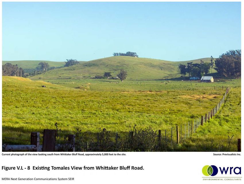
Introduction and Summary of Conclusions

1.2     SUMMARY OF CONCLUSIONS
This 1st Addendum to the 2019 SEIR demonstrates that the environmental analysis, impacts, and
mitigation requirements identified in the 2019 SEIR remain substantively unchanged by the
project modifications described herein, and supports the finding that the modified project does not
raise any new issues and does not exceed the levels of impact significance identified in the 2019
SEIR. Accordingly, preparation of a subsequent or supplemental EIR is not necessary pursuant
to State CEQA Guidelines Sections 15162 and 15164. This decision is based on substantial
evidence, as set forth in the following discussion of the proposed project modifications and the
environmental impacts of those modifications.

This Addendum need not be circulated for public review (State CEQA Guidelines Section
15164(c)); however, an addendum is required to be considered by the decision-making body
along with the previously certified 2019 Final SEIR prior to making a decision on the modified
project (State CEQA Guidelines Section 15164(d)).

Marin Emergency Radio Authority Next Generation Radio Communications System                               1-3
SEIR Addendum #1
SECTION 2
PROJECT MODIFICATIONS
2.1 PROJECT LOCATION
The Marin Emergency Radio Authority (MERA) is a Joint Powers Authority (JPA) providing public
safety voice radio communications for the 25 member agencies in Marin County, CA. The Next
Gen Project, as approved, includes 18 communications sites, 17 of which are located in Marin
County and one in Sonoma County. This SEIR Addendum #1 involves only one of those sites,
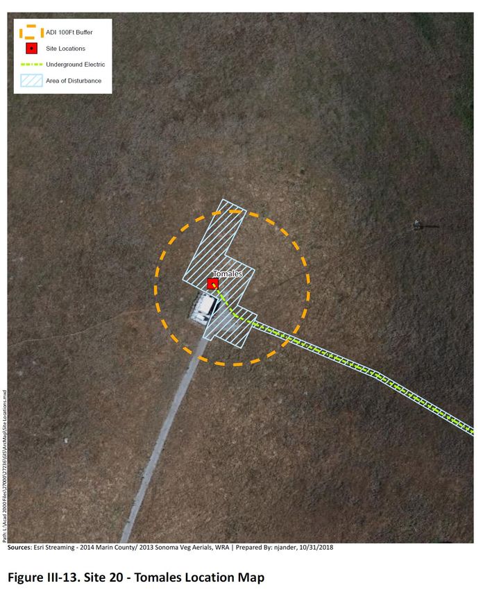
the Tomales site. The Tomales site is located at Parks Ranch near Tomales, with access via a
dirt driveway off of State Route 1, as more particularly described below and as shown in Figure
III-13:
Site APN Ground Jurisdiction Coordinates Previous Comments
Number Elevation EIR
and Name (ft)
20. 100-050-42 487.0 Marin 38.017000, No New Site with
Tomales County -122.546000 cell tower and
equipment.
The Tomales Site is a new site to which MERA facilities will be added, rather than an existing
MERA site that is being upgraded. Construction at this site has not started.
The Tomales Site is situated approximately one mile north of the Town of Tomales on a small
hilltop that currently contains a cellular facility. The surrounding agricultural land is characterized
by grassy, rolling hills, fencing, and open space, as shown in Photo III-13 (SEIR Chapter III,
Project Description). Development in the area is sparse, with occasional residences punctuating
the otherwise open landscape. Much of the area is actively used for grazing, and the site is zoned
Costal Agricultural Production Zone (C-APZ).
Details of the work for the Next Gen System at the Tomales Site are explained in Chapter III,
Project Description, of the SEIR. In summary, project improvements include a new 75-foot
monopole, small equipment shelter, emergency generator and fuel tank, and fencing as describe
below in Table V-12. The site is accessed via an existing graded road that connects the cellular
site with State Route 1.
MERA will lease the land for the radio site from the property owner and will use the existing graded
road for access. After completion of the Next Gen project, an estimated 70% of the visible
components at the hilltop site would be owned by MERA.
Table V–12. Tomales Site, Existing and Proposed Exterior Equipment
Site Name Existing Infrastructure at Site Physical Changes Analyzed in
2019 SEIR
Tomales Existing cell tower and equipment Propose new 75' tall monopole,
shelter sited to minimize visual new shelter,
Marin Emergency Radio Authority Next Generation Radio Communications System 2-1
SEIR Addendum #1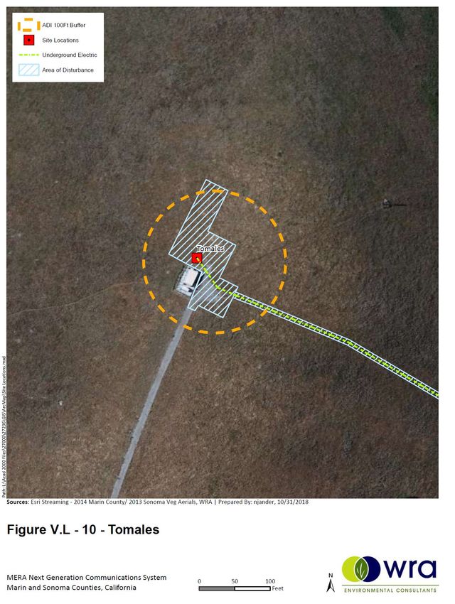
Section 3

                       impacts.                                 fence, generator, and fuel tank.

                                                                2 microwave dishes and 3
                                                                antennas added.

                                                                2 microwave dishes and 3
                                                                antennas added.
                                                                New below-ground power cable
                                                                from SE corner
                                                                of site to follow same path as
                                                                existing
                                                                underground line.

2.2     SUMMARY OF ORIGINAL APPROVED PROJECT DESCRIPTION
The MERA radio system is vital for emergency countywide communications between police,
firefighters and public works crews. The emergency communications system is a network of radio
antennas and equipment linked with microwave connections. However, the combination of older
equipment, system capacity, coverage and recent changes to frequency requirements by the
Congressional Jobs Bill HR 3630 now requires an upgrade of all Ultra High Frequency (T‐band)
radio communications systems, including the MERA system. The Next Gen System will update
the current backbone network to utilize new radio frequencies in the 700MHz band to vacate the
UHF (T‐band) frequencies currently utilized. The Next Gen System will also utilize Project 25
(P25) technology to provide improved public service and emergency radio coverage within the
County of Marin. Funding for the project is generated by a parcel tax that was authorized by Marin
County voters in 2014. (WRA, 2019)

Since the 2019 SEIR was approved, the Congressional Jobs Bill HR 3630 requirement to leave
the current UHF-T band frequencies was repealed in December 2020. This change has not
resulted in any changes to the MERA Next Generation Radio Communication System project.

The current MERA system includes 15 active communications sites. The Next Gen System will
retain and upgrade 10 of the functioning sites, decommission five existing sites and add
equipment to eight new sites, which include previously developed infrastructure not part of the
MERA system. Existing infrastructure at the eight new sites include communication facilities or
water storage tanks, and a water wellhead site in northern Marin County.

Existing sites used in Next Gen System:       New sites in Next Gen System:

Civic Center                                  Prime Site (Sheriff’s dispatch center)
Big Rock Ridge                                Tomales (existing cell phone site)
Mt. Tamalpais                                 Coyote Peak (a water wellhead site)
Mt. Barnabe                                   Skyview Terrace (an MMWD water tank site)
Point Reyes Hill                              Muir Beach (a local water tank site)
Dollar Hill                                   Wolfback Ridge (an existing broadcast tower)
San Pedro Ridge                               OTA Mt. Burdell (an existing broadcast tower)
Mt. Tiburon                                   Mill Valley Water Tank (MMWD water tank)
Sonoma Mountain
Stewart Point

2-2                            Marin Emergency Radio Authority Next Generation Radio Communications System
                                                                                        SEIR Addendum #1
Impact Analysis
The five sites to be decommissioned as part of the Next Gen System are: Forbes Hill in San
Rafael, Mt. Burdell near Novato, Mill Valley City Hall and Mill Valley Police Station, and the Bay
Hill Road site in Sonoma County.
As described in the SEIR, the existing conditions at the Tomales site include an existing cell tower
site, with two small towers and an equipment shelter. No MERA facilities have yet been
constructed or installed. A photo of the site is provided below (Photo III-13). (Figure III-13). There
are aboveground and belowground utilities along State Route 1, approximately 500 and 700 feet
from the site, respectively (Figure III-14).
Elevations of the MERA Next Gen System equipment, as approved, are provided in FigureIII-45;
an overall site plan is provided in Figure III-46; and a detailed Tomales site plan is in Figure III-
47. All elevation figures and site plans are included at the end of this section. As analyzed in the
2019 SEIR and as currently approved, the MERA Next Gen System includes the following
improvements, with MERA ultimately controlling about 70% of the visible communications
equipment at the site:
• New 75-foot-tall monopole mounted with one 3-foot-diameter and one 6-foot-diameter
microwave dishes, and three vertical pole and five dipole antennas;
• New equipment shelter measuring 150 square feet in area and 10 feet high;
• New generator and fuel tank;
• New 6-foot-tall perimeter fence; and
• New belowground power cable from the southeast corner of the site to follow the same
path as the existing underground line.
Photo III-13: Site 20 Tomales, near the trees, as seen from the private access road.
Marin Emergency Radio Authority Next Generation Radio Communications System 2-3
SEIR Addendum #1Section 3
2-4 Marin Emergency Radio Authority Next Generation Radio Communications System
SEIR Addendum #1Impact Analysis Marin Emergency Radio Authority Next Generation Radio Communications System 2-5 SEIR Addendum #1
Section 3

2-6         Marin Emergency Radio Authority Next Generation Radio Communications System
                                                                     SEIR Addendum #1
Impact Analysis 2.3 MODIFIED PROJECT The modified project would eliminate the approved 705 ft power trench that was analyzed in the 2019 SEIR and is shown in Figure III-14, above. Instead, MERA proposes installing a new, approximately 50-foot power trench that will connect the MERA Tomales Site with an AT&T power trench, along a route not previously analyzed in the 2019 SEIR. This new 50-foot power trench will begin under the approved turnaround area, immediately south of the MERA Tomales Site and continue north for approximately 50 feet to the MERA Tomales Site building. The entire length of this 50-foot trench will be under ground that has already been approved for disturbance. See Figure III-46 (Modified). The design, depth, width and materials will be consistent with the approved power trench that it replaces. AT&T also plans to install conduit and pull boxes into their power trench, from the PG&E connection to a point near the MERA Tomales Site. (See Figure – Sheet E-2 on page 2-8). The AT&T power trench is part of a separate and unrelated project carried out by AT&T, and is not a part of the MERA Project. Marin Emergency Radio Authority Next Generation Radio Communications System 2-7 SEIR Addendum #1
Section 3

Figure Sheet 2 – AT&T Power Trench

2-8                       Marin Emergency Radio Authority Next Generation Radio Communications System
                                                                                   SEIR Addendum #1
Impact Analysis 2.4 MODIFICATIONS TO MITIGATION MEASURES Based on the scope of the modified project and the analysis below, no modifications to the existing mitigation measures or new mitigation measures are recommended. Marin Emergency Radio Authority Next Generation Radio Communications System 2-9 SEIR Addendum #1
Section 3

SECTION 3
IMPACT ANALYSIS
An Initial Study (IS) was prepared for the 2000 MERA Emergency Communications Radio System
Environmental Impact Report. The Initial Study and the EIR determined that the project would not
result in significant environmental impacts within the categories listed below. Therefore, the
possible effects of the project in these areas were not analyzed in detail in the 2000 EIR.

1. Agricultural Resources                       8. Noise*
2. Air Quality*                                 9. Population and Housing
3. Cultural Resources*                          10. Public Services
4. Geological Problems*                         11. Recreation
5. Water*                                       12. Transportation and Circulation
6. Land Use and Planning**                      13. Utilities and Service Systems
7. Energy and Mineral Resources

* Five topics listed above required agency regulation measures in the IS to ensure impacts would be less
than significant, including: Air Quality, Cultural Resources, Geological Problems, Water and Noise.

** MERA is exempt from local agency regulation and is only subject to state and federal regulatory
provisions.

With the exception of Cultural Resources, the above impact areas were similarly not analyzed in
detail in in the 2019 SEIR. The 2019 SEIR specifically evaluated the Tomales Site for the following
potential environmental impacts: Aesthetics, Cultural and Tribal Resources, Biological
Resources, Land Use Consistency, and Radio Frequency Exposure. In addition, the SEIR
evaluated the entire project for the following environmental impacts: Hazards and Hazardous
Materials and Wildfire. References to tables, figures and photographs not included in this
Addendum #1 are included in the 2019 SEIR (WRA 2019).

These potential impacts, and all other impact areas required to be evaluated under CEQA, have
been re-evaluated in this 1st Addendum for the proposed changes to the Tomales Site Power
Trench change. This evaluation determines whether the modified project would result in any new
significant impacts or substantially more severe impacts than those identified in the 2019 SEIR.

3.1     AESTHETICS
Although the Tomales Site is new to the MERA radio system, the hilltop is already developed with
a cellular communications facility. This existing facility consists of a 240 square foot equipment
shelter and a 60-kilowatt diesel emergency generator inside of a fenced compound. The antennas
for the facility are mounted on two separate monopole towers away from the main compound:
one 18-foot high, 6-inch diameter monopole supporting two 4-foot long panel antennas is
approximately 300 feet west of the shelter, and one 25-foot high, 6-inch diameter monopole
supporting four 4-foot long panel antennas is approximately 300 feet southwest of the shelter.
Each monopole is enclosed in 4-foot high cattle fencing. The monopoles are located a minimum
of 400 feet west of State Route 1. The existing cellular equipment enclosure is visible from a
distance but has limited near distance visibility, since the highway is approximately 300 feet below
the peak of the rounded knoll.

3-10                             Marin Emergency Radio Authority Next Generation Radio Communications System
                                                                                          SEIR Addendum #1
Impact Analysis
Similarly, visibility of MERA’s facilities will be limited at close distances but be visible from several
distant points along State Route 1. MERA’s equipment will include a new equipment shelter,
emergency generator, fuel tank, 75-foot monopole, a perimeter fence, and underground power
cables. The highest antenna on the proposed monopole would increase the maximum height to
nearly 80 feet. Figures III-45 through III-47 in the SEIR show the proposed physical changes at
the project site for the approved project.
The current modification involves removing the approximately 705-foot power trench depicted in
blue in figure III-46 (Modified), and adding an approximately 50-foot power trench shown in red in
that same figure. The new power trench in this modification lays entirely within the area of
disturbance, beginning under the turnaround immediately south of the MERA fence and running
north, under that fence to a connection at the MERA building. This entire length of the new trench
will not be visible from the public roadways and once completed will be covered by the access
road into the MERA site and the MERA site itself.
Key Observation Points (KOPs) have been selected to represent the full array of viewpoints from
which the Tomales Site is visible. The SEIR includes simulated before and after conditions are
portrayed for each KOP, and a map showing the site and the representative vantage points is
provided as Figure V.L-1. Subsequent Figures V.L-2 through V.L-9 show the anticipated before
and after conditions at the Tomales Site from the four selected KOPs.
Aesthetic resources in the vicinity of the Tomales Site include State Route 1 and the agricultural
character of the surrounding landscape. Views from State Route 1 in this area are of the interior
coast range, featuring verdant green or golden (depending on the season) grassy hillsides. From
other surrounding roads, motorists enjoy scenic views of surrounding agriculture, open space and
rolling hills. Occasionally there are broader vistas from elevated roadways overlooking the coastal
valleys.
State Route 1 curves around the lower eastern edge of the Tomales Site, and the site’s rounded
knoll and existing eucalyptus trees prevent close-up views of the existing cellular facility from most
of this segment of the highway, although the site is briefly visible to motorists traveling
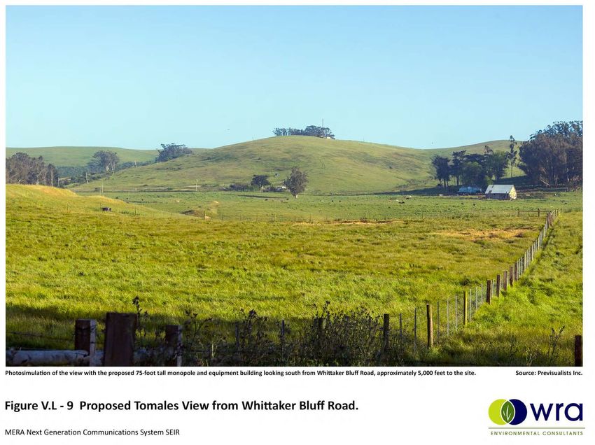
southbound. Other publicly accessible scenic views of the Tomales Site exist further to the north
from State Route 1 and from Whittaker Bluff Road, approximately one mile away.
Impact determinations are made using the KOPs in conjunction with proximate protected scenic
resources such as parks and scenic highways. As part of the determination, the following
thresholds were considered:
a) Would the project have a substantial adverse effect on a scenic vista?
A scenic vista is defined as an aesthetically pleasing overview of a broad landscape. FiguresV.L-
1 through V.L-9 depict the site’s present visual character and simulated visual conditions upon
project completion. The Tomales Site appears as a grassy knoll in an agricultural setting with a
small structure visible from distant vantage points.
There are no designated scenic vistas in the area, although there is a brief vista from State Route
1, with an overview of the agricultural valley to the northeast looking towards Two Rock and
Sonoma Mountain. This view would be unaffected by the modified project because it is behind
the viewer and because the topography limits views toward the project from Two Rock Road.
Upon project completion, the new 75-foot monopole would be visible from distant public vantage
points, but none of these could be characterized as scenic vistas.
Marin Emergency Radio Authority Next Generation Radio Communications System 3-11
SEIR Addendum #1Section 3
The modification of the power trench, as described above, will reduce visibility of the trenching
work during construction and result in a trench that is not visible from the public roadways or
scenic vistas and the aesthetic impacts of the entire site would be consistent with that depicted in
V.L-1 through V.L-9. Consequently, impacts on scenic vistas will be substantially the same
or less than determined by the 2019 SEIR.
b) Would the project substantially damage scenic resources, including, but not limited to,
trees, rock outcroppings, and historic buildings within a state scenic highway?
State Route 1 is not an officially designated state scenic highway, but it is eligible for designation.
Accordingly, this analysis considers State Route 1 (Highway 1) as a scenic roadway due to its
quality views of coastal California. Presently, views of the Tomales Site from Highway 1 include
the grassy knoll with a backdrop of eucalyptus trees. Development within this viewscape is
generally limited to ranch facilities and equipment, barbed wire cattle fencing, power lines, and
the paved roadway. Upon project completion the 75-foot monopole would be visible from State
Route 1, particularly to southbound motorists, where the monopole would briefly feature
prominently behind the power lines that parallel the highway (Figures V.L-4 and V.L-5). To
northbound motorists leaving the Town of Tomales, the very top of the monopole briefly appears
above the ridgeline (Figures V.L-6 and V.L-7).
The project would not directly damage any scenic resources such as trees, rock outcroppings, or
historic buildings at the Tomales Site. However, the brief view of the coastal agricultural setting
as motorists drive south on State Route 1 is a scenic resource that would be altered by the project.
Despite the implementation of Mitigation Measure AES-2 calling for screening and color blending
design features, the addition of a 75-foot tall monopole and equipment shelter to the grassy knoll,
and the visual impact on the landscape is significant and unavoidable.
However, as related to the modification of the power trench, as described above, the location and
significantly shorter length of the new power trench will reduce visibility of the trenching work
during construction and result in a trench that is not visible from the public roadways or scenic
vistas; accordingly, the aesthetic impacts of the entire site would be consistent with that depicted
in V.L-1 through V.L-9. Consequently, impacts will be substantially the same or less than
determined by the 2019 SEIR.
Mitigation Measure AES-2
A six-foot tall, dark or earth-tone colored, opaque fence shall be incorporated into the
perimeter fence on the north and west sides of the MERA facility to screen views of the
equipment shelter from State Route 1 and from Whitaker Road. The fence shall also
screen the same views of the existing cellular equipment structure, with permission from
the owner/operator of that facility. Painted wood, permanently colored composite material
(Trex or similar), or black vinyl chain-link with dark vinyl slats are material options suitable
to screen views of the equipment structures.
MERA shall maintain the proposed galvanized grey color of the 75-foot monopole because
it will result in minimal contrast with the sky on the hilltop location. Implementation of the
described mitigation measures will lessen the visual impacts to a state scenic highway
and other scenic roads in the area but the impacts would still remain significant and
unavoidable.
3-12 Marin Emergency Radio Authority Next Generation Radio Communications System
SEIR Addendum #1Impact Analysis
c) Would the project substantially degrade the existing visual character or quality of public
views of the site and its surroundings? If the project is in an urbanized area, would the
project conflict with applicable zoning and other regulations governing scenic quality?
The visual character of the Tomales area is defined by rolling coastal hills and mostly undeveloped
grazing land. The introduction of the 75-foot monopole tower, a prominent structure on top of the
knoll (Figures V.L-2 and 3), in an otherwise minimally developed, non-urbanized area would
adversely affect the agricultural setting and would substantially affect the visual character and
quality of the site and its surroundings as viewed from publicly accessible areas, such as Whitaker
Road and State Route 1. Therefore, the impact is significant and unavoidable.
However as related to the modification of the power trench, as described above, the location and
significantly shorter length of the new power trench will reduce visibility of the trenching work
during construction and result in a trench that is not visible from the public roadways or scenic
vistas; accordingly, the aesthetic impacts of the entire site would be consistent with that depicted
in V.L-1 through V.L-9. Consequently, impacts will be substantially the same or less than
determined by the 2019 SEIR.
Mitigation Measure AES-3
Upon completion of tower and structure construction, MERA shall remove all debris from
the site, define all vehicular access points and turnarounds, and complete finish grading
including road surfacing where needed and soil preparation for planting. Vehicular areas
shall be graded to drain and clay soils surfaced with gravel. Areas outside of vehicular
zones shall be loosened or scarified if compacted, amended as needed and prepared to
facilitate native seed germination. Hydroseed/mulch or hand-broadcast seeding and
mulch shall complete site restoration. For sites steeper than 3:1 restored areas shall also
include installation of straw waddles perpendicular to the slope at 20-foot intervals.
The equipment shelter, fuel tank, and emergency generator shall be painted dark earth
tone colors to minimize contrast in the landscape and chain link fencing shall be black
vinyl-coated.
Original Conclusion: With implementation of the described visual mitigation measures the
impact would remain significant and unavoidable.
Conclusion based on the Modified Project: The modified project significantly reduces the
length of the power trench that will be constructed by MERA, and moves it to a less observable
location farther from public roads and immediately adjacent to the other communications
facilities. Therefore, the aesthetic effects associated with the modified project would be
substantially similar to the effects described in the 2019 SEIR. The modified project would not
result in new significant impacts or substantially more severe significant impacts than were
identified in the SEIR, and no additional mitigation is necessary.
3.2 CULTURAL AND TRIBAL RESOURCES
The 2019 SEIR considered the following thresholds with respect to the project’s impacts on
cultural and tribal resources.
a) Would the project cause a substantial adverse change in the significance of a historical
resource pursuant to Section 15064.5?
Marin Emergency Radio Authority Next Generation Radio Communications System 3-13
SEIR Addendum #1Section 3
The Cultural Resources Inventory Report (GANDA, October 2018) commissioned for this project,
which incorporated records searches and site visits, found no known historical resources pursuant
to Section 15064.5 within or near the Tomales Site. Ground disturbance would reach depths of
approximately five feet below ground level in order to install the foundation of the proposed
monopole, the new fence, shelter foundation, fuel tank foundation, and the underground power
line. The Area of Direct Impact and a surrounding 100-foot buffer are shown in Figures V.L-10
and V.L-11, and include the modified power trench location.
Despite the extensive nature of proposed disturbance at this location relative to other Next Gen
Sites, accidental discovery of historical resources remains unlikely due to the soil types underlying
the site. Nonetheless, work at the Tomales Site would comply with Mitigation Measure CULT-1
(please see page IV.B–10) and California law governing procedures for the accidental discovery
of historical resources. By implementing Mitigation Measure CULT-1, the project would not cause
a substantial adverse change in the significance of a historical resource in or near the Tomales
Site, and impacts would be less than significant with mitigation incorporated. The impacts of the
modified project will be substantially the same.
Tribal Cultural Resources
a,b) Would the project cause a substantial adverse change in the significance of a tribal
cultural resource, defined in PRC Section 21074 as either a site, feature, place, cultural
landscape that is geographically defined in terms of the size and scope of the landscape,
sacred place, or object with cultural value to a California Native American tribe, and that
is a resource determined by the lead agency, in its discretion and supported by substantial
evidence, to be significant pursuant to criteria set forth in subdivision (c) of Public
Resources Code Section 5024.1? In applying the criteria set forth in subdivision (c) of
Public Resources Code Section 5024.1, the lead agency shall consider the significance
of the resource to a California Native American tribe.
Original Conclusion: Public agencies are required to consult with California Native American
tribes that are on the Native American Heritage Commission’s (NAHC) consultation list and are
traditionally and culturally affiliated with the geographic area of a proposed project that is subject
to the California Environmental Quality Act (CEQA). Consultation with the Federated Indians of
Graton Rancheria (FIGR) began on June 5, 2018, and concluded on February 8, 2019. FIGR
identified a potential for adverse change to the significance of tribal cultural resources at 13 Next
Gen Sites, and the Tomales Site was among these sites. However, by implementing Mitigation
Measures TRIBE-1, TRIBE-2, and TRIBE-3 (please see page IV.B-12 and IV.B-13), the proposed
project would not cause a substantial adverse change in the significance of a tribal cultural
resource, and impacts would be less than significant with mitigation incorporated.
Conclusion based on the Modified Project: As the modified project is a minor change that
reduces the length of the power trench that will be constructed by MERA, the potential impacts
to cultural and tribal resources will be substantially similar to the effects described in the 2019
SEIR. The modified project would not result in new significant impacts or substantially more
severe significant impacts than were identified in the SEIR, and no additional mitigation is
necessary.
3-14 Marin Emergency Radio Authority Next Generation Radio Communications System
SEIR Addendum #1Impact Analysis
3.3 BIOLOGICAL RESOURCES
The 2019 SEIR considered the following thresholds with respect to the project’s impacts on
biological resources.
a) Would the project have a substantial adverse effect, either directly or through habitat
modifications, on any species identified as a candidate, sensitive, or special-status
species in local or regional plans, policies, or regulations, or by the CDFW or USFWS?
The Tomales Site is surrounded by heavily grazed, disturbed, non-native annual grassland, which
provides limited habitat for special-status plant species. However, because of the close proximity
(within 5 miles) of numerous documented special-status plant species, and due to the proposed
ground disturbance work within previously undeveloped grassland habitat, focused, protocol-level
special-status plant surveys were conducted within the site on March 30, May 9, and June 20,
2018.
The following special-status plant species were identified as having a moderate or high potential
to be present within undeveloped non-native annual grassland portions of the site: bent-flowered
fiddleneck (Amsinckia lunaris), fragrant fritillary (Fritillaria liliacea), congested-headed hayfield
tarplant (Hemizonia congesta ssp. congesta), bristly leptosiphon (Leptosiphon acicularis),
largeflowered leptosiphon (Leptosiphon grandiflorus), marsh Microseris, and two-fork clover
(Trifolium amoenum). Several special-status plant species with potential to occur at the Tomales
Site were observed at other locations, including: bent-flowered fiddleneck (observed March 30,
2018 along Highway 1, south of Tomales), fragrant fritillary (observed April 1, 2018 at Nicasio
Reservoir), congested-headed hayfield tarplant (observed June 6, 2018 along Bodega Avenue in
Petaluma), and bristly leptosiphon (observed April 8, 2018 at Taylor Mountain Regional Park in
Santa Rosa). However, no special-status plant species were observed in the biological study area
(the project site plus an approximate 100-foot radius), and the 2019 SEIR found that the approved
project would have no impact on special-status plant species.
The following special-status wildlife species were assessed as having a moderate or high
potential to be present at the Tomales site: American badger, burrowing owl, grasshopper
sparrow, Bryant’s savannah sparrow, northern harrier, and California red-legged frog. Burrowing
owls inhabit open grassland with sparse or non-existent tree or shrub canopies. Burrowing owl
individuals have been observed in the vicinity as recently as January 2018. Burrows and friable
soils were observed during the site visit, including a potential badger burrow. The open grassland
can also support nesting and foraging for grasshopper sparrow, white-tailed kite, northern harrier,
and Bryant’s savannah sparrow. California red-legged frog has been documented within one mile
of the study area at Stemple Creek. California red-legged frog may be present in the study area
after rain during dispersal events. Unmitigated, the 2019 SEIR found that the approved project
could adversely affect candidate, sensitive, or special-status species at the Tomales Site, but by
implementing Mitigation Measures BIO-2 (see Site 8, Point Reyes Hill) and BIO-3 through BIO-5
(below), impacts would be reduced to less-than-significant levels, and impacts to these species
would be less than significant with mitigation incorporated. As the modified power trench would
be located within the project site that was previously analyzed, the impacts would be substantially
the same.
Mitigation Measure BIO-3
No more than 14 days before the start of ground disturbance activities at the Tomales
Site, a biologist shall conduct pre-construction surveys of the project site and a
Marin Emergency Radio Authority Next Generation Radio Communications System 3-15
SEIR Addendum #1Section 3
surrounding 50-foot buffer to determine if American badger dens are present. If a den is
determined to be active and occupied by a female with young, ground disturbance and
construction activity shall be avoided within 50 feet of the den until the young have matured
and dispersed. If a den is determined to be active, but a female with young are not present,
burrow exclusion using passive measures such as one-way doors or equivalent shall be
attempted for a minimum of three days to discourage their use prior to any project-related
ground disturbance. If the biologist determines that the dens have become inactive as a
result of the exclusion methods, the dens shall be excavated by hand to prevent them
from being re-occupied during construction.
Mitigation Measure BIO-4
Work at the Tomales Site shall be avoided during night hours (half an hour before sunrise
to half an hour before sunset) when California red-legged frog may be dispersing across
the site. In addition, no ground disturbing work shall occur within 24 hours of rain events
that generate greater than 0.25 inch of accumulated precipitation or during rain events
predicted to accumulate 0.25 inch of precipitation.
Mitigation Measure BIO-5
A pre-construction burrowing owl survey shall be performed prior to start of ground
disturbance activities at the Tomales Site, regardless of the time of year, as burrowing
owls may use the project site during the non-nesting season. The survey shall be
performed according to the standards set forth by the 2012 CDFW Staff report for
Burrowing Owl Mitigation. Occupied burrows shall not be disturbed during the nesting
season (February 1 through August 31) unless, after consultation with the CDFW, a
qualified biologist verifies that either: (1) the birds have not begun egg-laying and
incubation; or (2) that juveniles from the occupied burrows are foraging independently and
capable of independent survival.
b-c) Would the project have a substantial adverse effect on any riparian habitat or other
sensitive natural community identified in local or regional plans, policies, regulations or by
the CDFW or USFWS; or have a substantial adverse effect on federally protected
wetlands as defined by Section 404 of the Clean Water Act (CWA)?
The surrounding habitat consists of heavily grazed, disturbed, non-native annual grassland
dominated by slim oat, soft chess, and common velvet grass (Holcus lanatus), with other
predominantly non-native grass and forb species present including ripgut brome, foxtail barley,
milk thistle (Silybum marianum), hairy cats ear (Hypochaeris radicata), and Italian thistle (Carduus
pycnocephalus ssp. pycnocephalus). Non-native annual grassland is not considered a sensitive
biological community. No sensitive biological communities are present, including federally
protected wetlands. Accordingly, work on the modified project would have no impact on sensitive
biological communities or federally protected wetlands.
d) Would the Project interfere substantially with the movement of any native resident or
migratory fish or wildlife species or with established native resident or migratory wildlife
corridors, or impede the use of native wildlife nursery site?
The Tomales Site is adjacent to an existing cellular communications site in an otherwise
undeveloped portion of Marin County and is new to the MERA Radio System. Improvements
included in the approved project include a new monopole, equipment shelter, fence, emergency
3-16 Marin Emergency Radio Authority Next Generation Radio Communications System
SEIR Addendum #1Impact Analysis
generator, fuel tank, and underground power line. Of these, the fence would have the most
potential to interfere with wildlife movement. The proposed fence would be six feet tall, and the
fenced compound would be 35 by 39 feet wide, enclosing a total area of 1,365 square feet.
Outside of the fence, the area would remain as undeveloped, open grassland. As the proposed
fence would be relatively short and is surrounded by otherwise undeveloped land, it would not
present a substantial impediment to wildlife movement. The 2019 SEIR determined that the
Project would not substantially interfere with the movement of native residence or migratory
wildlife species or with established native resident or wildlife corridors or nursery sites; thus,
impacts would be less than significant. As the modified power trench route will be underground,
effects of the modified project will be substantially similar.
e) Would the project conflict with any local policies or ordinances protecting biological
resources, such as a tree preservation policy or ordinance?
The Tomales Site is located within the jurisdiction of Unit 1 of the Marin County Local Coastal
Program (LCP), a state-wide program with local implementation at the county scale. LCP Unit 1
policies and regulations protecting biological resources potentially relevant to the Tomales Site
include Policies Habitat Protection 23, 25, and 26. Policy 23 requires that disturbance to nesting
and breeding wildlife be minimized, Policy 25 requires that impediments to wildlife movement be
avoided, and Policy 26 requires that upland grassland feeding areas be protected against
significant disruption of habitat values.
Mitigation Measures BIO-2, BIO-3, and BIO-5 require pre-construction surveys for breeding and
nesting wildlife that may use the project site and buffers around disturbance areas should any
active nests or burrows be identified. With implementation of these measures, the 2019 SEIR
found that the project would not conflict with Policy 23. The fence at the Tomales Site will enclose
a small area that is otherwise surrounded by open space, and is not sufficiently large to preclude
wildlife movement and dispersal throughout the area. As such, the 2019 SEIR found that the
approved project does not conflict with Policy 25. The non-native grassland present within the site
is of limited habitat value and is predominately used for cattle grazing. The area of permanent
vegetation removal would not be sufficiently large to degrade the quality of the adjacent grassland.
Consequently, the 2019 SEIR found there to be no conflict with Policy 26. As the modified project
involves a significantly shorter power trench in a location that is immediately adjacent to other
communications facilities, impacts of the modified project will be reduced or substantially similar.
Original Conclusion: In conclusion, with incorporation of Mitigation Measures BIO-2, BIO-3,
BIO-4, and BIO-5 to reduce impacts to breeding wildlife, there would be no conflict with the Marin
County LCP’s policies protecting biological resources, and impacts would be less than
significant with mitigation incorporated.
Conclusion based on the Modified Project: As the modified project is a minor change that
reduces the length of the power trench that will be constructed by MERA, the potential impacts
to biological resources will be substantially similar to or less than the effects described in the
2019 SEIR. The modified project would not result in new significant impacts or substantially
more severe significant impacts than were identified in the SEIR, and no additional mitigation is
necessary.
Marin Emergency Radio Authority Next Generation Radio Communications System 3-17
SEIR Addendum #1Section 3
3.4 LAND USE CONSISTENCY
CEQA Guidelines Appendix G asks three questions regarding land use. Questions a) and c) are
addressed in Chapter IV.D (Land Use Consistency) of the 2019 SEIR, which looks at Land Use
issues for the MERA Next Gen Project as a whole. As the modified project involves a minor
change to the power trench at the Tomales Site, its impacts will be substantially the same as
previously analyzed. Because the Tomales site is under state or federal jurisdiction, consistency
with threshold b) of the Appendix G is separately analyzed below:
b) Would the project conflict with any applicable land use plan, policy, or regulation of an
agency with jurisdiction over the project (including, but not limited to the general plan,
specific plan, local coastal program or zoning ordinance) adopted for the purpose of
avoiding or mitigating environmental effect?
The Tomales Site is located within the jurisdiction of Unit II of the Marin County LCP. It is
designated as C-AG- 1 (Agriculture Coastal Zone) and zoned C-APZ-60 (Agriculture Production
Zone Coastal). Within LCP Unit II, an emergency radio facility is a permitted use in the C-APZ
zone, subject to a Coastal Development Permit. The emergency radio facility also meets the
definition of a ‘Project’ under the Coastal Zone regulations that also makes it subject to a Coastal
Development Permit. The C-APZ zone is a master planning district, typically requiring the
approval of a master plan evaluated against a set of agricultural-related criteria, but the Marin
CDA Director can waive the master plan requirement. The County Development Code for the
Coastal Zone in this area allows for a building height up to 25 feet and a tower height up to 150
feet on the property. The Development Code grants the Zoning Administrator the authority to
approve a use permit and coastal permit for a public utility or service; however, MERA is not
subject to this County-level permit and will be working with the County (as an agent of the State)
to acquire a Coastal Development Permit. Furthermore, Section 22.57.0331(17) allows
“Construction or alteration of gas, electric, water, communication or flood control facility unrelated
to an agricultural use, as approved by the appropriate government agency”. As a result, the
emergency radio facility is a permitted use in the C-APZ-60 zone.
Section 22.70.040I exempts towers from the zoning district height limit provided the tower does
not cover more than 15% in area of the lot nor has a base greater than 1,600 square feet. The
maximum tower height is limited to 150 feet. The approved emergency radio monopole has a
base diameter of 32 inches and a height of 75 feet, well within the base and height limits of the
exemption provisions. The 2019 SEIR therefore found that the approved project is consistent
with the site’s coastal zoning policies. The modified power trench will be underground, and will
not implicate the tower height limit.
As discussed in Chapter IV.D (Land Use Consistency) of the 2019 SEIR, the Marin LCP Unit II
Land Use Plan sets certain development and land use guidelines to minimize aesthetic, noise,
and biological effects. In compliance with these design considerations, the approved project will
cluster new improvements with existing communications infrastructure on site, construct
underground utility lines (to reduce visual impacts and reduce exposure to possible wildfire), and
include measures to avoid impacts to streams and riparian habitat. Implementation of biological
resources Mitigation Measures BIO-1 through BIO-5 will protect habitat and sensitive flora and
fauna. The approved project is therefore consistent with the site’s coastal land use policies. The
modified project will also comply with the Marin LCP Unit II Land Use Plan design considerations.
Under the approved project, the underground power line at the Tomales Site would be located
partially within the State Route 1 right-of-way (ROW). Installation of an underground power line,
3-18 Marin Emergency Radio Authority Next Generation Radio Communications System
SEIR Addendum #1Impact Analysis
which starts within the ROW but leads away from the road and out of the ROW, would require an
encroachment permit from the California Department of Transportation (Caltrans). The modified
project eliminates the need for MERA to construct a power trench within the Caltrans ROW;
therefore, an encroachment permit would no longer be required.
Original Conclusion: Given that the project would be designed to comply with the requirements
of the LCP Unit II and would not pose a disruption or hazard within the State Route 1 ROW there
would be no conflict with applicable land use plans, policies, and regulations adopted for the
purposes of avoiding or mitigating an environmental impact. Consequently, less-than-significant
impacts would occur.
Conclusion based on the Modified Project: The modified project is a minor change that
eliminates the need for MERA to construct a power trench in the Caltrans ROW, and has no other
new impacts with respect to Land Use Consistency. The potential impacts will be substantially
similar to or less than the effects described in the 2019 SEIR. The modified project would not
result in new significant impacts or substantially more severe significant impacts than were
identified in the SEIR, and no additional mitigation is necessary..
3.5 RADIO FREQUENCY EXPOSURE
The 2019 SEIR considered the following threshold with respect to potential radio frequency
impacts.
MERA-adopted threshold (a): Would the project cause Radio Frequency exposure to
exceed established FCC exposure limits for workers or the general public?
Evaluation of exposure limits for RF emissions at the Tomales Site (Site 20) is based on an
analysis conducted by SiteSafe, LLC, an independent radio frequency (RF) and engineering
consulting firm. SiteSafe’s complete methodology and findings are detailed in Appendix D of the
SEIR. Existing communications infrastructure at the site is minimal, so rather than measuring
baseline RF emissions during a site visit, SiteSafe used an inventory and diagrams of proposed
infrastructure at the site to model RF emissions levels relative to Maximum Permissible Exposure
(MPE) limits from the proposed communications system improvements and determine the site’s
current compliance with applicable FCC RF regulations.
SiteSafe modeled these conditions for controlled areas (accessible only to workers meeting RF
safety training criteria), but they used the general public MPE limit when calculating the
percentage of exposure, which is five times more stringent than the limit set for workers in
controlled areas.
At the Tomales Site, there would be 10 antennas capable of operating at one time (for a full
inventory, see Page 227 of Appendix D of the SEIR). These antennas would cumulatively create
a maximum rooftop exposure level in a controlled area of 196.8% of the public MPE limit. This
controlled area is on a locked rooftop that is not accessible to the public due to its location and a
6-foot fence surrounding the site. It also is not typically accessed in the course of normal work,
so worker exposure to this spot would be irregular.
Ground-level exposures, however, would be less than 5% of the public MPE limit, both inside and
outside the security fence, due to the tower’s height. SiteSafe’s modeling of RF exposures in an
elevation view can be viewed in Figure V.L-12, at the end of this section. The figure shows that
Marin Emergency Radio Authority Next Generation Radio Communications System 3-19
SEIR Addendum #1Section 3
uncontrolled areas (accessible to the public) would experience a maximum (worst-case modeling
scenario) of less than 5% of the MPE public limit. SiteSafe therefore concluded that all MERA
facilities at the Tomales Site would comply with FCC regulations.
In summary, MERA’s operations at the Tomales Site currently comply with the FCC’s
uncontrolled/general public RF exposure limits. The SiteSafe report found that the existing
ground-level RF emissions were less than 5% of the MPE limits for uncontrolled/general public
environments and would remain less than 5% of the MPE limits during each phase of the project.
Likewise, the ground-level RF emissions within the fenced controlled/occupational environment
are and will remain less than 5% of the MPE limit and therefore do not pose a danger to personnel
in the area. As the project would not result in RF emissions in excess of the FCC’s MPE limits,
the 2019 SEIR found that impacts from RF emissions at the Tomales Site would be less than
significant, and no mitigation was required. The modified project simply changes the location
and length of the power trench, and will not affect RF emissions or exposure.
Original Conclusion: In summary, MERA’s operations at the Tomales Site currently comply with
the FCC’s uncontrolled/general public RF exposure limits. The SiteSafe report found that the
existing ground-level RF emissions were less than 5% of the MPE limits for uncontrolled/general
public environments and would remain less than 5% of the MPE limits during each phase of the
proposed project. Likewise, the ground-level RF emissions within the fenced
controlled/occupational environment are and will remain less than 5% of the MPE limit and
therefore do not pose a danger to personnel in the area. As the project would not result in RF
emissions in excess of the FCC’s MPE limits, the impacts from RF emissions at the Tomales Site
would be less than significant. No mitigation is required.
Conclusion based on the Modified Project: The modified project has no impact to Radio
Frequency Exposure; accordingly, the potential impacts will be substantially similar to the effects
described in the 2019 SEIR. The modified project would not result in new significant impacts or
substantially more severe significant impacts than were identified in the SEIR, and no additional
mitigation is necessary.
3.6 HAZARDS AND HAZARDOUS MATERIALS
The 2000 Final EIR found that there would be no impact or less than significant impacts for all
thresholds related to Hazards and Hazardous Materials, with the exception of threshold b), which
was found to be less than significant with mitigation (containment of hazardous and/or flammable
fluids). The 2019 SEIR included additional analysis of current conditions at existing sites and sites
new to the Next Gen system, and determined that all impacts excepting those related to
thresholds b) and g) would continue to be less than significant. As the modified project involves
a minor change to the power trench at the Tomales Site, impacts related to these thresholds will
be substantially the same as previously analyzed.
Threshold b) is discussed for the project as a whole below, and threshold g) is revisited in Section
3.7, below, based on recent wildfire events and associated concerns.
b) Would the project create a significant hazard to the public or the environment through
reasonably foreseeable upset and accident conditions involving the release of hazardous
materials into the environment?
As mentioned previously, the 2000 Final EIR found impacts related to threshold b) to be less than
significant with mitigation. Specifically, the EIR stated: “the proposed telecommunication project
3-20 Marin Emergency Radio Authority Next Generation Radio Communications System
SEIR Addendum #1You can also read