Newburyport Harbor and North Point, Plum Island - US Army ...
←
→
Page content transcription
If your browser does not render page correctly, please read the page content below
Section 204 Beneficial Use of Dredged Material from
Federal Navigation Project Maintenance
Detailed Project Report and
Environmental Assessment                  DRAFT

Newburyport Harbor and
North Point, Plum Island
Newburyport, Massachusetts

US ARMY CORPS
OF ENGINEERS
                                  January 2021
New England District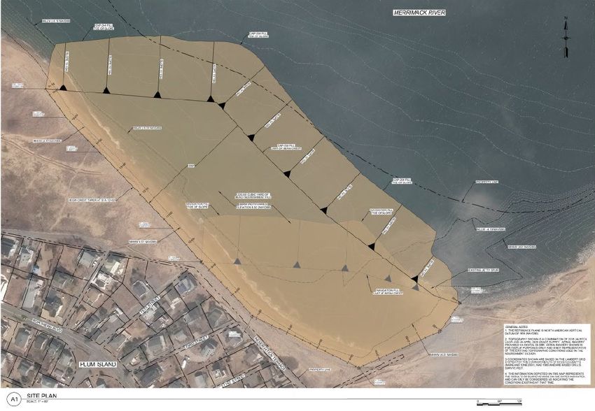
This Page Intentionally Left Blank

      Back of Front Cover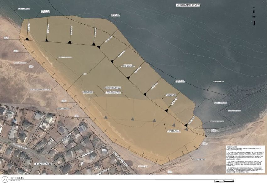
NEWBURYPORT HARBOR
     PLUM ISLAND NORTH POINT
   NEWBURYPORT, MASSACHUSETTS

BENEFICIAL USE OF DREDGED MATERIALS

     DETAILED PROJECT REPORT
               AND
    ENVIRONMENTAL ASSESSMENT

            JANUARY 2021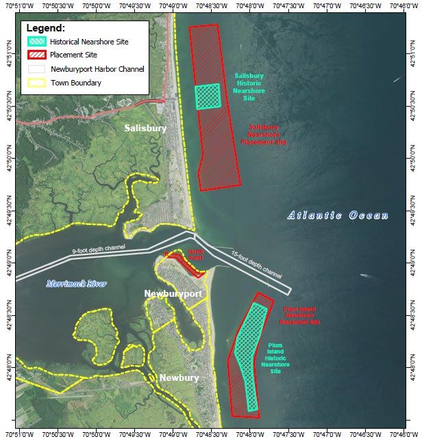
This Page Intentionally Left Blank
EXECUTIVE SUMMARY

This Study investigated the beneficial use of dredged material from maintenance of the
Federal Navigation Project (FNP) for Newburyport Harbor as beach nourishment placed
directly on the North Point of Plum Island in the City of Newburyport. This study was
authorized by Section 204 of the Water Resources Development Act (WRDA) of 1992 (33
USC Sec. 2326), as amended. The study was conducted in partnership with the City of
Newburyport and the Massachusetts Department of Conservation and Recreation (DCR).
The remaining areas of beach and dunes at North Point are within the DCR’s North Point
State Reservation on the south shore of the Merrimack River inlet and are is administered by
the Salisbury Beach State Reservation located on the north side of the inlet. The city of
Newburyport operates the North Point Reservation under agreement with the State.

Plum Island is a barrier island with the Atlantic Ocean to the east and extensive salt marsh to
the west between the island and the mainland. Plum Island is located about 32 miles north
of Boston. The northern end of the Island is primarily a residential area split between the
town of Newbury and the city of Newburyport. The southern areas of the Island in the
towns of Newbury, Rowley and Ipswich are part of the Parker River National Wildlife
Refuge, with a State Park located at the south end of the island. Plum Island is separated
from Salisbury Beach to the North by the Merrimack River inlet including the Federal
Navigation Channel for Newburyport Harbor. Newburyport Harbor has been maintained by
the Federal government for navigation purposes since the early 1800s. Federal maintenance
of the navigation channels is carried out periodically with the dredged sand placed by
hopper dredge, nearshore of the beaches in Plum Island and Salisbury on either side of the
inlet. Plum Island located south of the mouth of the Merrimack River, the entrance to
Newburyport Harbor, has sustained coastal storm damages and has experienced localized,
acute, erosion rates along the beach face on the southern shore within the inlet. The annual
coastal erosion rate at the site has been estimated at about 53 feet per year at Newburyport,
far in excess of the long-term average for this region.

The town of Newbury, city of Newburyport, and town of Salisbury have all expressed their
concern and interest to develop long term solutions to their erosion problems. The
maintenance of the Newburyport entrance and inner channels provides an opportunity for
near-term relief to the current most critically at-risk properties, which are located at North
Point in Newburyport. The study area and recommended plan are shown in Figure ES-1.

Historically, the Federal Base Plan for maintenance dredging of Newburyport Harbor FNP,
as followed for the past several maintenance cycles, has involved maintenance by a mid-size
hopper dredge with placement of the material in designated nearshore bars (15 to 30 foot-
water depth) adjacent to the beaches in Salisbury and Newburyport. Placement of the
material in the nearshore site has enabled the material to remain in the littoral system of the
beaches and be available for natural re-building of the beaches.

North Point, Plum Island, Newburyport, MA                                  Executive Summary
§204 Beneficial Use of Dredged Materials ES-1                       Draft DPR - January 2021
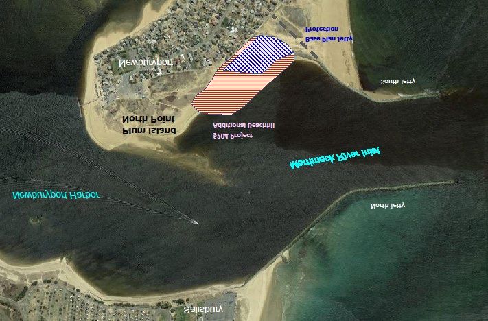
The upcoming maintenance dredging planned for the 2021-2022 construction season entails
about 220,000 cubic yards (CY) of material to be removed from the 15-foot channel
including required material and a 2-foot overdepth allowance, and from the 9-foot inner
harbor channel, with a 1-foot allowable overdepth. Unlike previous dredging events, a
portion of the material will be used as beach placement at North Point, while the remainder
will go to the previously used nearshore placement sites. Recent severe erosion at North
Point also extended easterly towards the shore arm of the south jetty, a feature of the FNP.
A short stone spur on the upstream side of the south jetty which was constructed in 1970 to
prevent flanking of the jetty, has itself been flanked by the erosion. As part of the Federal
Base Plan the maintenance operation includes using about 57,000 cubic yards of the dredged
material to fill-in the eroded area behind the spur jetty to address the issues with long-term
stability of the south jetty. That remainder of the dredged material, about 163,000 CY,
would go to the previously used nearshore placement sites as beneficial use.

Under the Section 204 project all of the dredged maintenance material, 220,000 cy, would
be placed as beachfill on North Point, including the area west of the spur jetty placement
site. The additional sand would increase the elevation and width of the beach berm and
extend it to the west in front of the threatened homes along Reservation Terrace. The
section of the fill would vary along the beachfill area, with a greater volume placed to the
south end of the area where erosion has been most severe. The beachfill area is about 900
feet long by 350 feet wide and is located west of the South Jetty and would receive all
220,000 CY of the sandy dredge material. This area includes about 68 shorefront lots that

North Point, Plum Island, Newburyport, MA                                 Executive Summary
§204 Beneficial Use of Dredged Materials ES-2                      Draft DPR - January 2021
could experience damage or loss during the 2022-2032 period. Detail on the placement
areas on North Point is shown in Figure ES-2.

Figure ES-2 – Beachfill Placement for the Spur Jetty Protection Base Plan          and
the Section 204 Expanded Beachfill Placement         .

Dredging would be accomplished by either a hopper dredge with direct pump-off capability
that would discharge into a line moored offshore of the beaches to be filled, or by a
hydraulic pipeline dredge that would pump the material from the channel through a
discharge pipe.

An Environmental Assessment, Finding of No Significant Impact, and Clean Water Act
Section 404(b)(1) Evaluation were prepared for the Section 204 beneficial use features and
is included with this Detailed Project Report. Construction windows have been established
in coordination with Federal and State agencies for protection of aquatic resources (channel
dredging) and nesting shorebirds (on-beach placement). The project construction would be
conducted within the following timeframes:

  • Dredging Activities (by location):
    o 15-Foot Entrance Channel: All year (no timeframe restriction).
    o 9-Foot Inner Harbor Channel: 1 July to 14 February (no dredging from 15 February
      to 30 June).

North Point, Plum Island, Newburyport, MA                                Executive Summary
§204 Beneficial Use of Dredged Materials ES-3                     Draft DPR - January 2021
• Placement Activities (by location):
o Nearshore Placement: All year (no timeframe restriction)
o On-Beach Placement at North Point: 1 September to 31 March (no on-beach
placement from 1 April to 31 August)
The constructed on-beach berm at North Point will not exceed a slope of 1V:10H to ensure
the shoreline functions as habitat for foraging shorebirds after project completion. With the
implementation of the proposed construction windows and regulating the slope of the on-
beach berm design, no unavoidable or significant environmental impacts are anticipated for
this project.
Costs for the Section 204 beneficial use project are measured as the increase in cost for
direct placement of all of the dredged sand on the North Point Beaches above the cost of the
Federal Base Plan for placement of most of the material in the nearshore bars off the
beaches and only some of the material on North Point behind the spur jetty. The increased
cost for construction of the beach nourishment plan is estimated at $497,600. The 35
percent non-Federal share of the §204 project is estimated at $173,950. The 65 percent
Federal share would be $323,050.
The purpose of the Section 204 project, and the benefits produced are solely for storm
damage reduction. Benefits for the increased beachfill include delaying the loss and damage
of the protected properties for the lifespan of the beachfill. The lifespan of the beachfill is
estimated at 3-4 years for Plum Island. All the properties to be protected are private parcels
currently developed for residential use. The estimated benefits of the project include delays
in damages to structures, value of land lost, and repairs and replacement of damaged utilities
that serve the properties subject to damage. Incidental recreation benefits would also be
realized. The incremental construction cost of beach nourishment is $497,000 or $57,600
when annualized over the 10-year period of analysis used for North Point (Table ES-1). Net
annual benefits amount to $1,455,900 yielding a Benefit to Cost Ratio of 26.3 to one. These
benefits indicate a positive National Economic Development plan for beneficial use of
dredged material to provide coastal storm damage risk reduction in the city of Newburyport,
Massachusetts.
The analysis indicates that nourishment North Point Beach is feasible, environmentally
acceptable, and economically justified. This report concludes that there is Federal interest in
proceeding with implementation of a project for the beneficial use of dredged material from
Newburyport Harbor under the authority of Section 204 of the Water Resources
Development Act of 1992 (33 USC Sec. 2326), as amended, in accordance with the
Recommended Plan identified in this Detailed Project Report, with such further
modifications thereto as in the discretion of the Chief of Engineers may be advisable.
North Point, Plum Island, Newburyport, MA Executive Summary
§204 Beneficial Use of Dredged Materials ES-4 Draft DPR - January 2021Table ES-1
Newburyport Harbor and North Point, Plum Island, Massachusetts
Section 204 Beneficial Use of Dredged Materials Project
Projected Costs and Cost-Sharing
Dredging and Placement - Cubic Yards Base Plan CY with §204
Total Maintenance Dredging 220,000 220,000
Behind Spur Jetty - South Jetty Flank Protection 57,000 57,000
Nearshore Feeder Bars – Salisbury and Plum Island 163,000 ----
Expanded North Point Beneficial Use Placement ---- 163,000
Project First Costs (FY 2021 Price Levels) Base Plan Cost with §204
Project First Costs for Design & Construction $6,137,000 $6,619,000
Total Investment Cost (with IDC) $6,149,800 $6,653,500
Cost Difference – Cost of Section 204 Project $503,700
§204 Project Cost-Benefit Analysis (FY 2021 Price Levels)
Capital Recovery Factor – 2.5% at 10 Years 0.114259
2021 Annual Costs for 10-Year Period of Analysis $57,600
Annual Benefits for 10-Year Period of Analysis $1,513,500
Net Annual Benefits $1,455,900
Benefit Cost Ratio 26.3
Cost-Sharing – Design & Implementation (FY22) Base Plan Cost with §204
Fully Funded Project Cost (December 2021) $6,312,000 $6,809,000
Cost Difference $497,000
Federal Cost – 65% $323,050
Non-Federal Cost – 35% $173,950
Implementation of the Section 204 project requires approval of this report and the project,
securing all required Federal, State and local regulatory approvals for the modified disposal
plan, commitment of funds by the Federal Government and the non-Federal Sponsor, the
Massachusetts Department of Conservation and Recreation, execution of a Project
Partnership Agreement between the USACE and the non-Federal Sponsor, provision of all
required easements by the non-Federal Sponsor for construction and maintenance of the
beachfill and public use and access to the beaches receiving the fill, preparation of plans
and specifications, solicitation of bids, award of a contract, and completion of construction.
The recommendations contained in this report reflect the information available at this time
and current USACE Departmental policies governing formulation of individual projects.
They do not reflect program and budgeting priorities inherent in the formulation of a
national Civil Works construction program nor the perspective of higher review levels
within the Executive Branch. Consequently, the recommendations may be modified before
they are authorized for implementation funding.
North Point, Plum Island, Newburyport, MA Executive Summary
§204 Beneficial Use of Dredged Materials ES-5 Draft DPR - January 2021This Page Intentionally Left Blank North Point, Plum Island, Newburyport, MA Executive Summary §204 Beneficial Use of Dredged Materials ES-6 Draft DPR - January 2021
North Point, Plum Island, Newburyport, Massachusetts
                    §204 Beneficial Use of Dredged Material
                             Detailed Project Report

                                 Table of Contents

1   Study Information                                                                1
    1,1 Introduction                                                                 1
    1.2 Study Purpose and Authority                                                  3
    1.3 Congressional District                                                       3
    1.4 Non-Federal Sponsor                                                          3
    1.5 Purpose and Need for                                                         3
    1.6 Feasibility Study and Environmental Assessment Purpose                       3
    1.7 Study Location                                                               4
    1.8 Federal Navigation Project                                                   4
        1.8.1 Existing Navigation                                                    4
        1.8.2 Prior Studies and Reports                                              6

2   Plan Formulation                                                                 8
    2.1 Navigation Inefficiencies and Need for Project Maintenance                   8
    2.2 Planning Goals & Objectives                                                  9
    2.3 Future Without-Project Conditions                                            9
         2.3.1 Utility and Transportation Infrastructure                             9
         2.3.2 Protection of Shorefront Property                                    10
    2.4 With Project Condition (Future Beach Conditions with Federal Action)        10
    2.5 Public Involvement                                                          10
    2.6 Formulating Alternatives                                                    11
    2.7 Disposal Options                                                            11
    2.8 Dredging Methods                                                            12

3   Alternatives                                                                    13
    3.1 Federal Base Plans                                                          13
         3.1.1 No Action                                                            13
         3.1.2 Federal Base Plan – Nearshore Disposal                               14
    3.2 Beneficial Use §204                                                         15
         3.2.1 Direct Beach Placement at North Point, Plum Island – Sand Material   15

4   Existing Conditions                                                             16
    4.1 Project Area – Merrimack River Dredge                                       16
         4.1.1 General                                                              16

5   Plan Evaluation                                                                 17
    5.1 Cost Estimates for Alternative Plans                                        17
    5.2 Annual Costs                                                                18

North Point, Plum Island, Newburyport, MA                            Table of Contents
§204 Beneficial Use of Dredged Materials       i             Draft DPR – January 2021
6 Economic Analysis 19
6.1 Structural Damages and Losses Avoided 19
6.2 Land loss Avoided 20
6.3 Structure Damage Avoided 20
6.4 Utility Damage Avoided 20
6.5 Recreation Losses Avoided 20
6.6 Economic Benefit Summary 20
6.7 Benefit-Cost Analysis 21
7 Environmental Impacts 21
8 Real Estate Requirements 21
9 Cultural Resources Impacts 22
10 Selection of a Plan 22
10.1 The Selected Plan 22
10.2 Implementation Responsibilities 22
10.2.1 Cost Apportionment 22
10.3 Federal Responsibilities 23
10.4 Non-Federal Responsibilities 23
11 Conclusion 23
12 Recommendation 24
13 References 26
Appendices
Appendix A – Pertinent Correspondence
Appendix B – Coastal Engineering Report
Appendix C – Civil Engineering Report
Appendix D – Cost Estimates
Appendix E – Economic Analysis
Appendix F – Sediment Test Data and Suitability Determination
Appendix G – Essential Fish Habitat Species List
Appendix H – Real Estate Planning Report
North Point, Plum Island, Newburyport, MA Table of Contents
§204 Beneficial Use of Dredged Materials ii Draft DPR – January 2021Figures
Figure 1 North Point Placement Area and Study Location 2
Figure 2 Cyclical Beach Erosion and Accretion Pattern at Plum Island North Point 7
Figure 3 Massachusetts CZM Historic Shorelines and Shoreline Change Transects 8
Figure 4 Beachfill Placement for the Base Plan and Section 204 Project 15
Tables
Table 1 Maintenance Dredging History of Federal Entrance Channel 6
Table 2 Project Cost Estimates and Benefit-Cost Comparison – Base Plan
and Section 204 Alternative in FY21 Dollars. 18
Table 3 Project First Costs Deltas and Cost Sharing 18
Table 4 Economic Analysis – Fiscal Year 2021 Analysis 20
North Point, Plum Island, Newburyport, MA Table of Contents
§204 Beneficial Use of Dredged Materials iii Draft DPR – January 2021This Page Intentionally Left Blank North Point, Plum Island, Newburyport, MA Table of Contents §204 Beneficial Use of Dredged Materials iv Draft DPR – January 2021
North Point, Plum Island, Newburyport, Massachusetts
                      §204 Beneficial Use of Dredged Material
                               Detailed Project Report

1    Study Information
     1.1    Introduction
This Detailed Project Report and Environmental Assessment (DPR/EA) presents the results of
studies to formulate and evaluate alternatives to beneficially use dredged material from the
maintenance of the Federal Navigation Project (FNP) for Newburyport Harbor at North Point,
Plum Island, Massachusetts. The study was requested by the city of Newburyport and the
Massachusetts Department of Conservation and Recreation (DCR). Two alternatives were
evaluated: the Federal Base Plan consisting of the least costly means of project maintenance,
and beneficial use for coastal storm risk management through onshore placement on the beach
at North Point.

Plum Island is located about 32 miles north of Boston in northern Essex Count along the
State’s easterly Atlantic coast. Plum Island is a barrier island with the Atlantic Ocean to the
east and extensive salt marsh to the west between the island and the mainland. The 8.3-mile
long island lies between the Merrimack River inlet at its northern end and Ipswich Bay at its
southern end. The southern 6.3 miles of the island are within the Parker River National
Wildlife Refuge (PRNWR). The northern two miles of the Island is primarily a residential
area split between the town of Newbury to the south (1.4 miles) and the city of Newburyport
at its northern end (0.6 miles).

The project area is located along the south shore within the inlet between the inlet’s south
jetty and the shoal upstream at the old U.S. Coast Guard Station (Figure 1) within the city of
Newburyport. The study area has beachfront homes, businesses, the state park, and the old
U.S. Coast Guard station ranging from 150 – 615 feet from the water (average 355 feet). The
developed portion of the Island is bound by the Merrimack River and tidal inlet to the west
and north, Atlantic Ocean on the east, and the PRNWR to the south (Figure 1). The study
area is state land administered by the DCR and is managed by the city of Newburyport under
agreement with the Commonwealth of Massachusetts.

Plum Island is separated from Salisbury Beach to the North by the Merrimack River inlet
including the Federal Navigation Channel for Newburyport Harbor. Newburyport Harbor has
been maintained by the Federal government for navigation purposes since the early 1800s.
Federal maintenance dredging of the navigation channels is carried out periodically with the
sandy dredge material placed by hopper dredge to nearshore placement sites off the beaches
in Plum Island and Salisbury (Figure 1).

This DPR/EA examines the potential for beneficially using a portion of the sand dredged for
maintenance of the entrance and inner harbor channels at Newburyport Harbor. The most
recent condition survey results show that the channels have shoaled to depths impeding safe
navigation with an accumulated 220,000 CY of shoal material, including allowable
overdepth. The 220,000 cubic yards of

North Point, Plum Island, Newburyport,                            Draft Detailed Project Report
MA §204 Beneficial Use of Dredged                1                                January 2021
Materials
material is clean sand and suitable for onshore placement for coastal erosion prevention. A
hopper dredge or a hydraulic pipeline dredge will perform the work and sand will be disposed
of at either of the three disposal sites: Plum Island nearshore placement site, Salisbury
nearshore placement site, or directly on the beach at Plum Island, North Point. The project
sites are shown in Figure 1. The beach placement site is a candidate for beach nourishment
under the Corps of Engineers beneficial use of dredge material program (§204) and is the
proposed alternative discussed in this report. The New England District of the Corps of
Engineers (NAE) has examined environmental resources as part of the planning and
development of the proposed work in compliance with the National Environmental Policy
Act of 1969 and appropriate Federal laws, Executive Orders and regulations. This report and
accompanying Environmental Assessment provide document investigations and evaluate
environmental impacts and alternatives considered for the proposed upcoming maintenance
dredging action.
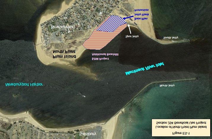
Figure 1. North Point Placement Area and Study Location
North Point, Plum Island, Newburyport, Draft Detailed Project Report
MA §204 Beneficial Use of Dredged 2 January 2021
Materials1.2 Study Purpose and Authority
The NAE received a request from the city of Newburyport, Massachusetts seeking Federal
assistance under Section 204 of the Water Resources Development Act (WRDA) of 1992.
Section 204 provides authority for USACE to plan, design, and build projects to protect,
restore and create aquatic and ecologically related habitats in connection with dredging of
authorized Federal navigation projects. Typically, Section 204 projects involve the
beneficial use of dredged material from navigation channels to improve or create wetlands or
waterbird nesting habitats, nourish beaches, or otherwise provide flood risk mitigation or
coastal storm damage reduction benefits. The local non-Federal Sponsor, the city of
Newburyport, understands and agrees with the study/project requirements, including typical
costs and cost-sharing.
Initial analysis during the Federal Interest Determination (FID) phase showed federal interest
for a beneficial use project at Plum Island for placement of material on a beach site at North
Point, Plum Island, Newburyport, Massachusetts.
1.3 Congressional Districts
The city of Newburyport is in Massachusetts U.S. District 6.
1.4 Non-Federal Sponsorship
The DCR is the non-Federal Sponsor.
1.5 Purpose and Need for the Project
The coasts of Plum Island and Salisbury Beach are experiencing severe coastal erosion. This
erosion has generated a local interest in the placement of clean, sandy dredge material on the
beaches. Suitable dredge material for this placement will be available during the next
maintenance dredging event for the Newburyport Harbor navigation channels for
Newburyport Harbor are next maintained (estimated 2020-2021). The erosion area at North
Point is approximately 2,300 feet long to the west of the South Jetty. Much of the
Reservation’s beach and dunelands fronting the inlet have been lost over the past eight years.
This leaves only a narrow buffer of remaining dune between the inlet waters and the
developed shoreline. Residential and commercial property damage and loss is likely with the
next severe winter storm or major rainfall event in the Merrimack River Basin. Plum Island
and other local beaches surrounding Newburyport Harbor have sustained coastal storm
damages and have experienced localized, acute, erosion rates along the beach face exposed to
the Atlantic Ocean. Several structures, including residences and one commercial building,
have potential for severe damages in the immediate future. Other areas of Plum Island’s
Atlantic facing shore have lost homes in the past five years.
1.6 Feasibility Study and Environmental Assessment Purpose
This integrated document serves as the USACE decision document supporting the
recommended project and as the EA to meet National Environmental Policy Act (NEPA)
requirements for the proposed action.
North Point, Plum Island, Newburyport, Draft Detailed Project Report
MA §204 Beneficial Use of Dredged 3 January 2021
MaterialsThe analysis conducted during the Feasibility Study determines if the project is warranted and
necessary and if necessary, recommend actions.
The NEPA Council on Environmental Quality (CEQ) Regulation, Section 1502.13, provides
the fundamental legal guidance on Purpose and Need statements for an EA. The Purpose and
Need statement, “shall briefly specify the underlying purpose and need to which the agency is
responding in proposing the alternatives including the proposed action.” This step in the
NEPA process mirrors a similar step in the USACE 6-step planning process, development of
problems and opportunities statements. Once the problems and opportunities are properly
defined, the next step is to define the study planning objectives and the constraints that will
guide efforts to solve these problems and achieve these opportunities. In developing a
feasibility report with integrated NEPA components, the problem and opportunities can be
used synonymously with “need” and objective and constraints can be used synonymously
with “purpose”.
1.7 Study Location
The study area is within the city of Newburyport portion of Plum Island at its northern end.
Plum Island is a barrier island with the Atlantic Ocean to the east and extensive salt marsh to
the west between the island and the mainland. Plum Island is located about 32 miles north of
Boston. The northern end of the Island is primarily a residential area split between the town
of Newbury and the city of Newburyport. The southern areas of the Island are included in a
State Park and the PRNWR located in the towns of Newbury, Rowley and Ipswich. Plum
Island is separated from Salisbury Beach to the North by the Merrimack River inlet including
the Federal Navigation Channel for Newburyport Harbor and the inner channel.
Newburyport Harbor has been maintained by the Federal government for navigation
purposes since the early 1800s. Federal maintenance of the navigation channels is carried out
periodically with the dredged sand placed by hopper dredge, nearshore of the beaches in
Plum Island and Salisbury on either side of the inlet.
The project’s non-Federal Sponsor, the DCR and the city of Newburyport requested that the
USACE investigate beneficial use of sand as beachfill at North Point due to the severity of
the recent erosion in that area. The project area is located between the inlet’s south jetty (to
the east) and the point and shoal at the old Coast Guard Station (Figure 1) upstream within
the city of Newburyport. The study area has beachfront homes, businesses, the state park, and
the old U.S. Coast Guard station ranging from 150 – 615 feet from the water (average 355
feet).
1.8 Federal Navigation Project and Prior Reports
1.8.1 Existing Navigation Projects
The Merrimack River entrance channel to Newburyport Harbor was authorized by Congress
as a FNP in 1828. Initial efforts to improve navigability in the first part of the 1800’s
included small stone jetties within the inlet, a stone filled timber crib dike was constructed
westerly from Plum Island 1,680 linear feet to Woodbridge Island and across the flats to the
west to constrain the river flow to increase inlet velocities to effect reduced shoaling of the
inlet bars. From 1881 the construction of North Jetty started and was completed in 1906; and
North Point, Plum Island, Newburyport, MA Draft Detailed Project Report
§204 Beneficial Use of Dredged Materials 4 January 2021construction of the South Jetty in from 1883 to 1906. The jetties lined both sides of the inlet
with the intention of scouring the channel to 17 feet below Mean Low Water (MLW).
Construction of the jetties, as well as sand-catch weirs and dikes landward of the southern
jetty, acted to stabilize the location of the inlet which had historically migrated south for about
a mile before reversing over a long term cycle. Following construction, repairs, extensions,
and maintenance of both jetties were completed as needed.
Newburyport Harbor FNP was last maintained in the 2010-2011 dredging season when
approximately 165,500 cubic yards (CY pay volume) were removed from the entrance
channel by hydraulic pipeline dredge and placed as nourishment on Salisbury Beach (43,000
CY) and Plum Island Center Beach in Newbury (more than 123,500 CY) as a §204 Project.
Prior to this, the channel was maintained in 1999, when approximately 145,000 cubic yards
were removed and placed at the Plum Island nearshore placement site. Typically, this
maintenance dredge material is placed nearshore as the least cost alternative, alternating
between the Plum Island and Salisbury Beach nearshore placement sites.
The existing 15-foot Federal channel is typically dredged with a 2-foot allowable overdepth to
a pay elevation of -17 feet at mean lower low water (MLLW). The inner harbor channel from
the inlet to downtown Newburyport ending at U.S. Route 1 has an authorized depth of -9 feet
MLLW and is dredged with a one-foot allowable overdepth to a pay elevation of -10 feet
MLLW. The most recent conditions survey results show that the entrance inner harbor
channels have shoaled to depths impeding safe navigation with an accumulated 220,000 CY
of material, including allowable overdepth. The 220,000 cubic yards of material are clean
sand and suitable for onshore placement for coastal erosion prevention.
The jetties were rehabilitated with the intention of reducing porosity and thus inhibiting the
flow of water and sediment through the jetties. Maintenance dredging of the federal channel
was completed in 1937-1941, 1957-1958, 1961, 1964, 1966, 1968, 1970, 1973, 1981, 1983,
1996, 1999, and 2010. In addition, construction of revetment and sand dike near the U.S.
Coast Guard Station along the south bank of the inlet in the river's mouth occurred in 1970.
Material from past maintenance dredging cycles has been placed nearshore or directly on the
eastern shores of Plum Island and Salisbury Beach.
The existing Federal projects in Newburyport Harbor, consists of:
• Two jetties, one projecting 4,118 feet from the north shore, the other projecting 2,445
feet from the south shore, converging until 1,000 feet apart.
• Entrance Channel
• Inner Harbor Channel
• Dikes in Inlet and Harbor
• Removal of ledges and large boulders in harbor
The maintenance dredging history of the 15-foot and 9-foot Federal channels at Newburyport
Harbor is summarized in Table 1. Disposal options have included offshore open water
disposal by hopper dredge, nearshore disposal by hopper dredge, or disposal adjacent to the
North Point, Plum Island, Newburyport, Draft Detailed Project Report
MA §204 Beneficial Use of Dredged 5 January 2021
Materialschannel by sidecasting dredge. Section 3, Alternatives, discusses the various nearshore and
beach disposal sites for this project.
Table 1: Maintenance Dredging History of Entrance Channel
Dredge Type/Contractor Work Dates Quantity in
Cubic Yards
(CY)
Government Hopper Dredge HYDE 26 July - 12 August 1961 250,000
Government Hopper Dredge HYDE 18 - 25 May 1964 131,000
Government Hopper Dredge LYMAN 3 - 16 May 1966 50,000
Government Hopper Dredge HYDE 2 - 13 July 1968 86,000
Contractor 20 August - 16 Oct 1970 106,190
Government Hopper Dredge HYDE 15 August - 3 September 93,650
1973
Government Hopper Dredge DAVISON 16 June - 3 July 1977 54,000
Contractor Hopper Dredge 19 June - 1 July 1981 102,600
ATCHAFALAYA
Contractor Hopper Dredge MERMENTAU 9 - 26 August 1983 123,500
Contractor Hopper Dredge July – September 1987 156,265
Government Hopper Dredge CURRITUCK June – July 1990 62,460
Contractor Hopper Dredge GULF COAST August - September 1991 135,290
TRAILING
Contractor Hopper Dredge NORTHERLY 26 - April - 10 May 1993 125,040
ISLAND
Contractor Hopper Dredge 8 – 26 September 1996 125,386
Contractor Hopper dredge 28 July – 16 August 1999 145,017
ATCHAFALAYA
Contractor Hydraulic cutter-head pipeline 16 September- 14 October 143,500
dredge Great Lakes D&D - ILLINOIS 2010
1.8.2 Prior Studies and Reports
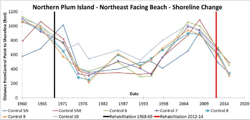
A 2018 study analyzing shoreline change on northern Plum Island was performed by
USACE’s Engineering Research and Development Center (ERDC), Coastal & Hydraulics
Laboratory at the request of NAE under the Dredging Operations Technical Support (DOTS)
program. The study examined shoreline position using historical and modern aerial and
satellite images from 1960 to 2016; aerial LIDAR flown in 2014 and 2015; and a 2016 beach
profile survey by NAE. The study concluded the northeast facing beach (North Point) along
Reservation Terrace is highly variable with regard to shoreline position and has experienced a
cyclical erosion and accretion pattern over time (Figure 2). From 1960 to 1975 the shoreline
is substantially erosional, having lost approximately 700 feet of dry beach in 15 years, with
substantial erosion occurring between 1965 and 1975. From 1975 to 1995 the shoreline is in
some level of stability, or dynamic equilibrium, with short periods of accretion and erosion of
approximately less than 200 feet of change. From 1995 to 2008, the shoreline is accretionary
having recovered some 700 feet of shoreline that was lost in the 1960s and 1970s. Sometime
between 2008 and 2012, the trend reverses and becomes erosional. Although there is
North Point, Plum Island, Newburyport, Draft Detailed Project Report
MA §204 Beneficial Use of Dredged 6 January 2021
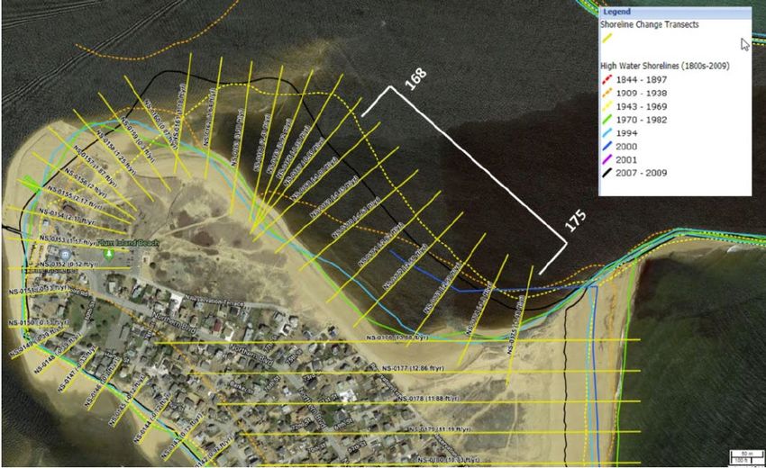
Materialsinsufficient temporal resolution to discern the beginning of erosion and accretion periods, the study estimates the northeast-facing shoreline began eroding again in 2009 or 2010. If the shoreline follows the historical, cyclical pattern observed, the northeast-facing shore can expect erosion for at least 10 years after the rehabilitation of the jetties. Figure 2. Cyclical Beach Erosion and Accretion Pattern at Plum Island North Point - From 1960-2016 (Taylor, 2018) In the study area, Massachusetts Coastal Zone Management (CZM) has historic high-water shorelines and shoreline change transects for 1909-1938, 1943-1969, 1970-1982, 1994, 2000, and 2007-2009. Figure 3 illustrates the variability in shoreline location. Long-term change is based on all available shorelines, whereas short-term change is based on shorelines between 1970 and 2009. Accretion and erosion are indicated by positive and negative values, respectively. Due to the cyclical erosion and accretion pattern described in the 2018 DOTS study and the age of the most recent shoreline position, these shoreline change rates were not considered to be reflective of the current and future short-term erosion conditions. North Point, Plum Island, Newburyport, Draft Detailed Project Report MA §204 Beneficial Use of Dredged 7 January 2021 Materials
Figure 3. Massachusetts CZM Historic Shorelines and Shoreline Change Transects.

Kraus (2008) conducted a short-term study of possible factors contributing to beach erosion
on Plum Island by the Newburyport Harbor FNP. As part of this study, Kraus reviewed the
historical impact of jetty rehabilitation and concluded that substantial erosion of the interior
beach had occurred in the 1970s immediately following the initial rehabilitation effort. In
1970, in an effort to mitigate against shore erosion at the U.S. Coast Guard Station and the
NAE undertook a contract to construct a sand dike and riprap shore protection along the
northern Plum Island beach. This sand dike was constructed to an elevation of +22.5 feet
MLW, well in excess of the tide range and wave run-up. While there have been a few local
attempts by the Commonwealth of Massachusetts and private entities at nourishment in small
quantities, USACE has not nourished the northern Plum Island beach since.

2    Plan Formulation

     2.1    Navigation Inefficiencies and Need for Project Maintenance
Hydrographic surveys of the entrance channel are performed periodically to identify shoals in
the FNP. The shoals present a hazard to navigation and under certain tidal conditions, seas
become violent in the entrance channel. Under these conditions, vessels using the harbor are
subject to unsafe conditions which may result in hazardous situations and damages. Dredging
will restore navigability to the channel and alleviate these potentially hazardous conditions.

North Point, Plum Island, Newburyport,                            Draft Detailed Project Report
MA §204 Beneficial Use of Dredged               8                                 January 2021
Materials
2.2 Planning Goals & Objectives
The placement of Newburyport Harbor dredged material alternative was developed based on
meeting the following goals and objectives:
• Prevent or delay coastal erosion damages and risks to life and property at North Point
Plum Island, including homes, commercial structures, and public infrastructure.
• Provide an economically efficient solution. The additional cost of on direct onshore
placement of the material must be outweighed by the benefits of that placement.
• Provide a constructible solution. On shore placement of dredged material has many
construction related challenges due to equipment availability and wave and tide
activity.
• Provide an environmentally acceptable solution with minimized impacts to shoreline
as regulated by Massachusetts Coastal Zone Management.
2.3 Future Without-Project Conditions
Future without-project conditions forecast the conditions expected during the period of
analysis if no beneficial use beachfill project is constructed. The future without project
condition also provides the basis from which alternative plans are formulated and damages are
assessed. This study will forecast the conditions expected at Plum Island Beach in
Newburyport over the next ten years if no material is placed directly onshore following
maintenance dredging expected in the 2021-2022 dredging season. Specifically the analysis
will evaluate what structures and/or other infrastructure will be affected by coastal erosion
damages and when, over the ten year period, assuming the erosion rate will not change over
that time. Historic shoreline erosion rates were used to project the future condition of the
beach.
Without this project, the beach area will not be restored to contribute to the functioning,
health, and resiliency of the Plum Island community. This alternative would take no further
action. Without dredging, this would allow the shoaling to remain, along with extremely
hazardous conditions. Without the beneficial use of the North Point beach site, homes,
businesses, and critical infrastructure are at risk for total loss or increase in damage potential.
The severe erosion experienced along Reservation Terrace, North Point beaches, was
estimated at an annual rate of 53 feet per year verified against the latest survey. Plum Island
were surveyed by USACE in 2019, providing a detailed and accurate topographic map of the
dry beach and dunes. Details of these surveys and the resulting retreat calculations are
provided in Appendix B - Coastal Engineering.
2.3.1 Utility and Transportation Infrastructure
Northern Boulevard provides access to the Plum Island Turnpike, which is the only access for
vehicles traveling to and from Plum Island. Flooding and associated damage to Northern
Boulevard could isolate a portion of the population living in the northern part of Plum Island
in the Newbury and Newburyport sections. In addition, although outside of the study area,
damage to Plum Island Turnpike, or the bridge and causeway, could have direct effects on the
study area with isolation of portions of the island not evacuated prior to a storm event.
North Point, Plum Island, Newburyport, Draft Detailed Project Report
MA §204 Beneficial Use of Dredged 9 January 2021
MaterialsUtilities would also be in jeopardy from severe over wash events or a collapse of the road. If
long term erosion is left to continue, it could eventually undermine Northern Boulevard and
expose water and sewer lines causing damage to those systems requiring their shutdown for
an extended period for repair, cleaning and rehabilitation to remove infiltrated seawater and
return the system to service. At an extreme, infiltration of seawater into the Newburyport
sewer system as far as the treatment plant could have substantial impact on City service
beyond Plum Island. Even undamaged properties may need to be temporarily abandoned
until service could be restored. It is likely that the town of Newbury and the city of
Newburyport will expend funds to prevent damage from occurring to major island roads.
Placement of dredge material at North Point will delay the future expenditure of these funds
by protecting the major roadways and utilities.
2.3.2 Protection of Shorefront Property
Shorefront properties, mainly private residences, occupy the frontal dunes in the areas
exposed to severe erosion alongside Reservation Terrace, North Point Plum Island. In the
without project condition these properties would continue to be at severe risk as the beach
retreats shoreward. These losses will continue without measures to restore and maintain the
beach system in North Point Beach area.
2.4 With Project Condition (Future Beach Conditions with Federal Action)
Future with project conditions forecasts the most likely conditions expected during the period
of analysis if the selected beneficial-use project, direct placement of sand at North Point is
constructed. The future with project condition provides the basis from which benefits
resulting from the construction project are calculated. The primary account used to calculate
benefits from a storm damage reduction project is national economic development (NED).
This study forecasts the conditions expected on Plum Island North Point over the next 10
years if the 220,000 cubic yards of available material is placed directly onshore, rather than in
the nearshore bar system, during the upcoming maintenance dredging of Newburyport
Harbor, expected to occur in 2021-2022. Specifically, the analysis will evaluate how the
project will either prevent or delay coastal erosion damages to structures and infrastructure
over the ten-year (2022-2032) period of analysis, assuming the erosion rate will not change
over that time.
2.5 Public Involvement
The project area falls within the geographical area that is the focus of the Merrimack River
Beach Alliance (MRBA). The MRBA is a group of elected officials, organizations, agencies,
municipalities, and the public, that began meeting in 2000 to discuss ways of building a
relationship with partners and the community while addressing the erosion issues within the
municipalities Newburyport, Newbury, and Salisbury. The Alliance’s efforts for stewardship
includes ways to develop and implement increases in public awareness of this unique habitat
and expand the number of citizens, businesses, educators, local officials, politicians, and
others who will support the environmental stewardship initiative for making the Merrimack
River area beaches sustainable.
North Point, Plum Island, Newburyport, Draft Detailed Project Report
MA §204 Beneficial Use of Dredged 10 January 2021
MaterialsA Merrimack River maintenance dredging meeting was held in August 2016 followed by the
USACE §204 town meeting in July 2016 then a field reconnaissance and site visit on August
2018.
2.6 Formulating Alternatives
The alternatives were developed based on meeting the goals and objectives, as analyzed for
the ten-year period of analysis (2022-2032).
The NAE is proposing to dredge approximately 220,000 cubic yards (CY) of sandy material
from shoaled areas within the Newburyport Harbor FNP. A hydraulic dredge or hopper
dredge, potentially with pump-off capability will be used. This entrance and harbor channels
will be dredged to the authorized project depth plus a possible 1 foot of allowable overdepth.
The Federal Navigation Channel was last maintained in the 2010-2011 dredging season when
approximately 165,500 cubic yards (CY) were removed from the channel by hydraulic
pipeline dredge and placed as nourishment on Salisbury Beach (43,000 CY) and Plum Island
Center Beach in Newbury (more than 123,500 CY) as a §204 Project. The beach areas
nourished in the 2010-2011 project are located about one mile south and north of the beach
areas currently being considered and in different municipalities.
Three alternatives have been developed:
• No Action
• Federal Base Plan – direct beach placement to protect the spur jetty (57,000 CY) in
addition to nearshore disposal at both Salisbury and Plum Island nearshore sites
(163,000 CY)
• Direct Beach Placement of all 220,000 CY at North Point, Plum Island, of which
163,000 CY would be placed under Section 204 authority.
2.7 Disposal Options
Offshore Placement - Historically, dredged material from Newburyport Harbor was disposed
of at an offshore placement site (USACE, 1973). The 1973 Environmental Assessment
describes the location of this site as: "An area one-half nautical mile square, the sides of
which run true north and south and true east and west. The center is at a point with Black
Rock Light bearing true 289°, a distance of 3,700 yards; and Newburyport Light bearing true
272°, a distance of 3,200 yards.
Currently, it is the Corps policy to place sandy dredged material at a nearshore site in order
for the material to remain within the littoral system of the project area. Offshore placement
was therefore not considered as a preferred alternative for the dredge material from
Newburyport Harbor.
Nearshore Placement - Two nearshore placement sites were considered for this project. One
area is located adjacent to Plum Island Beach and the second adjacent to Salisbury Beach.
Both sites has been successfully used in the past for placement of sandy dredged material.
Investigation of sediment transport patterns along the Plum Island - Salisbury Beach system
North Point, Plum Island, Newburyport, Draft Detailed Project Report
MA §204 Beneficial Use of Dredged 11 January 2021
Materialsand coordination with the applicable resource agencies indicates that the placement of the
sandy dredged material in the nearshore areas would keep the material within the littoral drift
system. Nearshore placement will make material available for movement onto the adjacent
beaches.
Upland Disposal - The material to be dredged is clean sand that is an important component of
the Plum Island-Salisbury Beach system and considered a valuable resource, therefore the
removal of this material from the system is deemed unacceptable. Upland disposal was not
considered as a preferred alternative for the disposal of material from Newburyport Harbor.
Beach Renourishment – North Point, Newburyport, beach site was evaluated for sand
placement. The area was identified and selected sites for sand placement based on the need to
alleviate severe beach erosion. The placement of the sandy dredge material on adjacent
beaches is considered a practice of beneficial use. The placement of the material on the
selected beach sites is considered practical and therefore retained as a possible beneficial re-
use alternative.
Beach Renourishment to Protect the Spur Jetty – The landside area behind the spur jetty
located adjacent to the North Jetty on North Point, Newburyport, was evaluated for sand
placement. Protecting this USACE structure is crucial to the overall system. The area was
identified and selected for sand placement based on the need to alleviate severe beach erosion
that could compromise the spur jetty structure. The placement of the sandy dredge material is
considered a practice of beneficial use. The placement of the material on the selected area of
the beach is considered practical and therefore retained as a possible disposal beneficial re-use
alternative.
2.8 Dredging Methods
There are a number of dredging methods that could be employed at Newburyport Harbor.
Below are the dredge options that could work at Newburyport Harbor:
• Large Hydraulic Pipeline Dredge: A hydraulic pipeline dredge remains stationary
while it pumps the material through a pipeline to the disposal area. These dredges
typically have pump and pipeline diameters of 20 to 30 inches or more and have a
much larger dredge hull and much more robust anchoring systems that could be
operated stably in the sea conditions of the Newburyport entrance. A pipeline would
extend from the working dredge into the inlet to the shore end of the jetties, where it
would cross the jetty and transition to a land line extending along the beaches to the
discharge area. An A-frame barge would be used to position the floating pipe in the
inlet. Heavy equipment such as a small dozer would be used to lay and extend the
pipe on the beach, form toe dikes along the discharge area to minimize loss of beach-
fill material to the surf, and to spread and grade the material to the finished elevations
and slopes.
• Mechanical Bucket Dredge: A mechanical dredge operates from a stationary position
while removing the material with a clamshell bucket and loading it into scows which
transport it to the disposal site. A mechanical dredge utilizing scows to transport and
dispose of material for use in nearshore disposal would be able to effectively dredge
North Point, Plum Island, Newburyport, Draft Detailed Project Report
MA §204 Beneficial Use of Dredged 12 January 2021
Materialsthe project area. However, such a dredge plant could not directly place the material on
the beaches and would only be used if the nearshore disposal sites were the preferred
plan.
• Small Split-Hull Hopper Dredge: A hopper dredge moves through the dredging
area, removing the material from the bottom and pumping it into the hopper. When
the hopper is full the dredge proceeds to the disposal site and empties the material
through bottom opening doors. A hopper dredge would be an effective dredging
method in the Merrimack River. Historically, maintenance dredging of the entrance
channel has been performed by small class, self-propelled hopper dredges. Hopper
dredges are less subject to damage from wave action and have little impact on vessel
traffic because they dredge while underway, and do not employ anchoring devices
while working in the channel. A small hopper dredge using split hull discharge could
be used if the preferred disposal plan involved use of the nearshore sites offshore of
the beaches.
• Large Pump-Off Hopper Dredge: For hopper dredging with direct placement on the
beaches a large-class hopper dredge with onboard pump-off capability would be
required. A pump-off configured hopper dredge removes the material in the manner
of a typical hopper dredge, but has the ability to pump the material ashore by
connecting to a pipeline anchored off the receiving beach. These vessels are larger
than those typically used to working in New England waters. Using this method, a
pipeline would be placed along the beach through the beach-fill areas with a branch
leading offshore to a moored or barge-mounted connection in a water depth sufficient
for the loaded hopper dredge to tie-up and connect to the discharge line.
If nearshore placement is used for disposal, the use of either a small hopper dredge or a
mechanical dredge is the preferred dredging method for this project. If direct beach
placement is performed as a beneficial use, then either a large pump-off hopper or a large
hydraulic pipeline dredge would be preferred.
Dredging will occur during a single three to four month period depending on the availability
of funds. This assessment shall be reviewed periodically to determine its continuing
applicability.
3 Alternatives
3.1 Federal Base Plans
3.1.1 No Action
The only alternative to maintenance dredging of the Newburyport Harbor entrance channel
and the inner channel is the No Action alternative (not maintaining the channel). This would
allow the shoaling to remain, along with extremely hazardous conditions. The fishing fleet
will suffer long term increased economic costs from delays. The businesses of party/tour boat
operators may be damaged by cancellations due to rough seas at the entrance channel,
resulting in long-term financial losses. Hazardous sea conditions near the shoaled areas will
North Point, Plum Island, Newburyport, Draft Detailed Project Report
MA §204 Beneficial Use of Dredged 13 January 2021
Materialscontinue to cause unsafe conditions and endanger small craft. Dredging will restore
navigability to the channel and alleviate these potentially hazardous conditions.
Should the maintenance dredging proceed without the beneficial use beach placement sites, it
would need to rely on the nearshore placement sites. Without the beneficial use of the North
Point beach site, homes, businesses, and critical infrastructure are at risk for total loss or
increase in damage potential.
3.1.2 Federal Base Plan – Nearshore Disposal
The Federal Base Plan for maintenance dredging of Newburyport Harbor, as practiced for the
past several decades, is dredging by either a medium-sized (~2,800 CY capacity) hopper
dredge or a mechanical bucket dredge, with disposal at the Plum Island and Salisbury
nearshore sites to keep the sand in the littoral system. The hopper dredge or dredge scows
discharge their load by opening the doors in the hopper floor or scow bins at a location
estimated to be approximately 2,500 feet from shore in 18 to 30 feet of water. Possible
consequences of the Federal Base Plan (no-action alternative) would include continued
erosion and retreat of the beaches, without a natural source of material to renourish the
adjacent beaches, resulting in greater damages to structures sooner, than if the dredged sand
were placed directly on the beach.
Two nearshore disposal sites were considered for this project. One area is located to the south
of the project adjacent to Plum Island Beach and the second being adjacent to Salisbury Beach
(Figure 1). Investigation of sediment transport patterns along the Plum Island - Salisbury
Beach system and coordination with the applicable resource agencies indicates that the
placement of the sandy dredged material in the nearshore areas would keep the material
within the littoral drift system. Nearshore placement will make material available for
movement onto the adjacent beaches. In addition to the nearshore placement sites, 57,000 CY
of dredge material will be placed along the south jetty spur to protect the structure from
additional erosion that could compromise the system.
• Adjacent to Plum Island: The Plum Island nearshore disposal site is 1.5 nautical miles
long and is east of Plum Island Beach. This site has been successfully used in the past
for disposal of dredged material. This site is located directly offshore of a severely
eroding beach area.
• Adjacent to Salisbury Beach: This disposal area is located to the north of the dredge
project, adjacent to Salisbury Beach and has been used historically for disposal of the
sandy dredge material. While Salisbury Beach is showing signs of eroding, the
erosion rate is more significant at the Plum Island Beach site.
This alternative also combines the protection of the USACE owned spur jetty that is
currently at risk due to erosion. In order to determine the effect of a beach placement
of dredged material, a cross sectional beach fill construction design must be
determined appropriate for the topography, local coastal processes, amount of material
available for placement, and the length of beach to be protected. USACE LIDAR and
survey data was used to develop cross sections of the beaches at various locations
along the study area. Details on these cross sections can be found in Appendix B.
North Point, Plum Island, Newburyport, Draft Detailed Project Report
MA §204 Beneficial Use of Dredged 14 January 2021
MaterialsApproximately 57,000 CY of material is needed to protect the spur jetty and the
remaining 163,000 CY of the available 220,000 CY yards will be placed at North
Point, Plum Island beach.
• USACE Jetty Spur Protection: This alternative proposes construction of a 500-foot
long by 350-foot wide (includes taper) by beach fill project using about 57,000 CY
cubic yards of material to be dredged for maintenance of Merrimack River (Figure 4).
Construction would involve direct placement by either a self-propelled hopper dredge
with pump off capabilities or by a large hydraulic pipeline dredge. At the predicted
rates of erosion, this volume of fill would delay the structure being compromised by
approximately 2 years. Analysis of the beach fill longevity and future shoreline
position assumed the beach fill project would be constructed in 2022. Future year
conditions were projected assuming the recent average annual erosion rate of about 53
feet/year continued.
Figure 4. Beachfill Placement for the Spur Jetty Protection Base Plan and the Section 204
Project Expanded Beachfill Placement.
3.2 Beneficial Use §204
3.2.1 Direct Beach Placement at North Point, Plum Island – Sand Material
The State and municipality have requested that the dredged sand be placed directly on the
beaches, rather than in the nearshore bar system (Federal Base Plan). This would ensure that
the material would provide immediate protection to the most critical at-risk sections of Plum
Island beaches, North Point in Newburyport. In order to determine the effect of a beach
North Point, Plum Island, Newburyport, Draft Detailed Project Report
MA §204 Beneficial Use of Dredged 15 January 2021
MaterialsYou can also read