Poʻipū ROAD SAFETY AND MOBILITY PROJECT - A USDOT RAISE Application by the County of Kauaʻi, Hawai'i July 2021 - Kauai.gov
←
→
Page content transcription
If your browser does not render page correctly, please read the page content below
Poʻipū ROAD SAFETY AND MOBILITY PROJECT
A USDOT RAISE Application by the County of Kauaʻi, Hawai‘i • July 2021
OFFICE OF THE MAYOR
DEREK S.K. KAWAKAMI, MAYOR
MICHAEL A. DAHILIG, MANAGING DIRECTOR

 The Honorable Pete Buttigieg                                                                                                      July 9, 2021
 US Secretary of Transportation
 1200 New Jersey Avenue, SE
 Washington DC 20590

 Aloha Secretary Buttigieg:

 We are pleased to present this application that achieves many of the shared goals of the USDOT and the County of Kaua‘i. The
 Poʻipū Road Safety and Mobility Project will spur our economy, which has been severely impacted by COVID-19, in ways that are
 more equitable and more resilient than before. Additionally, Kaua‘i’s innovative vision for visitor transportation will become a model
 of regenerative tourism for our state and our nation. In particular, this project will accomplish the following:

  1) Reduce our impacts to Climate Change by reducing vehicle miles traveled (VMTs) and greenhouse gas (GHG) emissions through
     a focus on greater connectivity, pedestrian and bicycle mode shift, as well as locating all of these transportation and freight
     network improvements outside of our studied and identified sea level rise exposure areas.

  2) Address Racial Inequity in two census tracts (406.03 & 406.04) with high minority rates by providing substantial increases in the
     mobility opportunities for service sector employees commuting to work and children walking and biking to school.

  3) Limit Implementation Risk by ensuring virtually all the proposed work is done in previously disturbed rights-of-ways (ROW).

 The Poʻipū Road Safety and Mobility Project has emerged through extensive community input, recognizing the needs of all industries
 and stakeholders. It reflects the spirit of Kaua‘i with people of diverse interests and backgrounds, in both the public and private
 sectors, working together to achieve common goals for the benefit of everyone.

 Ho'okahi ka 'ilau like ana. Wield the paddles together.

 Derek S.K. Kawakami
 Mayor

                                   4444 Rice Street, Suite 235 • Līhu‘e, Hawai‘i 96766 • (808) 241-4900 (b) • (808) 241-6877 (f)
                                                                  An Equal Opportunity Employer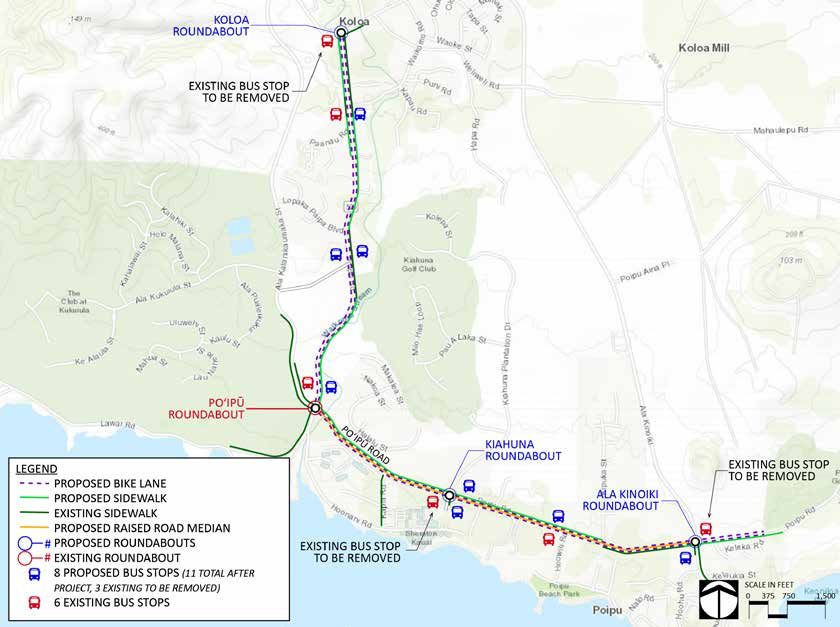
TABLE OF CONTENTS
          1 PROJECT DESCRIPTION......................................                        1   5 environmental risk......................................       25
          		INTRODUCTION...............................................                      1   		project schedule........................................       25
          		      CHALLENGES and SOLUTIONS........................                           1   		      required federal approvals.....................          25
          		      planning context and history..................                             3   		state and local approvals.......................               26
          		      statement of work.....................................                     8   		      environmental risk summary...................            27
          2          PROJECT location............................................ 12             		      state and local planning..........................       27
                                                                                                 		      assessment of project risks and
          3          grant funds, sources, and uses of
                                                                                                 		mitigation strategies.................................         27
                     project funds................................................ 16
                                                                                                 6      benefit cost analysis................................... 28
          4 selection criteria.........................................                     17
          		primary selection criteria.......................                               17
          			safety......................................................................   17          appendix a: benefit cost analysis
          			environmental sustainability...........                                        18          Submitted as a separate document.
          			quality of life..................................................              19
          			economic competitiveness.....................                                  20          Support documents
                                                                                                        Support douments such as detailed project
          			           state of good repair..................................              22          engineering plans, schedule, and cost estimate, letters
                                                                                                        of support, environmental documents, and links to
          		     secondary selection criteria...................                            23          relevant planning documents can be found at the
          			partnership........................................................            23          project website.

          			innovation............................................................         24

county of kauaʻi • 2021 raise application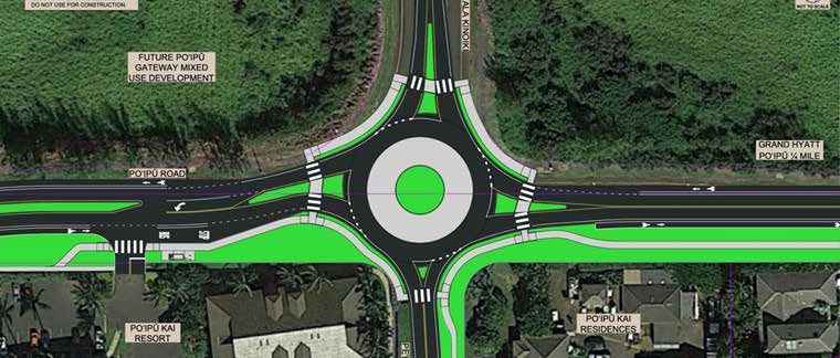
list of figures                                                    list of tables
Figure 1: home locations of south poʻipū resort workers            table 1: RECENT MULTIMODAL PROJECTS
Figure 2: Kauaʻi transit needs index                               table 2: project revenues
Figure 3: kauaʻi trips between taz groups                          table 3: project expenses
Figure 4: future poʻipū gateway development area                   table 4: project schedule
Figure 5: project overview map                                     table 5: Assessment of Project Risks and Mitigation
Figure 6: poʻipū Road Concept Plan at the intersection with                 Strategies
         Kōloa road
Figure 7: poʻipū Road Concept Plan in Kōloa Town in the vicinity
          of Kōloa Elementary School
Figure 8: poʻipū Road Concept Plan at the intersection with
          Kiahuna Plantation Drive
Figure 9: poʻipū Road Concept Plan between Hoʻowili Road and
          Kipuka Street
Figure 10: poʻipū Road Concept Plan at the intersection with
           Ala Kinoiki and Peʻe Road
Figure 11: Sample Section in poʻipū Resort area
Figure 12: Project Location
Figure 13: south kauaʻi community plan multi-modal network
Figure 14: kauaʻi shuttle concepts
Figure 15: regional freight network map

                                                                                                             Poʻipū Road Safety and Mobility Project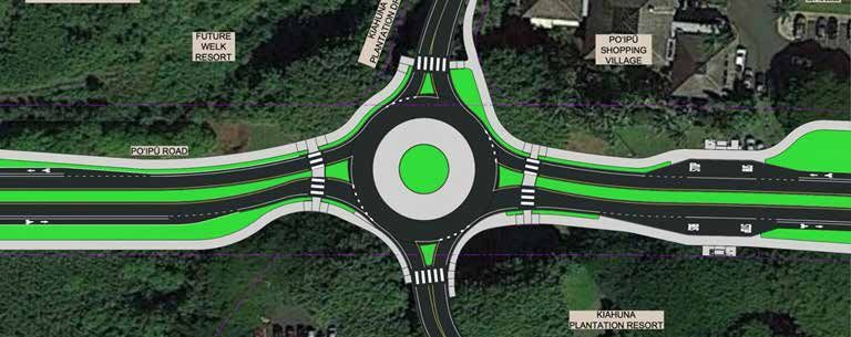
1 | project description
    Introduction                                                              As a remote island, Kauaʻi is extremely vulnerable to the impacts of
                                                                              climate change. This Project supports the County of Kauaʻi’s climate
    The County of Kauaʻi is seeking RAISE funds to construct the Poʻipū       goals by encouraging mode shift from single-occupancy vehicles to
    Road Safety and Mobility Project. Poʻipū Road is an existing road         transit, walking, and bicycling, and by creating resilient transportation
    in the south region of the island, approximately 3.3 miles long,          infrastructure outside of the projected sea level rise exposure area.
    connecting the town of Kōloa and the Poʻipū resort area. It is a
    thoroughfare serving both local and regional needs. Residential           Challenges and Solutions
    neighborhoods with affordable housing, Kōloa Elementary School, a
    public library, churches, shops and services, visitor accommodations,     Safety and Mobility
    and access to public parks and beaches are all along Poʻipū Road.
    This is a rural project with a total estimated cost of $25,192,740. The   Currently, due to vehicle speeds on Poʻipū Road and lack of
    local match is proposed to be $2,519,274, or ten percent (10%) of the     continuous sidewalks and bike lanes, it is challenging for most people
    total project cost. The RAISE grant request is for $22,673,466.           in Poʻipū or Kōloa to get to their destinations by any means other
                                                                              than driving single-occupancy vehicles. This impacts children who
    Currently, most people drive single-occupancy vehicles to access          want to walk or bike to school, adults who need to get to work, and
    jobs, education, services, and recreation along Poʻipū Road. The          families seeking recreation. According to U.S. Census data (2019
    Poʻipū Road Safety and Mobility Project (Project) will provide multi-     American Community Survey 5 Year Estimates), over 80% of workers
    modal access for underserved communities through enhanced                 in the Kōloa census-designated place (CDP) drive to work alone.
    transit, walking, and bicycling infrastructure. Kauaʻi’s most important   Traffic is congested on Poʻipū Road, especially in the vicinity of Kōloa
    economic sector, tourism, was ravaged by COVID 19, leading to             Elementary School during school pick-up and drop-off. While close
    massive job loss, affecting thousands of families on Kauaʻi. The          in distance, the housing center of Kōloa and the employment center
    Project will provide the transportation infrastructure needed to          of Poʻipū are not connected by a robust multi-modal transportation
    rebuild the tourism sector in more equitable and environmentally-         network. Two-way stops at major intersections along Poʻipū Road
    sensitive ways, and will unleash private investment for new workforce     in the resort district contribute to delay, confusion, and speeding.
    housing adjacent to the resort district. The Project will construct       Crosswalks along Poʻipū Road are not consistently well-located and
    roundabouts at three major intersections, develop continuous bicycle      vehicular travel speeds are not conducive to pedestrians safely
    lanes and sidewalks, improve pedestrian crossings, build left turn        crossing the street. In many places, residents and visitors must walk
    lanes, create 11 new or enhanced bus stops, improve drainage, and         or bike in the busy travel lanes or on inadequate grass or paved
    design landscaped medians to enhance safety and calm traffic.             shoulders.

1   county of kauaʻi • 2021 raise application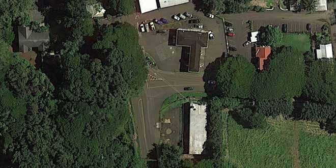
Project description

                                                               Poʻipū Road existing conditions show lack of facilities for walking, bicycling, and transit

With the Project, Poʻipū Road will be a safer street and mobility              Environmental Sustainability
choices will be enhanced. This Project will construct continuous
bicycle lanes and improved pedestrian crossings on Poʻipū                      The County of Kauaʻi is vulnerable to threats from climate change,
Road through Kōloa town, connecting neighborhoods to Kōloa                     including sea level rise, amplified flood risk due to increased storm
Elementary School, shops, and services. Within the Poʻipū resort               intensity, and disruptions to freight and supply chains. This Project
district, continuous sidewalks and bicycle lanes will better facilitate        supports the County’s climate change goals of reducing greenhouse
visitor travel between lodging and nearby shops, restaurants,                  gas emissions through mode shift and supports resiliency by
beaches, and services. For employees, improved pedestrian,                     investing in sustainable improvements to the transportation network
bicycle, and transit infrastructure will make walking, bicycling,              outside of the sea level rise exposure area.
and transit viable transportation choices. The Project includes
roundabouts at three major intersections, left turn lanes at other
                                                                               Economic Competitiveness
intersections, a landscaped median to calm traffic, and improved               Tourism is Kauaʻi’s primary economic sector, and Poʻipū is Kauaʻi’s
pedestrian crossings with median refuges and rectangular rapid                 largest resort area, serving as an economic hub and employment
flashing beacons. Overall, travel speeds will be reduced, while                center for the entire island. During 2020 and early 2021, while Kauaʻi
travel time reliability will be improved. From both mobility and               was spared many of the health impacts of COVID, its economy was
safety perspectives, all modes of transportation will be improved:             ravaged due to a near-complete lockdown on tourism. Based on
more reliability and less confusion for motorists and freight; better          data from the State of Hawaiʻi Department of Labor and Industrial
connectivity for bicyclists and pedestrians; and improved transit              Relations, in April 2019, Kauaʻi enjoyed a 2.3% unemployment
access for both visitors and employees.                                        rate. During the peak of COVID restrictions in April 2020, Kauaʻi’s

                                                                                                                          Poʻipū Road Safety and Mobility Project        2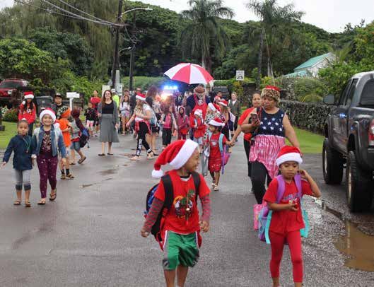
unemployment rate was 32%, one of the highest in the nation. In          implement several planning documents, including the County of
    April 2021, Kauaʻis unemployment rate stood at 12.7%. Investment         Kauaʻi General Plan (2018), the South Kauaʻi Community Plan (2015),
    that makes it easier for visitor sector employees to get to work         the County of Kauaʻi Short Range Transit Plan (2018), the Hawaiʻi
    without the expense of a private automobile will help the residents      Statewide Freight Plan (2018), and the Kauaʻi Tourism Strategic
    of Kauaʻi recover economically by reducing personal transportation       Plan (2019). From a regional transportation perspective, it is a key
    costs. At the same time, transportation network enhancements that        component of a transportation and freight network connecting the
    make it easier for visitors to get around without a car will generally   employment and resort centers of South Kauaʻi to the island’s main
    support the tourism sector of the economy and reduce the impact          airport and harbor in Līhuʻe to the east. It complements other in-
    of tourism on local residents. The Project will also establish the       progress or recently completed projects to improve the movement of
    transportation infrastructure to attract private investment in new       people and goods along this regional transportation corridor.
    workforce housing adjacent to the resort area as envisioned in
    County plans.                                                            The vision for the Project first emerged through an intense week-
                                                                             long community design charrette held in 2013. Over 200 people
                                                                             participated in the charrette, which was co-sponsored by the County
    Planning Context and History                                             and Get Fit Kauaʻi. The design charrette was led by nationally-known
    The Project concept was developed through a robust community             consultants Dan Burden and Michael Moule. An extensive outreach
    design effort that began in 2013. Environmental justice, equity,         effort led to diverse participation, including Kōloa and Poʻipū
    and climate change have been key considerations throughout               residents, workers, school and public safety officials, and property
    the planning process. The Project is consistent with and helps to        and business owners.

                                                                              The 2013 Poʻipū Road design charrette reflects community diversity

3   county of kauaʻi • 2021 raise application
Project description

Environmental Justice                                                     public, including Kāneiolouma, the Project will expand opportunities
                                                                          for cultural education while reducing the impact of automobile
Focus groups were held to assure representation from groups that          access on sensitive resources.
may not participate in traditional community meetings. These
included the Kōloa School community and the Native Hawaiian               Equity
community. For Kōloa School, important factors were reducing
school pick-up and drop-off congestion and making it safer for            The Project addresses the high cost of personal transportation for
children to walk and bike to school. These two items are inter-related:   those working in the Poʻipū resort district. Pre-COVID socio-economic
more people walking and biking to school means fewer car trips at         data shows that the largest non-government employer on Kauaʻi is
pick-up and drop-off times. The Project incorporates continuous           located in Poʻipū (Grand Hyatt Kauaʻi). Two of the top four resort
sidewalks and bicycle lanes along Poʻipū Road, better connecting          employers are found in Poʻipū (Grand Hyatt Kauaʻi and Sheraton
neighborhoods to the school. In addition, a new roundabout at the         Kauaʻi Resort). The County of Kauaʻi Short Range Transit Plan (2018)
intersection of Kōloa Road and Poʻipū Road will reduce congestion         evaluated home zip code data of employees from 7 resorts in Poʻipū.
along the Poʻipū Road corridor, especially for left turn movements at     Of the 1,660 employees included in the study, 732 employees live
what is now a one-way stop-controlled T-intersection.                     in the Kōloa/Poʻipū and Līhuʻe zip code areas. The next highest
                                                                          concentration of workers is to the west in Kalāheo, Hanapēpē, and
For Native Hawaiians, protecting cultural and historic resources          Eleʻele (Figure 1). This is corroborated by an evaluation of travel
throughout the Poʻipū Road corridor was of utmost importance,             patterns between Transportation Analysis Zones (TAZ), which found
along with educating visitors on Hawaiian values and culture.             a high concentration of trips between Kōloa/Poʻipū and residential
The Poʻipū-Kōloa area is rich in Hawaiian cultural resources. An          centers including Puhi and Līhuʻe to the east, and Kalāheo/Ele’ele
archeological literature review and field inspection for the Project,     (Figure 3) to the west. A “Transit Needs Index,” taking into account
completed in April, 2021, identified numerous stories, legends,           factors such as density of low-income households, persons with
and cultural resources in Kōloa and Poʻipū near the Poʻipū Road           disabilities, seniors aged 65 and over, youth aged under 18, and
corridor. The National Historic Preservation Act of 1966, Section 106     zero-vehicle households, found that transit needs were highest in
process has identified cultural resources and the Project has been        the communities of Hanapēpē /Eleʻele, Kalāheo, Puhi, Līhuʻe, and
designed to protect these resources. These cultural resources include     Hanamāʻulu (Figure 2). This analysis highlights the importance of
remnants of an elaborate irrigation system used for cultivation of kalo   improving the transit infrastructure connecting the high employment
(taro), and numerous heiau (sacred sites). In particular, Kāneiolouma,    center of Poʻipū with high transit need residential areas where
a significant Native Hawaiian landmark containing heiau and a             many employees live. The Project improves the transit infrastructure
Hawaiian village dating back to the mid-1400s, continues to be            along Poʻipū Road, including additional bus stops, bus shelters at
restored by the community and is accessible along Poʻipū Road. With       all stops, and first-mile/last-mile connections. The improved transit
improved multi-modal access to cultural sites that are open to the        infrastructure will enable service improvements planned for in the

                                                                                                                 Poʻipū Road Safety and Mobility Project        4
FIGURE 1: home locations of south poʻipū resort workers

                                                                          FIGURE 3: kauaʻi trips between taz groups

    FIGURE 2: Kauaʻi transit needs index

                                                                                                     South Shore Resort Area

                                                South Shore Resort Area

5   county of kauaʻi • 2021 raise application
Project description
Short Range Transit Plan to be implemented, including revamped transportation system to be operated privately, including shuttles
Kōloa-Poʻipū shuttle service that better connects to mainline routes, between Poʻipū and the Līhuʻe Airport, a local shuttle between
making transit a viable choice for many resort area employees. In Kōloa and Poʻipū, car-share, and micromobility sharing. Along with
addition to the high transit need areas, those living closer to the providing the transportation infrastructure to make it viable for
employment center of Poʻipū, such as those living in affordable employees to access jobs without using a car, the Project provides the
housing in Kōloa, will be able to reduce personal transportation costs needed roadway infrastructure for this shift in visitor transportation.
by walking, biking, or taking transit to work.
The need for affordable housing for local residents is another critical
Another aspect of equity (and also related to environmental issue facing Kauaʻi. According to the General Plan (2018), the median
sustainability) is the impact of visitors on local residents, especially home price on Kauaʻi is $730,000, 44% of Kauaʻi’s residents are “cost
in the areas of traffic congestion, protection of sensitive resources, burdened” (more than 30% of household income is spent on rent or
and access to special places. Both the Short Range Transit Plan mortgage), and 45% of homes are purchased by non-local buyers.
(2018) and the Kauaʻi Tourism Strategic Plan (2019) seek to reduce In the Kōloa census-designated place, figures are similar: 18% of
some of the negative impacts of tourism by changing the model of the population lives in poverty, 42% work in a service occupation,
visitor transportation. Currently, Kauaʻi’s resident population is about and over 43% are cost burdened. (The number of cost burdened
72,000 and prior to COVID, the number of visitors exceeded 1 million households has likely increased since 2018 as the median home
per year. On any given day (pre-COVID), visitors comprise about one- sales price on Kauaʻi was $975,000 in February, 2021.) To meet
third of the island’s combined visitor and resident population. With local housing demand countywide, 9,000 additional housing units
89% of visitors choosing to rent a car at the airport for the duration are anticipated to be needed by 2035. To reduce sprawl, traffic
of their stay, visitor traffic contributes significantly to the island’s congestion, and personal transportation costs, the General Plan calls
congestion, and the number of rental cars at visitor destinations such for new homes to be placed near existing employment centers. The
as beaches and state parks stresses sensitive environmental and South Kauaʻi Community Plan calls for a new mixed-use housing
cultural resources. While visitor travel has historically centered on center, the Poʻipū Gateway, to be developed adjacent to Poʻipū
renting a car for the duration of one’s stay, the visitor travel model is Road and the resort area (Figure 4). The Poʻipū Gateway will provide
proposed to significantly shift by providing shuttles from the airport workforce housing for those working in Poʻipū and Kōloa, within
to resort areas, shuttles within resort areas, ample pedestrian/ walking and biking distance of jobs. The Poʻipū Gateway housing will
bicycle infrastructure, bike-share, and short term car rental/car- not be within the Visitor Destination Area (VDA) so that the housing
share at the resorts. This model has begun implementation on the cannot be used for short-term vacation rentals, thereby reducing the
North Shore of Kauaʻi with the launch of the North Shore Shuttle threat of residents competing for homes with non-local investors.
in 2019. The Shuttle has greatly reduced traffic and parking impact 1,100 housing units are projected to be built within the Poʻipū
on North Shore communities and on sensitive resource areas such Gateway. The Project provides the transportation infrastructure to
as Hāʻena State Park. Based on the success of the North Shore support this proposed workforce housing development along with
Shuttle, implementation plans are being developed for a South Shore proposed infill development in Kōloa.
Poʻipū Road Safety and Mobility Project 6FIGURE 4: future poʻipū gateway development area to electric vehicles. Mode shift will not happen by itself but requires
investment in both infrastructure and services to make walking,
bicycling and transit use safe, inviting, and convenient. The Project
provides the transportation infrastructure needed for mode shift
within the Poʻipū Road corridor. The improvements will also be the
catalyst for both public and private investment in enhanced mobility
services, such as expanded transit service and micromobility sharing.
Since the 2013 design charrette, the design for Poʻipū Road has
stayed remarkably close to the original concepts developed by the
community. Community support for the Project was confirmed
through the South Kauaʻi Community Plan in 2015, and then re-
confirmed through a series of stakeholder and neighborhood
meetings in Poʻipū and Kōloa in 2019 and 2020. A summary charrette
report can be found at the Project website.
Freight
Environmental Sustainability According to the Hawaiʻi Statewide Freight Plan (2018), Poʻipū
Road is a critical component of a regional transportation network to
Addressing climate change is a top priority for the County and is
move goods to Kōloa and Poʻipū from the main airport of Līhuʻe, the
reflected in the award-winning Kauaʻi County General Plan (2018).
main harbor of Nāwiliwili, and the main town of Līhuʻe where most
In alignment with Hawaiʻi State law SB 559 and Hawaiʻi’s pledge to
commercial and industrial uses are located.
the United States Climate Alliance to achieve the goals of the Paris
Climate Agreement, the General Plan sets the goal of reducing From a system preservation perspective, as a part of Kauaʻi’s rural
Kauaʻi’s greenhouse gas emissions by 80% of 2005 levels by 2050. freight network, all of the roads connecting Poʻipū and Kōloa to
As noted in the General Plan, “achieving an 80% reduction in carbon the main airport, harbor, and industrial areas in Līhuʻe have been
dioxide emissions will require a wholesale transformation of our improved in recent years through resurfacing or reconstruction
electricity and transportation systems…” (page 188). According to projects except for Poʻipū Road. Poʻipū Road is the last link needing
the General Plan, 50% of greenhouse gas emissions in Hawaiʻi come resurfacing/reconstruction to complete this freight network. See
from the transportation sector (land, air, and marine transportation page 22 for a map showing the freight connection between Poʻipū
combined). While it has limited jurisdiction for air and marine and Līhuʻe.
transportation, the County has set ambitious goals to reduce carbon
emissions in land transportation, through mode shift and transition
7 county of kauaʻi • 2021 raise applicationProject description
Statement of Work
The Project includes the following improvements. 30% engineering plans may be found at the Project website.
• Roadway resurfacing, reconstruction, or construction of new roadway along the entire length of the Project, approximately 3.3 miles.
• Continuous sidewalks along both sides of the street for 1.5 miles, and a sidewalk on one side of the street for 1.25 miles.
• Three new roundabouts at the intersections of Poʻipū Road with Kōloa Road, Poʻipū Road with Kiahuna Plantation Drive, and Poʻipū Road
with Ala Kinoiki and Pe‘e Road. The latter two roundabouts will each include four crosswalks with median refuges. The roundabout at Kōloa
Road will include two crosswalks.
• Left turn lanes at all other intersections and driveways along Poʻipū Road between Lāwaʻi Road and Ala Kinoiki.
• Construction of paved shoulders to be marked as bike lanes, with buffers from motor vehicle traffic for the 1.5 miles of roadway where
adequate right-of-way exists.
• 11 crosswalks at uncontrolled locations with rectangular rapid flashing beacons; 5 of the crosswalks will have median refuges.
• 11 bus stops with bus shelters and amenities such as trash receptacles and bike racks; 7 of the bus stops will have bus turnouts.
• Drainage and swale improvements
• Medians for approximately 1.15 miles
• On-street parking improvements at select locations
• Landscape planting and irrigation
• Relocation of utilities as needed
• Relocation of private signage at Kiahuna Plantation Drive
• Striping and signage
All roadway features, including roundabouts, will be designed to accommodate transit and freight vehicles. The design vehicle for roundabout
turning movements (using a truck apron) is the WB-50 vehicle. The posted speed limit is 25 mph.
Figures 5 through 10 provide a graphic overview of the Project and illustrate typical Project segments.
Poʻipū Road Safety and Mobility Project 8FIGURE 5: project overview map
figure 6
figure 7
figure 8
figure 9
figure 10
9 county of kauaʻi • 2021 raise applicationPO'IPŪ ROAD SAFETY AND
MOBILITY PROJECT
NOTE:
THIS DRAWING IS FOR N
ILLUSTRATIVE PURPOSES ONLY.
DO NOT USE FOR CONSTRUCTION.
Project description
NOT TO SCALE
TEXECO GAS
FIGURE 6: poʻipū Road Concept Plan at
STATION
the intersection with Kōloa road
PO‘IPŪ ROAD
KOLO
A ROA
D
HAWAIIAN
TELCOM
FIGURE 7: poʻipū Road Concept Plan in
Kōloa Town in the vicinity of Kōloa
KŌLOA ROAD Elementary School
FIGURE
ROUNDABOUT
FIGURE 8: poʻipū Road Concept Plan
at the intersection with Kiahuna
Plantation Drive
Poʻipū Road Safety and Mobility Project 10FIGURE 9: poʻipū Road Concept Plan
between Hoʻowili Road and Kipuka
Street
FIGURE 10: poʻipū Road Concept Plan at
the intersection with Ala Kinoiki and
Peʻe Road
FIGURE 11: Sample Section in Poipu Resort area
11 county of kauaʻi • 2021 raise applicationproject location
2 | project location
The Project is located within the State of Hawaiʻi, County of Kauaʻi, the Project does address the needs of underserved communities
in the South Kauaʻi Planning District. It begins in the town of Kōloa as described in the Quality of Life section of the Primary Selection
and ends in the resort district of Poʻipū. Kauaʻi County is the local Criteria (Part 4, page 19). The Project centerline begins at
jurisdiction; there are no incorporated cities or towns within the N21°54’13” W159°28’ and ends at N21°52’35.7” W159°26’29”. A
County. The Project is not within a census-designated urbanized Project overview map is found on page 9 of this narrative. A regional
area. While it is not in an Area of Persistent Poverty as defined by map showing Poʻipū Road in relation to the freight network is found
U.S. Department of Transportation, nor does it benefit such an area, on page 22.
FIGURE 12: project location
KAUAʻI
OʻAHU
MOLOKAʻI
LANAI MAUI
HAWAIʻI
ISLAND
Poʻipū Road Safety and Mobility Project 12Connections to existing transportation infrastructure network serving walking, biking, transit, autos, and freight. Several
transportation projects have recently been completed or are in
The South Kauaʻi Community Plan and the Short Range Transit Plan progress to serve these modes.
show Poʻipū Road as part of an integrated multi-modal transportation
FIGURE 13: south kauaʻi community plan multi-modal network
13 county of kauaʻi • 2021 raise applicationproject location
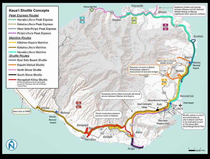
FIGURE 14: kauaʻi shuttle concepts
Poʻipū Road Safety and Mobility Project 14TABLE 1: RECENT MULTI-MODAL PROJECTS
project status
bicycle/pedestrian
Addition of sidewalks and striped shoulders on numerous local roads in Poʻipū In design
Safe Routes to School Improvements on Paʻanau Road and Poʻipū Road fronting Kōloa Elementary School Will be under construction by
September 2021
Widened shoulders on Kōloa Road and Maluhia Road Completed
Addition of sidewalks in Kōloa Town Completed
Installation of 6 rectangular rapid flashing beacon crosswalks at 6 locations in Kōloa and Poʻipū In progress – 4 of 6 installed
transit
ADA-compliant bus shelters and pads constructed at bus stops island wide (not including Poʻipū Road) Completed
Numerous service improvements added, including Wi-Fi service on buses, increased frequency of Completed
mainline service, and real-time tracking of buses on Google Transit.
aut0/freight
Resurfacing of Kōloa Road and Maluhia Road Completed
Resurfacing of Ala Kinoiki Completed
Roundabout at the intersection of Kōloa Road and Ala Kalanikaumaka Under construction
Completion of Lopaka Paipa Blvd as a through street connecting Poʻipū Road and Ala Kalanikaumaka Completed
Resurfacing of Kaumualiʻi Highway Completed
Resurfacing of numerous local streets in South Kauaʻi Completed
15 county of kauaʻi • 2021 raise applicationGrant funds, sources, and uses of project funds
3 | GRANT FUNDS, SOURCES, AND USES OF
PROJECT FUNDS
The total Project cost is estimated at $25,192,740. This includes million annually. The GET transportation surcharge funds are used for
all construction items, project mobilization, a five percent (5%) maintenance and resurfacing of County roads and bridges that are
construction contingency, and construction management/ not eligible for Federal Aid, operation of our local transit system, and
engineering support during bidding and construction. RAISE funds as a local match for Federally funded transportation projects. There
of $22,673,466 are requested toward these costs. A ten percent are no restrictions as to when or how these local funds are spent in
(10%) local match of $2,519,274 in County funds will be used for relation to this Project. The match amount and funding sources have
this Project. The sources of these local funds include $341,566 in been approved by County Council. The County has sufficient funds
Capital Improvement Program (CIP) funds and $2,177,708 from the and successful experience with Federal-Aid projects to operate on a
County’s General Excise Tax (GET) transportation surcharge. The reimbursement basis for the Federal share of the Project.
County’s GET transportation surcharge generates approximately $20
TABLE 2: project revenues
description federal funds local funds total
RAISE funds $22,673,466
CIP funds $341,566
GET surcharge $2,177,708
Total $22,673,466 $2,519,274 $25,192,740
TABLE 3: project expenses
description federal portion local portion total
Construction $18,777,197 $2,086,355 $20,863,552
Contingency (5%) $938,860 $104,318 $1,043,178
Construction Engineering $2,957,409 $328,601 $3,286,010
and Management
Total $22,673,466 $2,519,274 $25,192,740
Poʻipū Road Safety and Mobility Project 164 | SELECTION CRITERIA
Primary Selection Criteria • Medians – reduce head-on, broad-side, and side-swipe crashes,
reduce fixed-object, run-off-the-road, and other crashes where
Safety speed is a factor.
• Continuous sidewalks – reduce conflicts between pedestrians
An analysis was done of all reported crashes within the Project
and vehicles.
area from 2013 to 2019. During this time, there were a total of 39
reported crashes along the corridor. Of these, 1 crash resulted in • Install rectangular rapid flashing beacons at crosswalks – reduce
incapacitating injury, 23 resulted in non-incapacitating injuries, and conflicts between pedestrians and vehicles.
15 were property damage only. The one incapacitating injury crash • Install raised median pedestrian refuges at crosswalks – reduce
was a rear-end crash near an intersection where a roundabout will be conflicts between pedestrians and vehicles.
constructed as part of the Project. Most of the crashes were single
• Paved shoulders marked as bike lanes – reduce head-on, broad-
motor vehicle crashes or were crashes between motor vehicles. 22
side, side-swipe, fixed object, and run-off-the-road crashes;
crashes were at intersections. There were four crashes involving
reduce conflict between bicyclists, pedestrians and motor
mopeds or bicycles and two crashes involving pedestrians; these six
vehicles.
crashes all resulted in non-incapacitating injuries. The incidence of
crashes involving pedestrians and bicyclists is relatively low, likely due Based on the crash history and project countermeasures, crash
to the fact that many potential pedestrians and bicyclists may avoid modification factors (CMFs) were identified using U.S. Department
using most sections of Po‘ipū Road, due to a lack of safe bicycle and of Transportation Federal Highways Administration’s (FHWA) CMF
pedestrian infrastructure. Clearinghouse. Depending on the nature and location of the crash,
the applied countermeasures reduce crashes from 7% to 82%. Based
Countermeasures have been incorporated into the Project to address on the benefit cost analysis, the overall safety cost benefit of the
safety concerns for all modes of travel. The countermeasures include Project is estimated at $1,566,767.
the following:
In addition to reducing crashes based on existing roadway uses,
• Roundabouts at three intersections – reduce head-on, broad- the Project addresses latent demand for walking and bicycling. For
side, and side-swipe crashes, reduce crashes where speed is a example, based on classroom surveys at Kōloa Elementary School
factor. in Spring 2019, 22 students (7% of the student population) walked
• Left turns lanes at other street intersections and driveways – or biked to school. On monthly walk-to-school days, with police
reduce head-on, side-swipe, and rear-end crashes. oversight and additional safety precautions in place, an average of
87 students (28% of the student population) walk or bike to school.
17 county of kauaʻi • 2021 raise applicationselection criteria
In parent surveys, the main reasons children within walking or biking or bicycling distance of jobs, the benefit cost analysis assumes a
distance do not walk or bike to school are “Safety of Intersections and 15% VMT reduction along Poʻipū Road being directly attributable to
Crossings, Speed of Traffic Along Route, and Lack of Sidewalks and this Project. Baseline VMT for Poʻipū Road was estimated based on
Pathways.” average daily traffic (ADT) in the Poʻipū Road Traffic Impact Analysis
Report (TIAR). Projected population growth was factored in based on
In the Poʻipū resort area, walking and biking is not inviting due to lack General Plan growth projections. The BCA estimates an annual VMT
of safe bicycle and pedestrian facilities. Lack of first-mile/last-mile reduction of over 2.5 million miles by 2042 and an annual reduction
connections makes it difficult for employees to consider transit as a in greenhouse gas emissions (carbon dioxide, volatile organic
means to get to and from work. It is anticipated that the proposed compounds, and nitrogen oxide) of over 1040 tons.
improvements will lead to more walking, biking, and transit trips
and fewer car trips. This will have benefit especially for the most Along with mode shift, incorporation of new technology and
vulnerable populations, including those who are unable to drive due electrification of vehicles are important components of achieving
to age or ability, and low-income populations who currently have Kauaʻi’s climate goals. The County is a recent recipient of the
limited transportation options. U.S. Department of Energy’s (DOE) Energy Transitions Initiative
Partnership Project (ETIPP) community technical assistance from the
Environmental Sustainability National Renewable Energy Laboratory (NREL) to assist Kauaʻi with
its transition to electric vehicle (EV) and multi-modal transportation.
As noted in the Part 1 of this narrative, in alignment with State law
The scope of the technical assistance includes developing a robust
and the Paris Climate Agreement, Kauaʻi has set ambitious goals to
mobility data system, integrating advanced mobility technologies into
reduce greenhouse gas emissions by 80% of 2005 levels by 2050.
the transportation system, such as autonomous vehicles and car/
With the transportation sector contributing 50% of total emissions,
micromobility sharing, and developing an island-wide EV charging
a combination of significant mode shift and vehicle electrification
network. While at this time it is not anticipated that EV charging
will be needed to meet this goal. This Project provides the necessary
stations will be incorporated into the Project, close coordination
transportation infrastructure to support the Kauaʻi General Plan’s
between this Project and the NREL technical assistance will continue,
mode shift goals of increasing transit trips by 900%, walking trips
with the current vision that charging stations will be installed on
by 168%, and bicycle trips by 211%. Taking into account a shift in
adjacent private property and at public parking lots to serve a fleet of
the visitor travel model described previously (page 6), enhanced
car-share/car rental EVs at resorts and visitor destinations as well as
transit access for employees, the numerous short trips in Kōloa
residents’ EVs.
and Poʻipū (from homes to school, shops and services, and from
visitor lodging to shops, restaurants, beaches, and activities), this Based on the County’s forward-thinking General Plan, strategic
Project can achieve its portion of the County’s overall goals. Mode investment in infrastructure and land use decisions are now linked
shift results in decreases to vehicle miles traveled (VMT). Based on to an analysis of climate change threats including sea level rise. As
mode shift, plus additional workforce housing built within walking part of its resiliency planning, the County is carefully mapping the
Poʻipū Road Safety and Mobility Project 18island’s sea level rise exposure area based on 3 feet of sea level rise. 0.52 acre of rain gardens on the Project would mitigate 2.6 acres of
Although much of Po‘ipū Road is within ¼ mile of the shoreline, the impervious surface, which approximates the amount of increased
lowest elevation of Po‘ipū Road is 19 feet, well outside of the sea impervious surface for the Project (2.8 acres). At 7%, the 0.52 acre of
level rise exposure area. Therefore, not only will Poʻipū Road be the rain gardens would mitigate 7.5 acres of impervious surface, which
multimodal backbone of Kōloa and Poʻipū, with new roundabouts is approximately 34% of the total impervious surface in the Project
and left turn lanes to better manage congestion, it will improve area and three times the amount of increased impervious surface
disaster preparedness and resiliency by serving as an important created by the Project. The rain gardens are distributed throughout
evacuation route for both residents and visitors in the event of a the portion of the Project east of the existing roundabout, so they will
natural disaster such as a hurricane or tsunami. mitigate stormwater runoff from most of the impervious surfaces in
the half of the Project that is closest to the ocean. Throughout most
Stormwater runoff will be managed primarily through a series of of the remainder of the Project, stormwater runoff from the roadway,
small detention basins (rain gardens) and vegetated swales that bicycle lanes, and sidewalks will flow into grass swales, allowing for
detain, filter and direct stormwater to recharge the groundwater pollutant filtration and some percolation of runoff prior to flowing
supply. The Po‘ipū Road right-of-way within the Project area into storm drainage systems and waterways.
comprises about 36.5 acres. Currently, approximately 19.5 acres
or 53% of the right-of-way is impervious surface, mostly made up More detailed hydrological calculations for stormwater runoff are
of asphalt travel lanes. The Project would increase the impervious being completed with the final design to assure that the Project
surface by about 2.8 acres, resulting in approximately 61% of the mitigates flooding risk. As such, the currently proposed system of
right-of-way being impervious. The amount of impervious surface rain gardens and vegetated swales may be adjusted based on more
dedicated to motor vehicle traffic will decrease, while the increase detailed analysis.
in impervious surface is due to the installation of sidewalks, bicycle
lanes, and bus shelters. The Project proposes to install an estimated Quality of Life
0.52 acre of rain gardens as 17 disbursed vegetated detention basins
By providing bicycle, pedestrian, and transit infrastructure along with
to mitigate the increase in impervious surface necessary to provide
traffic calming features, the Project greatly improves transportation
the intended multi-modal infrastructure. The rain gardens will be
choice for residents in Kōloa to access jobs and services, and for
strategically located within the right-of-way to capture runoff from
workers in other communities with high transit need to access jobs
the roadway, bicycle lanes, and sidewalks and to promote pollutant
in the employment center of Poʻipū. In the Kōloa census-designated
filtration and percolation.
place, 40% of the population is either Asian or Native Hawaiian and
According to a fact sheet from the United States Department other Pacific Islander alone, and an additional 36% are at least two
Agriculture (USDA) National Resources Conservation Service (NRCS), races. 22% speak a language other than English at home. 16% of the
rain gardens should typically be 7% to 20% the size of the impervious population is over age 65, and 10% is under the age of 5. With a total
surface generating the runoff entering the garden. At 20%, the student population of 312, 230 of Kōloa Elementary School students
19 county of kauaʻi • 2021 raise applicationselection criteria
(74%) are eligible for free or reduced lunch. These data indicate
that much of Kōloa and other rural high transit need communities
on Kauaʻi with similar demographics meet the definition of
“underserved communities” as defined in Section 2(a) and (b) of
Executive Order 13985, “Advancing Racial Equity and Support for
Underserved Communities Through the Federal Government.” As an
additional indicator, Kōloa has 360 government-subsidized affordable
housing units, all within walking distance of Poʻipū Road, including the
recently completed 133-unit Koa‘e Makana housing complex directly
on Poʻipū Road. 161 government-subsidized affordable housing units
are located on Pa‘anau Road, within a 5 to 10 minute walk of Po‘ipū
Road. New bus stops with shelters will be constructed on both sides Koaʻe Makana
of Poʻipū Road in front of Koa‘e Makana housing and new bus shelters
will be constructed at existing bus stops on both sides of Po‘ipū Road
execution, assuring equity issues are addressed through procurement
at Pa‘anau Road. Thus affordable housing in Kōloa will have better
and construction.
access to jobs and services through transit, sidewalks, and bicycle
lanes. As the Project nears completion of construction documents,
the County with State of Hawai‘i Department of Transportation
All pedestrian, bicycle, and transit infrastructure will be compliant
(HDOT) will set Disadvantaged Business Enterprise (DBE) goals for
with the Americans with Disabilities (ADA) Act and plans will be
bidding consistent with State and Federal policies. In addition, State
reviewed by the Hawaiʻi Disability and Communication Access Board
procurement law assures that all are offered an equal opportunity to
(DCAB). The Project will greatly improve walking, biking, and rolling
compete in a fair and open environment without discrimination.
access for the disabled.
In September 2020, the Kauaʻi County Council adopted the ʻĀina Economic Competitiveness
Aloha Economic Futures Declaration as a policy statement to The Center for Neighborhood Technology (CNT) estimates that
address equity, inclusiveness, and environmental justice in all Housing+Transportation (H+T) costs in Kauaʻi County average 56% of
of the County’s actions related to economic recovery, including household income. Annual transportation costs are approximately
planning and project implementation. The Huliau Action Agenda is $15,337 based on an average of 1.97 cars per household. If one
a living document that builds on the core principles of the Economic or more household members were able to access work without
Futures Declaration and creates a framework for decision-making. a car, and a household could manage with one car per household
The Project is consistent with these guiding principles and framework instead of two, the annual household transportation costs would be
for action. These policies will be followed through final design and
Poʻipū Road Safety and Mobility Project 20reduced by about $7,500 and total H+T costs would be reduced by industry. Based on 2010 census data, nearly 1 in 5 jobs on Kauaʻi are
approximately 12%. found in South Kauaʻi. According to the 2019 Visitor Plant Inventory
(Hawaiʻi Tourism Authority), almost 40% of Kauaʻi’s visitor units
The Project provides the transportation infrastructure so that are located in the Kōloa-Poʻipū area. Based on October 2020 tax
residents can access jobs, education, and services without a assessment data for the 2021 tax year, Kōloa-Poʻipū will contribute
car, creating potential for households to reduce their H+T costs. $39.4 million, or just over 25%, of the County’s total property
In addition, the Project provides the transportation infrastructure tax revenue of $157.5 million. Poʻipū is a significant employment
for private development of new workforce housing within walking center for the County of Kauaʻi and is a tourism destination of state,
and biking distance of jobs, further increasing the potential to national, and international significance. Improving the viability
reduce H+T costs. It will provide the needed safety and congestion of the tourism industry on Kauaʻi incrementally strengthens the
management improvements to support increased density in existing United States as a global competitor attracting both domestic and
neighborhoods such as in Kōloa town, and development of new international tourists.
neighborhoods, such as the proposed mixed-use Poʻipū Gateway, as
envisioned in the South Kauaʻi Community Plan. The Project will make the resort area more competitive in attracting
both domestic and international visitors by providing multi-modal
With a resident population of about 72,000, and an annual visitor transportation choices to get to shops, neighboring towns, beaches,
population exceeding 1,000,000 (pre-COVID), tourism is Kauaʻi’s main and other activities. It will be a catalyst for private investment in a
Resort workers
21 county of kauaʻi • 2021 raise applicationselection criteria
21st-century model for visitor transportation, including shuttles, State of Good Repair
transportation network companies, micromobility sharing, and
EV carshare. This model will be ready to incorporate developing The County’s 2018 General Plan states important policies for its
technologies such as autonomous vehicles. This emerging visitor roadways: “Prioritize the repair and maintenance of existing roads
transportation system is a model of regenerative tourism for Hawaiʻi over construction of new roads,” and “When feasible, to minimize
and the nation, demonstrating how some of tourism’s past negative additional costs, consider and incorporate roadway improvements for
impacts on the environment and local populations can be reduced. all modes at the time of roadway resurfacing.” The Project achieves
both of these policies.
In addition to better moving people, the Project will also improve
the movement of goods. As a main thoroughfare, Poʻipū Road is an With many potholes and damaged pavement, the entire length
integral component of South Kauaʻi’s freight network, connecting of Poʻipū Road needs resurfacing or reconstruction. Its existing
South Kauaʻi to the main airport and harbor in Līhuʻe. Nearly all of pavement condition was rated “fair” and “poor” in 2017, with only
this network has recently been upgraded and resurfaced, except for occasional pothole patching since then. The Project will provide
Poʻipū Road. Safety and state of good repair improvements to Poʻipū pavement repair, including full pavement resurfacing along with
Road will complete the maintenance improvements to this regional reconstruction where needed. It will also add new pavement
freight network. for turn lanes, roundabouts, bicycle lanes, and paved shoulders.
Without this Project, the condition of the roadway will continue to
FIGURE 15: regional freight network map deteriorate, multi-modal mobility will not be improved, and freight
access to Poʻipū and Kōloa will be hindered. The vitality of Poʻipū as
an economic and jobs center will be threatened. With the Project,
Poʻipū Road will be suitable for resurfacing about every 10 years
through the County’s regular road resurfacing program, without the
extreme cost of reconstruction, thus leading to lower overall life-cycle
costs. The County has acquired pavement management software
and has initiated a pavement management program to better keep
up with road maintenance before roads fall into serious disrepair.
The County’s General Excise Tax (GET) surcharge for transportation
provides a regular funding source for long-term road maintenance.
With a system to track roadway conditions and dedicated funding in
place, the County can maintain its roads on a regular, planned cycle.
State Jurisdiction
County Jurisdiction
Poʻipū Road Safety and Mobility Project 22Secondary Selection Criteria Get Fit Kaua‘i (GFK)
Get Fit Kauaʻi is a community coalition that serves as a bridge-builder
Partnership between Kauaʻi residents and County and State government, focusing
on building a healthier community. Two of GFK’s task forces have
The following parties have participated and will continue to
contribute to the success of the Project. Letters of support from been actively involved with the development of this Project: the Built
Environment Task Force and the Safe Routes to School Task Force.
Project partners are found at the Project website.
GFK co-sponsored the original Poʻipū Road design charrette and will
County of Kaua‘i continue to assist with public outreach through construction.
The applicant is the County of Kauaʻi Department of Public Works Kaua‘i Path
(DPW). The Project will be managed by the DPW Engineering
Division. The Engineering Division currently manages roadway Kauaʻi Path is an advocacy group supporting improved bicycle and
pedestrian infrastructure on Kauaʻi. Kauaʻi Path participated in the
engineering and construction projects, including Federally funded
Poʻipū Road design charrette and continues to be a Project supporter.
projects on the State Transportation Improvement Program (STIP)
and the County’s Transportation Investment Generating Economic Kōloa Community Association (KCA)
Recovery (TIGER) project, which is substantially complete. The
The KCA participated in the original Poʻipū Road Design Charrette
Engineering Division will be supported by other DPW divisions and
and hosted meetings in 2019 to review and comment on the
other County departments, including DPW Roads Division, DPW
preliminary engineering drawings. They will continue to be a partner
Fiscal Division, DPW Administration, Planning Department, Office
in community outreach.
of Economic Development, Transportation Agency, Housing Agency,
Kauaʻi Police Department, Kauaʻi Fire Department, Kauaʻi Department Kaua‘i Visitors Bureau
of Water, and the Office of the Mayor.
The Kauaʻi Visitors Bureau is an important partner for all aspects
Hawai‘i Department of Transportation (HDOT) of the visitor industry on Kauaʻi. They provide a liaison to the resort
community in Poʻipū and will continue to be a partner in this Project.
HDOT will have Project and funding oversight responsibilities.
Through past STIP projects and the TIGER project, the County has an Private Property Owners and Resorts
excellent working relationship with HDOT.
Numerous property owners, resorts, and homeowner associations
Hawai‘i Department of Education (HDOE) in Poʻipū and Kōloa have been involved in the Project design. Resort
and property owners have agreed to maintain the landscape fronting
HDOE owns and operates Kōloa Elementary School on Poʻipū Road.
their property on Poʻipū Road.
The County has strong partnership with HDOE through Safe Routes to
School projects and programs.
23 county of kauaʻi • 2021 raise applicationselection criteria
Royal Order of Kamehameha I, Kaumuali‘i Chapter No. 3 Innovation
The Kaumualiʻi Chapter of the Royal Order of Kamehameha I provides Innovative Technologies
stewardship of celebrated places or wahi pana in Poʻipū and is an
important link to the Native Hawaiian community. Representatives The NREL technical assistance noted on page 18 will advance the
have been actively involved in the Project from initial design and are County’s efforts in three areas: mobility data systems; micromobility,
currently a partner in the Section 106 process. car-share, and autonomous vehicle technology; and an EV fast-
charging network. While closely aligned with this Project, it is
National Renewable Energy Laboratory (NREL) and Hawai‘i Natural anticipated that associated infrastructure, such as for EV charging,
Energy Institute (HNEI) will be placed on private property outside of the Poʻipū Road ROW
The County is receiving DOE’s Energy Transitions Initiative Partnership and will not be part of the Project.
Project (ETIPP) community technical assistance from NREL. The Aligned with the NREL technical assistance, the Project, and the
technical assistance will advance the County’s innovation efforts to
visitor transportation model described on page 6, the Knudsen Trust
transition to a zero-carbon land transportation system, including plans to build a data center in Kōloa. Along with providing high-
integrating data with advanced mobility technologies and developing paying jobs in technology, the data center will provide the data
a comprehensive EV charging network. This effort is being managed capacity and speed to operate new transportation technologies
by the County’s Office of Economic Development and the HNEI of the
such as for autonomous vehicles and for more powerful apps for
University of Hawaiʻi at Mānoa with involvement of numerous public
micromobility, car sharing, and transportation network companies.
agencies, the Kauaʻi Island Utility Cooperative (KIUC), non-profits, and
the private sector. The outcomes of the technical assistance will be Innovative Project Delivery
closely aligned and coordinated with the Project. For long-term maintenance once construction is complete, resort and
Eric A. Knudsen Trust (Knudsen Trust) property owners have agreed to maintain the Project’s landscaped
medians, roundabouts and swales fronting their properties.
The Knudsen Trust provides stewardship of over 3,000 acres in
South Kauaʻi, including in Poʻipū and Kōloa. The Trust is developing Innovative Financing
plans to implement the visitor transportation model for the South Most of the County’s local match will be funded through the County’s
Shore, including shuttles to and from the airport, a mobility hub, General Excise Tax (GET) surcharge for transportation. Recognizing
micromobility sharing, and EV car sharing. This model will benefit the shortfall in funds for local transportation projects, the State of
both visitors and resort area employees. The Project will provide Hawaiʻi authorized counties to assess a GET surcharge of up to 0.5%
the public roadway infrastructure to support this privately-funded to be used for transportation within the county where the surcharge
transportation model. is collected. The Kauaʻi County Council approved the surcharge in
2017, and the County started collecting this surcharge in 2019.
Poʻipū Road Safety and Mobility Project 24You can also read