Leitrim County Council N4 Carrick-on-Shannon to Dromod Project Project Brief - N4 Carrick-on ...
←
→
Page content transcription
If your browser does not render page correctly, please read the page content below

Leitrim County Council
                                                  N4 Carrick-on-Shannon to
                                                  Dromod Project
                                                  Project Brief
                                                  274219-ARUP-ZZ-ZM-RP-ZM-000005

                                                  P01 | 26 June 2020

This report takes into account the particular
instructions and requirements of our client.
It is not intended for and should not be relied
upon by any third party and no responsibility
is undertaken to any third party.

Job number         274219-00

Ove Arup & Partners Ireland Ltd
Corporate House
City East Business Park
Ballybrit
Galway H91 K5YD
Ireland
www.arup.ie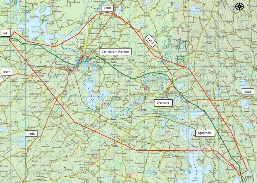
Document Verification
Job title N4 Carrick-on-Shannon to Dromod Project Job number
274219-00
Document title Project Brief File reference
Document ref 274219-ARUP-ZZ-ZM-RP-ZM-000005
Revision Date Filename 274219-ARUP-ZZ-ZM-RP-ZM-000005
P01 26 Jun Description First Draft
2020
Prepared by Checked by Approved by
Name Eileen McCarthy Hazel King Eileen McCarthy
Signature
Filename
Description
Prepared by Checked by Approved by
Name
Signature
Filename
Description
Prepared by Checked by Approved by
Name
Signature
Filename
Description
Prepared by Checked by Approved by
Name
Signature
Issue Document Verification with Document
274219-ARUP-ZZ-ZM-RP-ZM-000005 | P01 | 26 June 2020 | Arup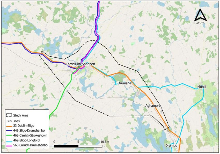
Leitrim County Council                                               N4 Carrick-on-Shannon to Dromod Project
                                                                                                 Project Brief

Contents
                                                                                                      Page

1              Introduction                                                                              1
               1.1           Overview                                                                    1
               1.2           TII Project Appraisal Deliverables                                          1
               1.2.1         Phase 0 Project Appraisal Plan (PAP)                                        2
               1.2.2         Phase 0 Project Brief                                                       2

2              Project History                                                                           3
               2.1           Overview of N4 Corridor                                                     3
               2.2           Previous Studies                                                            5
               2.2.1         N4 Carrick-on-Shannon Bypass                                                5
               2.2.2         N4 Carrick-on-Shannon to Dromod Project                                     5

3              Need for the Scheme                                                                       8
               3.1           Overview                                                                   8
               3.2           Problem Identification on Existing N4                                      8
               3.2.1         Existing Alignment                                                         8
               3.2.2         Junctions and Direct Accesses                                              9
               3.2.3         Existing Traffic Counts                                                   11
               3.2.4         Existing Travel Patterns                                                  12
               3.2.5         Existing Journey Times                                                    16
               3.2.6         Existing Public Transport Provision                                       17
               3.2.7         Existing Road Safety Issues                                               21
               3.2.8         Flooding Issues                                                           24
               3.2.9         Summary of Existing Situation                                             24

4              Strategic Fit and Priority                                                              26
               4.1           Policy Overview                                           26
               4.2           Regulation (EU) No 1315/2013                              26
               4.3           National Planning Framework                               28
               4.4           National Development Plan (NDP), 2018 – 2027              29
               4.5           Investment in our Transport Future – Strategic Investment
                             Framework for Land Transport (SIFLT)                      30
               4.6           Climate Action Plan 2019                                  31
               4.7           National Ports Policy 2013                                31
               4.8           Smarter Travel – A Sustainable Transport Future (2009 –
                             2020)                                                     32
               4.9           Road Safety Authority – Road Safety Strategy 2013 - 2020 32
               4.10          Regional Economic and Spatial Strategy for the Northern &
                             Western Regional Assembly (2020)                          33
               4.11          Local Planning Policy                                     35

274219-ARUP-ZZ-ZM-RP-ZM-000005 | P01 | 26 June 2020 | Arup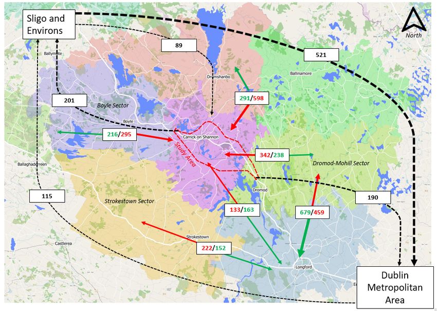
Leitrim County Council                                         N4 Carrick-on-Shannon to Dromod Project
                                                                                           Project Brief

               4.12          Policy Context Summary                                              35

5              Scope, Constraints and Interfaces                                                 37
               5.1           Geographical Scope                                                  37
               5.2           Existing Road Network Interface                                     37
               5.3           Significant Constraints                                             38

6              Objectives                                                                        39
               6.1           Project Objectives                                                  39

7              Functional and Operational Outcomes                                               42
               7.1           Design Standards                                                    42
               7.2           Performance Targets                                                 42

274219-ARUP-ZZ-ZM-RP-ZM-000005 | P01 | 26 June 2020 | Arup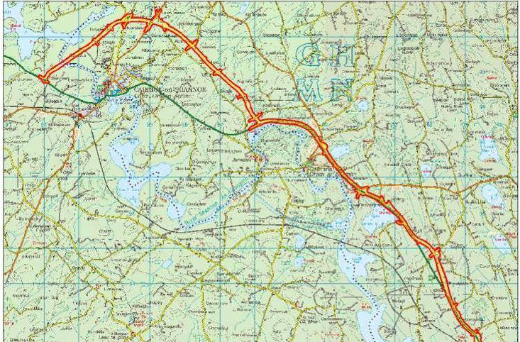
Leitrim County Council                                                     N4 Carrick-on-Shannon to Dromod Project
                                                                                                       Project Brief

1                   Introduction

1.1                 Overview
This Project Brief (PB) for the N4 Carrick-on-Shannon to Dromod Project has been
prepared by Arup in accordance with the TII Project Appraisal Guidelines (2016).
The Project Brief is a live document and will be updated as required by Arup during
the following project development stages, namely project Phase 1: Concept &
Feasibility, Phase 2: Option Selection; Phase 3: Design & Environmental
Evaluation and Phase 4: Statutory Processes.
The purpose of the Project Brief is to outline the need for investment in a solution,
explore the supporting policy documentation, and outline the particular issues that
the project is intended to address. The Project Brief then guides the subsequent
scheme development process.
The first paragraph of each of the following sections, printed in italics, gives an
overview of what each section of the Project Brief should contain as set out in PE-
PAG-02012 Unit 3.0 Project Brief.

1.2                 TII Project Appraisal Deliverables
TII PAG Unit 2.0 – Project Appraisal Deliverables specifies the project appraisal
deliverables that are required for Major National Road Projects (>€20m) during
each planning and design phase of project.
Table 1 provides a summary of the PAG deliverables relevant at each planning and
design phase of a Major Project. Phase 0 is complete and a Project Appraisal Plan
(PAP) and Project Brief were completed during this phase.
Table 1: PAG Deliverables for Major Projects by Project Phase

  PAG Deliverable                          Project Management Guidelines – Project Phases
                                           0                 1    2          3                   4
  Project Appraisal Plan                   Y
  Project Brief                            Y                 Y    Y          Y
  Traffic Modelling Report                                        Y          Y
  Cost Benefit Analysis                                           Y          Y
  Project Appraisal Balance                                       Y          Y
  Sheet (PABS)
  Preliminary Business Case                                       Y
  Detailed Business Case                                                     Y                   Y

274219-ARUP-ZZ-ZM-RP-ZM-000005 | P01 | 26 June 2020 | Arup                                               Page 1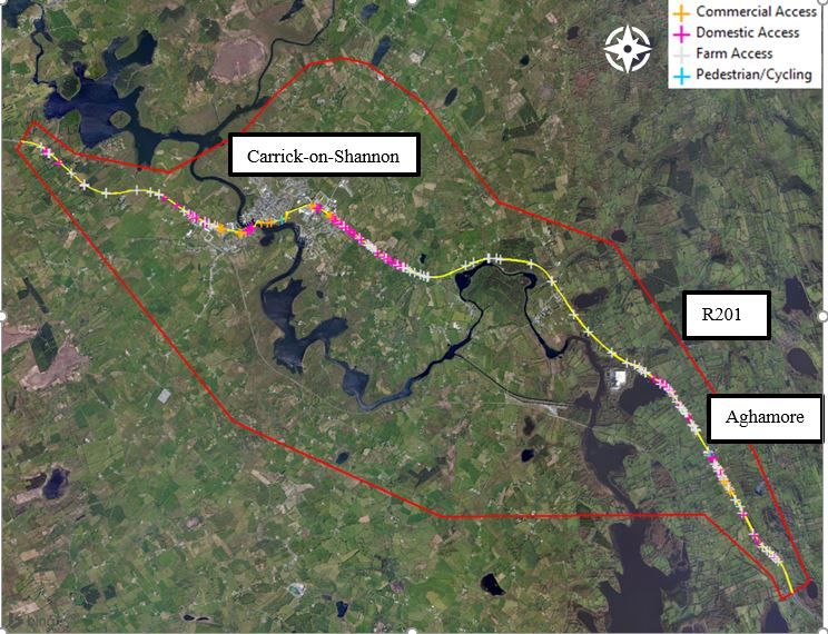
Leitrim County Council N4 Carrick-on-Shannon to Dromod Project
Project Brief
1.2.1 Phase 0 Project Appraisal Plan (PAP)
The Phase 0 Project Appraisal Plan (PAP) for the N4 Carrick-on-Shannon to
Dromod Project is a scoping document which sets out the proposed approach to the
appraisal and transport modelling of a project in advance of any significant data
collection or transport modelling being undertaken.
In line with the requirements of the Common Appraisal Framework (CAF), the
Department of Transport, Tourism and Sport (DTTaS) are to be consulted on the
appraisal assumptions and approach (CAF Section 1.5.2) and a PAP is used as the
basis for this consultation. The PAP covered the following areas:
Background of the project and the key objectives to be met
Problem Definition (i.e. Need for the Scheme)
Study Area
Methodology for consideration of alternatives & options
Sensitivity Analysis
Appraisal Scenarios
A Phase 0 PAP was completed by Roscommon National Roads Regional Office on
behalf of Leitrim County Council in July 2018. The PAP was submitted by TII to
the DTTaS Strategic Research and Analysis Division (SRAD) for review. A review
of the PAP was undertaken by SRAD who confirmed in July 2018 that the PAP was
compliant with the Public Spending Code and the Common Appraisal Framework.
1.2.2 Phase 0 Project Brief
The Phase 0 Project Brief for the N4 Carrick-on-Shannon to Dromod Project was
completed by Roscommon National Roads Regional Office on behalf of Leitrim
County Council in January 2019 and submitted to TII for approval alongside the
request to proceed to Phase 1. The approval to proceed to Phase 1 was granted by
TII in July 2019. As part of this Phase 1 Project Brief a review of the Phase 0 Project
Brief has been undertaken and where relevant up to date data (e.g. traffic levels,
collisions etc.) has been used to update the report. In addition, a review of the
relevant policy context and scheme objectives have been undertaken.
274219-ARUP-ZZ-ZM-RP-ZM-000005 | P01 | 26 June 2020 | Arup Page 2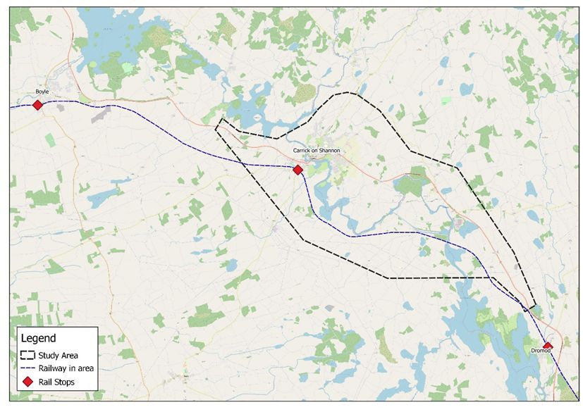
Leitrim County Council                                       N4 Carrick-on-Shannon to Dromod Project
                                                                                         Project Brief

2                   Project History
“The background to the project should be outlined including any relevant history
to the project. This should include references to relevant documents and their
conclusions and recommendations.”

2.1                 Overview of N4 Corridor
The national primary route N4, Dublin to Sligo is a strategic corridor from Dublin
to the northwest and border counties and is approximately 198km in length. It is
recognised as being of particular importance in enhancing accessibility to some of
the most peripheral areas in the northwest (including Leitrim / Roscommon / Sligo
and Donegal) and west of the River Shannon.
The N4 forms part of the EU TEN-T Comprehensive road network providing a
strategic link between Dublin and Sligo, which was designated a regional centre in
the 2018 National Development Plan and National Planning Framework. The N4
connects directly with the N5 and N6 national primary routes which also form part
of the EU TEN-T Comprehensive road network.
Significant lengths of the N4 have been improved / upgraded to dual carriageway
in the recent past. With these upgrades, especially the opening of N4 Dromod
Roosky bypass, Carrick-on-Shannon has become a bottleneck for long distance and
regional traffic. Carrick-on-Shannon remains the only regional strategic centre on
the N4 between Dublin and Sligo which has not been bypassed to date.
In 2018, the Government published the Ireland National Development Plan 2018 –
2027 (NDP). The NDP sought to progress the strategic outcomes set out in the NPF
and recognised the regional centre status of Sligo. In relation to the second National
Strategic Outcome - Enhanced Regional Accessibility the NDP states:
“… the objective is to complete those linkages so that every region and all the major
urban areas, particularly those in the North-West, which have been comparatively
neglected until recently, are linked to Dublin by a high-quality road network.”.
This project has been included in the TII National Roads Programme 2018 to 2027.
A commitment to progressing the N4 Carrick-on-Shannon to Dromod “through
pre-appraisal and early planning during 2018 to prioritise projects which are
proceeding to construction in the National Development Plan” is included in the
NDP.

274219-ARUP-ZZ-ZM-RP-ZM-000005 | P01 | 26 June 2020 | Arup                                 Page 3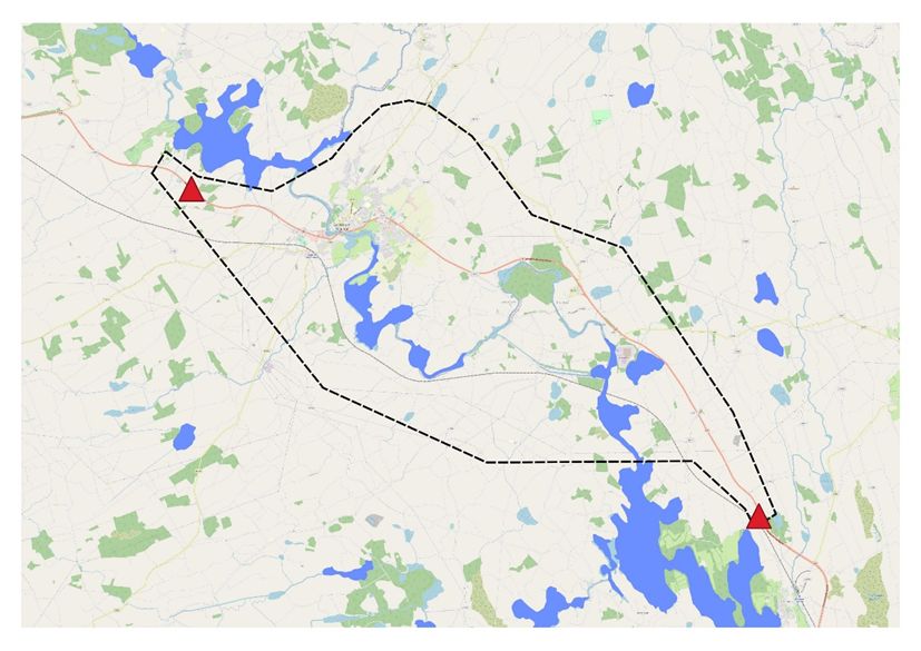
Leitrim County Council                                       N4 Carrick-on-Shannon to Dromod Project
                                                                                         Project Brief

Figure 1: Study Area for the N4 Carrick-on-Shannon to Dromod Project

Arup were appointed as consultant engineers in February 2020 to provide the
engineering and consultancy services required to deliver the N4 Carrick-on-
Shannon to Dromod Project through Phases 1 to 4 of the TII Project Management
process, including Concept and Feasibility (Phase 1), Options Selection (Phase 2),
Design and Environmental Evaluation (Phase 3) and the Statutory Processes (Phase
4). The section of the N4 under consideration falls within two local authority
administrative areas with the River Shannon acting as the boundary. The area to the
west of the River Shannon lies within County Roscommon and to the east of the
River Shannon within County Leitrim.
This section of the N4 is approximately 21km long, comprising both rural sections
(approx. 17km combined length) and urban sections (4.3km combined length). It
extends from Drumharlow townland north of Carrick-on-Shannon to Faulties
townland south of Aghamore. The rural sections were improved during the period
1994 to 2005 however there have been no improvements to the rural sections since
2005. The main towns and villages along the route are Carrick-on-Shannon,
Cortober and Aghamore. Carrick-on-Shannon and Cortober are separated by the
River Shannon and for the purposes of this report, where Carrick-on-Shannon is
referenced it is taken to mean the towns of both Carrick-on-Shannon and Cortober.
The study area as shown in Figure 1 represents the minimum anticipated study area
within which options and alternatives will be developed.

274219-ARUP-ZZ-ZM-RP-ZM-000005 | P01 | 26 June 2020 | Arup                                 Page 4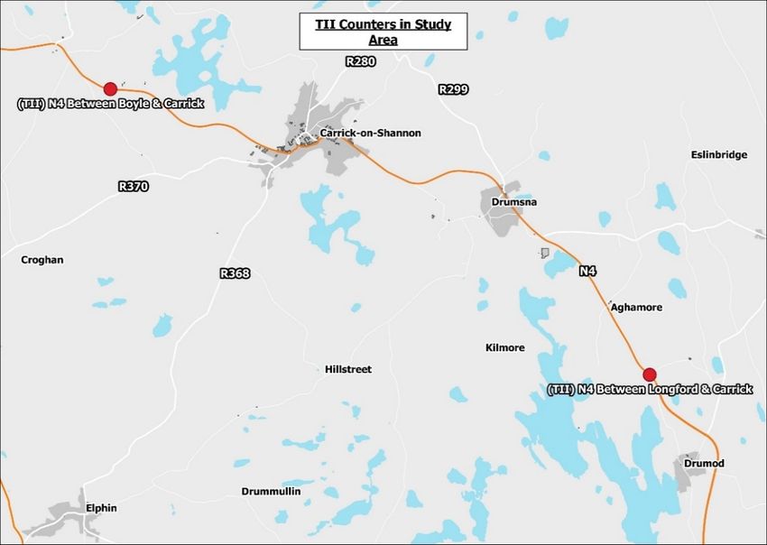
Leitrim County Council                                       N4 Carrick-on-Shannon to Dromod Project
                                                                                         Project Brief

2.2                 Previous Studies

2.2.1               N4 Carrick-on-Shannon Bypass
In 2001 Leitrim County Council appointed M.C. O’Sullivan and Company Ltd
(MCOS) to provide engineering consultancy services for an N4 Carrick-on-
Shannon Bypass Project.
The study area considered for this project extended over an area of approximately
6km in diameter centred on the town of Carrick-on-Shannon and the village of
Cortober. The studies culminated in the production of a Constraints Study report, a
Route Selection Report and the identification of a preferred route corridor, which
is a 6.3km bypass generally to the north of Carrick-on-Shannon (refer to Figure 2).
It included an at-grade junction with the R280 Regional Road.

Figure 2: N4 Carrick-on-Shannon Bypass Previous Route 2002 (in pink)

2.2.2               N4 Carrick-on-Shannon to Dromod Project
In February 2009 Leitrim County Council appointed Roughan & O’Donovan
Consulting Engineers (ROD) to provide engineering consultancy services for the
N4 Carrick-on-Shannon to Dromod Project.
The study area was considerably extended and incorporates the existing N4 road
section from Carrick-on-Shannon to the northern tie-in of the N4 Dromod Roosky
Bypass, which opened in 2007 (refer to Figure 3 ).

274219-ARUP-ZZ-ZM-RP-ZM-000005 | P01 | 26 June 2020 | Arup                                 Page 5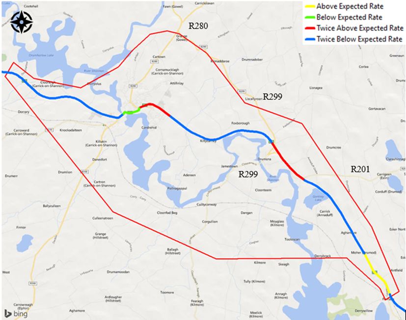
Leitrim County Council                                       N4 Carrick-on-Shannon to Dromod Project
                                                                                         Project Brief

Figure 3: Roughan & O’Donovan N4 Study Area with MCOS Previous Route 2002

This commission culminated in the production of a route corridor selection report
which identified the preferred route corridor. The preferred route corridor is
currently reserved in the Leitrim County Development Plan 2015-2021 (refer to
Figure 4).
Due to the unprecedented financial constraints the project was suspended in 2012
and in this context the preferred route corridor identified may no longer be the
optimum solution and will be reviewed as part of this scheme.

274219-ARUP-ZZ-ZM-RP-ZM-000005 | P01 | 26 June 2020 | Arup                                 Page 6
Leitrim County Council N4 Carrick-on-Shannon to Dromod Project
Project Brief
Figure 4: N4 Carrick-on-Shannon to Dromod Preferred Route 2012
274219-ARUP-ZZ-ZM-RP-ZM-000005 | P01 | 26 June 2020 | Arup Page 7Leitrim County Council N4 Carrick-on-Shannon to Dromod Project
Project Brief
3 Need for the Scheme
“The problems which the project is intended to address should be specified.
Relevant documentation, information or data that supports the existence of the
need should be briefly outlined.”
3.1 Overview
This section of the report outlines the problems on the existing section of the N4
national primary road between Faulties and Drumharlow that the project is intended
to address. These problems combined with the Strategic Fit and Priority in Section
4 of this report constitute the Need for the Scheme. The problems are discussed
under the following topics:
Existing road alignment
Existing traffic conditions
Existing journey times
Existing public transport provision
Existing road safety issues
Existing flooding issues
The text in the following sections is based on information gathered to date at this
early stage of the project with the relevant data source referenced where applicable.
Further details on the existing network will be provided during the next project
phase and the Phase 2 Project Brief will be updated to reflect the additional data
collected.
3.2 Problem Identification on Existing N4
3.2.1 Existing Alignment
The N4 carries both long distance traffic between the east and northwest of the
country, significant regional and inter-urban traffic flows between Mullingar,
Longford, Carrick-on-Shannon, Boyle and Sligo and local traffic notably through
Carrick-on-Shannon. The section of N4 through Carrick-on-Shannon provides
regional connections to other small towns via Leitrim & Manorhamilton (R280),
Elphin (R368) & Frenchpark (R370). The main regional roads connecting to this
section of the N4 are the R201, R280, R299, R368 & R370 (see Figure 1).
The road network around Carrick-on-Shannon consists primarily of a number of
radial routes emanating from Carrick-on-Shannon and Cortober. The centre of
Carrick-on-Shannon is characterised by narrow streets with limited but very
disruptive on-street parking. At present the existing N4 relief road between the
Shannon Roundabout and the River Shannon Bridge, which avoids the main street
in Carrick-on-Shannon, provides some relief to the town centre. However, the
section of the N4 immediately east of the River Shannon Bridge has extensive on-
street parking which contributes to the congestion.
274219-ARUP-ZZ-ZM-RP-ZM-000005 | P01 | 26 June 2020 | Arup Page 8Leitrim County Council N4 Carrick-on-Shannon to Dromod Project
Project Brief
Furthermore, the need for all traffic to converge to cross the River Shannon via a
single bridge combined with a narrow carriageway, frequency of sharp bends and
associated junctions continues to result in significant traffic congestion, especially
during peak periods. The existing masonry arch bridge, which was constructed in
1846, is the primary constraint to the N4 national primary route within the section
under consideration. The bridge currently caters for all ‘through’ traffic, much of
the local and regional traffic and non-motorised users (NMUs). It is noted that in
order to avoid mounting the footpath HGVs turning onto the bridge cross into the
opposite carriageway, forcing oncoming traffic to give way.
The bridge is substandard in terms of horizontal and vertical alignment with sharp
bends either side of the river. The available carriageway width on the bridge varies
between 5.45m and 5.8m for the extent of the river crossing. The cross-section for
a Type 1 Single Carriageway would be 7.3m wide plus 2.5m wide hard shoulders
and for a Type 2 Single Carriageway would be 7.0m wide plus 0.5m hard strips.
The existing cross-section is extremely sub-standard, and this results in
considerable congestion and safety issues in the town.
An analysis of the existing road geometry on the section of the N4 within the study
area has been carried out. It concludes that 13 out of 27 of the horizontal curves are
sub-standard and fall below the TII recommended standard. Therefore
approximately 17% of the length of the existing N4 within the study area has a sub-
standard horizontal alignment. A number of the sub-standard curves fall into the
Band C curves which are not recommended due to dubious overtaking conditions
they create. It also concludes that the vertical alignment of the existing N4 within
the study area is generally good, with the exception of the vertical crest curve across
the River Shannon Bridge in Carrick-on-Shannon which is two steps below
desirable minimum for a design speed of 50km/h.
3.2.2 Junctions and Direct Accesses
There are 197 direct accesses to the N4 national road within the study area. This
comprises 113 farm accesses, 58 domestic access, 24 commercial accesses and 2
pedestrian/cycle accesses. The distribution of these accesses is shown on Figure 5 .
There is a high concentration of accesses on the approaches to Carrick-on-
Shannon/Cortober and also significant clusters of accesses to the south of the
junction with the R201 and on the approaches to Aghamore village.
274219-ARUP-ZZ-ZM-RP-ZM-000005 | P01 | 26 June 2020 | Arup Page 9Leitrim County Council N4 Carrick-on-Shannon to Dromod Project
Project Brief
Figure 5: Distribution of Accesses along the existing N4
There are 52 junctions of the N4 with other roads in the study area. There are 4
junctions with regional roads, R368, R903, R280, and the R201 and there are 6
junctions associated with the slip lanes. Four of the slip lanes connect to the grade
separated junction for the R299 and 2 additional slip lanes are provided for
residential properties at Fearnaght. The remaining 42 junctions are with local roads.
The section of the route within Carrick-on-Shannon is urban in nature, with
regulatory speed limits in place over a length of approx. 3.7km. There is an
intermediate speed limit of 60km/h on the western side of Carrick-on-Shannon
which reduces to 50km/h through Carrick-on-Shannon. There are 6 at-grade
roundabout junctions on the existing N4 and two controlled pedestrian crossings, 1
at-grade local road junction (just west of the River Shannon Bridge), 9 housing
estate / commercial road junctions and a multitude of individual commercial /
domestic / agricultural accesses and close to the town centre a significant
concentration of shop frontage. There are significant conflicts between locally /
regionally generated traffic and national traffic.
The section of the route within Aghamore village is urban in nature, with regulatory
speed limits in place over a length of approx. 0.61km. There is an intermediate
speed limit of 60km/h north and south of Aghamore which reduces to 50km/h
through Aghamore. The village encompasses a national school, a church and a
restaurant / public house.
274219-ARUP-ZZ-ZM-RP-ZM-000005 | P01 | 26 June 2020 | Arup Page 10Leitrim County Council N4 Carrick-on-Shannon to Dromod Project
Project Brief
3.2.3 Existing Traffic Counts
Transport Infrastructure Ireland’s (TII) Traffic Count Data website presents
information on traffic volume and composition obtained via a network of traffic
counters embedded in the road surface. Using this database, Annual Average Daily
Traffic (AADT) volumes for the existing N4 within the study area for the year 2019
have been obtained from TII Traffic Monitoring Units (TMU) located on the route
and are presented in Table 2 below. A review of the AADT values from 2015-2019
shows that, on average, traffic levels have increased by 9.2% in the last 5 years
(1.8% per annum). The TMU locations are shown in Figure 6.
Table 2: Existing N4 AADT
Traffic Counter Location AADT (2019) HGV
(%)
N4 Between Boyle and 8,338 5.1%
Carrick-on-Shannon, Usna,
Co. Roscommon
N4 Between Longford and 7,468 6.3%
Carrick-on-Shannon,
Dromod Bypass, Co. Leitrim
Figure 6: Traffic Counter Locations
Average weekday traffic flow profiles extracted from the TMU’s listed above
shows that the AM peak occurs between 08:00 - 09:00 and the PM peak occurs
between 17:00 - 18:00. Relatively high levels of traffic prevail in the interpeak
period (14:00 - 16:00), indicating that this section of the N4 is well used throughout
the day and that the majority of demand is not solely related to commuting traffic.
274219-ARUP-ZZ-ZM-RP-ZM-000005 | P01 | 26 June 2020 | Arup Page 11Leitrim County Council N4 Carrick-on-Shannon to Dromod Project
Project Brief
In addition to the TII TMU data outlined above a number of Junction Turning Count
(JTC) surveys were undertaken along the N4 in Carrick-on-Shannon on Friday, 1
March 2019. This data has been used in combination with permanent traffic
counters to estimate AADT values at the relevant locations for 2019. These AADT
values are illustrated on the map below and show that the level of traffic on the N4
in Carrick-on-Shannon is well above that experienced on the approaches to the town
(as recorded by the TII TMUs). The highest AADT recorded is 18,100 outside the
Landmark Hotel. The AADT value on Shannon Bridge in Carrick-on-Shannon was
17,500. This is well in excess of the design capacity for a Type 2 single carriageway
(8,600 at a level of service D)1. It is also well in excess of the design capacity for a
Type 1 single carriageway (11,600 at a level of service D)2 and the bridge cross-
section is far less than that required for a Type 1 Single Carriageway as noted in
Section 3.2.1 above.
Figure 7: AADT in Carrick-on-Shannon’s ATCs
The narrow carriageway, the crest vertical curve on the bridge, the frequency of
sharp bends and associated junctions at either side of the bridge, all compound the
situation for all modes trying to use the bridge, and this includes non-motorised
users as well as HGVs. All share the same congested space and the volume at
17,500 AADT totally exacerbates the situation. The resulting congestion at peak
hours, peak tourist season, match days and special events has a significant negative
impact on accessibility to the town, commercial through traffic and businesses on
both the periphery and within the town centre.
3.2.4 Existing Travel Patterns
Using information from the 2016 Census, the CSO has developed a set of aggregate
commuting counts. These counts are presented at electoral division (ED) and
county level and provide the total number of trips which take place between each
ED. The counts are based on origin and destination EDs for workers and students
who are usually resident in Ireland. The counts include persons who work from
1 Based on TII publication “Rural Road Link Design (DN-GEO-03031 2017)
2 Based on TII publication “Rural Road Link Design (DN-GEO-03031 2017)
274219-ARUP-ZZ-ZM-RP-ZM-000005 | P01 | 26 June 2020 | Arup Page 12Leitrim County Council N4 Carrick-on-Shannon to Dromod Project
Project Brief
home and persons who had no fixed place of work. It is emphasised again that these
figures only represent person trips (total of all modes) to work and education and
exclude other trip purposes.
This 2016 commuting data has been processed and analysed to establish the
quantity and direction of strategic commuting trips likely to use the N4 between
Sligo and Longford, during the AM period. For ease of representation, ED’s have
been aggregated into larger sectors and any smaller movements between sectors
(Leitrim County Council N4 Carrick-on-Shannon to Dromod Project
Project Brief
Figure 8: Commuting Data for Workers and Students (CSO 2016)
274219-ARUP-ZZ-ZM-RP-ZM-000005 | P01 | 26 June 2020 | Arup Page 14
\\ARUPPW14ICS01\ICS_PDF_WORK_DIR\26\1642_14\274219-ARUP-01-CF-RP-Z-000003.DOCXLeitrim County Council N4 Carrick-on-Shannon to Dromod Project
Project Brief
Table 3: Commuting Data
From \ To Boyle Carrick- Dromod- Longford Drumshambo Ballinamore Strokestown Sligo and Dublin Study Area
Sector on- Mohill Sector Sector Sector Sector Environs Metropolitan
Shannon Sector Area
Sector
Boyle Sector / 295 10 36 34 5 50 564 107 /
Carrick-on- 216 / 238 163 281 39 84 235 207 /
Shannon
Sector
Dromod-Mohill 21 342 / 679 46 204 30 93 245 /
Sector
Longford 15 133 459 / 7 19 152 68 558 /
Sector
Drumshambo 170 598 61 48 / 48 9 536 125 /
Sector
Ballinamore 8 174 234 64 124 / 3 83 183 /
Sector
Strokestown 181 182 10 222 23 2 / 105 147 /
Sector
Sligo and 80 89 8 29 50 3 5 / 521 89
Environs
Dublin 0 16 4 92 6 6 1 115 / 15
Metropolitan
Area
Study Area / / / / / / / 201 190 /
The table represents the start point and end point for the trips, e.g. 295 trips go from the Boyle sector to the Carrick-on-Shannon sector and remain in that sector.
274219-ARUP-ZZ-ZM-RP-ZM-000005 | P01 | 26 June 2020 | Arup Page 15
\\ARUPPW14ICS01\ICS_PDF_WORK_DIR\26\1642_14\274219-ARUP-01-CF-RP-Z-000003.DOCXLeitrim County Council N4 Carrick-on-Shannon to Dromod Project
Project Brief
The above results show that one of the largest commuting movements along this
corridor in the AM peak is between Sligo and Environs and the Dublin Metropolitan
Area (521 trips). Other notable commuting movements involving the Carrick-on-
Shannon Sector, which broadly matches the project study area, include:
598 trips from the Drumshambo Sector to Carrick-on-Shannon
281 trips from Carrick-on-Shannon to Drumshambo
235 trips from Carrick-on-Shannon sector to Sligo
207 trips from the Carrick-on-Shannon sector to the Dublin Metropolitan area
Further work will be undertaken in Phase 2 to break down these sectors into smaller
areas to understand the final destination within the sector and whether that
destination also involves a crossing of the River Shannon.
3.2.5 Existing Journey Times
Empirical journey time measurements during April 2018 recorded average journey
speeds within the study area were measured at 65km/h for weekday peak and inter
peak period but dropped to 57km/h during the Friday PM peak. These journey
speeds are significantly less than the National Planning Framework target of
90km/h for inter-urban roads (per National Strategic Outcome 2).
Empirical journey time measurements through Carrick-on-Shannon (between the
60km/h speed limits) recorded average journey speeds of 23km/h during Friday PM
Peak.
Complete breakdown in network traffic flow is a regular occurrence during the
tourist season, bank holidays, matchdays, special events and at certain periods over
normal weekends often requiring intervention by An Garda Síochána to maintain a
through flow in Carrick-on-Shannon. It is noted that over the 2018 May Bank
Holiday weekend a breakdown in network traffic flow in Carrick-on-Shannon led
to a 2.5km tailback developing on the N4 eastbound approach to the town.
Supplementary journey time data for this section of the N4 was collected via Google
Maps Distance Based Application Programme Interface (API). End to end journey
times for the section of the N4 under consideration were collected in both directions
for the AM peak (08:00 – 09:00), Inter-peak (11:00 – 12:00), and PM peak (17:00
– 18:00) periods. For the purposes of this exercise a neutral, mid-week, day in
November 2019 was selected for the journey time extraction.
Table 4 below shows the average end to end journey time and resulting average
speeds as extracted from the Google API. The start and end points for this journey
time assessment are shown in Figure 9. In general, these tables show little variation
in journey time between the two peak periods with average speeds between 61km/h
and 72km/h achieved. Journey times during the inter-peak period are not
significantly faster than peak period journey times.
274219-ARUP-ZZ-ZM-RP-ZM-000005 | P01 | 26 June 2020 | Arup Page 16
\\ARUPPW14ICS01\ICS_PDF_WORK_DIR\26\1642_14\274219-ARUP-01-CF-RP-Z-000003.DOCXLeitrim County Council N4 Carrick-on-Shannon to Dromod Project
Project Brief
Table 4: Google Maps – Journey Time Data
AM peak Interpeak PM peak
Direction Speed Time Speed Time Speed Time
(km/h) (min) (km/h) (min) (km/h) (min)
Eastbound 71.5 17.1 71.6 17.0 67.6 18.1
Westbound 66.1 18.4 71.7 17.0 61.5 19.8
Figure 9: End to End Journey Locations
3.2.6 Existing Public Transport Provision
3.2.6.1 Rail Network
The study area interacts with the western rail line extending from Dublin Connolly
(City Centre) to Sligo. This service serves a number of towns located along, or close
to the N4 corridor, including Mullingar, Longford, Dromod, Carrick-on-Shannon,
Boyle and Collooney. Figure 10 below illustrates the N4 corridor and Dublin-Sligo
Rail line. This line is single track between Sligo and Maynooth.
274219-ARUP-ZZ-ZM-RP-ZM-000005 | P01 | 26 June 2020 | Arup Page 17
\\ARUPPW14ICS01\ICS_PDF_WORK_DIR\26\1642_14\274219-ARUP-01-CF-RP-Z-000003.DOCXLeitrim County Council N4 Carrick-on-Shannon to Dromod Project
Project Brief
Figure 10: Rail Network
The journey time between Dublin and Sligo is approximately 3 hours and there is a
total of 8 daily weekday services in each direction between Dublin and Sligo, with
a reduced number of services at weekends.
The 2018 National Transport Authority Heavy Rail Census provides data on the
number of daily rail passengers boarding and alighting at each station. Table 5
below provides these daily passenger figures for each station between Longford and
Sligo.
Table 5: Railway Passenger Data
Station Boarding Alighting
Northbound Southbound Northbound Southbound
Longford 58 279 342 68
Dromod 18 68 68 29
Carrick-on- 48 95 109 34
Shannon
Boyle 27 91 19 19
Ballymote 58 60 57 40
Collooney 14 50 72 4
Sligo N/A 460 436 N/A
The above figures show a relatively low demand at stations along the Sligo-Dublin
corridor within, and close to, the study area. This is likely reflective of the limited
number of services and dispersed population within the study area.
274219-ARUP-ZZ-ZM-RP-ZM-000005 | P01 | 26 June 2020 | Arup Page 18
\\ARUPPW14ICS01\ICS_PDF_WORK_DIR\26\1642_14\274219-ARUP-01-CF-RP-Z-000003.DOCXLeitrim County Council N4 Carrick-on-Shannon to Dromod Project
Project Brief
3.2.6.2 Bus Network
There are a limited number of bus services within the study area. These are as
follows:
Bus Eireann Expressway (Route 23) Dublin to Sligo operates 6 daily services
in each direction
West Link Coaches (Route 449) Sligo to Drumshanbo operates 1 daily service
in each direction
Bus Eireann Coaches (Route 468) Carrick-on-Shannon to Strokestown
operates 2 daily services in each direction, on Mondays, Wednesdays and
Saturdays
Bus Éireann Coaches (Route 469) Sligo to Longford operates 1 daily service
in each direction
Local Link Coaches (Route 568) Carrick-on-Shannon to Drumshambo
operates 3 daily services in each direction
These bus services are illustrated in Figure 11 below.
274219-ARUP-ZZ-ZM-RP-ZM-000005 | P01 | 26 June 2020 | Arup Page 19
\\ARUPPW14ICS01\ICS_PDF_WORK_DIR\26\1642_14\274219-ARUP-01-CF-RP-Z-000003.DOCXLeitrim County Council N4 Carrick-on-Shannon to Dromod Project
Project Brief
Figure 11: Bus Service Routes
274219-ARUP-ZZ-ZM-RP-ZM-000005 | P01 | 26 June 2020 | Arup Page 20
\\ARUPPW14ICS01\ICS_PDF_WORK_DIR\26\1642_14\274219-ARUP-01-CF-RP-Z-000003.DOCXLeitrim County Council N4 Carrick-on-Shannon to Dromod Project
Project Brief
The above shows that there are a very limited number of bus services available in
the study area with only 1 route serving the entire section of the N4 under
consideration (BÉ route 23).
Bus services utilising the N4 must negotiate the same traffic volumes as private cars
and are subject to the same unreliability in journey time – this in turn disincentivises
take up of public transport alternatives to the private car.
3.2.7 Existing Road Safety Issues
An analysis of the collision history of this section of road for the period 2005 to
2014 has identified three significant accident locations as follows:
1. Carrick-on-Shannon – The road network through Carrick-on-Shannon shows a
large cluster of minor and serious collisions as this is where the potential for
conflict between road traffic, pedestrians and cyclists is highest
2. Mountcampbell (TII Site ID N04LM_139.0) – Two collisions with three
fatalities and 1 minor injury (i.e. on the N4 Jamestown to Drumsna Bypass
which was opened in 1996 just north of the N4/R299 Junction)
3. N4 Junction at the R201 (TII Site ID N04_137.0) – Three minor collisions
In addition, the existing route contains the following problematic road safety
concerns:
Change in carriageway cross-section from Type 2 Dual Carriageway to Two-
Way Single Carriageway without the provision of a junction to demark the
change in cross-section. This does not comply with the recommendations of
Section 8.7 of TII Publication DN-GEO-03031 (Rural Link Design)
Direct access from Annaduff GAA club grounds and the adjacent Leitrim GAA
Centre of Excellence to the N4 on the 100km/h speed limit
50km/h speed limit and associated traffic calming measures at Aghamore
6 roundabouts over 2.2km within the Carrick-on-Shannon 50km/h speed limit,
which is an area with significant vulnerable road users
Direct access from the Leitrim GAA County Grounds (Páirc Seán Mac
Diarmada) within the 50km/h speed limit
On street parking on the N4 at commercial premises within the 50km/h speed
limit
Zebra controlled crossings on the national primary route
Substandard carriageway width and restricted facilities for vulnerable road
users at the River Shannon bridge crossing in Carrick-on-Shannon
No facilities for vulnerable road users outside of the urban area of Carrick-on-
Shannon
TII Publication GE-STY-01022 (formerly NRA HD 15) is used to identify sections
of the national road network which have a high concentration of collisions and to
rank the safety of the road network. The ranking is based on the collision rate
274219-ARUP-ZZ-ZM-RP-ZM-000005 | P01 | 26 June 2020 | Arup Page 21Leitrim County Council N4 Carrick-on-Shannon to Dromod Project
Project Brief
(number of collisions per 100 million vehicle kilometres travelled) on road sections
of approximately 1km compared against the national average collision rate for a
similar road type.
Figure 12 and Figure 13 show the rankings for the section of the N4 under
consideration from 2014 to 2016 and 2015 to September 2017 respectively. This
demonstrates that both urban (Carrick-on-Shannon) and rural sections (R201 to
R299 junction) of the N4 consistently have collision rates that are twice above the
national average for the relevant carriageway classification.
The narrow carriageway, the crest vertical curve on the bridge, the frequency of
sharp bends and associated junctions at either side of the bridge, all compound the
situation for all modes trying to use the bridge, and this includes non-motorised
users as well as HGVs. All share the same congested space and the volume at
17,500 AADT totally exacerbates the situation. The resulting congestion at peak
hours, peak tourist season, match days and special events has a significant negative
impact on accessibility to the town, commercial through traffic and businesses on
both the periphery and within the town centre.
Finally, the existing N4 national primary route through Carrick-on-Shannon is a
barrier to pedestrian movement and mixes high vehicular volumes with non-
motorised road users. All modes are sharing the same very limited space, including
non-motorised users and HGVs, and the number of trips in this limited space far
exceeds the space capacity for safe use, which leads to safety concerns. The
constant traffic/pedestrian interaction/interference is a safety concern for residents
in the town, and is a disincentive to cycling or walking, which in turn leads to further
increased private car usage. This is a cyclical trend which can only be addressed
by firstly reducing the traffic volumes to a safe level through proper land use and
transport planning.
274219-ARUP-ZZ-ZM-RP-ZM-000005 | P01 | 26 June 2020 | Arup Page 22Leitrim County Council N4 Carrick-on-Shannon to Dromod Project
Project Brief
Figure 12: Collision Rates 2014 to 2016 (Source: Transport Infrastructure Ireland)
Figure 13: Collision Rates 2015 - September 2017 (Source: Transport Infrastructure Ireland)
274219-ARUP-ZZ-ZM-RP-ZM-000005 | P01 | 26 June 2020 | Arup Page 23Leitrim County Council N4 Carrick-on-Shannon to Dromod Project
Project Brief
3.2.8 Flooding Issues
There is a flood risk on the existing N4 given that the River Shannon meanders
through the study area in a north-south direction with the N4 in close proximity to
the river and its floodplain at various points. The flood plain associated with the
river is extensive and covers a considerable area. The river also features a number
of large lakes within the study area including Lough Tap, Lough Corry and Lough
Nanogh. Other individual lakes within the study area include Gortinty Lough,
Cartron Lough, Lowfield Lough, Spa Lough, Ballagh Lough and Gortconnellan
Lough. In addition to the River Shannon, the N4 crosses 17 additional watercourses
ranging from small rivers and streams to seasonal field drains in the study area.
In the period 1999 to 2017, traffic flow and the serviceability of the N4 along the
section under consideration was seriously affected for extended durations. Flooding
has led to the closure and associated diversion of the route on three separate
occasions, with the N4 being closed for a period of 19 days in November 2009.
In December 2017, the closure of the N4 immediately north of the bridge required
traffic travelling north to divert via Roosky along the R371 regional road, N5
national primary road and the N61 national secondary road before re-joining the N4
at Boyle adding approx. 20km to the journey. Southbound traffic diverted at
Ardcarne along regional roads R285, R284, R280 and R299 before joining the N4
at Drumsna adding approx. 12km to the journey. While the northbound diversion
route can accommodate national road traffic in the short term the southbound
diversion route is wholly inadequate for anything other than emergencies.
3.2.9 Summary of Existing Situation
The problems on the existing N4 under consideration described above can be
summarised as follows:
River Shannon Bridge – protected structure constructed in 1846 carrying an
AADT of approximately 15,000. Cross-section does not provide carriageway
or raised verge width in accordance with current TII Standards. A new
cantilever footbridge was constructed on the north side of the existing structure
in 2010 facilitating pedestrian movement across the River Shannon. Pedestrians
on the southern side of the N4 continue to use the existing narrow footpath.
Cyclists utilise the existing carriageway on both the northern and southern side
of the N4.
A serious collision on the River Shannon Bridge crossing or it’s approaches
would lead to an unsustainable diversion route
Road geometry is not in accordance with current standards
There are six roundabouts within a 2km long section urban section in Carrick-
on-Shannon, none of which cater for vulnerable road users
Existing space allocation in Carrick-on-Shannon for trips / movement is wholly
inadequate for the quantum of trips to be undertaken safely, and this impacts on
vulnerable road users to the greatest degree
274219-ARUP-ZZ-ZM-RP-ZM-000005 | P01 | 26 June 2020 | Arup Page 24Leitrim County Council N4 Carrick-on-Shannon to Dromod Project
Project Brief
Existing journey times – average 90km/h inter-urban speed is not achievable on
the national route. Severe congestion is experienced at peak times, particularly
during the peak tourist season, bank holiday weekends and special events
Road Safety – sections of the N4 under consideration consistently experience
collision rates twice above the national average rate; particularly within the
urban area of Carrick-on-Shannon and the rural area between the R201 and
R299 junctions where collision clusters are evident
Road Safety – high number of junctions and direct accesses
Environment - the existing environment in Carrick-on-Shannon is unsafe and
unpleasant due to the high level of road traffic passing through the town
contributing to severance (particularly for vulnerable road users), high noise
levels, and reduced air quality in the town
Flooding – N4 national primary route experienced severe traffic disruption and
lane/road closures at three locations in 2009, when a 1 in 200-year flood level
was experienced. In 2015, the N4 national primary route was closed at one
location when the 1 in 100-year flood level occurred
Accessibility - the N4 in Carrick-on-Shannon is separating the public from the
existing riverside amenities and restricting further tourism riverside
development. The level of traffic on the N4 is a barrier to movement within the
town and would restrict the mode share of walking and cycling for short trips
274219-ARUP-ZZ-ZM-RP-ZM-000005 | P01 | 26 June 2020 | Arup Page 25Leitrim County Council N4 Carrick-on-Shannon to Dromod Project
Project Brief
4 Strategic Fit and Priority
“The compatibility of the proposed project with existing policies and plans should
be set out. Any priority accorded the project in relevant plans and programmes
should be noted. The inclusion of the project in any of the following plans and
policies should be referenced:
4.1 Policy Overview
The following European, National, Regional and Local policy documents either
reference the N4 or directly reference the N4 Carrick-on-Shannon to Dromod
Project.
Trans-European Transport Network (TEN-T) Regulation (EU) No 1315/2013
of the European Parliament and the Council of 11 December 2013
Project Ireland 2040 - National Planning Framework; Department of Housing,
Planning and Local Government
Project Ireland 2040 - National Development Plan 2018 – 2027 (NDP);
Department of Public Expenditure and Reform
Strategic Investment Framework for Land Transport (SIFLT); Department of
Transport, Tourism and Sport (DTTaS)
Climate Action Plan 2019
National Ports Policy 2013
Smarter Travel – A Sustainable Transport Future (2009 - 2020)
Road Safety Strategy 2013 – 2020, Road Safety Authority
Regional Spatial and Economic Strategy for the Northern & Western Regional
Assembly (2020)
Leitrim County Development Plan (2015 - 2021) (CDP), Leitrim County
Council
Carrick-on-Shannon Local Area Plan (2010) (LAP), Leitrim County Council
Roscommon County Development Plan (2014 - 2020) (CPD), Roscommon
County Council
Cortober Area Plan contained within the Roscommon County Development
Plan (2014 - 2020)
4.2 Regulation (EU) No 1315/2013
The TEN-T networks are a set of road, rail, air and water transport networks in
Europe. The N4 corridor forms part of the TEN-T comprehensive network
connecting Dublin to the west and northwest of the country as shown in Figure 14.
274219-ARUP-ZZ-ZM-RP-ZM-000005 | P01 | 26 June 2020 | Arup Page 26Leitrim County Council N4 Carrick-on-Shannon to Dromod Project
Project Brief
Figure 14: TEN-T network connecting Dublin to the West and Northwest
Regulation (EU) Number 1315/2013 sets out the requirements for high quality
roads that shall form part of the TEN-T road network, both Core (2030)3 and
Comprehensive (2050)4, and states under Article 17(3), the following:
“High-quality roads shall be specially designed and built for motor traffic, and
shall be motorways, express roads or conventional strategic roads”.
Article 10 of the EU Directive No. 1315/2013 sets out the general priorities in the
development of the comprehensive network and states:
“In the development of the comprehensive network, general priority shall be given
to measures that are necessary for:
a) Ensuring optimal integration of the transport modes and interoperability
within transport modes;
b) Bridging missing links and removing bottlenecks, particularly in cross-border
sections;
c) Promoting the efficient and sustainable use of the infrastructure and, where
necessary, increasing capacity”
3 The TEN-T Core network is targeted for completion by 2030
4 The TEN-T Comprehensive network is targeted for completion by 2050
274219-ARUP-ZZ-ZM-RP-ZM-000005 | P01 | 26 June 2020 | Arup Page 27Leitrim County Council N4 Carrick-on-Shannon to Dromod Project
Project Brief
Improvements to the TEN-T comprehensive network would enhance growth to the
northwest, thus helping achieve the goal of increased regional connectivity to the
northwest.
4.3 National Planning Framework
The National Planning Framework (NPF) – Project Ireland 2040 (NPF) was
published by the Government on 16 February 2018. It sets out a new strategic
planning and development context for Ireland and all its regions up to 2040, setting
a high-level framework for the co-ordination of a range of national, regional and
local authority policies and activities, planning and investment, both public and
private. The objective of the NPF is to create a single vision with a shared set of
goals for every community across the country. These goals are expressed in the
NPF in ten National Strategic Outcomes (NSO) as shown in Figure 15. The NPF
sets out the National Policy Objectives (NPO) which are designed to deliver the
NSOs.
Figure 15: National Strategic Outcomes per National Planning Framework
274219-ARUP-ZZ-ZM-RP-ZM-000005 | P01 | 26 June 2020 | Arup Page 28Leitrim County Council N4 Carrick-on-Shannon to Dromod Project
Project Brief
On review of these NSOs, a resolution to the transportation issues on the N4
corridor from Carrick-on-Shannon to Dromod is required in order to deliver on all
of these NSOs. It is necessary to remove traffic from the urban centre of Carrick-
on-Shannon/Cortober so that this area can be an attractive area to live and work,
thus delivering on compact growth. Once compact growth is achievable, NSO 4 is
achievable as the trip lengths and journeys are much shorter and are possible by
sustainable modes, which in turn delivers on NSO 8 in transitioning to a low carbon
economy and NSO 7 in enhancing access to the very significant amenity of the
River Shannon. In addition, enhanced accessibility to the northwest of Ireland,
linking of the rural communities, strengthening economies and international
connectivity are realisable when the congestion on the N4 is resolved.
NPO 2c states “Accessibility to the north-west of Ireland and between centres of
scale separate from Dublin will be improved, focused on cities and larger
regionally distributed centres and on key east-west and north-south routes”.
Under NSO 2 “Enhancing Regional Accessibility”, there is a specific objective to
improve accessibility to the northwest by “upgrading northern sections of the N4
and N5 routes and sections of the N3/M3 primary route”
In addition, under this NSO there are specific objectives in relation to inter-urban
roads:
Maintaining the strategic capacity and safety of national roads network
including planning for future capacity enhancements
Improving average journey times targeting an average interurban speed of
90kph
In this regard the proposed project is consistent with the National Planning
Framework.
The Plan also identifies the impact Brexit may have on this area and states:
“Better accessibility between the four cities and to the Northern and Western region
will enable unrealised potential to be activated as well as better preparing for
potential impacts from Brexit”
4.4 National Development Plan (NDP), 2018 – 2027
In February 2018, the Government published the National Development Plan 2018
– 2027 which sets out the investment priorities that will underpin the successful
implementation of the new National Planning Framework (NPF). The NDP seeks
to progress the strategic outcomes set out in the NPF and recognises one of the core
priorities under the NPF is to upgrade accessibility between urban centres of
population and the regions in order to maximise the growth potential of the
economy. To date there has been significant investment in linking the regions, with
the NDP now focusing on completing these linkages as follows:
“… the objective is to complete those linkages so that every region and all the major
urban areas, particularly those in the North-West, which have been comparatively
neglected until recently, are linked to Dublin by a high-quality road network.”.
274219-ARUP-ZZ-ZM-RP-ZM-000005 | P01 | 26 June 2020 | Arup Page 29Leitrim County Council N4 Carrick-on-Shannon to Dromod Project
Project Brief
A commitment to progressing the N4 Carrick-on-Shannon to Dromod project
“through pre-appraisal and early planning during 2018 to prioritise projects which
are proceeding to construction in the National Development Plan” is included in
the NDP.
The NDP explicitly recognises Sligo as fulfilling the role of a regional centre. It
states that Investment in national, regional and local road infrastructure will be
delivered in accordance with the NPF. It will be guided by the findings of the
Department of Tourism, Transport and Sport’s SIFLT analysis.
Roads will be maintained to a high quality
Roads will be improved to reduce journey times, remove bottlenecks and
improve safety
New roads will be built to connect communities and encourage economic
activity
The provision of a high-quality transport solution connecting Sligo and the Tier 1
Port of Dublin and Dublin Airport will assist in attracting investment and job
growth to the regional centre, thus enabling delivery on a strong economy in the
northwest which is in line with NSO 5 of the NDP.
Again, as with the NPF, the proposed project is consistent with the NDP, which
essentially sets out the funding mechanism for the NPF.
4.5 Investment in our Transport Future – Strategic
Investment Framework for Land Transport
(SIFLT)
The Strategic Investment Framework for Land Transport (SIFLT), published by the
Department of Transport, Tourism and Sport (DTTaS), recognises that an effective
transport network is central to the functioning of society and the economy.
This framework provides a number of principles and priorities as criteria against
which land based transport programmes will be drawn up and assessed. Rather than
setting out a list of projects to be prioritised, SIFLT forms a filter for transport
investment projects prior to their appraisal for suitability for inclusion in
national/regional programmes. These priorities include:
Priority 1: Achieve Steady State Maintenance
Priority 2: Address Urban Congestion
Priority 3: Maximise the Value of Existing Land Transport Networks
Investment in the section of the N4 corridor under consideration is supported by a
number of the priorities set out within SIFLT, in that an N4 upgrade would likely
address some urban congestion. Furthermore, the third priority of the SIFLT is
particularly relevant in the context of proposals to upgrade the specified section of
the N4. The underlying principles of this priority are that any further investment
should be targeted to maximise the contribution of the land transport networks by
enhancing the efficiency of the existing network, particularly:
274219-ARUP-ZZ-ZM-RP-ZM-000005 | P01 | 26 June 2020 | Arup Page 30Leitrim County Council N4 Carrick-on-Shannon to Dromod Project
Project Brief
In the case of roads, investment should provide access to poorly served
regions, access for large-scale employment proposals, complete missing links
or address critical safety issues
Support identified national and regional spatial planning priorities
4.6 Climate Action Plan 2019
The Climate Action Plan 2019 to Tackle Climate Breakdown was published by the
Government of Ireland in 2019. The objective of this Plan is to reduce Ireland’s
greenhouse gas emissions by 2030 across a number of key areas including
Electricity, Buildings, Transport, Agriculture, Enterprise and Services and Waste
and the Circular Economy.
The Climate Action Plan 2019 recognises the challenge for the transport sector
associated with the projected population and jobs growth in Project Ireland 2040 as
is clear in the following extract from Section 10.1.
By 2040, the population of Ireland is expected to grow by over 1 million to 5.7
million people. This growth, along with other National Planning Framework (NPF)
growth projections on the economy and employment rates, will drive greater
demand for transport across various modes, with increased movement of people
and goods. While this is a sign of a vibrant economy, it intensifies our
decarbonisation challenge, in particular as transport accounted for 19.8% of
Ireland’s greenhouse gases in 2017.
…While Project Ireland 2040 will drive more compact, connected development,
and new public transport networks, they will not on their own reverse the growth
of emissions which are projected to grow by 25%.
The Climate Action Plan 2019 proposes the introduction of new legislation to
(i) ban the sale of new fossil fuel cars from 2030 and
(ii) stop the granting of NCT certificates from 2045 to fossil fuel cars5.
The Climate Action Plan, 2019 target is that by 2030, 840,000 EV will be in use on
Irish roads.
In terms of the N4, a better-connected transportation network for all users and
improvement in safety will encourage a modal shift towards more sustainable
travel. Furthermore, through reduction in vehicle numbers within settlement areas
the proposed project will support the plan by reducing transportation impacts on air
quality on people in towns and villages.
4.7 National Ports Policy 2013
The National Ports Policy was published by DTTAS in 2013. The report introduces
clear categorisation of the ports sector based on significance and the port
governance model to be adopted by Ireland.
5 A Draft General Scheme of the Climate Action (Amendment) Bill 2019 in January 2020
274219-ARUP-ZZ-ZM-RP-ZM-000005 | P01 | 26 June 2020 | Arup Page 31Leitrim County Council N4 Carrick-on-Shannon to Dromod Project
Project Brief
Dublin Port is a Tier 1 port of National Significance. Tier 1 ports are categorised as
ports that:
are responsible for 15% to 20% of overall tonnage through Irish ports
have clear potential to lead the development of future port capacity in the
medium and long term, when and as required
In order to provide resilience to the Irish trading networks following potential
outcomes of the Brexit process it is important the internal linkages to Tier 1 ports
are enhanced. The N4 is the primary link from Sligo, which is a Project Ireland
2040 assigned urban growth as well as linking the northwest of the country to this
Tier 1 port.
In addition, Sligo is identified as a ‘Port of Regional Significance’. These are ports
that serve an important regional purpose and/or specialised trades or maritime
tourism. In this regard, the National Ports Policy recognises the importance of these
ports in serving their hinterlands and in supporting balanced regional development.
4.8 Smarter Travel – A Sustainable Transport
Future (2009 – 2020)
Smarter Travel, A Sustainable Transport Future 2009-2020, presents a transport
policy framework for Ireland covering the period up to 2020. The policy, launched
by the Department of Transport in 2009, sets out a vision, goals and targets to be
achieved, and outlines 49 actions that form the basis for achieving a more
sustainable transport future. One of the key goals of the initiative is:
“Improve economic competitiveness through maximising the efficiency of the
transport system and alleviating congestion and infrastructural bottlenecks”
This key goal as defined within the policy document, in relation to maximising the
efficiency of the transport system and alleviating congestion and infrastructure
bottlenecks aligns entirely with the ambitions of the Carrick-on-Shannon to
Dromod Project.
Chapter 3 acknowledges that “transport is vital for our economy. As an island
nation we need good transport connections with our trading partners; we also need
to ensure efficient movement on the island. Safe and comfortable travel is also a
key element of a good quality of life. The issue is not to restrict travel and transport
but to facilitate smarter ways of meeting these needs”.
The Smarter Travel actions seek to balance the multiple functions of the road
network whilst still achieving the overall key goals.
4.9 Road Safety Authority – Road Safety Strategy
2013 - 2020
The Road Safety Authority (RSA) Road Safety Strategy 2013 – 2020, sets outs
targets to be achieved in terms of road safety in Ireland as well as policy to achieve
these targets. The primary target of this strategy is:
274219-ARUP-ZZ-ZM-RP-ZM-000005 | P01 | 26 June 2020 | Arup Page 32You can also read