City of Hesperia Ranchero Road Corridor Phase III Ranchero Road Widening Project Hesperia, California
←
→
Page content transcription
If your browser does not render page correctly, please read the page content below
City of Hesperia

      Ranchero Road Corridor Phase III
      Ranchero Road Widening Project
           Hesperia, California
A Roadmap for Economic Progress and Responsible Growth

    Transportation Investment Generating Economic Recovery (TIGER)
                        2017 Grant Application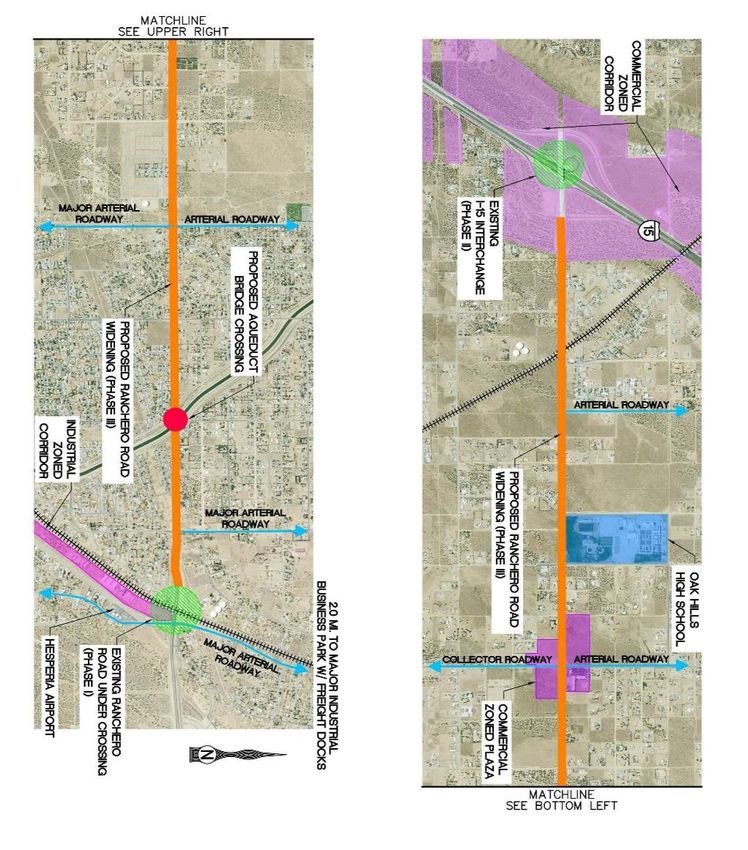
City of Hesperia
RANCHERO ROAD WIDENING PROJECT

FY 2017 TIGER Grant Application
Organization Name/Lead Applicant: City of Hesperia
DUNS Number: 1969746380000

Authorized Representative: Nils Bentsen, City Manager

Total Project Cost: $37,000,000
TIGER Request: $9,700,000
Total Non-federal Funding (match): $27,300,000

Project Type: Urban
Primary Project Type: Road
Secondary Project Type: New Capacity

Supportive Information Available on the City’s TIGER GRANT website
http://www.cityofhesperia.us/TigerGrant

FY 2017 TIGER Grant Application
TABLE OF CONTENTS
I.  Project Description�������������������������������������������������������������������������������������������������������������������1
II.  Project Location ��������������������������������������������������������������������������������������������������������������������15
III. Grant Funds, Sources and Uses of Project Funds �����������������������������������������������������������������19
IV.  Merit Criteria��������������������������������������������������������������������������������������������������������������������������20
       Primary Selection Criteria��������������������������������������������������������������������������������������������������20
           Safety ���������������������������������������������������������������������������������������������������������������������������20
           State of Good Repair�����������������������������������������������������������������������������������������������������20
           Economic Competitiveness������������������������������������������������������������������������������������������21
           Environmental Sustainability���������������������������������������������������������������������������������������22
           Quality of Life��������������������������������������������������������������������������������������������������������������22
       Secondary Selection Criteria���������������������������������������������������������������������������������������������22
           Innovation ��������������������������������������������������������������������������������������������������������������������22
           Partnership��������������������������������������������������������������������������������������������������������������������23
V. Project Readiness������������������������������������������������������������������������������������������������������������������24
       Technical Feasibility ���������������������������������������������������������������������������������������������������������24
       Project Schedule�����������������������������������������������������������������������������������������������������������������24
       Required Approvals�����������������������������������������������������������������������������������������������������������25
       Assessment of Project Risks and Mitigation Strategies�����������������������������������������������������25
VI. Benefit Cost Analysis�����������������������������������������������������������������������������������������������������������26
VII. Cost Share�����������������������������������������������������������������������������������������������������������������������������28
VIII. Federal Wage Rate Certification �����������������������������������������������������������������������������������������30
Exhibits:
   1. Critical Route Map
   2. City Wide TIMS Collision Data
   3. Cost of Owning a Vehicle
   4. Rendering of California Aqueduct Bridge Crossing and At-Grade Rail Crossing
   5. Vicinity Map
   6. Project Location
Appendices
   A. Benefit Cost Analysis Worksheets
   B. Project Cost Estimates and Budget
   C. Project Schedule
   D. Ranchero Road specific TIMS Collision Data
   E. Ranchero Road specific CHP Collision Data
   F. Letters of Support
Other Required Documents
   1. TIGER 2017 Project Information
   2. Federal Wage Rate Certification
   3. Resolution No. 2017-048

City of Hesperia Ranchero Road Widening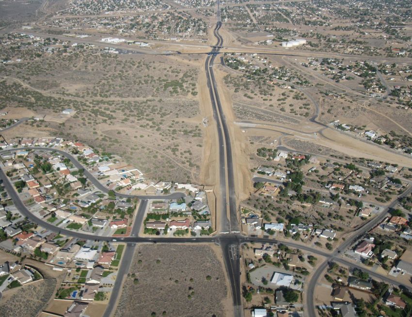
RANCHERO ROAD WIDENING PROJECT

I. PROJECT DESCRIPTION
Overview

With funding from the TIGER program, the City of Hesperia will complete the final phase of the
3-phase Ranchero Road Corridor Project in Hesperia, California to increase capacity for the more
than 14,000 motorists that travel this major arterial corridor daily. Building upon this corridor’s
first two phases, which included an Interchange at Ranchero Road and Interstate 15 (I-15) and a
railroad underpass at the Burlington Northern Santa Fe (BNSF) Railway railroad tracks near
Seventh Avenue, the City of Hesperia will leverage $27.3 million from public private partnerships
to widen a five mile stretch of this east-west, regionally significant corridor to:
    1) Broaden measures to improve safety conditions for all users.
    2) Promote commerce by facilitating freight movement along Ranchero Road between I-15
       and Hesperia’s industrial area and rail spur.
    3) Connect Hesperia’s and adjacent jurisdictions’ residents to destinations that bridge the
       divide and provide access to spur economic opportunity.
    4) Create a healthy and livable community by reducing congestion, thereby reducing
       greenhouse gas emissions.
    5) Improve safety response times for emergency vehicles on the recognized emergency route
       as well as improve public transit timeliness.
To meet these goals, Hesperia proposes to construct new capacity along five miles of Ranchero
Road from two to four lanes. Features include reconstruction of a new bridge over the California
Aqueduct and widening of an at-grade railroad crossing for Union Pacific Railroad (UPRR). Once
completed, this project will serve as a catalyst for new pedestrian-oriented development, support
mixed-use projects, and reinforce existing land use and zoning plans. The Ranchero Road
Widening Project will improve the quality of life for Hesperia residents and the region by fostering
a safe environment, reducing travel time for users, and improving accessibility to and around key
activity sectors in Hesperia and beyond. The project is recognized as a top regional priority and
part of a multi-agency project, with support from community organizations, elected officials, and
related stakeholders. The overall benefits of this project exceed the costs by a factor of 3.0, before
discounting.
The proposed improvements are part of the City of Hesperia’s 3-phase, $124 million Ranchero
Road Corridor Project that has already constructed $87 million in corridor improvements to
address an absolute transportation deficiency for east-west mobility and access to and from I-15
within the High Desert region of San Bernardino County, California. Phase III, the Ranchero Road
Widening Project, will improve safety, enhance economic opportunity, improve reliability,
preserve system assets, accelerate project delivery, and help create healthier, more livable
neighborhoods. Phase I of the Corridor, the BNSF Railway Underpass (Figure 1-2 below), opened
in 2013, and Phase II, the Ranchero Road Interchange at I-15 opened in 2015 (Figure 3-4 below).

 CITY OF HESPERIA                                                                                  1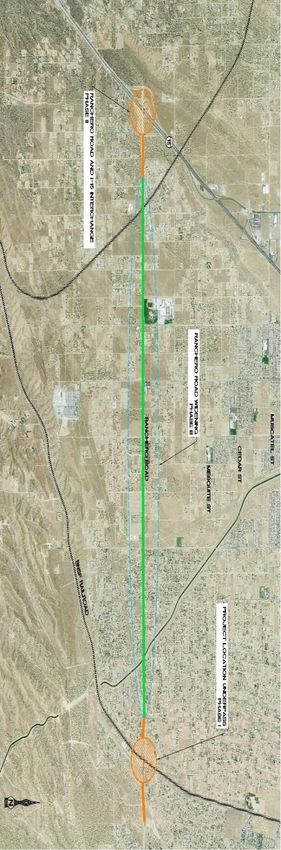
RANCHERO ROAD WIDENING PROJECT

      Figure 1. Phase I Underpass Rendering           Figure 2. Phase I Underpass Completed

        Figure 3. Phase II Interchange Rendering      Figure 4. Phase II Interchange Completed

Phase III, the Ranchero Road Widening Project, will cost $37 million. The City of Hesperia
(“City”) is requesting $9.7 million in FY 2017 TIGER Discretionary Grant (TIGER) funding
toward this $37 million project, of which $26 million is City cost and $11 million is County of San
Bernardino cost. The requested TIGER funding reflects a federal share of 37.3 percent of the City
cost and 26.2 percent of the total cost. The match will consist of local and private funding in the
form of advanced fees (Table 1).

              Description        TIGER Funding     Non-Federal Match              Total Project Cost
                  Amount           $9,700,000         $27,300,000                    $37,000,000
                 % Share                26.2%            73.8%
Table 1. Percentage share of project parties

 CITY OF HESPERIA                                                                                      2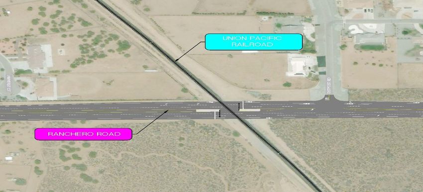
RANCHERO ROAD WIDENING PROJECT

Background

The City of Hesperia has experienced tremendous population growth since its incorporation in
1988, with most of it occurring on the southwest border where the Ranchero Road Corridor Project
is located. From a population of 43,400 at incorporation, to its current 93,778, growth is expected
to continue toward a projected population of 102,040 by 2020. The San Bernardino County
Transportation Authority (SBCTA) predicts that over the next 20 years Hesperia will experience
one of the largest percentages of population and job growth of any city in San Bernardino County.

This rapid growth has created an increase in traffic congestion. Combined with a lack of major
east-west corridors and interchanges in the High Desert, the once efficient transportation
infrastructure that was fully capable of handling the capacity of a smaller population is now
overwhelmed with daily gridlock.

Overcrowded capacity on each of the three east-west corridors in the region (Main Street, Bear
Valley, and Highway 18) has reduced mobility, increased congestion and ultimately diminished
the quality of life for all residents of the High Desert. An improved east-west corridor is
desperately needed to provide enhanced accessibility and traffic circulation in the southern Victor
Valley within the City of Hesperia and the County of San Bernardino. In addition, congestion
significantly undermines the environmental sustainability of communities. Given this, the City is
challenged to provide for a growing population while maintaining the quality of life, economic
vitality, and diverse environment that has made Hesperia a desirable place to live.

The Ranchero Road Corridor Project has been the City’s highest priority project since
incorporation in 1988 and is a crucial transportation infrastructure project that will benefit all the
communities in the region by easing congestion, providing more routing choices, and providing
another access point to I-15. Further, with the construction of the Highway 138 Realignment
Project by the California Department of Transportation (Caltrans), the Ranchero Road Corridor
will serve as an alternate route to I-15 during events causing lane closures and/or complete
shutdown of the Cajon Pass between Oak Hill Road and Highway 138. In addition, Ranchero Road
has a designation of an Other Critical Route with the San Bernardino County Office of Emergency
Services (Exhibit 1). Subsequent to the completion of the proposed project, Ranchero Road’s new
designation will be that of Secondary Critical Route. This is vital to the entire region in the event
of a catastrophic emergency.
Providing east-west access to I-15 has proven to be a challenge with the unique barriers of railways
and the California Aqueduct traversing the City. However, perseverance has led to the long
awaited completion of the first two phases of the Ranchero Road Corridor. Phase I, an
undercrossing at the BNSF Railway railroad tracks to connect Ranchero Road where it formerly
terminated on either side, now providing a through street. The $27 million project was completed
in June 2013 and provides direct access for motorists to reach the I-15 freeway.
Phase II, a $60 million project, constructed a freeway Interchange at Ranchero Road and I-15 to
include a 7-lane bridge over the freeway, on- ramps, off-ramps and other ancillary improvements.
The Ranchero Road Interchange Project was completed in March 2015, but not without challenges.
In May 2014, the Ranchero Road Freeway Overpass Bridge, nearing completion, was completely

 CITY OF HESPERIA                                                                                  3
RANCHERO ROAD WIDENING PROJECT
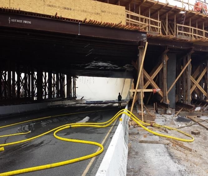
destroyed by a fire-related construction accident causing a shutdown of the I-15 in both directions
and the loss of all falsework for the bridge deck (Figures 5-6).
Figure 5. Fire at Ranchero Interchange at I-15 Figure 6. Fire at Ranchero Interchange at I-15
The City was resilient in their response to the set back and completed the new interchange just six
months later. Once completed, the interchange provided additional access through Hesperia and
helped achieve acceptable levels of traffic operation along I-15. The partial clover interchange
consists of a 7-lane overpass, on/off ramps for north and south traffic flows, realignment of both
Caliente Road and Mariposa Road, reconstruction of most western portion of Ranchero Road, and
traffic signalized intersections at Ranchero/Caliente and Ranchero/Mariposa.
Since the completion of Phase I and II of the Ranchero Road Corridor, extremely heavy traffic
congestion has been evident at the intersections of Maple Avenue and Cottonwood Avenue
traveling in both directions at various times throughout the day, especially during morning and
evening rush hour. The impacts at these intersections are substantially due to east/west traffic
patterns with minimal impact from north/south traffic patterns. Vehicles are backed-up for over a
mile due to a single path of travel in each direction. Vehicles must stop at two 4-way stop
intersections, which allows for only one east and one west traveling vehicle to pass through the
intersections at a time. Consequently, drivers are disobeying the law and driving down the
shoulders of the roadway to advance their position in line, or make right-hand turn movements.
These traffic conditions have raised concerns with staff and City Council, thus rendering
mitigation for these two intersections a high priority. Addressing this issue is vital for traffic
circulation on Ranchero Road.
In February 2017, the Hesperia City Council approved the widening of a small portion of Ranchero
Road along with re-striping the existing roadway to provide some temporary traffic congestion
relief at these intersections. However, this is not a long-term or optimal solution for effective
traffic movement with the amount of daily motorists.
CITY OF HESPERIA 4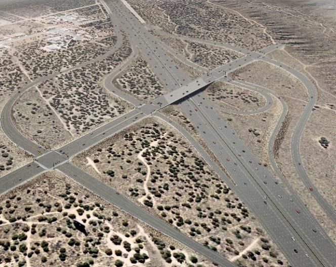
RANCHERO ROAD WIDENING PROJECT

Transportation Challenges
The City of Hesperia is bisected by various infrastructure assets such as the Southern California
Railroad, the UPRR and BNSF Railway. Approximately 110 trains travel through the City of
Hesperia per day as they connect between the Los Angeles and San Diego Metro areas to Las
Vegas and other states in the nation. The frequency of railroad traffic also creates additional hazard
due to the potential for accidental rail incidents. Over the last 20 years, there have been three
significant derailments in the Cajon Pass which affected the City and its transportation corridors.
In addition, the east branch of the Department of Water Resources (DWR) California Aqueduct -
which delivers water from northern California and flows into Silverwood Lake continuing through
the San Bernardino Mountains to other reservoirs - travels through the City of Hesperia, providing
a major water source for agencies serving nearby San Bernardino Mountains and Mojave Desert
areas.

Hesperia is bisected by U.S. Route 395 (US 395) and I-15, which connects southern California to
Las Vegas. State Highways 18 and 138 (SR 138) complete Hesperia’s transportation grid. New
residential and commercial developments within the High Desert region have exacerbated the
stress on current transportation infrastructure. Many Hesperia and neighboring jurisdiction
residents continue to travel to jobs out of the area, making commuter traffic access to I-15, US 395
and SR 138 an increasingly critical transportation problem.

East-west transportation corridors are severely lacking in the High Desert. The Main Street
Interchange project, which was once the only freeway access point and a major east-west corridor
in Hesperia, was completed in 2006 allowing for a smoother transition to and from I-15. Now,
with the construction of Phase I-Ranchero Road Underpass completed in June 2013, and Phase II-
Ranchero Road Interchange completed in March 2015, an additional east-west corridor access
point is helping to ease congestion for commuters region-wide.

Motorist circulation is difficult because of the number of vehicles traveling the corridor, narrow
roadway, and restrictive roadway geometry. The area surrounding Ranchero Road is congested
due to the high number of vehicles entering and leaving the corridor, especially near the high
school. In addition, the street network in the area is characterized by a lack of north-south through
streets and residential streets which are not appropriate for heavy travel. The before and after
Ranchero Road conditions near Oak Hills High School are provided in Figures 7-8 below.

 CITY OF HESPERIA                                                                                  5
RANCHERO ROAD WIDENING PROJECT

Figure 7. Oak Hills High School existing road

Figure 8. Oak Hills High School proposed road improvements

According to the 2014 Caltrans Annual Average Daily Traffic1 volumes, 152,000 vehicles travel
through the City each day while commuting from the High Desert to the Los Angeles metro areas
with traffic increasing dramatically each weekend while people travel through Hesperia to and
from Las Vegas.
Since completion of the undercrossing and interchange projects, traffic has also dramatically
increased on Ranchero Road. There is approximately an average of 14,275 vehicles traveling
Ranchero Road daily. Daily traffic counts for Ranchero Road and I-15 are outlined in Table 2
below.

1
    California Department of Transportation Annual Average Daily Traffic Report (2014)

    CITY OF HESPERIA                                                                      6
RANCHERO ROAD WIDENING PROJECT
Daily Traffic Counts
I-15 Oak Hill Road 256,000
I-15 Junction Route 395N 225,000
I-15 Joshua Street 205,000
I-15 Main Street 202,000
I-15 Bear Valley Road 185,000
Ranchero Road Mariposa 12,475
Ranchero Road Maple Avenue 15,297
Ranchero Road Escondido Avenue 14,287
Table 2. Daily Traffic Counts - Source: Caltrans, 2015 and Newport Traffic Studies, March 2016
An analysis of Citywide crash data occurring between 2006-2016 (Exhibit 2) shows that over a
10-year period there were over 3,400 traffic accidents, of which 273 involved bicyclists and
pedestrians and 131 resulted in fatalities. More specifically, along the Ranchero Road Corridor
over the same 10-year period there were 151 traffic accidents, of which, two involved bicyclist
and pedestrians and six resulted in fatalities (Appendix D). These findings emphasizes the need to
design and construct safer facilities for all travelers.
Adding to the above challenges, Hesperia’s development pattern has traditionally limited access
to jobs, healthcare, and education for the region’s most vulnerable populations. According to the
2015 U.S. Census American Community Survey, the neighborhoods in Hesperia constitute higher
than average rates of poverty, minorities, and educational attainment2. Almost 25 percent of the
area’s residents live at or below the poverty line, making the need for economic opportunities in
Hesperia that much more important. Further, these neighborhoods are majority minority
communities which tend to experience a disproportionate share of these financial hardships.
Motorist congestion is a daily problem for the City of Hesperia, affecting overall performance of
the facility and reducing operational efficiency. According to Walk Score3, Ranchero Road is car-
dependent so almost all errands require a vehicle. Commute times for this five mile stretch of
Ranchero Road is upward of 20 minutes during rush hour. The infrastructure improvements
planned for this project seek to address the following challenges:
Increase new capacity to reduce travel time and emergency response time;
Increase safety for all traffic movements by installing medians and turn pockets;
Provide a physical barrier between vehicular traffic from pedestrian and bicycle traffic by
installing curbs;
Improve safety and efficiency by installing traffic signals at three intersections;
Provide a safe and friendly facility to pedestrians and cyclists near the High School;
2
U.S. Census American Community Survey (2014)
3
www.walkscore.com
CITY OF HESPERIA 7RANCHERO ROAD WIDENING PROJECT
Help reduce localized flooding and associated traffic-related injuries and deaths by
improving the drainage system;
Facilitate freight movement to the City’s industrial and rail spur area;
Enhance visibility, connectivity, and accessibility to essential services and jobs;
Provide opportunity for improved public transit and school bus operations; and
Promote the potential for enhanced economic benefits.
In addition, the Ranchero Road Widening Project will result in increased travel reliability and
safety, thereby enhancing the transportation utility of this vital corridor, which is necessary to
ensure the economic sustainability of the High Desert area and the Southern California region as
a whole.
Regional/National Significance
I-15 is a major truck/commuter/inter-state travel route that originates at the junction of Interstate
5 (I-5) in San Diego, 10 miles north of the U.S./Mexico border, extends northeasterly across the
western half of the United States, and terminates in Sweetgrass, Montana, at the U.S./Canada
border. The Caltrans District 8 portion of the route starts at the Riverside/San Diego County Line
and ends at the Nevada State Line.
In Southern California, I-15 links commuters between the greater Los Angeles Area and the Inland
Empire cities including Rancho Cucamonga, Ontario, San Bernardino, Corona, Riverside, and
Temecula with the high desert communities of Hesperia, Apple Valley, Adelanto, Victorville, and
Barstow.
Its main use is for the inter-state/interregional movement of people and goods to and from the
greater Los Angeles Area. It is also a primary link between major economic centers and geographic
regions and is classified as a “High Emphasis” and “Gateway” route in the Interregional Road
System (IRRS). I-15 has also been included in the Federal Surface Transportation Assistance Act
national network for oversized trucks. Weekend and holiday recreational traffic on the route is
typically high because it serves as a connection to Las Vegas and the Colorado River area via
Interstate 40 (I-40).
In addition, I-15 serves as a major freeway linking to Interstate 10 (I-10), I-40, State Route (SR)
60, SR-210, SR-91, SR-58, and US-395. It also connects with SR-18, SR-138, SR-74, SR-66, and
SR-79.
Hesperia offers what is becoming a rarity in Southern California – City-owned rail property and
two prime 200+ acre sites, each controlled by a single entity (Figure 9), located in the City’s
industrial corridor.
CITY OF HESPERIA 8RANCHERO ROAD WIDENING PROJECT
Figure 9. G Avenue Industrial Rail Lead Track Park
When completed, the Ranchero Road Corridor Project will provide efficient and direct access to
this industrial corridor, thus increasing industrial opportunities in the City and improving the
movement of goods and services as well as providing job opportunities.
Ranchero Road also provides access to Hesperia Airport, a public-use and privately-owned airport,
which is located off East Santa Fe Avenue on the south side of Ranchero Road. Classified in the
National Plan of Integrated Airport System as a General Aviation, basic utility airport, Hesperia
Airport also serves as the nearest Flight Service Station (FSS). As an FSS, the airport provides
information and services to aircraft pilots before, during, and after flights, and provides assistance
during emergencies. The project will improve efficiency of emergency services vehicles
throughout the area, including the airport during emergency situations. Further, Ranchero Road
provides goods transport to the aircraft and military manufacturers adjacent to the airport. The
airport also accommodates a Flight for Life Emergency Medical Air Transit helicopter that serves
the region. The Ranchero Road Widening Project improvements can provide for prompt pilot
response to the helicopter pad as well as patient transport via ambulance to the Flight for Life unit.
Economically, the Ranchero Road Widening Project will increase property values and create
sustainable jobs resulting from the ignition of new development. Over 265 acres of vacant land are
present today along Ranchero Road and near the Interchange. The project will attract and re-
energize development and emphasize sustainable growth.
Key Component of a Larger Effort to Revitalize Ranchero Road
The Ranchero Road Widening Project is a key element in a larger effort to promote commerce and
increase land value in Hesperia. These larger efforts also have a focus on providing “ladders of
opportunity” for residents of Hesperia and surrounding communities. The project will make these
broader development efforts more successful and impactful to residents and the City as a whole.
The following identifies some of these expanding efforts:
Development of Adjacent 100-Acres
The proposed development project site is located within the City’s Planning Area 13 near
Ranchero Road and the I-15. The development site in the interchange area consists of over 100
acres which is being marketed for regional and destination oriented retail and entertainment
venues. Some utilities to serve this area have been installed in Mariposa Road and Caliente Road
CITY OF HESPERIA 9RANCHERO ROAD WIDENING PROJECT
near the Ranchero Road Interchange of the I-15 as part of the Ranchero Interchange project. The
UPRR track is approximately 1,400 feet northeast of the existing sewer lines near the project site,
and there is a 20-foot deep wash east of Mariposa Road on Ranchero Road. Figure 10 below is the
vicinity map of the development site.
Figure 10. Ranchero Road Interstate 15 Interchange Development Location
Private Development
In 2016, a master planned community of residential and mixed-use development on approximately
9,365 acres was approved by the Hesperia City Council. The Tapestry Development is
approximately eight miles east of I-15 along SR 138. State Route 173 generally serves as the
project site’s southern and eastern boundary. The northerly boundary is Ranchero Road. Terra
Verde Group, LLC, the developer of the Tapestry Project proposes a maximum of 16,196
residential units with a mix of densities ranging from very low density and equestrian to high
density and mixed-use. The majority of the residential units would be low/medium density.
Ranchero Road will serve as their primary access to I-15, connecting these residents to jobs, goods
and services throughout the High Desert and beyond.
In addition to residential uses, the Tapestry Development will include the following:
Two mixed-use town centers totaling approximately 94 acres.
Approximately 387 acres of park land, including community and neighborhood parks,
sports fields, passive recreational open space areas, and water features.
An extensive trail system including trails and enhanced pathways adjacent to streets, and
off-street, and equestrian trails totaling approximately 59 miles (94 acres), and
neighborhood entry and concrete sidewalk connections totaling approximately 107 miles
(138 acres).
CITY OF HESPERIA 10RANCHERO ROAD WIDENING PROJECT
Eight elementary schools, two middle schools, and two high schools totaling
approximately 262 acres of school uses.
Public and civic facilities (e.g., post office, library branch, fire stations, etc.).
A wastewater treatment facility and lift stations.
Roadways, drainage facilities, domestic and recycled water infrastructure, and other
associated infrastructure.
Preservation of approximately 3,533 acres of open space, including an approximately 523-
acre conservation easement and an approximately 81-acre Serrano Heritage Preserve (with
an approximately 72-acre overlap between these two categories), as well as approximately
58 acres of recycled water storage ponds.
Ladders of Opportunity
Both businesses and residents prize the City of Hesperia’s strategic location at the top of the Cajon
Pass, providing ease of accessibility to Hesperia’s 17 miles of prime freeway frontage and direct
access to Ranchero Road by way of the new interchange.
Hesperia is a diverse city covering more than 75 square miles of various urban areas with industrial
to retail and large residential areas. There are significant areas of land that are undeveloped or
vacant. With almost 300,000 residents living in the Victor Valley, Hesperia provides the prime
location for economic activity. This project will enable retail service industries such as grocery
and prescription drug stores to locate in this area. These strategically-located services would allow
for a shorter drive time and reduce congestion throughout the City.
In Hesperia, access to everyday needs often requires driving a vehicle. Costs may make it difficult
for Hesperia’s diverse population to safely reach their destinations. The cost of owning and
operating one car can be upwards of $9,000 annually4 (Exhibit 3), making up nearly 20 percent of
the median household income in Hesperia.5 In response, the Ranchero Road Widening Project
fully encompasses the USDOT concept of “ladders of opportunity.” The project will transform
Hesperia’s transportation environment by constructing a critical facility to connect the community
to centers of employment, education, essential services, and stimulate commerce.
Project Details
The Ranchero Road Widening Project will consist of widening five miles of Ranchero Road from
two to four lanes to include features such as demolition of the existing bridge and construction of
a new bridge over the DWR California Aqueduct, widening of an UPRR at-grade crossing, and
signalization of three intersections, two of which will require accommodating existing high voltage
transmission lines belonging to Southern California Edison. (Figure 11).
4
American Automobile Association, Your Driving Costs (2012)
5
US Census American Community Survey (2015)
CITY OF HESPERIA 11RANCHERO ROAD WIDENING PROJECT
Figure 11. Ranchero Road Widening Project Map
The proposed new capacity will include the following elements:
1. Curb to curb widening ranges from 63’ to 92’ to accommodate two travel lanes in each
direction;
2. Construction of nine turn pockets;
3. Striped median providing safe turning movements at 13 intersections;
4. Installation of traffic signals located at 7th Avenue, Cottonwood Avenue and Maple Avenue
(Figure 12-14);
Figure 12. 7th Avenue Figure 13. Cottonwood Avenue Figure 14. Maple Avenue
CITY OF HESPERIA 12RANCHERO ROAD WIDENING PROJECT
5. Widen UPRR at-grade railway crossing on the west by constructing three lanes in each
direction, including 4-foot (4’) wide bike lanes and new crossing arms and flashing beacons
(Figures 15 - 18);
Figures 15 – 17. Existing Conditions of UPRR At-Grade Railway Crossing
Figures 18. Rendering of the UPRR At-Grade Railway Crossing (Exhibit 4)
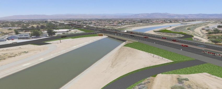
6. Widen and raise the California Aqueduct Bridge crossing to a 3-foot (3’) minimum vertical
clearance from top of canal liner to bottom of bridge soffit and a 5-foot (5’) minimum
horizontal clearance from face of abutment to the top of the canal liner to accommodate
three lanes of traffic in each direction and add a raised median and bike/pedestrian pathway
(Figure 19-21).
CITY OF HESPERIA 13RANCHERO ROAD WIDENING PROJECT
Figure 19-20. Existing condition of the California Aqueduct Bridge Crossing
Figure 21. Rendering of the California Aqueduct Bridge Crossing (Exhibit 4)
7. Improve drainage system in three locations to extend existing storm drain pipes for a wider
roadway to convey storm flows safely under the roadway, protecting the safety of
motorists, pedestrians, and the roadway. Further, a new drainage system within the
aqueduct bridge will allow storm flows to continue across the aqueduct preventing storm
water from entering the aqueduct as it does today. Thus minimizing the potential for
pollutants carried in storm water to degrade the quality of drinking water DWR transports
to southern California via the aqueduct.
CITY OF HESPERIA 14RANCHERO ROAD WIDENING PROJECT
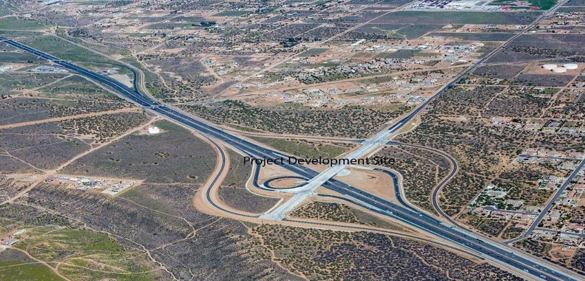
II. PROJECT LOCATION
Geospatial Location and Map
Bisected by I-15 and U.S. 395, Hesperia, California sits at the foot of the San Bernardino National
Forest, 35 miles north of San Bernardino, 90 miles northeast of Los Angeles and 195 miles south
of Las Vegas, Nevada. Located in the Victor Valley region of the Mojave Desert, Hesperia is
located in an area that is regionally referred to as the High Desert due to its elevation of between
3,200 and 4,000 feet above mean sea level (Exhibit 5). As of 2017, the population of Hesperia is
93,778, making it the second most populous city in the High Desert. The City of Hesperia is located
within a boundary of a Census-designated Urbanized Area for Victorville-Hesperia.
A unique consideration for Hesperia are the several north-south obstructions that traverse the City.
One of these barriers is the BNSF railway lines, which bisects Hesperia from north to south. This
railway is a major commerce corridor with 110 trains passing through Hesperia each day
transporting a variety of goods from the ports in Long Beach and Los Angeles to the western and
central portions of the U.S. The DWR California Aqueduct divides the City from the northwest
to the southeast and is utilized to provide drinking water to Southern California. Two sets of
Southern California Edison high voltage transmission lines and ancillary easements also pass
through the City north to south and northeast to south. In addition, the Mojave River, which runs
north to south traverses through our region along the eastern border of Hesperia with I-15 and
Highway 395 each bisecting the City near the western border. These impediments make it
challenging to provide east-west connectivity.
All elements of the Ranchero Road Widening Project will be completed within the jurisdictions
of the City of Hesperia and County of San Bernardino. The proposed project's western limits along
Ranchero Road begin approximately 1,000 feet east of Mariposa Road and extend to Seventh
Avenue to the east for approximately five miles. Within the project limits, approximately three
miles are within the County's jurisdiction, from the westerly project limits to Topaz Avenue, and
the City’s jurisdiction consists of approximately two miles of the proposed project from Topaz
Avenue to Seventh Avenue (Figure 22 below and Exhibit 6).
Figure 22. Location of Project Site (in green outline)
CITY OF HESPERIA 15RANCHERO ROAD WIDENING PROJECT
Demographics
In 1980, Hesperia was a small unincorporated community containing only a few stoplights and
13,540 people—a number that increased to 62,582 by 2000. Hesperia’s growth between the years
2000 and 2010 was a dramatic 43.9 percent. During the same time period, the population growth
in the County was 21.5 percent; the State, 11.8 percent and the nation, 9.8 percent. Today,
Hesperia is a thriving community of 93,778 residents, with a projected population of 102,040 by
the year 2020. Its location between Los Angeles and Las Vegas gives it strategic economic
development importance for the region (Figure 23).
Regionally speaking, the entire Victor Valley area of the High Desert exceeds 310,000 people,
which offers an extensive trade market area and labor pool. Population, traffic counts, workforce,
and new commercial developments add to the vitality of Hesperia as a location of choice for retail,
commercial and industrial business.
Figure 23. Hesperia location in relation to neighboring communities
CITY OF HESPERIA 16RANCHERO ROAD WIDENING PROJECT
Employment
Hesperia’s growing economy is characterized by a diverse mix of traditional and emerging
industries. Its labor pool consists of 37,259 productive and motivated workers 16 years and older
seeking employment with companies that can provide a rewarding and stable environment. Major
employers include the warehouse and distribution field, manufacturing, construction, education,
restaurant, and government.
A longtime jobs-housing imbalance has existed in the region, created by the lower cost of living
in conjunction with relatively short commuting distances to job centers to the south in the Inland
Empire. Because of its proximity to the Cajon Pass, Hesperia is the most commuter-friendly
community in the High Desert, with the average commute to work being just under 40 minutes
each way. However, the largest percentage of residents (25.7 percent) spend 15 to 29 minutes
driving to work. Table 3 shows jurisdiction comparisons for Hesperia and the neighboring
communities.6
City of City of Town of City of
Hesperia Victorville Apple Adelanto
Valley
Demographics (2011-2015 U.S. Census Bureau)
Population 93,778 120,703 71,083 32,059
% Unemployment Rate 6.9% 6.8% 7.34% 46.0%
% People Below Poverty Level 24.8% 26% 20.6% 40.3%
Median Household Income $48,639 45,894 44,874 33,298
Means of Transportation to Work
Workers 16 years and older 37,259 37,828 23,451 21,331
Vehicle 27,612 34,724 21,558 6,834
Public Transportation 248 413 177 95
Walking 197 262 252 71
Other (biking, taxi, worked at 2,048 2,429 1,464 385
home)
Occupied Housing Units 26,253 31,886 23,727 7,732
One Vehicle Available 7,530 10,261 7,954 2,923
Table 3. Statistical information for Hesperia and the neighboring communities.
Hesperia households qualify as Disadvantaged Communities (DAC) with a median household
income (MHI) of $48,639, which is 75.4 percent of California’s MHI of $64,500. Although
Hesperia’s previously strong housing market was not immune as the housing boom stalled and
values began free-falling in late 2007, today, Hesperia enjoys a 64.1 percent owner occupied
housing rate. In Figure 24 below, Hesperia statistical information is provided7.
6
U.S. Census American Community Survey (2015)
7
www.cityofhesperia.us/demographics
CITY OF HESPERIA 17RANCHERO ROAD WIDENING PROJECT
Figure 24. Hesperia at a Glance
CITY OF HESPERIA 18RANCHERO ROAD WIDENING PROJECT
III. GRANT FUNDS, SOURCES AND USES OF
PROJECT FUNDS
The total project cost is estimated at $37 million, of which, $9.7 million is requested TIGER grant
funding and the remaining $27.3 million from various public and private sources. As discussed in
other sections of this application, the project proponents include the City ($9.6 million), San
Bernardino County ($11.0 million) and SBCTA ($6.7 million). The City has agreed with local
developers to assist with its share of the project costs adding the private source component to the
project funding. TIGER grant funding will pay for approximately 26 percent of the total project
cost, local match funding will pay for 44 percent, which includes SBCTA funding, combined with
regional funding of 30 percent. For the private funding, the City is drafting a Development
Agreement with Terra Verde to provide amounts prior to 2019. Regional agencies are
contractually obligated to furnish its portions of the project amounts upon City execution of the
project.
A summary of total project costs by source and cost share is presented in Table 4 below.
Additionally, a summary of project funding uses is presented in Table 5 below. As shown, the
City has completed project approvals and CEQA environmental compliance, so no additional
funding is required to complete with the exception of updating to National Environmental Policy
Act (NEPA) compliance. Of note, all grant funds will be directly applied to construction. Lastly,
a summary of construction costs in presented in Table 6 below. Detailed construction cost
estimates and project budgets are enclosed as Appendix B.
Project Funding Sources Estimated Percent
Costs
Federal Share
TIGER Discretionary Grant Program $ 9,700,000 26%
Non-Federal Share
City of Hesperia $ 9,600,000 26%
San Bernardino County Transportation Authority-City $ 6,700,000 18%
County of San Bernardino $4,565,000 12%
San Bernardino County Transportation Authority-County $ 6,435,000 18%
Total $37,000,000 100%
Table 4. Sources of Funds
Project Funding Uses TIGER Non-Federal Total
Approval and Environmental
$ - $ - $ -
Documents
Specifications and Estimate $ - $ 2,860,000 $ 2,860,000
Right-of-Way $ - $ 3,860,000 $ 3,860,000
Construction $ 9,700,000 $20,580,000 $30,280,000
Total $9,700,000 $27,300,000 $37,000,000
Table 5. Project Funding Uses
CITY OF HESPERIA 19RANCHERO ROAD WIDENING PROJECT
Description $ Amount Percent
Roadway Construction $ 16,470,000 45%
Bridge Construction $ 10,810,000 29%
Right-of-Way/Other $ 3,860,000 10%
Design $ 2,860,000 8%
Construction Management $ 3,000,000 8%
Project Total: $ 37,000,000 100%
Table 6: Construction Costs
IV. MERIT CRITERIA
Primary Selection Criteria
Safety
Completing the Ranchero Road Widening Project will provide for increased safety for all users in
the area, including pedestrians, bicyclists, transit riders and commuters of all ages between the
Ranchero/I-15 Interchange and the Underpass near Seventh Avenue. Sidewalks are used where
possible by existing pedestrians, but pedestrians and cyclists spend much of their trips in mixed
traffic. The Project would mitigate the insecurity felt by high school student walkers and cyclists
traveling in the area in mixed traffic. The improvements contained in this project will reduce
response time for emergency response vehicles and improve access to a Flight for Life Emergency
Medical Air Transit helicopter for the region located just south of Ranchero Road at the Hesperia
Airport. Further, Ranchero Road is designated as an Other Critical Route with the County of San
Bernardino Office of Emergency Services. Once the improvements are complete, the status of the
corridor will be elevated to a Secondary Critical Route which is vital to the Victor Valley Region
in the event of a catastrophic emergency.
The total value of the safety benefit is estimated to be approximately $3.2 million annually
(Appendix A, Table 3). This benefit and the accident reduction benefits generated by the mitigation
of other hazards results in $30.0 million in overall safety benefits, assuming a 7 percent discount
rate (Appendix A, Table 7). It should be noted that accident reduction benefits also would be
expected as existing automobile drivers are encouraged to walk or bike to activity centers, in lieu
of driving. These benefits are not monetized nor included in the benefit-cost analysis, so the
accident reduction benefits estimate is likely conservative.
State of Good Repair
Considering that the transportation systems were constructed prior to the City’s incorporation in
1988, the existing systems are in a state of disrepair. Existing roadway infrastructure is in need of
replacement and the transportation systems do not include sufficient capacity for existing and
future transportation network efficiency, mobility of goods, accessibility and mobility of people,
or economic growth. If left unimproved, economic development opportunities will be significantly
impaired. Current traffic conditions create congestion on the I-15 consequently creating
significantly greater congestion along the regional trade corridor. In addition, some areas beyond
state right-of-way do not include bicycle or pedestrian improvements. The proposed project will
develop a corridor to facilitate traffic movement without significant delays at all project
CITY OF HESPERIA 20RANCHERO ROAD WIDENING PROJECT intersections. In addition, the project includes construction of both bicycle and pedestrian improvements to encourage non-vehicular modes of transportation and to encourage the use of public transportation. The project includes primarily asphalt concrete improvements that are typically resilient and will minimize life-cycle costs. Completed improvements will be included in infrastructure maintenance programs funded through Measure I (San Bernardino County), local gas tax revenue and other revenue sources to ensure project life in perpetuity. The project is appropriately capitalized up front and uses asset management approaches that optimize its long-term cost structure. In addition, the project has a sustainable source of revenue for operations and maintenance of the project. The project improves the transportation asset’s ability to withstand probable occurrence or recurrence of an emergency or major disaster or other impacts of climate change. Finally, the project contributes to improvement in the overall reliability of a multimodal transportation system that serves all users. Economic Competitiveness The City of Hesperia is an economically distressed area. The project will facilitate growth that will create economic activity, development, and jobs (both medium term during project development and long term). The project will enhance reliability of movement of workers and goods by reduction of congestion along the Ranchero Road Corridor and I-15, a regional goods movement corridor. As discussed in the project description, the Ranchero Road Widening Project will enhance mobility for residents, seniors, students, and workforce by providing safe access to all users. Amplified demands of east-west access points have created a vital need to improve all forms of mobility, improve road serviceability, increase transportation efficiency, promote greater safety for a growing employment base, and develop a proposal that will meet state, regional and local transportation goals. The greater length of Ranchero Road is residential, delivering its population to employment centers in, near, and generally beyond the High Desert communities. In fact, the commute can extend into the Greater Los Angeles Area and Inland Empire of San Bernardino, Ontario, Riverside and beyond. The project’s location offers the ability to provide support services and extend the delivery of goods and services. From an economic perspective, the lower property values and convenient access to freeways and rail lines have made Hesperia an ideal location for manufacturing and industrial facilities, retail centers, warehouses, rail yards, and distribution centers. In fact, the Ranchero Road Interchange is zoned for regional commercial uses and ideally situated within close proximity to transportation corridors leading to mountain resorts including Big Bear and Mammoth. This I-15 intersection is destined to become a prime retail destination, particularly for outdoor lifestyle specialty stores for recreational sports such as camping, skiing, fishing, hunting, related apparel and more. The socio-economic demographics of the project area largely account for workers who fill positions synonymous with these types of employment centers. This demand will continue to grow as future retail, commercial and manufacturing industries develop within proximity to this project CITY OF HESPERIA 21
RANCHERO ROAD WIDENING PROJECT

site. More efficient movement of traffic accessing Ranchero Road from the I-15 will provide long-
term benefits resulting from this completed project.

The Tapestry master-planned community on the east end of the project area will provide significant
opportunities for both medium-term construction jobs and greater long-term regional employment
opportunities. Included within this development are 16,196 residential units, and 94 acres of mixed
use town centers, along with 387 acres of park land, 59 miles of trails, and connectivity to the I-
15 freeway corridor.

Environmental Sustainability
The project makes good business sense and good environmental sense. The project aims to balance
economic, social and environmental objectives of the Hesperia community.

The Ranchero Road Widening Project will promote and support a change of travel patterns that
will in turn reduce vehicle miles traveled because trips can be completed with less congestion and
subsequent vehicular idling. The project will provide some savings by reducing greenhouse gas
emissions as well as wear and tear on roadways and motor vehicles due to reduced vehicle idling
in addition to other benefits by implementing sustainability initiatives. These changes in overall
travel behaviors result in less oil dependence and reduced emissions. The travel time savings is
just under $2.8 million annually (Appendix A, Table 4). Additionally, the project will provide an
average annual reduction in CO2 emissions of 2,356 Metric Tons per year (Appendix A, Table 8).

Environmental sustainability benefits are also a result of the project’s implementation attributes.
The project itself requires negligible right-of-way acquisition because the widening will occur
within the majority of existing City right-of-way.

Quality of Life
Limited employment options in the region mean that many residents of Hesperia and neighboring
communities need to travel long distances to the I-15, then utilize I-15 to reach regional
employment centers and employment outside the region. The area’s strong dependence on
vehicular travel to reach these opportunities, coupled with a constrained street network, result in
many lengthy travel times.

Further, essential services such as major medical centers are located outside the City.
Improvements to Ranchero Road provides direct access to I-15 and resulting north or south travel
to major medical services.

Secondary Selection Criteria

Innovation
The design standards of the project will ensure that this first route is operable with other cross
streets and rail projects envisioned by the City of Hesperia. Updated zoning regulations now
require active and productive land uses, wider sidewalks, and buildings that are designed to engage
with the surrounding environment.

 CITY OF HESPERIA                                                                              22
RANCHERO ROAD WIDENING PROJECT

Partnership
The City is the lead agency partnering with the County of San Bernardino, SBCTA, and a private
developer to complete the project. As noted above, three miles of the project are located within
the unincorporated areas of San Bernardino County. That portion of the project will be funded by
County development impact fee funds. The partnership is documented in an interagency
agreement. Supporting documents are available on the City’s on the City's TIGER Grant website
at http://www.cityofhesperia.us/TigerGrant.

CITY OF HESPERIA
As the lead agency, the City will carry out the Ranchero Road Widening Project. Hesperia has
successfully completed several multimodal transportation related improvement projects, two of
which were the first two phases of the Ranchero Road Corridor as previously mentioned. Other
projects include the “G” Avenue Industrial Rail Lead Track and Drainage Channel Project, Main
Street/I-15 Interchange, Hesperia Township Revitalization on Spruce and Smoke Tree Streets,
Main Street Bridge Rehabilitation, installation of bike paths throughout the City, and ADA
compliant access ramp reconstruction.

The City is a general law City operating under a Council-Manager form of government with
authority and responsibility for local legislative acts vested in the Council with a total Fiscal Year
2017-18 budget of $95 million.

SAN BERNARDINO COUNTY
San Bernardino County is the largest county in the U.S. with over 20,000 square miles of service
area. The County’s Board of Supervisors is charged with providing essential services ranging from
infrastructure and water to health services and public safety in unincorporated areas within its
boundaries. The County has been partnering with the City on this project since 2011.

SAN BERNARDINO COUNTY TRANSPORTATION AUTHORITY
SBCTA is the regional transportation authority in San Bernardino County tasked with planning
multi-modal transportation, programming State and Federal funds for regional projects, and
managing the voter-approved transportation sales tax for the entire County.

Having identified the project’s regional significance, SBCTA will fund 41.3 percent of the City’s
and 58.5 percent of the County’s total project costs. SBCTA will use gas tax and Measure I (local
gas tax) to fund its portion of the project. The funding commitment to the project is documented
in Project Funding Agreements with SBCTA.

TERRA VERDE DEVELOPMENT, LLC
Terra Verde Development, LLC is a private developer having an approved master-planned
community in the City as previously described in Section I. Through Hesperia City Council
approval, the Terra Verde Development has committed to contribute $9 million to the project,
which will be documented by a Development Agreement.

 CITY OF HESPERIA                                                                                 23
RANCHERO ROAD WIDENING PROJECT

V. PROJECT READINESS
Technical Feasibility

As demonstrated by the completion of Phase I, the BNSF Railway Undercrossing and Phase II,
the interchange at I-15 of the Ranchero Corridor Project, the City has experience in delivering
extremely complex projects and overcoming unique challenges such as the various barriers that
traverse the City as described in Section II. Effective planning and coordination with multiple
permitting agencies, municipal agencies and utility providers is essential to deliver a successful
project within time constraints and budget.

Improvement design for the Ranchero Road Widening Project is in accordance with Caltrans
Standard Guidelines, City Standards, County of San Bernardino Standards, DWR Standard
Guidelines, and other applicable local, state, and federal requirements. The improvements to be
constructed are as specified under Project Details. Cost estimates are based on completed
engineered construction drawings for the roadway improvements and preliminary design plans for
the aqueduct crossing.

Since the majority of improvements can be installed within existing right-of-way, little right-of-
way is required for this project with the majority being for the aqueduct bridge. The City is in the
process of acquiring the right-of-way for the aqueduct bridge with anticipated completion in
summer 2018.

Project Schedule

The project schedule provides sufficient time to ensure that unexpected delays will not put TIGER
Grant funds at risk of expiring before they are obligated; the project can begin construction quickly
upon receipt of a TIGER Grant; the grant funds will be spent steadily and expeditiously once
construction starts (Table 7).

                                                                                  Anticipated
 Milestones                                        Status                      Start     Complete
 Environmental Compliance (CEQA)                   Complete
 Environmental Compliance (NEPA)                   Pending Grant Award        Jan. 2018     Jul. 2018
 Design (Roadway)                                  Complete
 Design (Aqueduct Bridge)                          Near Completion                         Dec. 2017
 Design (At Grade RR Crossing)                                               Dec. 2017     Sept. 2018
 Right-of-Way Acquisition (Aqueduct)               In Progress                             Aug. 2018
 Permits (Aqueduct Bridge)                                                    Jan. 2018    Apr. 2018
 Permits (Railroad Crossing)                                                 Sept. 2018     Oct. 2018
 Caltrans Authorization to Proceed                                            Oct. 2018     Oct. 2019
 Bidding and Procurement (Roadway)                                           Nov. 2019      Feb. 2020
 Bidding and Procurement (Aqueduct Bridge)                                    Jun. 2020    Sept. 2020
 Bidding and Procurement (Railroad Crossing)                                  Oct. 2020     Jan. 2021

 CITY OF HESPERIA                                                                                24
RANCHERO ROAD WIDENING PROJECT Construction (Roadway) Mar. 2020 Dec. 2020 Construction (Aqueduct Bridge) Oct. 2020 Jan. 2022 Construction (At Grade RR Crossing) Feb. 2021 Aug. 2021 Project Closeout Mar. 2022 Sept. 2022 Table 7. Project Schedule The schedule demonstrates that all necessary pre-construction activities will be completed by October 2018, and that all funding will be obligated by October 2019 or earlier. Required Approvals An Environmental Impact Report (EIR) was complete in June of 2013 in compliance with the California Environmental Quality Act (CEQA). The completed EIR is available on the City's TIGER Grant website at http://www.cityofhesperia.us/TigerGrant. Due to the elimination of Redevelopment Agency (RDA) funds in California, the project was on hold for a period. Because the use of RDA funds only required a CEQA document and there were no Federal funding sources utilized at the time, the City was able to forego initiation of the NEPA process. Should the City be successful in securing a TIGER Grant, the necessary environmental updates consistent with NEPA will be processed. Since the CEQA-compliant EIR was completed, the City can expedite the NEPA process without delay to the obligation of grant funding. Construction drawings for the aqueduct bridge require approval by DWR and permit issuance. Design is near completion and slated for subsequent approval in spring 2018. UPRR has oversight of the at grade railroad crossing with approval to follow in fall 2018. If successful in receiving a TIGER Grant, construction activities must receive authorization to proceed from Caltrans due to the utilization of a Federal funding source. All Federal-aid transportation projects in California must go through the Caltrans authorization process. The City will coordinate the approval process in accordance with Caltrans guidelines. Said approval will mark the obligation of TIGER funds received. Assessment of Project Risks and Mitigation Strategies This project has negligible risk because the roadway portion of the project is essentially shovel- ready with the exception of the environmental update to meet NEPA requirements. As previously stated, this will be expedited to avoid delay of grant funding obligation. Construction will be segmented into stages (street improvements, aqueduct crossing, at grade crossing) to avoid conflicts with construction staging, equipment and work performance. In the unlikely event the City is still awaiting DWR or UPPR approval for the aqueduct bridge and at grade crossing respectively, the order of each construction stage may be reprioritized. Upon NEPA clearance, construction of the street improvements may commence in advance of the other two structures. CITY OF HESPERIA 25
You can also read