Transport Strategy refresh - Background paper Public Transport Network March 2018 - Amazon AWS
←
→
Page content transcription
If your browser does not render page correctly, please read the page content below
Transport Strategy refresh

Background paper

Public Transport Network
March 2018
Dr John Stone (University of Melbourne)
Dr Ian Woodcock (RMIT)

                                          1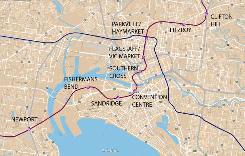
This report has been prepared by Dr John Stone (University of Melbourne) and Dr Ian
Woodcock (RMIT) as independent advice for the City of Melbourne.
The aim of the report is to encourage public conversation and to inform the City of
Melbourne’s forthcoming Transport Strategy refresh.

                                                                                      2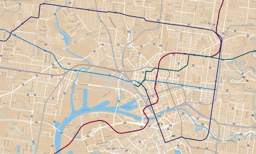
Contents
1.      Introduction ......................................................................................................................................... 5
2.      Current performance ........................................................................................................................... 6
     2.1.    Mode share ................................................................................................................................... 6
     2.2.    Overcrowding ................................................................................................................................ 9
     2.3.    Reliability and speed ..................................................................................................................... 9
3.      Better public transport for the City of Melbourne: Key issues in brief ............................................... 10
4.      Public transport issues & options ...................................................................................................... 11
     4.1.    Significant growth is expected in public transport demand ......................................................... 11
     4.2.    New public transport capacity is required beyond current Victorian Government commitments 11
     4.3.    Demand will exceed new capacity from Melbourne Metro Rail Stage 1 ..................................... 11
        4.3.1.       Priorities for radial rail expansion ........................................................................................ 13
        4.3.2.       A denser and better connected inner-city tram and bus network ....................................... 21
        4.3.3.       Suburban orbital routes ....................................................................................................... 26
     4.4.    Why metropolitan transport planning matters: the need for an integrated transport plan........... 30
     4.5.    Getting value for money from Victorian Government spending on public transport ................... 31
     4.6.    Providing space for pedestrian movement related to public transport access ........................... 32
5.      Summary & Recommendations ........................................................................................................ 34

                                                                                                                                                             3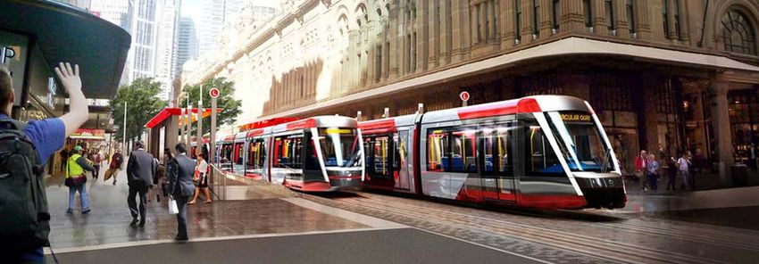
List of Illustrations

TABLES
1.     Percentage mode share splits for the journey to work in 2011 and 2016                      4

FIGURES
1.     Journey to work mode share comparison for the Hoddle Grid and remainder of
       Melbourne LGA                                                                              5
2.     Mode share for travel university students in Inner Melbourne                               5
3.     Trip purpose and mode by region in greater Melbourne                                       6
4.     2032 Metropolitan Rail Network                                                             10
5.     Current capacity improvements will not meet project growth in demand                       11
6.     MELBOURNE METRO RAIL 1 and 2 alignments                                                    12
7.     Fishermans Bend Draft Framework – Possible MM2 Stations                                    13
8.     Melbourne Metro Rail 2 (MMR2) – proposed stations                                          14
9.     Concentrations of suburban jobs (i.e. excluding the inner and central city), showing the
       importance of the airport precinct                                                         15
10.    Comparison of possible Melbourne airport rail alignments                                   16
11.    Melbourne Metro 3? – a northwest metro connecting the airport to the CBD                   17
12.    Options to improve public transport access to Melbourne Airport                            18
13.    Greater Vienna, SNAMUTS accessibility analysis                                             20
14.    Greater Melbourne, SNAMUTS accessibility analysis                                          21
15.    Comparison of Melbourne and Vienna: fixed route public transport networks                  22
16.    Melbourne’s trains and trams radiate from the central city area like ‘spokes’              24
17     Melbourne’s orbital and radial SmartBus routes                                             25
18     Gold Coast Light Rail                                                                      26
19     Sydney Light Rail                                                                          27
20     Inner and central city view of proposed new LRT network                                    27
21     Suburban Light Rail – priority corridors                                                   28
22     Numbers of trains requiring platform re-allocation (transposal) at Flinders St             30

                                                                                                       4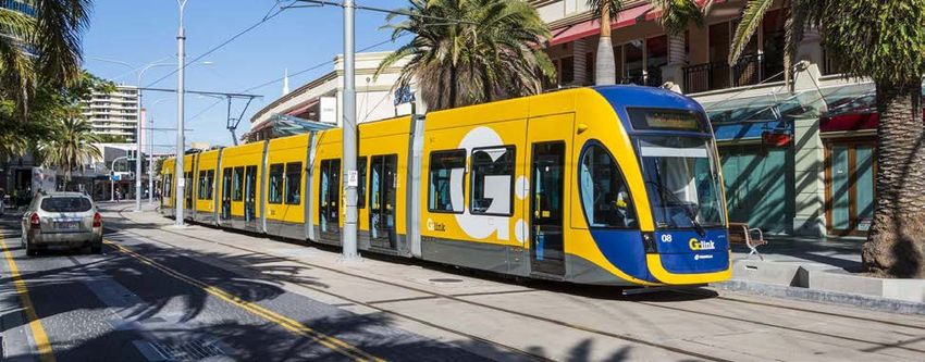
1. INTRODUCTION
This paper is one of a series of discussion papers commissioned by the City of
Melbourne to stimulate public debate and to inform the City of Melbourne’s Transport
Strategy Refresh. It provides data and analysis on the current performance and
prospects for improvement of Melbourne’s public transport networks as these affect the
City of Melbourne.
In its 2012 Transport Strategy, the City of Melbourne set clear objectives to improve
access from wider metropolitan Melbourne and the regions by public transport, cycling
and walking. These ambitions included:
   •   Creation of a ‘go anywhere, anytime’ public transport network for inner
       Melbourne.
   •   Support for public transport, walking and cycling as the dominant modes of
       transport in inner Melbourne.
In supporting the work of the City of Melbourne to re-affirm these objectives and to
determine appropriate actions for 2018 and beyond, this discussion paper will examine
current issues with Melbourne’s metropolitan public transport network and indicate
where we believe the City of Melbourne, though its advocacy and through work within
its own jurisdiction, might most effectively work towards practical solutions.
The Victorian Government is largely responsible for planning and funding the public
transport system, which is operated by private companies under franchises and other
contractual arrangements. However, Central Melbourne is at the hub of the public
transport networks which are crucial to the continuing strength of the economic and
social life of metropolitan Melbourne. This means that the City of Melbourne has a key
role in advocating for and supporting public transport across the urban region. The City
of Melbourne is also responsible for the local pedestrian network that provides access
to public transport, and, through its representation of residents and businesses, has a
unique understanding of the transport needs of central Melbourne.
The City of Melbourne welcomes responses to the issues raised in this paper and
participation in its strategy development processes.
To get involved go to www.participate.melbourne.vic.gov.au/transportstrategy .

                                                                                           5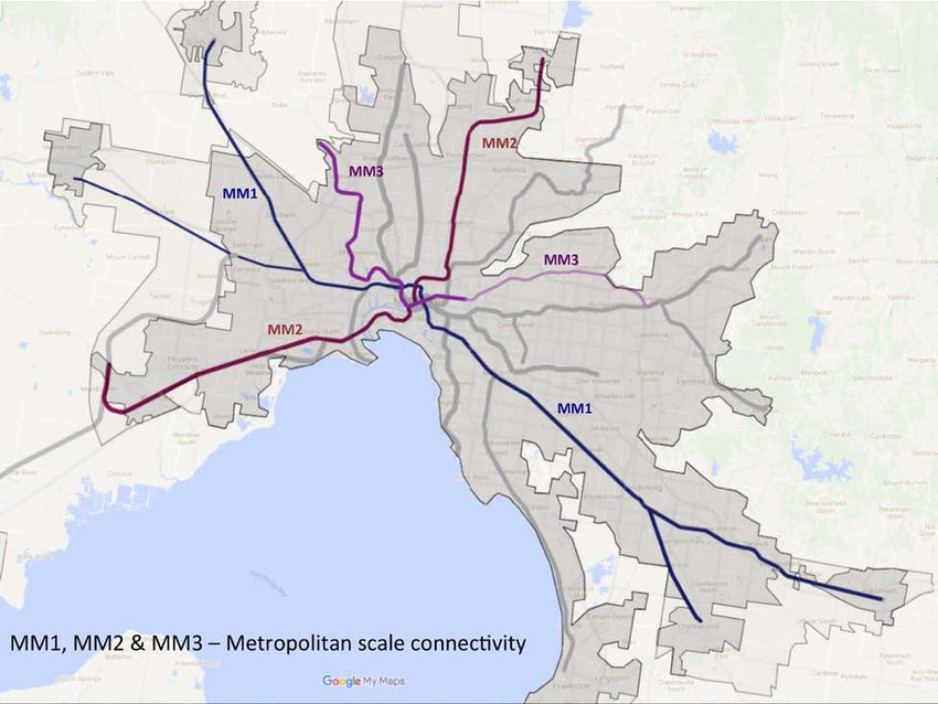
2. CURRENT PERFORMANCE
2.1.        Mode share
Melbourne’s train, tram and bus services play an important role in maintaining the economic and social
fabric of the metropolitan region. This is especially true for the City of Melbourne where nearly 70% of the
central city’s nearly 200,000 workers arrive by public transport (see Table 1).
Figure 1 shows that there is a significant drop-off (from 70% to 47%) in the mode share for public
transport for the growing number of work-trips to destinations outside the Hoddle Grid. The encouraging
aspect of this data is the growth in public transport mode share for all workers in the Melbourne Local
Government Area (LGA), with the rate of growth higher for destinations beyond the central city.

Mode Share (Journey to Work) in Melbourne LGA
                             Melbourne LGA                   Hoddle Grid          Remainder of Melbourne LGA1
                           2011         2016          2011                 2016      2011            2016
Employed persons         320,247       389,283       167,779           199,223      128,333         161,278

Employed persons (%)         -            -           52.4                 51.2       40.1           41.4

MODE SHARES (%)
Public transport total     51.2          56.4         64.9                 69.2       39.3           46.9
   Train                   39.5          44.1         50.5                 54.0       30.2           37.1
   Ferry/tram              9.5           10.1         11.7                 12.3       7.4             8.1
   Bus                     2.2           2.2           2.7                 2.8        1.7             1.7
Car total                  38.0          32.8         24.2                 20.5       49.3           41.3
   Car driver              34.3          30.0         20.7                 17.9       45.5           38.4
   Car passenger           3.7           2.8           3.6                 2.6        3.8             2.9
Bicycle                    3.6           3.7           3.3                 3.2        4.2             4.4
Walked only                5.5           5.6           5.7                 5.7        5.4             5.8
Other modes                1.7           1.5           1.6                 1.5        1.7             1.6
Table 1: Percentage mode splits for the journey to work in 2011 and 2016 (ABS Census 2016)

Footnote 1: Outside of the Hoddle Grid

There are multiple reasons for the significant differences in public transport mode share for destinations in
the Hoddle Grid (the City’s historical commercial district) compared with travel to destinations in the
remainder of the City of Melbourne. These include the relative convenience of car travel (including greater
access to parking and lower congestion), and the need for most commuters to transfer between services
at some point in their journey. These issues need to be addressed to ensure that congestion does not
worsen and to support increased commercial and residential development in locations identified in City of
Melbourne land-use plans. Solutions include increased density of the on-road public transport network,
faster tram and bus speeds relative to cars, and more convenient conditions for transfers between
services.

                                                                                                                6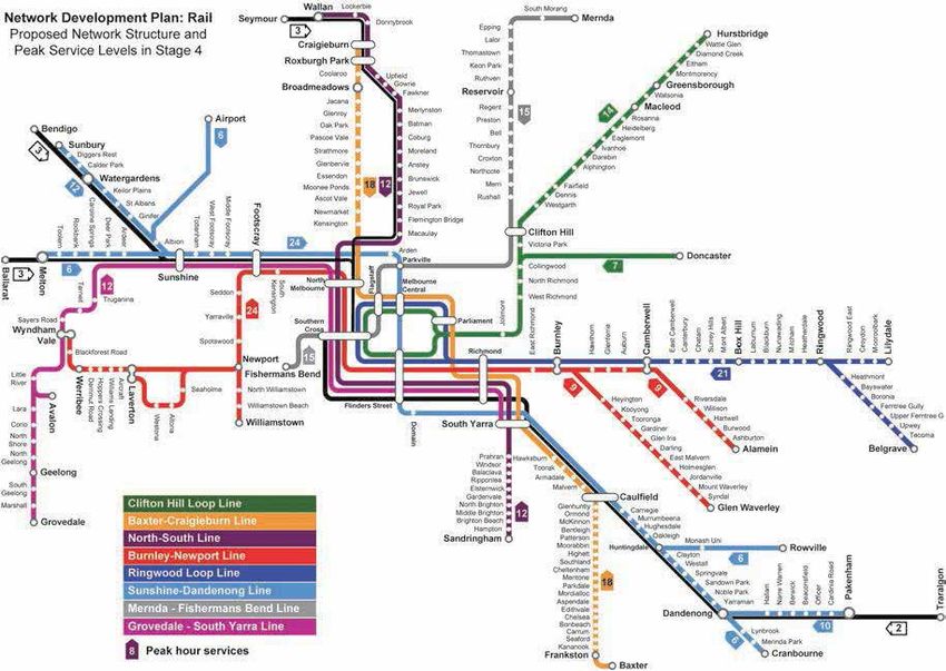
Journey to Work Mode Share
 100%

  90%

  80%

  70%
                                                                                              Other
  60%
                                                                                              Walked only
  50%
                                                                                              Bicycle
  40%                                                                                         Car
  30%                                                                                         Public transport
  20%

  10%

   0%
                      Hoddle Grid                    Remainder of Melbourne LGA

Figure 1: Journey to work mode share comparison for the Hoddle Grid and remainder of
Melbourne LGA (2016 Census)

                     Journey to Tertiary Education Mode Share - Inner
                                        Melbourne

                                          1%

                                                                                      Public transport
                              33%                    32%
                                                                                      Bicycle
                                                                                      Walking
                                                                                      Private vehicle
                                                    8%                                Other

                                       26%

Figure 2: Mode share for travel university students in Inner Melbourne (VISTA 2013)

ABS data also shows that jobs in metropolitan Melbourne remain concentrated in the Melbourne LGA.
Additional indicators of the importance of public transport for the City of Melbourne can be found in the
Victorian Government household travel surveys (VISTA). Publicly available data from 2013 shows that
students use public and active modes for over two-thirds of their weekday trips in Inner Melbourne
(Figure 2). This data also shows that trips for work and education account for less than half of all

                                                                                                             7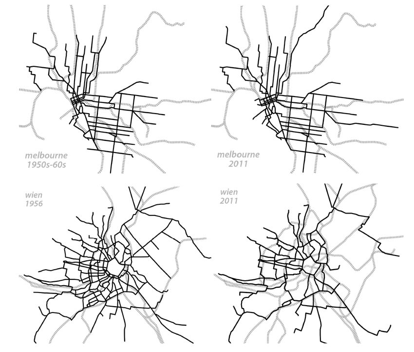
weekday travel in Inner Melbourne (Figure 3), and that private car travel is the dominant mode for these
purposes. This shows that there is a large market in social and recreational trips that public transport
could be accommodating.
More recent VISTA data held by the City of Melbourne confirms these patterns.

Figure 3: Trip purpose and mode by region in greater Melbourne (VISTA 2013)

                                                                                                           8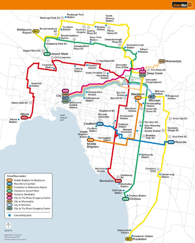
2.2.    Overcrowding
Public Transport Victoria conducts annual surveys of passenger loads. It reports these against
benchmark standards of capacity for trams and trains.
Between 2016 and 2017, these surveys on trains showed a significant reduction in the number of load
breaches. This was largely due to the removal of seats in many rail carriages to lift the benchmark load
from 798 to 900 passengers; and to the introduction of new train services. Even so, many passengers in
the north and west still travel on trains that exceed the new benchmarks, particularly in the PM peak.
Benchmarks are exceeded in the PM peak by 12 percent on the Werribee Line, 33 percent on the South
Morang Line and 36 percent on the Craigieburn Line).
The surveys of tram loadings show an increase in the number of periods during the day in which average
loads are approaching capacity. This is due to an increase in population along tram routes which has not
been matched by service improvements.
2.3.    Reliability and speed
Data on punctuality measures (reported in the PTV publication ‘Track Record’), does show some recent
improvement. However, a service is counted as ‘on time’ if it runs between one minute early and 5
minutes late and, with this relatively relaxed target, operators currently achieve monthly metropolitan
punctuality averages of 61 percent for trams and 92 percent for trains. This is below the expectations of
travellers who have a choice of car travel. The Zurich regional rail system operates with targets of 75
percent of arrivals within 2 minutes of schedule and 95 percent within 5 minutes.
Very slow speeds of tram and bus services in mixed traffic in the inner city at most times of the day are
also significant deterrent to public transport use. Recent data on tram and bus speeds does not appear to
be available. In 2006, the estimated average tram speed was 15.9 km/h (Currie 2006, Do Melbourne
                          nd
trams have a future?, 22 ARRB Conference, Canberra). Buses are similarly affected by low speeds,
although data is not publicly available. Anecdotal observations of congestion delays for buses in sections
of key corridors such as Hoddle Street suggest that typical peak period travel speeds are hardly faster
than walking pace.
These problems with reliability and speed have multiple causes from ageing infrastructure and inefficient
work practices on the train system to a vicious cycle of low mode shares for tram and bus leading to large
volumes of car traffic and therefore strong political resistance to improving on-road priority for public
transport vehicles.

                                                                                                            9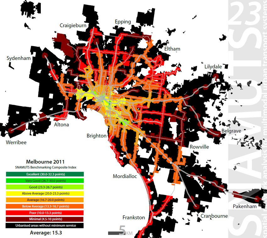
3. BETTER PUBLIC TRANSPORT FOR THE CITY OF MELBOURNE:
   KEY ISSUES IN BRIEF
Continued improvement in public transport is necessary to support increased economic and social activity
in the City of Melbourne. To achieve this, important strategic issues need to be addressed.
The key issues are:
    1. Significant growth is expected in demand for public transport for trips into and around the City
       of Melbourne.
    2. To cater for this growth, new public transport capacity is required beyond current Victorian
       Government commitments. This capacity is needed in three areas:
            •   Radial trunk rail lines
                New lines beyond Melbourne Metro Rail (Stage 1): Melbourne Metro Rail (Stage 2 –
                Clifton Hill-Newport); Airport Rail Link; and various suburban rail extensions; and
                changes to operating patterns in the central city.
            •   A denser and better connected inner-city tram and bus network
                Improved public transport access to the inner-city beyond the Hoddle Grid is vital to
                support the City of Melbourne’s land-use and development objectives.
            •   Suburban orbital lines
                Improved resilience of the existing radial public transport system centred on the City of
                Melbourne requires stronger orbital networks and intermodal connectivity.
        Many options to deliver increased capacity have been canvassed by agencies including Public
        Transport Victoria and Infrastructure Victoria, and by professional bodies and community groups.
        Our purpose in describing some of these options in this paper is to encourage informed public
        debate on priorities for delivery of new public transport projects.
    3. Demonstrating benefits, making choices: why metropolitan transport planning matters,
        Decisions on funding, timing and scope for projects to deliver increased public transport capacity
        are primarily made by the Victorian Government. A robust and transparent planning process is
        needed to capitalise on the perspectives and expertise available through the City of Melbourne
        and from the wider public.
    4. Getting value for money from Victorian Government spending on public transport and why
       this matters to the City of Melbourne.
        The ability of public transport to provide an attractive alternative to individual car travel clearly
        depends on the quality of the service. Improving the returns on Victorian Government investment
        in the quality of service provided by private operators of train, tram and bus systems is an
        important advocacy issue for the City of Melbourne.
    5. Providing sufficient space on streets and in stations for growth in pedestrian movements
       associated with increased public transport patronage in the City of Melbourne.
Each of these issues is explored in more detail below.
Note on new transport technologies: It is likely that new technologies and economies associated with
autonomous vehicles will create challenges and opportunities for transport planning in coming years.
Most international expert opinion suggests that mass public transport systems will remain vital in space-
constrained locations such as inner Melbourne.

                                                                                                            10
4. PUBLIC TRANSPORT ISSUES & OPTIONS
In this section, we provide descriptions and analysis of the key issues for improved public transport in
Melbourne and outline options for future action. This is done to support public debate as part of the
development of the City of Melbourne’s Transport Strategy.
First, we demonstrate the mismatch between expected public transport demand in the City of Melbourne
and current commitments to increased capacity, then we explore priorities for infrastructure and service
improvements for public transport:
• Priorities for radial rail expansion.
• A denser inner-city bus and tram network.
• Suburban orbital public transport.
Following this, we examine current processes for planning and funding future infrastructure requirements.
Finally, we consider the requirements for space to cater for growing numbers of pedestrians
4.1. Significant growth is expected in public transport demand
The City of Melbourne forecasts significant growth in activity between 2016 and 2036 (see Figure 5).
Predictions for daily populations in 2036 include:
• 263,000 residents (up 93 percent on 2016)
• 125,000 students (up 60 percent on 2016)
• 549,000 workers (up 43 percent on 2016)
• 197,000 metropolitan and regional visitors (up 7 percent on 2016)
• 218,000 international and interstate visitors (up 148 percent on 2016)
(www.melbourne.vic.gov.au/SiteCollectionDocuments/daily-population-estimates-and-forecasts-report-
2017.pdf)
Even allowing for the typical uncertainties surrounding demographic forecasting of this type, transport
systems for travel into and around the City of Melbourne clearly face enormous challenges in coming
decades. For the City of Melbourne to remain an attractive location for high-level commercial and social
activity, improvements to public transport will be needed.
The Victorian Government’s current metropolitan strategic plan (Plan Melbourne) includes policy
objectives to encourage growth in employment in suburban Activity Centres and National Employment
and Innovation Clusters (NEICs). However, without positive changes to the public transport system, these
ambitions are unlikely to be realised.
Instead, suburban employment opportunities will continue to centre on ‘population-based’ sectors such as
construction, education and health services. The economic power of the ‘centre’ will ensure continuing
growth in metropolitan-level commercial and social activity in the central city and in the identified
commercial and public-use zones in the City of Melbourne and in surrounding municipalities. This will be
particularly true in locations where strong public transport links exist or are created, and is the motivation
for our proposals for a strengthened inner-city network in section 4.3.2.
4.2. New public transport capacity is required beyond current Victorian Government
commitments
In this section, we look at options and priorities for providing new public transport capacity for
metropolitan Melbourne, with a focus on the needs of the City of Melbourne. Many of these options have
been canvassed by agencies including Public Transport Victoria and Infrastructure Victoria. First, we
demonstrate the gap between demand and currently committed rail expansion. Then, in turn, we consider
priorities for new radial trunk rail lines, inner-city bus and tram networks, and suburban orbital lines.
4.3. Demand will exceed new capacity from Melbourne Metro Rail Stage 1
In this section, we compare committed public transport capacity increases against Victorian Government
growth projections.
11The modelling used to support the case for the current stage of Melbourne Metro Rail (MMR1) predicts
large increases in demand for travel to the City of Melbourne. Specifically, the Victorian Government’s
transport model (VITM) forecasts a 90% increase in morning peak rail patronage into the central city from
2011 to 2031. This equates to an additional 116,000 train passengers each morning.
We have estimated the increase in daily passenger capacity that planners expect to achieve through the
works currently in construction for MMR1 and new larger trains now on order. To do this, we have used
data on planned increases in train numbers and seating capacity from the current version of the PTV’s
Rail Network Development Plan (see box below and ) and the work plans outlined in the ‘extended’
MMR1 business case.
The PTV Rail Network Development Plan (NDP) was released in 2012 (and updated in 2016) is an
unusual document for Victoria: it publicly sets out the ambitions of public transport managers (PTV now
TfV) for expansion of the system. It argues that the principal constraint in the current system is the
capacity of the City Loop and the Flinders St-Southern Cross Viaduct and presents a plan for staged
transformation of the Melbourne rail system into a ‘metro-style’ operation. This means separating the
system into pairs of cross-town radial lines with no need for shared tracks in the central core. This
improves efficiency because delays on one line will not cause problems for other services. The first
stages of this transformation will be achieved through the current Melbourne Metro Rail project (MMR1),
but the NDP argues that the full benefits will only be realised after construction of Melbourne Metro Rail 2
(MMR2) – a second metro tunnel from Clifton Hill to Fishermans Bend.
Figure 4: 2032 Metropolitan Rail Network (PTV Network Development Plan - Metropolitan Rail
2012)
12The additional daily passenger capacity will meet only around two-thirds of the growth in demand
to 2031 (see Figure 5).
The capacity to meet projected demand for rail travel to the central city will only be available following
completion of the later stages of the Rail NDP. These works include MMR2 and associated improvements
to signalling to achieve the physical and operational re-organisation of the City Loop to allow for full
‘metro-style’ operation of the suburban rail system.
Figure 5: Current capacity improvements will not meet project growth in demand
4.3.1. Priorities for radial rail expansion
With future demand for rail travel to central Melbourne far outstripping the capacity to be delivered
through currently committed projects, it is important that the City of Melbourne identify its priorities for new
heavy rail projects and to advocate for these. This paper aims to assist the City of Melbourne in this task
by summarising the key project options for radial rail expansion.
Infrastructure Victoria, in its Draft Infrastructure Strategy, has identified many new rail projects that might
be pursued. The Victorian Government has currently given no clear, public indication of its priorities.
In this section, we examine the options and benefits for the City of Melbourne of some of the key projects
identified by IV, these include:
• Melbourne Metro Rail (Stage 2).
• Airport Rail.
• High Speed Rail.
• Other suburban rail extensions
We consider that Melbourne Metro 2 and Airport Rail are the two priorities for the City of
Melbourne.
134.3.1.1. Melbourne Metro Rail 2
A version of Melbourne Metro Rail (Stage 2) (MMR2) is contained in the 2012 Network Development Plan
(see Figure 4). This proposal involved routing the Mernda line in a new tunnel under the central city from
Clifton Hill to Fishermans Bend. Infrastructure Victoria’s Draft Infrastructure Strategy described the project
with its logical extension: a connection between the Werribee and Mernda lines via a tunnel from Clifton
Hill to Newport (see bottom map in Figure 6 and further quote from IV in the box below). We consider this
to be the major public transport infrastructure priority for the City of Melbourne. It can and should be
constructed to be operational before 2030.
Figure 6: MELBOURNE METRO RAIL 1 and 2 alignments: TOP: MMR1 (Dark Blue, under construction)
BOTTOM - Proposed MMR2 (Maroon) – Preferred alignment. With existing tram network (light green)
14… the transport modelling found that in providing direct rail connections across the city, this project would
enable passengers to more easily travel between destinations on the rail network and reducing travel
times. It would improve access to the CBD for both public transport and car travel, the percentage of
population within 45 minutes of the CBD increasing by between 2 and 3 per cent. It would also improve
access to a number of NEICs, most notably East Werribee (6 percent increase) and Latrobe (3 percent
increase), which are located at either end of Melbourne Metro Rail 2. It would provide significant
congestion relief to the Werribee and South Morang Lines.
MMR2 assessment, Infrastructure Victoria 2016, Draft Options Book, p.490
The preferred alignment and station locations for MMR2 have not been determined in these plans.
The current Draft Fishermans Bend Framework contains two possible alignments between Southern
Cross Station and Fishermans Bend (Figure 7).
Figure 7: Fishermans Bend Draft Framework – Possible MM2 Stations
The northern route is preferable because it directly serves the NEIC precinct within Fishermans Bend.
This alignment would best drive the transition of Fishermans Bend’s from an industrial zone to an
extension of Melbourne’s central city, with a less car-dependent built form. Early provision of metro
services would encourage more active and sustainable travel behaviour than if the line were delivered
after the area had been substantially re-developed. Without a rail line, Fishermans Bend would be
developed with high levels of structured parking provision, making dwellings and offices more expensive
and taller than necessary.
Between Clifton Hill and Newport, we recommend that additional stations are added to the MMR2 project.
We propose locating stations in Fishermans Bend (serving the NEIC and Sandridge precinct as a
minimum, and ideally also in the Convention Centre/Yarra’s Edge precinct to allow better active transport
access to a major attractor), Southern Cross, Flagstaff/Victoria Market, Parkville/Haymarket, and Fitzroy
before connecting with existing lines at Clifton Hill (see Figure 8). The stations at Fitzroy and Clifton Hill
will add much-needed network connectivity with surface public transport in the inner north, as well as
15east-west accessibility. These proposed interchanges are opportunities to extend the local catchment of
the rail network.
New metro stations can expand local accessibility sufficiently for them require to new names. For
example, the new CBD South station will be called Town Hall, because it extends access to the rail
system into the Town Hall precinct, as well as providing additional ways to enter Flinders Street Station.
Figure 8: Melbourne Metro Rail 2 (MMR2) – proposed stations
In the same way that MMR1 improves accessibility to commercial zones in the City of Melbourne from the
north-west and south-east of the metropolitan area, MMR2 would provide dramatically improved access
from the south-west and north-east.
Improving public transport accessibility from the west is a priority for equity reasons. Population growth in
Melbourne’s west is the highest in Victoria. The region’s demographics have shifted to now include a
higher proportion of white-collar professionals whose employment and educational aspirations are
currently best met in the central and inner city. Long-term land-use change to encourage knowledge
economy employment and educational institutions to locate in the west is needed, but in the medium
term, better public transport access to the City of Melbourne from the west is necessary.
We estimate that MMR2, with the use of longer trains and metro-style frequencies, would quadruple
passenger capacity for the Werribee line corridor. Combined with much-needed frequency and on-road
priority improvements for feeder bus services, this will enable modal shift in Point Cook and other parts of
the west where rail access is currently poor and car dependence is high.
MMR2, if configured with a separate set of platforms at Newport and separate tracks connecting it to the
Werribee line, will also free up capacity on other lines in the inner west, allowing higher service
frequencies on the Altona and Williamstown Lines.
16Another major benefit of MMR2 is the greatly improved east-west accessibility it provides in the inner
north: connections between Parkville, Carlton, Fitzroy and Clifton Hill are very poor at present, and hard
to improve due to limited road space.
Based on the timelines required for planning and approvals, tunnel construction and commissioning, and
the timelines for completion of major stages of MMR1, we are advised by technical experts that, if the
Victorian Government were to commit to MMR2 in 2018, the new line could be operational by 2028 or
earlier. This is because MMR2 is not dependent on MMR1 being operational, and builds on work already
done to design the MMR1 station at Parkville for the eventual arrival of MMR2.
MMR2 is a strategic alternative to major road projects, including the Westgate Tunnel and the North East
Link, which are less sustainable and more expensive ways to cater for increased demand for travel to the
central city, as well as from east to west. Notably, MMR2 also provides a new strategic high capacity
crossing of the Yarra River from the west.
4.3.1.2. Melbourne Airport Rail
The original intention of Melbourne Metro Rail 1 was to provide capacity in the central core of the radial
rail system to allow for a branch line to Melbourne (Tullamarine) Airport via Sunshine and the Albion
freight corridor. Growth in demand for passenger services to Melton and Sunbury means that this
capacity will not be available for Melbourne Airport trains when the tunnel opens.
Figure 9: Concentrations of suburban jobs (i.e. excluding the inner and central city), showing the
importance of the airport precinct. SOURCE: The Melbourne Urbanist c/- Crikey
17The Victorian Government announced in November 2017 a new planning process to identify how capacity
between Southern Cross and Sunshine can be increased to allow the Albion route to be used for an
Airport Link as part of a high-speed regional network. This is expected to involve new tunnels.
There are other options for a viable public transport service to the airport, but in order to discuss these,
we need to be clear about the markets that a Melbourne Airport rail line needs to serve.
International experience shows that airport rail works best if it is designed to serve a number of markets,
such as airport employees and people wishing to travel along the corridor, rather than simply carrying
businesspeople and tourists to and from the central city.
While air travellers will make up most of the transport demand, Melbourne Airport is a significant
employment centre, on a par with many of the higher order activity centres in the west or anywhere in
suburban Melbourne already served by heavy rail (Figure 9). A rail link to Melbourne Airport will need to
service a range of users and employment clusters to be viable. It will need to be planned and delivered as
a key node in a multi-modal public transport network.
The State Government has indicated that it favours the express service from Southern Cross, forming
part of an eventual higher-speed regional network. There are several options for the route for this service,
but the Sunshine route (shown in purple in Figure 10) appears to be preferred by state agencies because
of the very rapid journey time to the airport from Southern Cross, the availability of railway land north of
Sunshine, and the potential to remove regional trains from the suburban network. However, its chief
disadvantages are poor connections to the suburban network (which means it will not be attractive to any
traveller who cannot easily get to Southern Cross or Sunshine), and the high costs of tunnelling required
between Southern Cross and Sunshine.
Other options for new services exist and should be explored and compared with the Sunshine route on
cost and quality of service.
These include:
• An express monorail from Southern Cross to the airport (especially if it includes intermediate
stations at Bell Street, Essendon Airport and the Western Ring Road to connect with high-quality
bus routes – shown in yellow, Figure 10).
• A metro through many of the larger urban renewal and employment precincts in the north-west
sector between the CBD and the airport (such as E-Gate, Arden-Macaulay, Showgrounds, VU
Footscray, Highpoint, Maribyrnong Defence Site, Niddrie, Essendon Fields, Airport West and
Tullamarine) (two possibilities shown in Green and Red Figure 10, preferred option in Figure 11).
Figure 10: Comparison of possible Melbourne airport rail alignments. L-R: Purple High-Speed
Regional rail; Green – metro line from Showgrounds branch; Red – North West Metro (MM3?);
Yellow – Monorail along Tullamarine Fwy; Orange – branch from Craigieburn Line
18Figure 11: Melbourne Metro 3? – a northwest metro (purple) connecting the airport to the CBD via
several of Melbourne’s key urban renewal areas could provide a 25-minute airport trip from
Southern Cross (the Light Purple line illustrates a logical extension of this metro to Ringwood via
Doncaster).
Figure 11 shows a possible preferred route for a ‘metro style’ service to the airport – a Melbourne Metro 3’
that would extend the market for rail access to the airport by connecting current and growing activity
centres and major urban renewal areas in the north-west region between the central city and the airport.
Crucially, it would include an interchange with Arden (soon to be renamed North Melbourne) Station on
Melbourne Metro Rail 1, and potentially North Melbourne Station (soon to become West Melbourne).
The proposal for ‘MM3’ has been investigated as a high-frequency driverless new generation medium
capacity rail service. These have been successfully operating for many years in Europe and more
recently Asia. Smaller sized vehicles require lower impact infrastructure and tunnels and stations are
therefore less expensive to construct than for standard or the next high capacity Melbourne passenger
trains. The benefits of extending the ‘MM3’ to Ringwood via Doncaster and Kew are:
• fills a major gap in the radial passenger rail system in the eastern suburbs
• provides better walk-up access, network connectivity and land use integration benefits than the
proposed Doncaster Rail route via the Eastern Fwy (which would be reliant on improving feeder
routes to transfer points in the freeway)
• creates network effects of benefit to the outer east by connecting to the interchange at Ringwood
with two other heavy rail lines (Lilydale, Belgrave) and the proposed orbital Metro Light Rail from
Ringwood to Dandenong via Knox and Rowville (see section 4.3.3 on orbital suburban routes)
• extends the catchment of the MM3 airport metro line to the eastern suburbs
19However, the debate about airport rail should not be reduced to a question of a single route for a railway.
There are many other access options that should also be examined and where possible, implemented.
Options to improve airport access by suburban public transport include (See Figure 12):
• extending the 59 tram by 7km from Airport West to the airport
• adding new bus routes and increasing the frequencies of the PTV bus services already serving
the airport.
• building a station at Campbellfield on the Upfield Railway line and adding a bus along Camp
Road to the airport.
• providing a light rail or frequent bus service between the airport and Greensborough via La Trobe
University, with connections to rail lines serving the north and north east.
• Providing light rail or frequent bus services between the airport and various destinations in the
west (eg. Caroline Springs, Sydenham/Watergardens, St Albans, Deer Park, Laverton, Point
Cook). Deer Park is a priority as it is a major interchange for suburban and regional rail lines.
Figure 12: Options to improve public transport access to Melbourne Airport: TOP – Current airport
access by suburban public transport (Orange = PTV Bus); BOTTOM – possible extended and
additional public transport to improve access to the airport (Orange = PTV Bus; Dark Green =
Tram extension/upgrades; Light Green = New Smart Bus routes; interchanges with rail or tram
marked with red balloons).
Demand for access to the airport by passengers and workers is already large and is predicted to grow to
levels comparable to current arrivals at Heathrow Airport in London. Comparison with Heathrow is
enlightening. Commuter rail access was first provided in 1977 by an extension of the ‘Tube’, with an
express line added in 1998. In 1986, Heathrow was serving 31.7M passengers - the same number of
20Melbourne is projected to serve in 2020. By 2028, Melbourne will have similar landside access needs
(55.2M) as Heathrow had in 2017 (57.7m). Heathrow currently has 3 rail services, 13 public bus lines and
27 coach services. 40% of passengers access Heathrow via public transport (27% rail, 13% bus / coach).
35% of Airport staff access Heathrow by public transport, and this is rising. Melbourne Airport has various
private buses and shuttles and 4 public buses and regional coach services, which together have a mode
share of about 14%, the remainder being via private cars and taxis (Booz 2014: 15). All access is via
road-based modes, and the capacity constraints of the Tullamarine Freeway have become all too clear.
Trips to the airport have origins across metropolitan Melbourne. If public transport is to properly serve
these markets, the airport will need to be firmly linked into the suburban public transport network through
multiple modes and good connections between them. Moreover, if the airport is to remain viable,
alternative means of providing reliable access for increasing numbers of employees and passengers
requires quantum leap in public transport provision
In short, the City of Melbourne should advocate for detailed analysis of all routes that receive a positive
assessment from Infrastructure Victoria and any route with an evidence-based strategic rationale.
4.3.1.3. High-speed rail (HSR)
The City of Melbourne, in its 2012 Transport Strategy, expressed general support for the concept of the
East Coast HSR.
The important issue for current advocacy work by the City of Melbourne is the consideration of alignments
for HSR inside the boundaries of greater Melbourne.
In this regard, we support the directions of the Rail Futures Institute (RFI 2016) InterCity paper, released
at the end of 2016. This document proposes a long-term upgrade of Victoria’s regional rail network to
become a series of high-speed lines to connect Melbourne with Victoria’s larger regional cities. The key
node for this proposed network in Melbourne north-west is Melbourne Airport, which, as described above,
would be linked to the central city by an express rail link. This alignment could also be used by interstate
HSR along the east coast.
4.3.1.4. Other suburban rail expansion
There has been long debate about the need to expand Melbourne’s radial rail system to keep pace with
outer suburban expansion in the growth corridors and to fill in coverage gaps in the east (Doncaster) and
south-east (Monash NEIC/Rowville). There are many other proposals in the PTV Network Development
Plan from 2012 (see Figure 4), extending the Upfield Line to Wallan being especially urgent.
These are necessary components of a system that can relieve the problems of suburban car-dependence
and should be pursued at all costs as an alternative to suburban freeways.
There is little detail available publicly from which to assess the specific value of proposals such as the
Doncaster BRT that is suggested as an adjunct to the North East Link. However, any attempt to seriously
compete with car travel in this corridor must offer much faster travel times than the current bus services.
This means that there must be an alternative to leaving passengers stuck in congested traffic west of
Hoddle Street. Ongoing improvements to Doncaster and other suburban buses that offer a demonstrable
improvement to public transport’s competitiveness with the car can be used to prove patronage demand
for heavy or light rail along these corridors in future, but only if reservations are not lost to road-widening
in the short term.
4.3.2. A denser and better connected inner-city tram and bus network
Continued improvement in public transport mode shares for key locations outside the Hoddle Grid where
land-use intensification is planned is necessary to avoid congestion and minimise the space requirements
of the transport system. This will require increased capacity (largely achieved through improved vehicle
speeds and on-road priority) for tram and bus movements into and around the City of Melbourne.
The Victorian Government has no public plans for improvements to inner-city bus and tram networks,
although we understand that work of this nature has been undertaken by Transport for Victoria and Public
Transport Victoria.
21A key aim for City of Melbourne advocacy should be to encourage the public release of these plans as
means to engage with interest groups and the wider public, and to support the Victorian Government and
private operators in establishing a staged program of works.
The comparison of the benefits in accessibility and system resilience for specific scenarios for new
services is beyond the scope of this paper, but Section 4.4 proposes the use of the SNAMUTS model in a
public process to explore the relative merits of different proposals.
In this context, it is useful to refer to the aspects of the experience of network development in two
exemplar cities, Vienna and Zurich.
Greater Vienna, with its population of 2.6 million, is one of the world’s most ‘transit-connected’ cities (see
comparison with Melbourne in Figures Figure 13 and Figure 14).
Use of motorised modes has fallen continuously since the early 1990s, and residents of cheaper housing
in suburban locations have cost-effective access to jobs, education and other benefits of city life.
Figure 13: Greater Vienna, SNAMUTS accessibility analysis
22Figure 14: Greater Melbourne, SNAMUTS accessibility analysis
Wiener Linien – the city’s public transport operator – uses the slogan Die Stadt gehört Dir (the city
belongs to you). The sale of 1 million yearly transit passes for a subsidised price of €365 (A$590) within
12 months shows the truth of this slogan.
Planning to achieve this high-level of performance is based on a standard for public transport supply quite
different to that used in greater Melbourne. Here, the standard for public transport supply is that every
house should be within 400m of a public transport stop, regardless of the quality of the service. In Vienna,
a location is considered by planners to be adequately served only if it is possible to reach a rapid transit
line within 15-minutes travel-time at most times during the day and at weekends. This goal is supported
by most politicians and by planners of land-use and transport, so budgets and works programs are
directed towards its achievement in coherent manner over many years.
For Melbourne, an interesting comparison with Vienna is their creation of a dense network since the
1950s, contrasted with the stagnation of public transport in Melbourne (Figure 15). As the metro system
of ‘medium-capacity’ rail has been expanded, the tram (and bus) routes of the inner-city have been re-
purposed as an effective distributor and connector system, creating a dense and highly-accessible
network. These routes concentrate high-frequency bus and tram services on key corridors, feeding the
23heavy rail system. The benefits of a ‘medium capacity’ model for network expansion in Melbourne are
described here (Knol and Stone 2015).
Figure 15: Comparison of Melbourne and Vienna: fixed route public transport networks
Outline of Melbourne’s fixed-route public transport network (trams in black, suburban rail in grey) in the
1960s and in 2011
Outline of Vienna’s fixed-route public transport network (trams in black, metro and suburban rail in grey)
in 1956 and 2011
Zurich has also re-modelled its suburban and regional rail and inner-city tram and bus network to support
a dramatically upgraded radially-oriented suburban/regional rail system. The Swiss planning model that
underpinned its cost-effective creation of conditions for high-performance regional and suburban rail
development is described here (Stone 2013).
Of particular interest to the City of Melbourne is Zurich’s experience in transforming its historic street-car
system to one of the world’s most efficient light- rail networks. The catalyst for this change was a
referendum in 1973 that rejected a city council proposal to put the trams underground on the
contemporary model of the German U-Bahn (subway). Instead, citizens voted to direct transport planners
to not only keep the trams but also to ensure that they could travel ‘as fast as was technically possible’.
24After some internal debate, the city’s transport planners changed direction and. over the next decade,
largely achieved this objective. On some central city lines, trams travel at the same speeds during peak
as they do at midnight. This feat was achieved through a combination of gradual removal of on-street
parking on tram routes (a political decision that is still honoured as the ‘historic compromise’; and a
unique system of traffic signals which allow only a small number of cars onto tram streets at any one time
and which give absolute priority to trams at intersections. (For details see Cervero, 1998, The Transit
Metropolis, Island Press.)
254.3.3. Suburban orbital routes
4.3.3.1. Why suburban orbital public transport lines matter to the City of Melbourne
Melbourne’s high-capacity public transport comprises rail and tram lines that converge on the central city
in ‘radial’ spokes (see Figure 16)
Figure 16: Melbourne’s trains and trams radiate from the central city area like ‘spokes’
It is immediately obvious to most potential users of the system that most cross-town or suburb-to-suburb
(‘orbital’) trips will be long and inconvenient. In addition, such a system will require increasingly expensive
capacity upgrades on its key radial routes and is vulnerable to disturbances because there are no
alternative paths that might be used to bypass congestion or delay at the centre.
In an analysis of possible alternatives to this inefficient and vulnerable pattern of service delivery, Curtis
and Scheurer (2016 p. 9) note that the radial model will:
minimise public transport usage for journeys between suburban nodes that are not on the same
line, and … simultaneously convey a sense of capacity crisis for … journeys to and from the
CBD. Cities often address this conundrum by adding ever more services to the radial lines …
while failing to investigate and realise the accessibility benefits and added resilience that may be
associated with a greater dispersion of network paths away from established public transport
trunk lines.
Further, it “leaves the grid-shaped (suburban) arterial road system unutilised by public transport routes”,
despite the large number of journey paths (i.e. potential public transport patrons) using these routes.
The role that orbital public transport can play in Melbourne was demonstrated by the 901, 902 and 903
orbital SmartBus services (Figure 17). Introduced between 2005 and 2010, these routes have become
some of the busiest in Melbourne. By linking centres of activity such as shopping centres and high streets
with radial tram and train lines, the orbital SmartBus system complement radial rail lines, as well as
increasing demand for the latter by enlarging the accessible catchments for public transport overall.
We recommend that the City of Melbourne advocate for new approaches to network design to support the
creation of effective and efficient suburban orbital lines that build on the patronage growth already
achieved through the SmartBus program, with high-quality interchanges that connect to radial public
transport services.
26Figure 17: Melbourne’s orbital and radial SmartBus routes
4.3.3.2. Trams and Suburban Light-Rail Transit (LRT)
Infrastructure Victoria has recommended trams as a city-shaping tool as much as mode of transport,
because of its association with land value uplift and suburban intensification. Tram lines promote
residential development and mixed land uses such as commercial office space and retail. Recent analysis
27has suggested that there is a strong connection between tram corridors and locations for increased
residential and commercial development in Melbourne (Scheurer and Woodcock 2017). As a result, tram
services along these corridors are becoming increasingly crowded as they struggle to keep up with
demand. Given the scale of Melbourne’s tram network, this considerable challenge will take many years
to solve. Until these changes are made, the problems of slow speeds and poor punctuality will not be
overcome.
Transport advocacy groups have proposed improvements to Melbourne’s tram system. Broadly, these
can be categorised into upgrades to achieve on-road priority and incremental extensions to the existing
tram network, and far more ambitious proposals for a new network of suburban light rail (LRT)
alternatively referred to as ‘Metro Light Rail’ (MLR).
The distinction between trams and LRT is important. Melbourne’s existing tram network is a legacy
streetcar system, with 80% of its routes running in mixed traffic with other road vehicles, often in streets
with insufficient width to easily provide separation. This leads to slow speeds (and therefore inefficient
use of expensive vehicles) and poor reliability.
Incremental improvements to the streetcar system are ongoing with the provision of universal access
stops, allocation of dedicated tram space on roads, traffic signal priority, and tram fleet renewal. The ideal
target for these processes would be a system of high-capacity and accessible trams completely physically
separated from other vehicles. A key benefit would be reduced delay, that would allow more services to
be run with the same number of vehicles. That is, more services could be run without the cost of buying
new trams or purchasing land and constructing more tram depots.
Light rail, by contrast, is an urban rail-based system designed from the outset to run in segregated rights
of way with accessible platform stops (at far greater spacing than tram stops) and high capacity vehicles.
This guarantees higher performance than can be achieved with streetcars. Light rail has many of the
speed and capacity advantages of heavy rail, but is easier to retrofit into established urban environments
and requires lighter infrastructure.
Figure 18: Gold Coast Light Rail (SOURCE: https://plenarygroup.com/news-and-media/news/2016/full-steam-
ahead-for-stage-2-of-the-gold-coast-light-rail)
The best examples of LRT in Australian cities are the Gold Coast and Sydney light rail lines (Figures 18
and 19). These services have demonstrated good patronage accompanied by land value uplift and
intensification along their corridors. LRT, because of its higher capacity, can afford to utilise a mixture of
ground level, tunnelled and elevated alignments that would be too expensive to justify for more inefficient
street car-style trams.
28Figure 19: Sydney Light Rail (SOURCE: https://ausbim.com/projects/sydney-light-rail)
There is great potential to retrofit LRT into Melbourne’s suburbs, due to the well-established grid of wide
arterial roads. The great benefit of LRT in the Melbourne context is the ability to avoid expensive
tunnelling and land acquisition by using existing corridors.
For the City of Melbourne, this is needed to extend high-quality surface public transport to emerging
zones of high land-use intensity beyond the Hoddle Grid (Figure and 21). To improve the resilience of
the entire system, it is also important for the City of Melbourne that orbital LRT is extended to the middle
suburbs.
Figure 20: Inner and central city view of proposed new LRT network, showing new orbital routes
(Dark Green, Light Blue, Dark Blue; Maroon is MMR2. Note: Dark Blue LRT would run in a tunnel
from Punt Rd and re-emerge near the corner of Anderson St and Domain Rd).
29Figure 21: Suburban Light Rail – priority corridors
Many of these LRT routes shown in Figure 21 would provide much-needed orbital and inter-suburban
connectivity between the lines of the radial heavy rail system. Some of the proposed routes provide rail
access to areas such as Doncaster and Rowville, which have long been proposed as extensions to the
heavy rail system. Compared to radial extensions to existing rail lines, LRT enables the creation of a true
high-capacity public transport network by connecting areas to multiple rail lines. The need for these kinds
of services has been demonstrated by the patronage on the orbital Smart Bus routes, which is
significantly higher than almost all suburban bus routes. These LRT corridors could initially be served by
improved bus services to demonstrate viability and passenger demand.
A case study of comparable development of LRT in suburban Toronto is described in a paper presented
at SOAC 2017 and will be published in early 2018.
If planning for a city of 8 million people by in just over a generation is the aim, then serious work must be
done to rethink how the majority of Melburnians are to be given adequate transport choices.
4.4. Why metropolitan transport planning matters: the need for an integrated
transport plan
The previous sections make it clear that very many improvements are needed to ensure that the public
transport system of greater Melbourne continues to serve the needs of residents and visitors to the City of
Melbourne.
Making decisions on competing priorities between road and rail, and on budgets, timelines and detailed
designs is a responsibility of the Victorian Government under the Transport Integration Act. International
experience shows clearly that such planning processes are most effective when they are open and
transparent and engage effectively with interest groups and the wider public.
For this reason, it is important that the City of Melbourne works closely with Victorian Government
agencies to strengthen processes for metropolitan transport planning in greater Melbourne.
We have noted the lists of project proposals put forward by Infrastructure Victoria, the PTV and interest
groups such as the Rail Futures Institute. There are many others, which take ideas from various Victorian
Government proposals over the years and embellish them. These ideas should be examined and collated
for what they have in common and assessed for their merit. A common theme, apart from extending and
adding radial lines is adding orbital (i.e. cross-town or inter-suburban) lines to connect suburban activity
30centres and ensure that all NEICs are accessible by heavy rail or LRT. These additions would have the
effect of reconfiguring the current rail-based system into a network, with a variety of ways to get between
destinations.
Decisions about major transport investment are inevitably political, and there is a clear need for new ways
to consider the relative merits of competing proposals.
Curtis and Scheurer’s SNAMUTS accessibility modelling tool (www.snamuts.com/ ) provides a useful way
to understand this point. Examples have been included in this paper (Figures Figure 13 and Figure 14).
The Spatial Network Analysis for Multimodal Urban Transport Systems (SNAMUTS) model is described
by its creators as: “an interactive decision tool designed to assist in examining the performance of a city
region’s current public transport network framed around the accessibility of the transport network and
accessibility of place”.
We are encouraged by the use that the City of Melbourne has already made of the SNAMUTS
accessibility model as a tool to illustrate and compare the benefits of different scenarios for multi-modal
public transport network development in inner Melbourne and across the metropolitan region. The strong
visualisations available through use of this tool offer a useful way to bring a new level of public and
practitioner engagement in consultative processes. For this reason, the proposals outlined in this paper
have been developed with the option of SNAMUTS testing in mind.
4.5. Getting value for money from Victorian Government spending on public
transport
We have noted earlier that, in addition to the need for new capacity, the reliability of existing services is a
major barrier to increasing the use of the public transport system as means to meet the City of
Melbourne’s economic, social and environmental objectives. Current City of Melbourne policies support
increased public transport use by residents and visitors through the improvement of reliability and system
performance.
The Victorian Government is to be congratulated for investing considerable resources to address long-
standing problems of maintenance and capital-renewal across the train and tram systems. The historical
shortfall has been well documented by PTV and operators. However, repeated institutional re-structuring
has slowed down efforts to build the institutional capacity and skills base necessary to manage growth on
the required scale, and to maintain pressure on operators to improve system performance.
The adoption of new performance targets and benchmarks can take time due to the nature of the
franchise agreements with the train and tram operators. (More detail is available here. Stone et al 2017)
As was the case with the recent changes to eliminate Metro’s practice of ‘skipping stops’ to meet
punctuality targets, public pressure is an important mechanism for change. Therefore, this issue is an
appropriate topic for advocacy by the City of Melbourne.
New benchmarks will provide valuable impetus for the implementation of effective solutions.
These new performance measures could include:
• Targets for improved reliability and efficiency achieved through the maintenance expenditure and
capital renewal investments that are included in the newly re-negotiated tram and train
franchises.
One example is a reduction in the daily number of rail signal failures. Currently, there are more
than five failures per day (Currie, slide 18).
• Targets for improvements in the reliable arrival of trains to designated platforms. This is an
important element of a positive user experience. Data from Metro (Figure 16) shows the current
extent of this problem (technically known as ‘transposal’).
31You can also read