NUI Galway Nun's Island Masterplan - Planning and Environmental Scoping Study
←
→
Page content transcription
If your browser does not render page correctly, please read the page content below
NUI Galway Nun’s Island Masterplan

Planning and Environmental Scoping Study

                                           1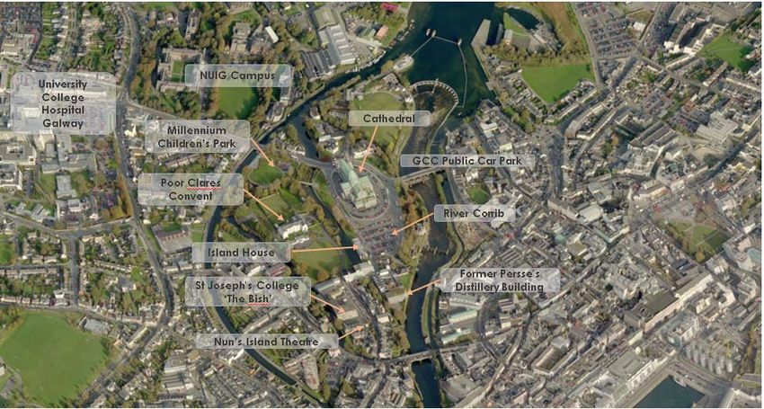
DOCUMENT DETAILS

Client:                          National University of Ireland, Galway

Project title:                   Planning & Environmental Scoping Study

Project Number:                  170503

Document Title:                  Planning & Environmental Scoping Study

Doc. File Name:                  Planning Report F1 – 2019.03.08 - 170503

Prepared By:                     McCarthy Keville O’Sullivan Ltd.
                                 Planning & Environmental Consultants
                                 Block 1, G.F.S.C.
                                 Moneenageisha Road, Galway

Document Issue:
Rev   Status        Issue Date     Document File Name          Author(s)   Approved By:

      Internal                     Planning Report D1 –
D1                  2017.05.29                                 PH          GMcC
      Draft                        2017.06.13 - 170503
      Final Draft
                                   Planning Report F-
F     for Client    2017.06.20                                 PH          GMcC
                                   2017.06.20 – 170503
      Review

      Final
      Draft-
                                   Planning Report F-
F1    Edited Red    2019.03.08                                 EOB
                                   2019.03.08 – 170503
      Line
      Boundary

                                                                               2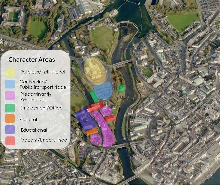
Table of Contents
1      Introduction ............................................................................................ 1
    1.1        Project Brief ..............................................................................................................1
    1.2        Structure of the report..............................................................................................2
2      Masterplan Area Description ................................................................. 3
    2.1        Defined Study Area ...................................................................................................3
    2.2        Historical Development of the Study Area ................................................................4
    2.3        Description of the Character of the Study Area ........................................................5
    2.4        Transport and Traffic ................................................................................................9
3      Environmental and Built Heritage Constraints .................................... 10
    3.1        Built Heritage Constraints ......................................................................................10
    3.2        Archaeological Constraints ....................................................................................12
    3.3        Environmental Designations...................................................................................15
4      Strengths and Challenges of the Study Area ........................................ 17
5      Consultation ......................................................................................... 18
6      Planning Policy Context ....................................................................... 19
    6.1     National and Regional Planning Policy Framework ...............................................19
       6.1.1 National Spatial Strategy 2002-2020 .................................................................... 19
       6.1.2 Draft National Planning Framework- Ireland 2040 Our Plan .............................. 19
       6.1.3 Planning Policy Statement 2015 ........................................................................... 20
       6.1.4 Regional Planning Guidelines for the West 2010 – 2022 ...................................... 20
       6.1.5 Guidelines for Planning Authorities on Sustainable Residential Development in
              Urban Areas .......................................................................................................... 20
       6.1.6 Sustainable Urban Housing: Design Standards for New Apartments Guidelines
              for Planning Authorities ........................................................................................ 20
       6.1.7 Design Manual for Urban Roads and Streets ....................................................... 21
    6.2     Galway City Development Plan 2017-2023 .............................................................22
       6.2.1 Zoning Designations .............................................................................................. 22
       6.2.2 Development Management Standards ................................................................. 26
    6.3     Galway Transportation Strategy .............................................................................27
    6.4     Other Policy Considerations ...................................................................................27
       6.4.1 Living Cities Initiative ............................................................................................ 27
7      Planning History ................................................................................... 28
8      Key Planning Matters to be Considered ............................................... 29
9      Conclusion ............................................................................................ 31

Appendices

Appendix 1             A map of NUI Galway owned buildings within the study area

Appendix 2             Photographic Survey of Study Area

Appendix 3             Planning History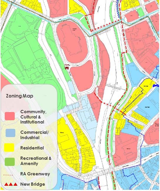
Planning & Environmental Scoping Study
                                                                      Planning Report F1 – 2019.03.08 - 170503

1       INTRODUCTION

        The Nun’s Island area of Galway City has been identified in the adopted Galway City
        Development Plan 2017-2023 as a potential regeneration area within Galway city
        centre1. Furthermore, the National University of Ireland Galway’s Vision 2020 NUI
        Galway Strategic Plan 2015-2020’2 set out a bold vision for the University campus,
        which aims to foster a vibrant community by building on mutually-beneficial
        partnerships. As a significant landowner in Nun’s Island, National University of
        Ireland, Galway (NUI Galway) is spearheading the preparation of a comprehensive
        masterplan for the area, with a view to working in partnership with Galway City Council
        to create a strategic spatial vision for a destination space within Galway City. It is
        proposed to develop a cohesive, integrated regeneration proposal for the Nun’s Island
        area, to optimise the potential of this underutilised city centre space and bring a wider
        scale benefit to the city. (A map of NUI Galway owned buildings within the study area is
        provided in Appendix 1).

        It is hoped that the regeneration of the area will cultivate sustainable development,
        encourage employment and promote continued innovation and learning. NUI Galway
        and Galway City Council realise that implementing this ambition will require a
        collaborative approach, based on detailed engagement and long-term strategic
        planning. There are a significant number of stakeholders with an interest in the
        proposed masterplan area. Neighbours and residents of Nun’s Island will need to be
        provided with an opportunity to inform and shape the strategic vision for the area and
        be kept informed as the masterplan unfolds.

        A number of national government policy and legislative changes have recently been
        adopted to promote urban regeneration in the form of the Urban Regeneration and
        Housing Act 20153 and the Construction 20204 and Rebuilding Ireland5 policy
        documents. The proposed masterplan presents an unprecedented opportunity to
        develop an ambitious, cohesive vision for the subject lands which optimise the potential
        of this underutilised city centre space and bring a wider scale benefit to the city. As a
        preliminary step in the masterplan development process, NUI Galway have
        commissioned this Planning and Environmental Scoping Study to inform the
        development aspirations for the subject lands in Nun’s Island.

        The purpose of this Scoping Study is detailed in Section 1.1 below.

1.1     Project Brief
        The scope of this Planning and Environmental Scoping Study, in accordance with the
        agreed brief, is summarised below:

1 Galway City Development Plan 2017-2023, Section 5.3 and Policy 5.1 Enterprise.
Available at: http://www.galwaycity.ie/development-plan-2017-2023/
2 Available at: https://www.nuigalway.ie/media/nuigalwayie/content/files/aboutus/Vision2020-NUI-

Galway-Strategic-Plan-Web.pdf
3 Available on: http://www.housing.gov.ie/housing/policy/urban-regeneration-and-housing-
act-2015
4 Available on: http://www.housing.gov.ie/housing/construction-2020-strategy/construction-

2020-departments-role
5 Available on: http://rebuildingireland.ie/

                                                                                                            1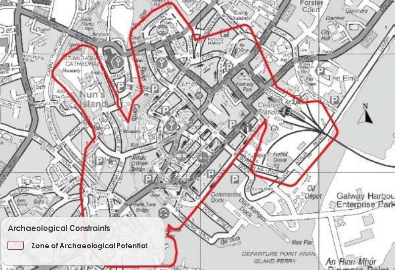
Planning & Environmental Scoping Study
Planning Report F1 – 2019.03.08 - 170503
Clearly define and delineate the area to which the study relates, including
description of the nature of the area at present to be informed by photographs
and aerial photography;
Provide a summary of the consultation that has taken place with Galway City
Council to-date;
Compile and interpret of all relevant planning policies and objectives,
particularly from the adopted Galway City Development Plan 2017-2023; in
addition to national and regional policies on urban regeneration, housing
delivery, sustainable communities, smarter travel, etc.;
Provide a summary of relevant planning permissions in the area pertinent to
any redevelopment proposal that might be provided for under a future
masterplan;
Detail the environmental considerations that the design team should be aware
of (e.g. proximity to the River Corrib Special Area of Conservation SAC,
qualifying interests of that SAC, likelihood of requirements for Appropriate
Assessment, etc.); and
Identify the key planning items that must be considered and addressed in any
future masterplan for the subject lands.
1.2 Structure of the report
Following this Introduction section, the Scoping Report is set out as follows:
Section 2 Provides a description of the defined study area’s context within the
surrounding area.
Section 3 Details the pertinent environmental, built heritage and archaeological
constraints relevant to the study area.
Section 4 Provides as summary of the study area’s unique strength and
challenges from a planning and urban design perspective.
Section 5 Outlines the consultation exercise which have informed the project to
date
Section 6 Summarises the statutory national and local planning policy context
relevant to the study area
Section 7 Provides a summary of relevant planning permissions in the area
pertinent to any redevelopment proposal that might be provided for
under a future masterplan.
Section 8 Summarises the key planning matters that must be considered and
addressed in any future masterplan for the subject lands.
Section 9 Concludes the main findings of the Scoping Study.
2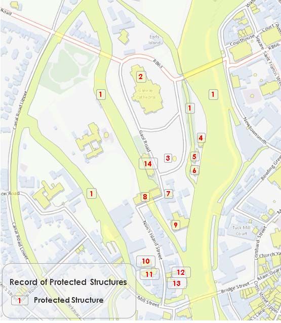
Planning & Environmental Scoping Study
                                                                Planning Report F1 – 2019.03.08 - 170503

2     MASTERPLAN AREA DESCRIPTION

2.1   Defined Study Area
      For the purposes of this Planning and Environmental Scoping Report (Scoping Report),
      the defined study area is illustrated in Figure 1 and 2 below. The study area extends to
      circa 6.3 ha and comprises a number of institutional, educational, residential,
      recreational, cultural and traffic/public transport related uses. A detailed description
      of the nature and character of the study area is provided in Section 2.3 below.

      Figure 1: Study Area
      (Aerial image sourced from Bing Maps)

      Figure 2: Study Area – Notable Buildings
      (Aerial image sourced from Bing Maps)

                                                                                                      3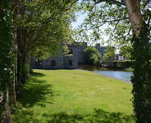
Planning & Environmental Scoping Study
                                                                Planning Report F1 – 2019.03.08 - 170503

2.2   Historical Development of the Study Area
      In the 19th century Nun’s Island was part of the industrial heartland of Galway. Historic
      6 inch maps (covering the period 1829-1841) tells us that the area comprised two
      lodging houses, Grace’s Asylum, the Presbyterian Church, a ladies’ school, a fever
      hospital, a County Gaol and Town Gaol, a brewery and malt house, two flour mills, a
      granite works, the Poor Clares Convent as well as the various residences. See Figure
      3 below. The 1897-1913 period saw further consolidation of the area and development
      of the canal system and waterfront area. See Figure 4 below. Construction of Galway
      Cathedral began in 1958 on the site of the old city prison. It was completed in 1965,
      making it the last stone cathedral to be built in Europe.

      Figure 3: Historic 6 Inch Map (1829-1841)
      Source: MyPlan.ie

                                                                                                      4
Planning & Environmental Scoping Study
Planning Report F1 – 2019.03.08 - 170503
Figure 4: Historic 25 Inch Map (1897- 1913)
(Source: Myplan.ie)
2.3 Description of the Character of the Study Area
The defined study area is located in the north-west inner city and forms a gateway to
the city from the west. The study area extends to circa 6.3 ha and comprises a number
of landuses, - including institutional, educational, residential, recreational, cultural
and traffic and public transport related uses. The site forms the transition between the
core city centre and the NUI Galway campus, in addition to being in close proximity to
University College Hospital, Galway. The area benefits from good public transport
links, including a number of city centre bus routes and private tourist coach services.
The site includes two city bike docking stations at Gaol Road and opposite the
Cathedral.
University Road forms the northern site boundary. The site is bound to the east by the
River Corrib and to the west by its associated canal system. The river basin and its
associated infrastructure is designated on the Record of Protected Structures (RPS
Ref. 8501). This stretch of the Corrib waterway also lies within the Lough Corrib Special
Area of Conservation (SAC) (Site Code: 000297). Nun’s Island is within Galway's Zone of
Archaeological Potential as outlined in the City Development Plan.
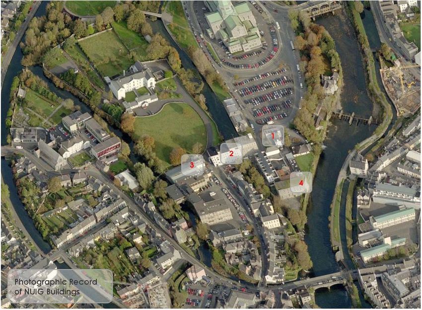
The defined study area contains a number distinct character areas. A photographic
record of the defined study area is provided in Appendix 2.
5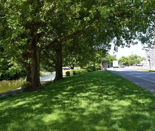
Planning & Environmental Scoping Study
Planning Report F1 – 2019.03.08 - 170503
Figure 5: Character Areas
The character of the defined study area can be described as follows:
The northern portion predominantly comprises the Cathedral, an extensive
surface public car park, recreational and amenity land bounding the river and
commercial office space located in Island House (RPS Ref. 3605). The area is
dominated by traffic based activities and surface car parking.
The southern area comprises a denser built development pattern than the
northern area:
o The area includes St. Joseph’s Patrician College, known as ‘The
Bish’, which was first established at Nuns' Island in 1862 and Nuns
Island Theatre (a fully equipped 82 seat theatre).
o This area also includes a number of three to six story buildings located
on Gaol road which are currently underutilised and falling into
disrepair (see Figure 6).
o The southern area of Nun’s Island Street predominantly comprises a
streetscape of two to three storey terraces of predominantly 19th
century townhouses. The rear gardens of the dwellings mostly back
onto the River Corrib.
6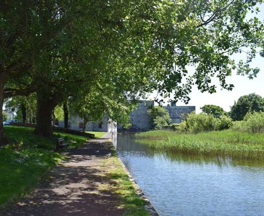
Planning & Environmental Scoping Study
                                                               Planning Report F1 – 2019.03.08 - 170503

Figure 6: Examples of buildings with redevelopment potential

Plate 1: Underutilised Building with Redevelopment Potential (NUIG Building No 57)

                                                                                                     7
Planning & Environmental Scoping Study
Planning Report F1 – 2019.03.08 - 170503
Plate 2 & 3: Underutilised Building with Redevelopment Potential (NUIG Building No 69)
Plate 4: Underutilised Building with Redevelopment Potential (NUIG Building No 56)
8Planning & Environmental Scoping Study
Planning Report F1 – 2019.03.08 - 170503
2.4 Transport and Traffic
The defined study area is located in the north-west inner city and forms a gateway to
the city from the west. Figure 7 below illustrates the existing traffic management
measures in the study area. Galway City Council operate a long-term surface car park,
encompassing approximately 161 no. car parking spaces on Gaol Road, immediately
south of Galway Cathedral. Long-term stay car parks charge a fee of €4 per day. As
part of the Galway Transport Strategy (GTS) (discussed below in Section 6.3), it is
proposed to reduce the dominance of car parking within the city. The GTS
acknowledges that many of the existing car park sites within the city represent
development opportunity site which may be brought forward for redevelopment in the
future.
The GTS identifies University Road (which forms the study area’s northern boundary),
as part of the ‘Cross City Link’. This link consists of a central corridor traversing the
core city centre area which will be restricted to use by public transport vehicles,
pedestrian, cyclists and local access only. The GTS also identifies a number of
measures to improve the public realm and pedestrian accessibility in the study area,
including a proposed new pedestrian bridge adjacent to the Salmon Weir Bridge.
Figure 7: Nun’s Island Traffic Management Strategy
9Planning & Environmental Scoping Study
Planning Report F1 – 2019.03.08 - 170503
3 ENVIRONMENTAL AND BUILT HERITAGE
CONSTRAINTS
3.1 Built Heritage Constraints
The Planning and Development Act 2000 (as amended), provides measures for the
protection of architectural heritage. These include the establishment of a Record of
Protected Structures (RPS) and the designation of Architectural Conservation Areas
(ACAs). The Galway City Development Plan 2017 -2023 which was adopted in December
2016 includes a Record of Protected Structures in Schedule 3 of the policy document.
A significant number of buildings and structures within the city are deemed worthy of
protection and 622 are currently on Record of Protected Structures (RPS).
Figure 8: Protected Structures within Study Area
Whilst not located in a designated ACA, the defined study area contains a number of
Protected Structures, as illustrated below in Figure 8 and described in tabular format
in Table 1 below.
10Planning & Environmental Scoping Study
Planning Report F1 – 2019.03.08 - 170503
Table 1: Protected Structures within Study Area
No. RPS Name/ Address Description Special Interest
Ref
Technical/ Historical/
Including bridges, walling,
Rivers and Social/ Scientific/
1. 8501 embankments, piers and other
Waterways Archaeological/
associated infrastructure
Architectural
Cathedral, Earl's Architectural/ Social/
2. 3602 C17th stone carvings
Island Archaeological
Grave associated
3. 3606 Grave Historical
with Galway Gaol
Architectural/
County Club House,
4. 3604 Medieval stone carvings in ground Archaeological/
Earl's Island
Historical
Fisheries Offices, Multi Bay Single Storey with Dormer Limestone plaque.
5. 3607
Earl's Island Commercial Buildings Entrance gate and piers
6. 3607 As above As above As above
Former Mill, Nun's 3 Bay 3 Storey Former Industrial Architectural / Technical
7. 7409
Island Street building
Architectural/
Former Mill, Nun's Original industrial machinery water
8. 7406 Technical/
Island Street inlet under building. 2 IHS carvings
Archaeological
Formerly Persse's Social/ Artistic/
Distillery/ Hygeia Architectural/ Historical
9. 7408 8 Bay 4 Storey Building
Building, Nun's
Island Street
2 Bay 2 Storey Arts Centre. Former Architectural/ Social
Arts Centre, Nun's
10. 7407 Presbyterian Church. Boundary
Island Street
walls, gate piers and gates
2 Conjoined 3 Bay 2 Storey Architectural/ Social
24 Nun's Island Residential Building. Former Grace
11. 7403
Street Home. Inscribed plaque on front
facade, gate piers and railings.
Architectural
6 Nun's Island 3 Bay 3 Storey Residential Building.
12. 7402
Street Outbuildings to rear.
5 Nun's Island 3 Bay 3 Storey Residential Building. Architectural
13. 7401
Street HIS tiles.
13 Bay 2/3 Storey Commercial Architectural
14. 3605 Island House
Building. Former grain store.
11Planning & Environmental Scoping Study
Planning Report F1 – 2019.03.08 - 170503
3.2 Archaeological Constraints
Galway has a rich archaeological heritage, which extends from the Mesolithic,
medieval and post-medieval periods and includes considerable industrial archaeology.
The archaeological heritage of the City is protected by the National Monuments Act,
1930-2004. A list of sites, structures, features or objects of archaeological significance
known as the Record of Monuments and Places (RMP) is compiled nationally by the
National Monuments Service of the Department of Arts, Heritage, Regional, Rural and
Gaeltacht Affairs (DAHRRGA). Given the medieval legacy of Galway, most of the city
centre is designated a Zone of Archaeological Potential (ZAP) - see Figure 9.
The extant City Development Plan advises that in advance of any new development on
a site of archaeological significance or within the ZAP, there is a requirement for
consultation with the DAHRRGA. It is the policy of the Council to ensure that
development within an area of archaeological significance/potential does not adversely
impact on the archaeological heritage. The Council will have regard to any
archaeological advice received from the DAHRRGA when considering proposed
development.
Figure 9: Zone of Archaeological Potential
(Extracted from Figure 8.12 of Galway City Development Plan 2017-2023)
The defined study area and immediate surrounding area contains a number of National
Monuments, as illustrated below in Figure 9 and described in tabular format in Table
2 below.
12Planning & Environmental Scoping Study
Planning Report F1 – 2019.03.08 - 170503
Figure 10: Designated National Monuments within Study Area
13Planning & Environmental Scoping Study
Planning Report F1 – 2019.03.08 - 170503
Table 2: Designated National Monuments within Study Area
No. Record Scheduled Classification Description
No. for
Protection
In the chapel of St Nicholas in the
Cathedral of Our Lady Assumed into
Heaven and St Nicholas. The reredos above
the altar consists of four limestone panels
arranged so as to represent the coronation
of Our Lady by the Holy Trinity. Three of
these date to the mid-seventeenth century
(God the Father, God the Son, Blessed
Virgin) and the fourth (Holy Ghost) is a
modern carving. The older panels came
from the Pro-Cathedral in Middle Street
where they had been transferred from St
Nicholas' church some time in the early
19th century. Richard Pococke, who visited
GA094- Stone
1. 1 Galway in 1752, records these as follows:
139 sculpture
‘In the vestry on three large stones are cut
as big as human life, Our Saviour, the
Virgin Mary to the right, and to the right of
that God the Father and over his head the
Dove, they were dug up some where about
the church’ (Pococke 1752, 105). Originally
they probably were intended to form part of
an altar or tomb-surround that was never
completed. The panel depicting God the
Father formerly contained to the right of
the figure the unfinished carvings of a dove
and an angel with a censor. These were
removed when the panels were re-erected
in this chapel.
GA094- Mill -
2. 1 Description not available.
103001 unclassified
GA094-
3. 1 Causeway Description not available.
100033
GA094- Weir -
4. 0 Description not available.
100056 regulating
GA094- Mill - Description not available.
5. 1
104 unclassified
GA094- Water mill - Description not available.
6. 1
100051 unclassified
GA094- Description not available.
7. 1 Bridge
100031
14Planning & Environmental Scoping Study
Planning Report F1 – 2019.03.08 - 170503
3.3 Environmental Designations
The Habitats Directive (92/43/EEC) was transposed into Irish law by S.I. 94 of 1997, the
European Communities (Natural Habitats) Regulations 1997. Special Areas of
Conservation (SAC)s are marine and terrestrial areas of internationally importance
that have been designated for the protection of wildlife habitats and species (other than
birds), which form part of EU Natura 2000 network of ecologically significant sites
throughout Europe. Special protection measures should be applied regarding these
habitats of specified wildlife species, in order to ensure the survival and reproduction
in their distribution area. Two SACs designated areas exist in the city, the Galway Bay
Complex and Lough Corrib Complex.
The defined study area is bound to the east by the River Corrib and to the west by its
associated canal system. This stretch of the Corrib waterway also lies within the Lough
Corrib Special Area of Conservation (SAC) (Site Code: 000297).
Figure 11: River Corrib SAC
15Planning & Environmental Scoping Study
Planning Report F1 – 2019.03.08 - 170503
The key features on interest of the SAC are detailed below. Numbers in brackets are
Natura 2000 codes:
Oligotrophic waters containing very few minerals of sandy plains
(Littorelletalia uniflorae) [3110]
Oligotrophic to mesotrophic standing waters with vegetation of the
Littorelletea uniflorae and/or Isoeto-Nanojuncetea [3130]
Hard oligo-mesotrophic waters with benthic vegetation of Chara spp. [3140]
Water courses of plain to montane levels with the Ranunculion fluitantis
and Callitricho-Batrachion vegetation [3260]
Semi-natural dry grasslands and scrubland facies on calcareous
substrates (Festuco-Brometalia) (* important orchid sites) [6210]
Molinia meadows on calcareous, peaty or clayey-silt-laden soils (Molinion
caeruleae) [6410]
Active raised bogs [7110]
Degraded raised bogs still capable of natural regeneration [7120]
Depressions on peat substrates of the Rhynchosporion [7150]
Calcareous fens with Cladium mariscus and species of the Caricion
davallianae [7210]
Petrifying springs with tufa formation (Cratoneurion) [7220]
Alkaline fens [7230]
Limestone pavements [8240]
Old sessile oak woods with Ilex and Blechnum in the British Isles [91A0]
Bog woodland [91D0]
Margaritifera margaritifera (Freshwater Pearl Mussel) [1029]
Austropotamobius pallipes (White-clawed Crayfish) [1092]
Petromyzon marinus (Sea Lamprey) [1095]
Lampetra planeri (Brook Lamprey) [1096]
Salmo salar (Salmon) [1106]
Rhinolophus hipposideros (Lesser Horseshoe Bat) [1303]
Lutra lutra (Otter) [1355]
Drepanocladus vernicosus (Slender Green Feather-moss) [1393]
Najas flexilis (Slender Naiad) [1833]
Proposed plans and projects in the study area should consider DEHLG Guidance for Planning
Authorities on Appropriate Assessment of Plans and Projects in Ireland (2009) and potential
impacts identified in the Natura Impact Report (NIR) of the City Development Plan relating to
habitat loss and fragmentation, water quality, disturbance and in combination effects. The
Habitats Directive promotes a hierarchy of avoidance/protection, mitigation and compensatory
measures and is based on a precautionary approach.
16Planning & Environmental Scoping Study
Planning Report F1 – 2019.03.08 - 170503
4 STRENGTHS AND CHALLENGES OF THE STUDY
AREA
A summary of the study area’s unique strength and challenges from a planning and
urban design perspective are set out below:
Table 3: Summary Analysis of Study Area
Summary Analysis of Study Area
Strengths/Opportunities
The Nun’s Island area is identified in the Galway City Development Plan 2017-
2023 as a potential regeneration area. Policy 5.1 supports a joint initiative
between NUI Galway and Galway City Council to prepare a masterplan for the
regeneration of lands and buildings at Nuns Island.
Major route and Gateway to City Centre - (transition between the core city
centre and the NUI Galway campus, in addition to being in close proximity to
University College Hospital, Galway)
Unique setting on River Corrib
Waterways- recreational opportunities
Rich architectural and archaeological heritage- the subject lands contain a
number of Protected Structures and National Monuments
Significant landowners (e.g. NUI Galway and Galway City Council) with
potential to assemble development sites
Good public transport links, including a number of city centre bus routes,
private tourist coach services and bike docking stations
Underutilised/vacant buildings with potential to bring a wider scale benefit to
the city.
University Road is a designated ‘Cross City Link’ (Galway Transport Strategy)
Potential to improve pedestrian links over the River Corrib
Opportunity to provide enabling infrastructure to facilitate the future
regeneration of the study area
Opportunity to adapt/redevelop vacant buildings with ‘green’/sustainable
building technology
Challenges/Constraints
Poor public realm environment and lack of pedestrian crossing points
Prevalence of hard landscaping (particularly around Galway Cathedral)
Area is dominated by private car use
Constrained road/pedestrian network
Existing built development turns its back to the river
Ability to develop a shared vision (i.e. large number of stakeholders involved)
Adjacent to Lough Corrib Special Area of Conservation
The area contains several Protected Structures and National Monuments
Located within Zone of Archaeological Potential
17Planning & Environmental Scoping Study
Planning Report F1 – 2019.03.08 - 170503
5 CONSULTATION
The Nun’s Island area of Galway City has been identified in the adopted Galway City
Development Plan 2017-2023 as a potential regeneration area within the city centre.
Policy 5.1 supports a joint initiative between NUI Galway and Galway City Council to
prepare a masterplan for the regeneration of lands and buildings at Nuns Island.
As a significant landowner in Nun’s Island, National University of Ireland, Galway (NUI
Galway) is leading the preparation of a comprehensive masterplan for the area, with a
view to working in partnership with Galway City Council to develop a cohesive,
integrated regeneration proposal for the Nun’s Island area, to optimise the potential of
this underutilised city centre space and bring a wider scale benefit to the city.
To date, informal discussions have taken place with Galway City Council at senior and
departmental level. The opportunity to develop a strategic vision for the area has been
received favourably. On the back of these discussions, the local planning policy
framework has been updated to reflect the potential of the Nun’s Island Area. The
Galway City Development Plan includes a number of specific reference to the future
redevelopment potential of the subject lands. Further Policy 5.1 Enterprise supports a
joint collaborative initiative to prepare a masterplan for the regeneration of lands and
buildings at Nun’s Island. Policy 5.1 states the following:
“Initiate in conjunction with NUIG, the preparation of a masterplan for the
regeneration of lands and buildings at Nuns Island”.
There are a significant number of stakeholders with an interest in the proposed
masterplan area, including (but not limited to):
Galway City Council;
National University of Ireland, Galway
Waterways Ireland;
Inland Fisheries Ireland;
Office of Public Works;
Corrib Navigation Trustees;
Diocese of Galway;
St. Joseph’s Patrician College;
Existing landowners and residents etc.
Initial enquiries/expressions of interest in the lands have been received from several
private and public bodies, interesting in pursuing a range of civic, enterprise,
educational, cultural and recreational uses. In addition, existing landowner and
residents of Nun’s Island will be consulted and provided with an opportunity to inform
and shape the strategic vision for the area and be kept informed as the masterplan
unfolds.
18Planning & Environmental Scoping Study
Planning Report F1 – 2019.03.08 - 170503
6 PLANNING POLICY CONTEXT
The current statutory planning policy document for the subject lands is the Galway City
Development Plan 2017-2023. There are a number of other relevant planning policy
documents that inform the City Development Plan (CDP) and these are also
summarised in this section.
6.1 National and Regional Planning Policy Framework
6.1.1 National Spatial Strategy 2002-2020
The National Spatial Strategy (NSS) is a twenty-year planning framework designed to
deliver more balanced social, economic and physical development between regions.
Key to the strategy is balanced regional development. Under the provisions of the NSS,
Galway’s strategic location in the West region is reflected in its designation as a
Gateway in the NSS, which is defined as “a city having a strategic location nationally
and relative to their surrounding areas and providing national scale social, economic
infrastructure and support services”. A core objective of the NSS is to strengthen the
critical mass of the gateways.
With particular reference to Galway City, the NSS states that:
“Galway, with its population catchment, quality of life attractions, transport
connections and capacity to innovate with the support of its third level
institutions, will continue to play the critical role which has been essential in
activating the potential of the region.”
6.1.2 Draft National Planning Framework- Ireland 2040 Our Plan
The Department of Housing, Planning, Community and Local Government are currently
formulating a new National Planning Framework (NPF) to succeed the NSS. A Draft
Issues Paper has been published in February 2017. The purpose of this paper is to set
out the main issues and possible choices for the development of Ireland to 2040. It is
intended that the National Planning Framework will be a high-level document that will
provide the framework for future development and investment in Ireland, providing a
long-term and place-based aspect to public policy and investment, and aiming to
coordinate sectoral areas such as housing, jobs, transport, education, health,
environment, energy and communications, into an overall coherent strategy.
In relation to regional cities such as Galway, the Issues Paper notes the following:
“Ireland’s regional cities appear to offer significant potential to be the focal
point to drive growth and development in their regions. The regional cities are
all major centres of employment, third-level education and healthcare and are
accessible to the motorway network and other communications infrastructure
such as airports and ports”.
With regard to Galway’s population growth, Section 4.1 of the Issues Paper notes the
following:
“It is notable that of the five Cities (Dublin, Cork, Limerick, Galway, Waterford),
only the Galway built-up area experienced consistent population growth in
excess of the national average (31%) from 1996-2016, increasing in population
by more than 23,000 or 41%”.
19Planning & Environmental Scoping Study
Planning Report F1 – 2019.03.08 - 170503
6.1.3 Planning Policy Statement 2015
The Department of Environment, Community and Local Government’s (DECLG)
Planning Policy Statement 2015 encourages Planning Authorities to engage in active
land management by leading and managing the development process and ensuring
that land zoned for development comes into use in accordance with Development Plan
policy and in tandem with supporting infrastructure.
The policy statement acknowledges that creating a consolidated urban form fosters
the development of compact neighbourhoods and a critical mass which contributes to
the viability of economic, social, and transport infrastructure.
6.1.4 Regional Planning Guidelines for the West 2010 – 2022
The Regional Planning Guidelines (RPGs) for the West Region 2010 – 2022 provide a
framework for long-term strategic development in the West Region, which comprises
the administrative areas of Galway County Council, Galway City Council, Mayo County
Council and Roscommon County Council. The current RPGs were adopted in October
2010 and are set within the context of national planning policy, including the National
Spatial Strategy, providing a statutory link between national and local planning policy
and objectives. RPGs have become much more influential within the planning policy
hierarchy with the enactment of the Planning and Development (Amendment) Act 2010,
which requires all relevant Development Plans to comply with the RPGs.
The RPGs set out the aims for the West Region through a number of strategic policies
and objectives, including in relation to Economic Development, Population and
Housing, Transport and Infrastructure, Environment and Amenities, Social
Infrastructure and Community Development.
6.1.5 Guidelines for Planning Authorities on Sustainable Residential
Development in Urban Areas
The ‘Sustainable Residential Development in Urban Areas’ and the accompanying
‘Urban Design Manual: A Best Practice Guide’ (2009) set out the criteria on planning
for sustainable neighbourhoods under four main themes, namely, provision of
community facilities, efficient use of resources, amenity or quality of life issues and
conservation of the built and natural environment.
The Guidelines advocate an urban design and quality-led approach to creating urban
densities will be promoted, where the focus will be on creating sustainable urban
villages and neighbourhoods. A varied typology of residential units is promoted within
neighbourhoods in order to encourage a diverse choice of housing options in terms of
tenure, unit size, building design and to ensure demographic balance in residential
communities.
6.1.6 Sustainable Urban Housing: Design Standards for New Apartments
Guidelines for Planning Authorities
The DECLG published the Sustainable Urban Housing: Design Standards for New
Apartments Guidelines for Planning Authorities in December 2015. The new guidelines
are the result of an updating of previous Departmental guidelines published in 2007
and are intended to enhance consistency between local authorities as regards planning
requirements, affordability of construction and living standards for residents.
20Planning & Environmental Scoping Study
Planning Report F1 – 2019.03.08 - 170503
The focus of this guidance is on the apartment building itself and on the individual units
within it. The 2015 guidelines specify planning policy requirements for:
Internal space standards for different types of apartments, including studio
apartments;
Dual aspect ratios;
Floor to ceiling height;
Apartments to stair/lift core ratios;
Storage spaces;
Amenity spaces including balconies/patios; and
Room dimensions for certain rooms
6.1.7 Design Manual for Urban Roads and Streets
Design Manual for Urban Roads and Streets6 (DMURS) was published by the
Department of Transport, Tourism and Sport and the Department of Environment,
Community and Local Government in April 2013. DMURS provides guidance relating to
the design of urban roads and streets. DMURS encourages designers to give due
consideration to creating a ‘sense of place’ which is of core significance to the creation
of safe and more integrated street designs. The guidance document notes that four
interlinked characteristics influence the sense of place within a street, including:
Connectivity: The creation of vibrant and active places requires pedestrian
activity. This in turn requires walkable street networks that can be easily
navigated and are well connected.
Enclosure: A sense of enclosure spatially defines streets and creates a more
intimate and supervised environment. A sense of enclosure is achieved by
orientating buildings toward the street and placing them along its edge. The
use of street trees can also enhance the feeling of enclosure.
Active Edge: An active frontage enlivens the edge of the street creating a more
interesting and engaging environment. An active frontage is achieved with
frequent entrances and openings that ensure the street is overlooked and
generate pedestrian activity as people come and go from buildings.
Pedestrian Activity/Facilities: The sense of intimacy, interest and overlooking
that is created by a street that is enclosed and lined with active frontages
enhances a pedestrian’s feeling of security and well-being. Good pedestrian
facilities (such as wide footpaths and well-designed crossings) also make
walking a more convenient and pleasurable experience that will further
encourage pedestrian activity.
The DMURS guidance emphasises that these four characteristics represent the basic
measures that should be established in order to create people friendly streets that
facilitate more sustainable neighbourhoods.
6 Available on: http://www.housing.gov.ie/sites/default/files/migrated-
files/en/Publications/DevelopmentandHousing/Planning/FileDownLoad%2C32672%2Cen.pdf
21Planning & Environmental Scoping Study
Planning Report F1 – 2019.03.08 - 170503
6.2 Galway City Development Plan 2017-2023
The current statutory planning policy document for the subject site is the Galway City
Development Plan 2017-2023 (CDP), which was adopted by the City Council in
December 2016 and came in to effect on the 7th January 2017. The CDP includes a Core
Strategy and Settlement Strategy that notes the need to accommodate continued
population growth, in line with the City’s designation as a ‘Gateway’, in a sustainable
manner. In this regard, the adopted Settlement Strategy is primarily based on
consolidating the urban form of the City. The strategic goals of the CDP include the
following:
Promote balanced and sustainable economic development that will enable
Galway City to fulfil its role as a National Gateway and a Regional Centre,
providing sufficient employment opportunities and appropriate services.
Use the role of the Gateway to harness the strengths and maximise the
economic development of the region.
Provide for a built and natural environment that is of high quality and that
contributes to providing a good quality of life for residents and visitors and
affords sustainable transportation opportunities.
The Nun’s Island area of Galway City has been identified in the adopted Galway City
Development Plan 2017-2023 as a potential regeneration area within the city centre.
Policy 5.1 Enterprise supports the preparation of a comprehensive masterplan for the
area:
“Initiate in conjunction with NUIG, the preparation of a masterplan for the
regeneration of lands and buildings at Nuns Island”.
The CDP sets out a co-ordinated and integrated spatial framework for the continued
development of Galway City in a sustainable and inclusive manner. It is set within the
overall national and regional planning contexts, taking into account relevant national
guidelines published by the Department of Housing, Planning, Community and Local
Government.
6.2.1 Zoning Designations
The Galway City Development Plan 2017 -2023 incorporates land use zoning objectives
and development management standards and guidelines to be applied to future
development proposals in the city. The Council is required to manage development to
ensure that permissions granted under the Planning and Development Acts 2000 (as
amended) are consistent with the policies and objectives of the Development Plan.
Provision is made for a flexible application of standards and guidelines, in particular
circumstances where proposed development is otherwise consistent with the proper
planning and sustainable development of the area and achieves high urban design
quality. The achievement of the policies and the objectives of the plan and the
encouragement of good design, rather than the mechanistic application of
development standards, will be the aim of development management.
The designated zoning objectives pertinent to the study area are illustrated in Figure
12 overleaf.
22Planning & Environmental Scoping Study
Planning Report F1 – 2019.03.08 - 170503
Figure 12: Galway City Development Plan 2017-2023 Zoning
Designations
23Planning & Environmental Scoping Study
Planning Report F1 – 2019.03.08 - 170503
Table 4: Zoning Objectives
Zoning Permitted/Compatible Uses and Site Specific Objectives
Objective and
Description
Uses which are compatible with and contribute to the zoning objective, for
example:
• Buildings for the care of the health, safety or welfare of the public
• Residential institutions
• Educational establishments
• Places of public worship
• Community and cultural buildings
Institutional
• Burial grounds and associated services
and
• Outdoor recreational use
Community:
• Accommodation for Travellers
• Childcare facilities
To provide for
• Public utilities
and facilitate the
sustainable
Uses which may contribute to the zoning objectives, dependant on the location and
development of
scale of development, for example:
community,
•Residential uses on surplus institutional lands where some of the original open
cultural and
character of institutional lands is retained and a minimum 20% of the total site
institutional
area is reserved for communal open space. Note: This will not apply to similar
uses and
development granted and built under previous development plan policies where a
development of
higher open space standard was required pre-2005.
infrastructure
• Additional uses, which are allied to/or have established supporting relationship
for the benefit of
with the primary use on lands in the NUIG and GMIT campus such as collaborative
the citizens of
activities with industry and student accommodation.
the city.
Site Specific Objective:
CF lands at Fisheries Field, (Earls Island). The Council will consider the
development of part of these lands for residential and or commercial use of a
residential nature, where a significant cultural facility is proposed as part of the
development, subject to other planning considerations in particular design
standards, traffic safety, environmental suitability and where public access is
secured.
Uses which are compatible with and contribute to the zoning objective, for
example:
• Outdoor recreation
Recreational/ Uses which may contribute to the zoning objectives, dependant on the location and
Amenity: scale of development, for example:
•Development of buildings of a recreational, cultural or educational nature or car
To provide for parking areas related to and secondary to the primary use of land/ water body for
recreational and outdoor recreation
amenity uses • Public utilities
• Burial grounds and associated services
Site Specific Objective:
RA lands at NUIG in the vicinity of the Quincentenary Bridge. The Council will
consider the strategic requirements to link the northern and southern campus.
This will be subject to examination of all potential options, transport, visual and
environmental considerations and where it can be demonstrated that the preferred
option will have sustainable benefits.
24Planning & Environmental Scoping Study
Planning Report F1 – 2019.03.08 - 170503
Zoning Permitted/Compatible Uses and Site Specific Objectives
Objective and
Description
Uses which are compatible with and contribute to the zoning objective, for
example:
• Residential
Residential: • Residential institution
• Outdoor recreational use
To provide for • Accommodation for Travellers
residential • Local shops, local offices, licensed premises, banks & other local services •
development Buildings for education
and for • Childcare facilities
associated • Buildings for the care of the health, safety or welfare of the public
support • Buildings for community, cultural or recreational use
development,
which will Uses which may contribute to the zoning objectives, dependant on the location and
ensure the scale of development, for example:
protection of • Hotels, Guesthouses, Hostels and B&B’s
existing • Part conversion or extension of private residence to studio, office, childcare
residential facility or small enterprises by the occupier of the dwelling, at a scale as would not
amenity and will unduly interfere with the primary use of the dwelling
contribute to • Places of worship
sustainable • Public utilities
residential
neighbourhoods. Site Specific Objective:
• R zoned lands at Nun’s Island Street (St. Joseph’s school site). The design of
residential development shall have regard to the streetscape context and shall
also contribute to the protection and enhancement of the adjacent waterways.
Uses which are compatible with and contribute to the zoning objective, for
example:
• Warehousing/Storage
Commercial/ • Retail of a type and of a scale appropriate to the function and character of the
Industrial: area • Specialist offices • Offices of a type and of a scale appropriate to the
function and character of the area
To provide for • Light Industry
light industry • Accommodation for Travellers
and commercial • Childcare facilities
uses other than • Community and cultural facilities
those reserved
in the City Uses which may contribute to the zoning objectives, dependant on the CI location
Centre zone and scale of development, for example:
• General industry (small scale)
• Service retailing
• Residential content of a scale that would not unduly interfere with the primary
use of the land for CI purposes and would accord with the principles of sustainable
neighbourhoods outlined in Chapter 2
• Offices • Car parks (including heavy vehicle parks)
• Waste management facility
• Public transportation facility
• Public utilities
• Outdoor recreation
• Commercial leisure/indoor recreation
25Planning & Environmental Scoping Study
Planning Report F1 – 2019.03.08 - 170503
Zoning Permitted/Compatible Uses and Site Specific Objectives
Objective and
Description
• Places of worship
Site Specific Objective:
CI zoned lands on Shantalla Road, Nun's Island Street, and on the former
Connaught Laundry Site. Residential development on the full extent of these CI
zoned sites will be considered. The density of any residential development on these
sites will have regard to the surrounding context.
6.2.2 Development Management Standards
Section 11 (Part B) of the adopted Galway City Development Plan sets out Development
Management Standards for each zoning designation.
City Centre Residential Areas
Development Management Standards for residential development in the City Cenrre
Areas are set out in section 11.3.4. Key design issues include:
As per standards for Outer Suburbs except:
11.3.4 (a) General: New commercial development will not normally be
permitted in residentially zoned land in the city centre.
11.3.4 (b) Open Space: When residential content is proposed in commercial
developments in the city centre an area the equivalent of 30% of the gross floor
area of residential content shall be provided as open space except in certain
circumstances where the established form and layout would deem compliance
with this standard inappropriate.
11.3.4 (c) Bin Storage: Adequate storage for waste disposal shall be provided
on site.
11.3.4 (d) Car Parking Standard: Maximum 1 car parking space per dwelling:
For new developments in the city centre residential areas where a reduction
in car parking standards is considered acceptable by the Council on grounds
of urban design or sustainability, a transport contribution will be levied in lieu
of on-site parking spaces.
Commercial and Industry
Development Management Standards for Commercial/Industrial are set out in section
11.9.1. Key design issues include:
Maximum Site Coverage: 0.80
Maximum Plot Ratio: 1.25
Open Space Requirements: 5% of the total area of the site and 50% of the gross
floor area of residential content where a residential content is proposed.
Lands zoned RA or G shall not be included as part of the open space
requirement for development on commercial or industrial lands.
Maximum densities shall only be attainable under optimum site conditions
having regard to criteria such as height, open space and protection of
amenities.
In the case of infill development in an existing terrace or street, it may be
necessary to have a higher plot ratio in order to maintain a uniform
fenestration and parapet alignment or to obtain greater height for important
26Planning & Environmental Scoping Study
Planning Report F1 – 2019.03.08 - 170503
urban design reasons. In such circumstances, the Council may allow an
increased plot ratio.
Developments shall be required to provide an element of open space which
would include a landscaping scheme for the site having regard to screening of
boundaries and vehicle parking areas and to the visual appearance of the site,
in particular the area between the front building line and the front boundaries.
6.3 Galway Transportation Strategy
Galway City Council & Galway County Council, in partnership with the National
Transport Authority, have developed the Galway Transport Strategy (GTS), an
Integrated Transport Strategy for Galway City & Environs. The GTS sets out a series of
actions and measures, covering infrastructural, operational and policy elements to be
implemented in Galway over the next 20 years and sets out a framework to deliver the
projects in a phased manner.
To address these problems, Galway City Council's strategic objectives for transport
are:
to promote and encourage sustainable transport;
to manage the traffic in a way which maximises mobility and safe movement;
and
to maintain and develop/upgrade Infrastructure.
The GTS identifies University Road (which forms the study area’s northern boundary),
as part of the ‘Cross City Link’. This link consists of a central corridor traversing the
core city centre area which will be restricted to use by public transport vehicles,
pedestrian, cyclists and local access only. The GTS also identifies a number of
measures to improve the public realm and pedestrian accessibility in the study area,
including a proposed new pedestrian bridge adjacent to the Salmon Weir Bridge.
6.4 Other Policy Considerations
6.4.1 Living Cities Initiative
The Living City Initiative focuses on the regeneration of retail and commercial districts
and encouraging people to live in the historic centres of Cork, Dublin, Galway, Kilkenny,
Limerick and Waterford. The aim of the Living City initiative is to bring life back into the
heart of the relevant cities by offering tax relief for qualifying expenditure incurred on
the refurbishment or conversion of certain buildings where conditions are met.
The designated Special Regeneration Area in Galway City is outlined below in Figure
13.
27Planning & Environmental Scoping Study
Planning Report F1 – 2019.03.08 - 170503
Figure 13: Special Regeneration Area- Living City Initiative
Residential element of the initiative
The residential element of the Living City initiative provides for an income tax
deduction for qualifying expenditure incurred on the refurbishment or
conversion of a building for use as a dwelling over a ten-year period.
The building must have been constructed before 1915 and be located in a
Special Regeneration Area of the city in question.
The property must be occupied by the claimant as his / her sole or main
residence in order to avail of the income tax relief.
Commercial element of the initiative
The commercial element of the Living City initiative provides for capital
allowances over a seven-year period in respect of qualifying expenditure
incurred on the refurbishment or conversion of a property located in a Special
Regeneration Area for use for the purpose of retailing goods or the provision
of services within the State.
The amount of tax relief available under the commercial element of the
initiative is effectively capped at €200,000 for any individual project.
7 PLANNING HISTORY
A review of GCC’s Planning Register shows that there have been a number of
applications lodged within the defined Study Area boundary.
A detailed summary of the relevant planning history is provided in tabular format in
Appendix 3.
28Planning & Environmental Scoping Study
Planning Report F1 – 2019.03.08 - 170503
8 KEY PLANNING MATTERS TO BE CONSIDERED
Remit for Preparing a Masterplan
The Nun’s Island area of Galway City has been identified in the adopted Galway City
Development Plan 2017-2023 as a potential regeneration area within the city centre.
Policy 5.1 Enterprise supports the preparation of a comprehensive masterplan for the
area:
“Initiate in conjunction with NUIG, the preparation of a masterplan for the
regeneration of lands and buildings at Nuns Island”.
Stakeholder and Community Engagement
As a significant landowner in Nun’s Island, NUI Galway is leading the preparation of a
comprehensive masterplan for the area, with a view to working in partnership with
Galway City Council to develop a cohesive, integrated regeneration proposal for the
Nun’s Island area, to optimise the potential of this underutilised city centre space and
bring a wider scale benefit to the city.
To date, informal discussions have taken place with Galway City Council at senior and
departmental level. The opportunity to develop a strategic vision for the area has been
received favourably and agreement has been reached to progress the masterplan for
the subject lands. There are a significant number of other stakeholders with an interest
in the proposed masterplan area. Initial expressions of interest in the lands have been
received from several private and public bodies, interesting in pursuing a range of civic,
enterprise, educational, cultural and recreational uses. In addition, existing landowner
and residents of Nun’s Island will need to be provided with an opportunity to inform
and shape the strategic vision for the area and be kept informed as the masterplan
unfolds.
National Planning Policy Framework
National and Regional Planning Policy Context
Draft National Planning Framework
Regional Planning Guidelines for the West Region 2010-2022
Rebuilding Ireland
Sustainable Residential Development in Urban Areas, Guidelines for Planning
Authorities
Guidance for Planning Authorities on Appropriate Assessment of Plans and
Projects in Ireland (2009)
Living City Initiative
Local Planning Policy Context- Galway City Development Plan 2017-2023:
Policy 5.1 Enterprise: Initiate in conjunction with NUIG, the preparation of a
masterplan for the regeneration of lands and buildings at Nuns Island.
Zoning Objectives: Various zoning objectives on site (Institutional and
Community; Recreational and Amenity; Residential; Commercial/ Industrial).
Site Specific objectives applicable- refer to Table 4 above.
Development Management Standards (e.g. density, car parking, open space
etc.)
Relevant Planning History
See attached Appendix 3
Key Cultural Heritage and Environmental Constraints
14 no. Protected Structures
29You can also read