Ecological Assessment of Mount Dobson Ski Area, South Canterbury - Prepared for Mount Dobson Ski Area Limited (MDSAL) 30 Alloway St Fairlie 7925
←
→
Page content transcription
If your browser does not render page correctly, please read the page content below
Ecological Assessment of
                 Mount Dobson Ski Area,
                    South Canterbury

Prepared for                            Prepared by

Mount Dobson Ski Area Limited (MDSAL)   Kate Wardle
30 Alloway St                           Ecological Services
Fairlie 7925                            400 Galloway Road
                                        RD3
                                        Alexandra 9393

                                        15th April 2021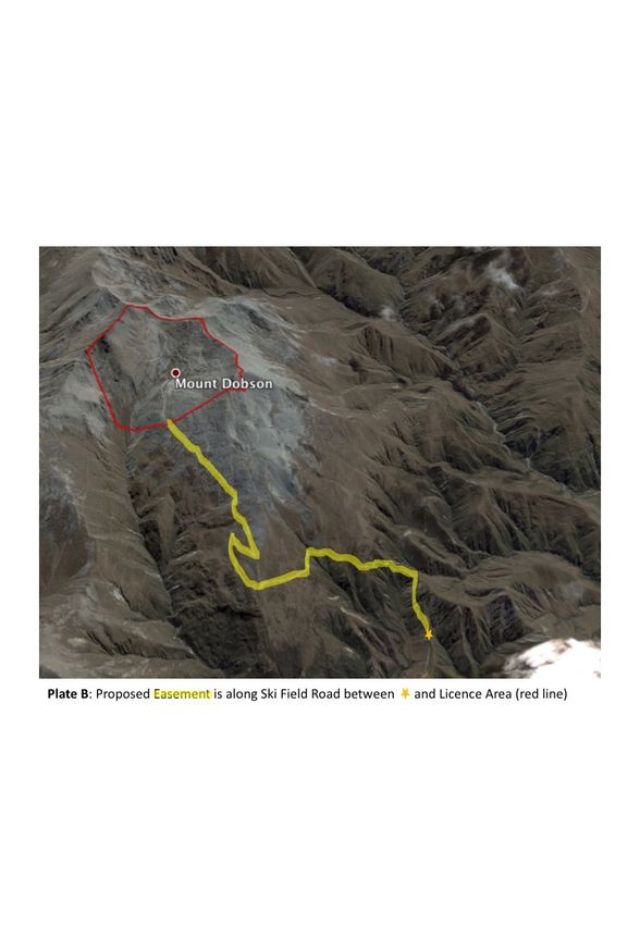
Front Cover: Plate A. Licence Area for Mt Dobson Ski Area shown in red
                                                2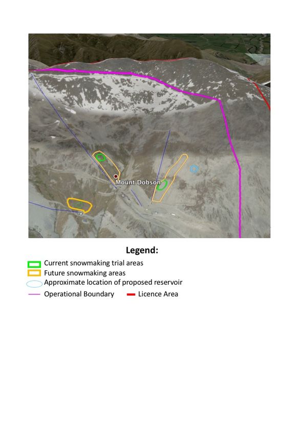
Table of Contents
1.     Introduction ................................................................................................................................... 5
2.     Mount Dobson Ski Area Development .......................................................................................... 5
3.     Ecological Character of Mt Dobson Ski Area .................................................................................. 5
4.     Ecological Context .......................................................................................................................... 6
5.     Ecology of Mount Dobson Ski Area ................................................................................................ 6
5.1.       Plant Communities.................................................................................................................... 8
       5.1.1.      Licence Area (Ski Field) ..................................................................................................... 8
       5.1.2.      Lease Area (Base Area) ................................................................................................... 11
       5.1.3.      Easement (Ski Field Access Road) .................................................................................. 11
5.2.       Animal Fauna .......................................................................................................................... 14
       5.2.1.      Bird Fauna ...................................................................................................................... 14
       5.2.2.      Invertebrate Fauna......................................................................................................... 14
       5.2.3.      Lizard Fauna ................................................................................................................... 14
5.3.       Threatened and At Risk Species .............................................................................................. 15
5.4.       General Ecological Condition .................................................................................................. 15
       5.4.1.      Licence area (Ski Field) ................................................................................................... 15
       5.4.2.      Easement (Ski Field Access Road) .................................................................................. 15
6.     Significance of Ecological Values.................................................................................................. 16
7.     Assessment of past effects of ski field establishment on indigenous biological diversity ........... 20
7.1.       Lease area (Base Area) ............................................................................................................ 20
7.2.       Licence area (Ski Field) ............................................................................................................ 20
       7.2.1.      Activities ......................................................................................................................... 20
       7.2.2.      Native vegetation regeneration ..................................................................................... 20
7.3.       Ski field access road - Easement ............................................................................................. 21
       7.3.1.      Weed Ingress.................................................................................................................. 21
       7.3.2.      Erosion Control Plantings ............................................................................................... 21
8.     Effect of on-going management on biodiversity ......................................................................... 21
8.1.       License Area (Ski Field) ........................................................................................................... 21
       8.1.1.      Snow Grooming .............................................................................................................. 21
       8.1.2.      Snow making .................................................................................................................. 22
       8.1.3.      Vegetation Removal for Pipe Laying .............................................................................. 23
8.2.       Ski field road management - Easement .................................................................................. 23
9.     Potential effects of proposed developments .............................................................................. 23
10.        Discussion ............................................................................................................................... 25
11.        Recommendations .................................................................................................................. 26
11.1.      Expert advice on Lizard values and Habitat ............................................................................ 26
11.2.      Verify resource consents held ................................................................................................ 26
                                                                           3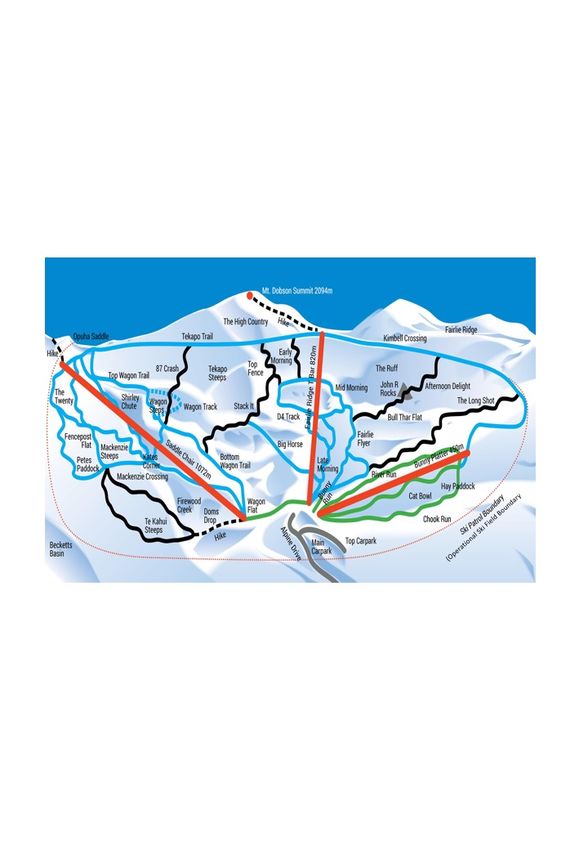
11.3.    Ecological Weed Control ......................................................................................................... 26
      11.3.1.        Californian Thistle ...................................................................................................... 26
      11.3.2.        Wilding Pines ............................................................................................................. 27
      11.3.3.        Catchment Board plantings ....................................................................................... 27
      11.3.4.        Gorse .......................................................................................................................... 27
11.4.    Animal Control ........................................................................................................................ 27
11.5.    No disturbance to Seepages and Streams .............................................................................. 28
11.6.    Vegetation Restoration ........................................................................................................... 28
11.7.    Easement Provisions for gravel processing and storage of ski lift equipment ....................... 28
11.8.    Update Standard practices for MDSAL site works to mitigate adverse ecological effects ..... 28
12.      References .............................................................................................................................. 29

APPENDICES

Appendix 1: Description of Priority Natural Area: Two Thumb Range Priority Natural Area 59-5-03:
Mount Dobson

Appendix 2: Trail Map – Operational Boundary of Mount Dobson Ski Area

Appendix 3: Plant Species List

Appendix 4: Photographs

                                                                         4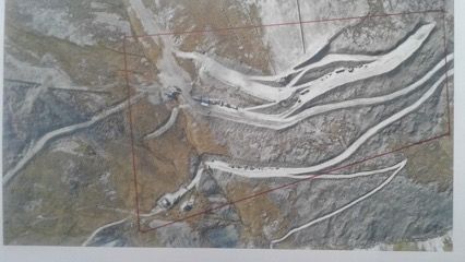
1. Introduction
Mount Dobson Ski Area Limited (MDSAL) is applying for a Department of Conservation Concession to
utilise approximately 350 ha at Mt Dobson in South Canterbury (Cover photo). It is located in Mount
Dobson Conservation Area, which is now part of Te Kahui Kaupeka Conservation Park. The
Department of Conservation is currently undergoing a process of requiring all ski fields that operate
on public conservation land to apply for a concession. MDSA has previously held licences under the
Crown Pastoral Lands Act.

This ecological assessment was requested by MDSAL to form part of their Concession Application. The
survey focussed on the botanical values, although casual observations and desktop research provide
some information on invertebrate, bird and lizard fauna values. The survey was undertaken on January
24th 2021. This report describes the vegetation communities present at Mount Dobson Ski Area, and
assesses the ecological impact of past, present and future ski field management. Recommendations
are provided.

2. Mount Dobson Ski Area Development
Skiing has taken place at Mount Dobson since 1979, when the first rope tows were installed. The
facilities have gradually been developed through time. Rope tows were replaced by a platter and T
bar, while a triple chair lift was installed in 2001 which opened up West Valley for skiing. Terrain
modification took place in the 1980s with a summer program of rock picking to improve the surface
of ski trails located on boulderfields, and the formation of tracks to provide access for skiers in the
winter, and ski field management throughout the year. Snow fences have been erected to improve
snow cover in high use or exposed part of the ski field. MDSAL is currently trialling snow making in the
beginners/intermediate area beside the Bunny Platter lift, and have plans to construct a reservoir to
supply water for snow making in the next five years.

3. Ecological Character of Mt Dobson Ski Area

Mt Dobson Ski Area is located on the southern end of the Two Thumb Range in South Canterbury. The
Licence area is located in an alpine basin to the south of Dobson Peak, and has an altitudinal range of
~1500 m to 2000 m asl.. The ski lifts currently service an altitudinal range from 1716 m at the chairlift
base, to 2018 m asl. at the T bar top station below Dobson Peak.

The environment is alpine, experiencing cold temperatures, a short growing season, and frosts at any
time of the year. The area lies within the rain shadow of the Main Divide, with predominantly north
westerly winds in the spring and autumn. Easterly and southerly winds are also common bringing
significant amounts of snow to the ski field area.

High alpine ecosystems are characterised by a having mostly bare ground cover. They support a
mosaic of plant communities that reflects changes in physiographic gradients such as snow
accumulation and duration, frost heave erosion, soil and moister gradients, and exposure. Soil
development is limited. These fellfields are sparsely vegetated, characterised by more or less stable
boulderfield, and less stable scree where surface stones are loose and sometimes mobile.

Below about 1800 m asl., soil accumulation has resulted in a wider range of low alpine vegetation
types to establish including tussockland, cushionfield, herbfield and wetlands.
4. Ecological Context
In pre human times, the alpine plant communities of the range summits in the Two Thumb Ecological
District are likely to have been similar to those present today i.e. sparsely vegetated alpine
boulderfield and stonefield communities, with cushionfield, herbfield and tall tussock grasslands
(Chionochloa species) present where soil accumulation has taken place (Leathwick et al 2003).
The ski field road passes through an altitudinal range of 990 m to 1700m asl. The original (pre-human)
vegetation on the hill slopes of the Two Thumb Range comprised a complex mosaic of low mountain
totara-hardwood forest, scrub and/ or Chionochloa snow tussock grassland depending on the site and
frequency of natural fires (McEwen, 1987; McGlone 2001; Harrington et al 1986; Leathwick et al 2003).
Human arrival about 850 years ago (Wilmhurst et al 2008), and associated burning caused widespread
loss of woody vegetation, which was replaced by high diversity ‘seral’ tussocklands and scrub below
1000m asl. (McGlone 2001). Subsequent European arrival and the introduction of large herbivores,
weeds and pests, have exacerbated ecosystem depletion (Walker et al 2006). In the 1970s such
depletion led to the retirement from grazing of the land that has subsequently become Mount Dobson
Conservation Area.
The Protected Natural Areas Programme (PNAP) survey of the Heron Ecological Region (Harrington et
al 1986) identified the following Recommended Area for Protection (RAP), in which the entire Mt
Dobson Ski Area Licence is part:
Priority Natural Area 59-5-03: Mount Dobson: Centred on Firewood Stream, this RAP includes alpine
boulderfield, scree and bluff, cushionfield and tussockland communities, as well as shrubland and
Hoheria lyallii shrubland on hillslopes at lower altitude. It includes good examples of high altitude east
facing cirque basins (see Appendix 1).
These values are still present.
5. Ecology of Mount Dobson Ski Area
Approximately 50% of the Licence Area lies beyond the current operational boundary and is in a
natural state. Survey effort concentrated on those areas of the Licence Area that are within the
operational ski field boundary.
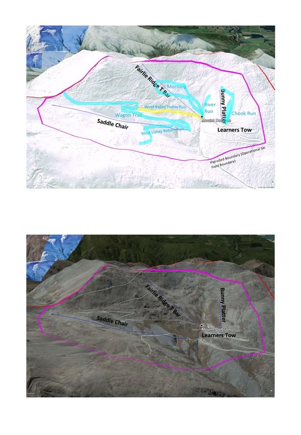
The location of the Licence Area and Easement for the access road are shown in Plates A and B on the
front cover. The location of ski trails and cat tracks referred to in the text, and within the operational
ski field boundary, are shown on the Trail Map (Appendix 2) and in Plate C.
6Plate C: Location of ski lifts, ski trails and cat tracks referred to in the report. Winter (above)
and Summer (below)
75.1. Plant Communities
Plant community names follow the structural class protocols of Atkinson (1985). A full species list is
provided in Appendix 3. Exotic species are denoted with an *. The photographic Figures are grouped
together in Appendix 4.
5.1.1. Licence Area (Ski Field)
Within the current operational ski field boundary, areas with vegetation cover are generally below
1800 m asl. and occupy the west facing slopes within the south-eastern quartile of the Licence area.
Low alpine plant communities occupying the fellfields here include tall tussockland, cushionfield,
herbfield and wetland communities. There are areas that appear to be induced boulderfield including
parts of Chook Run.
However, much of the Licence Area comprises high alpine fellfield with boulderfield and scree
habitats, that naturally support very little vegetation cover.
(i) High Alpine Veronica Boulderfield
Upper parts of the Licence Area i.e. below Dobson Peak and the adjoining ridges that enclose the head
of the catchment, and most of the terrain outside the current Operational Ski Field Boundary, are
characterised by thick colluvium and mass movement fellfield deposits, with rocky bluffs at 2000 m
asl. (Figures 1 & 2). These boulderfields are virtually unvegetated (Figure 3) but provide habitat for
occasional small cushions of speargrass (Aciphylla dobsonii, A. monroi), hebes (Veronica pinguifolia,
V. epacridea, V. haastii), vegetable sheep (Raoulia exima), South Island edelweiss (Leucogenes
grandiceps), scree willowherb (Epilobium porphyrium, E. pycnostachum) and white mats of Raoulia
youngii. Haastia sinclairiii can be found on coarse scree and partly stable rock debris.
Little hard fern (Blechnum penna-marina) and low growing porcupine shrub (Melicytus alpinus) grow
at the edge of stable boulderfields.
Within the current Operational Ski Field Boundary, Trails crossing boulderfield have been smoothed
out by summer rock picking i.e. where the larger rocks have been removed leaving the small more
consolidated rocks in situ. Aciphylla dobsonii, bristle tussock (Rytidosperma setifolium) and Veronica
epacridea grow on these Trails (Figure 4).
(ii) High Alpine Epilobium Stonefield
Where dry screes are comprised of small sized rubble, including on the groomed West Valley Return
Run returns skiers to the chair lift base, vegetation cover is sparse, but includes herbs - scree button
daisy (Leptinella atrata), scree willowherbs (Epilobium porphyrium, E. pycnostachyum) and occasional
tufts of mountain daisy Celmisia angustifolia); grasses - blue tussock (Poa colensoi), Rytidosperma
pumilum, Koeleria cheesemanii; sedge Luzula pumila, hebe (Veronica epacridea and V. pinguifolia)
(Figure 5). Penwiper (Notothlaspi rosulatum ) is uncommon.
(iii) Low Alpine Chionochloa Tall Tussockland
There is limited tall tussockland in the current Operational Ski Field Boundary and is largely confined
to 1680 m to 1800 m asl. (Figure 6).
8Slim-leaved snow tussockland (Chionochloa macra) is present on the gentler slopes between the T bar
and Platter lift lines (Figure 7). Tussock cover is greatest on the lower slopes here between the snow
fence to the north of the T bar line and the stream, where slim-leaved tussocks have 60% cover, with
bare or rock and rubble occupying to 25%. Other species present include blue tussock (5% cover),
narrow-leaved snow tussock (C. rigida 2%), trailing neinei (Dracophyllum pronum 1% cover) and
Celmisia viscosa (5%), with occasional Epilobium alsinoides, false spaniard (Celmisia lyallii),
Rytidosperma pumilum, and *king devil hawkweed (Pilosella prealta).
Further upslope, where slim-leaved tussock cover is more open, species diversity increases with
additional species comprised of cushion plants such as Veronica pulvinaris, Raoulia hectori var. hectori,
Raoulia grandiflora and Phyllachne colensoi, Luzula pumila, pin cushion, moss and lichen.
Localised depressions and shallow gullies where snow accumulates, support snow bank vegetation,
comprised of Chionochloa flavescens (40% cover), Celmisia haastii (20% cover), blue tussock, moss
Polygonum juniperum, trailing neinei, Phyllachne colensoi, Carex sp. and Anisotome flexuosa.
The most extensive area of tall tussockland within the Licence Area is located beyond the Operational
Ski Field Boundary, on the north-east facing slopes (1600-1480m asl.) in Firewood Stream.
(iv) Low Alpine Cushionfield/Celmisia herbfield
Within the Operational Ski Field Boundary cushionfield/Celmisia herbfield community is largely
confined to the northern basin, serviced by the T bar and platter lifts. There are also small patches in
West Valley, surrounded by boulderfield (Figure 8). At high altitude, cushionfield occupies relict cirque
basins and is generally in good condition. Dominant species include trailing neinei, Phyllachne colensoi,
cushion hebe (Veronica pulvinaris), blue tussock, and mountain daisy (Celmisia viscosa). Less common
species include Celmisia sessiliflora, Brachyscome longiscapa, Luzula pumila, Lindsay’s poa, and lichen
species.
At about 1750-1800m asl., cushionfield also occupies the drier faces (Figures 9 & 10). The most
common mat daisy present is Raoulia hectorii, var. hectorii which forms grey-green mats, while R.
grandiflora can form open silvery grey mats. Grey-green cushions of Veronica pulvinaris are common.
Other species that may be present include Luzula pumila, small pin cushions (Colobanthus strictus),
Anisotome flexuosa, the diminutive needle-leaved mountain daisy (Celmisia laricifolia) and grass
Rytidosperma pumilum. Trailing neinei with localised areas of D. prostratum, native daphne (Pimelea
oreophila subsp. lepta), bright green cushions of Phyllachne colensoi, patches of Celmisia angustifolia
and small speargrass (Aciphylla monroi) are present. Scattered tussocks grow amongst the cushion
plants including slim-leaved snow tussock (5% cover) and blue tussock. Naturalness and species
diversity is high. *Mouse eared hawkweed (Pilosella officinarum) can be present, especially closer to
the base area, and where ski field activities have disturbed the vegetation.
Moist cushionfields occupy the broad face above the chair lift base station, where alpine seepages are
present. Cushion hebe (Veronica pulvinaris) is common, as is *tussock hawkweed and Kelleria
dieffenbachii. Additional species present indicative of moister habitats include Schoenus pauciflorus,
Ourisia caespitosa, Caltha obtusa and comb sedge (Oreobolus pectinatus).
Snow groomer machinery has locally damaged the cushionfield vegetation in places including the
upper slopes of the ski racing and Chook Run area. Here the stems of Dracophyllum pronum have been
broken resulting in increased bare ground. Adjacent vegetation is healthy and more diverse.
9(v) Induced Low Alpine Stonefield
Vegetation cover of the bottom Chook Run is sparse. The stonefield present appears to be a
community induced from tussockland/cushionfield through historic vegetation removal (either
through development of the learner/intermediate area or through over-grazing) as there are some
areas that still support soil and vegetation (Figure 11). Vegetation cover is greater at the top of the
Platter Lift. However, this is a high traffic zone, as evidenced by scalped and/or dead tussocks of
Rytidosperma pumilum, snow tussock, and trailing neinei, and bare ground showing (Figure 12).
The area closest to the Bunny Platter Base comprises rock and rubble cover, with sporadic wood rush,
tufts of Rytidosperma pumilum, *browntop, hebe (Veronica epacridea) and Lindsay’s poa. In places
blue tussock is recolonising the stonefield (Figure 13), together with occasional slim leaved tussock,
creeping neinei, mats of Raoulia hectori and mountain daisy mats (Celmisia viscosa, C. angustifolia).
(vi) Low Alpine Herbfields – seepage
A small narrow stream, fed by numerous seepages, runs east-west across the centre of the Licence
Area, in the vicinity of the T bar base station. This community is very natural, and species diversity is
particularly high (Figure 14).
The moist stream sides support a low growing herbfield comprised of moss with intermingling
diminutive herbs and sedges including buttercup (Ranunculus maculatus), liverwort, creeping
willowherb (Epilobium brunnescens), native cress (Cardamine sp.), viola (Viola cunninghamii), kopoti
(Anisotome aromatica), Azorella sp, Isolepis aucklandica, sedge Carex pyrenaica var. cephalotes, pin
cushion Colobanthus affinis, and occasional forget-me-not (Myosotis drucei). More extensive patches
of montia (Montia sessiliflora), blinks (Montia fontana subsp. fontana) large white snow marguerite
Dolichoglottis scorzoneroides, Poa dispacea, willowherb Epilobium macropus and mountain daisy
Celmisia haastii occupy the splash zone.
Other species growing close to the stream include alpine rush (Marsippospermum gracile), purple
bidibid (Acaena fissisipula), mountain daisies (Celmisia viscosa, C. sessiliflora and C. angustifolia),
native dandelion (Taraxacum magellanicum), sedge (Carex lachanalii), pin cushion (Colobanthus
strictus), and Geranium brevicaulis. The uncommon sedge C. allanii has previously been recorded here
(Harrington et al 1986). Bladder fern (Cystopteris tasmanica) grows beside the boulders where the
water first emerges from the boulderfield. Numerous seepages that feed into the stream support a
similar range of species.
A small tarn is perched above the chairlift base station at the foot of boulderfield and is the source of
seepages that flow down towards the station (Figure 15). The low stature herbfield turf comprises
white caltha, willowherbs (E. brunnescens and E. komarovianum), cudweed (Argyrotegium mackayi)
kapoti, Celmisia angustifolia, button daisy (Leptinella pusilla), Acaena fissistipula, Isolepis aucklandica,
rush (Juncus pusillus); and cushions comprise mountain daisy C. sessiliflorum, Phyllachne colensoi, and
comb sedge (Oreobolus strictus).
The larger Firewood Stream flows in a north-east to south-west direction in West Valley. The Saddle
Chairlift and an access track cross it midway within the Licence Area. Species diversity is lower than
for the smaller stream described above. Key species include Montia sessiliflora, moss, Ranunculus
maculatus, Epilobium macropus, white caltha, and bidibid (Acaena fissistipula). Boulderfield extends
right down to the stream margin along the majority of its length (Figure 16). A water outtake pipe is
present where the West Valley Return Run cat track crosses the stream.
105.1.2. Lease Area (Base Area)
The Lease Area comprises approximately 10 ha at the base area (see Plate D). Vegetation cover has
been reduced or removed in much of the Lease Area. Earthworks were required during ski field
establishment and over the years to construct roads, carparks, beginners rope tow area, T bar and
Chair life base stations resulting in loss of vegetation within the construction footprint.
Plate D: Location of Lease Area
The Lease Area includes the bottom of groomed ski runs that take skiers to the T bar and chairlift base
stations. These high use areas are groomed, and being at lower altitude, tend to lose their protective
snow cover earlier than elsewhere within the Licence Area.
The vegetation communities present have been described in Section 5.1.1. The most natural
community within the Lease Area is the alpine herbfield associated with seepages and streams.
The bottom section of the Wagon Trail comprises a mosaic of slim tussockland and Celmisia herbfield.
A steep section of an old track located here blew out about 15+ years ago, but there is still a significant
area of gully erosion present (Figure 17). Bare rock and soil is apparent (35%), with cover of *mouse-
eared hawkweed reaching 30% in places. Scattered slim snow tussock, mats of mountain daisy
(Celmisia viscosa and C. angustifolia) and blue tussock are present.
Vegetation cover and condition is also modified in the high use areas at the base of the T bar, with
more rock and less snow tussock present.
5.1.3. Easement (Ski Field Access Road)
It is proposed that the ski field road has an easement concession encompassing 20 m each side of the
road formation. The easement will commence at the lower boundary of the Te Kahui Kaupeka
Conservation Park (880 m asl.) and continue the length of the road to the Lease Area ( ~1700 m asl.).
The road crosses several vegetation communities within this altitudinal range, most of which have a
high level of naturalness.
11(i) Montane Exotic Grassland
At the Mt Dobson lower boundary, the road initially passes through oversown and dressed pasture
(Figure 18) dominated by exotic species (80% cover) that include *sweet vernal, *Yorkshire fog,
*mouse-eared hawkweed. The cover of native species quickly increases going up the road. Native
species are regenerating and include narrow-leaved snow tussock, inaka (Dracophyllum longifolium),
porcupine shrub, mountain daisy (Celmisia semicordata), feathery tutu (Coriaria plumosa), hard
tussock (Festuca novae-zealandiae), blue tussock, willowherbs (Epilobium glabellum, E.
melanacaulon), viola (Viola cunninghamii), Anisotome flexuosa, and occasional mountain flax
(Phormium cookianum), and Coprosma dumosa. There are scattered wilding trees of the highly
invasive *lodgepole pine (Pinus contorta) present.
(ii) Montane -Subalpine Dracophyllum Shrubland
Dracophyllum shrubland is the dominant community in the montane zone, comprising Dracophyllum
rosmarinifolium, with some inaka and D. acerosum present (Figure 19). Other species present include
mountain flax, giant speargrass (Aciphylla scott-thompsoni), mountain daisies (Celmisia semicordata,
C. angustifolia and C. spectabilis var. magnifica); smaller herbs such as creeping mountain foxglove
(Ourisia caespitosa), parahebe (Veronica decora), hells bells (Anaphalioides bellidioides), creeping
willowherb (Epilobium brunnescens) and avens (Geum leiospermum); shrubs include hebes (Veronica
odora and V. pinguifolia), Gaultheria crassa, mingimingi (Coprosma dumosa, C. propinqua and C.
rugosa), prickly shield fern (Polystichum vestitum); lichen and moss. Occasional *lodgepole pine (Pinus
contorta), *gorse (Ulex europeaus), *grey willow, *alder and *tussock hawkweed are present.
On a west-facing slope Dracophyllum shrubland extends to ~1400 m asl. where it merges with tall
tussockland and has a diversity of native herb species (Figure 20). Snow clearing on the road has
resulted in localised areas of gravelfield to form below the road in the vicinity of the tussockland. This
provides habitat for native species adapted to unstable gravel including willow herbs (Epilobium
pycnostachyum and E. atriplicifolium) and Trisetum sp.
(iii) Montane *Willow Woodland
There are areas of *grey willow (Salix cinerea), *alder (Alnus glutinosa) and occasional *bitter willow
(Salix elaeagnos) that were originally planted below the road to control scree movement on the
recommendation of the Canterbury Catchment Board (Figure 21). Sporadic native ribbonwood
(Hoheria lyallii) are present amongst the exotic plantings (Figure 22). These plantings have spread into
adjoining areas, including occupying ribbonwood habitat down the stream gullies.
An area of planted *lodgepole pine beside the road has been felled, although a few live trees persist
at its edges, with many wilding seedlings present above the road (Figure 23).
(iv) Subalpine Wetland
At 1180m asl. wetland herbfield occupies the steam sides of a creek that flows under the road via a
culvert. Large hummocks of yellow flowered *musk (Mimulus moschatus) occupy the creek bed, while
bog rush (Schoenus pauciflorus) and curly tipped sedge (Carex petriei) form swards and tufts at the
stream side (Figure 24). Amongst the moss, willowherb (Epilobium macropus) and club rush (Isolepis
12aucklandica) are present. *Mouse eared chickweed (Cerastium fontanum), hellsbells and *Chewings
fescue (Festuca rubra subsp. commutata) are also present.
(v) Subalpine Hoheria lyallii woodland
Mountain ribbonwood (Hoheria lyallii) occupies gullies below the ski field road between 920m and
1130m asl. but only forms a woodland within the ski field road easement at 1130m asl. Mountain
ribbonwood is the dominant species. Some road fill has spilled over the side of the road close to the
ribbonwood woodland community, but native species including giant speargrass, hebe (Veronica
odora), Celmisia semicordata, and occasional narrow leaved snow tussock and Coprosma dumosa
have established in, and stabilized, the loose gravel material (Figure 25).
vi) Montane-Subalpine Stable Boulderfield
There are stable boulderfield tongues present within the ski field road easement some of which have
been cut through by the road formation (Figure 26). Boulders are about 40 cm across, with sparse
vegetation cover that has established between the rocks. Species include occasional tufts of blue
tussock, mountain shield fern (Polystichum cystostegium), mingimingi, lichen and moss.
(vii) Subalpine Chionochloa Tall Tussockland
Above about 1100 m asl., slim leaved snow tussockland becomes the dominant plant community
(Figure 27). On a south east facing slope, slim leaved snow tussocks have 60% cover, and Dracophyllum
rosmarinifolium (20% cover) being the dominant species. Additional species include narrow-leaved
snow tussock, trailing neinei (D. pronum) blue tussock, mountain daisies (Celmisia semicordata and C.
angustifolia), Coprosma dumosa (5%), hebe (Veronica odora), giant speargrass, pimelea, and
occasional creeping matipo (Myrsine nummularia).
At about 1400 m asl., intertussock species diversity is greater, with many low growing species present
including Brachyglottis lagopus, glaucus bidibid Acaena caesiiglauca, dwarf mingimingi (Leucopogon
fraseri), Acrothamnus colensoi, snowberry (Gaultheria depressa), mat daisy (Raoulia subsericea),
grassland daisy (Celmisia gracilenta), kopoti, and little hard fern. Exotic species are not extensive but
include *king devil and mouse-eared hawkweeds, and occasional wilding *contorta pine.
(viii) Alpine Boulderfields
Above about 1450 m asl., blocky unstable boulderfield dominates with very sparse vegetation present.
Species recorded include Luzula pumila, scree buttercup (Ranunculus crithmifolius), willowherbs
(Epilobium porphyrium and E. tasmanicum), and Lindsay’s poa where fine substrates have
accumulated.
(xi) Alpine Cushionfield
Cushionfield is locally present where some soil formation has taken place amongst the surrounding
alpine boulderfields (Figure 29). Trailing neinei dominates (80% cover), with scattered slim-leaved
tussock, small mats or cushions of Kellieria dieffenbachii, cushion hebe (Veronica pulvinaris), pin
cushion (Colobanthus strictus), Phyllachne colensoi and mat daisy (Raoulia hectori); mountain daisy
(Celmisia angustifolia), gentian (Gentiana corymbosa), blue tussock, clubmosses (Lycopodium
fastigiatum and Huperzia australiana) and lichen.
135.2. Animal Fauna
No specific animal fauna survey was undertaken as this is beyond my specialist knowledge. However,
surveys have been conducted on neighbouring Mt Hay Pastoral Lease for their tenure review
inspection, and findings from this were added to the casual observations made during the botanical
survey. These modest findings were discussed with an entomologist and herpetologist.
5.2.1. Bird Fauna
During the botanical survey, a pair of New Zealand pipit (Anthus novaeseelandiae novaeseelandiae)
were observed on open fellfield and boulderfield.
Although kea used to be recorded some 25 years ago (Peter Foote pers comm.), they have not been
observed since then.
5.2.2. Invertebrate Fauna
In lieu of a comprehensive invertebrate survey taking place, casual observations were made, including
photos, that were subsequently identified by the Department of Conservation entomologist Warren
Chinn.
Alpine grasshopper Brachaspis nivalis are present on rocky boulderfeld, while grasshopper Sigaus
australis was recorded in tussockland and on cushionfield.
Black mountain ringlet butterfly Percnodaimon merula was also observed on boulderfield and
cushionfield (Figure 30), especially on slopes near the platter lift, and within the Access Road corridor
at 1560m asl..
Drone fly Eristalis tenax was recorded feeding on nectar and pollen in a gentian flower growing beside
an alpine tarn (Figure 31).
These species are all representative of the alpine environment of the Two Thumb Range.
5.2.3. Lizard Fauna
No lizards were observed during the botanical survey. However, several species have been recorded
in scree habitat on neighbouring Mt Hay Pastoral Lease as part of its tenure review assessment (DOC).
There, the following endemic skink species scree skink Oligosoma waimatense, long-toed skink
Oligosoma longipes, and spotted skink Oligosoma lineoocellatum were recorded in screes and/or
boulderfield, while MacCann's skink (Oligosoma maccannii) and common skink (O. nigraplantare
polychroma) were recorded in stony habitats. One species of endemic gecko was recorded in stony
habitats and rock outcrops on Mt Hays - the common gecko (Hoplodactylus maculatus).
The alpine boulderfield and screefields at Mt Dobson Ski Area are likely to be excellent habitat for a
number of alpine lizard species (James Reardon pers. comm.). Reardon notes that this site is well
within the range of scree skink and the southern long-toed skink (now known as O. aff. longipes
“southern” or Roamatimati skink), and that Woodworthia “Southern Alps” gecko are also likely to be
there. Black eyed gecko (Hoplodactylus kahutarae), that are more commonly found further south,
may also be present in the alpine scree habitats at Mount Dobson Ski Area.
145.3. Threatened and At Risk Species
Herb Brachyscome longiscapa, found in cushionfield, has a threat status of At Risk – Naturally
Uncommon (Hitchmough et al. 2015). Sedge Carex allanii and herb Helichrysum plumeum have
previously been recorded (Harrington et al. 1986), and are also ranked At Risk - Naturally Uncommon.
Suitable habitat is present.
The boulderfields and cushionfields provide habitat for the recorded At Risk - Declining New Zealand
pipit (Anthus novaeseelandiae novaeseelandiae). While no lizard survey was undertaken, an expert
herpetologist expects the alpine boulderfields and screes to provide habitat to a suite of lizard species
including scree skink (Oligosoma waimatense) ranked Nationally Vulnerable and spotted skink
(Oligosoma lineoocellatum) ranked At Risk – Relict. A formal survey would be required to confirm this.
5.4. General Ecological Condition
5.4.1. Licence area (Ski Field)
While there has been permanent loss of vegetation cover within the construction footprint; and
modification to vegetation cover and terrain on tracks, where summer rock picking has taken place,
and on runs with high skier traffic, the vegetation of the remainder of the Licence Area is highly natural
and intact. The seepage-fed stream that flows past the T bar station is highly natural, but vulnerable
to ski field activities. Future developments, and current management in the vicinity of the stream must
take place without adversely effecting this significant community.
Very few exotic species are present. The vegetation communities support native fauna, including
invertebrates and birds, and is highly likely to be habitat for a diverse range of alpine lizards.
Wallaby and thar (both observed) and hare pose the greatest ecological pressure, as they browse
palatable native species including speargrass, some mountain daisy and snow grass. A small suite of
introduced plant species were recorded in the Licence Area and comprise *mouse-eared hawkweed
(Pilosella officinale), *king devil hawkweed (Pilosella prealta), *tussock hawkweed (Hieracium
lepidulum), *browntop (Agrostis capillaris) and *Californian thistle (Cirsium arvense). *Hawkweeds
are present at very low levels and are more likely to grow in areas close to the base area and where
skier traffic is higher such as ski runs just above the T bar and Chairlift base stations.
There is one small infestation of *Californian thistle present along a section of the West Valley Home
Run cat track that has revegetated with native species. *Thistles are starting to spread into the
adjacent highly natural cushionfield-herbfield community below the track. This is the only weed
infestation that poses immediate threat to the natural values on the Ski Area, and should be
eradicated while it is still of very limited distribution.
5.4.2. Easement (Ski Field Access Road)
There is greater diversity of introduced plant species present along the access road Easement, most
of which were confined to below 1200m asl. Species recorded include grasses *Yorkshire fog, *sweet
vernal and *Chewings fescue; herbs *mouse-eared chickweed, *hawkweeds, *musk, *Californian
thistle and *yarrow, shrub *gorse; and trees *lodgepole pine, *grey willow,* bitter willow and *alder.
15The invasive weed species of concern are lodgepole pine, gorse, grey willow, alder and bitter willow.
Wilding lodgepole pine are particularly invasive. They are present 882 m – 1500 m asl. within the Te
Kahui Kaupeka Conservation Park. Most are spreading from the felled Catchment Board stand beside
the road at 1060 m asl. (Figure 23) into a nearby road cutting, native shrubland and tussockland
communities.
On recommendation from the Canterbury Catchment Board, grey willow, bitter willow and alder were
planted to stabilise screes present on the lower section of the Easement, but have spread downstream
to occupy the streambed and sides, which is habitat for mountain ribbonwood (Hoheria lyallii).
One gorse bush was recorded in montane Dracophyllum shrubland, and warrants control before it
spreads further.
Californian thistle near the gravel stock pile is the likely source for the on-field infestation.
6. Significance of Ecological Values
The Lease Area, Licence Area and Easement are entirely located within the Two Thumb Priority Natural
Area 3: Mount Dobson. This PNA was identified approximately seven years after the initial ski field
development and included the Licence Area and Access Road despite some level of modification.
The alpine plant species found within the Licence Area are representative of the original vegetation
present in this environment of the Two Thumb Ecological District.
The significance of the ecological values found at Mount Dobson Ski Area was assessed using the
Department of Conservation guidelines (Davis et al. 2016) and are presented in Table 1.
16Table 1: Assessment of Ecological Significance
Representativeness
The Licence Area:
• Includes
Ecological Context the range of alpine vegetation communities and landforms that are representative of
the alpine zone in the Two Thumb ED.
The •Licence
A range
Area: of aspects, altitudes, landforms, levels of soil development and vegetation communities
are represented.
• The Licence Area is compact and well buffered by the surrounding expansive alpine
• environment
A diverse range of associated
with lizard species is expectedand
boulderfield to be
screepresent in the
habitats. alpine
These areboulderfield/scree/open
located elsewhere in
ground
the habitats;
Te Kahui expected Park
Conservation species
andwould be representative
adjoining pastoral leaseof the Two Thumb ED.
land.
• Ski field activities, including the ski field road, have facilitated the introduction of weed species,
Rating:atHigh
albeit very low levels. Within the Licence Area, hawkweed species are the main exotic
species, which are impractical to control.
Diversity
• Low & Pattern
levels of browsing by wallaby and thar is evident. Wild pest control is necessary.
Access Road:
The •Licence Area: of gravel from snow clearing and road grading does not appear to be increasing its
Overspilling
• Includes
footprint.aNative
rangeplant
of altitudes,
species areaspects and landforms
colonising these areas,that provide
especially sufficient zone
in subalpine environmental
variation to support a diverse range of vegetation communities
• Weed ingress is minimal. Of concern are gorse (1), wilding lodgepole (scattered), alder and
• Plant
willowspecies
(plantingsdiversity
and spread and from
species
theserichness
beyond theare road
particularly
corridor.high for wetland and flush
communities; and high for cushionfields
• Plant
Overallspecies diversity
ranking: M. Whenis lower for boulderfield
compared with other and scree communities,
undeveloped but that
alpine areas is toThumb
in Two be expected
ED,
for these alpine
naturalness rocky reduced
has been habitats due to historic and ongoing ski field activity. However, the level
• The predictedremoval
of vegetation diversityandof lizard
terrainspecies is high; is
modification this
onrequires expert
a par with Lakeconfirmation
Ohau Ski Area , and much
Rating: High
less than larger commercial ski fields such as Mt Hutt Ski Area. Some wild animal (wallaby and
thar observed) browsing. Weed ingress is minimal.
Rarity
• &habitat
Specialbelow
Featuresthe road and its proposed Easement. Remove and replace with native shrub
species.
The Licence Area:
• Includes
Rating: H/Mwetlands and seepages that are a national priority for protection as they have become
uncommon.
• Provides potential habitat for a number of lizard species that have been recorded on adjoining
land in similar habitat, including the Nationally Vulnerable scree skink (Oligosoma waimatense)
and At Risk - Relict spotted skink (Oligosoma lineoocellatum)
• Provides habitat for the recorded At Risk - Declining New Zealand pipit (Anthus novaeseelandiae
novaeseelandiae)
• Brachyscome longiscapa grows in cushionfield and is an At Risk – Naturally Uncommon plant
species
• Historic records of Helichrysum plumeum and Carex allanii classified as At Risk – Naturally
Uncommon not confirmed, but habitat is present
• This is the Type Locality for Aciphylla dobsonii, which is also a locally endemic species
• Several species reach their distributional limit here:
• Veronica buchananii – near its eastern distributional limit
• Veronica pinguefolia – near its western distributional limit
Rating: Medium/High. (Medium for Special Features; High for rarity if expert assessment finds threatened
lizard species to be present.Naturalness
The Licence Area:
• Much of the Licence Area has not been developed and remains highly natural
• Historical ski field development has required, and been consented for, the removal of
vegetation and/or substrate to form carparks, building platforms, cat tracks, lift lines, and a
beginner’s area. Decades ago, areas of scree and boulderfield have had summer ‘rock picking’
done to create a smoother surface for winter snow grooming on ski runs. More recently snow
fences have been erected, which have also required some vegetation clearance and rock
picking to create a smooth surface. All these activities have impacted on the naturalness of
those areas but is at a level that is expected at ski fields. Naturalness Rating: Low/Medium
• On-going effects of ski field activities e.g. use of tracked machinery for snow grooming and/or
summer use of diggers has created tracks in cushionfield and seepages, with evidence of
broken stems and reduced species richness at localised spots. Rating Medium/High
• Skier traffic in areas of low snow e.g. towards the bases of T bar and Triple Chair lifts has
possibly contributed to a shift from taller tussockland to low growing cushionfield/tussockland
with a higher occurrence of *hawkweed. Rating High/Medium
• Very few exotic plants present. Hawkweeds are present, but a small infestation of Californian
thistle above the Chair lift is just starting to spread further into natural vegetation cover and
requires control.
• Some localised browsing of alpine plants by wallaby and/or thar.
• Disturbance by e.g. rock picking and formation of cat tracks across boulderfields, while is a
visual scar, and locally modified the boulderfield habitat, it has also created new habitats for
other native scree plants adapted to growing in finer scree material. Rating High/Medium
Access Road:
• Overspilling of gravel from snow clearing and road grading does not appear to be increasing
its footprint. Native plant species are colonising these areas, especially in subalpine zone
• Weed ingress is minimal. Of concern are gorse (1), wilding lodgepole (scattered), alder and
willow (plantings and spread from these beyond the road corridor.
Overall ranking: Medium. When compared with other undeveloped alpine areas in Two
Thumb ED, naturalness has been reduced due to historic and ongoing ski field activity.
However, the level of vegetation removal and terrain modification is on a par with Lake Ohau
Ski Area , and much less than larger commercial ski fields such as Mt Hutt Ski Area. Some wild
animal (wallaby and thar observed) browsing. Weed ingress is minimal.
Rating: High/MediumEcological Context
The Licence Area:
• The Licence Area is compact and well buffered by the surrounding expansive alpine
environment with associated boulderfield and scree habitats. These are located elsewhere in
the Te Kahui Kaupeka Conservation Park and adjoining pastoral lease land.
• Boulderfields and screes are likely to be provide important feeding, and breeding habitat for a
number of lizard species, and provide an important linkage to other habitats within the
Conservation Park.
• Ski field activities, including the ski field road, have facilitated the introduction of weed species,
albeit at very low levels. Within the Licence Area, hawkweed species are the main exotic
species, which are impractical to control.
• Low levels of browsing by wallaby and thar is evident. Wild pest control is necessary.
Access Road:
• Overspilling of gravel from snow clearing and road grading does not appear to be increasing its
footprint. Native plant species are colonising these areas, especially in subalpine zone
• Weed ingress is minimal. Of concern are wilding lodgepole pine (scattered), gorse, alder and
willow (plantings and spread from these beyond the road corridor to habitat below the road
and its Easement). Remove and replace with native shrub species.
When compared with other undeveloped alpine areas in Two Thumb ED, naturalness has been reduced
due to historic and ongoing ski field activity. However, the level of vegetation removal and terrain
modification is on a par with Lake Ohau Ski Area and much less than larger commercial ski fields such
as Mt Hutt Ski Area. Some wild animal (wallaby and thar observed) browsing. Weed ingress is minimal.
Rating: High/Medium
197. Assessment of past effects of ski field establishment on indigenous biological
diversity
7.1. Lease area (Base Area)
The Base Area has experienced the greatest loss of vegetation and natural character, although the
main impact took place in the 1980s during the initial ski field establishment. The Lease Area
comprises 16 small buildings including the ticket office/café, ski school, ski club headquarters,
workshop, toilets, generator shed, ski hire rental and storage, Ski patrol, ski storage, administration
office, staff accommodation huts, pump shed, T bar and chair drive stations. The impact is largely
confined to the footprint of these Lease Area buildings but extends to the surrounding area where
there are carparks, a learner platter area (including Bunnies Run, and a bridge over the stream that
flows past the T bar base station.
7.2. Licence area (Ski Field)
Historic terrain modification within the Licence Area took place mainly in the 1980’s, resulting in
habitat modification, and/or total localised removal of vegetation cover. Activities included vehicle
track and lift line establishment, summer ‘rock grooming’, and creation of a beginner/intermediate ski
area.
7.2.1. Activities
(i) Tracks & Lift Lines
On the ski field, there are a number of vehicle tracks that were established to service the top stations
of the Bunny Platter lift, Fairlie Ridge T Bar and Saddle Chair. These not only provide summer vehicle
access for management purposes, but during the winter, act as cat tracks to give skiers an easy way
back down the mountain. The vegetation and some rocks along the alignments of the T bar and Platter
Lifts have been cleared to facilitate easy snow management (Figure 33).
(ii) Summer Rock grooming
Summer rock picking was carried out at locations where ski trails cross blocky boulderfield. This
practice entails removing rocks that jut out, so as to create a smoother surface that is possible to snow
groom and reduces the risk of skiers hitting protruding rocks. The ecological impact is the resulting
change from blocky boulderfield to more consolidated boulderfield with finer substrate between the
rocks. (See Figure 2).
(iii) Historic Vegetation Restoration
Approximately 35 years ago, Mt Dobson Ski Area was required to replant snow tussocks in a small
area where loss of vegetation cover was sustained during ski field development (Peter Foote. pers
comm.). This replanting effort has been successful.
7.2.2. Native vegetation regeneration
While all these practices have resulted in a reduction in natural vegetation cover, there is evidence
that alternative native species are colonising these modified areas, rather than exotic weed species
coming in. For example, the fine gravels created by the vehicle track under the Saddle Chair are
20colonised by scree plants including Leptinella atrata and willowherbs, whereas the surrounding block
boulderfield is more sparsely vegetated by hebe species (see Figure 3).
Natural regeneration is also evident along a section of West Valley Home Run above the Saddle Chair
line that is now well vegetated with native plant species including bidibid, Celmisia angustifolia, bristle
tussock, Anisotome flexuosa and Rytidoserma pumilum (Figure 35). The only exotic species present
are *mouse-eared hawkweed, (to 5% cover) and a localised infestation of *Californian thistle.
The bottom of Chook Run comprises boulderfield that is being recolonised by blue tussock,
occasionally leaved tussock, tufts of Luzula pumila and other native species (See Figure 11).
7.3. Ski field access road - Easement
The original road formation resulted in the outright loss of vegetation and landscape character within
its footprint, which includes some overspill of material in places down the side of the road.
Comparison of current aerial photos with historic ones (1980s) indicates that the extent of overspill
does not appear to have increased through time.
7.3.1. Weed Ingress
The road can act as a conduit for weed species, as seed can be transported in heavy machinery, and
the cuttings and overspill provide open habitat for establishment by weedy coloniser species. While
the lowest section of road corridor does have exotic species present, these are mainly pasture grasses
and herbs, and pose little threat to conservation values. Ecological weeds observed include occasional
*gorse, mainly seedling *lodgepole pine, *grey willow, *alder and *mouse-eared hawkweed.
7.3.2. Erosion Control Plantings
In the 1980s there was concern that the ski field road might exacerbate erosion where it cuts across
scree gullies in the lower sections within the Conservation Area. The Catchment Board at that time
recommended that exotic tree species be planted to stabilise these gullies below the road.
“The practice involved planting a range of seedling trees on mountain faces or gullies subject to
erosion. The trees were most likely planted as poles or stakes to control slips, gullies, debris avalanches
and to a lesser extent for frost heave, sheet wash, wind and creep erosion”. MfE (2001)
Lodgepole pine, grey willow, alder and bitter willow were planted in the gullies and gully-sides. The
invasive potential of these species into areas of indigenous vegetation has subsequently become
better understood.
8. Effect of on-going management on biodiversity
8.1. License Area (Ski Field)
8.1.1. Snow Grooming
Snow grooming takes place over many of the ski runs at Mount Dobson Ski Area. A snow groomer,
which is a tracked vehicle with a blade in front, and a cutter behind, is used to push snow ahead of it
21whilst smoothing out surface unevenness. While the majority of the ski field is at minimal risk of
damage arising from snow grooming because boulderfields are the dominant feature, several localised
areas of damage were observed.
On the upper slopes of the Chook Run, tracked snow groomer machinery has damaged cushionfield
vegetation on a steep pitch of track, as evidenced by broken stems of Dracophyllum pronum, reduced
plant diversity, and an increase in cover of bare ground (Figure 35). Adjacent vegetation is healthy and
more diverse. At Treble Cone Ski Area, direct damage by groomer blades and tracks to cushion plants
substantially reduced vegetation cover and cover of live cushion plants (Wardle & Fahey 2002), but
changes in species diversity of cushionfield between ungroomed and groomed trails were not
significantly different (Wardle et al 1005).
In the mid-section of Bottom Wagon Trail, moist cushionfield associated with seepages upslope has
been damaged by a tracked vehicle /snow groomer (Figure 36). The section is short (about 15 m long)
and comprises squashed vegetation including a turf of club rush with grass Deschampsia pusilla, and
mats of Celmisia angustifolia. The turf has been cut by the tracks, but vegetation cover and
composition is similar to the adjacent area; damage is minimal.
A change in species composition was apparent on the groomed slope above the Chair base station.
Tussock cover was reduced, with low growing cushionfield vegetation being more prevalent than on
the same slope further away from the base station. This may be a result of grooming and/or heavy
skier traffic.
8.1.2. Snow making
Minimal snow making has taken place to date, with only one mobile snowgun being used in areas of
high skier traffic i.e. close to the base of the T bar, towards the base of Bunny Platter and at the Chair
Base (Plate E). MDSAL is currently taking 15 litres/second of water from the small stream that flows
past the T bar base station, and from the larger stream to the west in West Valley to supply the mobile
snow making unit. Several outtakes are present, with pipes taking water down to a pump shed below.
Residual water flow is maintained, except at the highest outtake observed (GR E1412744 N5131753),
where that section of the seepage had no surface water left in it (Figure 37).
While there is no obvious sign of negative impact resulting from removing all the flow from the upper
section of the seepage/stream in terms of changes in species composition, species diversity, or ingress
by weed species, water flow within all the feeder seepages and the main stream should be maintained
at their natural flow when there is no demand for snow making i.e. from October until June. This
would be easily achieved through removal of the feeder pipe from the outtakes once the ski area has
closed.
Snow making, especially when used in conjunction with snow fencing, can have a positive
environmental impact because it enables a deeper snow pack to be maintained that better protects
the vegetation from damage resulting from skier and/or groomer traffic.
A perusal of the Environment Canterbury Consent Website suggests that MDSAL does not hold a
consent to take water for the purposes of snow making; MDSAL will need to sort this out prior to
submitting the application for a Licence with the Department of Conservation.
22You can also read