MANAGING MELBOURNE: Review of Melbourne Metropolitan Strategic Planning - STRATEGIC PLANNING AND FORECASTING DIVISION DEPARTMENT OF PLANNING AND ...
←
→
Page content transcription
If your browser does not render page correctly, please read the page content below
STRATEGIC PLANNING AND FORECASTING DIVISION
DEPARTMENT OF PLANNING AND COMMUNITY DEVELOPMENT

MANAGING MELBOURNE:
Review of Melbourne Metropolitan
Strategic Planning

APRIL 2012
This paper has been prepared by Lester Townsend in his role as Strategic Planning Consultant to the Strategic Policy, Research
and Forecasting Division of the Department of Planning and Community Development (DPCD). The views expressed are his own
and do not necessarily reflect those of DPCD or the Department of Transport (DoT). The identified lessons from this review are
not intended to be a comprehensive or definitive assessment of previous plans, but are intended to assist in identifying the
scope and approaches that may be suitable in the development of a new metropolitan planning strategy.
M A N AG I N G M E L B O U R N E : R E V I E W O F M E L B O U R N E M E T RO P O L I TA N S T R AT E G I C P L A N N I N G

             CONTENTS

             1.     INTRODUCTION
                    1.1  Sixty years of planning Melbourne 5

                    1.2   What can we learn from previous plans?                                             6

             2.     HISTORY OF METROPOLITAN PLANNING IN MELBOURNE

                    2.1   An expanding metropolis                                                            8

                    2.2   Metropolitan planning strategies                                                   9

                    2.3   Underlying aims                                                                   11

             3.     LESSONS FROM METROPOLITAN PLANNING

                    3.1   Connecting to Victoria                                                            14

                    3.2   Projecting growth                                                                 15

                    3.3   Shaping the city                                                                  16

                    3.4   Decentralisation: district centres, activity centres and central activity areas   18

                    3.5   Employment		                                                                      23

                    3.6   Housing			                                                                        23

             		           3.6.1		 Flats, units and townhouses                                               23

             		           3.6.2		 Inner urban housing                                                       25

             		           3.6.3		 Housing in activity centres                                               26

                    3.7   Urban renewal                                                                     27

                    3.8   Height, heritage and character                                                    30

                    3.9   Transport investments                                                             31

             		           3.9.1		 Roads and freeways                                                        31

             		           3.9.2		 Rail, Trams and Buses                                                     32

             		           3.9.3		 Bikes and walking                                                         33

                    3.10 Open space		                                                                       34

             PREVIOUS STRATEGIES		                                                                          36

                                                               3
M A N AG I N G M E L B O U R N E : R E V I E W O F M E L B O U R N E M E T RO P O L I TA N S T R AT E G I C P L A N N I N G

             LIST OF FIGURES

             Figure 1:     The growing footprint of Melbourne                                            8

             Figure 2:     Policies with a metropolitan impact                                           9

             Figure 3:     Regional context was explicitly addressed from 1995 onwards                  14

             Figure 4:     Changing population projections                                              15

             Figure 5:     Photo of transparent pages in 1971 plan                                      16

             Figure 6:     Activity Centres over time                                                   20

             Figure 7:     Principal Activity centres from 2002 Plan (Melbourne 2020)                   21

             Figure 8:     1960s flats were unpopular                                                   23

             Figure 9:     The 1960s flat boom                                                          24

             Figure 10:    Schematic for revitalising Activity Centres from Melbourne 2030              26

             Figure 11:    Pre 1980 ideas about renewal ignored local context and heritage              27

             Figure 12:    1984 Plan identifies elements of inner Melbourne                             28

             Figure 13:    From 1984 plan to reality, Southbank                                         29

             Figure 14:    1969 plan for freeways (green) and rail (red)                                31

             Figure 15:    From reservation to reality: 1968 reservation to constructed freeway         32

             Figure 16:    Cycling has grown in popularity                                              33

             Figure 17:    1954 and 1995 plans for open space                                           34

                                                              4
M A N AG I N G M E L B O U R N E : R E V I E W O F M E L B O U R N E M E T RO P O L I TA N S T R AT E G I C P L A N N I N G

             1.      INTRODUCTION

             In preparing the new metropolitan planning strategy it is worth reviewing previous plans for
             Melbourne to see what lessons we can draw.

             Melbourne is a city with a long history of strategic planning. Beginning with Robert Hoddle’s
             1837 street layout for what became the CBD. This has come to be known as the ‘Hoddle grid’.

             While there were no formal strategic plans for the city until 1929, town planning ideas, such
             as the Hoddle grid have influenced the layout of the Melbourne we know today.

             By the early 1910s concerns about the dilapidated parts of the city prompted major public
             inquiries by the Joint Select Committee on the Housing of the People in the Metropolis
             (1913-14) and a Royal Commission in 1915. These events led to the development of
             Melbourne’s first strategic plan in 1929.

             The 1929 plan of the Metropolitan Town Planning Commission proposed a planning scheme
             to prevent ‘misuse’ of land and protect property values, highlighting traffic congestion,
             the distribution of recreational open space and haphazard intermingling of land uses.
             The plan was not implemented and it was only after the Second World War, in the early
             1950s, that the planning system as we know it today commenced.

             This paper examines planning policies for Melbourne since 1954 and presents a number
             of ‘lessons’ – these are summarised in this introduction.

             The lessons in this paper are structured under a number of themes:
             •      Connecting to Victoria,
             •      Projecting growth,
             •      Shaping the city,
             •      Decentralisation: district centres, activity centres and central activity areas,
             •      Employment,
             •      Housing,
             •      Urban renewal,
             •      Height, heritage and character,
             •      Transport investments, and
             •      Open space.

                                                                 5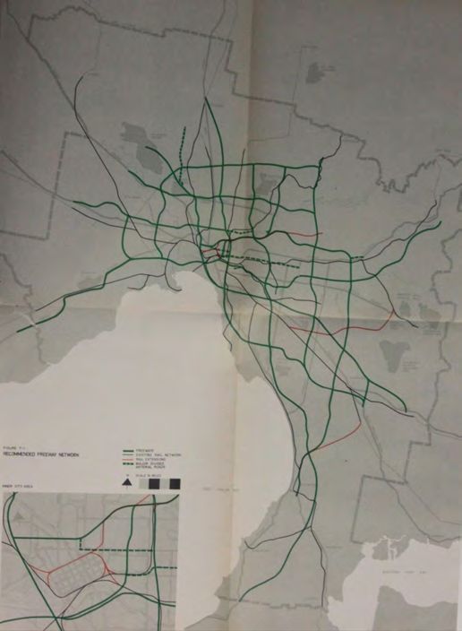
M A N AG I N G M E L B O U R N E : R E V I E W O F M E L B O U R N E M E T RO P O L I TA N S T R AT E G I C P L A N N I N G

             1.1     Sixty years of planning Melbourne
             Past plans for Melbourne have addressed a range of issues – though not all plans have addressed
             all the issues. Critical issues include:
             •      identifying how to strengthen links between Melbourne and regional Victoria,
             •      projecting population growth and proposing ways to manage that growth,
             •      identifying areas for suburban expansion to meet housing and employment needs,
             •      identifying areas of environmental or landscape value to be preserved,
             •      identifying activity centres and setting a vision for how they might be achieved,
             •      identifying areas for urban consolidation, or renewal,
             •      identifying the future transport network, and
             •      identifying open space improvements.

             In 1954 Melbourne recognised the need for planning and prepared a comprehensive plan,
             coupled with a proposed planning scheme. Since the preparation of that plan, Melbourne has:
             •      accommodated over two million  more people,
             •      built a freeway system,
             •      built the underground train loop,
             •      revitalised central Melbourne,
             •      increased public open space, created shared trails along waterways and created
                    regional parks,
             •      built the arts centre, a new museum, sports and entertainment centre, stadium at
                    Docklands and the exhibition centre,
             •      identified and protected heritage buildings,
             •      protected areas of natural value and landscape value,
             •      built a network of suburban shopping centres,
             •      built Monash and Latrobe Universities,
             •      built the Thomson, Cardinia and Sugarloaf dams.

             Melbourne is recognised as one the worlds most liveable cities, and is relatively prosperous.
             Looking at how previous plans have maintained liveability can help guide future thinking.

                                                               6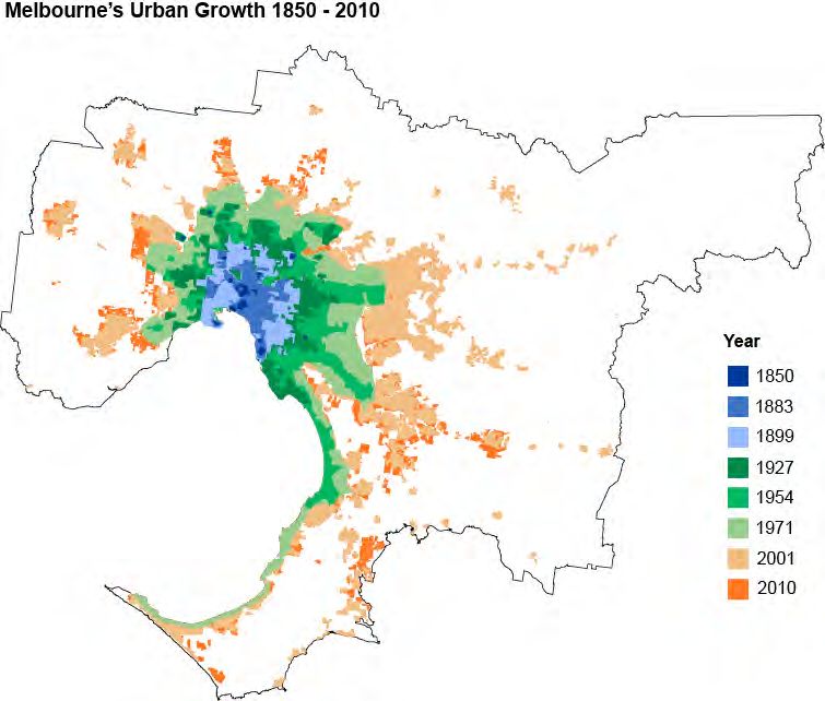
M A N AG I N G M E L B O U R N E : R E V I E W O F M E L B O U R N E M E T RO P O L I TA N S T R AT E G I C P L A N N I N G

             1.2     What can we learn from previous plans?
             Some planning approaches have been more successful than others. In trying to draw lessons
             from the past we might conclude:
             •      Melbourne must be understood in its wider State context and metropolitan strategies
                    must recognise the interaction of Melbourne with regional Victoria.
             •      It is better to think about planning for a proposed number of people, or a proposed
                    transport task, in the first instance and then deciding when this might be achieved as a
                    means of programming infrastructure.
             •      Protecting environmentally sensitive areas and areas of landscape beauty has broad
                    community support and where the green wedge boundary or Urban Growth Boundary
                    follows on-the-ground constraints or landscape values the boundary has endured.
             •      Metropolitan planning has not been successful in identifying sufficient development
                    potential for jobs and retail in activity centres. The district centre policy of the 1980s
                    underestimated the amount of floor space required. As a result, development took place
                    outside of centres.
             •      Past district centre/activity centre policies have had limited effect on shaping where retail
                    floor space, and suburban jobs and services, have been located. Controls to force office
                    development into centres did not work.
             •      State level services have been conceived of as ‘capital city functions’ and have remained
                    firmly planted in inner Melbourne. They have not been proposed for other centres in
                    Melbourne, or for that matter regional centres.
             •      Previous strategies have not developed a policy framework to tackle employment and
                    economic development in a systematic way.
             •      All proposals to ‘free up’ the construction of medium density or higher density housing
                    in suburban locations on a one size-fits-all approach have eventually been defeated by
                    public outcry, whether it was the 1960s flat boom, as-of-right dual occupancies, or the
                    Good Design Guide in the 1990s.
             •      Planning must now consider high rise suburban development. Building costs once
                    constrained high rise development in Melbourne to a few select locations. Now this form
                    of development is financially feasible across a far greater range of Melbourne suburbs.
             •      Higher density housing in and around activity centres in established and new areas has
                    become accepted planning practice (though it does not always meet with community
                    support).
             •      Urban renewal projects have been successful where they have been part of a broader
                    strategy of urban regeneration, and created an attractive public realm.
             •      Managing issues of height and character is an ongoing challenge.
             •      A long term plan based around maintaining opportunities for future transport projects,
                    that can be realised when needed, can have great success.

                                                               7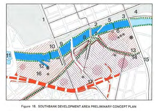
M A N AG I N G M E L B O U R N E : R E V I E W O F M E L B O U R N E M E T RO P O L I TA N S T R AT E G I C P L A N N I N G

             •      Public transport plans have been weak in identifying areas that are well served by public
                    transport, and at identifying a long term public transport vision.
             •      Proposals to covert Melbourne’s rail system into a Metro style system is a significant
                    recent change in thinking.
             •      Interest in planning for bikes and walking is relatively recent, and physical improvements
                    have lead to increases in the use of these modes.
             •      Open space planning has been part of metropolitan planning from the beginning and
                    Melbourne’s open space network has been gradually expanded and improved, notably
                    with open space along waterways

             Overall lessons
             The overall lessons from a review of previous strategies might be:
             •      Move beyond the generic, and the ‘top down’.
             •      Put mapped frameworks in the planning scheme.
             •      Use government investment or action as a catalyst.

                                                               8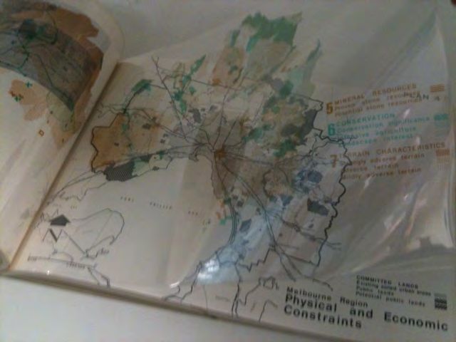
M A N AG I N G M E L B O U R N E : R E V I E W O F M E L B O U R N E M E T RO P O L I TA N S T R AT E G I C P L A N N I N G

             2.          HISTORY OF METROPOLITAN PLANNING IN MELBOURNE

             2.1           An expanding metropolis
             Melbourne was founded in 1835 and was officially declared a city by Queen Victoria in 1847.
             During the Victorian gold rush of the 1850s, it was transformed into one of the world’s largest
             and wealthiest cities. By world standards, today, Melbourne is a relatively low-density city.

             The pattern of growth in the 1950s clearly shows the city strung out along rail lines; cars were not
             generally available and people were more reliant on rail travel than they are today. In 1950 there
             were 160 cars for every 1,000 people in Victoria1, in 2006 there were 730.

             Development from the 1960s continued the growth along rail corridors but also included car-
             based suburbs within the established pattern of railway lines.

             Figure 1: The growing footprint of Melbourne

             Source: DPCD

             1
                 1954 figures from 1954 Surveys and Analysis page 169; 2006 figures from ABS

                                                                                 9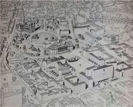
M A N AG I N G M E L B O U R N E : R E V I E W O F M E L B O U R N E M E T RO P O L I TA N S T R AT E G I C P L A N N I N G

             2.2      Metropolitan planning strategies
             Over the sixty years since this planning effort began more than 21 policies or plans with a
             metropolitan impact have been produced. Figure 2 lists these. Details of the policies are provided
             on page 37.

             Figure 2: Policies with a metropolitan impact
             1929        Plan for General Development
             1954        Melbourne Metropolitan Planning Scheme 1954 Report, Surveys and Analysis
             1967        The Future Growth of Melbourne
             1968        The Future Shape of Melbourne
             1969        Melbourne Transportation Study
             1971        Planning Policies for Metropolitan Region
             1974        Report on General Concept Objections
             1970-76     Statements of Planning Policy
             1980        Metropolitan Strategy
             1981        Metropolitan Strategy Implementation
             1983        District Centres policy
             1984        Central Melbourne: Framework for the Future
             1989        Plenty Valley Strategic Plan
             1989        Metropolitan Activity Centres
             1987        Shaping Melbourne’s Future
             1991        South East and Werribee Growth Area Plans
             1992        Cities in the Suburbs
             1994        Creating Prosperity: Victoria’s Capital City Policy
             1995        Living Suburbs
             1999        A better future for Victorians
             2002        Melbourne 2030
             2005        A Plan for Melbourne’s Growth Areas
             2008        Melbourne 2030: a planning update – Melbourne @ 5 million
             2008        Victorian Transport Plan
             2009        Delivering Melbourne’s Newest Sustainable Communities

                                                               10
M A N AG I N G M E L B O U R N E : R E V I E W O F M E L B O U R N E M E T RO P O L I TA N S T R AT E G I C P L A N N I N G
Of the many strategic plans that have shaped Melbourne since 1954, eight stand out for their
breadth or lasting impact. These are plans that were coupled with lasting changes to the planning
scheme, or significant capital works programs. The critical plans were:
1954 The Melbourne Metropolitan Planning Scheme 1954 Report, Surveys and
Analysis lead to the 1958 planning scheme with its system of zones for land use
control and particular provisions.
1969 The 1969 Melbourne Transportation Study identified the future freeway
network for Melbourne. In inner Melbourne which was, of course, already developed,
opportunities were limited. However, in undeveloped areas the plan was able to
identify optimum routes and reserve the land well in advance of development.
Though the proposed network was refined in 1973 by removing some of the more
controversial inner city alignments, it set the basis for the current freeway network.
1971 The Melbourne Metropolitan Board of Works plan, Planning Policies for the
Melbourne Metropolitan Region, introduced long-term conservation and
development policies through growth corridors and what we now call green wedge
principles, and contained outward growth to a limited number of areas on the edge
of the city. It looked at the physical constraints around Melbourne for the first time.
1970- Statements of Planning Policy introduced the idea that specific areas had
1976 qualities that ought to be recognised and protected. This is particularly the case
with the Upper Yarra Valley and Dandenong Ranges Regional Strategy Plan,
which continues to be specifically recognised in Section 46F of the Planning and
Environment Act 1987.
1980 The Melbourne and Metropolitan Board of Works (MMBW)’s Metropolitan Strategy
and subsequent 1981 Metropolitan Strategy Implementation encouraged
development in existing areas. The Metropolitan Strategy sought to concentrate
housing, transport, employment and community facilities at highly accessible points.
Following plans have repeated or reinforced these directions. In 1983, new district
centre zones encouraged office development in 14 centres and restricted
it elsewhere. Implementation included Amendment 150 which saw the introduction
of new zones and controls to the Melbourne Metropolitan Planning Scheme.
1994 Creating Prosperity: Victoria’s Capital City Policy laid the path for central city
revitalisation. Revitalisation of central Melbourne emphasised urban quality. The plan
identified renewal projects and emphasised urban quality and place making.
2002 Melbourne 2030 had a broadly similar strategic thrust to the preceding 20 years
but for the first time quantified the task of urban consolidation. It also introduced
an Urban Growth Boundary (UGB). The plan was expressed in the policy section
of ‘new format’ planning schemes based on the Victoria Planning Provisions (VPP)
and introduced progressively between 1997 and 2000.
2009 Delivering Melbourne’s Newest Sustainable Communities expanded the
Urban Growth Boundary and reserved land for the Regional Rail Link, Outer
Metropolitan Ring (a road and train corridor), and the land for grassland reserves
in Melbourne’s west.
11M A N AG I N G M E L B O U R N E : R E V I E W O F M E L B O U R N E M E T RO P O L I TA N S T R AT E G I C P L A N N I N G
2.3 Underlying aims
Looking back at the previous plans for Melbourne it is clear that the basic aims have been
constant, though expressed somewhat differently, as each plan adopted the language of its time.
All plans set out to:
• improve the efficient operation of the city,
• improve what we would now call its liveability, and
• preserve valued environmental areas.
The 1954 plan, in keeping with the times, presented itself as a technical response to a series of
‘problems’:
Behind this Planning Scheme lie three years of intensive research and work. The Board
does not claim to have produced a panacea for all the defects and weaknesses of
our city, but we do say that we have made an honest endeavour to give Melbourne a
practical and worthwhile plan. It is a means to a more efficient and more orderly city
and is designed to serve the public not become its master. It offers what the planning
staff and the Board considers is the best solution of many pressing and costly problems,
2
and the safest shield against recurrence of these problems in the future.
A number of the identified problems were to be solved by reference to what was taking place in
America, and the 1954 plan has a number of photos of developments in America.
By 1971 concerns had shifted slightly to include the need to preserve environmental values, as
well as create an efficient city:
The published plans are the first step towards making the most of efficient and
compatible use of land available, channelling urban development into growth
corridors within easy reach of open areas, making the best use of our existing systems,
conserving our resources, preserving areas for the future and developing in a way that
3
minimise future community costs.
In 2002 concerns about the quality of life or ‘liveability’ were more fully expressed:
In the next 30 years, Melbourne will grow by up to 1 million people and consolidate its
reputation as one of the most liveable, attractive and prosperous areas in the world for
residents, business and visitors.
The main thrust is to continue to protect the liveability of established areas and to increasingly
concentrate major change in strategic redevelopment sites.
Implementing the plans
Part of the history of metropolitan planning is not simply identifying policy directions for
Melbourne, but creating the statutory, machinery of government or capital works program tools
to implement those plans.
2
1954 Plan, page vii of Report foreword by John C Jessop, Chairman of the Board
3
Alan H Croxford, Chairman of the Board
12M A N AG I N G M E L B O U R N E : R E V I E W O F M E L B O U R N E M E T RO P O L I TA N S T R AT E G I C P L A N N I N G
The 1954 and 1971 plans both lead to significant planning scheme changes. The 2002 plan
(Melbourne 2030) introduced the Urban Growth Boundary, changed green wedge controls and
introduced new state policy. By this time the new format planning schemes were much more
policy driven and, so, Melbourne 2030 could be given effect without too many changes to zones
and overlays in planning schemes.
The introduction of the VPP in the late 1990s, followed by the 2002 plan (Melbourne 2030)
paved the way for a more comprehensive approach to detailed planning. It is only in recent times
that there have been explicit:
• Growth Area Framework Plans or Growth Corridor Plans,
• Precinct Structure Plans,
• Structure Plans for Activity Centres, and
• Green Wedge Management Plans.
13M A N AG I N G M E L B O U R N E : R E V I E W O F M E L B O U R N E M E T RO P O L I TA N S T R AT E G I C P L A N N I N G
3. LESSONS FROM METROPOLITAN PLANNING
A study of previous metropolitan policies can show where our current approaches have come
from, and can show us what has worked (and what has failed to work) in the past.
All plans address a similar range of issues, though with different emphasis:
• Connecting to Victoria,
• Projecting growth,
• Shaping the city,
• Decentralisation: district centres, activity centres and central activity areas,
• Employment,
• Housing,
• Urban renewal,
• Height, heritage and character,
• Transport investments, and
• Open space.
The changes between the plans reflect different strategic choices for achieving the broad
objectives of efficiency, liveability and environmental conservation, rather than changes in the
objectives themselves. For example, in one era inner urban renewal is seen as best achieved by
the demolition of substandard housing and building Housing Commission estates. In another, it is
seen as best achieved by the preservation and restoration of the existing housing stock.
14M A N AG I N G M E L B O U R N E : R E V I E W O F M E L B O U R N E M E T RO P O L I TA N S T R AT E G I C P L A N N I N G
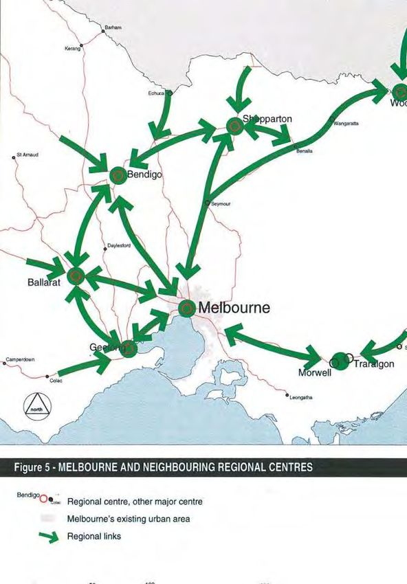
3.1 Connecting to Victoria
The 1987 plan was the first plan for Melbourne prepared by the State Government, as opposed to
the Melbourne and Metropolitan Board of Works, but it was only in the 1995 plan, Living Suburbs,
that the connection of Melbourne to regional Victoria was explicitly addressed in metropolitan
strategy.4
The 1995 plan provided a schematic showing Melbourne’s links to regional centres and set out a
range of explicit polices.
Figure 3: Regional context was explicitly addressed from 1995 onwards
Source: 1995 plan: Living Suburbs
Melbourne must be understood in its wider State context and metropolitan strategies must
recognise the interaction of Melbourne with regional Victoria.
4
It was addressed in the 1992 Shaping Victoria’s Future
15M A N AG I N G M E L B O U R N E : R E V I E W O F M E L B O U R N E M E T RO P O L I TA N S T R AT E G I C P L A N N I N G
3.2 Projecting growth
Most previous policies have been based on a future population, and a prediction of when that
population will be achieved. All metropolitan strategies have projected population growth. Some
projections have been more accurate than others, but all the projections have been realised:
some a little later than anticipated, some a little earlier. Figure 4 shows the actual and projected
population of a number of past plans. The 1954 plan underestimated growth; the 1971 plan
overestimated.
Figure 4: Changing population projections
6
5
4
2008
Population (millions)
2002
3
1995
1971
2
1954
1
0
1940 1950 1960 1970 1980 1990 2000 2010 2020 2030 2040
Actual population Projection 1971 1995 M2030 M@5M
Source: DPCD, relevant plans, ABS
There are two main implications of population projections: how much land, infrastructure
and services will be required when the city reaches the projected size; and how quickly the
land, infrastructure and services will need to be provided. An inaccurate forecast means that
infrastructure spending might need to be stepped up to keep pace with growth, or that there is a
little more time to deliver projects if growth is less than anticipated.
Planning for a large population increase in the 1971 plan (even though this took longer to be
realised, as the wide availability of the contraceptive pill slowed growth) delivered advantages in
providing longer term certainty around infrastructure delivery and allowed planning in the 1980s
and 90s to concentrate on other issues. It also allowed a longer-term view of transport issues to
be taken, identifying a proposed freeway network and introducing reserves that are still relevant
40 years later.
Recognising the difficulty of identifying both the population and the year it will be achieved,
recent thinking has emphasised the total population that needs to be housed, for example
‘Melbourne @ 5 Million’ rather than a specific year such as Melbourne in 2030 (as done in the
earlier Melbourne 2030 plan).
It is better to think about planning for a proposed number of people, or a proposed
transport task, in the first instance and then deciding when this might be achieved as a
means of programming infrastructure.
16M A N AG I N G M E L B O U R N E : R E V I E W O F M E L B O U R N E M E T RO P O L I TA N S T R AT E G I C P L A N N I N G
3.3 Shaping the city
The corridor plan and protection of development in the Yarra Ranges and Mornington
Peninsula were introduced in the 1970s. They have remained an enduring feature of planning
for Melbourne. Planning for growth based on detailed consideration of a range of constraints
continues to today.
In 1954 Melbourne did not extend much beyond what we would now call the inner and middle
suburbs, with some development along the existing train lines. Maps 5 and 6 of the 1954 plan
show the existing and planned density patterns. The selection of land for urban expansion
considered:
• the provision of drainage,
• utility services,
• the greater cost of servicing and street construction in the basalt areas of the north-west,
and
• that ‘people have a preference for the eastern and south-eastern and southern suburbs’.
The 1954 plan reinforced the established tendency of the city to grow to the south east.
The 1971 plan took the first comprehensive look at the constraints that surrounded Melbourne.
The plan even takes the trouble to present the constraints on a series of overlapping transparent
pages (Figure 5).
Figure 5: Photo of transparent pages in 1971 plan
Source: Photo by author
The 1971 plan adopted a ‘corridor’ approach to urban growth. Land between the corridors was
called ‘non-urban’, and we have come to call them green wedges (though these non urban areas
are not wedged shaped). The areas identified for conservation significance in this plan have been
enduring and from the basis of later restriction to growth.
17M A N AG I N G M E L B O U R N E : R E V I E W O F M E L B O U R N E M E T RO P O L I TA N S T R AT E G I C P L A N N I N G
Six functions for the non urban land were identified:
• conservation,
• landscape interest,
• extractive industry,
• intensive agriculture,
• general farming, and
• public use and utilities.
These plans did not include the Mornington Peninsula, and the Yarra Valley was initially a growth
corridor. The protection of the Peninsula and Yarra Valley from suburban development
was achieved in the Statements of Planning Policy released in the years immediately after the
1971 plan.
The south east green wedge has been narrowed over the years as the growth corridor has
crept into the wedge and developments such as the golf course and housing at Skye have been
approved. In the early 1990s substantial land was added to the west of the Cranbourne corridor,
narrowing the south east green wedge.
The green wedges were implemented through land use zones, with land identified for
preservation placed in zones such as the Landscape Interest Zone, and land for urban growth in
the Corridor Zone.
The 2002 plan (Melbourne 2030) introduced the concept of limits to urban expansion, that was
formalised through the Urban Growth Boundary, which excluded landscape and conservation
areas from urban development. It also excluded areas that had in the past been identified as
growth corridors, but included ‘possible future development’ fronts more or less where the
1971 plan had identified corridors.
Any jurisdiction that seeks to meet the demand for land by expanding its urban area must grow
somewhere; the approach in more densely settled parts of the world is to ‘leap frog’ green belt
areas and establish new settlements or encourage expansion of towns away from the main
centre.
Because Melbourne established a corridor plan expansion was always envisaged along the
corridor.
Support for the environmental values of the green wedges has been maintained in plans and is
stronger today than when first introduced. Those areas with landscape or environmental values
have been maintained as green wedges.
In 2009, Delivering Melbourne’s Newest Sustainable Communities expanded the urban growth
boundary, and there is now 2787 square kilometres within the Urban Growth Boundary; enough
land to cater for a city of about 4.5 million people if we maintained the same mix of densities that
we had in 2006.
Protecting environmentally sensitive areas and areas of landscape beauty has broad
community support and where the green wedge boundary or Urban Growth Boundary
follows on-the-ground constraints or landscape values the boundary has endured.
18M A N AG I N G M E L B O U R N E : R E V I E W O F M E L B O U R N E M E T RO P O L I TA N S T R AT E G I C P L A N N I N G
3.4 Decentralisation: district centres, activity centres
and central activity areas
The notion of district centres or activity centres has been a feature of successive metropolitan
strategies.
While most strategies have identified centres, the identified centres have changed from plan
to plan with only a few being a consistently identified. Major ‘freestanding centres’, Chadstone
in particular, have often been ignored in the plans.
The concept that the centres might reach a level of intensity, such that Melbourne becomes
a ‘polycentric’ city, is relatively recent.
Choosing centres
The 1954 plan nominated six ‘District Business Centres’: Central (Melbourne CBD), Footscray,
Preston, Box Hill, Moorabbin and Dandenong. The plan presented detailed plans of how these
centres might develop. These centres were the first recognition that central Melbourne could
no longer continue to serve the needs of the growing city and that some ‘decentralisation’
was required:
Some people might fear that urban decentralisation would react to the detriment of
the central business area and lead to a reduction in property values... Unless positive
steps are taken, the growing discomfort and inconvenience within the central area must
inevitably force businesses enterprises to decentralise in their own interests. The only
question is, “Will they decentralise according to a plan or without a plan?” 4
Looking at the details for the district centres in the 1954 plan shows they were very modest
proposals, not really much more than a few additional shops and some car parking in local
centres. It is interesting to note that one of the reasons for decentralisation put forward in
the 1954 plan was to better protect Melbourne from aerial bombing raids.
The 1971 plan introduced the ‘corridors’ and identified the need for centres in the corridors.
These are not explicitly named, but appear to be: Melbourne CBD, Craigieburn, Dandenong,
Frankston, Ringwood, Sunshine, Werribee, Mernda, and Lilydale5. These centres were only
identified in broad terms and district centre policy wasn’t really introduced until the 1980s.
In 1981 the Melbourne and Metropolitan Board of Works had determined that:
The Board will encourage and facilitate the development of designated major activity
centres spread strategically throughout the metropolitan area6.
4 1954 plan page 59
5 1971 plan 9 page 69 with reference to Plan 5 page 53 for location
6 1981 plan page 57
19M A N AG I N G M E L B O U R N E : R E V I E W O F M E L B O U R N E M E T RO P O L I TA N S T R AT E G I C P L A N N I N G
By the time district centre policy was introduced a number of free standing centres had been
established:
• Chadstone opened in 1960 as an open mall and in 1967 the mall was roofed over with
translucent fibreglass. It was built on the paddocks of the Convent of the Good Shepherd
which grazed cattle until the mid 1950s.
• Northland opened in 1966. A new bridge over the Darebin Creek at Murray Road was built
to provide access to the centre.
• Highpoint was opened in 1975 and was built on an old a quarry.
The 2002 plan (Melbourne 2030) expanded the notion of activity centres to give them a role in
catering for residential development.
Which centres?
Some centres, unsurprisingly, have a long history of recognition: Box Hill, Dandenong,
Footscray, Frankston and Ringwood. Other centres are included from time to time to try to shift
development and employment to new areas.
A feature of activity centres in Melbourne is the creation of new centres away from identified
activity centres. Planning policy has always been slightly ambivalent to these centres – on the
one hand, recognising their size and role in the retail hierarchy and, on the other, recognising that
these are essentially car-based retail centres, with their location driven more by land availability
than by public transport access, even though bus services have been provided to these centres.
The various plans have also struggled with how to deal with Melbourne’s shopping strips (some
kilometres long) in a theoretical framework that emphasises ‘centres’. From time to time, zoning
patterns or strategies have sought to develop nodes along the longer strips. Figure 6 identifies
the activity centres that have been identified in different plans.
20M A N AG I N G M E L B O U R N E : R E V I E W O F M E L B O U R N E M E T RO P O L I TA N S T R AT E G I C P L A N N I N G
Figure 6: Activity Centres over time
Shaping Melbourne’s Future
Central Activities Districts
Cities in the Suburbs
Melbourne 2030
Living suburbs
1954
1971
1981
1987
1992
1995
2002
2009
Airport West
Box Hill
Broadmeadows
Camberwell Junction
Oakleigh
Chadstone
Cheltenham, Southland
Craigieburn
Coburg
Cranbourne
Dandenong
Doncaster Hill
Endeavour Hills
Epping
Footscray
Forrest Hill
Frankston
Glen Waverley
Greensborough
Karingal
Keysborough
Lilydale
Maribyrnong, Highpoint
Melton
Mernda
Mill Park
Moorabbin
Moonee Ponds
Narre Warren, Fountain Gate
Pakenham y
Prahran/South Yarra y y
Preston, High Street
Preston, Northland
Ringwood
Sunbury
Sunshine
Sydenham
Wantirna South, Knox central
Werribee
Source: Relevant plans
Note: The Central Activities Districts are in addition to Principal and Major Activity Centres
21M A N AG I N G M E L B O U R N E : R E V I E W O F M E L B O U R N E M E T RO P O L I TA N S T R AT E G I C P L A N N I N G
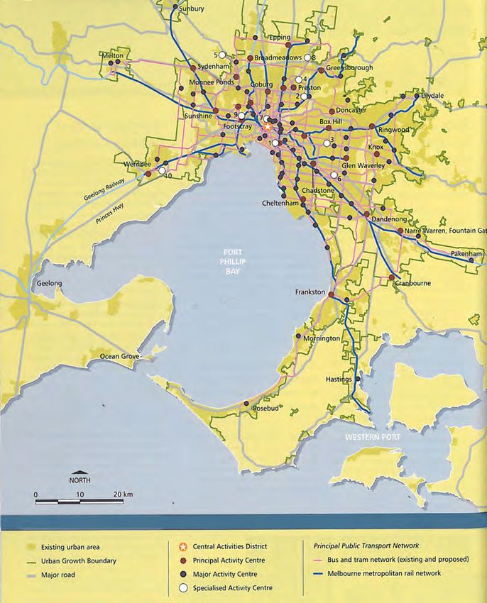
Figure 7: Network of Activity Centres from 2002 plan (Melbourne 2030)
Source: DPCD
22M A N AG I N G M E L B O U R N E : R E V I E W O F M E L B O U R N E M E T RO P O L I TA N S T R AT E G I C P L A N N I N G
Out of centre and new centres
In the 1980s planning controls were introduced to limit the size of offices that could be
developed outside of district centres. These controls were ultimately removed because there
were simply not enough development opportunities in the nominated activity centres.
There has always been a tension in planning for commercial and retail growth between a
‘sectorial approach’ (how much office/retail space do we need and where is that demand) and
a ‘spatial approach’ (here are the proposed district centres/activity centres and supply will be
provided in those centres). Metropolitan planning has not been successful in balancing these
tensions and the district centre policy of the 1980s simply underestimated the amount of floor
space required.
Hard or loose boundaries
At different times a lot of effort has gone into trying to define the boundaries of centres. It is
clear that some centres have grown over time while others have remained static.
Polycentric city
Melbourne @ 5 Million adopted the concept of a ‘polycentric city’ with the nomination of six
Central Activities Districts in addition to Principal and Major Activity Centres. It is fair to say, that
no district centre policy, however framed, has seriously proposed moving ‘capital city functions’
to one of the centres, for example, constructing a campus of the National Gallery of Victoria in
Frankston as opposed to the central city.
Metropolitan planning has not been successful in identifying sufficient development
potential for jobs and retail in activity centres. The district centre policy of the 1980s
underestimated the amount of floor space required. As a result, development took place
outside of centres.
Past district centre/activity centre policies have had limited effect on shaping where retail
floor space, and suburban jobs and services, have been located. Controls to force office
development into centres did not work.
State level services have been conceived of as ‘capital city functions’ and have remained
firmly planted in inner Melbourne. They have not been proposed for other centres in
Melbourne, or for that matter regional centres.
23M A N AG I N G M E L B O U R N E : R E V I E W O F M E L B O U R N E M E T RO P O L I TA N S T R AT E G I C P L A N N I N G
3.5 Employment
Employment has been discussed in general terms in various plans but has seldom moved beyond
a commentary on existing trends. Large areas have been identified for industrial uses, with
potential off site effects in Werribee and Dandenong.
The identification of employment corridors in the 2008 Melbourne @ 5 Million is probably the
first significant spatial policy for employment that moves beyond land supply for industrial uses.
Previous strategies have not developed a policy framework to tackle employment and
economic development in a systematic way.
3.6 Housing
3.6.1 Flats, units and townhouses
The 1954 plan did not see a need to increase densities in established areas. If anything, it
envisaged a slight decrease in urban density. It did, however, introduce a residential zoning
regime that provided four levels of density – Residential A, Residential B, Residential C and
Residential D - catering for residential development from inner urban terrace houses to low
density fringe development.
Until the 1970s, flat development was covered by the Uniform Building Regulations. Many of the
flats built in the 1960s did not require a planning permit. The 1971 plan envisaged ‘only limited
increases in population and employment within built up areas’. However it did note:
Flats and villa-units constitute some 40 percent of all dwellings now being erected.
This figure is a result of the flat boom of the 1960s. The boom was short lived, and with the
introduction of new residential design guidelines and public outcry over the perceived ugliness
of the flats, flat development lost its investment edge and new building activity virtually ceased.
Figure 8: 1960s flats were unpopular
1930s flats 1960s flats
Source: Photos by author
24M A N AG I N G M E L B O U R N E : R E V I E W O F M E L B O U R N E M E T RO P O L I TA N S T R AT E G I C P L A N N I N G
The 1981 plan expressed concern about the mismatch between housing stock and household
types and proposed dual occupancies, the redevelopment of old industrial sites in the inner
suburbs, and greater density and diversity in housing development in outer areas. By 1991-92
medium density developments had decreased to only 12 percent of all new dwellings.
Figure 9: The 1960s flat boom
Source: DPCD
The 1981 plan identified areas where there was a greater opportunity for housing diversity:
... these factors show that the greatest housing emphasis would need to be given
generally to the older established middle suburbs, notably in the east and south east
and the least emphasis in the inner suburbs.
At times the desire for urban consolidation, or housing provision, has lead to a freeing up of
the planning controls over medium density housing in existing areas. This freeing up has taken
the form of as-of-right permission for dual occupancies and standardised controls and policy
approaches to medium density housing in ‘VicCode’ (1993) and later the ‘Good Design Guide’
(1995). These approaches met with public outcry. The introduction of ResCode (Clause 55 in
the Victoria Planning Provisions) which looks to policy to determine location and neighbourhood
character to shape design has reduced some of these concerns.
All proposals to ‘free up’ the construction of medium density or higher density housing in
suburban locations on a one size-fits-all approach have eventually been defeated by public
outcry, whether it was the 1960s flat boom, as-of-right dual occupancies, or the Good
Design Guide in the 1990s.
25M A N AG I N G M E L B O U R N E : R E V I E W O F M E L B O U R N E M E T RO P O L I TA N S T R AT E G I C P L A N N I N G
3.6.2 Inner urban housing
The 1967 plan, The Future Growth of Melbourne, identified much of inner Melbourne as a
‘Redevelopment Area’. From 1954 to 1991, inner Melbourne lost dwellings and population and
there was a fear that Melbourne could become a ‘doughnut city’ − a place with no one living in
the inner suburbs.
In fact, the inner suburbs of Melbourne had experienced their peak populations in the years
immediately after the First World War. They declined over the next 70 years, losing as much as 66
per cent of their peak populations7.
The 1970s saw a renewed interest in inner Melbourne as heritage housing was protected, and
areas ’gentrified’. Owners, architects and builders developed a better understanding of heritage
values and many properties have since been restored.
In 1992 the City of Melbourne introduced its ‘Postcode 3000’ policy aimed at increasing
residential development in the Melbourne city centre, including the central business district and
St Kilda Road to 3000 people. The policy reviewed certain building regulations and provided
incentives for people living in the central area. Development saw the conversion of unoccupied
lower grade office buildings which because of a glut of office space had no real prospect of being
used as offices; total office vacancy rates were at their highest rates in decades.
In the early to mid 1990s higher density and high rise development began to feature more
prominently in Melbourne development. While there has always been a limited amount of high
rise buildings in Melbourne, most notably along the St Kilda foreshore, along St Kilda Road
and at Doncaster Hill, the mid 1990s saw high rise development spread to other areas of inner
Melbourne and then into middle-ring locations. While planning policies broadly supported this
spread, actual construction was made possible due to rises in the price of housing and decreases
in the cost of construction as a result of changes in construction methodology.
Planning must now consider high rise suburban development. Building costs once
constrained high rise development in Melbourne to a few select locations. Now this form of
development is financially feasible across a far greater range of Melbourne suburbs.
7 Department of Infrastructure, 1998, From Doughnut City to Café Society, page 3
26M A N AG I N G M E L B O U R N E : R E V I E W O F M E L B O U R N E M E T RO P O L I TA N S T R AT E G I C P L A N N I N G
3.6.3 Housing in activity centres
The 2002 plan, Melbourne 2030, introduced the notion that activity centres were a location for
higher density housing – up until this point activity centres had a commercial focus. Certainly
there was discussion in the 1980s about ‘shop top housing’ but this form of development did not
attract much developer interest. This changed with the release of the 2002 plan.
In some ways the residential interest in activity centres was an extension of the interest in
residential development in central Melbourne.
The aim of increasing residential development in activity centres was twofold:
• it was seen as a way of helping make car based activity centres ‘work better’, and
• it was a good location for housing to meet the need for infill for infill housing in
established suburbs.
Higher density housing in and around activity centres in established and new areas has
become accepted planning practice (though it does not always meet with community
support).
Figure 10: Schematic for revitalising Activity Centres from Melbourne 2030
Source: Melbourne 2030, Department of Infrastructure, 2002.
27M A N AG I N G M E L B O U R N E : R E V I E W O F M E L B O U R N E M E T RO P O L I TA N S T R AT E G I C P L A N N I N G
3.7 Urban renewal
Part of planning for Melbourne has included identifying areas that need to be ‘renewed’. The approach
to renewal has shifted significantly from 1954 to today. Metropolitan strategies have generally not
always identified urban renewal projects, but plans for Central Melbourne have.
Urban renewal began (badly) with the development of high rise housing commission estates in inner
Melbourne. The housing commission high rise had its genesis in the 1954 plan:
Proper redevelopment of a really decadent area rarely, if ever, comes about, except in
accordance with a comprehensive plan.8
This renewal activity was typical of the large scale projects proposed. Figure 11 shows the 1954
plan’s vision for the land around Parliament House, together with a later proposal for the
Queen Victoria Market.
Figure 11: Pre 1980 ideas about renewal ignored local context and heritage
Parliament precinct redevelopment from 1954 plan 1978 plan for Victoria Market ignored local context
Source: 1954 plan, Melbourne Metropolitan Planning Scheme Report, MMBW.
Since the 1980s the need for concentrated efforts at urban renewal has been recognised and a
number of significant renewal projects undertaken, primarily related to surplus government land in
inner Melbourne. There was a critical shift occurred in the way these projects were planned with a
much greater emphasis on the creating attractive liveable places.
8 1954 plan, page 38
28M A N AG I N G M E L B O U R N E : R E V I E W O F M E L B O U R N E M E T RO P O L I TA N S T R AT E G I C P L A N N I N G
The 1984 Central Melbourne: Framework for the Future identified a number of opportunities that
have since been realised:
• ‘La Trobe Central’ which lead to the development of Melbourne Central and the QV Centre,
• Station Pier,
• Southbank, and
• Jolimont: Federation Square, the Melbourne Park Tennis Centre and housing on relocated
rail yards.
Other renewal projects have included:
• Docklands,
• Lynch’s bridge, and
• Arundel.
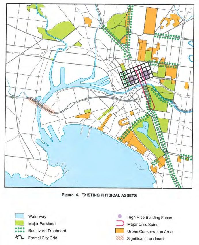
Figure 12: 1984 plan identifies elements of inner Melbourne
Source: 1984 Central Melbourne: Framework for the Future, State Government of Victoria
29M A N AG I N G M E L B O U R N E : R E V I E W O F M E L B O U R N E M E T RO P O L I TA N S T R AT E G I C P L A N N I N G
The 1994 Creating Prosperity: Victoria’s Capital City Policy built on the Central Melbourne
Framework and introduced a number of the projects and ideas that have transformed Central
Melbourne in last 20 years or so, including:
• demolishing the Gas and Fuel buildings and building Federation Square,
• building the Melbourne Exhibition Centre at Southbank,
• completing the Melbourne Casino,
• extending the National Tennis Centre,
• commencing redevelopment of Docklands,
• building a new museum in Carlton,
• expanding the Postcode 3000 project to encourage central city residential development,
• providing new housing in the Docklands and at Lynch’s Bridge,
• restoring the Old Customs House (now the Immigration Museum),
• restoring the Regent Theatre and opening it to the public, and
• creating new open space in the redevelopment of the Jolimont Rail yards (Birrarung Marr).
Perhaps the most surprising lesson from a review of previous planning strategies is how effective
government investment was at transforming inner Melbourne, leaving a lasting legacy and
helping Melbourne maintain its reputation for liveability, even if the larger scale projects such
as Docklands are yet to win public praise.
Urban renewal projects have been successful where they have been part of a broader
strategy of urban regeneration, and created an attractive public realm.
Figure 13: From 1984 plan to reality, Southbank
Source: 1994 Central Melbourne: Framework for the Future and Photo by author
30M A N AG I N G M E L B O U R N E : R E V I E W O F M E L B O U R N E M E T RO P O L I TA N S T R AT E G I C P L A N N I N G
3.8 Height, heritage and character
Height and character probably account for most of the dispute in planning matters.
Historically part of the community concern with high rise development related not just to its
height, but to the demolition of heritage buildings, particularly in the CBD, and the design of
buildings that ignored their context.
Today heritage is protected, and though there is the occasional controversy, there is nothing
like the wholesale destruction of heritage fabric Melbourne witnessed in the 1960s and 1970s.
The 1980 development guidelines for the City of Melbourne provide an insight into the concerns
over the form of development proposed at the time. Concerns included setbacks of buildings
from the street without active frontages and design that did not recognise its context.
Before the mid 1950 height controls were introduced as part of building safety concerns; fire
ladders only reached so far and this set a 40 metre limit for the city. With changes in technology,
building could be taller and the 1958 ACI House on the corner of Albert and Nicholson Street, at
20 storeys, broke through the previous limits.
In the suburbs land was cheap and the additional costs of building a second storey were relatively
expensive. A housing stock of single storey development developed and some councils, even into
the mid 1990s had ‘policies’ against two-storey development.
None of the previous strategies established a systematic approach to height limits across
Melbourne.
Managing issues of height and character is an ongoing challenge.
31M A N AG I N G M E L B O U R N E : R E V I E W O F M E L B O U R N E M E T RO P O L I TA N S T R AT E G I C P L A N N I N G
3.9 Transport investments
3.9.1 Roads and freeways
Metropolitan strategies since 1954 have identified the need for a freeway network and proposed
routes. The network identified in 1969 has endured (with some of the more controversial inner
urban freeways removed) and has been gradually implemented. There has been no similar
enduring plan for public transport.
Figure 14: 1969 plan for freeways (green) and rail (red)
Source: 1969 Melbourne Transportation Study
The construction of freeways was not without controversy and the opening of the Eastern
Freeway (the F19) was met with public protest and during November 1977 protesters blockaded
the opening of the freeway into Alexandra Parade in Collingwood.
Despite the controversy, where reservations have been included in the planning scheme they
have made subsequent construction possible. The lesson from this may be that a long term plan
(rather than a list of capital projects) has the ability to endure and shape urban form over many
decades.
32M A N AG I N G M E L B O U R N E : R E V I E W O F M E L B O U R N E M E T RO P O L I TA N S T R AT E G I C P L A N N I N G
Figure 15: From reservation to reality: 1968 reservation to constructed freeway
Source: www.land.vic.gov.au
A long term plan based around maintaining opportunities for future transport projects, that
can be realised when needed, can have great success.
3.9.2 Rail, Trams and Buses
Melbourne rail network was established early in the settlement of Victoria and Melbourne.
The 1969 Melbourne Transportation Study recommended a number of rail improvements
including the City Loop.
Funding of the project was through debentures, with the State Government paying 60 per cent of
the cost, while a special city levy from 1963 was to fund the remainder. The levy was to last for 53
years, but was ended in 1995. Tunneling works under the city streets commenced in June 1972,
and the Loop was opened gradually between 1981 and 1985.
The 1980 Victorian Transport Study (the Lonie Report), studied freight and passenger transport
within Victoria. This plan recommended the closing of a number of train and tram lines. The effort
in public transport planning and community interest in the 1980s was about keeping services
open; there was no sense that patronage might increase to the degree that new services would
be needed.
Melbourne 2030 proposed a number of network improvements, and a number of transport plans
flowed from Melbourne 2030:
• Managing Our Transport Choices,
• Linking Melbourne Metropolitan Transport Plan:
- Smart buses (similar in concept to the 1988 Met Plan),
- Third track between Dandenong and Caulfield,
- Redevelopment of North Melbourne Station,
33M A N AG I N G M E L B O U R N E : R E V I E W O F M E L B O U R N E M E T RO P O L I TA N S T R AT E G I C P L A N N I N G
- Signalling and track improvements to overcome capacity constraints,
- Construction of Eastlink.
The 2008 Victorian Transport Plan proposed an ambitious program of works. It is fair to say
that none of these plans sets out an ultimate vision for the public transport network in the same
way that the 1969 plan set out a vision for the freeway network. The 2008 plan introduced the
significant proposal to change Melbourne’s rail system into a Metro-style system.
The current State Planning Policy Framework (SPPF) identifies the ‘Principal Public Transport
Network’, a concept articulated in Melbourne 2030. The policies in the SPPF do not distinguish
between actual services and proposed services and so do not distinguish between the levels of
service or connectivity of the routes it identifies (or for that matter whether there is a current
service). The policies treat an outer suburban road with a 20 minute bus service that stops at 7
pm as the same as St Kilda Road, one of the busiest tram routes in the world.
Public transport plans have been weak in identifying areas that are well served by public
transport, and at identifying a long term public transport vision.
Proposals to covert Melbourne’s rail system into a Metro style system is a significant recent
change in thinking.
3.9.3 Bikes and walking
While bikes and walking have featured as part of open space planning their role as an everyday
transport mode has been more recent with the gradual improvement of bicycle facilities,
particularly in the inner suburbs. In the late 1980s a bicycle commuter trip down Canning Street
could be made without seeing another cyclist; this is hardly the case today.
Figure 16: Cycling has grown in popularity
Source: Photo by author
Until 2002, plans did not address bicycles or walking as a transport mode.
Interest in planning for bikes and walking is relatively recent, and physical improvements
have lead to increases in the use of these modes.
34M A N AG I N G M E L B O U R N E : R E V I E W O F M E L B O U R N E M E T RO P O L I TA N S T R AT E G I C P L A N N I N G
3.10 Open space
Planning for open space has been a feature of all plans since 1954. There is an enduring legacy
of identifying, protecting and acquiring regional open space as part of metropolitan strategies.
The 1971 plan, for example, records the proposal for the Dandenong Valley Parklands, a series
of regionally significant reserves extending 10km along the Dandenong Creek from Vermont
South to Wheelers Hill. The Parklands cover an area of 1,306 hectares, and have been
progressively developed as regional open space since the initial reservation of land in 1973.
Not all the parkland has been publicly acquired to date.
A significant change has been the creation of the metropolitan trail network and the
development of waterways as important open space corridors.
In March 1980 The Age newspaper started a campaign for the Lower Yarra River: “Give the Yarra
a go”. The campaign meant two things: give the river its chance by restoring it, and go and try it
for yourself. The campaign was adopted by the government of the day and began the process
of improving the quality of the Yarra River.
The shared path network along waterways and railway reserves dates from the mid 1980s.
Important links were developed in the 1990s with the Inner Circle Railway developed in the
early 1990s as parkland, and the Anniversary Trail along the old outer circle railway line opened
in 1991.
Figure 17: 1954 and 1995 plans for open space.
Source: 1954 plan, 1995 plan
35M A N AG I N G M E L B O U R N E : R E V I E W O F M E L B O U R N E M E T RO P O L I TA N S T R AT E G I C P L A N N I N G
The 1995 plan set out the policy of ‘developing an open space network of parks, trails, bicycle
paths, waterways and habitat corridors throughout the metropolitan region’. This included
proposed open space along the Yarra River upstream from Heidelberg. Much, but not all of this
open space has now been acquired.
The 2002 plan, Melbourne 2030, reinforced past plans and identified new parks:
• Werribee River Regional Park,
• Werribee Township Regional Park,
• Kororoit Creek Regional Park,
• Merri Creek Regional Park,
• Melton Township Regional Park, and
• Cranbourne Regional Park.
There has been an enduring legacy of metropolitan strategies identifying and acquiring new
parkland over time. This is not to play down plan the fact that concern is raised from time to time
about the perceived erosion of existing areas of open space. In inner and middle Melbourne
a number of land fills have been converted to open space, for example at All Nations Park in
Northcote.
Linking People + Spaces, a plan for Melbourne’s open space (2002) identified a ‘Metropolitan
Trails Network’ of 1200 km of shared trails creating a link between Melbourne’s recreational
precincts, open space, public transport and local trails. Currently about 700 km of off-road trails
are complete. This plan informed the regional open space network in Melbourne 2030.
Open space planning has been part of metropolitan planning from the beginning and
Melbourne’s open space network has been gradually expanded and improved, notably with
open space along waterways.
36You can also read