URBAN DESIGN BRIEF 1 Fairview Road East City of Mississauga
←
→
Page content transcription
If your browser does not render page correctly, please read the page content below
1 Fairview Road East
City of Mississauga
URBAN DESIGN BRIEF
11/2020
TABLE OF CONTENTS
                                       Hu
                                         ron
                                            tar
                                               io

                                                                                   Miss
                                                  St

                                                                                       issau
                                                                                            ga V
                                                                                                alley
                                                                              dE

                                                                                                      Blvd
                                                                             R
                                                                          ew
                                                                    ia rvi
                                                                   F
                                   W
                                wy
                              Pk
                               al
                            ntr
                          Ce

                                                               W
                                                            Rd
                                                            iew
                                                         irv
                                                       Fa

                                                                                         C o o ksv i l l e
   Co                                                                                    GO Station
     nfe
        de
          rat
             ion
                   Pk
                     wy
1.0 Introduction   						                    		                1

                2.0 Context Analysis										 3
                   2.1 Subject Property										 4
                   2.2 Planning History										 5
                   2.3 Surrounding Land Uses									 5
                   2.4 Transportation Network								 9

                3.0 Design Vision & Guiding Principles 					                   13
                   3.1 Design Vision									                                  13
                   3.2 Guiding Principles					             		                  14

                4.0 Urban Design Policy 							                                17
                   4.1 City of Mississauga Official Plan            		         18
                   4.2 Downtown Core Built Form Standards 						               24
                   4.3 Hurontario / Main Street Corridor Master Plan						     24

                5.0 The Proposal				         		                                25
                   5.1 Overview		                      		                      26

                6.0 Site Planning & Design Principles		              		        31
                   6.1 Site Organization		                            		  			  32
                   6.2 Pedestrian Circulation and Access		                 			 32
                   6.3 Parking, Loading and Servicing                     			  35
                   6.4 Built Form and Massing                            			   37
                   6.5 Building Facades and Architectural Articulation         46
e                  6.6 Streetscape and Public Realm Design							47
                   6.7 Landscaping and Outdoor Amenity Space		          					47
                   6.8 Wind Impacts											                                 51

                7.0 Conclusion 					                                 		        53
           ve
       st A
   lcre
Hil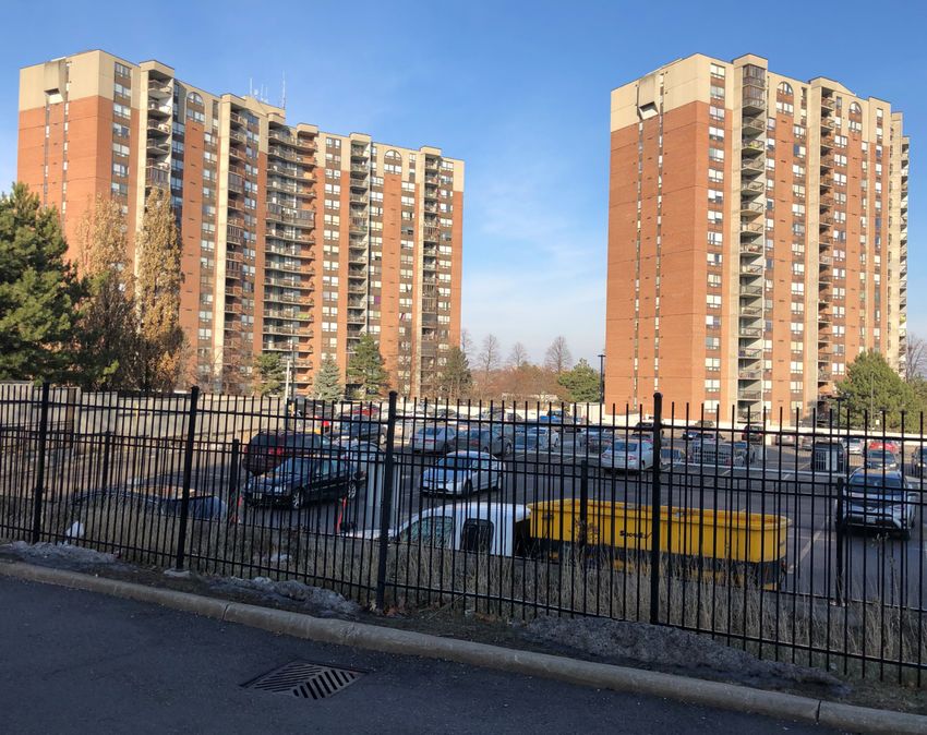
1.0 INTRODUCTION

Figure 1 - Oblique Aerial Image
1 Fairview Road East - Urban Design Brief

This revised Urban Design Brief has been prepared by Sajecki
Planning Inc. to describe the urban design vision, strategy and
rationale for the form and pattern of development proposed
by Edenshaw Fairview Developments Limited for the lands
located at 1 Fairview Road East (“the subject property”) (see
Figure 1).

The Urban Design Brief is a companion document to

                                                                                                              2
the Planning Justification Report to support Official Plan
Amendment (OPA) and Zoning By-law Amendment (ZBA)
applications for the redevelopment of the subject property.
The applications were first submitted in January 2020. This
revised report addresses comments received from the first
circulation.

The proposal is a residential building with at-grade retail
comprising a 34-storey tower, plus mechanical penthouse,
over a 6-storey podium. It is located at the north east corner
of Hurontario Street and Fairview Road East.

This brief is based on the City of Mississauga Terms of
Reference for Urban Design Studies (2019). It includes a
contextual analysis of the subject property and surrounding
area, as well as an overall design framework for the proposed
residential development.

The brief explains how the proposed design achieves key
urban design principles and exemplifies best practice. It
also provides a discussion regarding how the proposed
development complies with the City’s vision for managing
growth through intensification and appropriate built form.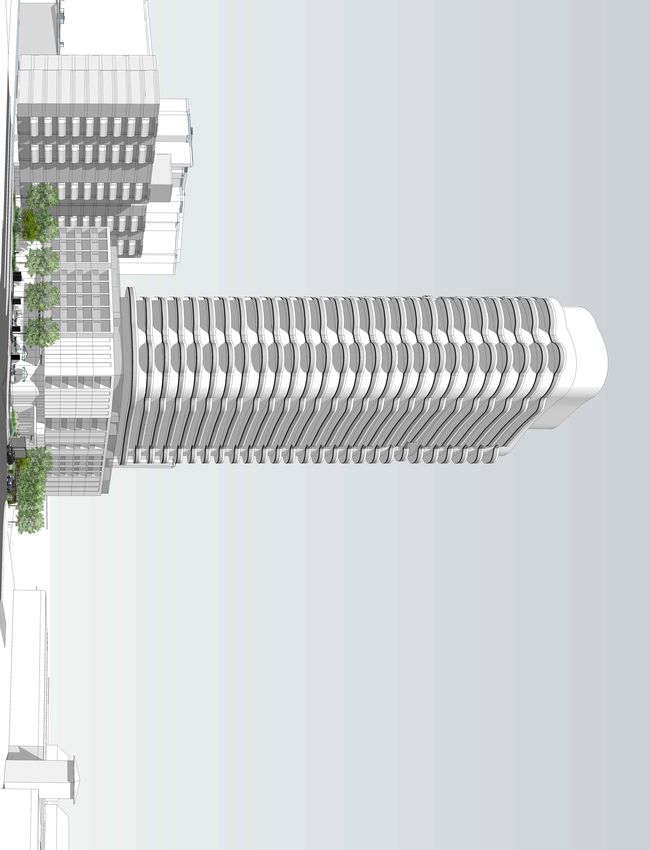
2.0 CONTEXT ANALYSIS
1 Fairview Road East - Urban Design Brief
2.1 Subject Property
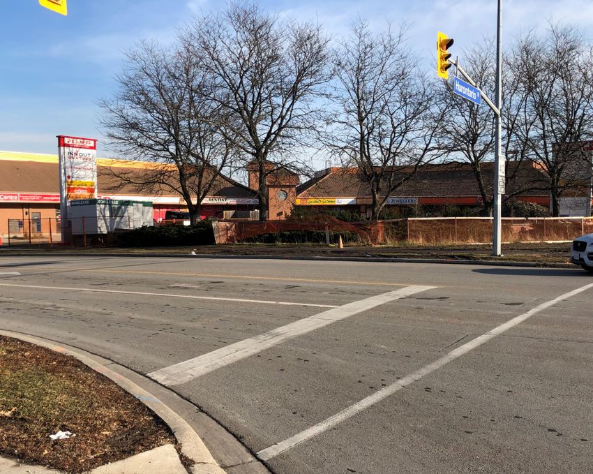
The subject property is located at the north east corner of Hurontario Street and Fairview Road in the City of Mississauga. It is
within the Fairview neighbourhood and Ward 4 boundaries, approximately 600 metres (8-minute walk) north of the Cooksville
GO Station and 300 metres south of a planned LRT stop..
The site is rectangular with a change in grade across the Fairview Road frontage. Total lot area is 0.72 acres (0.29 hectares)
with a frontage of 35.68 metres along Hurontario Street and 55.16 metres along Fairview Road East. The subject property is
4
currently vacant with no existing access points or driveways.
The legal description for the subject property is PL 359 PT LTS 2, 3, RP 43R10450 PTS 3, 4, 7, 8. A shared easement exists
between the subject property and the adjacent property to the east.
Subject Property, 1 Fairview Road East (looking northwest on Fairview)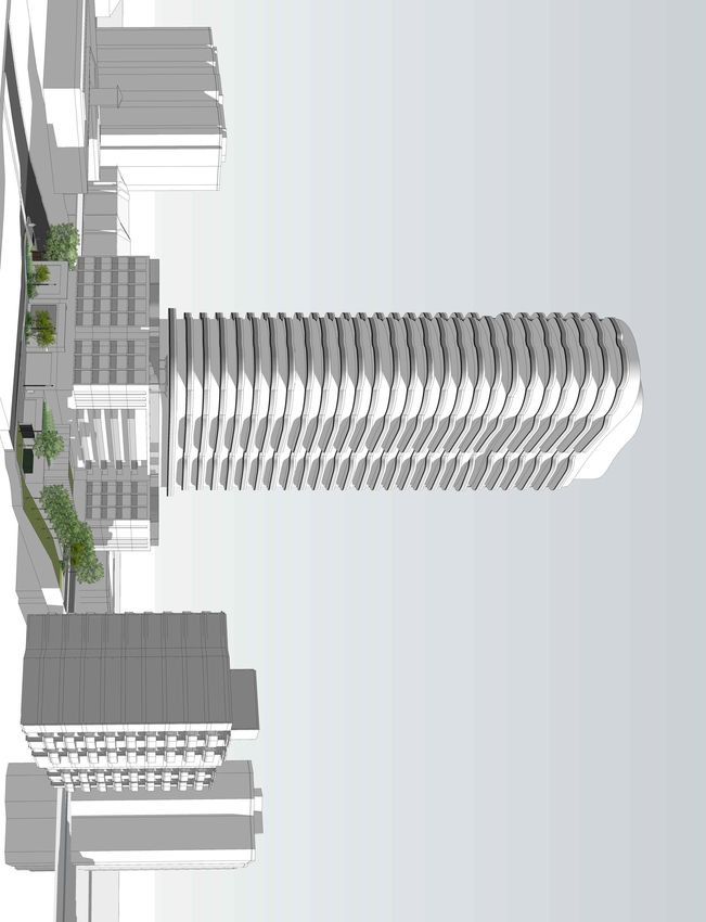
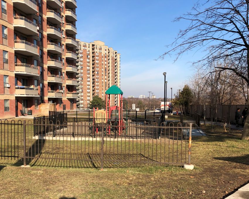
2.2 Planning History                                           East of the subject property are two high-rise apartment
                                                                   buildings approximately 18 to 19 storeys in height. A large
    In 1983, OPA and ZBA applications were approved to facilitate surface parking lot, tennis courts and a children’s playground
    the development of an office building on the subject property surround these buildings.
    (City File No. OZ 83 46). The previous landowners did not
    proceed with completing this proposal. At this time, we are Located on the west side of Hurontario Street is Fire Station
    seeking amendments from the office provisions to re-introduce 101 and a 16-storey residential apartment building. Located at
    permissions for residential uses to facilitate the development the south west corner of the intersection of Hurontario Street
5

    of a 34-storey apartment building with at-grade retail.        and Fairview Road is a 3-storey townhouse development.

    2.3 Surrounding Land Uses

    2.3.1 Immediate Surroundings
    Immediate land uses surrounding the subject property include
    a range of high and mid-rise residential apartment buildings,
    numerous low-rise commercial buildings and a variety of low-
    rise residential properties along internal local roads.

    To the immediate north is a 10-storey residential apartment
    building with surface parking and a children’s play area. This
    building is accessed through a two-way private lane from
    Fairview Road East on the east side of the subject property.
    Further north along Hurontario Street, there is an Esso gas
    station and Tim Hortons.

    On the south side of Fairview Road East is a one-storey, ‘L’
    shaped commercial plaza owned by Kaneff Properties that
    includes a variety of uses such as medical offices, a spa and
    various eating establishments. Surface parking is located
    at the front and rear of the building. Further south is a low-
    rise residential street (Burdock Place) with semi-detached
    dwellings.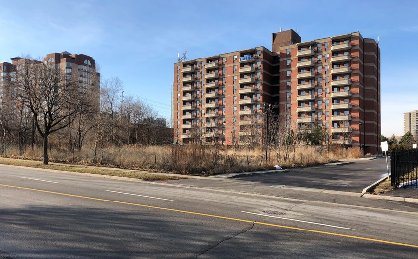
1 Fairview Road East - Urban Design Brief

                                                                                                                                                                             6
10-storey residential apartment building immediately north of the subject property   Children’s play area adjacent to the 10-storey building north of the subject property

Commercial plaza south of the subject property                                       High-rise apartment buildings and parking immediately east of the subject property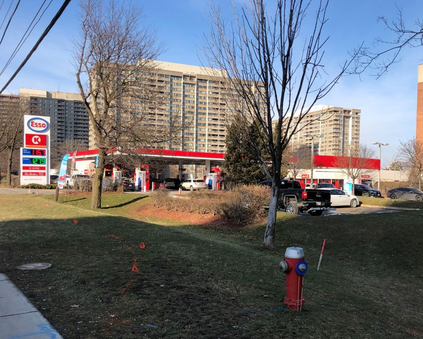
2.3.2 General Surroundings
    North (East & West)
    The area north of Fairview Road consists of high-rise
    residential apartment buildings between Mississauga Valley
    Boulevard to one block west of Hurontario Street. West
    of the Fire Station are low-rise single and semi-detached
7

    dwellings. Building heights increase north of Central Parkway
    as Hurontario Street transitions towards the Downtown Core.

    Additional uses include Fairview Public School and Kariya
    Park located to the north west, the adult education centre and
    Bishop Scalabrini School to the west and Mississauga Valley
    Park and Community Centre to the north east.
                                                                                       31-, 32- and 33-storey residential apartment buildings (looking north on Hurontario St)

    City of Mississauga Fire Station 101 on Hurontario St (west of subject property)   Gas station along the east side of Hurontario St (north of subject property)
South (East & West) The area south of Fairview Road is primarily comprised of low- rise residential buildings in the form of single detached, semi- detached and townhouse units with a strip commercial plaza at the south east corner of Hurontario Street and Fairview Road. South of the rail corridor, the Hurontario Street frontage is primary comprised of low-rise commercial buildings. Other notable locations south of the subject property include Stonebrook Park and Thornwood Public School located to the east and the Cooksville GO Station located to the south west. The general neighbourhood is predominated by residential land uses ranging between low to high-rise buildings. In addition to these residential buildings, numerous commercial Townhome development on the southwest corner of Hurontario St and Fairview Rd properties are located south of the rail corridor and are interspersed throughout the neighbourhood. Residential neighbourhood along Hurontario St, south of the subject property Underpass south on Hurontario St (GO rail line)
2.4 Transportation Network                                   Central Parkway is an east-west two-way road identified in
                                                                 as a Major Collector (Schedule 5 – Long Term Road Network).
    As identified in Schedules One and Two of the City of It is a primary on-road / boulevard cycling route (Schedule
    Mississauga Official Plan (MOP), the subject site is located 7 – Long Term Cycling Route). The ultimate right-of-way
    within the Downtown Intensification Area, specifically increases from 30 metres to 35 metres as it travels east
    Downtown Fairview, and at the congruence of two Major crossing Hurontario Street (Schedule 8 – Designated Right-
    Transit Station Areas (MTSAs) including the Cooksville GO of-Way Widths).
    Mobility Hub. The following sub-sections provide a review of
9

    the immediate road and transit network.                      2.4.2 Transit Network
    2.4.1 Road Network                                                  Bus Services

    Hurontario Street is identified in the MOP as an Intensification    The subject property is well connected to existing and planned
    Corridor (Schedule 1c – Urban System – Corridors), Arterial         public transit services (see Figure 2).
    Road (Schedule 5 – Long Term Road Network) and Higher
                                                                        Bus services along Hurontario Street include the 19
    Order Transit Corridor (Schedule 6 – Long Term Transit
                                                                        Hurontario and 103 Hurontario Express. The proposal is
    Network). Hurontario Street is a two-way north-south arterial
                                                                        also serviced by the 53 Kennedy, 3 Bloor and 304 Father
    road with six lanes and dedicated left-turn lanes in both
                                                                        Goetz-Mississauga Valley routes.
    directions at the intersection of Fairview Road. The existing
    right-of-way will shortly undergo significant changes as            Route 19 is a local route with all week service running north-
    the Hurontario Light Rail Transit (LRT) line is constructed.        south from Highway 407 and Hurontario Park and Ride to
    According to Schedule 6, there is a LRT station proposed in         Lakeshore Road. There are additional 19 routes including
    close proximity to the subject property. The street is identified   19A Hurontario Britannia that runs Monday to Friday between
    as a primary on-road/boulevard cycling route (Schedule 7            Britannia Road and the Trillium Health Centre, 19B Hurontario-
    – Long Term Cycling Routes). The ultimate right-of-way in           Cantay that runs on Saturday’s between Heartland Shopping
    between the rail lines to the south and Central Parkway is 45       Centre and the Trillium Health Centre.
    metres (Schedule 8 – Designated Right of Way Widths).
                                                                        Route 103 is an express route with all week service that
    Fairview Road is identified in the MOP as a Minor Collector         also runs north-south from Brampton Gateway Terminal to
    (Schedule 5 – Long Term Road Network). It is a local, two-way       Lakeshore Road and the Port Credit GO Station.
    road running from Grand Park Drive to Mississauga Valley
                                                                   Route 53 is a local route with Monday to Friday service that
    Boulevard with a 26-metre ultimate right-of-way. There is one
                                                                   runs north-south from Highway 407 and Hurontario Park &
    lane in each direction with dedicated left-turn lanes at major
                                                                   Ride to Fairview Road East. Route 3 is a local route with all
    intersections, including Hurontario Street.
                                                                   week service that runs east-west from City Centre Terminal
1 Fairview Road East - Urban Design Brief
10
SUBJECT
PROPERTY
Figure 2 - Transit Mapto the Kipling and Islington TTC stations. Route 304 is a local Hurontario LRT Line will run 18 km north-south from the
school route with Monday to Friday service on school days Brampton Gateway Terminal to the Port Credit GO Station.
only effective September to June 2019. It runs a loop around There will be a total of 19 stops with the LRT running in its own
Mississauga Valley Boulevard and travels along Central dedicated right-of-way. There are two stops in proximity to the
Parkway in the morning and Fairview Road in the afternoon subject property including one at the Cooksville GO Station
providing a bus route for the Father Michale Goetz Secondary and another at the corner of Hurontario Street and Central
School. Parkway. Completion is anticipated for 2022.
11
There is a bus stop located in each of the four corners at the Located on the Hurontario LRT Line, the Fairview LRT
Hurontario and Fairview intersection. In addition, there is a Station on Central Parkway is located within a 300 m walking
bus stop located at the south west corner of Fairview Road distance from the subject property.
East and Burdock Place and two bus stops at the intersection
of Fairview Road East and Mississauga Valley Boulevard.
Train and Bus Rapid Transit Services
Cooksville GO Station is located on the east side of
Hurontario Street approximately 600 metres south of the
subject property. This station forms part of the Milton line that
travels east-west between the Milton GO Station and Union
Station in Downtown Toronto.
The subject property is connected to the GO Station via the
Route 19 bus service.
Major improvements are underway at the GO Station including
a new parking structure with pedestrian bridge connecting to
the rail platforms, station building, tunnels and a new entrance
from Hurontario Street. It is anticipated construction will be
complete by the end of 2020.1 Fairview Road East - Urban Design Brief
123.0 DESIGN VISION & GUIDING PRINCIPLES
1 Fairview Road East - Urban Design Brief

3.1 Design Vision                                             3.2 Guiding Principles
A well-designed building helps to support a sustainable urban Design Excellence
form. High quality urban design leads to a strong sense of
                                                                  • Create a sense of gateway for the Downtown Fairview
place that is vibrant, attractive, livable and functional. Higher
                                                                    Character Area through prominent built form and
density buildings should be organized along Intensification
                                                                    landscaping, identifying a focal point between the
Areas where supportive infrastructure exists or is planned.
                                                                    Downtown Core and Downtown Cooksville Character

                                                                                                                              14
1 Fairview Road East is located along an Intensification Area       Areas (MOP 9.2.1.28; 9.3.3.1); and
within the Downtown, specifically the Downtown Fairview
                                                                  • Employ high-quality architectural design and materials
Character Area and Hurontario Corridor (Schedules 1,
                                                                    in all aspects of building design, contributing to and
1b and 2 of the MOP). It is located directly adjacent to the
                                                                    enhancing the Mississauga skyline (MOP 9.2.1.12;
planned Hurontario LRT and within two MTSAs, including the
                                                                    9.3.3.2; 9.5.2.1).
Cooksville GO Mobility Hub. The design of 1 Fairview Road
East will prioritize high-quality urban design and architectural Respect the Experience, Identity and Character of the
standards. It will include a mix of uses and support a multi- Surrounding Context (9.1, Section 9 MOP)
modal transportation system, specifically encouraging the use
of public transit and active transportation.                      • Enhance the Hurontario Corridor and provide appropriate
                                                                    transitions to neighbouring properties (MOP 9.1.5);
1 Fairview Road East is proposed as a 28 storey tower above
a 6 storey podium. The proposal incorporates an active retail • Provide building massing and heights that do not cause
space at grade along Hurontario Street and four integrated          inappropriate shadow impacts on adjacent properties
townhouse units with direct access to the sidewalk along            (MOP 9.2.2.4d); and
Fairview Road East. At grade uses include double height retail, • Respond to the area’s existing and emerging urban
indoor amenities including a coworking space, a residential         context (MOP 9.1.10c).
lobby and four two-storey residential town units. The proposal
aids in establishing strong architectural character to help Frame an Active Public Realm and Pedestrian
define the intersection of Hurontario Street and Fairview Road. Environment

The vision for 1 Fairview is expressed through the following •     Address pedestrian scale through building articulation,
guiding principles, which are based on the urban policies          massing and materials (MOP 9.2.1.16);
included in Chapter 9 - Build a Desirable Urban Form, and are •    Ensure a high design standard between the public realm
additionally informed by policies in Chapter 12 - Downtown         and the development interface (MOP 9.2.1.20);
(Urban Design Policies 12.4.1) and the Downtown Local Area
Plan of the MOP (Urban Design Components Section 3.2), in •        Create a sense of place and civic pride (MOP 9.1.8); and
addition to the City’s Downtown Core Built Form Standards.
                                                              •    Provide eyes on the street through active and animated
building frontages (MOP 9.4.1.3).
Support Public Transit and Active Transportation
• Foster the improvement of connections, comfort and
accessibility for transit users and promote active
transportation modes (MOP 9.4.1); and
• Promote a diverse mix of uses and residential suite type
15
(MOP 9.1.2).
Require Properties to Develop in a Manner that
Contributes to the Overall Vision for the City
• Develop an urban form based on the urban system and
the hierarchy identified in the city structure as shown on
Schedule 1: Urban System of the MOP (9.1.1).1 Fairview Road East - Urban Design Brief
164.0 URBAN DESIGN POLICY
1 Fairview Road East - Urban Design Brief

4.1 City of Mississauga Official Plan                               Section 5.3 sets out the City Structure, which organizes the city
                                                                    into functional areas to establish the framework for planning
Section 1.12 of the MOP describes the purpose of the Official policies that will guide development. The City Structure is
Plan. It states that the Official Plan provides policies to manage comprised of a number of elements including Downtown; Major
and direct the physical change of the city and the effects of Nodes; Community Nodes; Corporate Centres; Neighbourhoods;
such change on the social, economic, cultural and natural Employment Areas; and Special Purpose Areas. Also, within this
environments. It also forms the basis for detailed land use section of the MOP, height and density permissions for each of
designations and urban design policies and sets the context the City Structure elements are set out. Within the Downtown,

                                                                                                                                           18
for the review and approval of development applications.            no maximum height is specified while the minimum height is 3
                                                                    storeys. The density target is 300 to 400 combined residents and
Growth Management Policies                                          jobs per gross hectare by 2031 with a minimum gross density
                                                                    required of 200 residents and jobs.
Schedule 1 – Urban System identifies the three distinct, yet
interconnected, components that comprise the structural Section 5.3.1 sets out the general polices for the Downtown. The
framework for the city. These include the Green System, City Official Plan states that the Downtown represents a unique area
Structure and Corridors. The subject property is not located within within the City Structure and that much of the city’s new population
the Green System. It is located within the Downtown element of and employment growth will locate in the Downtown.
the City Structure and within an Intensification Corridor.
                                                                    Policy 5.3.1.1 identifies the Downtown as comprised of the lands
Schedule 2 – Intensification Areas locates the subject property at along Hurontario Street between Highway 403 and the Queen
the intersection of two MTSAS. Schedule 6 – Long Term Transit Elizabeth Way while policy 5.3.1.2 divides the Downtown into four
Network identifies the subject property as located along a Higher Character Areas with the subject property located within THE
Order Transit Corridor and within close proximity of a Light Rail Downtown Fairview Character Area (see Figure 5).
Transit (LRT) Station (see Figure 3). Schedule 7 – Long Term
Cycling Routes identifies Hurontario Street as a location for a Policy 5.3.1.11 provides that development in the Downtown will
Primary On-Road / Boulevard Route. Schedule 9 - Character be in a form and density that achieves a high-quality urban
Areas situates the subject property within the Downtown Fairview environment.
Character Area and Schedule 10 – Land Use Designations               Section 5.4 of the MOP addresses Corridors. Corridors are
designates the property Office (see Figure 4). The accompanying      important elements of the public realm, as they link communities
Planning Justification Report discusses the unique details behind    and are locations where people experience the city on a day-to-
this existing land use designation.                                  day basis. Policy 5.4.3 states that Corridors that run or abut the
Section 5.0: Direct Growth                                           Downtown are encouraged to develop with a mix of uses oriented
                                                                     towards the Corridor. According to Policy 5.4.7 land uses and
Section 5 of the MOP sets out the general growth management          building entrances will be oriented to the Corridor where possible.
framework and describes the Urban System that will be used
for determining where population and employment growth will Section 5.5 Intensification Areas directs that future growth will
be encouraged as well as areas that are expected to remain primarily be directed to Intensification Areas with the focus for
relatively stable.                                          intensification located within the Downtown, Intensification
Corridors and MTSAs along with Major Nodes, Community Nodes of the built environment will be critical for achieving the vision for
and Corporate Centres (Policy 5.5.1). Policy 5.5.5 states that Intensification Areas as vibrant, mixed use areas, serviced by
development will promote the qualities of complete communities multi-modal transportation.
and policy 5.5.8 states that residential and employment density
Policies 9.2.1.1 to 9.2.1.4 provide direction with regards to
should be sufficiently high to support transit usage. Pedestrian
buildings creating a sense of place. New development should:
movement and access from transit routes will be a priority in
Intensification Areas.
• Create distinctive places and locales;
19
Section 9.0: Build a Desirable Urban Form
• Provide the creation of a sense of place through distinctive
Section 9 outlines the built form and urban design policies that architecture, streetscaping, public art and cultural heritage
recognition; and
assist in creating a “strong sense of place.” These policies are
intended to facilitate development that respects the experience, • Encourage a high quality, compact and urban built form
identity and character of the surrounding context; ensures to reduce the impact of extensive parking areas, enhance
pedestrian circulation, complement adjacent uses, and
the sustainability of natural systems and urban living; protects distinguish the significance of the Intensification Areas from
the quality of life of residents, employees and visitors; ensure surrounding areas.
the connectivity and integration of surrounding uses; and that
contributes to the overall vision for the city. Policies 9.2.1.11 through 9.2.1.16 provide specific requirements for
tall buildings. Tall buildings should:
Downtown
• Be sited and designed to enhance an area’s skyline while
Within Intensification Areas an urban form that promotes a preserving, reinforcing and defining view corridors;
diverse mix of uses and supports transit and active transportation
modes will be required (Policy 9.1.2). Policy 9.1.10 states that • Provide appropriate tower separation distance to minimize
the city vision will be supported by site development that: shadow impacts and provide privacy;
• Incorporate podiums in appropriate locations, and utilize
• Respects the urban hierarchy; building articulation, massing and materials to address
• Utilizes best sustainable practices; pedestrian scale and mitigate wind and shadow impacts; and
• Demonstrates context sensitivity, including the public realm;
• Minimize adverse microclimatic impacts on the public realm
• Promotes universal accessibility and public safety; and and private amenity areas.
• Employs design excellence.
Section 9.3 and 9.4 provide direction for how new buildings relate
Intensification Areas to the public realm and support transit and active transportation
Section 9.2.1 of the MOP discusses policies for Intensification respectively. Buildings are to be designed to foster the
Areas including the Downtown, Intensification Corridors and improvement of connections and accessibility for transit users
MTSAs. It identifies that Intensification Areas are expected to and promote active transportation modes as well as vehicular and
exhibit high standards of urban design. Further, the physical goods movement. These elements are all impacted by how the
form, relationship among buildings and spaces and the quality development is configured.1 Fairview Road East - Urban Design Brief
Site Development and Buildings
Policies within Section 9.5 of the MOP provide guidance with
respect to how buildings should relate to their context including
the arrangement of building elements; the relationship between
the building and the public realm; the design of parking, servicing
and loading areas; and site layout principles to promote safety.
20
Building facades should be articulated through variations in
materials or material treatments. Street facades should have the
highest design quality and buildings should be pedestrian oriented
through the design and composition of their facades, including
their scale, proportion, rhythms, continuity, texture, detailing and
materials. Further, developments should enhance public streets
by creating a desirable street edge condition.
Section 12: Downtown
Policies in Section 12 provide specific requirements for
development located within the Downtown. The Downtown
includes four Character Areas: Downtown Core, Downtown
Fairview, Downtown Cooksville, and Downtown Hospital. The
subject property is located within the Downtown Fairview
Character Area. Section 12.3 provides specific urban design
policies for developments within the Downtown Fairview
Character Area, none of which apply to the subject property.21
Figure 3 - Schedule 6 - Long Term Transit Network, City of Mississauga Official Plan1 Fairview Road East - Urban Design Brief
22
Figure 4 - Schedule 10 - Land Use Designations, City of Mississauga Official Plan23
Figure 5 - Map 12-3: Downtown Fairview Character Area, City of Mississauga Official Plan1 Fairview Road East - Urban Design Brief
4.2 Downtown Core Built Form Standards 4.3 Hurontario / Main Street Corridor Master Plan
The Downtown Core Built Form Standards (DCBFS) provide The Master Plan outlines the vision for the Hurontario Street corridor
urban design direction and guidance for proposed development in including mixed-use, compact transit-oriented developments, with
order to assess, promote and fulfill the intent of the City’s Official
varying heights and densities based on the character of existing
Plan, policies, Downtown21 vision and Zoning By-law 0225-2007. adjacent communities. The vision for the Downtown Fairview
Character Area is to be developed as a complete downtown
Although these guidelines do not specifically pertain to the with a mix of high density uses, predominantly comprised of
24
Downtown Fairview Character Area the tall building guidelines residential uses with retail encourage at-grade. Permitted heights
are indicative of built form considerations in an intensification and densities for this area identify maximums of 25 storeys and
area. The Standards set out detailed requirements to achieve a 4.0 FSIs.
high quality built form in the Downtown Core that interfaces with
the public realm in a seamless fashion.
The document is divided into sections covering frontage
standards; design standards; and tall building standards such
as massing, podium design, tower design, site orientation and
compatibility and transition to adjacent areas.
A few key guidelines include:
• Podiums will be articulated to maximize sunlight on the
public realm and mitigate effects of wind on the pedestrian
environment.;
• Point towers should be located on the north-west and south-
west sides of a block so that shadows fall primarily within the
block itself;
• Tower floor plates above the podium height will not exceed
a maximum area of 850m 2 (inclusive of core, servicing and
circulation components); and
• There should be a minimum 30 m separation distance
between towers.
A detailed review of the DCBFS against the proposal is provided
in Section 6 of this report.5.0 THE PROPOSAL
1 Fairview Road East - Urban Design Brief

The development proposal consists of a 28 storey tower         of indoor amenity space and 662.32 square metres of outdoor
and 6 storey podium with retail space along the Hurontario     amenity space. This results in 1,267.12 square metres of
Street frontage, and the residential lobby and four integral   indoor amenity space and 739.64 square metres of outdoor
grade-related townhouse dwellings along the Fairview Road      amenity space for a total of 2,006.76 square metres of total
East frontage. The total proposed unit count is 434 units      amenity area or 4.60 square metres / unit.
comprised of 31 studio (seven percent), 304 one bedroom and
one bedroom plus den units (70 percent) and 99 two bedroom     Bicycle and vehicular parking are both accessed via a shared
                                                               laneway along the north-east side of the subject property.

                                                                                                                                   26
and two bedroom plus den units (23 percent). The site area
is 2,902.17 square metres with a proposed retail gross floor   The shared laneway is accessed from Fairview Road East.
area (GFA) of 272.90 square metres and proposed residential    The visitor bike parking room is located at grade and is directly
GFA of 28,660.10 square metres for a total project GFA of      accessible to the residential lobby. Long term bike parking
28,933.00 square metres. This results in a Floor Space Index   will be underground, with specific locations to be indicated at
(FSI) of 9.97. The maximum building height is 109.1 metres     a future date. Additionally, several bike parking spaces are
exclusive of mechanical penthouse.                             provided outdoors on the north-east corner or the site, along
                                                               Hurontario Street.
The podium is setback a minimum of 3.0 metres from the
property line along Hurontario Street, 2.2 metres from Fairview The proposal includes 374 residential parking spaces and 65
Road East, 4.5 metres from the property to the north and 6.5 visitor/commercial spaces for a total of 439 vehicular parking
metres from the property to the north east.                     spaces over 8.5 levels of underground parking.

Along the Fairview Road East frontage, four street-related A table of key site statistics are included in Table 1 - see page
townhouse dwellings are proposed. These units provide 27.
a direct pedestrian connection between the proposed
development and the street encouraging an active private and
public realm. Active at-grade uses are also provided along
Hurontario with direct access to at-grade retail uses and the
residential lobby. Aside from access to the residential lobby,
the entire Hurontario frontage is comprised of retail space.

Indoor and outdoor amenity spaces are provided on the first
and second levels of the podium and on the seventh floor.
Grade related amenity space includes 404.79 square metres
of indoor amenity space and 77.32 square metres of outdoor
amenity space. The second floor includes 189.18 square
metres of indoor amenity space. And the seventh floor is
entirely devoted to amenity space with 673.15 square metres
1. SITE AREA 2,902.17 SQ.M / 31,238.70 SQ.FT
2. GROSS FLOOR AREA 28,933.10 SQ.M / 311,494.74 SQ.FT
3. DENSITY FSI = 9.97
27
4. HEIGHT 34 STOREYS @ 109.1 M + MECH PH = 115.1 M
5. TOWER FLOORPLATE 848.17 SQ.M
6. TOWER SEPARATION 40.875 M TO ADJACENT BUILDING
7. NO. OF RESIDENTIAL UNITS 434 UNITS
(31 STUDIO, 304 ONE-BED AND ONE-BED PLUS DEN, AND 99 TWO-BED AND TWO-BED PLUS DEN)
8. RETAIL AREA 272.90 SQ. M / 2,937.47 SQ. FT
9. INTERIOR AMENITY SPACE 1,267.38 SQ. M
10. EXTERIOR AMENITY SPACE 739.64 SQ. M
11. PARKING 65 VISITOR + 374 RESIDENT = 439 TOTAL SPOTS
(0.15/UNIT VISITOR | 0.86/UNIT RESIDENT | 1.01/UNIT TOTAL)
1 Fairview East Statistics1 Fairview Road East - Urban Design Brief
28
Development Rendering, 1 Fairview Rd EDR
A000
A001
A002
A010
A100
A201
A202
A203
A204
A205
A206
A400
A401
A500
A501
A502
A503
29
1 ISSU
NO. REV
"ALL DR
ARE THE
BE RETU
SPECIFI
IS FORB
PERMISS
CONTRA
JOB.
Development Rendering, Podium
1 FAIRVIEW
CHECK SET
15 SEPTEMBER 2020
DRAWN
G.S.
CHECKED
G.S.
TITLE
TITL
PROJECT
19-1721 Fairview Road East - Urban Design Brief
30
VIEW LOOKING
Development WEST
Rendering, Townhouse UnitsALONG FAIRVIEW
and Vehicular ROAD
Access (along Fairview Rd E) VIEW LO6.0 SITE PLANNING & DESIGN PRINCIPLES
1 Fairview Road East - Urban Design Brief

6.1 Site Organization                                                   6.2 Pedestrian Circulation and Access
The proposal includes active frontages along both Hurontario       Pedestrian access to the retail space along Hurontario is directly
Street and Fairview Road East (see Figure 6).                      accessible from the sidewalk. The retail entrance is located under
                                                                   a covered weather protected canopy. Similarly, pedestrian access
Along Hurontario Street the frontage is comprised of retail space. to the residential lobby is directly accessible through a vestibule
The podium setback varies along Hurontario and includes space to public sidewalks from both Hurontario Street and Fairview
for an outdoor patio. The Fairview Road East frontage is animated Road East. From Hurontario Street access is provided via a 9.1 m

                                                                                                                                         32
by the residential lobby, landscaping and four integral grade sloped walkway and from Fairview Road East access is provided
related townhouse dwellings with outdoor patios and individual from the sidewalk via a staircase.
direct access to the sidewalk.
                                                                   Street-related access to the individual townhouse units are also
Vehicular access to parking, loading and servicing is restricted provided along Fairview Road East, directly from the public
to a shared laneway within the north-east portion of the site sidewalk. Access to the townhouse units mimics the grade
supporting a strong pedestrian streetscape along both public change along Fairview with this change mitigated via retaining
street frontages. A total of 439 parking spaces are provided over walls and landscaping and requiring approximately four to five
eight and a half underground parking levels. One type ‘G’ loading steps to reach each unit. All proposed pedestrian access points
space is located at grade interior to the building and concealed to retail, townhouse units and the residential building are close to
by indoor amenity space and the garbage room. Secure interior existing transit stops and the planned Hurontario LRT.
residential short-term bicycle parking is located between the
townhome units and the garbage room. It has direct access to As part of the reconstruction of Hurontario Street the planned
both the residential lobby and the rear laneway.                   right-of-way includes physically separated on-street bike lanes.
                                                                   Unobstructed access to short-term bicycle parking is provided via
Indoor and outdoor amenity spaces are proposed on the first, the shared laneway off Fairview (see Figure 7).
second and seventh floors. Ground floor indoor amenity space
totals 463.10 square metres while ground floor outdoor amenity Since the first submission in January 2020, design changes
space totals 77.32 square metres. Indoor amenity space is have been made to improve overall wind conditions. These
accessed from the residential lobby while outdoor amenity space include increasing setbacks and reducing the overall height of
can be accessed from the indoor amenity space. Second floor the proposed building. Based on the findings from the revised
amenity space is all interior. It comprises a business centre / Pedestrian Wind Study, it can be concluded that the proposed
work from home area and is 189.18 square metres. Seventh floor development is not anticipated to have a negative impact on
amenity space includes 615.10 square metres of indoor space wind conditions on and around the project site. Wind speeds are
and 662.32 square metres of outdoor space. This results in total anticipated to remain suitable for the intended usage throughout
amenity space of 2,007.02 square metres (4.60 m2 / unit).          the year at all assessed grade and above-grade areas.

A retail space of 272.90 square metres bring active uses and
eyes on the street to the Hurontario Street frontage. This is further
emphasized by its adjacency and seamless connectivity to the
planned Hurontario LRT.
VEHICLE
PARKING
13000
LOADING
BICYCLE (FAIRVIEW ROAD WIDENING)
PARKING
SETBACK
6500
K
SETBAC
14450
6
1 LINE DENOTES FACE
OF BUILDING ENVELOPE
33
TOWNHOUSE
GREEN ACCESS
ROOF
TOWNHOUSE
ACCESS
1
CENTRE LINE OF FAIRVIEW ROAD (CENTRE LINE TAKEN FROM SURVEY PREPARED ON 31 JULY 2020 BY R. AVIS SURVEYING INC.)
TOWNHOUSE
ACCESS
4500
SETBACK
3000
GREEN TOWNHOUSE
ROOF ACCESS
34 STOREY 2200
SETBACK
TOWER
4500
SETBACK (850m2)
FAIRVIEW ROAD EAST
15600
2
SETBACK RESIDENTIAL
ACCESS
40875 3000
7500
SETBACK
3000
6
SETBACK
RETAIL
ACCESS
3000
HURONTA
RIO STREE
T
Figure 6 - Site Plan (A100)1 Fairview Road East - Urban Design Brief
EX. TREE TO BE RETAINED
(REFER TO ARBORIST REPORT
AND PLAN)
TREE PROTECTION FENCING
(REFER TO ARBORIST REPORT EX. WALKWAY CONNECTION EX. TREES TO BE RETAINED
AND PLAN) TO ADJACENT PROPERTY TO (REFER TO ARBORIST REPORT
REPLACEMENT TREE 2.4m HT. LANDSCAPE WALL SHRUB AND BE MAINTAINED AND PLAN)
G
C
D
H
A
B
E
F
J
PLANTING ON ADJACENT AROUND OUTDOOR AMENITY ORNAMENTAL
PROPERTY SPACE TREE BUFFER TREE PROTECTION FENCING
PLANTING (REFER TO ARBORIST REPORT
6300 6300 6300 6300 6300 6300 6300 6300
AND PLAN)
TPZ TPZ TPZ
OUTDOOR AMENITY
EDGE OF U/G EDGE OF U/G
TRANSFORMER
AD1 AD2
832.29 ft²
136.15
LINE OF BELOW
77.32 m²
EXHAUST VENT - LANDSCAPE BUFFER
YOGA
LANDSCAPE GRADE PARKING OUTDOOR TRANSFORMER
PAD
REFER TO ARCH. BUFFER AMENITY SPACE SOD
PAD
HURONTA
1
TRANSFORMER SETBACK
FITNESS STUDIO 2.0m HT. WIND SCREEN -
6300
DETAILS TO BE
YOGA /
DETERMINED IN
EDGE OF U/G
ELECTRICAL
ALECTRA
CONJUNCTION WITH
34
WIND SCREEN
ROOM
2.0m HIGH
COVERED DOWNRAMP WIND CONSULTANT
136.15
132.36
133.86
134.08
MACHINES
WEIGHTS
RAMP DOWN RAMP DOWN
WEIGHT
TO U/G GARAGE -
FREE
24.0m @ 15.0% 3m @ 7.5%
AD3
2
REFER TO ARCH.
CHANGEROOM
INDOOR AMENITY
WOMEN'S
6300
4,357.14 ft²
404.79 m²
136.15
(GYM)
RIO STREE
133.90
DN
10
BIKE RACKS
AD9
3
133.75
PROPERTY LINE
EDGE OF U/G
UP
STAGING AREA
13
894.75 ft²
WATER / TOWELS
133.75
83.13 m²
133.75
TYPE "G" LOADING
7000
UP DN UPGRADED PAVING AT
2,926.75 ft²
4m @ 7.5%
6300
RAMP UP
(4.0m X 13m X 6.1m HIGH)
MOVING ROOM
271.90 m²
136.15
RETAIL
AD4 RAMP AND LOADING
133.75
ENTRANCES
1.5m HT. WIND SCREENS - DETAILS TO BE DETERMINED RETAIL GARBAGE
IN CONJUNCTION WITH WIND CONSULTANT (TYP. OF 4 11875 WALKWAY CROSSES
ALONG HURONTARIO FRONTAGE) OVER RAMP AND
SCISSOR
LIFT
4
PROPOSED PAVING EXTENDS TO EDGE OF LRT LOADING ENTRANCES -
DN
HEAVY-DUTY CONCRETE
AD8 STREETSCAPE WORKS
G
G
G
G
G
G
GARBAGE ROOM
F/A
WIND SCREENS
1,157.32 ft²
EX. SHARED
107.52 m²
1.5m HIGH
133.75
G
LANEWAY TO
T
6300
CHANGEROOM
REMAIN
136.15
MEN'S
CACF
R
R
R
R
R
R
R
UNCOMPACTED
OUTLINE OF BUILDING CANOPY ABOVE - REFER
GARBAGE
INTAKE
R
SHAFT
TO ARCH.
5
EDGE OF U/G
+ 136.20
RESIDENTIAL SHORT-TERM
DN
12
BICYCLE PARKING
POTENTIAL RETAIL PATIO STAFF /
DN
DN
DN
DN
5
3
3
3
133.85
6300
(CONCEPTUAL ONLY - ACTUAL FURNISHING, SECURITY / WASHROOM
FENCING, ETC. AND ANY REQUIRED PERMIT
PARCEL ROOM
UP
APPLICATIONS TO BY FUTURE RETAIL TENANT.)
AD7 RECEPTION
MAIL ROOM
6
1 BED + DEN1
1 BED + DEN2
1 BED + DEN2
2 BEDROOM
556.53 ft²
556.53 ft²
556.53 ft²
558.90 ft²
UNIT 01
UNIT 02
UNIT 03
UNIT 04
RESIDENTIAL
51.70 m²
51.70 m²
51.70 m²
51.92 m²
135.20
134.75
134.30
133.85
MH
POTENTIAL GAS METER
136.15
LOBBY
OUTLINE OF BUILDING
CRETE
VEST
LOCATION - TO BE
CANOPY ABOVE -
AY
VERIFIED BY MECH.
(1.2m x 3.0m)
GAS METER
6300
WALKW
REFER TO ARCH.
1.5m CON
UP
AD6
ED ERT
PR
DOUBLE SIDED
GE
FIREPLACE
OP
136.15
OF LINE
U/G
AD5
Y
7
UP UP UP UP
+ 134.40
5 PROPERTY LINE 4
OGS 4 4
+ 134.00
+ 135.75
+ 135.03
MH
+ 133.60
+ 134.80
+ 133.20
MH
AFTER ROAD EDGE OF U/G MH MH
UP WIDENING MH
EDGE OF U/G 6
REFER TO EX. PROPERTY LINE
CISTERN BELOW
STREETSCAPE PLANS
LINE OF BELOW
GRADE PARKING
DUCT BANK
FOR WORKS LOCATED
STOP
135.61 +
135.36 +
135.14 +
132.58 +
BUS
WITHIN MUNICIPAL
R.O.W. GRADE-RELATED GROUND-LEVEL UNIT
PROPOSED
BUS SHELTER
ACCESS TO PATIOS
GROUND-LEVEL UNITS
ACCESS RO
EXISTING
FAIRVIEW ROAD EAST
2-WAY
AD
LEGEND
Pedestrian Pathway
Commercial Frontage
Residential Lobby Frontage
Integral Townhouse Frontage
Public Sidewalks
Short Term Bicycle Parking
Building Entrance
Figure 7 - Site Organization and Pedestrian Circulation and Access Diagram6.3 Parking, Loading and Servicing
Section 9.5.5 of the MOP and Section 5.3 of the DCBFS provides
guidance related to servicing, parking and loading. Parking,
loading and servicing should not be accessed off the primary
frontage street and it should be strategically sited to minimize
the visual prominence of these areas from the public realm. In
addition, these spaces should be located to support a continuous
35
streetscape adjacent to the building (see Figure 8).
All proposed vehicular parking is located within 8.5 levels of
underground parking. Access to the tenant and visitor parking
is located via a ramp off the shared laneway. Secure short-
term bicycle parking is internal to the building, accessed off the
shared laneway, and connected to Fairview Road East via a
direct pedestrian walkway. Loading and servicing is accessed
via the shared laneway and located between the secure short-
term bicycle parking and the vehicular ramp helping to minimize
potential conflicts between cyclists and cars.
Similar to the internal parking areas, service spaces are internally
located and screened from public view. Vehicular parking,
servicing and loading are completely concealed from public view
and no surface parking is proposed.1 Fairview Road East - Urban Design Brief
EX. TREE TO BE RETAINED
(REFER TO ARBORIST REPORT
AND PLAN)
TREE PROTECTION FENCING
(REFER TO ARBORIST REPORT EX. WALKWAY CONNECTION EX. TREES TO BE RETAINED
AND PLAN) TO ADJACENT PROPERTY TO (REFER TO ARBORIST REPORT
REPLACEMENT TREE 2.4m HT. LANDSCAPE WALL SHRUB AND BE MAINTAINED AND PLAN)
G
C
D
H
A
B
E
F
J
PLANTING ON ADJACENT AROUND OUTDOOR AMENITY ORNAMENTAL
PROPERTY SPACE TREE BUFFER TREE PROTECTION FENCING
PLANTING (REFER TO ARBORIST REPORT
6300 6300 6300 6300 6300 6300 6300 6300
AND PLAN)
TPZ TPZ TPZ
OUTDOOR AMENITY
EDGE OF U/G EDGE OF U/G
TRANSFORMER
AD1 AD2
832.29 ft²
136.15
LINE OF BELOW
77.32 m²
EXHAUST VENT - LANDSCAPE BUFFER
YOGA
LANDSCAPE GRADE PARKING OUTDOOR TRANSFORMER
PAD
REFER TO ARCH. BUFFER AMENITY SPACE SOD
PAD
HURONTA
1
FITNESS STUDIO TRANSFORMER SETBACK
2.0m HT. WIND SCREEN -
6300
DETAILS TO BE
YOGA /
DETERMINED IN
EDGE OF U/G
ELECTRICAL
36
ALECTRA
CONJUNCTION WITH
WIND SCREEN
ROOM
2.0m HIGH
COVERED DOWNRAMP WIND CONSULTANT
136.15
132.36
133.86
134.08
MACHINES
WEIGHTS
RAMP DOWN RAMP DOWN
WEIGHT
TO U/G GARAGE -
FREE
24.0m @ 15.0% 3m @ 7.5%
AD3
2
REFER TO ARCH.
CHANGEROOM
INDOOR AMENITY
WOMEN'S
6300
4,357.14 ft²
404.79 m²
136.15
(GYM)
R
133.90
DN
10
BIKE RACKS
IO STREET
AD9
3
133.75
PROPERTY LINE
EDGE OF U/G
UP
STAGING AREA
13
894.75 ft²
WATER / TOWELS
133.75
83.13 m²
133.75
TYPE "G" LOADING
7000
UP DN UPGRADED PAVING AT
2,926.75 ft²
4m @ 7.5%
6300
RAMP UP
(4.0m X 13m X 6.1m HIGH)
MOVING ROOM
271.90 m²
136.15
RETAIL
AD4 RAMP AND LOADING
133.75
ENTRANCES
RETAIL GARBAGE
1.5m HT. WIND SCREENS - DETAILS TO BE DETERMINED
IN CONJUNCTION WITH WIND CONSULTANT (TYP. OF 4 11875 WALKWAY CROSSES
ALONG HURONTARIO FRONTAGE) OVER RAMP AND
SCISSOR
LIFT
4
PROPOSED PAVING EXTENDS TO EDGE OF LRT LOADING ENTRANCES -
DN
HEAVY-DUTY CONCRETE
AD8 STREETSCAPE WORKS
G
G
G
G
G
G
GARBAGE ROOM
F/A
WIND SCREENS
1,157.32 ft²
EX. SHARED
107.52 m²
1.5m HIGH
133.75
G
LANEWAY TO
6300
CHANGEROOM
REMAIN
136.15
MEN'S
CACF
R
R
R
R
R
R
R
UNCOMPACTED
OUTLINE OF BUILDING CANOPY ABOVE - REFER
GARBAGE
INTAKE
R
SHAFT
TO ARCH.
5
EDGE OF U/G
+ 136.20
RESIDENTIAL SHORT-TERM
DN
12
BICYCLE PARKING
POTENTIAL RETAIL PATIO STAFF /
DN
DN
DN
DN
5
3
3
3
133.85
6300
(CONCEPTUAL ONLY - ACTUAL FURNISHING, SECURITY / WASHROOM
FENCING, ETC. AND ANY REQUIRED PERMIT
PARCEL ROOM
UP
APPLICATIONS TO BY FUTURE RETAIL TENANT.)
AD7 RECEPTION
MAIL ROOM
6
1 BED + DEN1
1 BED + DEN2
1 BED + DEN2
2 BEDROOM
556.53 ft²
556.53 ft²
556.53 ft²
558.90 ft²
UNIT 01
UNIT 02
UNIT 03
UNIT 04
RESIDENTIAL
51.70 m²
51.70 m²
51.70 m²
51.92 m²
135.20
134.75
134.30
133.85
MH
POTENTIAL GAS METER
136.15
LOBBY
OUTLINE OF BUILDING
CRETE
VEST
LOCATION - TO BE
CANOPY ABOVE -
AY
VERIFIED BY MECH.
(1.2m x 3.0m)
GAS METER
6300
WALKW
REFER TO ARCH.
1.5m CON
UP
AD6
ED ERT
PR
DOUBLE SIDED
GE
FIREPLACE
OP
136.15
OF LINE
U/G
AD5
Y
7
UP UP UP UP
+ 134.40
5 PROPERTY LINE 4
OGS 4 4
+ 134.00
+ 135.75
+ 135.03
MH
+ 133.60
+ 134.80
+ 133.20
MH
AFTER ROAD EDGE OF U/G MH MH
UP WIDENING MH
EDGE OF U/G 6
REFER TO EX. PROPERTY LINE
CISTERN BELOW
STREETSCAPE PLANS
LINE OF BELOW
GRADE PARKING
DUCT BANK
FOR WORKS LOCATED
STOP
135.61 +
135.36 +
135.14 +
132.58 +
BUS
WITHIN MUNICIPAL
R.O.W. GRADE-RELATED GROUND-LEVEL UNIT
PROPOSED
BUS SHELTER
ACCESS TO PATIOS
GROUND-LEVEL UNITS
ACCESS RO
EXISTING
FAIRVIEW ROAD EAST
2-WAY
AD
LEGEND
Public Road
Internal Vehicular Circulation
Parking Ramp
Type G Loading Space
Short Term Bicycle Parking
Vehicular and Cyclist Entrances
Figure 8 - Vehicular/Cyclist Circulation & Access Diagram6.4 Built Form and Massing Heights and Densities
The MOP and DCBFS provide similar built form and massing The proposed building includes a 28-storey tower, plus mechanical
direction. penthouse, on top of a 6-storey podium (see Figures 10-12).
In general, buildings should (1) be parallel to and address and The tower portion of the building includes varying stepbacks from
frame the streets onto which they front; (2) be of high-quality the podium. The proposal exceeds the building heights permitted
architecture and attractive urban form; and (3) provide appropriate in the Residential High Density designation and the RA5 zone,
37
transitions in height and built form towards areas of lower built however, it is our opinion that the additional height is appropriate
form and open space ensuring adequate privacy, sunlight and sky provided the designation of Hurontario Street as an Intensification
views are maintained. Corridor, access to planned higher order rapid transit and GO
train, and the fact that the building is designed, sited and oriented
Floorplate Size in a manner that meets the City’s shadow, separation distance and
The proposal includes a podium and tower (middle shaft) with a privacy requirements through appropriate built form compatibility
separate articulated top that integrates the roof top mechanical and transition to adjacent properties and dwellings.
systems into the design. The proposed height of 34 storeys is taller than the immediately
Massing maintains an appropriate scale and transition to the surrounding buildings, however, the tower design is slimmer
surrounding area through site layout, architectural design and than existing buildings and separation distances ensure privacy,
orientation that creates a sense of identity and unique architectural light and shadow impacts are minimized. The closest building to
form. At 850 square metres the tower floorplate is larger than the the proposed tower is located to the north and has a minimum
recommended maximum floorplate size of 800 square metres separation distance of 40.875 metres. The shadow study
for a 34-storey building. However, the floorplate is significantly prepared as part of the proposal confirms City shadow standards
less than those of many existing “slab” buildings that surround are met at the proposed height and mass.
the subject property (see Figure 9). The proposal results in a The height is consistent with other active and approved
more urban development form with a direct relationship to the applications within the surrounding area along Hurontario. A
Hurontario Street and Fairview Road East frontages. 36-storey residential building with a 3-storey podium has been
The small site requires that the structure of the building be as approved one block north of the subject property, on the west
efficient as possible. Maintaining the structural grid of below grade side of Hurontario Street (3480 Hurontario Street). Hurontario,
parking coupled with the curved façade of the tower creates less north of the subject site is undergoing a period of transition,
efficient interior spaces requiring that more floor area be provided illustrated by several newer condominiums of 30 storeys and
in each suite to make the units livable. more.
The curved building significantly reduces unit layout efficiency.
The impact is most significant for bedrooms, where there is
a need to exceed typical room sizes/areas to accommodate
rectangular furniture such as beds.1 Fairview Road East - Urban Design Brief
38
Figure 9 - Surrounding built form and floor plate sizes
3 REISSUED FOR OPA AN
2 REISSUED FOR OPA AN
1 ISSUED 3FORREISSUED
OPA AND F
Z
2 REISSUED F
NO. REVISIONS
1 ISSUED FOR
NO. REVISIONS
"ALL DRAWINGS, SPECIFICA
ARE THE COPYRIGHT PROP
BE RETURNED
"ALLUPON REQU
DRAWINGS
SPECIFICATIONS ANDCOPYR
ARE THE RELA
IS FORBIDDEN WITHOUT TH
BE RETURNED U
PERMISSION."
SPECIFICATION
IS FORBIDDEN W
CONTRACTORPERMISSION."
MUST CHEC
JOB.
CONTRACTOR M
JOB.
South east along Hurontario North along Hurontario 1F
RO
MISS
Figure 10 - Massing Diagrams
DRAWN
G.S.
DRAWN
CHECKED
G.S.
G.S. CHECKED
TITLE G.S.
MASSING
TITLE
MASSINView looking View looking northeast
southeast along from Hurontario Street
Hurontario Street and Fairview Road East
intersection
39
3 REISSUED FOR OPA AND ZBLA
2 REISSUED FOR OPA AND ZBLA
1 ISSUED FOR OPA AND ZBLA
NO. REVISIONS
View looking northwest along View facing west to
"ALL DRAWINGS, SPECIFICATIONS A
ARE THE COPYRIGHT PROPERTY O
BE RETURNED UPON REQUEST. PR
SPECIFICATIONS AND RELATED DO
Fairview Road East Hurontario Street
IS FORBIDDEN WITHOUT THE ARCH
PERMISSION."
CONTRACTOR MUST CHECK AND VE
JOB.
1 FAIR
ROAD
MISSUSSA
DRAWN
G.S.
CHECKED
G.S.
TITLE
MASSING
PROJECT NO.
19-172
Figure 11 - Massing Diagrams1 Fairview Road East - Urban Design Brief
Pedestrian level view
looking west along
Fairview Road East
40
Pedestrian level view looking
east from the Hurontario and
Fairview intersection
3 REISSUED FOR OPA AND ZBLA
2 REISSUED FOR OPA AND ZBLA
VIEW LOOKING WEST ALONG FAIRVIEW ROAD VIEW LOOKING EAST FROM CORNER OF HURONTARIO AND FAIRVIEW ROAD 1
NO.
ISSUED FOR OPA AND ZBLA
REVISIONS
"ALL DRAWINGS, SPECIFICATIONS AN
ARE THE COPYRIGHT PROPERTY OF
Pedestrian level view
BE RETURNED UPON REQUEST. PROD
SPECIFICATIONS AND RELATED DOCU
IS FORBIDDEN WITHOUT THE ARCHIT
PERMISSION."
looking north along CONTRACTOR MUST CHECK AND VER
JOB.
Hurontario Street
1 FAIRV
ROAD E
MISSUSSAU
DRAWN SC
G.S. N
CHECKED DA
G.S.
TITLE
MASSING
Pedestrian level view looking
south along Hurontario Street PROJECT NO. DR
VIEW LOOKING NORTH ALONG HURONTARIO STREET VIEW LOOKING SOUTH ALONG HURONTARIO STREET 19-172
Figure 12 - Massing Diagrams1 FAIRVIEW R
Mississauga, ON
19-172
SETBACK
7500
6 STOREY
OFFICE BULIDING
(19.0m HIGH)
N
7500 21000 5200 7000 4500
Proposed Building Compared to RA5 and O Zones SETBACK SETBACK
FAIRVIEW ROAD EAST
The following section discusses the advantages and
32745
disadvantages of the as-of-right Office and RA5 zones in AS OF RIGHT
OFFICE ZONE
SETBACK
4500
comparison to the proposed development’s modified RA5
SCALE 1:500
SEPTEMBER 15, 2020
zone.
HURONTAR
As-of-Right O Zone Figure 13 - As-of-Right Office Zone
IO STREET
41
• Reflects an approved OPA and ZBA from 1983 to facilitate 1 FAIRVIEW R
Mississauga, ON
the development of an office building on the property
19-172
SETBACK
4500
(zone change from residential to office permissions) (see
5500
1 STOREY 4 STOREY
(4.5m) (12.9m)
Figures 13 and 16);
5000
6 STOREY
(19.9m)
25 STOREY
(76.9m)
• Separation distances / setbacks: The separation distance
between the office building and the building to the north is 25 STOREY
TOWER
32.745 metres. This compares to a separation distance of 4500
SETBACK
(865m2)
1000
N
40.875 metres between the proposed tower and building
3000 24700 7500
SETBACK
1500 3000
FAIRVIEW ROAD EAST
to the north. The significant setback and surface parking
along Fairview Rd E deters from developing an active and 3000
SETBACK AS OF RIGHT
1000
animated streetscape; and
RA5 ZONE
7500
SCALE 1:500
SEPTEMBER 15, 2020
• Shadow impacts: There are very minor shadow impacts
on the playground to the north compared to the as-of- Figure 14 - Modified As-of-Right RA5 Zone
RONTARIO
STREET
HU
right RA5 zone and the proposed modified RA5 zone
between the late morning until approximately 2:20 pm. At VEHICLE 13000
their peak, shadows cover approximately one third of the
PARKING LOADING
BICYCLE (FAIRVIEW ROAD WIDENING)
PARKING
SETBACK
6500
K
SETBAC
14450
playground, whereas shadows produced by the other two 1 LINE DENOTES FACE
OF BUILDING ENVELOPE
6
zones cover the entire playground.
TOWNHOUSE
GREEN ACCESS
ROOF
TOWNHOUSE
ACCESS
1
CENTRE LINE OF FAIRVIEW ROAD (CENTRE LINE TAKEN FROM SURVEY PREPARED ON 31 JULY 2020 BY R. AVIS SURVEYING INC.)
Modified As-of-Right RA5 Zone TOWNHOUSE
ACCESS
4500
SETBACK
3000
GREEN TOWNHOUSE
• Setbacks: Large as-of-right RA5 zone required setbacks
ROOF ACCESS
34 STOREY 2200
are more reflective of a “tower in the park” condition (see
SETBACK
TOWER
4500
SETBACK (850m2)
FAIRVIEW ROAD EAST
2
Figures 14 and 17);
15600 3 REISSUE
2 REISSUE
SETBACK RESIDENTIAL
ACCESS
1 ISSUED F
40875 3000 NO. REVISIO
"ALL DRAWIN
ARE THE CO
BE RETURNE
SPECIFICAT
IS FORBIDDE
PERMISSION
7500 CONTRACTO
• Floorplate: This zone permits a tower floorplate of 865
JOB.
SETBACK
3000
6
square metres, which is lightly larger than the proposed
SETBACK
RETAIL
ACCESS
3000
development’s 850 square metre floorplate; and
HURONTAR
IO ST
Figure 15 - Proposed Modified RA5 Zone (Proposed Development)
REET
• Shadow impacts: Shadow impacts resulting from the RA5 N
DRAWN
G.S.
CHECKED
G.S.
TITLE
SITE P
PROJECT NO.
19-1721 Fairview Road East - Urban Design Brief
zone (25 storeys) and the proposed modified RA5 zone
(34 storeys) are very similar throughout the day (refer to
the revised Shadow Study completed by Core Architects).
A comparison is provided below. Confirm whether all
options meet shadow requirements.
Modified RA5 Zone (Proposed Development)
Figure 16 - As-of-Right Office Zone Massing
42
• Separation distances: The closest building to the proposed
tower is located to the north and has a minimum separation
distance of 40.875 metres (see Figures 15 and 18). The
proposed distance exceeds the required minimum 30
metre spatial separation and protects for access to sky
views, privacy and natural daylighting while minimizing wind
conditions and shade on streets and open spaces;
• Shadow impacts: During peak hours (late morning to early
afternoon) there are no differences in shadow impacts on
the playground to the north when comparing the RA5 Zone
and the proposed building; Are shadow requirements
met.
• Floorplate: The proposed floorplate size of 850 square
metres is slightly smaller than that permitted in the Figure 17 - As-of-Right RA5 Zone Massing
modified as-of-right RA5 zone. The floorplate is largely
than that recommended in the DCBFS but is less than
that of many existing nearby buildings and the proposal
meets all City shadow requirements;
• Setbacks: The proposal follows DCBFS build-to-line
requirements, providing a consistent streetwall and active
uses at grade and will be integrated with Metrolinx’s plans
for Hurontario to develop an improved public realm and
pedestrian environment along the Hurontario Street; and
• Heights: The 34-storey proposal is taller than many
adjacent buildings but meets all shadow, separation
distance and privacy requirements.
Figure 18 - Proposed DevelopmentYou can also read