Assessment of Environmental Effects to Support a Notice of Requirement - Auckland ...
←
→
Page content transcription
If your browser does not render page correctly, please read the page content below

Assessment of Environmental Effects to Support a
Notice of Requirement
To designate land for a new Secondary School and Early Childhood Education
Centre, Drury West
Prepared for Ministry of Education (NZ)
Prepared by Beca Limited

22 February 2021

                                                                         Geomaps (Auckland Council, 2020)

                           Creative people together transforming our world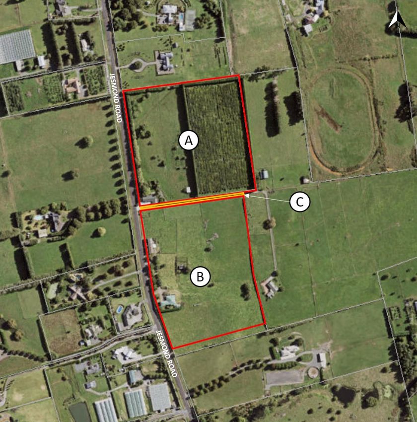
| Drury West Secondary School Notice of Requirement AEE // February 2021 |

Revision History
 Revision Nº              Prepared By                                      Description                                                     Date
 1                        Kristina Gurshin                                 Draft for client review                                         25 November 2020

 2                        Kristina Gurshin                                 Updated from client review                                      18 December 2020

 3                        Kristina Gurshin                                 Soft lodgement with Auckland Council                            18 January 2021

 4                        Kristina Gurshin                                 Final lodgement with Auckland                                   8 March 2021
                                                                           Council

Document Acceptance
 Action                   Name                                             Signed                                                          Date
 Prepared by              Kristina Gurshin                                                                                                 22 February 2021

 Reviewed by              Jamie Swan                                                                                                       22 February 2021

 Approved by                                                                                                                               8 March 2021

 on behalf of             Beca Limited

© Beca 2021 (unless Beca has expressly agreed otherwise with the Client in writing).

This report has been prepared by Beca on the specific instructions of our Client. It is solely for our Client’s use for the purpose for which it is intended in accordance
with the agreed scope of work. Any use or reliance by any person contrary to the above, to which Beca has not given its prior written consent, is at that person's own
risk.

                                                           Drury West Secondary School Notice of Requirement AEE (February 2021) | 4287983-627069363-15 | 22/02/2021 | i
Contents

Overview ................................................................................................................... 1
1    Introduction ........................................................................................................ 2
2    Description of the Designation ........................................................................ 3
     2.1    The Minister’s Objectives................................................................................................................. 3
     2.2    Purpose of the Designation ............................................................................................................. 3

3    The Existing Environment ................................................................................ 9
     3.1    Zoning ............................................................................................................................................ 10
     3.2    Surrounding Road Network Environment ...................................................................................... 11
     3.3    Contamination ................................................................................................................................ 12
     3.4    Archaeological and Cultural Heritage ............................................................................................ 12
     3.5    Geotechnical Investigations ........................................................................................................... 13

4    Assessment of Environmental Effects .......................................................... 14
     4.1    Positive Effects .............................................................................................................................. 14
     4.2    Landscape Effects ......................................................................................................................... 14
     4.3    Visual Effects ................................................................................................................................. 15
     4.4    Effects on Property Access............................................................................................................ 15
     4.5    Traffic Effects ................................................................................................................................. 15
     4.6    Noise Effects .................................................................................................................................. 17
     4.7    Construction Effects....................................................................................................................... 17
     4.8    Conclusion ..................................................................................................................................... 18

5    Alternative Sites and Methods ....................................................................... 19
     5.1    Site Selection Methodology ........................................................................................................... 19
     5.2    Identifying a preferred site ............................................................................................................. 21
     5.3    Review of alternative site options .................................................................................................. 22
     5.4    Alternative Methods ....................................................................................................................... 23

6    Statutory Assessment ..................................................................................... 25
     6.1    The Resource Management Act 1991 ........................................................................................... 25
     6.2    National Policy Statement for Urban Development 2020 .............................................................. 27
     6.3    Auckland Unitary Plan: Operative in Part (AUP:OP) ..................................................................... 27

7    Consultation ..................................................................................................... 31
     7.1    Landowners ................................................................................................................................... 31
     7.2    Auckland Council ........................................................................................................................... 31
     7.3    Fire and Emergency New Zealand ................................................................................................ 32
     7.4    Franklin and Papakura Local Board .............................................................................................. 32
     7.5    Mana Whenua ............................................................................................................................... 33

8    Proposed Conditions ...................................................................................... 35
     8.1    Lapse Date .................................................................................................................................... 35
     8.2    Standard Conditions Applying to All Schools ................................................................................ 35

                                                   Drury West Secondary School Notice of Requirement AEE (February 2021) | 4287983-627069363-15 | 22/02/2021 | ii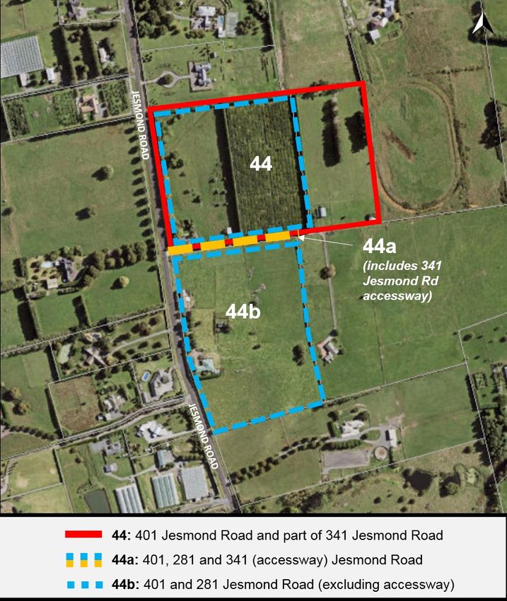
8.3    Additional Site-specific Conditions ................................................................................................ 36

9   Conclusion ....................................................................................................... 39

Appendices

Appendix A – Integrated Transport Assessment
Appendix B – Detailed Site Investigation
Appendix C – Geotechnical Investigation
Appendix D – Consultation
Appendix E – Summary of Assessment of Additional Alternative Site
  Options

                                              Drury West Secondary School Notice of Requirement AEE (February 2021) | 4287983-627069363-15 | 22/02/2021 | iii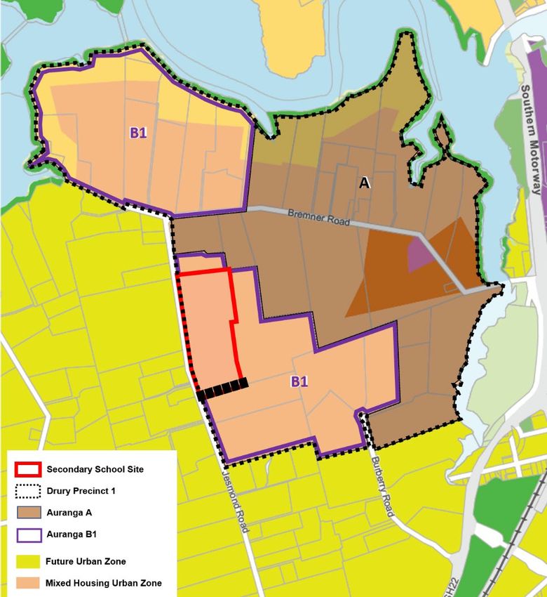
| Overview |

Overview
Requiring authority:               The Minister of Education

Objective:                         The establishment and operation of a Secondary School for
                                   students in years 7 to 13 and an Early Childhood Education Centre
                                   (ECE)

Site address:                      A combination of the following addresses:
                                   • 401 Jesmond Road, Drury West
                                   • Part 281 Jesmond Road, Drury West
                                   • Part 341 Jesmond Road, Drury West

                                   together “the Site”

Legal description:                 Land to be designated affects the following titles (refer to Figure 2):
                                   • Area A - Lot 1 DP 139263 (NA82D/39)
                                   • Area B - part Lot 1 DP 89570 (NA46D/240)
                                   • Area C - part Lot 2 DP 164625 (NA99A/988)

Landowners:                        Land to be designated affects the following landowners:
                                   • 401 Jesmond Road – Her Majesty the Queen (“the Crown”)
                                   • 281 Jesmond Road – Her Majesty the Queen (“the Crown”)
                                   • 341 Jesmond Road – Elly S Pan and Benjamin Ban Chong Bong

Site area:                         Approximately 8.42ha

Relevant legislation:              Notice of Requirement for a designation under Section 168 of the
                                   Resource Management Act 1991

Designation sought:                ‘Educational Purposes – being a Secondary School (years 7 to 13)
                                   and an Early Childhood Education Centre (preschool).’

Underlying District Plan zoning:   Residential – Mixed Housing Urban Zone

Additional consents:               Development related activities for the Site may require resource
                                   consents for disturbance of contaminated land, stormwater
                                   discharge, earthworks and dewatering depending on the design
                                   solutions pursued. These consents will be sought prior to
                                   construction commencing.

                                            Drury West Secondary School Notice of Requirement (February 2021) | 4216997 | 22/02/2021 | 1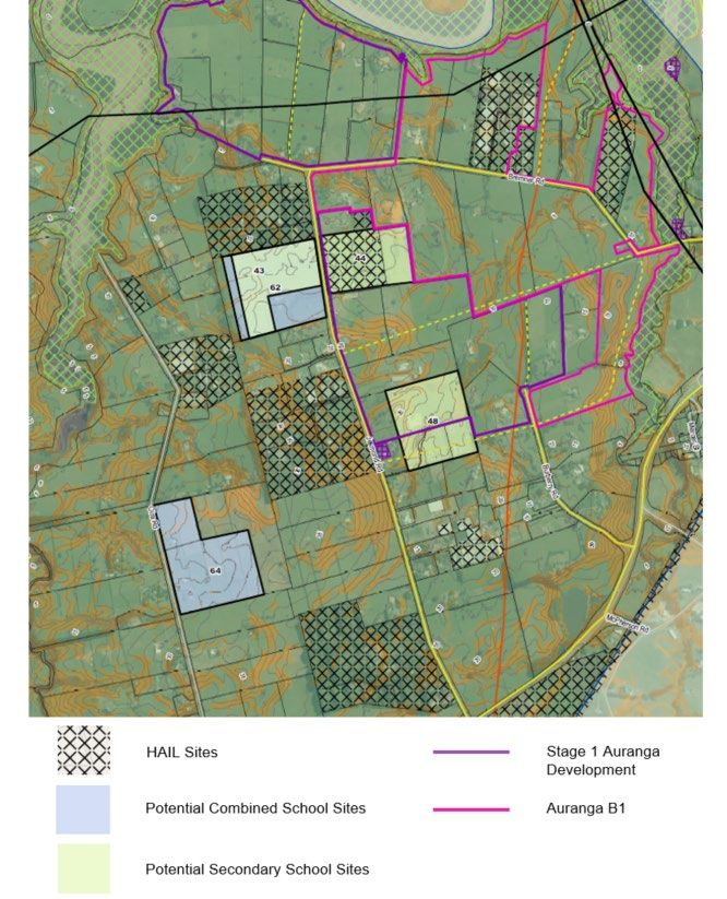
| Introduction |

1       Introduction
This document and attachments provide the information and assessment required under Sections 168 and
171 of the Resource Management Act 1991 (‘the RMA’) in respect of a Notice of Requirement (‘NoR’) by the
Minister of Education (‘the Minister’) to designate land for educational purposes in Drury West.

1.1.1 Urban Growth
Drury West is an area of partially developed greenfield land that has been the subject of several plan
changes to zone it for residential land use which will enable the supply of 5,100 to 9,800 new residential
dwellings across 1,016ha of land 1.
The designation will enable the future development of important social infrastructure for this new residential
area, specifically a new secondary school (years 7-13) and an Early Childhood Education Centre (ECE). The
future school and ECE are necessary to meet the demand for education facilities that will be generated by
future urban growth in and around Drury West.

                             Figure 1 Proposed school and ECE site location (AUP:OP)

At present the surrounding land uses are predominantly rural and rural-residential in nature. However, this
area is expected to experience significant urban growth in the short to medium term, given the rezoning and
developer interest in the area.

1
    Drury West Structure Plan (May, 2017)

                                                   Drury West Secondary School Notice of Requirement (February 2021) | 4216997 | 22/02/2021 | 2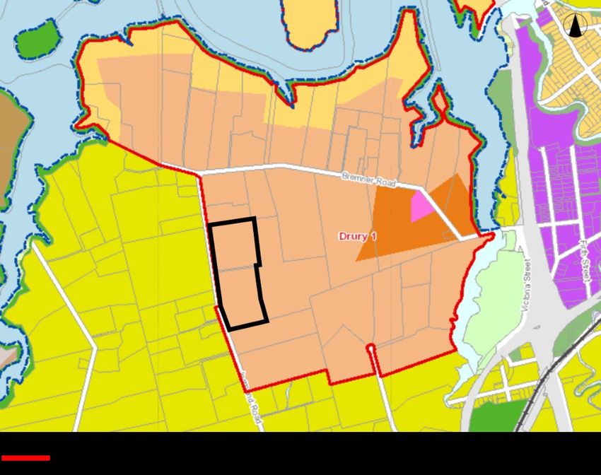
| Description of the Designation |

2     Description of the Designation

2.1 The Minister’s Objectives
The Minister is a requiring authority under section 166 of the RMA. The Minister has financial responsibility
for state owned and funded schools and has the ability to submit a notice of requirement for a designation for
such works.

The Education and Training Act 2020 mandates the Minister to designate schools. Those elected to the
Board of Trustees are legally responsible for the management of their school, in the same manner as applies
to all other State schools.
Accordingly, the establishment of a secondary school catering for school age children from years 7-13, as
well as the provision for ECE facilities catering for preschool children, is reasonably necessary in achieving
the objective of the Minster in providing state schooling.
A designation is considered to be the appropriate mechanism to provide for the establishment and ongoing
operation of the school and ECE. The Minister requires ongoing certainty that the Site can be developed and
used for this purpose. Designations provide the necessary long-term certainty and flexibility for operation of a
school and ECE on the Site, while also identifying the use of the Site to the general public. The majority of
State schools within Auckland Council’s jurisdiction and across New Zealand have been designated by the
Minister for education purposes.

2.2 Purpose of the Designation
The purpose of the designation is to provide for the future development of educational facilities on the Site.
As set out in the attached NoR (Form 18) the Site is to be designated for ‘Educational Purposes – being a
Secondary School (years 7 to 13) and an Early Childhood Education Centre (preschool)’.
“Educational Purposes” for this designation will adopt the standard education purpose definition and wording
as set out in the ‘Standard Conditions for All Education Designations’ in the ‘Designation Schedule – Minister
of Education’ contained in the AUP:OP:

1. Each of these designations enables the establishment of a school that is able but is not required to cater
   for all the school years listed in the designation description.
2. “Educational Purposes” for the purposes of these designations shall, in the absence of specific
   conditions to the contrary:
        (i)      Enable the use of the facilities on the designated site by and for the educational benefit of
                 any school age students (ie: years 0 to 13) regardless of whether they are enrolled at any
                 institution located on that designated site.
        (ii)     Enable the provision of supervised care and study opportunities for students outside school
                 hours in school facilities
        (iii)    Enable the provision of community education (eg: night classes for adults) outside school
                 hours in school facilities
        (iv)     Include but not be limited to the provision of academic, sporting, social and cultural
                 education including through:
                    – Formal and informal recreational, sporting and outdoor activities and competitions
                        whether carried out during or outside school hours;
                    – Formal and informal cultural activities and competitions whether carried out during or
                        outside school hours; and

                                                  Drury West Secondary School Notice of Requirement (February 2021) | 4216997 | 22/02/2021 | 3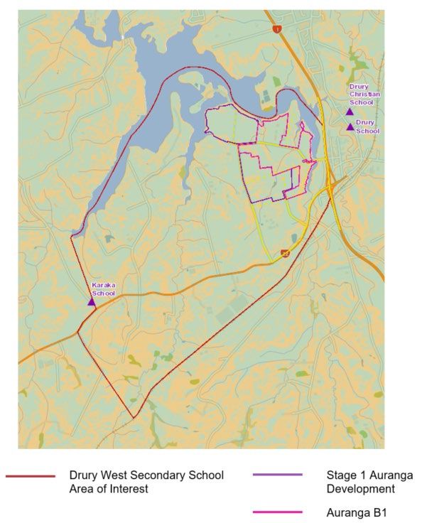
| Description of the Designation |

                  – The provision of specialist hubs and units (including language immersion unites and
                     teen parent units) for students with particular educational requirements or special
                     needs.
       (v)    Enable the use of facilities for purposes associated with the education of students including
              school assemblies, functions, fairs and other gatherings whether carried out during or
              outside school hours.
       (vi)   Enable the provision of associated administrative services; carparking and vehicle
              manoeuvring; and health, social service and medical services (including dental clinics and
              sick bays).
       (vii)  Enable the housing on site for staff members whose responsibilities require them to live on
              site (eg: school caretaker) and their families.
3. Where any standard condition conflicts with a site specific condition, the site specific condition shall take
   precedence.

                                                   Drury West Secondary School Notice of Requirement (February 2021) | 4216997 | 22/02/2021 | 4
| Description of the Designation |
The extent of the designation is illustrated below in Figure 2 relative to existing parcels of land:
Site Site Address Legal Description
A 401 Jesmond Road Lot 1 DP 139263
B Part of 281 Jesmond Road Part Lot 1 DP 89570
C Part of 341 Jesmond Road Part Lot 2 DP 164625
Figure 2 Designation Plan (AUP:OP)
2.2.1 Timing
The Ministry currently anticipates that a new secondary school will be required to open within the next 10
years. The opening of the school is highly dependent on the speed of development in the surrounding area.
Consequently, the Minister has requested a 10 year lapse period for this NoR.
2.2.2 Built form and layout
Detailed design for the school and ECE has not yet been undertaken and is likely to be a number of years
away. The design of the school is expected to consider location of school buildings (classrooms, hall, library,
gymnasium, office space, and ancillary activities), playing fields, hardcourts, playground structures, vehicle
Drury West Secondary School Notice of Requirement (February 2021) | 4216997 | 22/02/2021 | 5| Description of the Designation |
accessways, parking, pick up / drop off (PUDO) area, loading bays, footpaths, landscaping, fencing and
servicing (including water, sewer, stormwater, electricity, telecommunications, and outdoor lighting).
2.2.3 Outline Plan Process
Prior to construction commencing, the Ministry of Education (Ministry) will prepare a concept design for the
Site and lodge an Establishment outline plan to Auckland Council (the Council). As required by section 176A
of the RMA, the outline plan will show the height, shape and bulk of the school and ECE facility (the Work),
the location and likely finished contour of the Site, vehicle access, circulation and the provision for parking,
proposed landscaping and any other matters required to avoid, remedy or mitigate any adverse effects on
the environment.
2.2.4 Access
The Site has approximately 460m of frontage onto Jesmond Road along its western boundary. The
Integrated Transport Assessment (ITA), attached as Appendix A, recommends that, in the absence of any
alternatives, the main vehicle, pedestrian and cycle access to the Site be from Jesmond Road. Whilst
currently a rural road, Jesmond Road is identified in the Auckland Unitary Plan: Operative in Part (AUP:OP)
to be potentially upgraded to a Collector Road, a road classification for roads designed to accommodate up
to 10,000 vehicles per day according to the Auckland Transport Code of Practice.
The AUP:OP’s example of a collector road cross-section indicates that its future form is expected to include
a wide road reserve with two traffic lanes, shared path on both sides of the road, an on-road cycle lane on
both sides of the road and a wide landscape strip with street trees, stormwater devices and parking on both
sides of the road.
Access to the Site may also be possible from a future East-West Collector Road which is currently being
investigated by Auckland Transport (AT) and is expected to adjoin or run close to the southern border of the
Site. At this stage this road is only indicative and has not been designated. The 2016 Preferred Network
Plan for the South 2 states that the road is proposed to provide a new east-west transport connection between
the existing Drury Town Centre and an indicative potential new local town centre in Drury West. This new
road is anticipated to accommodate vehicles, pedestrians, cyclists and public transport.
The ITA also considers whether the site is capable of providing safe access and efficient circulation and
recommends how this can be achieved within the designated Site. In summary, the ITA concludes that while
there is uncertainty around the future land use and transport environment at the time the school will be
established, there is potential for safe access to be obtained directly from the Site.
The ITA recommends:
● Preparation of a School Design Concept Plan and Establishment outline plan;
● Preparation of a Transport Assessment (TA) at the Establishment outline plan stage, close to when the
school and ECE is about to be constructed;
● Main vehicular access to the Site off Jesmond Road, with potential upgrades to the corridor in the future
to a collector road as anticipated by the AUP:OP;
● Vehicle accesses separated from the main pedestrian and cycle accesses;
● Opportunities for access from other roads may be provided from a proposed future East-West Collector
Road along the southern boundary of the Site;
2
https://nzta.govt.nz/assets/projects/Supporting-Growth-Delivering-transport-networks/South/network-for-the-
south.pdf
Drury West Secondary School Notice of Requirement (February 2021) | 4216997 | 22/02/2021 | 6| Description of the Designation |
● Development of a School Travel Plan to identify safe access to the entry points of the Site consider
features such as crossings and measures to separate vehicle entry and pedestrian/cyclist entries,
manage student car parking and details of the school bus strategy; and
● Preparation of a Construction Traffic Management Plan to be submitted with the Establishment outline
plan for major site works.
Final details of access arrangements will be provided for Council review as part of the outline plan process.
The Ministry will liaise with Council and Waka Kotahi New Zealand Transport Agency (Waka Kotahi) at the
time of developing a School Design Concept Plan which will then be submitted at the outline plan stage,
setting out in further detail the proposed access arrangements to the Site.
2.2.5 Parking
The ITA recognises that the site (approximately 8.42ha) is large enough to cater for PUDO areas for cars
and buses and parking.
Specific details of the car and cycle parking layout and loading spaces will be provided at the outline plan
stage and in the School Design Concept Plan, once the Site has been designed. A School Travel Plan will
also include details of the school bus strategy, including on-site pick-up and drop-off for buses and on-site
parking arrangements.
2.2.6 Wastewater and stormwater
The Site is currently an unserviced greenfield site.
The development of the school and ECE is directly related to the urbanisation of the surrounding area. The
school will connect to the reticulated stormwater and wastewater network when it becomes available. It is
likely that the Site will be drained via a combination of a gravity pipe network and conveyance channels
along the Site boundaries which discharge to the connection/s put in place. If necessary, the Ministry could
provide on-site detention/retention and dispose of waste on-site temporarily until the public system becomes
available.
The Site naturally drains via overland flow path into unnamed watercourses which ultimately discharge into
Drury Creek. Council GIS identifies that a flood plain and overland flow path is located on the North West
corner of 401 Jesmond Road. Overland flow paths on-site will need to be maintained or modified to suit the
development. Secondary flow paths between the school and ECE buildings and the playing field or carpark
areas can be provided with discharge to the street systems. This will be reviewed and confirmed with Council
in the outline plan for the development of the Site.
The Site is not within any Stormwater Management Area as defined in the AUP:OP. However, on-site
stormwater management is a requirement stipulated in the regional rules set out for the Drury 1 Precinct and
principles of Water Sensitive Design will apply. The detailed design will be developed in accordance with
these rules and any necessary resource consents will be sought under the AUP:OP prior to works taking
place.
2.2.7 Potable and Fire Fighting Water
Watercare advises that there will be capacity to service the Site and the surrounding area when required
(refer to Appendix D for email correspondence).
Fire and Emergency New Zealand has been notified of this project and had no questions. Refer to section
7.4 and Appendix D for further information.
Drury West Secondary School Notice of Requirement (February 2021) | 4216997 | 22/02/2021 | 7| Description of the Designation |
2.2.8 Other Services
The only nearby underground infrastructure is a Vector underground electricity transmission line located
approximately 460m from the eastern boundary of the Site. Power and telecommunication supplies will be
provided to the area as part of the developments nearby, prior to development being undertaken on the Site.
Drury West Secondary School Notice of Requirement (February 2021) | 4216997 | 22/02/2021 | 8| The Existing Environment |
3 The Existing Environment
The Site is located approximately 2km west of the existing Drury township at the northern end of Jesmond
Road and is approximately 8.42 hectares in area. The Site is made up of one entire parcel of land, which is
identified as Area A (Lot 1 DP 139263) and part of two parcels including part of Area B (part Lot 1 DP 89570)
and part of a right of way (part Lot 2 DP 164625) identified as Area C, as illustrated in Figure 3 and the Land
Requirement Plan included in Attachment 1 of Form 18. The Records of Title are included in Attachment 2 of
Form 18.
Figure 3 Site Configuration (AUP:OP)
Area A is approximately 4.1ha in size of which half is used for lifestyle and the other for horticultural uses.
The land is relatively flat with a high point at the southeast corner of the site and gently falling to the
northeast corner. An existing dwelling is located in the south western corner of the site.
Area B is approximately 4.2ha in size, generally used for rural lifestyle purposes with an existing dwelling at
the high point of the site in the southwestern quadrant. The land then falls northwards to a generally flat
area.
Drury West Secondary School Notice of Requirement (February 2021) | 4216997 | 22/02/2021 | 9| The Existing Environment |
Area C is part of a right of way that provides access to private property at 341 Jesmond Road, and over
which the Crown has an interest by virtue of Easement Certificate C164709.3 (the Right of Way Land). The
Minister is currently in the process of acquiring Area C.
All three parcels of land are currently accessible from Jesmond Road.
3.1 Zoning
Under the AUP:OP the site is zoned “Mixed Housing Urban Zone” within the Drury 1 Precinct (as indicated in
Figure 4 and 5).
Figure 4 Zoning Map (AUP:OP)
The current surrounding land uses are predominantly rural and rural-residential in nature. However, to the
north and the east of the site land is currently being developed to enable the construction of up to 1,300
residential dwellings (Auranga A). This will introduce to the Drury West area a mixture of residential dwelling
types, for example single dwellings, terraced housing and apartment buildings, and new local commercial
centres.
Drury West Secondary School Notice of Requirement (February 2021) | 4216997 | 22/02/2021 | 10| The Existing Environment |
Figure 5 Proposed school and ECE site location (AUP:OP)
3.2 Surrounding Road Network Environment
The ITA has been prepared as a high-level transport assessment which recognises that there is some
uncertainty around the future planned land use and transport environment surrounding the Site.
3.2.1 Future Planning Network
As discussed above, the ITA highlights that there is uncertainty with the future planned land use and
transport environment immediately surrounding the Site. The key reasons include that there is no approved
plan change for the land zoned Future Urban Zone to the west and south of the Site and Auckland Transport
(via the Supporting Growth Alliance (SGA)) is still to confirm key elements of the future transport network
(refer to ITA for details).
The ITA recognises that the Site will be located centrally within the overall residential catchment once the
Auranga development and Future Urban Zone land is developed. Karaka and Drury Consultant Limited (the
Auranga developer) proposes to develop quality walking and cycling facilities within these areas, which will
enable easy and convenient access to the school via a range of alternative modes including walking and
cycling. Jesmond Road is likely be upgraded to a Collector Road standard and as such will be designed to
carry traffic volumes of approximately 10,000 vehicles per day.
Drury West Secondary School Notice of Requirement (February 2021) | 4216997 | 22/02/2021 | 11| The Existing Environment |
3.3 Contamination
Beca was commissioned by the Ministry to undertake a Detailed Site Investigation (DSI) of two of the land
parcels that make up the Site. Those sites are 401 Jesmond Road (Area A) and 281 Jesmond Road (Area
B) (refer to Figure 2) and the DSI reports attached in Appendix B.
Based on the information provided in the Preliminary Site Investigation (PSI) and the subsequent soil
analytical results provided in the DSI, it can be concluded on a “more likely than not” basis that HAIL code
E1 (asbestos in a deteriorated condition) is applicable to the site at 281 Jesmond Road 3. An Asbestos
Management Control Plan will be required for the ongoing management of the stables area and removal of
the asbestos containing material from around the stables will require to be undertaken by a licensed
asbestos removal company. The land disturbance activities associated with the proposed development will
require resource consent under Regulation 10 of the NESCS as a Restricted Discretionary activity.
For 401 Jesmond Road, soil analytical results show the concentrations of DDE and DDT contaminants are
below the adopted human health risk and environmental discharge risk criteria 4. Standard management
controls will apply to this site. The soil disturbance activities and change in land use associated with the
proposed development will require resource consent under Regulation 9 of the NESCS as a Controlled
activity.
Given that there have been HAIL activities on both Areas A and B, the relevant National Environmental
Standard for Assessing and Managing Contaminants in Soil to Protect Human Health (NES) requirements
will apply and a separate NES consent will be sought by the Ministry prior to commencing construction.
3.4 Archaeological and Cultural Heritage
A desktop review of online databases and records was undertaken to identify sites of archaeological and
cultural significance within proximity to the proposed school site.
3.4.1 Archaeological sites
According to the New Zealand Archaeological Association ArchSite Map 5, there are no identified sites of
archaeological significance within approximately 500m of the proposed school site.
3.4.2 Cultural heritage
The AUP:OP Cultural Heritage Inventory (CHI) has identified a historic structure (CHI No.2455) at 201
Jesmond Road. The structure is recorded as “The Aroha Cottage Playmasters House” and is located
approximately 280m south of the Site. There is no anticipated disturbance to the historic structure as a result
of the school designation.
3
Detailed Site Investigation (Contamination), MoE Drury Due Diligence, 281 Jesmond Road. Prepared for
Ministry of Education by Beca Limited, 5 September 2018
4
Detailed Site Investigation (Contamination), MoE Drury Due Diligence, 401 Jesmond Road. Prepared for
Ministry of Education by Beca Limited, 31 August 2018
5
New Zealand Archaeological Association. (2018). ArchSite Browse Map.
https://archsite.eaglegis.co.nz/NZAA/Map
Drury West Secondary School Notice of Requirement (February 2021) | 4216997 | 22/02/2021 | 12| The Existing Environment |
3.5 Geotechnical Investigations
A preliminary geotechnical review of the land at 281 and 401 Jesmond Road, Drury West, has been
undertaken by Beca Limited (Beca). The geotechnical assessment report attached in Appendix C was based
on an assessment of desktop data and site investigations 6.
According to the Council Geomaps viewer, the topography of 281 Jesmond Road varies in elevation from
approximately RL 15.5m to 26.5m. The higher ground comprises a narrow ridge extending from the existing
house adjacent to Jesmond Road eastward across the land parcel. The ground slopes down to the northeast
and southwest from the ridge, with moderate slopes from the top of the ridge for 20 to 35m, then gently
slopes beyond the ridge. Council Geomaps viewer identifies that a seepage point is located in the southwest
(SW) corner of the site and that there are no other water courses mapped on the property.
The topography of 401 Jesmond Road ranges from RL12.5 to 16.5m. The ground surface is generally gently
sloping from the highest point in the south west corner, near the 281 Jesmond Road property boundary
sloping to the northeast. There are a few undulating areas including two small mounds that rise about 1.5m
in the centre of the site. The ground contours indicate a gully with slopes in the northeast (NE) corner of the
property. A spring (groundwater seep) also occurs in this area. A shallow surface drain is apparent along the
northern property boundary as observed from the 2018 Google earth image. An overland flowpath is mapped
across the northern part of the site, with some secondary branching into the site.
The published geological map (Edbrooke, 2001) indicates that this site is underlain by Puketoka Formation
sediments, including mud, silts, pumiceous silty sands, interbedded with organic layers, and overlain by
weathered volcanic soils.
Overall, the geotechnical assessment report concludes that the Site is in generally good condition for a
school development. The geology of the site does not require any constraints on the layout of the school.
Further geotechnical testing and investigation will take place as part of the detailed design stage to address
any specific design and foundation requirements.
6
Edbrooke, S.W (compiler), 2001: Geology of the Auckland Area. Institute of Geological and Nuclear
Sciences 1:250,000 geological map 3; Lander Geotechnical, 2017: Preliminary Geotechnical Appraisal
Report for Auranga Development B1, Drury; and Papakura District Council (unknown date): Papakura
District CBR strength of soils, CBR01 Rev 0, 1:25,000 at A1 map
Drury West Secondary School Notice of Requirement (February 2021) | 4216997 | 22/02/2021 | 13| Assessment of Environmental Effects |
4 Assessment of Environmental Effects
The Minister proposes a lapse date of 10 years for this designation. As such, it will be given effect to at some
time between 2021 and 2031. During this time, occupation of planned residential development within Drury
West is expected to progress. The ultimate timing of construction of the school will be dependent on the
pace of growth. The school and ECE are likely to be built in stages with the roll gradually increasing over a
number of years.
Despite the likely progressive growth of the school, for the purposes of assessing the environmental effects
of developing a school in this location, a roll of 2,500 students has been used. This assessment of
environmental effects has also been undertaken in the absence of a specific design for the Drury West
Secondary School, which will be developed closer to the time of construction and provided through the
outline plan process.
The assessment has identified positive effects and potential adverse transport effects, effects on amenity,
character and temporary effects during construction. These are considered in the context of standard
Ministry schools and ECEs and their expected effects on the existing and future environment. Temporary
construction-related effects (which may occur in stages) include traffic effects, noise effects and earthworks
effects including dust.
4.1 Positive Effects
Designating the Site for a secondary school and ECE will have positive social and economic effects through:
● The new learning environments providing opportunities to advance the social well-being of children and
students;
● Providing of an important piece of social infrastructure (being educational facilities) for the new residential
community including as a focal point in the new local area;
● The strategic location, central to the large catchment of residents providing excellent opportunities for
pupils to travel to school by public transport, walking or cycling; and
● The co-location of an ECE and secondary school which will have positive effects in terms of convenience
for families with interest in both facilities.
4.2 Landscape Effects
The Site is currently in use for rural and rural-residential purposes. Land to the east of Jesmond Road is
zoned Residential Mixed Urban whereas land to the west is zoned Future Urban under the AUP:OP.
The development of a secondary school and ECE in this location will be in response to demand created by
the urbanisation of this land to the west and east of Jesmond Road. Therefore, for the Site, the future
development on land designated for education should be considered in the context of a future urban
residential environment.
Schools and ECEs are accepted and expected parts of a residential community given it is the residential
community that they serve. They are generally set within grassed playing fields and other play areas and, by
interrupting more intensive residential development, have the potential to contribute positively to the
landscape character and amenity of surrounding areas. Design and landscaping elements will be considered
at the outline plan stage and can be designed to be sympathetic and congruous with the immediate and
extended site surrounds and landscape.
Overall, the development of a school and ECE in this location will not result in adverse effects on the
character of the future residential environment.
Drury West Secondary School Notice of Requirement (February 2021) | 4216997 | 22/02/2021 | 14| Assessment of Environmental Effects |
4.3 Visual Effects
Visual effects result from changes to specific views and the visual amenity experienced by people. The exact
timing of the development of the school and ECE in this location is uncertain and will be in response to
demand. However, as the designation has a 10 year lapse date these effects can be anticipated to occur
within this timeframe. The use of this land for educational purposes may or may not precede some or all of
the residential development adjacent to the Site. Notwithstanding this, the Ministry has existing standard
designation conditions as set out in the ‘Standard Conditions for All Education Designations’ in the
‘Designation Schedule – Minister of Education’ under the AUP:OP which will be applied to this site to
mitigate the potential visual effects on surrounding properties (being height in relation to boundary controls to
protect daylight and dominance effects). The standard conditions are outlined in Section 2.2 of this NoR.
The school buildings will also be set within a significant landholding (approximately 8.42ha) which will have
large grounds of open space and landscaping. Details of proposed landscaping will be provided with the
outline plan once the design for the school and ECE has been developed.
Overall, schools and ECEs are an accepted and expected part of suburban, rural and future urban areas
such as Drury West. Future development of the site for the purposes of an educational facility is unlikely to
have significant adverse visual effects on the surrounding newly urbanised area given the size of the site and
controls in place to protect daylight and dominance.
4.4 Effects on Property Access
The future acquisition of land shown as Area C has the potential to adversely affect access to the property at
341 Jesmond Road. However, this effect will not occur until such time as Area C is acquired and
subsequently utilised for construction or operation of the new school.
The potential adverse effect on access to 341 Jesmond Road can be avoided by providing a viable alternate
access route. The options are to relocate the right of way connection along the northern (401 Jesmond
Road) or southern (281 Jesmond Road) boundary of the school site and either selling this land to the owners
of 341 Jesmond Road, or creating an easement over the proposed school site for this purpose.
Overall, until such time as the Right of Way Land is acquired and used for construction or operation of a
school there will be no effect on the access to 341 Jesmond Road. Mitigation options are available to provide
an alternative access to the balance land.
4.5 Traffic Effects
The ITA considers the effects of traffic generation associated with the new facilities on the future road
network as well as the accessibility of the school and ECE for all mode of transport (vehicle, public transport,
walking and cycling).
4.5.1 Traffic generation
Schools and ECEs generate traffic volumes which are generally concentrated around drop-off and pick-up
times. The ITA considers the potential adverse effects of traffic generation associated with the new facilities
on the future new road network as well as the accessibility of the school for all modes of transport (car, bus,
cycle and walking).
With regards to mode share, the ITA recognises that the school will be centrally located within Drury West.
The Site will therefore be attractive for students to walk and cycle to school - most of the residential dwellings
proposed in the Auranga Stage 1 and Stage 2 developments will be within a 15 minute walk or a 7 minute
cycle ride. A higher than average walking and cycling mode share is therefore anticipated.
Drury West Secondary School Notice of Requirement (February 2021) | 4216997 | 22/02/2021 | 15| Assessment of Environmental Effects |
As set out earlier, Jesmond Road is currently a rural road with low traffic volumes. The timing and staging of
an upgrade to transition Jesmond Road to an urban road standard will be dependent on the pace of
surrounding residential development. Equally, the development of a school on the Site within the next 10
years will be in response to this same development. The ITA states that once Jesmond Road is upgraded to
a Collector Road it will have appropriate capacity to accommodate the predicted secondary school trips
given the road will be designed to carry traffic volumes of approximately 10,000 vehicles per day.
Section 8 of this report sets out the proposed conditions for the school and ECE. The potential adverse
effects of traffic generated on the road network will be considered in more detail through a detailed Transport
Assessment (TA) prepared at the Establishment outline plan stage when the land use and transport
environment information are better known. Engagement with Auckland Transport, Auckland Council, and
Waka Kotahi will help inform the TIA. This framework provides the ability to consider the impact of the
unlikely event of the school progressing before the road is upgraded.
4.5.2 Jesmond Road/SH22 Intersection
The designation of land for educational purposes has the potential to have adverse effects on the safe and
efficient operation of the State Highway network. In particular, the intersection of SH22/Jesmond Road
around PUDO times.
As there is uncertainty over the timing of the upgrades to the transport network, it is recommended that any
effects on the intersection is assessed via the preparation of a TIA at the outline plan stage to assess the
traffic generation and any means of mitigating adverse effects on the efficiency and safety of the surrounding
transport network. This mitigation is reflected proposed condition one in section 8.2 of this report.
Notwithstanding this, the Drury 1 Precinct subdivision controls require the upgrade of the Jesmond Road /
SH22 intersection to occur before subdivision and development can occur in the Precinct Plan 2 area. The
residential development is contingent on the upgrade of the intersection which, in turn, will drive the demand
for the new secondary school. As such, the intersection upgrade is programmed to precede the residential
development.
Given the planned upgrades and the recommended conditions to engage with the road controlling authorities
as part of the development of a more detailed TIA at the outline plan stage, any adverse effects on this
intersection can be appropriately managed.
4.5.3 On-site parking
The designation of land for educational purposes will result in demand for on and off-street car and cycle
parking for students, staff and visitors. Peak demand for car parking is generally around short periods during
drop-off and pick-up times. Providing on-site PUDO facilities for use by cars and (potentially) buses as well
as parking for secondary school and ECE staff and visitors will reduce the demand for on-street parking and
make these spaces available for non-school activities. At approximately 8.42 hectares, the site is large
enough to cater for on-site PUDO areas, to the extent required.
As set out in the ITA, the centrally located site and form of the proposed roading network in this new urban
area will make walking and cycling attractive options for travelling to school. The ITA recommends that a
School Travel Plan be prepared to assist in supporting and achieving the desired mode share.
Notwithstanding this, to mitigate potential adverse effects from parking demand, it is recommended in the
ITA that a more detailed TA be prepared and submitted with the Establishment outline plan, at which time
the location and form of parking areas will be confirmed.
Drury West Secondary School Notice of Requirement (February 2021) | 4216997 | 22/02/2021 | 16| Assessment of Environmental Effects |
4.5.4 Access
At present the Site only has frontage to Jesmond Road. The length of frontage, at 460m, is assessed in the
ITA as being sufficient to provide safe access to the school for pedestrians, cyclists and vehicles and to
distribute traffic across the site as necessary.
The location and form of access to the Site will be confirmed at the Establishment outline plan stage and
informed by a TIA prepared at the time, taking into account the outcomes of consultation with Auckland
Transport.
Conclusion
Overall, the Site is of sufficient size to accommodate on-site parking and PUDO facilities and has sufficient
road frontage to provide for access arrangements for different modes (vehicle, pedestrian, cyclist) and
functions (visitor, staff, ECE parking). The conditions framework out allow for more detailed consideration of
potential adverse effects on the surrounding road network closer to the time of construction.
4.6 Noise Effects
The designation of land in Drury West for educational purposes is on land that is currently used for rural
activities but is zoned “Mixed Housing Urban”. It is anticipated that the surrounding land will ultimately be
developed for residential or open space (subject to future plan changes). The following assessment of noise
considers both the existing rural land use and future residential zoning.
Schools and ECEs are an accepted part of urban environments and their noise effects are well known. The
nature of educational activities is such that the noise generating activities (particularly outdoor education,
outdoor play times and vehicle-based drop-off and pick-up) are during defined hours of the day during the
week. Noise generation in evenings, night-time and weekends is typically very low or non-existent.
As such, it is not envisaged that the designation of land on the Site will result in noise levels which are
objectionable beyond the school boundary, or which create significant adverse effects in future residential
environments adjacent to the site.
Notwithstanding this assessment, the Minister has standard conditions that apply to designated schools in
the AUP:OP to address potential adverse noise effects during construction and operation which are
proposed to also apply to this designation (refer to section 8.1.2 of this report).
Overall, having regard to the above assessment and proposed designation conditions it is considered that
noise levels from the operation of the facilities are unlikely to cause adverse effects on the surrounding
environment and will be appropriately managed through the existing standard conditions imposed by the
Minister on all schools in the Auckland region.
4.7 Construction Effects
The temporary effects arising from this work relate to the construction phase of the proposal. The effects of
construction are considered to be noise, dust, traffic and the potential for unearthing of archaeological
remains or artefacts.
Given the relatively flat nature of the site it is not envisaged significant earthworks will be necessary to create
building platforms. Construction works will be undertaken in accordance with the New Zealand noise
standards NZS 6803:1999 Acoustics – Construction Noise. Construction traffic will be able to access the site
from the northern and eastern boundaries.
The Minister has a standard condition of the designation that a Construction Management Plan be prepared
and submitted with any outline plan for major site works (refer to section 8.1.2 of this report). Such a plan
would set out the practices and procedures to be adopted to ensure compliance with conditions on the
Drury West Secondary School Notice of Requirement (February 2021) | 4216997 | 22/02/2021 | 17| Assessment of Environmental Effects |
designation and otherwise to minimise the effects of construction activities on the surrounding properties.
(refer to section 8.2 of this report).
Overall, construction effects will be temporary in duration with potential effects addressed as part of the
outline plan.
4.8 Conclusion
Overall, the designation to provide for the future development of a school and ECE on the Site will have
positive social and economic effects on the new community.
The potential adverse effects of the activities authorised by the NoR relating to amenity and character, traffic
and noise are able to be avoided, remedied or mitigated to an acceptable degree through the outline plan
process and through the conditions set out in section 8 of this report. Avoidance, remedy or mitigation of loss
of access associated with 341 Jesmond Road will be by way of agreement with the owners of that land.
Drury West Secondary School Notice of Requirement (February 2021) | 4216997 | 22/02/2021 | 18| Alternative Sites and Methods |
5 Alternative Sites and Methods
Under section 171(1)(b) a territorial authority must have particular regard to whether adequate consideration
has been given to alternative sites, routes, or methods of undertaking the Work if the requiring authority does
not have an interest in the land sufficient for undertaking the Work; or it is likely that the Work will have a
significant adverse effect on the environment.
Section 4 of the AEE does not identify any significant adverse effects on the environment from designating
the Site for educational purposes.
At the time of lodgement of the NoR, the Crown owns sufficient land to build a secondary school and ECE
across two parcels of land separated by a right of way that provides access to the neighbouring property at
341 Jesmond Road. The separate parcels of land do not provide the Minister the flexibility required to design
a comprehensive secondary school campus and ECE. Therefore, the Minister is seeking to designate the
Site, including part of the land at 341 Jesmond Road (identified as Area C).
The Minister is negotiating with the owners of the land at 341 Jesmond Road regarding the acquisition of
Area C which will give the Crown a continuous landholding providing greater flexibility in design and
construction of the school and ECE. Negotiations have taken into consideration the provision of alternative
access to the balance of 341 Jesmond Road should that be necessary in the future. At this point in time the
Minister does not have a sufficient interest in Area C (the land over which the private right of way runs) to
undertake the public work and has therefore assessed alternative sites and methods.
5.1 Site Selection Methodology
This section of the report provides a summary of the process the Minister undertook to consider alternative
sites for a new secondary school and ECE. Beca Ltd, on behalf of the Minister, carried out a Stage One site
selection assessment of 31 potential sites for a new secondary school and ECE within a defined area of
Drury West (Figure 6) provided by the Ministry.
The Ministry’s Methodology for Site Evaluations (version 6b) was used to identify 31 potential sites in the
catchment between 6ha and 9ha in size that were considered to be suitable for development as a secondary
school and ECE.
The Stage two assessment involved a more detailed desktop analysis of each of the shortlisted sites that
passed the first stage site identification and initial assessment. The shortlisted sites were scored against the
19 standard criteria listed below and further outlined in the Ministry’s standard Methodology for Site
Evaluations - version 6b 7.
7
Ministry’s standard Methodology for Site Evaluations (version 6b), May 2016: Ministry of Education
Networks team
Drury West Secondary School Notice of Requirement (February 2021) | 4216997 | 22/02/2021 | 19| Alternative Sites and Methods |
● Site acquisition cost ● Transport network
● Ease of acquisition ● Infrastructure services
● Site size ● Geotech and flooding
● Topography ● Contamination
● School design potential ● Noise effects
● Growth strategy ● Ecological Impact
● District Plan zoning ● Cultural significance
● Catchment ● Opportunities for co-location
● Site constraints ● Social Impacts
● Road frontage
Potential sites were then ranked in terms of the most suitable for accommodating a secondary school and
ECE. The assessment of these sites was undertaken with inputs from property, planning, geotechnical,
contamination, architecture, and transportation specialists.
Figure 6 The Ministry's Drury West Secondary School Area of Interest
Drury West Secondary School Notice of Requirement (February 2021) | 4216997 | 22/02/2021 | 20| Alternative Sites and Methods |
5.2 Identifying a preferred site
Of the 31 sites identified in the Stage One ‘long list’, 5 were found to pass all of the criteria and progressed to
the Stage Two assessment. The shortlisted sites that progressed to the Stage Two assessment are set out
below (Figure 7). The 5 shortlisted sites are numbered 42, 43, 44, 48 and 64 in Figure 7 below.
Figure 7 Site Selection Process - Shortlist sites
Of the shortlisted sites assessed, site 44 (401 Jesmond Road, the site forming part of this NoR) had the
highest score overall for a secondary school. Site 44 was favourable due to the size, generally flat
topography and potential to integrate with stage 1 and 2 of the Auranga development (including
infrastructure provision). In addition, there were favourable geotechnical conditions and, due to the relatively
flat nature of the site, beneficial school design potential.
5.2.1 Property Purchase by the Ministry
Following the site selection assessment, the Site Selection Report (August 2017) recommended that the
Minister progress discussions with key stakeholders to confirm the preferred site/s, and to then proceed
through a due diligence, risk analysis, site acquisition, NoR and formal designation process for the preferred
site.
Drury West Secondary School Notice of Requirement (February 2021) | 4216997 | 22/02/2021 | 21| Alternative Sites and Methods |
The owners of site 44 (401 Jesmond Road) were approached by the Ministry regarding the purchase of their
site for a school and they were amenable to the request. As the owners were amenable, the Crown
negotiated and purchased this 4.1ha site for the Minister for a future school.
Subsequently, to meet the Minister’s requirements for a secondary or combined school of 6-8 hectares, the
Ministry then engaged with surrounding landowners with a view to purchasing the balance of the land
required. During this time, 281 Jesmond Road (south of 401 Jesmond Road) came onto the market for sale
in 2018. Although this site is not within the preferred site 44 and is severed from 401 Jesmond Road by the
private access way, the Minister considered that there was still merit in purchasing the site due to its size,
catchment location, ease of acquisition and wide road frontage.
Figure 8 Site options 44, 44a and 44b following the purchase of 401 and 281 Jesmond Road
5.3 Review of alternative site options
Following the Crown’s purchase of 281 and 401 Jesmond Road in September 2018, a further consideration
of alternative sites was undertaken given they were bisected by a right of way. This consideration involved
an assessment of:
(a) a combined Jesmond Road site (including part of the right of way to 341 Jesmond Road) against
designating the two parcels separately and excluding part of the right way; and
Drury West Secondary School Notice of Requirement (February 2021) | 4216997 | 22/02/2021 | 22| Alternative Sites and Methods |
(b) a combined Jesmond Road site (including part of the right of way to 341 Jesmond Road) against the
other shortlisted sites in the Stage 2 evaluation.
The details of this additional assessment is contained in Appendix E.
The outcome of this assessment was that it was concluded that designating the combined Jesmond Road
sites (including part of the right of way) offers the best outcome for educational development in this location.
Conclusion
The Minister considered potential secondary school sites within a large search area in Drury West. A shortlist
of 5 sites were considered and a preferred site was identified.
Following the Minister’s purchase of land at 281 Jesmond Road, further alternatives were assessed given
the implication of an additional requirement to designate part of a right of way to 341 Jesmond Road.
Designating part of the right of way will provide the Minister with greater flexibility in a comprehensive design
for the future secondary school and ECE, allowing the most potential for a quality educational environment to
be developed.
Overall, the Site to be designated performs well against the Ministry’s criteria relating to size, topography and
potential to integrate with Stage Two of the Auranga development.
The Site is also favourable due to its central location within the future student catchment which will
encourage more sustainable modes of transport. The generally flat nature of the site and significant road
frontage also offer flexibility in terms of future development.
5.4 Alternative Methods
Having regard to the alternative regulatory planning tools available (being a resource consent or plan
change) the Minister considers a designation to be the most suitable for the following reasons:
● Part 8 of the RMA empowers the Minister of Education to designate land for a key public work of
‘educational purposes’;
● The Minister has financial responsibility for state-owned and funded schools and, as a requiring authority
under section 166 of the RMA, may serve a NoR for a designation for such works;
● The designation will allow the Minister and/or its authorised agents to undertake the project or work in
accordance with the designation with certainty and clarity of process and without the need for district plan
resource consents;
● The designation will allow land required for the project to be identified in the AUP:OP which gives the
community and other infrastructure providers a clear indication of the intended use of the Site and the
location of future education facilities;
● The designation enables the project or work to be undertaken in a comprehensive and integrated manner;
● The designation with a 10 lapse period protects the site from future development or plan changes which
could preclude the construction of the project or works;
● The designation provides land use certainty for a large capital works project, and an essential future
social infrastructure;
● It provides flexibility in the overall development of the Site in terms of the design of the secondary school
and ECE facility;
● It provides flexibility for the operational performance of the site on the basis of growth and development of
the student catchment; and
● The designation of the Site for education purposes is consistent with the planning mechanism utilised for
other existing state schools in Auckland.
Drury West Secondary School Notice of Requirement (February 2021) | 4216997 | 22/02/2021 | 23You can also read