Port of Hastings Land Use & Transport Strategy - August 2009
←
→
Page content transcription
If your browser does not render page correctly, please read the page content below
Port of Hastings
Land Use & Transport Strategy

August 2009
Ministerial
Message

The Port of Hastings services Melbourne’s increasing south-
east freight task by handling around four million tonnes of
oil and gas through the State-owned jetties at Crib Point
and Long Island Point. A further one million tonnes of steel
product is handled through the BlueScope Steel wharves.
This is a comprehensive port land use strategy, which
will prepare the Port of Hastings to meet its future freight
demands in line with strategic development priorities
identified by this Government in 2004 with the release of
the Victorian Port Strategic Framework.
The Port of Hastings Land Use & Transport Strategy is
the result of an extensive process, largely managed and
delivered by the Port of Hastings Corporation. I commend
the efforts of the board and staff who have actively engaged    No other port location offers the same overall advantages
and worked with community and key stakeholders in               as Hastings and it holds major economic potential for the
shaping this final Strategy.                                    State of Victoria. Consequently there is a fundamental
As a result of keen community and stakeholder interest,         need to plan and prepare now for the future development
the Port of Hastings Corporation has sought community           to ensure that the opportunity is not built out or lost to
feedback on initial drafts of the strategy before submitting    alternative uses.
its proposal to Government in 2007. The Victorian               The Commonwealth Government has joined with us
Government has since developed a formal response to             in recognising the strategic national importance of
the proposed strategy, which supports the overall planning      development at Hastings. The port was one of only twenty-
approach to port expansion and provides the context for         eight Priority Infrastructure Pipeline projects nominated for
priority port development in light of recent national and       further detailed design and advancement by Infrastructure
state announcements.                                            Australia earlier this year.
The Government response is a companion document to              I am particularly excited by the proposition to develop
this final Port of Hastings Land Use & Transport Strategy and   the Port of Hastings as a world leader in ‘green port’
together with Port Futures provides further elaboration on      development and management. The Victorian Government
the Government’s thinking and plans for a competitive and       recognises the significant and sensitive environmental
sustainable commercial port at Hastings.                        values of the Western Port environment, the community
In planning for future economic growth, and consistent with     interest in and awareness of port activity and the importance
the Victorian Ports Strategic Framework, the government has     of sustainable port operations.
confirmed that Hastings is the preferred site for a second      The Government will ensure that environmental issues are
container port to supplement the Port of Melbourne when it      fully investigated and assessed, the community is consulted
reaches capacity in around 2030.                                and port development reflects the highest environmental
The Port of Hastings is well positioned to serve as             standards possible to deliver a sustainable port of the future.
Melbourne’s second container port. Located to the south-        I look forward to working with the Commonwealth, local
east of Melbourne, Hastings has the potential to efficiently    government and port managers to ensure this vision
meet the freight demands of this rapidly growing region         becomes a reality.
as well as accommodate a significant proportion of the
broader Melbourne freight task when the Port of Melbourne
reaches capacity.

                                                                Tim Pallas
                                                                Minister for Roads and Ports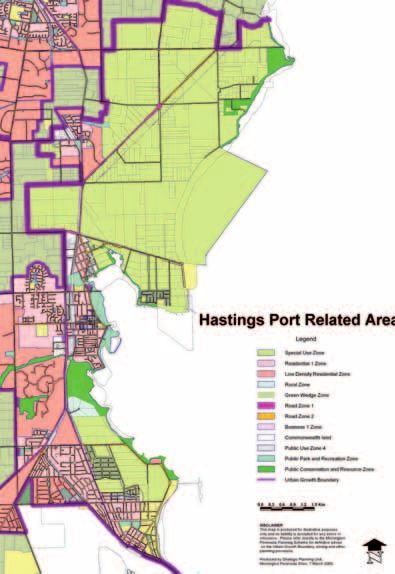
Contents
Section A – Context                                   3
 Background                                            4
 New State and National Infrastructure Priorities      4
 The Western Port Environment                          6
 Port of Hastings Corporation                          6
 Development of the PLUTS                              6
 Objectives of the Strategy                            7
 Planning Principles                                   9
 Existing Land Uses                                    9

Section B – The Strategy                              13
 Port Land Use & Development Strategy                 14
 Overview                                             15
 Long Island Precinct                                 16
 Staging of Development in the Long Island Precinct   16
 Crib Point Precinct                                  21
 Stony Point Precinct                                 24

 Port Transport Strategy                              25
 Overview                                             26
 Road Access                                          27
 Rail Access                                          30
 Corridor Planning                                    34

Section C – Approach to Implementation 37
 Approach to Strategy Implementation                  38
 Overview                                             38
 Sustainable Port Concept                             38
 A Sustainable Port of Hastings                       39
 Environmental Management                             40
 Community Engagement                                 42
 Economic Impact                                      43
 Land Use Planning                                    43

                                                           I 1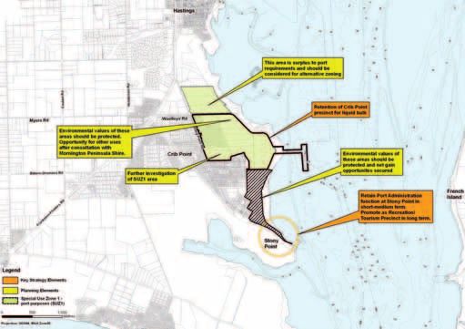
2I

SECT ION A
     Context

               I 3
New State and
Background                                                        National Infrastructure Priorities

The Port of Hastings is located approximately 30km south          The Victorian Transport Plan and Freight Futures
east of the Melbourne suburb of Dandenong and is one of
4 major commercial trading ports operating in Victoria. Each      On 8 December 2008, the Victorian Government released
year around 4 million tonnes of petroleum product (oil and        The Victorian Transport Plan (VTP) and Freight Futures –
gas) is handled through the State-owned jetties at Crib Point     Victorian Freight Network Strategy.
and Long Island Point, with a further 1 million tonnes of steel   The VTP sets out the Government’s vision and plans for
product handled through the BlueScope Steel wharves.              developing an integrated, sustainable transport system
In November 2004, the Victorian Government released the           for Victoria over the next 20 years.
Victorian Ports Strategic Framework (VPSF) to provide high        The VTP has identified the Port of Hastings development
level strategic guidance for the long term development of         (Stage 1 – new multipurpose berths in the Long Island
Victoria’s ports system. The VPSF identified Hastings as a        precinct) as a state prioritised project and proposes
port suitable for expansion into international container trades   to conduct:
to complement the Port of Melbourne, once Melbourne
reaches capacity. Growth projections for international              “…preliminary environmental studies of the proposed
container trade suggest that Melbourne’s capacity could             port area, to inform a strategic environmental assessment
be exhausted by around 2030 and that there is a need                of the long term development of the port and also design
for additional capacity in Victoria to service the expected         works, to be completed by 2012.”
overflow from Melbourne.                                          Freight Futures is the Victorian Government’s long term
The VPSF has provided sound strategic and governance              strategy to ensure that the State’s freight networks, systems
arrangements and has enabled participants in the port             and infrastructure are planned and developed to continue
system to plan their operations and investments with              performing well to meet the existing and future freight tasks.
confidence. Many of its actions have been completed or            Freight Futures forms an important companion document
well progressed, including delivery of this Port of Hastings –    to the VTP and elaborates the Government’s thinking in
Port Land Use and Transport Strategy (PLUTS).                     relation to freight.
                                                                  Freight Futures identifies a Principal Freight Network (PFN)
                                                                  of key transport (road, rail, sea and air) corridors which
                                                                  link the Freight Activity Centres (FACs), particularly those
                                                                  of national, state and regional significance. Freight Futures
                                                                  recognises ports as particularly important FACs with special
                                                                  attributes and needs and sets out a range of actions to
                                                                  ensure their ongoing efficiency and sustainability.
                                                                  Freight Futures elaborates on the actions required to
                                                                  develop the Port of Hastings – Stage 1:
                                                                    “…continue to plan for the delivery of new port capacity
                                                                    at Hastings in the timeframes required and in a
                                                                    manner that is sustainable and meets the highest
                                                                    environmental standards…
                                                                    …commence detailed environmental benchmark
                                                                    studies and initial concept designs in preparation for
                                                                    formal environmental impact assessment processes
                                                                    for development of the Port of Hastings…
                                                                    …plan for the timely and sustainable delivery of new
                                                                    port capacity at Hastings, including commencement of
                                                                    detailed planning and design for a Stage 1 multi-purpose
                                                                    berth development…”

4 I
Port Futures                                                      Infrastructure Australia
Port Futures advances new directions outlined in the VTP and      In 2008, Infrastructure Australia (IA) identified the following
Freight Futures and updates aspects of the existing settings      key challenges facing Australia, which are relevant to ports:
in the VPSF, including the sequence of port development
                                                                  • Supporting our cities – Improving the liveability,
and improvements to port governance arrangements.
                                                                    sustainability and productivity of Australia’s major cities.
The goal of Port Futures is to introduce improved policy and
                                                                  • Boosting exports – Increasing the productivity of
strategy settings to ensure that the contribution of Victoria’s
                                                                    Australia’s international gateways, making sure that
ports to the State’s economic prosperity and sustainability is
                                                                    they can meet the rapidly growing freight task without
maintained and maximised.
                                                                    adverse impacts on community amenity.
Port Futures addresses the following key issues of particular
                                                                  • Supporting rural communities – Improving the
relevance to the Port of Hastings:
                                                                    quality of life and economic prosperity in rural and
• Port Governance arrangements – Freight Futures                    regional communities.
  flagged the Government’s intention to integrate the
                                                                  In May 2009, the Australian Government and IA announced
  ports of Hastings and Melbourne. Port Futures develops
                                                                  nine Priority Projects to commence immediately and a
  the policy rationale for this port governance change and
                                                                  further twenty-eight Priority Infrastructure Pipeline projects
  sets out the next steps in implementation.
                                                                  which should proceed to more detailed design development
• Port Planning and Protection – Port Futures provides the        prior to investment. The development of the Port of Hastings
  context for the release of the port land use strategies for     is a priority pipeline project.
  all four commercial trading ports; the requirement that
                                                                  As Melbourne is Australia’s largest container port, planning
  they be updated regularly on a four yearly cycle; and the
                                                                  for long term growth in container trades is critically important
  proposal that they be appropriately recognised in the
                                                                  to Australia’s productivity.
  Victoria Planning Provisions. It also contains a range of
  proposed initiatives to streamline planning processes           From around 2020, it is expected that more room will be
  within and around ports.                                        needed for containers at Melbourne. Hastings will need
                                                                  to accommodate some cargo currently passing through
• Port Safety, Security and Environmental Performance –
                                                                  Melbourne. It is proposed that this displaced trade will be
  Port Futures builds on improvements in safety, security
                                                                  facilitated by Stage 1 of the Hastings development.
  and environmental risk management by giving effect
  to the recommendations of the Review of Pilotage
  Arrangements in Victoria; committing to a full response
  to issues identified in the Marine Emergency Framework
  Review; and undertaking a review of the implementation
  and operation of port Safety and Environment
  Management Plans (SEMPs). Port Futures also identifies
  the priorities for ports in adapting to the challenges
  presented by climate change and increasing community
  expectations on sustainability issues for ports.

                                                                                                                                I 5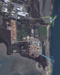
The Western Port Environment                                     Port of Hastings Corporation

Western Port covers an area of approximately 680km2              The Port of Hastings Corporation (PoHC) is a Victorian
and includes two islands, French Island and Phillip              statutory corporation established in 2004 under the terms
Island, which lie at the centre and entrance of the bay          of the Port Services Act 1995. PoHC is responsible for
respectively. Approximately 40% of its total area is exposed     developing and managing the port in an economically,
mudflat at low tide. Net water flow in Western Port is           socially and environmentally sustainable manner, ensuring
primarily in a clockwise direction around French Island with     that essential port services are available and cost effective
the majority of water exchange with Bass Strait through          and, in cooperation with other relevant responsible bodies,
the western entrance, due to its greater width. Freshwater       ensuring the sustainable growth of trade through the Port
inflow to Western Port comes via 17 waterways which              of Hastings.
drain the catchment. The Bunyip, Bass and Lang Lang
Rivers are the major inflow points, together contributing
approximately 75% of the freshwater inflow.
Western Port is an area of ecological importance; it contains
a vast range of marine life and provides roosting and feeding
areas for waterbirds. The bay is listed under an international
                                                                 Development of the PLUTS
treaty – the Ramsar Convention on Wetlands – and is
included on the convention’s List of Wetlands of International   The Victorian Government released the VPSF in 2004,
Importance. Western Port contains three Marine National          identifying the Government’s plan for the role and
Parks and five Special Management Areas. Native vegetation       development of the Port of Hastings.
and habitat are widespread within the SUZ1 port related
                                                                 In cooperation with the then Victorian Department of
zone and vary from local to international significance.
                                                                 Infrastructure (now the Department of Transport – DoT),
The Western Port Ramsar wetland is a wetland of                  POHC prepared a draft Port of Hastings Land Use &
international significance, encompassing the whole of            Transport Strategy. The draft was exhibited between October
Western Port to the north and east of Phillip Island. The        2006 and March 2007 and community feedback informed
Western Port area was designated as a Ramsar site in 1983        the development of the Proposed Port of Hastings Land
and the area is also listed on the Register of the National      Use & Transport Strategy. PoHC submitted the proposed
Estate (2005).                                                   Strategy to the Victorian Government for its consideration
                                                                 in December 2007.
Western Port is also within the area defined as the
Mornington Peninsula and Western Port Biosphere Reserve.         The Victorian Government has since reviewed PoHC’s
The area (including the Port of Hastings) was designated         proposal and developed a formal response that broadly
under UNESCO’s Man and the Biosphere program in 2002,            supports the planning framework set out in the proposed
joining a network over 400 Biosphere Reserves in more            strategy and provides the context for port development in
than 100 countries. The reserve includes the whole of the        light of recent state and national priorities.
Mornington Peninsula Shire, parts of the City of Frankston,
                                                                 This final Port Land Use & Transport Strategy (“the PLUTS”)
and coastal areas of the municipalities of Casey, Cardinia
                                                                 document reflects these recent policy developments and
and Bass Coast including French and Phillip Islands.
                                                                 sets out the staged development of land and water based
                                                                 infrastructure required for the port of Hastings to meet its
                                                                 projected future trade demands.
                                                                 The Port of Hastings Land Use & Transport Strategy will
                                                                 be reviewed and updated every four years.

6 I
Figure 1: PLUTS development process Objectives of the Strategy
The overall objective of the PLUTS is to establish a
November 2004
Victorian Ports Strategic Framework comprehensive framework and process for enabling the
identifies Hastings for future development timely and sustainable expansion of the Port of Hastings.
The PLUTS framework aims to provide guidance for project
development and implementation, including consultation
Dec 2005 with agencies and the local community; environmental
PoHC develops Hastings land use and transport access options appraisal; port interface management; the development
approvals process; and, ultimately, infrastructure provision.
Specific objectives of the PLUTS are to:
Dec 2005 – Mar 2006
First phase of Community Consultation on land use and transport • Establish a vision for land use planning in, and transport
access options (90 submissions received)
access to, the Port of Hastings over the next 30 years;
• Establish a clear strategic land use plan and land
Sept 2006 management policy and communicate them
Consultant prepares Port of Hastings Land Use and Transport
effectively to port customers, stakeholders and the
Strategic Study (Final Report)
neighbouring community;
• Define and implement suitable land use designations
Sept 2006
throughout the port area to provide certainty of land
PoHC and the Victorian Government releases
Port of Hastings Land Use and Transport Strategy: Consultation Draft use in the future;
• Identify suitable road and rail transport options to
efficiently and cost effectively link the port to key
Oct 2006 – Mar 2007
Second phase of community consultation and public exhibition regional industrial hubs and the broader State and
(521 submissions received) national freight and logistic networks;
• Ensure that appropriate areas of land and transport
corridors are preserved to cater for the future
Sept 2007
development of the port and associated uses;
PoHC releases Community Consultation Feedback Report
• Effectively integrate planning and development for
the port with the social, economic and environmental
Dec 2007 influences on the surrounding areas; and
PoHC submits Proposed Port of Hastings Land Use & Transport
Strategy to the Victorian Government • Identify the necessary actions and appropriate
staging approaches to achieve the strategic vision.
Dec 2008
Victorian Government releases Victorian Transport Plan (VTP)
and Freight Futures providing a coordinated and integrated
approach to transport and freight planning in Victoria
August 2009
Victorian Government releases Victoria’s new port strategy,
Port Futures and the Government Response to the
proposed PLUTS 2007
PoHC and the Victorian Government release
the final Port of Hastings PLUTS
I 78 I
Planning Principles                                               Existing Land Uses

A set of planning principles for the PLUTS were developed         The Port of Hastings is located within an area that has been
and agreed on by the Project Steering Committee in                set aside under the Mornington Peninsula Planning Scheme
consultation with the Community Reference Group (CRG)             for port related uses, Special Use Zone 1 (SUZ1). Within this
and the Technical Working Group (TWG), formed to help             zone, BlueScope Steel and Esso have significant existing
formulate the PLUTS.                                              uses protected by legislation. (Western Port Development
                                                                  Act 1967 and the Western Port Steelworks Act 1970). Around
The agreed planning principles are:
                                                                  400 ha of the BlueScope area contains a parcel known as
• To protect the future potential for the Port of Hastings        the “Tyabb Reclamation Area” which is actually within the
  to accommodate port operations; container handling              waters of Western Port adjacent to the BlueScope plant.
  facilities; bulk, break bulk, liquid and automotive trades;     This area was identified for reclamation in the early 1970’s
  and related port development once development                   by then owners John Lysaght Pty Ltd who intended the area
  capacity at the Port of Melbourne is reached. (In line          for the development of a steel production plant. This project
  with the Government’s vision outlined in the VPSF 2004);        did not eventuate and the area has not been reclaimed.
• To plan and develop the Port of Hastings to become              The bulk of the area designated as SUZ1 is farm land with
  a model “sustainable” commercial port, integral with            some rural residential and a number of small to medium
  Victoria’s maritime, road and rail freight logistics network;   size commercial operations.
• To plan the port’s layout in accordance with sustainable
  and best practice principles (environmental, land use,
  freight efficiencies, transport access);
• To adopt an integrated system based approach to
  economic, social and environmental assessment
  and management for all aspects of port planning,
  development and operations;
• To develop the port showcasing “green” technologies
  and international best practice in marine and
  terrestrial environmental management and community
  involvement and to recognise the environmental and
  cultural heritage values of the port of Hastings, including
  the Western Port Ramsar Wetlands;
• To implement land use frameworks which can balance
  the port’s operational and efficiency needs with the
  need to protect the amenity and natural environment
  of the surrounding area and provide clear guidance to
  existing and potential port users, the community and
  regulators; and
• To provide transport access to the port via both road
  and rail links to regional and local freight and logistics
  hubs and networks across Victoria.

                                                                                                                            I 9
Image 1: Aerial Photo of Port Facilities
LEGEND
BlueScope Steel Wharf
Long Island
Crib Point
Stony Point
10 IMap 1: Hastings Port Related Area
LEGEND
Special Use Zone
Residential 1 Zone
Low Density Residential
Rural Zone
Green Wedge Zone
Road Zone 1
Road Zone 2
Business 1 Zone
Commonwealth Land
Public Use Zone 4
Public Park and Recreation Zone
Public Conservation and Resource Zone
Urban Growth Boundary
Disclaimer This map is produced for illustrative
purposes only and no liability is accepted for any
errors or omissions. Please refer directly to the
Mornington Peninsula Planning Scheme for definitive
advice on the Urban Growth Boundary, zoning and
other planning provisions.
Produced by Strategic Planning Unit, Mornington
Peninsula Shire, 7 March 2005.
0.0 0.3 0.6 0.9 1.2 1.5km
I 1112 I
SECT ION B
     The Strategy

                    I 13
Port Land Use
& Development
Strategy
14 IOverview
This Port of Hastings Port Land Use & Transport Strategy The Crib Point precinct, further to the south, is adjacent
(“the PLUTS”) utilises the concept of ‘port precincts’, to the Crib Point Jetty and will continue to be used as a
which provide a geographical and functional focus for the liquid berthing facility. However, there is capacity to reassess
areas earmarked for future port operations and staged the current SUZ1 zoning in this precinct to consider the
development. Three precincts are identified – Long Island, total area devoted to port uses. This PLUTS suggests
Crib Point and Stony Point – each with a particular role that there may be scope for community, recreational and
within the Strategy. environmental uses for some of this area. The areas of
State owned land between Crib Point and Stony Point are
The PLUTS focuses future development of the Port of
identified for environmental rehabilitation and management
Hastings on the Long Island precinct, an area to the
in conjunction with local groups, Mornington Peninsula Shire
north east of Hastings township, around Long Island Point.
and relevant government agencies.
This area contains existing facilities serving Esso and
BlueScope Steel and includes the largest contiguous parcel The Stony Point precinct, located at the southern
of Special Use Zone land, providing adequate space for extremity of the port and adjacent to the Stony Point
future development of container handling and other port Jetty, is currently used as the port operations centre. It
infrastructure. Long Island will be the preferred location for a is anticipated that this precinct will become available for
new port operations centre and will become the focal point community, tourism and recreational uses, including a
for future port activity. continuation of passenger ferry services and potentially,
a car ferry service. Management of Stony Point may be
Long Island is some distance away from the residential areas
devolved to the Mornington Peninsula Shire, Parks
of Tyabb and Hastings and the port-related SUZ1 provides
Victoria or other appropriate entities subject to further
approximately 2000 hectares of land, which, once developed,
planning considerations.
can be readily connected by road and rail infrastructure with
minimal impact to the residential population. This PLUTS recognises the economic, social and
environmental issues surrounding a development of the
Road access to the precinct can be achieved by upgrading
scale proposed and therefore provides for a comprehensive
the existing McKirdys Road corridor, without the need for
process of assessment and approvals prior to commencement.
trucks to enter the Hastings township, linking directly to the
The development approvals process will allow for public
Western Port Highway and the Monash Freeway beyond.
inputs during assessments. It is anticipated that each
Rail access can be accommodated in the short term by stage of port development will require the preparation of
extending existing spur lines and then connecting with the an Environment Effects Statement (EES) addressing the
Stony Point to Frankston line. Ultimately the port can be specific effects of that stage as well as the strategic issues
connected via a new corridor exiting parallel to McKirdys relevant to future stages of port expansion.
Road to Dandenong and, if warranted, to Gippsland in the
long term.
To accommodate the expected growth in trades over
the next 30 years it is proposed that port infrastructure
in this precinct be developed progressively as freight
demands justify expansion. Three stages of development
are proposed, with Stage 1 providing for bulk, break bulk,
cars and general cargo (including the potential for some
Bass Strait trade); Stage 2 accommodating international
containers; and Stage 3 providing additional capacity by
physically integrating and expanding facilities constructed
at Stage 1 and Stage 2.
I 15Long Island Precinct
Long Island has been identified as the logical location Stage 1 – 2010 to 2020
for major port expansion. The area is currently used by
BlueScope Steel and Esso-BHP Billiton, is adjacent to Undertake detailed planning to prepare for the reclamation
existing berthing facilities (BlueScope Steel Wharves and of land on the “Old Tyabb Reclamation Area” between the
Long Island Point Jetty) and is close to the deep water existing shoreline and the channel. Dredge berth pockets
channel. The area zoned SUZ1 is more than 2000 ha in and swing basins and use spoil for the adjacent land fill.
total with around 500 ha currently occupied. The bulk of the Develop a multi purpose berthing facility comprising up to
precinct is some distance from the major residential centres 3 berths of approximately 300m each, capable of taking
of Hastings and Tyabb and there is potential to provide road bulk, cars, general cargo and break bulk trades. Connect
and rail access without compromising the amenity of the Stage 1 to existing rail spur lines to connect with the Stony
urban areas. Point rail line, enhance the local road connectivity and
provide premises for a Port Operations facility.
The precinct contains two areas of particular significance
for port development; the “Tyabb Reclamation Area” and the
“Old Tyabb Reclamation Area.” The former is approximately
400 ha in size, has previously been set aside for reclamation
and presents as the ideal space with appropriate
reclamation to establish international container handling Image 2:
and berthing facilities. The latter is an area of reclaimed Long Island Precinct Aerial Close Up
land within 50m of the channel and in close proximity to (focussing on the Old Tyabb Reclamation Area, with the Tyabb
existing road and rail. With additional reclamation of the Reclamation Area extending to the north of the BlueScope Jetty)
area between the existing shoreline and the channel, this
area is suitable for general purpose berth infrastructure to
accommodate bulk, break bulk, cars and general cargo.
Staging of Development
in the Long Island Precinct
As trade demand grows progressively over time, new
port infrastructure can be developed in stages to meet
the demand for new facilities. Each stage will be subject
to environmental approvals and business case analysis
before proceeding. Three stages of port development
are proposed along with indicative timing to meet the
expected demand forecasts:
LEGEND
BlueScope Steel Wharf
Long Island
16 IStage 2 – 2020 to 2035 Stage 3 – Post 2035
Commence detailed planning for the reclamation of the To cater for trade requirements post 2035, Stages 1
“Tyabb Reclamation Area” to the north of the BlueScope and 2 would be expanded and integrated. Two possible
Jetty, developing a series of container berths and land approaches have been identified: a linear continuous
side works to accommodate international container trade. wharf face parallel to the shore line and main channel,
Dredging of berth pockets and swing basins will generate or a partial dock berthing area comprising three distinct
fill for adjacent reclamation of land. berth faces to join Stages 1 and 2.
Prior to this time, a decision will need to be made about These three stages would be implemented subject to
a preferred berthing configuration (eg. land-backed funding considerations and satisfactory completion of
container terminal or offshore island). design and planning processes, including consents
and approvals required under the Commonwealth and
State legislation. (Environment Protection and Biodiversity
Conservation Act 1999 (Commonwealth), Planning &
Environment Act 1987, Coastal Management Act 1995,
and, Environment Effects Act 1978 (Victorian).
Map 2: Long Island Precinct – Staging of Development
LEGEND
Key Strategy Elements
Planning Elements
Special Use Zone 1
– port purposes (SUZ1)
Stage 1 Infrastructure Development
Stage 2 Infrastructure Development
Stage 3 Infrastructure Development
0 500 1000 metres
I 17Actions Required
The development of port infrastructure in the precinct will Berth construction will require land fill and, where
provide for a range of trade types, with the majority of the practicable, all dredge spoil from the construction of berth
area ultimately devoted to the overflow of international pockets and swing basins is to be retained for adjacent
containers from the Port of Melbourne. The development land reclamation. Reclamation areas are to be confirmed
will be adjacent to the existing facilities of Long Island for structural capability prior to construction.
Point (liquid berth) and BlueScope Steel wharves (general
Any development in Stage 1 needs to be cognisant of
purpose and Roll on – Roll off berths).
the adjacent Esso Major Hazard Facility and the Esso
Zoning of the area is currently SUZ1 or Public Use Zone hazard zone.
(PUZ7). It is proposed that this be retained or appropriately
Areas of environmental, cultural and heritage significance
modified to accommodate the proposed development.
will be identified and treated in accordance with existing
Alternatively a “Comprehensive Port Development Zone”
policy provisions.
could be considered.
The application of a revised or strengthened Special Use
Infrastructure proposed includes multi-purpose berths in the
Zone or the creation of a Comprehensive Port Development
south and container terminal berths to the north with a final
Zone at the Long Island precinct will ensure that approval
dock style or continuous berth to connect the two. Provision
processes are straight forward and consistent with any
for road and rail access can be achieved in the first instance
performance measures established for the zone.
by extending existing rail spur lines and ultimately providing
new road and rail services to the north, exiting the port It is proposed that the Old Tyabb Reclamation Area
precinct via an upgraded corridor along the alignment of be transferred from the Department of Sustainability
McKirdys Road. and Environment (DSE) to PoHC to provide for Stage
1 development to take place. For Stage 2 and Stage
Landside infrastructure will include areas for hard stand,
3 developments, land will need to be acquired from
storage and handling yards, associated logistics operations
BlueScope Steel Pty Ltd.
and a new port operations facility.
18 ITable 1: Actions – Long Island
Action Development Stage
Transfer “Old Tyabb Reclamation Area” (CA76L) from DSE to PoHC. Stage 1
Negotiate sale and transfer of land from BlueScope Steel to PoHC following survey and confirmation
of long term needs of BlueScope Steel. (Including the “Tyabb Reclamation Area” and the Tyabb Stage 2
foreshore area.)
Progressively design and subsequently develop Long Island precinct facilities to accommodate
container related trade as well as provide a multi-purpose capacity (to accommodate bulk, break Stages 1, 2 & 3
bulk and motor vehicles).
Ensure adequate back up land is available beyond Long Island Point terminal areas for world class
cargo handling facilities, container support activities and efficient transport and logistics connections.
Stage 2
Provide additional swing basins and berth pockets adjacent to new berthing infrastructure, using spoil
to accommodate adjacent land fill.
Stages 1, 2 &3
Retain the existing Port Waters of the Port of Hastings, and ensure that any new access channels,
anchorages, swing basins and berthing pockets are clearly defined and identified.
Stages 1,2 & 3
Progress more detailed investigations to select the port layout options where marine and terrestrial
environmental impacts can be avoided, minimised or mitigated.
Stages 1, 2 & 3
Undertake environmental assessments to identify net gain opportunities for marine, coastal and
terrestrial environments.
Stages 1, 2 & 3
Identify and protect all rail and road access easements within the port precinct. Stage 2
Protect areas of heritage significance. Stages 1,2 & 3
Retain the existing Special Use Zone 1 (SUZ1) zoning buffer provisions to protect port operations,
infrastructure and future development potential, sustainability and the interface with surrounding land uses.
Stages 1, 2 & 3
Identify and incorporate the Esso Hazard Zone into planning for the “Old Tyabb Reclamation Area”
and parcels to the west of the Esso facilities.
Stage 1
Protect and enhance areas of marine coastal and terrestrial environmental significance, in particular
protect the marine National Parks within Western Port, the existing “Land for Wildlife” areas adjacent to Stages 1, 2 & 3
BlueScope Steel
Redefine the SUZ1 specifications or establish a “Comprehensive Port Development Zone” (CDZ) around
the Long Island Precinct (as identified in Long Island Land Use Strategy for Stage 1, 2, 3 development)
to allow for long term certainty of port development. Develop criteria to support the SUZ1/CDZ decision
process allowing port development approvals within the Zone.
Stages 1, 2 & 3
Retain existing land zoned SUZ1 at Long Island Precinct outside of any redefined SUZ1/CDZ.
Ensure all other land not zoned SUZ1 within port precinct is appropriately zoned for port purpose,
e.g. CDZ, SUZ1, PUZ4 or PUZ7.
If necessary identify and protect any other land required for port precinct, berth infrastructure and
landside uses through an appropriate planning scheme development overlay.
Stages 1, 2 & 3
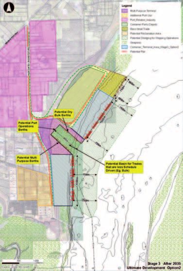
I 19The following map provides a conceptual layout of a possible ultimate development
configuration within the Long Island precinct. It is recognised that further detailed assessment
and design will required to confirm ultimate dimensions and layouts.
Map 3: Layout concept for an ultimate Long Island Precinct (Post 2030)
LEGEND
Multi Purpose Terminal Seagrass
Additional Port Use Container Terminal Area
Port Related Industry Stage 3 Option 2
Container Parks Depot Potential Rail
Bass Strait Trade Potential Roads
Potential Reclamation Area Bathymetry
Potential Dredging for Shipping Channel
Shipping Operations
20 ICrib Point Precinct
The Crib Point precinct is located south east of Hastings While retention of the liquid berthing facilities is essential,
and is close to the residential areas of Crib Point township. as already noted, the majority of port related development
The Crib Point Jetty liquid berth facilities and the former will be located to the north at Long Island. One of the key
BP refinery site are strategically important assets for the advantages of this approach is to secure appropriate buffers
State of Victoria. and separate port industrial development and related
transport activities from residential and other sensitive uses.
Crib Point has an existing pipeline connection to Long
Future developments at Crib Point should aim to reinforce
Island and the Western Port Altona Geelong (WAG) pipeline.
this approach. Exploring opportunities for alternative uses of
Current operations at Crib Point include the import of
port zoned land which complement the efficient and effective
unleaded petrol for transport via pipeline to the United
operation of the port provides some scope to review and
Terminals storage and distribution facility at Hastings and
investigate the areas of port related zoning near Crib Point
‘ship to ship’ transfer operations for Roc Oil (transfer of
and consider the potential to include conservation, recreation,
crude oil from one vessel to another at a safe berth).
rural, and public uses.
Image 3: Crib Point Jetty Close Up In particular, while retaining the SUZ1 around the old BP
Refinery site, there is an opportunity to review the SUZ1
designated areas to allow for other uses that may be
compatible with port operations. An exploration of alternative
uses of port zoned land should be based on a thorough
analysis of future potential uses, including port related use,
and undertaken in conjunction with the Mornington Peninsula
Shire Council (MPSC), the Department of Innovation Industry
& Regional Development (DIIRD) and the Department
of Planning and Community Development (DPCD). This
exploration and consultation should form part of a coordinated
approach to overall planning for the area between Crib Point
township and the Crib Point Jetty.
Areas to the north of Wooleys Road are considered to be
surplus to port requirements and should be investigated for
alternative zoning.
Declared Port Land There is also an opportunity to protect and rehabilitate
environment and conservation values on State owned land
between Crib Point and Stony Point. It is proposed that
This PLUTS proposes that the Crib Point precinct continue management and ownership arrangements for this land,
to focus on servicing liquid bulk trades, recognising the currently owned by DSE and Department of Treasury and
strategic importance of the natural deepwater access to Finance, be reviewed.
berths at Crib Point Jetty.
It is proposed that subject to this review occurring, PoHC
Operations at Crib Point should retain the current focus on would, in conjunction with DSE and the Mornington
liquid product. Peninsula Shire Council (MPSC), undertake an environmental
Zoning of the Crib Point Jetty access area, within the audit of the area prior to establishing a local environment
ownership of PoHC, is currently a mixture of PUZ7 (Public management plan. The land could be transferred to PoHC,
Use Zone-other uses) and PCRZ (Public Conservation and managed by PoHC or, alternatively, managed through
Resource Zone). As this parcel is the only foreshore access a Committee of Management with local
point for port uses available at Crib Point it should be wholly community involvement.
zoned for port uses as PUZ7. Some areas across the road
from the jetty, in particular the old BP Refinery site, should
be retained as SUZ1 due to the strategic importance of the
connections to the liquid berth, bulk liquid storage
facilities and the WAG pipeline.
I 21Table 2: Actions – Crib Point
Actions Stage
Retain Crib Point Jetty and jetty access areas as a liquid bulk terminal and secure PUZ7 zoning
Stage 1
for the whole of the jetty access area.
Progress the establishment of appropriate transport corridors in conjunction with relevant State
Stage 1
and local government agencies
Protect and rehabilitate areas of marine and terrestrial environmental significance, in particular
Stage 1
protect the existing Crib Point-Stony Point foreshore.
Retain the strategically important areas around the former BP Refinery site at Crib Point as Special
Use Zone 1 (SUZ1) to provide potential capacity to accommodate liquid trades which require
deep water access (15m+) and land backing.
Stage 1
Recognising that there is potential to review some of the SUZ1 zoning in this location to
accommodate alternative land uses in the future, participate in an exploration of future
potential uses with MPSC, DIIRD and DPCD.
Retain SUZ1 buffers between sensitive uses and the Port and areas at Crib Point, and adjacent
Stage 1
industrial areas, particularly the buffers to local residential areas.
Investigate rezoning of SUZ1 land north of Wooleys Road. Stage 1
Review management and ownership arrangements for land between Crib Point and Stony Point
currently owned by the State.
Stage 1
Undertake an environmental audit and prepare an environment management plan (to include
net gain evaluation) for this area.
22 IMap 4: Crib Point Precinct
LEGEND
Key Strategy Elements
Planning Elements
Special Use Zone 1
– port purposes (SUZ1)
0 500 1000 metres
I 23Stony Point Precinct Image 4: Stony Point Jetty Close Up
Located at the end of Stony Point Road adjacent to
the Stony Point–Crib Point foreshore and associated
recreational facilities, the PLUTS recognises Stony Point’s
potential to provide for development of tourism and
recreational uses.
The current PUZ7 (Public Use Zone 7) focuses on
the existing use of Stony Point as the location for
port operational activity with office and workshop
buildings and the jetty. PoHC owns the site and the jetty
infrastructure. The jetty is currently divided into public
access (providing passenger ferry services to French
& Phillip Islands) and port operations sections.
With the proposed relocation of port operations to the
Long Island precinct, there is scope to review the long
term use of Stony Point. Current public access is via
Stony Point Road and there is already significant public
use of the area.
The PLUTS proposes that future uses could retain the
current passenger ferry services but could also include a
car ferry between Stony Point and Cowes, additional boat
launching facilities, tourism facilities (café, information
centre, etc).
It is proposed that in the medium to long term these
assets could be transferred to DSE/Parks Victoria or the
Mornington Peninsula Shire. Alternatively, should a car
Declared Port Land
ferry operation proceed, PoHC could retain ownership
and lease the facilities for that purpose, ensuring that
there are publicly accessible facilities developed as part
of a car ferry operation.
Table 3: Actions – Stony Point
Action Stage
In the short term, retain port administration uses in the Stony Point precinct, and then relocate
to the main port precinct as part of Stage 1 development at Long Island precinct.
Stage 1
Retain and enhance public access to the coastal area where safely possible. Stage 1
Promote recreation and tourism uses in the Stony Point precinct. Stage 1
Support the development of the proposed Stony Point to Cowes car ferry from Stony Point. Stage 1
In the long term, consider ownership and management arrangements for the precinct to
encourage development of new community activities and uses.
Stage 2
24 IPort Transport
Strategy
I 25Overview
Providing effective transport access to and from the Port All road corridor options considered for this Transport
of Hastings is an essential element of planning for port Strategy utilise existing road corridors or existing road
development. In 2008, the Victorian Government released corridor reservations. Key routes have been earmarked
The Victorian Transport Plan and Freight Futures, both of for upgrading by VicRoads. As forward planning for these
which identified the Port of Hastings as key freight activity upgrades has included reservations for any future widening
centre on the Principle Freight Network (PFN). The PFN is or duplication of carriageways, no new road corridors are
part of a larger transport network over which the movement required. In particular, the Western Port Highway is identified
of freight will be encouraged. as the primary road freight corridor to connect the port to
the Victorian road network.
Currently the port is connected to the broader transport
network by rail (Stony Point Line) and via local and regional Rail connection to Hastings is currently via the Stony Point-
road networks. With increased activity at the port these Frankston line. This line has limitations that will need to be
existing networks will need to be expanded and upgraded addressed to accommodate increased freight movements
to ensure effective ongoing access to the Victorian over the short to medium term. In the longer term, a new
freight and logistics network. The transport system rail corridor will be needed to connect Hastings with the
needs to provide good linkages within the local port area industrial and manufacturing areas around Dandenong
and between the port and key intrastate and interstate and beyond to Melbourne. Ultimately, a connection with
destinations, including via the proposed Metropolitan Gippsland may also be required to accommodate bulk and
Freight Terminal Network (MFTN) outlined in Freight Futures. break bulk trades and this will need to be taken into account
in selecting a preferred long term rail corridor.
Importantly and consistent with the PoHC desire to
effect a sustainable port which maximises the use of rail Three major new rail corridor options for the long term
transportation, the Port Transport Strategy (“the Transport link were identified in developing the Transport Strategy
Strategy”) has set a mode share ‘stretch’ target of 50% for – the Port Phillip Corridor, the Western Port Corridor and
rail and 50% for road (excluding commodities transported the Gippsland Corridor. However, further assessment is
by pipeline). required before a preferred option can be determined for
detailed consideration. This would include consideration of
A key objective of the Transport Strategy is to identify
environmental assessment, land ownership and acquisition
suitable road and rail transport options from the Port
issues, impacts on existing urban and rural activities and
of Hastings to various industrial hubs around Victoria
long term protection within relevant planning schemes.
and interstate destinations, in order to ensure adequate
At this stage, providing it proves technically feasible to
integration of the port with the Victorian and national freight
construct a potential eastward connection to Gippsland at
and logistics network.
the northern end of the Port Phillip and/or the Western Port
The Port of Hastings is currently connected to the broader Corridor, the Gippsland Corridor is not favoured to proceed
Victorian road network by a number of single-carriageway as the preferred option. However, if significant bulk freight
roads that provide suitable capacity for existing traffic demands emerge from Gippsland, further consideration
flows. These roads service a variety of land uses along their will be given to identifying a more suitable alignment to
length, including residential, rural residential, industrial and Gippsland from Melbourne.
commercial areas.
26 IRoad Access
Regional Access (see Map 5)
This Transport Strategy proposes that the primary road to accommodate predicted traffic flows post 2030. Any
access route to the expanded port will be the Western Port future planning work by VicRoads and DoT should include
Highway linking Hastings with Dandenong and Melbourne’s allowance for future port related traffic.
south eastern suburbs. Development of the Peninsula Link,
Expected volumes of port traffic suggest that elevating the
connecting EastLink and the Mornington Peninsula Freeway
Western Port Highway to freeway standard may be required
will provide an alternative link from Hastings to the broader
in the longer term. Further, associated grade separated
metropolitan road network.
intersections may assist east west movements between
Port connectivity through to Gippsland along the existing Hastings and Dandenong.
road corridors of Tyabb-Tooradin Road, Baxter-Tooradin
While the Western Port Highway is not directly linked to the
Road, South Gippsland Highway and the Koo Wee Rup-
port at present, the developments proposed in Stage 2
Pakenham Road will require some improvements.
will provide a direct link along a redesigned and upgraded
The Western Port Highway will be upgraded to four lanes McKirdys Road.
progressively to accommodate Melbourne 2030 population
Any road access arrangements need to be developed in
growth. VicRoads already has a proposal for development
collaboration with PoHC, the DoT, VicRoads and respective
Table 4: Actions – Regional Road Access local governments.
Action Stage
VicRoads develop Western Port Highway to freeway standard from the north to the
Stages 1, 2 & 3
Tyabb-Tooradin Road.
PoHC support the construction of Peninsula Link. Stages 1 & 2
PoHC encourage improved port connections to Gippsland via the use of Tyabb-Tooradin Road,
Baxter-Tooradin Road, South Gippsland Highway and the Koo Wee Rup-Pakenham Road with Stages 2 & 3
a local bypass of Koo Wee Rup.
VicRoads design and encourage use of appropriate regional east-west freight routes such as
Stages 2 & 3
Thompsons Road and Greens Road to connect to EastLink.
PoHC/DoT/VicRoads to develop strategies which facilitate the establishment of specific
Stages 1, 2 & 3
port-related regional road freight routes (similar to Over Dimensional routes).
PoHC/VicRoads upgrade McKirdys Road to provide direct access to Western Port Highway. Stage 2
VicRoads and local government provide upgrades as required to all preferred transport routes. Stages 1, 2 & 3
I 27Map 5: Regional Road Access
Western Port Road Corridor
Port Phillip Road Corridor Preferred primary road access
Potential medium term road access
Dandenong
Danden Gippsland Road Corridor
Bypass ong P Potential long term alternative
r
Din opo
By gle sed road access
pa y
ss
Berwick
Gippsland Road Corridor
Potential regional east-west Potential long term alternative
Chelsea road freight links road access
East Link
Pakenham
Thomps
ons Rd
Port
Phillip
Hwy
Cranbourne
Potential access options
Port
to Gippsland
Western
Develop Western Port
Hwy to freeway standard
d
Ways R
Frankston
Link
Rup Rd
sula
Five
Penin
St
Clyde -
ee
h
Gi
Koo W
osed
pp
sla
Potential road bypass of
Prop
nd
Koo Wee Rup township required
Hw
y
din Rd
Baxter - Toora
Fra
nk
sto
n-
Fli
nd
ers
Somerville
Rd
Develop Western Port Hwy as a
4 lane divided road to Hastings Western Port
Long Island
Precinct
Potential bypass of Somerville
and Tyabb through use of
Coolart and Graydens Roads
0 5 10km
Stony Point and
Crib Point Precinct
Merricks
Existing road corridor
Potential road corridor option
28 ILocal Access (See Map 7)
In order to secure an access to and from the port that of the suggested link between this main intersection and a
avoids residential areas of Somerville and Tyabb, the new corridor to link at Watts Road will allow for a smooth
Transport Strategy proposes the upgrading of Graydens passage of commuter traffic from Hastings to the north.
Road and Coolart Road.
There is currently a provision for ultimately upgrading Watts
Utilise the existing road reservation and develop the western Road, Hastings to a four lane divided road through to Reid
end of Bayview Road to enable port-related road freight to Parade in the south to provide improved local access.
connect with Western Port Highway.
Diverting freight traffic along this corridor will allow for further
upgrading of the connection of the Western Port Highway
and the Frankston Flinders Road intersection. Development
Table 5: Actions – Local Road Access
Action Stage
PoHC/DoT/VicRoads/Mornington Peninsula Shire to develop strategies which facilitate the
Stages 1, 2 & 3
establishment of specific port-related local road freight routes.
PoHC support the extension of Bayview Road to provide a direct connection with the Western
Stage 1
Port Highway.
PoHC support the proposed connection between the Western Port Highway and Watts Road
(with a grade separation over the Frankston-Stony Point rail line) and initiative for widening Stage 2
of Watts Road through to Reid Parade.
PoHC/DoT/VicRoads/Mornington Peninsula Shire consider local improvements required
to link Hastings with the Mornington Peninsula Freeway corridor and Frankston and to
Stages 2 & 3
avoid existing built-up residential areas (Graydens Road, Coolart Road and part of the
Frankston-Flinders Road).
PoHC support upgrades to all preferred transport routes. Stages 1, 2 & 3
I 29Rail Access
Rail access into the port areas requires upgrading to The assessment methodology, findings and recommended
ensure long term connectivity and to allow for the proposed rail access strategy are outlined in full in the Port of Hastings
50% rail mode share. Stage 1 development will require Land Use and Transport Strategic Study – Final Report
an extension of the existing Stony Point spur line, serving (September 2006) and summarised in the Report on the Port
BlueScope Steel and Esso, to the “Old Tyabb Reclamation of Hastings Land Use and Transport Strategy, Consultation
Area” at the eastern end of Bayview Road. This connection Draft. In summary, the recommended strategy was as follows:
would allow use of the Frankston – Stony Point line capacity
• Preferred Short-term Option – Initial utilisation of available
until a new corridor could be developed. Some progressive
capacity on the existing Frankston-Stony Point corridor
improvements to the Frankston – Stony Point line will be
until such time that capacity is reached
required to improve its operational capacity. These can
be accommodated within the existing rail reserve. • Then upgrading the signalling/safe working arrangements
on the Hastings to Frankston section to allow off-peak
In the longer term, a new corridor will be required providing
freight train operations (medium term)
direct connections to the Dandenong industrial area, the
metropolitan network and, potentially, to Gippsland, as trade • Then, enhancing the capacity of the Frankston-Baxter
demands emerge in that region. The Port of Hastings Land corridor by either providing crossing facilities or duplicating
Use and Transport Strategic Study – Final Report (Maunsell, the Frankston-Hastings section (medium term)
September 2006) identified four possible rail access options • For the long term and to connect the port with the
to the Port of Hastings: Gippsland region, constructing a new rail line from the
1. Frankston-Stony Point Rail Line Port of Hastings along the Gippsland corridor as far as
Clyde, assuming the rail line between Cranbourne and
2. Port Phillip Corridor
Dandenong has been duplicated for suburban capacity
3. Western Port Highway Corridor reasons (post 2020).
4. Gippsland Corridor Possible future expansion options included:
Each option was assessed against the following attributes: • Constructing a new railway from Clyde to Officer
to provide a connection to eastern Dandenong
• Ability to obtain access for required freight train volumes.
and/or Gippsland.
• Access to key freight origins and destinations, as well
• Provide a standard gauge link to the interstate network.
as intermodal terminals. Key locations include
Melbourne, Altona, Somerton, Dandenong, Gippsland The PLUTS consultation from October 2006 – March 2007
and interstate networks. generated over 520 submissions. Feedback from both local
communities and affected Councils pointed to the need
• Potential for a standard gauge link.
for further assessment to be undertaken before a preferred
• Potential for double stack access. Gippsland rail corridor option was determined.
• Community impacts.
• Use of existing rail corridors.
• Expected cost ranges.
30 IDoT subsequently carried out a structured assessment DoT, as the responsible State agency for rail network
of the relative merits of the ‘Western Port Highway’, ‘Port planning will undertake further targeted conceptual design
Phillip’ and ‘Gippsland’ corridor options. The assessment and assessment to provide a more complete basis for
indicated that, while the total estimated cost of constructing comparing the various corridor options in terms of likely
rail in each of the corridors was similar, the community footprint, land purchase cost, construction cost and
impacts were significant on the ‘Gippsland’ corridor. potential impacts.
As a result of this investigation, the Victorian Government
no longer favours the ‘Gippsland’ corridor option, leaving
the ‘Port Phillip’ and ‘Western Port’ corridor options (and
variations of these options) for further consideration.
Table 6: Actions – Rail Access
Action Stage
Regional Rail Connections
DoT to lead further detailed assessment of rail corridor capacities and options and requests
Stage 1
that DoT provide a recommendation to Government on a preferred rail corridor.
For the long term, and to connect the port with the Dandenong & Gippsland regions,
PoHC support planning for a new rail line from the Port of Hastings along a new route to be Stages 2 & 3
established by the Government.
Local Rail Connections
DoT consider provision of a rail line connection from the existing BlueScope Steel/Esso spur
Stage 1
to “Old Tyabb Reclamation Area”.
PoHC support initial use of available capacity on the existing Melbourne-Frankston-Stony Point
Stage 1
Corridor until capacity is reached.
DoT upgrade the signalling/safe working arrangements on the Hastings to Frankston section
Stage 1, 2
to allow off-peak freight train operations (medium term).
DoT enhance the capacity of the Hastings-Frankston corridor by either providing crossing
Stages 1 & 2
facilities at selected locations or by duplicating the entire track length (medium term).
I 31You can also read