Municipal Fire Management Plan 2020-2023
                               Whittlesea
←
→
Page content transcription
If your browser does not render page correctly, please read the page content below
Municipal Fire Management Plan 2020-2023
Whittlesea
Acknowledgements

The Municipal Fire Management Planning Committee acknowledges the contributions of the following
agencies and organisations:
   ▪   City of Whittlesea
   ▪   Country Fire Authority
   ▪   Metropolitan Fire Brigade
   ▪   Department of Environment Land Water and Planning ( DELWP ) formally Department of
       Sustainability and Environment
   ▪   Parks Victoria
   ▪   Victoria Police
   ▪   VicRoads
   ▪   AusNet Services
   ▪   Yarra Valley Water
   ▪   Melbourne Water
   ▪   Department of Health and Human Services
Authorisation and Endorsement

This first edition of the Whittlesea Municipal Fire Management Plan was endorsed by the Municipal Fire
Management Planning Committee in November 2011. Organisations represented on the committee include:
   ▪   City of Whittlesea
   ▪   Country Fire Authority
   ▪   Metropolitan Fire Brigade
   ▪   Parks Victoria
   ▪   Department of Environment Land Water and Planning ( DELWP ) formally Department of
       Sustainability and Environment
   ▪   Victoria Police
   ▪   VicRoads
   ▪   Melbourne Water
   ▪   Yarra Valley Water
   ▪   Department of Health and Human Services

This Municipal Fire Management Plan was also endorsed by the Whittlesea Municipal Emergency
Management Planning Committee in November 2011 and adopted by Council as a sub-plan of the
Whittlesea Municipal Emergency Management Plan in June 2012.

Whittlesea Municipal Fire Management Plan 2020-2023(Version 12)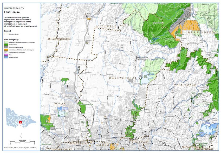
TABLE OF CONTENTS

1      INTRODUCTION AND CONTEXT .................................................................................. 6
       Authority for the plan.........................................................................................................................6
       Purpose of this Plan..........................................................................................................................6
       Membership of Whittlesea Municipal Fire Management Committee ................................................7
       Role of Whittlesea Municipal Fire Management Committee ............................................................7
2      ENGAGEMENT AND COMMUNICATIONS .................................................................... 7
3      ENVIRONMENTAL SCAN .............................................................................................. 8
       City of Whittlesea Profile ..................................................................................................................8
       Fire History .......................................................................................................................................9
       Assumptions (about the future of the municipal district) ...................................................................9
4      MUNICIPAL FIRE MANAGEMENT OBJECTIVES ....................................................... 10
       Plan Objectives .............................................................................................................................. 10
       Alignment to Regional Objectives.................................................................................................. 10
       Strategic Objectives ....................................................................................................................... 10
       Linkages ........................................................................................................................................ 11
5      RISK MANAGEMENT ................................................................................................... 12
       Risk Environments ......................................................................................................................... 12
       Agency Risk Management ............................................................................................................. 13
       Cross Boundary Arrangements ..................................................................................................... 13
6      PLAN REPORTING AND REVIEW ............................................................................... 14
       Plan Endorsement ......................................................................................................................... 14
       Audit ............................................................................................................................................... 14
       Plan Review ................................................................................................................................... 14
7      APPENDICES ............................................................................................................... 15
       A           RISK MANAGEMENT REGISTER .................................................................... 16
                   Risk Description ................................................................................................................ 16
                   Addressing Bushfire Risk ................................................................................................. 16
                   Addressing Structural Risk ............................................................................................... 17
                   Addressing Hazardous Materials Risk.............................................................................. 17
                   A.1 Bushfire Risk Management Register ......................................................................... 17
                   A.2 Structure Fire Risk Management Register ................................................................. 17
                   A.3 Hazardous Materials Risk Management Register ...................................................... 17
       B           MULTI AGENCY WORK PLAN ......................................................................... 18
                   B.1 Bush and Grass Fire Multi Agency Work Plan ........................................................... 18
                   B.2 Structure Multi Agency Work Plan ............................................................................. 18
                   B.3 Hazardous Materials Multi Agency Work Plan ........................................................... 18
       C           STATUTORY AUDIT OBLIGATIONS................................................................ 19
                   C.1 Hazardous Trees ....................................................................................................... 19

Whittlesea Municipal Fire Management Plan 2020-2023(Version 12)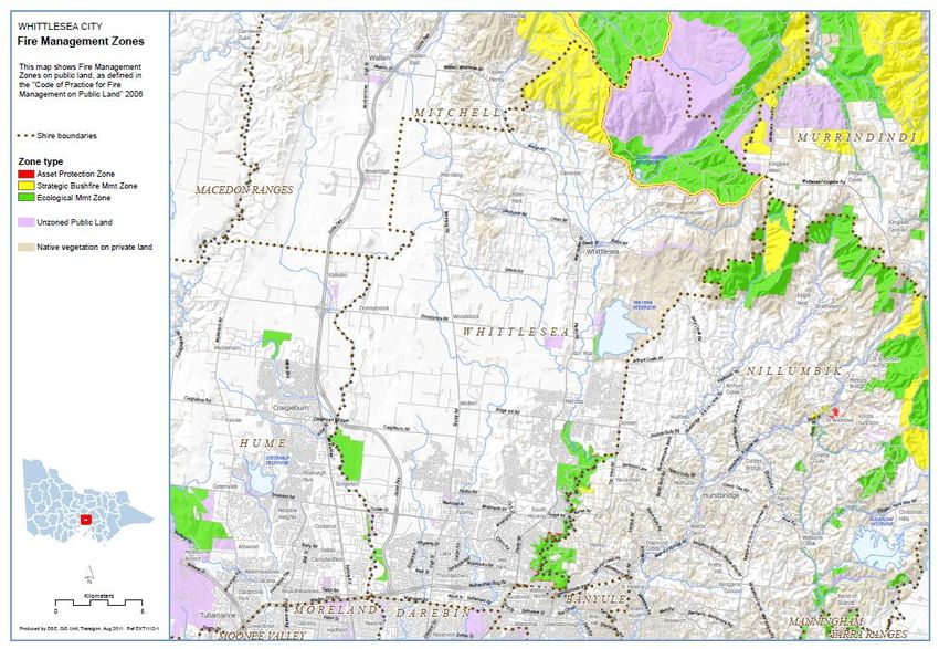
C.2 Townships Protection Plans (TPP) ............................................................................ 22
                  C.3 Neighbourhood Safer Places (NSP) .......................................................................... 22
                  C.4 Community Fire Refuges ........................................................................................... 22
       D          ROADSIDE MANAGEMENT PLAN .................................................................. 23
       E          ENGAGEMENT AND COMMUNICATIONS PLAN ............................................ 24
       F          MAPS ................................................................................................................ 25
       G          RESPONSE PLANS .......................................................................................... 34
       H          RECOVERY PLANS.......................................................................................... 34
       I          PRECINCT (LANDSCAPE) PLANS .................................................................. 34
                  Plenty Gorge Integrated Fire Prevention Strategy ........................................................... 34
       J          TERMINOLOGY USED IN THIS PLAN ............................................................. 35
       K          ACRONYMS USED IN THIS PLAN ................................................................... 36
       L          BIBLIOGRAPHY ............................................................................................... 36

       Attachment 1 - Stakeholder Analysis............................................................................................. 37
       VERSION CONTROL .................................................................................................................... 38

Whittlesea Municipal Fire Management Plan 2020-2023(Version 12)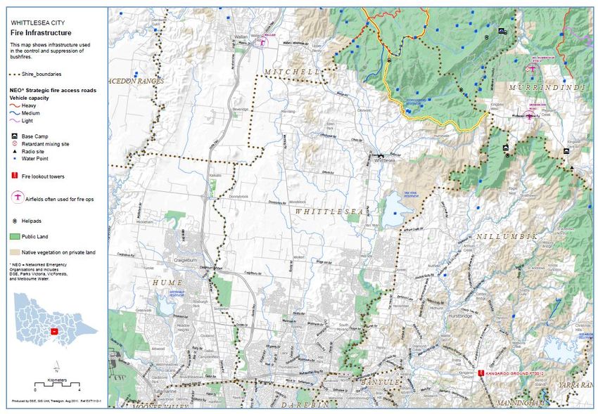
1     INTRODUCTION AND CONTEXT

The Whittlesea City Council Municipal Fire Management Planning Committee was established to:
   • Provide a municipal level forum to build and sustain organisational partnerships
   • Create a common understanding and purpose in fire prevention
   • Ensure that the plans of individual agencies complement the work required

The MFMP is a sub plan of the City of Whittlesea Municipal Emergency Management Plan (MEMP) and has
been produced by and with the authority of the City of Whittlesea pursuant to Section 20 of the Emergency
Management Act 1986; and will be deemed to fulfil Section 55A of the CFA Act 1958.

The primary objective of municipal fire management planning is the protection of life, property and the
environment. It is a coordinated approach by a range of stakeholders to discuss, plan and manage fire
in the community by adhering to a key tenet of emergency planning—Prevention, Preparedness,
Response and Recovery. Stakeholders contribute knowledge, experience, resources and capability and aim
to achieve measurable fire management outcomes through agreed and achievable risk treatments.

The lead focus of the Whittlesea Municipal Fire Management Plan is on the bush and grass fire risk
environment using the Victorian Fire Risk Register as an informing tool. Subsequent iterations will evolve to
more comprehensively address all risk environments within Whittlesea’s fire planning footprint as additional
risk and mapping tools are made available.

What is Integrated Fire Management Planning?

Victoria has a long history of community, government and organisations working together in preventing,
preparing and responding to the threat of fire and recovery from the impact of fire. Recent challenges such
as the decade of dry conditions, population growth in urban-interface areas and the impact of fire events has
prompted the need for increased coordination and cooperation to secure fire safety across Victoria.

In response to these challenges, the Victorian Government established the Integrated Fire Management
Planning Framework (‘IFMP’) for Victoria. It has three levels of planning committees:

 State Level: State Fire Management Strategy provides the guidance for a combined and organised effort
 in lowering the risk of fire through cooperative principles in the State of Victoria.

    Regional Level: Northern and Western Metropolitan Regional Strategic Fire Management Plan provides
    the risk management requirements and quantifies the need for planning at municipal level.

  Municipal Level: The Municipal Fire Management Plan is the only true action plan, of which the combined
  outputs
IFMP  is anofall-agency
              individual agencies and stakeholders
                         planning approach         provides
                                           to managing       a decrease
                                                        the fire          in fire
                                                                 risk across  the threat levels
                                                                                   State of     and ensures
                                                                                            Victoria, with planning
  safer communities through a cooperative effort.

Authority for the plan

The Whittlesea City Municipal Fire Management Plan (MFMP) has been produced by and with the authority
of the City of Whittlesea pursuant to Section 20 of the Emergency Management Act 1986; and will be
deemed to fulfil Section 55A of the CFA Act 1958. The MFMP is a sub plan of the City of Whittlesea
Municipal Emergency Management Plan (MEMP).
Part 6A of the emergency Management Manual Victoria states “in relation to a Municipal Council wholly or
partly in the country area of Victoria, a municipal fire management plan prepared and endorsed in
compliance with these guidelines will be deemed to fulfil section 55AQ of the Country Fire act 1958 which
requires them to have a municipal fire prevention plan with certain defined contents”.

Whittlesea Municipal Fire Management Plan 2020-2023 (Version 12)                                         Page 5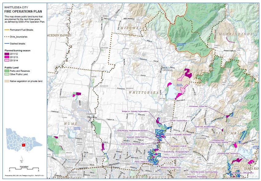
In undertaking section 55A(1) of the Country Fire Act 1958 (the CFA Act) a Council must prepare and
maintain a Municipal Fire Prevention Plan (MFPP) for the relevant municipal district:
    • In accordance with the advice and the recommendation of the Municipal Fire Prevention Committee
        and
    • Containing
            o Identifying particular risks of fire s.55A(2)(a)
            o Specifying how to treat each identified risk s.55A(2)(b)
            o Specifying who is responsible for treating those risks s.55A(2)(c)
            o Identifying all designated Neighbourhood Safer Places s.55A(2)(ca)
            o Designating any places that are community fire refuges s.55A(2)(cb)
            o Any other matter prescribed for inclusion in The Plan s.55A(2)(d)

The Municipal Committee will make recommendations to the Council via the Municipal Fire Management
Plan which the Council will recommend to adopt, modify or reject.

Plan Preparation Process

The MFMP has incorporated where applicable actions from the Regional Fire Plan. The plan does focus
primarily on the risks of grass / bushfire impacts as identified using the Victorian Fire Risk Register. This
covers both public and private land and will be reviewed and updated in line with auditing requirements.

The MFMPC ensures all agencies have ownership and responsibility for the Municipal Fire Management
Plan. All agencies will work together to understand the fire risks within the community and the strategies /s
required to mitigate or remove them at the local level.

Whittlesea Municipal Fire Management Plan 2020-2023 (Version 12)                                       Page 6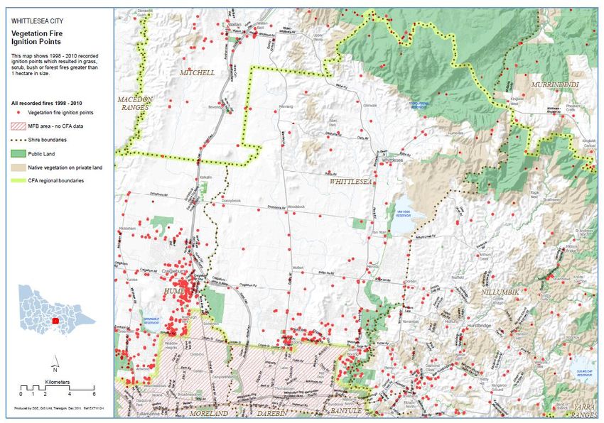
Membership of the Whittlesea Fire Management Planning Committee

The Municipal Fire Management Planning Committee (MFMPC), appointed by the Municipal Emergency
Management Planning Committee (MEMPC), has representation from the following organisations:
    ▪   City of Whittlesea
    ▪   Country Fire Authority
    ▪   Parks Victoria
    ▪   Department of Environment Land Water and Planning ( DELWP ) formally Department of
        Sustainability and Environment
    ▪   Metropolitan Fire Brigade
    ▪   Victoria Police
    ▪   VicRoads
    ▪   Melbourne Water
    ▪   Department of Health and Human Services
    ▪   Other members as required

Role of the Whittlesea Fire Management Planning Committee

The Committee’s purpose, of which the development of a municipal fire management plan is part, is to
provide a municipal-level forum to build and sustain organisational partnerships, generate a common
understanding and shared purpose with regard to fire management and ensure that the plans of individual
agencies are linked and complement each other.

The role of the Committee is to:
    ▪   plan for fire management in a manner that coordinates cooperative fire management activities
        across agencies
    ▪   provide information to and engage with the community on matters related to fire management
        planning
    ▪   use the planning guide issued be the State Fire Management Planning Committee, draft a Municipal
        Fire Management Plan for recommendation to the MEMPC and comment by the North West
        Metropolitan Regional Strategic Fire Management Planning Committee, prior to consideration by the
        Council
    ▪   monitor, review and report on the delivery of the MFMP
    ▪   advocate to the RSFMPC for municipal fire management needs
    ▪   work with the MEMPC to align planning activities
    ▪   share knowledge and create an environment of continuous improvement

Whittlesea Municipal Fire Management Plan 2020-2023 (Version 12)                                Page 7
2    ENGAGEMENT AND COMMUNICATIONS

A requirement of the City of Whittlesea Municipal Fire Management Plan is the development of an
Engagement and Communications Plan to guide how fire management objectives and outcomes are
communicated both to stakeholders and to the broader community.

Community Engagement is guided by the International Association for Public Participation (IAP2) community
engagement model, which is a framework for planning effective communication and engagement on any
issue Inform
       or plan     Consult         Involve           Collaborate     Empower
                                                                                 Place final
                                          Work directly
     Provide balanced   Obtain feedback                        Partner in each   decision making
                                          together to ensure
     information to     on analysis and                        aspect of         in the hands of
                                          issues are
     stakeholders       decisions                              decision making   primary
                                          understood
                                                                                 stakeholders

Using the IAP2 framework model, it’s important that stakeholders understand and appreciate the goals and
objectives of fire management planning. By clearly communicating these objectives, stakeholders will ‘own’
the Plan and make positive contributions both to the Plan and the Committee.

Stakeholders involved in fire management planning in the City of Whittlesea have been listed in this Plan
(see Attachment 2: Stakeholder Analysis) and their level of participation and involvement noted. They have
been identified for their existing knowledge and experience and involvement in fire management planning.

The responsibility for communication and engagement across organisations that are represented on the
municipal committee rests with the organisation itself. Different organisations will develop arrangements for
keeping their staff informed of what is occurring in the implementation of the plan.

3    ENVIRONMENTAL SCAN

City of Whittlesea Profile

The City of Whittlesea is located in Melbourne’s north, about 20 kilometres from the central business district.
The municipality’s southern border is 14.5 kilometres from the Melbourne CBD and the Metropolitan Ring
Road provides direct freeway links to airports, docks and central Melbourne. The municipality is one of the
largest in metropolitan Melbourne, covering an area of approximately 489 square kilometres and about 70
percent of the City is rural in area, with the other 30 percent urban.

Whittlesea is among the fastest growing municipalities in Victoria. The municipality’s population has grown at
a rapid rate during the past 30 years, more than quadrupling from 27,000 in 1969 to approximately 146,000
in 2009 and forecast to reach383,000 people by 2041. Major growth centres are Epping North, Wollert,
Donnybrook Mernda and Doreen.).

Our urban area includes

 Bundoora (split with Darebin and Banyule Councils)            Mill Park

 Doreen (split with Nillumbik Shire)                           South Morang

 Epping                                                        Thomastown

 Epping North                                                  Whittlesea township

 Lalor                                                         Wollert

 Mernda

Whittlesea Municipal Fire Management Plan 2020-2023 (Version 12)                                     Page 8
Our rural areas include

 Beveridge (split with Mitchell Shire)             Kinglake West

 Donnybrook                                        Woodstock

 Eden Park                                         Yan Yean (split with Nillumbik Shire)

 Humevale

Whittlesea Municipal Fire Management Plan 2020-2023 (Version 12)                           Page 9
Multiculturalism

Whittlesea is noted for its diversity, with over half of residents from non-English speaking backgrounds.
These residents bring with them many aspects of their own cultures, which contribute greatly to the character
and identity of the City. In previous decades, a higher proportion of our overseas-born residents were of
European heritage, particularly Italy, Macedonia and Greece.

Between 2011-2016, emerging communities in the City of Whittlesea included residents born in India (+5,866
persons), China (+1,780), Iran (+1,300) and Sri Lanka (+1,211). In 2016, our Aboriginal and Torres Strait
Islander population was 1,635 people, the second largest in Metropolitan Melbourne.

Age Profile

Our community is slightly younger than average, with a median age of 34, compared to 36 throughout
Greater Melbourne. By 2038, our city will have approximately 37,000 more children aged under 17 years
than in 2018 and almost 19,000 more residents aged over 70 years.

Travel and Transport

Key transport infrastructure includes the Plenty Road, Hume Freeway and the Metropolitan Ring Road. The
Hume Freeway effectively creates a boundary between Hume in the west and Whittlesea in the east. A
planning corridor is in place for a new Outer Metropolitan Ring road and a freeway link between the Hume
freeway, Outer Metropolitan Ring Road and the Metropolitan Ring Road. A further connection between the
Eastern freeway and the metropolitan ring road will deliver improved transport options for people living in the
northern growth area.

The City of Whittlesea is served by the Mernda railway line, with stations including Keon Park, Lalor,
Thomastown, Epping, South Morang, Hawkestowe, Middle Gorge and Mernda. Bus routes 381 to 387 serve
the area between South Morang and Whittlesea.

Jobs and Employment

The City of Whittlesea has a large expanding retail/wholesale trade as well as established manufacturing,
warehousing and distribution industries. There are currently seven major growth areas—Janefield, Epping
North, South Morang, Cooper Street, Mernda, Doreen, Laurimar and Whittlesea covering the four main
growth corridors along Plenty Road South and Plenty Road North, Yan Yean Road, Cooper Street and
Epping Road.

The major towns and suburbs are: Thomastown, Lalor, Epping, Bundoora, Mill Park, South Morang, Doreen,
Mernda and Whittlesea. Each suburb/town contains commercial and industrial development with extensive
industrial development primarily within the southern sector of the municipality.

In 2018, there were over 69,000 jobs located in the City of Whittlesea. In 2017, there were around 13,645
local businesses. Approximately 88,500 people who live here are employed. Of our employed residents:
    •   65% work outside of the municipality, many in the areas of Darebin, Hume and inner Melbourne.

    •   62% work full-time and 36% work part-time.
The three highest industry sector employers in the municipality are Health Care and Social Assistance
(13%); Retail Trade (12%); and Construction (10%).

Topography

The municipality has a varied topography from the generally flat urban areas in the south to the rich rural
land and bushland in the north and east of the municipality. The Yan Yean and Toorourrong Reservoirs and
water supply catchments occupy a substantial portion of the north and east parts of the municipality. The
major creeks and streams within the municipality are the Plenty River, Merri and Darebin Creeks.

With 70% of the municipality rural or non-urban, there is a mixture of current uses with stock grazing a
predominant industry. There are also large areas of rural-recreation type subdivisions and extensive areas
of National Park and Melbourne Water/Parks Victoria land.

Whittlesea Municipal Fire Management Plan 2020-2023 (Version 12)                                    Page 10
Fire History
Whittlesea has a history of significant grass fires. High intensity and fast running grass fires can be expected
from January to April influenced by the steep topography to the north. Moderate fuel loads with a mixture of
grass and forest may cause a change in rates of spread. In forested areas, crowning is likely with heavy
spotting. Fires in Whittlesea occur on days of severe or extreme fire danger, with fire travelling from
northwest to southeast usually under a strong north-westerly wind.
Years of significance:
Feb 2009 Black Saturday
Fires on the outskirts of Whittlesea township, in Humevale, Kinglake West. Loss of life,
significant loss of property and economic loss.
A smaller but still significant fire at Plenty Gorge Park on the same day was contained by the
superb efforts of fire crews.
Jan 1982 Mt Disappointment to Whittlesea
Fire on the northern edge of the municipality, spotting in from Mt Disappointment, 100 acres
burnt.
March 1970 Eden Park
Grassfire at Eden Park, 100 acres burn out, two houses damaged, stopped at Grants Road.
Jan/Feb1968 Donnybrook/Woodstock
Multiple fires in three consecutive weeks at Donnybrook Road, Grants Road and Merriang
Road. Merriang Road fire damaged Woodstock hall and church.
Feb 1958 Wollert
Fire on a southerly wind burnt out 200 acres. Tragic loss of firefighter battling the blaze.
1944 Bushfires at Humevale and Kinglake
Jan 1939 Mt Disappointment
Large fire in Mt Disappointment threatened the Plenty Valley, saved by thunderstorm.
Feb 1926 Mt Disappointment to Kinglake
Fire originating in Wandong burnt out most of Mt Disappointment and then jumped into
Bruce’s Creek, Humevale, Strathewen and Kinglake. No lives lost but many houses burnt.
1913/14 Mt Disappointment spotting into Whittlesea
Spotting from Mt Disappointment, fires in Whittlesea and Doreen. 100 acres burnt.
Feb 1851 Mt Disappointment to Bundoora
Mt Disappointment fire jumped into Whittlesea and all the way to Bundoora. Miles of fencing
lost, 20,000 bushels of wheat lost, cattle lost and 100 persons made homeless and
penniless. The McLelland family of Arthurs Creek suffered greatly, with mother and five
children perishing.
March 1846 Plenty River
Fire along Plenty River devastated the Plenty Valley, with losses to agriculture and settlers’
homes and farms.
Whittlesea Municipal Fire Management Plan 2020-2023 (Version 12) Page 11Assumptions for the future The City of Whittlesea is growing at a rapid pace with the population forecast to reach 295,000 people by 2031. Major growth centres are South Morang, Epping North, Mernda, Doreen and Kalkallo–Beveridge (those parts within the City). This growth will impact on the provision of infrastructure and services in these localities. New investments will be required in a number of areas, including public transport, roads, telecommunication services (in particular broadband), health services and more. From a fire service perspective, this growth is being monitored closely and planning is currently being undertaken to ensure residents and businesses in these new areas are receiving adequate fire service coverage now and into the future. Structural Fires The municipality has also experienced significant structural/residential fires in recent history. The City of Whittlesea has a large industrial area both in Epping and Thomastown. The City of Whittlesea is one of the trial municipalities for the V-BERAP (Victorian Built Environment Risk Assessment Process). The V-BERAP process draws knowledge and experience from stakeholders across the emergency management sector. It ensures a consistent and structured approach to emergency risk assessment in the built environment. As a result communities will be better informed about their risk profile and areas in most need will be targeted for treatments. Whittlesea Municipal Fire Management Plan 2020-2023 (Version 12) Page 12
4   MUNICIPAL FIRE MANAGEMENT OBJECTIVES

Plan Objective

The primary objective of the Whittlesea Municipal Fire Management Plan is the protection of human life from
the threat of fire followed by the protection of critical infrastructure; protection of property and economic
assets; and the protection of environmental and cultural values.

To achieve this, the Whittlesea MFMPC will work together in a coordinated manner to discuss, plan and
manage fire in the community across the Prevention, Preparedness, Response and Recovery spectrum.
Stakeholders will contribute knowledge, experience, resources and capability and aim to achieve measurable
fire management outcomes through agreed and achievable risk treatments across an all hazards
environment (bush and grass fire, structure and hazmat).

Alignment to Regional objectives

The Whittlesea Municipal Fire Management Plan is guided by the objectives and actions contained within the
Northern and Western Metropolitan Regional Strategic Fire Management Plan 2015-25

These objectives are categorised according to five themes, with several underlying strategies and actions
driving each objective. These themes are:
    ▪   PLAN TOGETHER: Develop regional, municipal and local fire management planning arrangements
        with a clear purpose and a consistent assessment of risk.
    ▪   COLLABORATIVE IMPLEMENTATION: Develop and implement fire management programs and
        activities in a collaborative manner.
    ▪   BUILDING KNOWLEDGE: Build and share knowledge in the fire management sector and across
        the community.
    ▪   BUILDING CAPABILITIES: Improve the capability of communities, the fire management sector and
        the region to deal with fires.
    ▪   USING FIRE: Using fire to manage fuels and support the health of natural, social and economic
        environments.

All of the actions have broad outcomes and agency accountabilities attached to them and a timeframe for
when they will be achieved.

Strategic Directions
The Whittlesea Municipal Fire Management Plan takes its strategic direction from the Northern and Western
Metropolitan Regional Strategic Fire Management Plan 2015-25 and the State Fire Management Strategy
(2009,) which articulates the vision of fire management in Victoria. Other direction is provided by the Final
Report of the Victorian Bushfires Royal Commission, the Office of the Fire Commissioner, Office of the
Emergency Services Commissioner, CFA and DELWP.

Additional direction is provided with the following plans and programs:
    ▪   City of Whittlesea Municipal Emergency Management Plan
    ▪   Northern and Western Metropolitan Regional Strategic Fire Management Plan 2015
    ▪   CFA Bushfire Response Plans
    ▪   CFA Bushfire Preparedness Program 2
    ▪   DELWP Fire Operations Plan
    ▪   SP Ausnet Bushfire Mitigation Transmission Network Management Plan 2017
    ▪   City of Whittlesea Overhead Electrical Line Clearance Plan.
    ▪   Vic Roads – Roadside Management Strategy
    ▪   Vic Track’s Annual Fire Management Program
    ▪   Neighbouring municipalities’ fire management plans
    ▪   Kinglake Ranges Fire Management Plan

Whittlesea Municipal Fire Management Plan 2020-2023 (Version 12)                                  Page 13
5 RISK MANAGEMENT
Risk Environments
The primary issue identified was the risk of being unable to effectively anticipate, respond and recover from
major fires in a coordinated manner.
A range of specific risks were identified as issues in the metropolitan regions and are listed below.
The risk of failing to:
1. Assess risks across the municipality consistently.
2. Communicate and engage within and across organisations effectively.
3. Engage and communicate with the community appropriately and effectively.
4. Implement integrated fire management planning effectively on private property.
5. Secure appropriate organisational commitment and resources to implement IFMP planning process.
6. Identify all relevant stakeholders.
7. Meet the needs of vulnerable communities to build capacity to access, understand and apply
information to prepare for and respond appropriately to fire events.
8. Failing to adequately consider the impacts of other related legislation.
9. Provide adequate resources to deal with competing priorities.
10. Effectively measure performance.
11. Be able to coordinate systems and process across boundaries.
12. Develop common policies, process and practices that are acceptable to all stakeholders.
13. Access critical data or information to develop integrated plans.
There is also the risk of:
14. Possible loss of biodiversity due to the conflict between conservation and fire management.
15. Possible loss of water quality and waterway protection.
16. Plans not being implemented by agencies and accepted by the community.
In this iteration of the Whittlesea Municipal Fire Management Plan, bush and grassfire risk has been
assessed using the Victorian Fire Risk Register (see Appendices). Structural and hazmat fire risk will be
addressed in future iterations of this Plan with the development of an Urban Risk Profiling Tool V-BERAP.
The Whittlesea Municipal Fire Management Committee has identified five risk environments that are of the
highest priority in the municipal area and therefore requiring risk treatments.
Residential
Primary land use is for the purpose of medium to long term accommodation. Includes residential
Definition housing, units, apartments and caravan parks.
Objective To raise the community’s awareness of fire safety and hazards in and around the residence.
Accommodation
Includes public accommodation, public assembly and special accommodation.
Public accommodation is land used primarily for temporary accommodation (e.g.; hotels,
motels and hostels).
Definition Public assembly is land used for large gatherings of people by multiple groups and organisations
(e.g. sport grounds, churches).
Special accommodation is land used for the accommodation of people who require special
care. (E.g. hospitals, nursing homes).
Objective Encourage all occupants to have a fire safe living environment.
Whittlesea Municipal Fire Management Plan 2020-2023 (Version 12) Page 14Business
Includes both Commercial & Industrial. The land is used for running a business, providing
a service direct to the public or in any part of the production cycle of a product. Includes
shops, shopping centres, offices, cinemas, restaurants, factories and warehouses, and
Definition quarries.
Fires in such premises present a potential risk to life, property and significant economic
loses. Problems include storage of hazardous material and the environmental impact on
surrounding residential and developed areas when an incident occurs.
Objective Reduce the impact of fire and incidents on human life and the environment.
Infrastructure Environment
Includes both infrastructure and transport. Land used to support the supply of essential
Definition services to a community. Includes: pipelines, electricity lines, telephone exchange, public
transport and transportation routes (roads & railway lines).
Objective Identify infrastructure risks and implement appropriate treatments or actions.
Natural (Bush and Grass) Environment
Includes both agricultural & natural. Land used for the production of plant or animal
material. The natural environment includes both private and public land and includes crops
and pasture, native grasslands, bush areas and natural reserves. The risk of bushfire is
Definition
present in all except the most suburban of areas in the municipality. It is a risk that is
difficult to manage, due to the mixture of public land, parks and reserves, privately owned
bush land and small rural residential subdivisions.
Objective Raise community awareness to the risks of living in an urban bush land environment.
Agency risk management
At an agency level, risk treatments already exist through the Victorian Planning Scheme, Building
Regulations and the Building Code of Australia (BCA). In addition, every fire and land agency has had in
place for many years various fire management strategies to treat fire risk:
▪ Hazard Reduction e.g. DELWP/PV planned burn program, multi-agency slashing programs
▪ Ignition Management e.g. (Electric Line Clearance) Regulations 2015
▪ Community Education e.g. CFA Fire Ready Victoria meetings, MFB Community education programs
for diverse groups
▪ Preparedness e.g. Local Incident Management Plans
▪ Property planning e.g. Private property inspections, planning and building legislation.
These agency-specific treatments are noted in this Plan.
Cross boundary arrangements
It is acknowledged that the City of Whittlesea and stakeholder agencies have existing planning relationships
across the following boundaries:
▪ Hume City Council (Western Boundary)
▪ Nillumbik Shire Council (Eastern Boundary)
▪ City of Darebin (Southern Boundary)
▪ City of Banyule (South Eastern Boundary)
▪ Mitchell Shire (Northern Boundary)
▪ Murrindindi (North Eastern Boundary)
Whittlesea Municipal Fire Management Plan 2020-2023 (Version 12) Page 156 PLAN REPORTING AND REVIEW
Plan Endorsement
The Whittlesea Municipal Fire Management Committee is the custodian of the Municipal Fire Management
Plan pursuant to current legislative arrangements.
The MFMPC shall draft a MFMP and seek endorsement, by signature, of the draft plan from the committee
and, where appropriate, non-committee members with responsibilities and accountabilities under the Plan.
Following this process, the MFMPC will recommend the MFMP to the MEMPC for endorsement. Once
endorsed by the MEMPC, the plan will be sent to the Northern and Western Metropolitan RSFMPC for
comment, prior to recommendation to the City of Whittlesea for adoption.
Audit
For councils wholly or partly within the Country Area of Victoria, the MFMP as adopted by Council, will be
deemed to meet the requirement for a municipal fire prevention plan under s. 55A(1) of the Country Fire
Authority Act, provided that it contains the provisions as set out in s. 55(A)2. For other councils, audit
arrangements will be determined prior to the initial audit of the MFMP.
Plan Review
The Plan has a three year lifespan based on current audit requirements contained within Section 55B of the
CFA Act. It is acknowledged that the audit process and planning cycles may change as the IFMP framework
and planning processes evolve.
Ongoing monitoring and annual review is essential to ensure that the Whittlesea Municipal Fire Management
Plan remains relevant and up to date. The Plan will be reviewed and amended:
▪ as further treatment works are completed by the MFMPC
▪ following significant incidents, if required
▪ with changes in local demographics and local risk
▪ as directed by the State or Regional Fire Management Planning Committees
▪ as required by legislation.
Whittlesea Municipal Fire Management Plan 2020-2023 (Version 12) Page 167 APPENDICES Whittlesea Municipal Fire Management Plan 2020-2023 (Version 12) Page 17
APPENDIX A                 RISK MANAGEMENT REGISTER

Risk description

Risk is described as the likelihood of an event occurring multiplied by the consequence of its occurrence.

Likelihood is defined as an event that could occur at least once in every 10 years and Consequence as an
event that could cause significant financial loss, and/or casualties requiring hospitalisation, and/or significant
environmental damage.

Addressing Bushfire Risk

In this iteration of the Whittlesea Municipal Fire Management Plan, bush and grass fire risk has been
assessed using the Victorian Fire Risk Register (VFRR).

The VFRR is a systematic process that utilises the expertise and local knowledge of a range of professionals
and stakeholders in identifying locations and assets at risk from bush or grass fires, then assessing the level
of risk and assigning a range of treatments to manage / mitigate the risk. Stakeholders include
representatives from Council, CFA, MFB, Parks Victoria, Department of Sustainability and Environment,
Victoria Police, Melbourne Water and others.

Under the VFRR process, assets are grouped into several broad categories—Human Settlement, Economic,
Environmental and Cultural Heritage and include residential and commercial properties at risk of bushfire;
key infrastructure such as transmission lines, communication towers and water storage facilities; and any
environmental or cultural assets.

Within each asset category, are the following sub-categories:

 Asset Category                            Asset sub-category
 Human Settlement                          Residential, Special Fire Protection, Other
 Economic                                  Agriculture, Commercial , Infrastructure, Tourist & Recreational, Mines
                                           Commercial Forests, Drinking Water Catchments
 Environmental                             Locally Important, Endangered, Vulnerable
 Cultural Heritage                         Aboriginal Significance, Non Indigenous, Other

Under each category, locations and assets are identified and their level of risk assessed based on a range of
inputs including proximity to flammable vegetation; vegetation type; slope, frequency of fires; and the
probability of a fire igniting on an extreme fire danger day with a fire danger index rating of 100 or more.

The primary output of the VFRR is a Bushfire Risk Register table. This contains the risk assessments for a
specific location/asset with risk descriptors of low, medium, high, very high and extreme. The Register also
assigns a priority risk rating to each asset to assist in prioritising risk treatments. The highest priority risk is
given 1A rating, the lowest a rating of NA (Need for action is unlikely).

Whittlesea Municipal Fire Management Plan 2020-2023 (Version 12)                                           Page 18
VFRR also provides a list of treatment/mitigation actions per each asset location (along with the responsible agency). Treatments may include prevention works such as fuel reduction burning, roadside vegetation management, grass slashing and property inspections or fire preparedness initiatives—such as development of personal bushfire plans, use of CFA’s Home Bushfire Advice Service and provision of fire safety information through the media and the fire agencies during the summer fire season. It is then the role of the Municipal Fire Management Committee to review the VFRR outputs and determine if the risk ratings are appropriate or if new assets need to be identified and placed on the Register. It also considers the VFRR treatment/mitigation works to determine if they are suitable or if additional works need to be undertaken. Complementing this work, VFRR output maps are available to inform and provide a spatial overview of localities with an identified bushfire risk. Both the Risk Register and accompanying Multi-agency Workplan are ‘live’ documents, subject to review by the Municipal Fire Management Planning Committee as new risks are identified and existing risks and treatments updated. The Bushfire Risk Management Register and Multi-agency Workplan are available in the Appendix. Addressing Structural Fire Risk Structural fire risk will be addressed in a subsequent iteration of this Plan with the development of an Urban Risk Profiling Tool V-BERAP. The tool will profile risk within an area, showing levels of risk by environment and generate maps to a small area level, displaying localised geographic concentrations of risk. Risk environments include residential (houses, flats & apartments); residential (group accommodation); commercial (office & retail); industrial (manufacture, wholesale, storage, waste); infrastructure; construction; health care and special accommodation; and education, community and public assembly. Outputs from the tool can be used to inform risk reduction strategies and assist in the development of targeted community education programs. Addressing Hazmat Risk As with Structural fire risk, Hazmat risk will be addressed in a subsequent iteration of this Plan with the development of an Urban Risk Profiling Tool V-BERAP. A.1 BUSHFIRE RISK MANAGEMENT REGISTER The Bushfire Risk Management Register is available in the Appendix. A.2 STRUCTURE FIRE RISK MANAGEMENT REGISTER A Structure Fire Risk Management Register will be included in a future iteration of this Plan once the Urban Risk Profiling Tool V-BERAP is developed and ready for use. A.3 HAZARDOUS MATERIALS RISK MANAGEMENT REGISTER A Hazardous Materials Risk Management Register will be included in a future iteration of this Plan with the development of the Urban Risk Profiling Tool V-BERAP. Whittlesea Municipal Fire Management Plan 2020-2023 (Version 12) Page 19
APPENDIX B                MULTI AGENCY WORK PLAN

B.1     BUSH AND GRASS FIRE MULTI AGENCY WORK PLAN

The Multi-agency Work Plan lists the treatment/fire mitigation works for each location and asset identified to
be at risk. In this iteration of the Whittlesea Fire Management Plan, only the bush and grass fire risk
environments are being considered, with future editions to also include the structural and hazmat risk
environments. Treatments are grouped according to VFRR asset categories (see table on page 16). In the
Work Plan to address bushfire risk, the following columns are being used:

Location/asset: Lists the location of a particular community, commercial property, piece of infrastructure or
other asset/s identified to be at risk of bush or grass fire.
VFRR Map reference: A reference number assigned by VFRR to identify locations in the local government
area.
VFRR Risk Rating: The risk assessment for that location/asset. Descriptors used are low, medium, high,
very high, extreme.
VFRR Priority Risk Rating: A risk number assigned by VFRR to prioritise risk treatments in the local
government area. The highest priority risk is given 1A rating, the lowest a rating of NA.
Treatment/Mitigation Program: Preparedness, Prevention or Response actions to be undertaken by
agencies to manage the risk for a particular location or asset.
Treatment/Mitigation Type: The type of actions identified to manage the risk at a particular location or
asset.
Responsible authority: The responsible authority that is to undertake the action/s.
Date of committee endorsement: The date the Municipal Fire Management Planning Committee has
approved the action/s.
Review Date: A date set when the status of an action is to be reviewed by the Municipal Fire Management
Planning Committee.
Outcome/Further works required: The outcome of that action (and if it has been successful or not),
together with a determination by the Municipal Fire Management Planning Committee if a particular
location/asset requires additional actions not already identified to manage the fire risk at the location/asset.
Notes: Any additional comments related to the outcome of an action.

The Workplan can be found in the Appendix.

B.2     STRUCTURE MULTI AGENCY WORK PLAN

A Structure Fire Multi Agency Work plan will be included in a future iteration of this Plan once the Urban Risk
Profiling Tool V-BERAP is developed and ready for use.

B.3     HAZARDOUS MATERIALS MULTI AGENCY WORK PLAN

A Hazardous Materials Multi Agency Work plan will be included in a future iteration of this Plan with the
development of the Urban Risk Profiling Tool V-BERAP.

Whittlesea Municipal Fire Management Plan 2020-2023 (Version 12)                                      Page 20
APPENDIX C STATUTORY AUDIT OBLIGATIONS
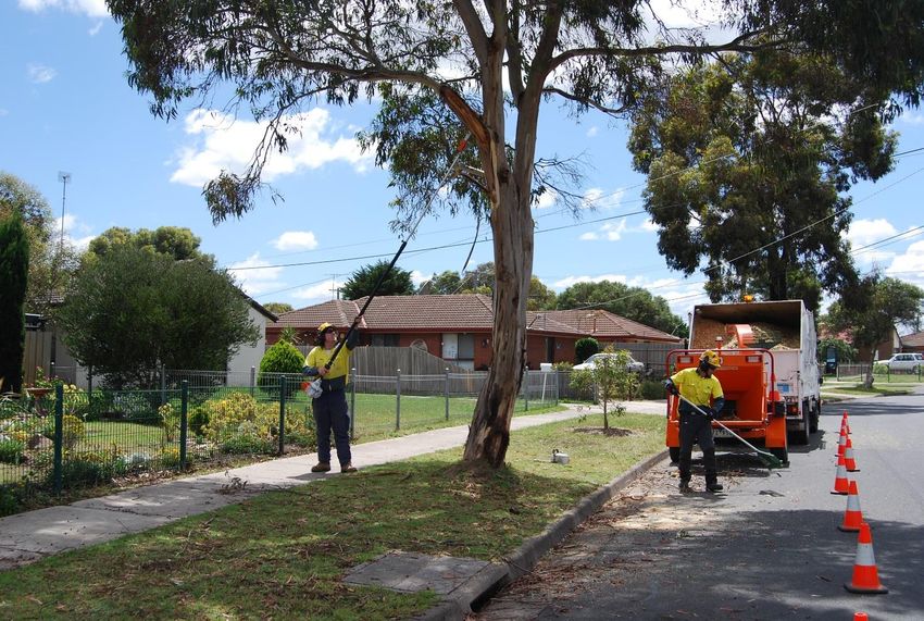
C.1 HAZARDOUS TREES
Hazard trees – identification and notification procedures
The Electricity Safety Act 1998 (Vic) (ES Act) provides that a municipal council must specify, within its
Municipal Fire Management Plan:
(a) procedures and criteria for the identification of trees that are likely to fall onto, or come
into contact with, an electric line (hazard trees); and
(b) procedures for the notification of responsible persons of trees that are hazard trees in
relation to electric lines for which they are responsible.
Under the ES Act, the person responsible for maintaining vegetation and clearance space around power
lines is referred to as the 'responsible person'.
The procedures outlined in this section of the MFMP seek to address the requirement detailed above.
Each responsible person should have its own internal procedure regarding the steps that will be taken when
it receives notification of a potentially hazardous tree.
What is a hazard tree?
According to the ES Act, a hazard tree is a tree which ‘is likely to fall onto, or come into contact with, an
electric line’.
The Electricity Safety (Electric Line Clearance) Regulations 2010 (the Regulations) further provide that a
responsible person may cut or remove such a tree ‘provided that the tree has been assessed by a suitably
qualified arborist; and that assessment confirms the likelihood of contact with an electric line having regard to
foreseeable local conditions.’
Due to legal requirements which require a clearance space be maintained around an electric line, hazard
trees are usually located outside the regulated clearance space. Despite being outside the clearance space,
the tree may still have the potential to contact the line due to its size or because of a structural fault or
weakness which renders part, or all, of the tree likely to contact or fall onto the line.
Who is responsible for a hazard tree?
Under the ES Act, the person responsible for maintaining vegetation and clearance space around power
lines is referred to as the ‘responsible person’. This includes responsibility for keeping the whole or any part
of a tree clear of the line.
Under the ES Act, responsibility is allocated between distribution businesses and other owners of electricity
infrastructure, land owners and occupiers, public land managers such as municipal councils and VicRoads.
Municipal councils are responsible for trees on public land within their municipalities, for which they are the
land manager, where these are also within a Declared Area for the purposes of the ES Act. Primary
responsibility for vegetation clearance and management within the municipality, for areas which are not
within a Declared Area, will usually fall to the relevant electricity distribution company.
Responsible Persons within City of Whittlesea
There are a number of organisations that have responsibility for line clearance in Whittlesea, including:
▪ Jemena
▪ AusNet Services
▪ In the Declared Areas – Whittlesea
Whittlesea Municipal Fire Management Plan 2020-2023 (Version 12) Page 21Other relevant information
Responsible persons, other than private persons, must have an electric line clearance management plan in
place for areas for which they have responsibility (refer Electricity Safety (Electric Line Clearance)
Regulations 2010)
Procedures and criteria for identifying hazard trees
In the course of everyday duties, potentially hazardous trees may come to the attention of staff or volunteer
members of the entities with representation on the Municipal Fire Management Committee (the Committee),
staff of the distribution business(es) or other persons, including members of the public.
There are a range of factors which may indicate that a tree is a hazard tree. That is, a tree which is likely to
fall onto, or come into contact with, an electric line. Some of these factors will be obvious when looking at
the tree but many may only be apparent when the tree is assessed by a person with specific expertise and
training, such as an arborist.
The following criteria may be used to assist in identifying a hazard tree:
▪ The size of the tree suggests that it is likely to come into contact with the electric line, for example
because it appears to be encroaching or growing into the line clearance space.
▪ There is an excessive lean on the tree, or branches hanging off the tree and the tree is in proximity
to an electric (power) line.
▪ The size or appearance of the tree suggests it could come into contact with the line including under
foreseeable local conditions.
If a potentially hazardous tree is identified, the notification procedure outlined below should be followed.
Where a responsible person becomes aware of a potentially hazardous tree for which they have
responsibility, they must follow their own applicable internal procedure and the notification procedure
described below does not apply.
Procedures and criteria for notifying hazard trees
To ensure that information regarding potentially hazardous trees is captured in an efficient manner and, as
appropriate, referred to the responsible person for action, the following procedure for the notification of
hazardous trees should be followed:
▪ The person nominated by the Committee(the primary responsible person) is the person to whom
potentially hazardous trees should be reported.
▪ The primary responsible person (or their representative) is referred to in these Procedures as the
primary responsible person representative (PRPR).
▪ Where any person becomes aware of, or receives a report of, a potentially hazardous tree within the
municipality, this should be referred to the PRPR. Where the Committee becomes aware of, or
receives a report of, a potentially hazardous tree within the municipality, this must be referred to the
PRPR.
▪ Reports of potentially hazardous trees must be provided to the PRPR for action as soon as
practicable. Reports must include, at a minimum:
▪ The name and contact details and any relevant qualifications where known of the person
making the report
▪ As much detail as possible about the location of the tree (including, where known, GPS
coordinates, details of numerical/name plate on nearest pole, name of nearest road or
crossroads, closest landmark, whether tree is on private land or road reserve etc.)
▪ A description of the tree (including, if known, the genus and species of tree)
▪ The primary reasons given for the tree being identified as potentially hazardous (eg. tree is
in proximity to an electric line AND there is evidence of structural weakness and/or
excessive lean and/or appears to be encroaching into line clearance space etc.)
▪ An indication of whether or not urgent action is required.
▪ The PRPR must take all necessary steps to advise the person responsible for the tree that it may be
hazardous.
Whittlesea Municipal Fire Management Plan 2020-2023 (Version 12) Page 22Primary Responsible Person Representative (PRPR)
For the purposes of this part of the Plan, the primary responsible person is the Senior Arborist for City of
Whittlesea.
Contact details for the Parks Coordinator, are as follows:
Agency name City of Whittlesea
Position title of contact person Senior Arborist
Telephone Number 03 9401 0555
Email address info@whittlesea.vic.gov.au
Facsimile Number 03 9409 9842
Procedures for Notification of Responsible Persons
Where a potentially hazardous tree has been reported to the PRPR, the PRPR should follow the procedure
outlined below.
Step 1 Report provided to PRPR.
Step 2 PRPR to determine who the responsible person is in relation to the reported tree.
(If necessary, the PRPR can seek assistance from ESV for this step.)
Step 3 Is the responsible person the Yes => applicable internal procedure for referral and
primary responsible person? assessment of potentially hazardous tree to be followed.
No => proceed to Step 4.
Step 4 Did the report indicate that urgent Yes => the responsible person should be notified as
action is required? soon as possible, and by the close of the next business
day..
No => the PRPR must advise the responsible person of
the existence and location of a potentially hazardous
tree in accordance with the timelines below.*
* The PRPR should put in place mutually agreed arrangements for the manner in which it passes on reports
of potentially hazardous trees to responsible persons. (By E-mail).
Reporting Timelines
The PRPR should provide reports to the relevant responsible person as soon as practicable.
In circumstances where:
▪ the potentially hazardous tree is located within a high bushfire risk area (as per s.80 of the ES Act)
and the potentially hazardous tree is reported during the fire danger period declared under the
Country Fire Authority Act 1958 (Vic); or
▪ the report indicates that there is an imminent danger that the tree will contact or fall onto lines as a
result of minor environmental changes;
the potentially hazardous tree must be referred to the relevant responsible person for action as soon as
possible, and by the close of the next business day.
Each responsible person (other than the primary responsible person) must provide the PRPR with contact
details of the person (position title) to whom reports should be provided. It is the responsibility of each
responsible person to ensure that the PRPR is provided with up-to-date contact details.
Whittlesea Municipal Fire Management Plan 2020-2023 (Version 12) Page 23Register The PRPR will maintain a register in which all notifications are recorded together with the date of receipt of the notification and the date the notification was reported to the responsible person. This will be achieved by the use of Council’s Electronic Document handling system. It is recommended that responsible persons also maintain a register of notifications received of hazardous trees for which they are the responsible person. PRPR Consultation The Committee notes that the Primary Responsible Person was consulted in relation to the development of these procedures. The City of Whittlesea has an Overhead Line Clearance Plan 2013 which is updated yearly and is available on request from the senior arborist. C.2 TOWNSHIP PROTECTION PLANS (TPP) Township Protection Plans provide a planned response for both emergency services and the community to a bush/grass fire within close proximity to a township, which has the potential to impact on the local community. The City of Whittlesea has two Township Protection Plans, one for the Eden Park community and one for Whittlesea township. These Plans sit under the Municipal Emergency Management Plan for the City of Whittlesea. A copy of these plans is also available on the CFA website at www.cfa.vic.gov.au.http://www.cfa.vic.gov.au/ C.3 NEIGHBOURHOOD SAFER PLACES (NSP) Neighborhood Safer Places are locations of last resort and are designed to provide sanctuary for people from the immediate life threatening effects of a bushfire. They are places or buildings designated and signposted by the municipal council, and that meet guidelines issued by the Country Fire Authority. The City of Whittlesea has one designated Neighbourhood Safer Place, Place of Last Resort at AF Walker Reserve, 2 Forest Street Whittlesea (Melway Ref: Map 246,G9.). For more information on NSPs, visit www.cfa.vic.gov.au. C.4 COMMUNITY FIRE REFUGES The City of Whittlesea does not have any identified Fire Refuges Whittlesea Municipal Fire Management Plan 2020-2023 (Version 12) Page 24
You can also read