Caloundra Aerodrome Master Plan - Draft - Caloundra Aerodrome - App A Master Plan - Sunshine Coast Council
←
→
Page content transcription
If your browser does not render page correctly, please read the page content below
Caloundra Aerodrome - App A Master Plan

Caloundra Aerodrome
    Master Plan
        Draft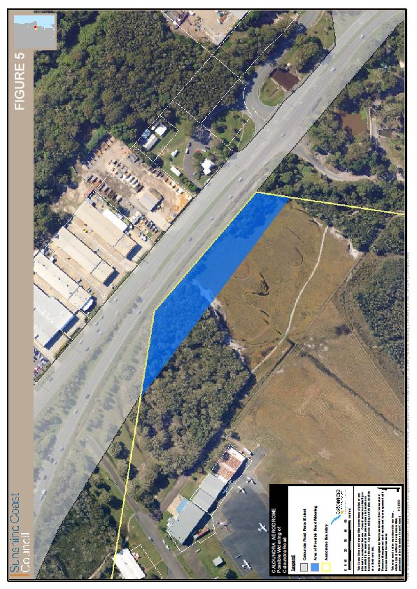
CALOUNDRA AERODROME MASTER PLAN
                                         Caloundra Aerodrome - App    A Master Plan
                                                               PRELIMINARY DRAFT

                                        Table of Contents

EXECUTIVE SUMMARY ............................................................................................ 4
1.          PRELIMINARY MASTER PLAN.................................................................. 9
     1.1.   PURPOSE OF THE MASTER PLAN .......................................................... 10
     1.2.   CONSULTATION ....................................................................................... 10
     1.3.   LEGISLATIVE FRAMEWORK.................................................................... 10
     1.4.   REGIONAL OBJECTIVES.......................................................................... 11
     1.5.   DEVELOPMENT OBJECTIVES ................................................................. 12
2.          CALOUNDRA AERODROME ................................................................... 12
     2.1.   LOCATION ................................................................................................. 12
     2.2.   ROLE AND FUNCTION.............................................................................. 14
     2.3.   USE OF ADJOINING/ADJACENT LAND ................................................... 16
3.          REGIONAL SIGNIFICANCE...................................................................... 18
     3.1.   SOUTH EAST QUEENSLAND CONTEXT ................................................. 18
     3.2.   ECONOMIC SIGNIFICANCE ..................................................................... 19
4.          AVIATION DEMAND FORECASTS .......................................................... 20
     4.1.   CURRENT AIRCRAFT MOVEMENTS ....................................................... 20
     4.2.   FORECAST AIRCRAFT MOVEMENTS ..................................................... 20
     4.3.   IMPLICATIONS FOR THE MASTER PLAN................................................ 22
5.          AVIATION FACILITIES.............................................................................. 23
     5.1.   RUNWAYS 05/03 AND 12/30 ..................................................................... 23
     5.2.   AIRCRAFT MANOEUVRING AREA........................................................... 23
     5.3.   RUNWAY LIGHTING.................................................................................. 24
     5.4.   NAVIGATIONAL AIDS................................................................................ 24
     5.5.   FENCING ................................................................................................... 24
6.          SERVICES AND UTILITIES ...................................................................... 25
     6.1.   STORMWATER ......................................................................................... 25
     6.2.   SEWER ...................................................................................................... 25
     6.3.   WATER SUPPLY ....................................................................................... 26
     6.4.   TELECOMMUNICATIONS ......................................................................... 26
     6.5.   ELECTRICITY ............................................................................................ 26
7.          TRANSPORT AND ACCESS .................................................................... 26
     7.1.   AIRPORT ACCESS.................................................................................... 26
     7.2.   INTERNAL ROAD NETWORK ................................................................... 28
     7.3.   PUBLIC CAR PARKING FACILITIES ......................................................... 28
     7.4.   PUBLIC TRANSPORT ............................................................................... 28
     7.5.   PEDESTRIAN AND CYCLE NETWORK .................................................... 29
     7.6.   PROPOSED CABOOLTURE - MAROOCHYDORE MULTI-MODAL
            TRANSPORT CORRIDOR......................................................................... 29
8.          AIRSPACE................................................................................................. 29
     8.1.   AIRSPACE PROTECTION – OLS .............................................................. 29
9.          ENVIRONMENTAL MANAGEMENT ......................................................... 33
     9.1.   OBJECTIVE ............................................................................................... 33

                                                                                                                         2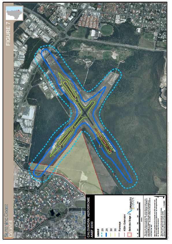
CALOUNDRA AERODROME MASTER PLAN
                                        Caloundra Aerodrome - App    A Master Plan
                                                              PRELIMINARY DRAFT

   9.2.     ENVIRONMENTAL RESPONSIBILITIES................................................... 33
   9.3.     AIRCRAFT NOISE ..................................................................................... 33
   9.3.1.   THE AUSTRALIAN NOISE EXPOSURE FORECAST SYSTEM (ANEF) ... 34
   9.3.2.   NOISE THRESHOLD LEVELS................................................................... 34
   9.3.3.   INTEGRATED NOISE MANAGEMENT MODEL ........................................ 37
   9.3.4.   NOISE MODELLING ASSUMPTIONS ....................................................... 37
   9.4.     FLORA & FAUNA ....................................................................................... 39
   9.5.     GROUNDWATER ...................................................................................... 41
   9.6.     SURFACE WATER .................................................................................... 41
   9.7.     SOIL 43
10.         FUTURE DEVELOPMENT ........................................................................ 44
   10.1.    OPERATIONAL NEED ............................................................................... 44
   10.2.    OPERATOR DEMAND............................................................................... 44
   10.3.    REGIONAL DEMAND ................................................................................ 44
   10.4.    NON-AVIATION DEVELOPMENT ............................................................. 45
   10.5.    EXPANSION OF QUEENSLAND AIR MUSUEUM..................................... 45
   10.6.    MASTER PLAN .......................................................................................... 45
11.         IMPLEMENTATION ................................................................................... 49
   11.1. STAGE 1 (YEARS 1-5) ............................................................................... 50
   11.2. REGULATORY INITIATIVES ..................................................................... 51
   11.2.1. CASR REGISTRATION PROCESS .......................................................... 51
   11.2.2. EXTERNAL LAND USE PLANNING PROTECTION ................................. 51
   11.2.3. INTERNAL PLANNING/APPROVALS PROCESS .................................... 51
   11.2.4. COST ESTIMATES ................................................................................... 52
12.         STAKEHOLDER CONSULTATION .......................................................... 52
APPENDIX A – REFERENCES................................................................................ 54

                                                                                                                   3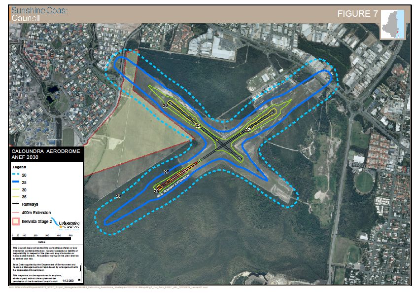
Caloundra Aerodrome - App A Master Plan
EXECUTIVE SUMMARY
Caloundra Aerodrome is owned and operated by the Sunshine Coast Council and
was reserved as an aircraft landing ground in 1931.
The aerodrome site has an area of approximately 145 hectares and accommodates
two sealed runways – runway 05/23 and runway 12/30, both being 795m long and
18m wide.
The aerodrome is bounded to the east north and west by existing urban
development. Recent approvals within the Caloundra South development area will
place additional urban development to the south.
The aerodrome accommodates around 40,000 aircraft movements per annum. Flight
training, particularly training for helicopters, is a significant component of the
Caloundra air traffic.
The Caloundra Aerodrome Master Plan (Master Plan) is a strategic land use planning
document intended to guide future development decisions and achieve Council’s
strategic intent for Caloundra Aerodrome.
This Plan will outline in detail the development of the Aerodrome over the next
20 years to 2032 and will provide a concept for the ultimate development of the site.
The land use planning framework for Caloundra Aerodrome is established by the
Sustainable Planning Act, the South East Queensland Regional Plan and the
Caloundra City Plan.
Regional objectives for the planning of Caloundra Aerodrome are:
Diversification of the region’s economy.
Supporting existing aviation business.
Facilitation and attraction of new appropriate businesses.
Growth of the Sunshine Coast’s tourism industry.
Support for aviation-related community groups and emergency services.
These outcomes are consistent with the themes expressed in Council’s Corporate
Plan.
Development of the aerodrome will seek to achieve the following:
To develop and operate Caloundra Aerodrome in an economically
sustainable manner.
Aerodrome is to be developed as a Registered Aerodrome.
Operations and activities at the aerodrome will be carried out in a manner
which achieves sustainable environmental outcomes.
Amenity of nearby residents will be managed to reduce impacts wherever
practical while not compromising the operational viability of the aerodrome.
Establish where appropriate a balance of aviation and commercial businesses
to deliver enhanced aviation outcomes.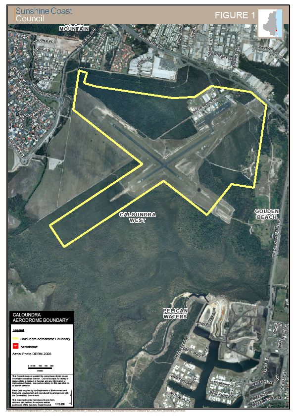
Caloundra Aerodrome - App A Master Plan
CALOUNDRA AERODROME MASTER PLAN                                     PRELIMINARY DRAFT

Caloundra Aerodrome primarily caters for the needs of light aircraft operations in the
Sunshine Coast Region. Operations at Caloundra are confined to helicopters and
light fixed wing aircraft. Regular public transport (RPT) passenger operations are not
contemplated at Caloundra Aerodrome within the forecast Master Plan period.

It is forecast that by 2030 the number of aircraft movements at Caloundra will
increase from 40,000 per annum to 84,000 per annum.

Noise is generally an unavoidable consequence of airport operations. While airports
are responsible for the noise emanating from ground operations, Airservices
Australia is charged with the responsibility of managing the noise impacts of aircraft
in flight. It is this component of airport noise that has the most significance for
affected residents. Ideally land use planning around airports is undertaken to reduce
inappropriate development that would result in conflict between aircraft operations
and noise sensitive land uses.

The ANEF system identifies noise impact by establishing current and predicted
“noise contours”. The ANEF contours are referenced in both Federal Airports
legislation and in the Queensland State Planning Policy 1/02 – Development in the
Vicinity of Certain Airports and Aviation Facilities. Although neither the Federal
legislation or state policy apply to Caloundra Aerodrome it is noted that the current
Caloundra City Plan also relies upon the ANEF contours to identify and establish
land use controls over land deemed to be affected by aircraft noise.

Council has prepared an ANEF diagram based upon the 2030 traffic forecast for the
aerodrome.

                                                                                    5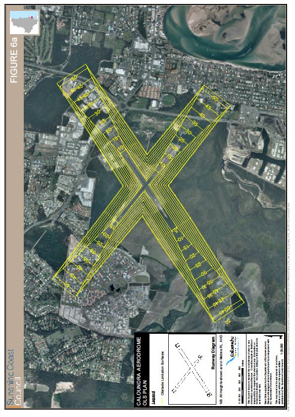
Caloundra Aerodrome - App A Master Plan
CALOUNDRA AERODROME MASTER PLAN                                       PRELIMINARY DRAFT

A more accurate measure of the likely impact of aircraft noise on individual properties
would be provided via the preparation of a Transparent Noise Information Package
(TNIP) for the aerodrome. This package calculates the number of noise events
occurring at a locality that would exceed a specified noise level – typically 70 db
when measured outside a dwelling. This gives an expected noise level of 60 db
inside a typical non-noise attenuated dwelling.

The 60 db sound level is used as it reflects a level, beyond which, normal
conversation is interrupted.

A TNIP model has been prepared for Caloundra Aerodrome. The model indicates
that the impact of aircraft noise will persist significantly beyond the ANEF 20 contour.

                                                                                      6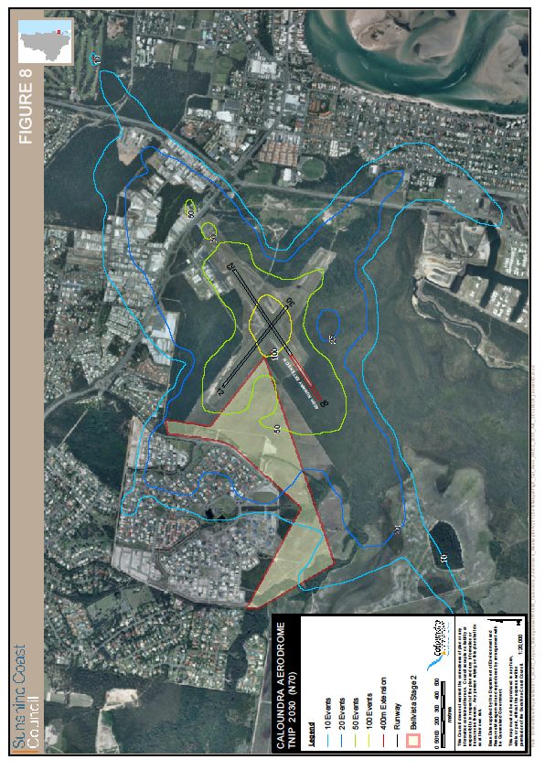
Caloundra Aerodrome - App A Master Plan
CALOUNDRA AERODROME MASTER PLAN PRELIMINARY DRAFT
The Master Plan proposes:
development of additional aviation lease areas;
expansion of aircraft apron are in stages to coincide with the development of
the aviation lease areas;
upgrading the existing grass apron into an all weather surface;
reconfiguration of the existing apron ensuring compliance with CASA
regulations;
reconfiguration of the existing public carpark;
construction of 2 engine run up bays;
construction of a helipad;
identification of a future site for the relocation of the fuel farm;
identification of a future site for public car parking, amenities and viewing
area;
preservation of the land to potentially develop Runway 05/23; (beyond the
horizon of this Master Plan)
identification of a potential non-aviation commercial development area of
approximately 9.5 hectares; and
establishment of a left in/left out access point to Caloundra Road as an
emergency alternative to the present Pathfinder Drive access.
7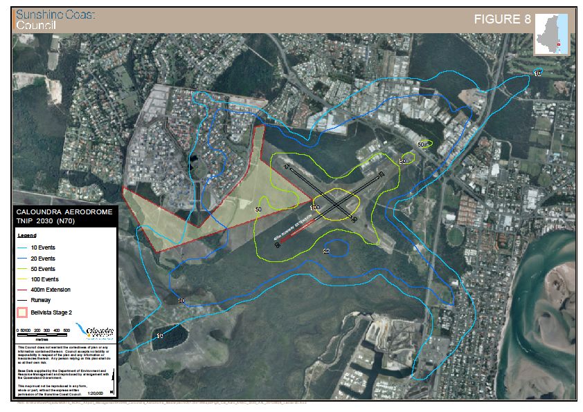
Caloundra Aerodrome - App A Master Plan
CALOUNDRA AERODROME MASTER PLAN PRELIMINARY DRAFT
The implementation of the Master Plan will be staged, with Stage 1 consisting of:
the creation of 1.5 hectares of new aviation business area;
reconfiguration of the existing sealed apron;
conversion of the existing grass apron to an all weather surface for itinerant
aircraft parking; and
establishment of a left in/left out emergency road access point to Caloundra
Road.
Stage 1 will occur over the next 1 to 5 years from the adoption of this Master Plan by
Council.
8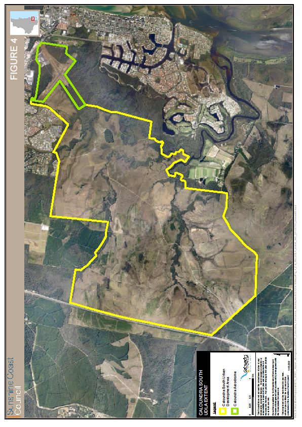
Caloundra Aerodrome - App A Master Plan
CALOUNDRA AERODROME MASTER PLAN                     PRELIMINARY DRAFT

1. PRELIMINARY MASTER PLAN
                     CALOUNDRA AERODROME BOUNDARY

                                                                   9
Caloundra Aerodrome - App A Master Plan
CALOUNDRA AERODROME MASTER PLAN                                        PRELIMINARY DRAFT

   1.1.       PURPOSE OF THE MASTER PLAN

   The Caloundra Aerodrome Master Plan (Master Plan) is a strategic land use
   planning document intended to guide future development decisions and achieve
   Council’s strategic intent for Caloundra Aerodrome. Its purpose is to reserve land
   for future activities based on the forecast growth of the airport business. The
   Master Plan is not intended to detail individual facilities or specific time frames for
   its implementation, rather, it sets the foundation upon which further detailed
   analysis and planning is based.

   Accordingly, the Master Plan will inform Council and assist in decision making
   with respect to economic development and land use planning.

   This Plan will outline in detail the development of the Aerodrome over the next
   20 years to 2032 and will provide a concept for the ultimate development of the
   site. Given the changing aviation environment the plan has been developed to
   allow some degree of flexibility into the future and will be reviewed on a 5 yearly
   cycle.

   1.2.       CONSULTATION

   This Preliminary Draft Master Plan will be developed in consultation with users,
   the community, Government and stakeholders through a series of consultation
   processes. The Draft Master Plan, once approved by Council, will then be
   publicly exhibited and comment sought through a formal consultation process
   prior to the Draft being placed before Council for final adoption.

   1.3.       LEGISLATIVE FRAMEWORK

   Caloundra Aerodrome is governed in accordance with a Deed of Agreement
   executed between the then Caloundra City Council and the Commonwealth
   Government (dated 29 June 1992) whereby Council is required to be solely
   responsible for developing, operating and maintaining the aerodrome in
   compliance with Civil Aviation Regulations and Standards under the
   Commonwealth Civil Aviation Act 1988 and the Air Navigation Act 1920.

   With particular regard to this, Caloundra Aerodrome is currently designated under
   the Civil Aviation Safety Regulations as “Other Aerodromes – operations under
   proposed CASR 135”. In order to reduce risk exposure to Council, it is proposed
   to develop the aerodrome to the necessary standards to have it registered under
   CASR Part 139 and in compliance with Manual of Standards 139 – Aerodromes
   (MOS 139).

   The land upon which Caloundra Aerodrome operates is under Queensland
   Government-controlled tenure (being a Reserve for Landing Ground for Aircraft
   Purposes, with Council as trustee). As a consequence, dealings with interests in
   land are required to be undertaken in accordance with Queensland’s Land Act
   1994. Similarly, given the trusteeship of the reserve is with Council, the
   requirements of Queensland’s Local Government Act 2009 and associated
   Regulations are applied.

                                                                                       10
Caloundra Aerodrome - App A Master Plan
CALOUNDRA AERODROME MASTER PLAN PRELIMINARY DRAFT
Caloundra Aerodrome is not subjected to the requirements of Queensland’s State
Planning Policy 1/02 – Development in the Vicinity of Certain Airports and
Aviation Facilities (SPP1/02). However, in light of recent approvals for major
residential developments adjoining and within close proximity to Caloundra
Aerodrome, and in accordance with Council’s obligations under the above-
mentioned Deed of Agreement with the Commonwealth, it is proposed that a
review of the status of the aerodrome under SPP1/02 be requested of the
Queensland Government to assist in securing the future protection of the
Aerodrome afforded by the policy.
The land use planning framework for Caloundra Aerodrome is established by the
Sustainable Planning Act, the South East Queensland Regional Plan and the
Caloundra City Plan.
Under the Caloundra City Plan, development for aviation related purposes on the
aerodrome is “exempt development” not requiring the approval of a development
application. The development on the aerodrome does however need to have
regard for State and Commonwealth legislation in relation to vegetation
management and biodiversity conservation, dependent upon the nature, location
and impact of the activities being carried out.
There are also a number of State and Local Government legislative and approval
processes, the compliance of which is required for a range of specific
developments.
1.4. REGIONAL OBJECTIVES
In framing this document the overarching regional objectives being sought from
the development of Caloundra Aerodrome are:
Diversification of the region’s economy through growing aviation (in particular,
general aviation) as a cornerstone industry cluster;
Supporting existing aviation business at Caloundra;
Facilitation and attraction of new businesses to the region – particularly given
the increasing pressure upon aviation infrastructure in the South East
Queensland region;
Growth of the Sunshine Coast’s tourism industry through the development of
an iconic tourist attraction at the Air Museum; and
Support for aviation-related community groups and emergency services.
These outcomes are consistent with the themes expressed in Council’s
Corporate Plan.
Sunshine Coast Airports Branch will develop and operate Caloundra in an
economically sustainable manner by managing the business activity on a
commercial basis as directed by Council.
By the application of sound business practices it is forecast that Caloundra
Aerodrome can provide an improved operating result while continuing to support
regional economic diversity and new employment for our community.
11Caloundra Aerodrome - App A Master Plan
CALOUNDRA AERODROME MASTER PLAN PRELIMINARY DRAFT
1.5. DEVELOPMENT OBJECTIVES
In framing this document the objectives being sought from the implementation of
this Master Plan are:
To develop and operate Caloundra Aerodrome in an economically
sustainable manner.
Aerodrome to be developed as a Registered Aerodrome.
Operations and activities at the aerodrome will be carried out in a manner
which achieves sustainable environmental outcomes.
Amenity of nearby residents will be managed to reduce impacts wherever
practical while not compromising the operational viability of the
aerodrome.
Establish where appropriate a balance of aviation and commercial
businesses to deliver enhanced aviation outcomes.
2. CALOUNDRA AERODROME
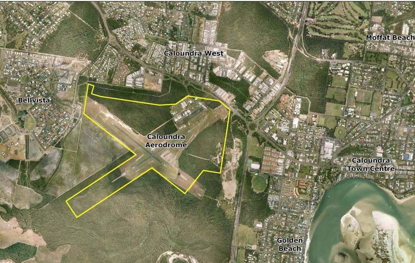
2.1. LOCATION
Caloundra Aerodrome is approximately 65 kilometres north of Brisbane Airport,
22 kilometres south of the Sunshine Coast Airport and 55 kilometres south of
Teewah Airfield.
Caloundra Aerodrome is located approximately 3 kilometres south-west of
Caloundra town centre and is accessed via Caloundra Road.
The site is bounded by Caloundra Road to the north, Pelican Waters Boulevard
to the east, Lamerough Creek bushland to the south and the Bellvista residential
area to the west.
Location Co-ordinates
South: 26’ 48.1’’
East: 153’06.3”
Elevation: 38 feet
Location Identifier:YCDR
Figure 2 shows Caloundra Aerodrome’s location within the context of the broader
South East Queensland region.
12Caloundra Aerodrome - App A Master Plan
CALOUNDRA AERODROME MASTER PLAN PRELIMINARY DRAFT
SEQ REGION AIRPORTS/AERODROMES
13Caloundra Aerodrome - App A Master Plan
CALOUNDRA AERODROME MASTER PLAN PRELIMINARY DRAFT
2.2. ROLE AND FUNCTION
Caloundra Aerodrome primarily caters for the needs of light aircraft operations in
the Sunshine Coast Region. Operations at Caloundra are confined to helicopters
and fixed wing aircraft capable of operating off the existing runway infrastructure.
These aircraft are generally single engine or small twin engine aircraft below
5700kg maximum take off weight (MTOW). This type of operation is known as
General Aviation.
The Bureau of Infrastructure, Transport and Regional Economics within the
Department of Infrastructure, Transport, Regional Development and Local
Government, in its 2008 Statistical Report of General Aviation Activity defines
General Aviation (GA) as “all non-scheduled (non-RPT) flying activities other than
flying activities performed by major Australian airlines”.
General Aviation can be categorised as follows:
Aircraft maintenance – access to maintenance facilities, which in turn require
suitably qualified personnel, is fundamental to General Aviation operations.
Private, business and charter flying.
Sports and recreational flying – particularly in the provision of an accessible
network of facilities throughout the South East Queensland region.
Rotary winged aviation industry – Caloundra Aerodrome businesses currently
provide helicopter training to State organisations from around the world and
maintenance and overhaul services covering Queensland, New South Wales
and a number of international customers.
In addition to flying operations, General Aviation at Caloundra Aerodrome is
supported by a range of ancillary and service industries, such as:
Line service – fuelling and sale of lubricants
Aircraft storage
Aircraft maintenance – major repairs and reconstruction, minor repairs etc
Engine maintenance
Aircraft sales
Parts sales and service
Flying instruction
Regular public transport (RPT) passenger operations are not permitted at
Caloundra Aerodrome under its current CASA categorisation. RPT services are
catered for at Sunshine Coast Airport and this type of operation is not
contemplated at Caloundra Aerodrome within the forecast Master Plan period.
14Caloundra Aerodrome - App A Master Plan
CALOUNDRA AERODROME MASTER PLAN PRELIMINARY DRAFT
SUNSHINE COAST AIRPORT AND AERODROMES
15Caloundra Aerodrome - App A Master Plan
CALOUNDRA AERODROME MASTER PLAN PRELIMINARY DRAFT
2.3. USE OF ADJOINING/ADJACENT LAND
To the north west of the site is the Caloundra West Industrial Estate which
accommodates a range of industrial and commercial activities servicing
Caloundra City.
To the east is Duck Holes Creek Reserve which provides boardwalks across
rehabilitated wetlands. Further east is a recreation reserve which accommodates
sporting facilities and playing fields. This latter reserve adjoins a retirement
village and residential development.
To the west of the site is the Bellvista residential estate, including Bells Reach
(Bellvista Stage 2) residential development which the ULDA has recently
approved.
To the south is the Caloundra South Urban Development Area, under the control
of the ULDA, which includes the development of approximately 20,000 dwellings
over the next 30 years. A proportion of these dwellings will be affected by current
and future operations at Caloundra Aerodrome.
The use of land surrounding the aerodrome is governed by two separate planning
regimes. The Caloundra South Development Area is administered in a land use
planning context by the Urban Land Development Authority Act. Figure 4 below
delineates the land area administered by the UDLA.
The remainder of the urban land surrounding the aerodrome is governed (in the
land use planning context) by Council via the Caloundra City Plan of 2004. A
new Sunshine Coast Planning Scheme is being prepared and will in time replace
the Caloundra City Plan. It is anticipated that the planning intent of the new
Scheme will reflect Council’s decision to maintain Caloundra as an operating
aerodrome.
16Caloundra Aerodrome - App A Master Plan
CALOUNDRA AERODROME MASTER PLAN PRELIMINARY DRAFT
CALOUNDRA SOUTH UDLA EXTENT
17Caloundra Aerodrome - App A Master Plan
CALOUNDRA AERODROME MASTER PLAN PRELIMINARY DRAFT
3. REGIONAL SIGNIFICANCE
3.1. SOUTH EAST QUEENSLAND CONTEXT
Caloundra Aerodrome forms an important component of the South East
Queensland (SEQ) aviation infrastructure. The Brisbane Basin contains a
number of facilities including airports at Gold Coast, Southport, Amberley,
Brisbane, Archerfield, Redcliffe, Caboolture and Sunshine Coast.
Urban development in SEQ remains a significant threat to the long term viability
of some aerodromes placing increasing pressure on the capacity of the
aerodromes to accommodate future growth. Additionally it should be noted that
the growth of passenger traffic at Gold Coast, Brisbane and Sunshine Coast
airports and their capacity to cater for the future demands of the general aviation
industry is limited placing further importance on the existing aviation facilities of
South East Queensland.
Caloundra Aerodrome has been the subject of a number of studies and reviews
by the former Caloundra City Council (CCC) and the State Government. These
studies considered the operational sustainability of the aerodrome within the
context of the Caloundra City Plan and identified the aerodrome as a valuable
general aviation facility. It provides recreational aviation facilities, pilot and
engineering training, aircraft maintenance and aviation services to the Sunshine
Coast.
Operations have however been affected by increasing urban development
adjacent the aerodrome and as a consequence the State Government engaged
consultants GHD to review alternative sites for the relocation of the aerodrome.
The report identified a number of possible sites with the preferred location being
located within the State Forest at Johnstons Road, east of the Bruce Highway,
some 13 km south of the current aerodrome.
At its meeting on 19 August 2010, Council resolved that the existing site would be
retained unless certain conditions in relation to the preferred site were met by the
State. On 2 September 2010, the State announced it would not be meeting the
conditions outlined by Council. Consequently, Council determined that the
existing Caloundra Aerodrome site would remain as an operating aerodrome.
These factors increase the strategic importance of Caloundra Aerodrome and the
necessity of a well planned future.
18Caloundra Aerodrome - App A Master Plan
CALOUNDRA AERODROME MASTER PLAN PRELIMINARY DRAFT
3.2. ECONOMIC SIGNIFICANCE
The Queensland Government’s South East Queensland Regional Plan articulates
as one of its key policy statements that the State will support development of
regional airports as significant economic and social links for regional
communities.
Similarly, Council, through its Corporate Plan themes of “Robust Economy” and
“Effective Business Management” has identified aviation as a driver of the
regional economy. The development and growth of Caloundra Aerodrome will
contribute to the strength and diversity of the economy of the Sunshine Coast
and is consistent with Council’s Corporate Plan aspirations.
A review of the state of the General Aviation sector in South East Queensland
was completed in 2007 (Rehbein AOS) to assess the needs and determine the
likely infrastructure required to meet those needs. The report identified the
following key industry drivers affecting the physical and location requirements for
General Aviation infrastructure in South East Queensland over the next 20 years:
Aircraft maintenance – access to maintenance facilities
International pilot training
Private, business and charter flying
Sports and recreational flying
Helicopter industry – both training and maintenance activities
The report also confirmed that there would appear to be ongoing demand for
commercial General Aviation facilities in the Caloundra catchment area.
Direct Economic Contribution
Caloundra Aerodrome directly employs 129 people, with an additional 50 active
volunteers assisting with operations at the Queensland Air Museum.
Employment opportunities in the General Aviation sector, although smaller in
number than in other industry sectors operating in the Sunshine Coast offer
opportunities for highly trained and comparatively well remunerated employment.
Business activities service in excess of 4,600 customers, with sixty percent of
these customers being based in Queensland, and almost half of these local to the
Sunshine Coast region.
Sixty seven percent of Caloundra Aerodrome operators had an annual turnover
greater than $1million.
The estimated 2009/2010 turnover of the business at Caloundra was in the order
of $43 million. In addition the Queensland Air Museum attracts around
15,000 visitors annually.
19Caloundra Aerodrome - App A Master Plan
CALOUNDRA AERODROME MASTER PLAN PRELIMINARY DRAFT
Broader Regional Economic Contribution
In addition to twenty three percent of operators sourcing in excess of fifty percent
of their supplies from local businesses, Caloundra Aerodrome supports the
diversification of the region’s economy, particularly through the operations of
aviation training schools.
Caloundra Aerodrome operators also create synergies, with agglomeration
benefits through co-location with similar businesses. Examples of this effect
includes attracting tourists and other visitors to the region through the
Queensland Air Museum with a flow-on effect to other tourism-related
opportunities such as skydiving, charter flights and helicopter tours.
4. AVIATION DEMAND FORECASTS
4.1. CURRENT AIRCRAFT MOVEMENTS
Aircraft movement activity has not been monitored and tracked in the past at
Caloundra Aerodrome, hence the base model has been developed from the
application of actual traffic over two periods during August 2010 and March 2011
resulting in a calculated average of approximately 40,000 movements per annum.
The table below shows the movements by aircraft type (GA Fixed wing, GA
Rotary wing and Ultralight) over the monitoring period –
Operation GA Fixed Wing GA Rotary Wing Ultralight Total
Arrivals 187 110 62 359
Departures 211 136 75 422
Circuits 302 297 130 729
Total 700 543 267 1510
Percentage 46% 36% 18% 100%
4.2. FORECAST AIRCRAFT MOVEMENTS
ln the absence of any specific data which related to likely growth of aviation
activity at Caloundra Aerodrome, two broad indicators (industry and population
trends) were used to develop low, medium and high growth scenarios.
The growth rates adopted have resulted in a greater spread of forecasts for the
industry trends than for the population trends. The high industry based forecast
has assumed that there are no constraints to growth associated with factors such
as airspace or runway configuration. All the forecasts developed from industry
and population trends are shown in the graph below –
20Caloundra Aerodrome - App A Master Plan
CALOUNDRA AERODROME MASTER PLAN PRELIMINARY DRAFT
Other influences on traffic forecasts include:
Increasing fuel costs
Increasing use of simulators for flying training
Increased congestion at other GA aerodromes
Introduction of landing and parking fees at Caloundra Aerodrome
Accordingly, the forecast outcome at 2030 is:
Indicators Low Medium High
Industry 49,000 84,000 233,000
Population 51,000 56,000 62,000
This Master Plan has adopted the medium scenario based on industry trends as
its 2030 forecast i.e. 84,000 movements.
This scenario:
Recognises the steady increase in ultralight activity;
Recognises the importance of training as a driver of growth; and
Falls close to the result of the high population growth scenario.
21Caloundra Aerodrome - App A Master Plan
CALOUNDRA AERODROME MASTER PLAN PRELIMINARY DRAFT
The larger provider of flying training services at Caloundra has advised that it
foresees a considerable growth in its activities at Caloundra. While no specific
data about its projected level of activity is available for inclusion in this forecast,
this study assumes that the proportion of rotary wing aircraft movements may
increase from the present estimated 26% to 50% of the total movements. The
total number of circuits due to this increased training activity has been increased
to 80% of the total movements. Consideration of the development of a satellite
training area to reduce the impact of helicopter circuit training activity may be an
opportunity in the future.
Using the current mix of aircraft activity identified by the site monitoring, an
estimate of movement type has been produced for the 2030 forecast. This is
shown in the table below. The arrival and departure movements have been
rounded off to balance.
Break Up of Forecast Movements
Aircraft Type Total Arrival Departures Circuits #
GA Fixed Wing 20,034 3,113 3,113 13,808
GA Rotary Wing 42,050 2,184 2,184 37,682
Ultralights 22,016 2,734 2,734 16,548
Total 84,100 8,410 8,410 67,280
4.3. IMPLICATIONS FOR THE MASTER PLAN
It is appropriate for Council to manage the site in such a way that can satisfy this
demand. In order to accommodate increased activities at Caloundra, additional
leased land will be required to enable existing operators to expand and grow their
businesses as well as cater for additional operators who express interest in
relocating to Caloundra Aerodrome.
To accommodate this expected demand for additional land, an additional 6.8ha of
leasable land has been identified for aviation purposes (1.5ha Stage 1).
The increased helicopter training activity identified within the forecast presents
additional challenges for residents of the recently approved development of Bells
Reach. This residential development lies adjacent the intersection of the two
existing runways and at the confluence of two helicopter training circuits that
were designed to avoid existing residential developments. The development was
strenuously objected to by Council, however approval was subsequently granted
by the Queensland Government in 2011. Residents of this development will be
seriously impacted by current and future aircraft noise.
22Caloundra Aerodrome - App A Master Plan
CALOUNDRA AERODROME MASTER PLAN PRELIMINARY DRAFT
5. AVIATION FACILITIES
5.1. RUNWAYS 05/03 AND 12/30
Runways 05/03 and 12/30 are both 795m in length, 18m wide and sealed. The
width, length and strength of the runways are considered suitable to
accommodate existing and future short to medium term traffic requirements with
regular maintenance.
The Master Plan does not contemplate any changes to the existing Runway
12/30 within the forecast period. It is however prudent to protect the land for this
possibility in the future.
A 404m extension is possible to accommodate payload increases for existing
aircraft operations. It should be noted that the width of the runway will remain the
major constraint in accommodating larger aircraft types than are currently
operating at Caloundra and while this potential extension will be protected for the
future the development is not proposed in the short to medium term.
5.2. AIRCRAFT MANOEUVRING AREA
The main sealed apron is contiguous to the lease areas at the northern end of the
aerodrome and is capable of accommodating up to 30 light aircraft.
The apron is connected to Runway 05/23 by a single taxiway and is also
internally serviced by a network of apron edge taxiways.
The capacity of the apron is insufficient to meet current requirements and
provides a challenge for aircraft maintenance organisations to park aircraft
awaiting maintenance. This situation is exacerbated to some extent by the
location of the fuel bowsers and the long term parking of unserviceable aircraft. It
is anticipated that some aircraft parking relief will be gained by the
implementation of aircraft parking fees whereby seldom used aircraft parked at
Caloundra are likely to relocate to other, free use, facilities.
A secondary natural surface apron is located abeam the northern end of the
sealed apron. This natural surface apron becomes unusable for a significant part
of the year after rain. It is proposed to upgrade this apron and the associated
connecting taxiway to a gravel surface in the short term to increase its usability
and reduce congestion on the main sealed apron.
An extension of the existing sealed apron to the south east has also been
incorporated into the Master Plan as part of the Stage 1 development works
(years 1-5) associated with increases in hangar development sites and the
relocation of the fuel farm is preserved in the Stage 1 area.
These two developments will effectively double the parking capacity of the
aerodrome and allow sufficient parking for the medium (5-10 year) term.
23Caloundra Aerodrome - App A Master Plan
CALOUNDRA AERODROME MASTER PLAN PRELIMINARY DRAFT
Further development in terms of a dedicated aircraft run up bay and helipad are
included in the Stage 1 works to accommodate the operational requirements of
both fixed and rotary winged aircraft maintenance.
A new taxiway connecting the southern end of the extended apron to the runways
will be required to increase operational efficiency of both the runways and apron.
Provision of future access from the Queensland Air Museum to the sealed apron
has been considered to facilitate the transfer of flying exhibits should this be
required.
5.3. RUNWAY LIGHTING
Pilot activated runway lighting is provided on Runway 05/23 for night time
operations. No augmentation of this system is currently proposed.
5.4. NAVIGATIONAL AIDS
Caloundra Aerodrome is not equipped with navigational aids. There are two
illuminated windsocks which are considered adequate to meet short and medium
term needs.
5.5. FENCING
The airside area of the aerodrome is suitably fenced with access controlled by
locked vehicle gates and keypad operated pedestrian gates. The gates and
fencing have been substantially upgraded in the past 2 years, although some
maintenance is required as found in the recent risk assessment process.
The extensive length of the fencing, at approximately 5.3 kilometres, does mean
that the maintenance of the fence requires continual oversight with significant
resourcing implications.
Closed circuit television cameras have also been installed to assist in the
investigation of any security breach. The cameras focus upon the apron and
taxiway to Runway 05/23.
24Caloundra Aerodrome - App A Master Plan
CALOUNDRA AERODROME MASTER PLAN PRELIMINARY DRAFT
6. SERVICES AND UTILITIES
6.1. STORMWATER
The aerodrome site is very flat and low lying. The drainage system consists of a
mixture of piped and open drainage lines.
It is known that while the runways remain above the Q100 level that there are
nuisance flooding events associated with the taxiway and grassed areas adjacent
to the existing aircraft apron become unusable for even light aircraft after
relatively minor rain events.
Council’s recent Lamerough Creek Drainage Investigation confirms that the
runway, apron and existing lease areas will remain free of flooding up to the
Q100 event.
A review of the adequacy of the piped and open drainage lines will be carried out
as part of the design of the new lease areas (Stage 1 expansion). Similarly the
design phase of the proposal to develop the grass apron to ‘all weather’ status
will include the review of the current ‘overland flow’ and drainage swales in that
part of the site.
6.2. SEWER
The sewerage infrastructure at Caloundra Aerodrome consists of connections
from each lease area to a reticulated pipe system that incorporates a sewage
pump. The system from the individual lease area connections is maintained by
Unity Water. A number of the individual lease areas operate holding tanks with
pumps to lift effluent to the Unity Water sewer due to the very flat nature of the
site and the fact that a number of the connections have ‘evolved’ from previous
on site disposal systems.
Unity Water advises that the present system is adequate to meet the needs of
existing development on the aerodrome. Any substantial expansion of
development will require augmentation of the sewerage system. The provision of
a new sewage pump will likely be required as part of the Stage 1 expansion due
to the difficulty in achieving adequate fall from this area to the existing sewage
main in Pathfinder Drive.
The augmentation cost would be a cost to the new development area. It would
not be regarded as ‘headworks’ provided by Unity Water.
25Caloundra Aerodrome - App A Master Plan
CALOUNDRA AERODROME MASTER PLAN PRELIMINARY DRAFT
6.3. WATER SUPPLY
A reticulated water supply is provided via 150mm pipe from the Caloundra
Road/Pathfinder Drive intersection. The pipe reduces in size to 100mm part way
along Pathfinder Drive. Discussions with Unity Water confirm that the existing
water supply is appropriate to meet demands from both the existing and
proposed (Stage 1 expansion) development at Caloundra. Accordingly, other
than the extension of the water service necessitated by the proposed Stage 1
expansion, no augmentation of the water supply infrastructure is proposed.
6.4. TELECOMMUNICATIONS
The aerodrome site is serviced by the Telstra fixed line network and by a range of
mobile telecommunications service providers consistent with the urban areas
across the Sunshine Coast. It is considered that the current telecommunication
infrastructure is appropriate for the ongoing operation and proposed expansion of
the aerodrome.
6.5. ELECTRICITY
A reticulated urban standard electricity supply is provided to the aerodrome.
Individual lease areas are separately connected and metered. Discussions with
the supplier Energex indicate that the current network is appropriate to meet the
needs of the existing and proposed (Stage 1 expansion) development. It was
noted that in the case of some of the individual lease areas, upgrading is required
to the private infrastructure to reflect growth in power usage and to ensure
reliability.
Further discussions with Energex will be required when Energex commence the
planning to service the Caloundra South Development Area to ensure any
overhead infrastructure does not impact upon the safe operation of the
aerodrome.
7. TRANSPORT AND ACCESS
7.1. AIRPORT ACCESS
The Department of Transport and Main Roads (DTMR) has commenced a
corridor study for Caloundra Road. As indicated on Figure 5 below. it is possible
that widening of Caloundra Road will be required to accommodate future traffic
growth and based on preliminary discussions with the DTMR a road widening
strip of 30 metres has been included in the Master Plan to accommodate this
development.
The potential widening of Caloundra Road and the upgrading of Caloundra
Road/Nicklin Way intersection may have implications within the context of the
Obstacle Limitation Surfaces as the road is reasonably close to the Runway
05/23 northern end. The DTMR has been advised of this potential issue.
26Caloundra Aerodrome - App A Master Plan
CALOUNDRA AERODROME MASTER PLAN PRELIMINARY DRAFT
CALOUNDRA AERODROME POSSIBLE WIDENING OF CALOUNDRA ROAD
27Caloundra Aerodrome - App A Master Plan
CALOUNDRA AERODROME MASTER PLAN PRELIMINARY DRAFT
7.2. INTERNAL ROAD NETWORK
The aerodrome is serviced by two internal roads, Pathfinder Drive and Henebery
Place.
Both roads will need to be extended to accommodate the future hangar and
commercial developments, however the existing widths are considered adequate
for the master planning period.
The DTMR has been requested to consider the provision of an alternate
emergency access direct from Caloundra Road to Henebery Place. A left in/left
out access is proposed to allow continued access in the event the principal
Pathfinder Drive access is blocked for any reason.
7.3. PUBLIC CAR PARKING FACILITIES
The sealed public carpark accommodates approximately 30 vehicles. The
carpark is anticipated to be retained in the short term while Stage 1 works are
completed. The carpark is predominantly used by the general public to watch
aircraft operating (plane spotting) and to service the customers of nearby leases
including the Queensland Air Museum (QAM). While the carpark is generally
under-utilised with the future development of the QAM, parking is likely to
become a significant issue for the museum and the carpark is unlikely to fully
meet its future needs. Property held by the State Government to the north west
of the existing museum site with road frontage has been identified as a potential
area for expansion of both exhibit sites and future carparking for the museum.
A site north of the runway intersection in Stage 1 has been identified as a
community area for plane spotting and the development of public facilities to
encourage participation in the aviation industry. The concept includes
carparking, a public viewing area, a BBQ area and toilets.
The current carpark and toilet block area could be redeveloped to provide visitor
amenities and some parking as part of the proposal referred to in section 5.2 to
provide a link between the museum and the apron.
A carparking management plan will be developed for the site to assist in
managing carparking particularly the demands associated with ‘special’ events at
the Air Museum.
7.4. PUBLIC TRANSPORT
Public transport services to the aerodrome are provided via bus services along
Caloundra Road. There is no aerodrome specific service. The Sunbus 603 and
605 routes pass the site and connect to a range of destinations including:
Caloundra CBD
Kawana Town Centre
Landsborough Railway Station
28Caloundra Aerodrome - App A Master Plan
CALOUNDRA AERODROME MASTER PLAN PRELIMINARY DRAFT
The nearest bus stop to the aerodrome is located at Caloundra Road and
Latcham Drive, 415m from the Aerodrome.
7.5. PEDESTRIAN AND CYCLE NETWORK
The aerodrome is connected to a Council designated cycle/pedestrian route that
runs parallel to Caloundra Road through the aviation reserve. The
pedestrian/cycle path connects the aerodrome to surrounding residential and
business areas.
Future development on the aerodrome will respond to this infrastructure by
including facilities for cyclists to be accommodated within the existing road
reserves.
7.6. PROPOSED CABOOLTURE - MAROOCHYDORE
MULTI-MODAL TRANSPORT CORRIDOR
Dialogue between Council and Queensland Department of Transport and Main
Roads has indicated that there will be a need in the future to facilitate access
from Caloundra Aerodrome to the proposed Caboolture-Maroochydore Multi-
modal transport corridor. The Master Plan concept demonstrates that connection
to the CAMCOS corridor could be achieved through the extension of Henebery
Place in a south-easterly direction in conjunction with the future development of
that part of the aerodrome. The possible need for the CAMCOS corridor to
encroach upon the aerodrome site would be considered providing the corridor
and its operation did not impinge upon the then current or future operations of the
aerodrome.
8. AIRSPACE
8.1. AIRSPACE PROTECTION – OLS
The Obstacle Limitation Surfaces (OLS) diagram is the means by which the
critical operational airspace of the aerodrome is defined and protected. The OLS
diagram indicates the height above which temporary or permanent obstacles
such as buildings, chimneys, cranes, phone towers and the like would impede the
safe approach and/or departure of aircraft from the aerodrome.
An OLS diagram has been prepared for Caloundra Aerodrome. The OLS reflects
and protects the potential extension of Runway 05/23 from its present 795m
length to a possible 1199 metre length.
As the OLS is primarily about managing building and development activities in
close proximity to the airport, the OLS diagram will be included in Council’s
planning scheme. The Urban Land Development Authority will be requested to
include the OLS in the Caloundra South Development Scheme.
While cognisant of the approvals already in place, the most effective measure to
reduce both current and future risk exposure to the existing OLS is to seek State
Government endorsement to have this facility nominated as being of State
29Caloundra Aerodrome - App A Master Plan
CALOUNDRA AERODROME MASTER PLAN PRELIMINARY DRAFT
significance and subjected to the requirements of the State Planning Policy 1/02
– Development in the Vicinity of Certain Airports and Aviation Facilities.
30Caloundra Aerodrome - App A Master Plan
CALOUNDRA AERODROME MASTER PLAN PRELIMINARY DRAFT
CALOUNDRA AERODROME OLS PLAN
31Caloundra Aerodrome - App A Master Plan
CALOUNDRA AERODROME MASTER PLAN PRELIMINARY DRAFT
CALOUNDRA AERODROME OLS PLAN
32Caloundra Aerodrome - App A Master Plan
CALOUNDRA AERODROME MASTER PLAN PRELIMINARY DRAFT
9. ENVIRONMENTAL MANAGEMENT
9.1. OBJECTIVE
Council’s overarching environmental objective is to manage Caloundra
Aerodrome in an environmentally sustainable manner, cognisant of the prime
objective to manage the site to meet the needs of aerodrome operators.
It is intended to develop an Aerodrome Environment Strategy (AES) to address
the ongoing environmental management at the airport.
It will provide the framework for responsible environmental management by
airport users and Council as the manager of the aerodrome.
9.2. ENVIRONMENTAL RESPONSIBILITIES
The range of matters to be addressed in the AES include:
developing and maintaining Caloundra Aerodrome’s environmental
management system;
initiating and following up on environmental reviews of relevant aspects of the
airport;
providing internal resources to work with tenants to protect the environment of
the aerodrome and assist with the investigation of incidents on the site; and
liaising with and, where required, reporting to relevant internal and external
environmental authorities.
It is noted that responsibility for implementing environmental management
measures is established through relevant legislation. Depending on individual
circumstances, it may rest with individual tenants, or Council operational
personnel.
9.3. AIRCRAFT NOISE
Noise is generally an unavoidable consequence of airport operations. While
airports are responsible for the noise emanating from ground operations, Air
Services Australia is charged with the responsibility of managing the noise
impacts of aircraft in flight. It is this component of airport noise that has the most
significance for affected residents. Ideally land use planning around airports is
undertaken to reduce inappropriate development that would result in conflict
between aircraft operations and noise sensitive land uses.
33Caloundra Aerodrome - App A Master Plan
CALOUNDRA AERODROME MASTER PLAN PRELIMINARY DRAFT
9.3.1. THE AUSTRALIAN NOISE EXPOSURE FORECAST
SYSTEM (ANEF)
The Australian Noise Exposure Forecast system (ANEF) is the aircraft noise
exposure index currently adopted in Australia. The ANEF system provides a
measure of noise exposure from aircraft operations around airports. It provides
guidance for land use planning in the vicinity of an airport, taking into account the
following factors of aircraft noise:
the intensity, duration, tonal content and spectrum of audible frequencies of the
noise of aircraft take-offs and landings;
the forecast frequency of aircraft types and movements on the various flight
paths; and
the average daily distribution of aircraft take-off and landing movements in both
day time and night time hours.
9.3.2. NOISE THRESHOLD LEVELS
The ANEF system identifies noise impact by establishing current and predicted
“noise contours”. The ANEF contours are referenced in both Federal Airports
legislation and in the Queensland State Planning Policy 1/02 – Development in
the Vicinity of Certain Airports and Aviation Facilities. Although neither the
Federal legislation or State policy apply to Caloundra Aerodrome, it is noted that
the current Caloundra City Plan also relies upon the ANEF contours to identify
and establish land use controls over land deemed to be affected by aircraft noise.
Land Use Compatibility recommendations are provided by the Standards
Association of Australia in AS2021-2000, Acoustics, Aircraft Noise Intrusion –
Building Siting and Construction. A summary of these recommendations is
provided in the table below.
ANEF Zone of Site
Building Type Acceptable Conditionally Acceptable Unacceptable
House, Home Unit, Flat, Caravan Park Less than 20 ANEF (Note 1) 20 to 25 ANEF (Note 2) Greater than 25 ANEF
Hotel, Motel, Hostel Less than 25 ANEF 25-30 ANEF Greater than 30 ANEF
(Note 1) (Note 2)
School, University Less than 20 ANEF 20 to 25 ANEF Greater than 25 ANEF
Hospital, Nursing Home Less than 20 ANEF (Note 1) 20-35 ANEF Greater than 25 ANEF
Public Building Less than 20 ANEF (Note 1) 20-30 ANEF Greater than 30 ANEF
Commercial Building Less than 25 ANEF 25-35 ANEF Greater than 35 ANEF
Light Industrial Less than 30 ANEF 30-40 ANEF Greater than 40 ANEF
Other Industrial Acceptable in all ANEF Zones
Notes:
1. The actual location of the 20 ANEF contour is difficult to define
accurately, mainly because of variation in aircraft flight paths.
34Caloundra Aerodrome - App A Master Plan
CALOUNDRA AERODROME MASTER PLAN PRELIMINARY DRAFT
Because of this, the procedure of Clause 2.3.2 in AS2021 – 2000 may
be followed for building sites outside but near to the 20 ANEF contour.
2. Within 20 ANEF to 25 ANEF, some people may find that the land is
not compatible with residential or educational uses. Land use
authorities may consider that the incorporation of noise control
features in the construction of residences or schools is appropriate
(see also Figure A1 of Appendix A in AS2021 – 2000).
3. There will be cases where a building of a particular type will contain
spaces used for activities which would generally be found in a different
type of building (e.g. an office in an industrial building). In these cases
Table 7.1 should be used to determine site acceptability, but internal
design noise levels within the specific spaces should be determined
by Table 3.3 in AS2021 – 2000.
4. This Standard does not recommend development in unacceptable
areas. However, where the relevant planning authority determines
that any development may be necessary within existing built-up areas
designated as unacceptable, it is recommended that such
development should achieve the required ANR determined according
to Clause 3.2 in AS2021 – 2000. For residences, schools etc., the
effect of aircraft noise on outdoor areas associated with the building
should be considered.
5. In no case should new development take place in green field sites
deemed unacceptable because such development may impact airport
operations.
Council has prepared an ANEF diagram based upon the 2030 traffic forecast for
the aerodrome.
35Caloundra Aerodrome - App A Master Plan
CALOUNDRA AERODROME MASTER PLAN PRELIMINARY DRAFT
CALOUNDRA AERODROME ANEF 2030
36Caloundra Aerodrome - App A Master Plan
CALOUNDRA AERODROME MASTER PLAN PRELIMINARY DRAFT
9.3.3. INTEGRATED NOISE MANAGEMENT MODEL
While the ANEF system remains the noise impact measuring system referred to
in State and Federal legislation, it is necessary to note that the ANEF is a tool
designed to measure noise impacts of very noisy jet aircraft operation out of
major airports. It is not a tool that can be relied upon to reflect the noise
impacts of light aircraft or helicopters at regional aerodromes. This is
recognised by the Federal Department of Infrastructure and Transport in their
publications entitled:
Expanding Ways to Describe and Assess Aircraft Noise - March 2000; and
Going Beyond Noise Contours – Local Approaches to Land Use Planning
Around Smaller Australian Airports – October 2003
A more accurate measure of the likely impact of aircraft noise on individual
properties is provided via the preparation of an integrated noise management
model calculated using a Transparent Noise Information Package (TNIP) for the
aerodrome. This package developed by the Commonwealth Government
calculates the number of noise events occurring at a locality that would exceed
a specified noise level – typically 70 db when measured outside a dwelling.
This gives an expected noise level of 60 db inside a typical non-noise
attenuated dwelling.
The 60 db sound level is used as it reflects a level, beyond which normal
conversation is interrupted.
A TNIP model has been prepared for Caloundra Aerodrome. The model takes
into account the potential lengthening of the 05/23 runway and indicates that
the impact of aircraft noise will persist significantly beyond the ANEF 20
contour.
9.3.4. NOISE MODELLING ASSUMPTIONS
The assumptions used in the development of the ANEF and TNIP diagrams for
Caloundra Aerodrome are:
05/23 runway extended to 1199m (400m extension to 05 end)
design aircraft – code 2B not exceeding 5700kg MTOW
84,000 aircraft movements per year
limited turbo prop operations – maintenance/ferry/testing/charter only
no regular public transport operations
helicopter operations are 50% of all movements by 2030
330 flying days per year
254 movements per day
80% of movements are circuits
37You can also read