Appendix 3: City and Town Centre Health Checks - Stoke-on ...
←
→
Page content transcription
If your browser does not render page correctly, please read the page content below
Appendix 3: City and Town Centre Health Checks

                                4

Stoke Retail & Leisure Study
A081961                                          10/02/2014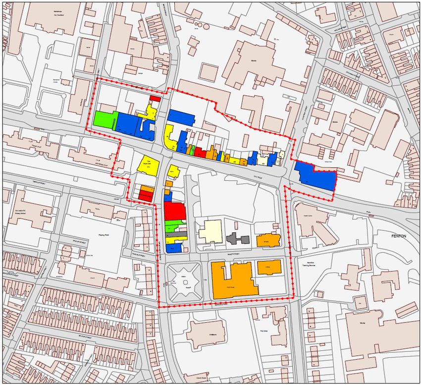
CITY OF STOKE-ON-TRENT - HEALTH CHECK ASSESSMENTS
Introduction
Set out in this Appendix is WYG’s assessment of the vitality and viability of the key centres in the City of Stoke-on-Trent, namely Stoke City centre, Burslem, Fenton,
Longton, Meir, Stoke Town and Tunstall town centres. A comprehensive and detailed evidence base is outlined in the following sections for these centres, with original
survey work undertaken at the centres in order to determine the diversity of use and overall provision of services in these locations. WYG has also drawn on the findings
from the previous North Staffordshire Retail and Leisure Study (2005 – 2021) of August 2005 and, where possible, have made comparisons with the previous data to
identify any historic changes in the centres.

The Importance of Town Centres
The National Planning Policy Framework (NPPF, March 2012) emphasises the need for local authorities to monitor the health of their town centres and determine how
they are changing over time. Indeed, vital and viable town centres help to foster civic pride, promote local identity and contribute towards the aims of sustainable
development. The NPPF states that local authorities should set out policies for the management and growth of centres over the plan period. The Framework requires local
authorities to recognise town centres as the heart of their communities and to pursue policies to support their vitality and viability. It is recognised that competitive town
centre environments should be promoted in order to ensure customer choice, a diverse retail offer and to reflect the individuality of town centres.

Town centres have an important role to play in serving the needs of the local community. They form a focal point for the area and provide a wide range of services that
are accessible to the population, including retail, employment, leisure and education facilities.

Since the turn of the century, town centres nationally have witnessed high levels of vitality and viability with strong retail sales growth and the implementation of major
town centre redevelopment schemes. Therefore, despite the growth of out-of-centre retail development, development activity has been focused within established
centres primarily linked to the ambitious expansion plans of national department stores and key retailers such as Debenhams, Primark and Next. However, the recent
recession has had an impact on consumer spending which in turn has had a negative impact on the vitality of the high street nationally. This has led to an increase in
vacancy rates within many town centres, as retailers attempt to compete in a challenging market and landowners struggle to let their stores to operators.

                                                                                                                                                                                 1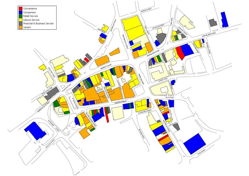
Purpose of the Health Check
It is important that these centres therefore remain competitive in light of increased competition and continue to attract shoppers, visitors and businesses. To achieve this,
they must continually strive to build on their strengths, alleviate their weaknesses and improve the facilities they provide to the community.

Town Centre Health Check Indicators
The NPPF recognises the importance of local authorities preparing an up-to-date and sound evidence base to plan positively for town centre uses. In particular, it is noted
that this evidence base should be used to assess the role and function of town centres and the relationship between them, including any trends in the performance of the
centres. Although the Framework does not provide a list of indicators which should be used to assess the health of a centre, the former Planning Policy Statement (PPS) 4:
Planning For Sustainable Economic Growth (December 2009) had set out a number of key indicators which should be monitored on a regular basis in order to judge the
health of a centre and its performance over time. The performance indicators outlined in PPS4 comprised the following:

Diversity of Main Town Centre Uses
The indicator makes reference to the need to review the diversity of main town centre uses (by number, type and amount of floorspace). This will include reviewing the
different function of each unit to determine whether it represents a convenience, comparison, retail service, leisure service or financial and business service use. This
information is obtained from Experian Goad, though it should be noted that smaller centres are less likely to have been surveyed by Experian. The analysis by WYG compares
the proportion of different uses in each centre against the UK national average rates.

The Amount of Retail, Leisure and Office Floorspace in Edge-of-Centre and Out-of-Centre Locations
In addition to reviewing the diversity of retail, leisure and office uses in a town centre, there is also a requirement to review the quantum of floorspace which exists in edge-
of-centre and out-of-centre locations. The NPPF defines that retail units at edge-of-centre locations are defined as being well connected and up to 300 metres from the
Primary Shopping Area of the town centre, and that for all other main town centre uses, it should be within 300 metres of a town centre boundary.

Potential Capacity for Growth or Change
This indicator involves a review of the opportunities available for the centre to expand or consolidate, with this information typically measured in the amount of land available
for new or more intensive forms of town centre development. The indicator also requires the review of any extant or emerging planning permissions for new town centre
uses, both within and out of the centre. In addition, land which has been allocated within the development plan for town centre uses and which may have not come forward
and/or which may be vacant will also be identified to assess any potential new development sites for town centre uses.

                                                                                                                                                                                    2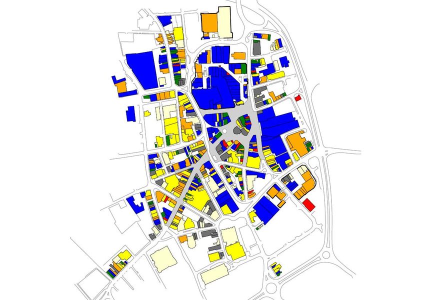
Retailer Representation and Retailer Demand
This indicator should be used to determine the existing retailer representation in a given centre and intentions to change representation within centres, including the
demand of retailers wanting to come into a centre. The Estates Gazette database (EGI) is used to identify commercial demand and retailer requirements for floorspace in
town centres, whilst also recognising that this source only represents a limited number of operators. WYG note that such requirement searches will also not identify
independent retailers considering premises in the area. In addition, it should be noted that retailer demand can also be strongly influenced by the provision of new
schemes being made available and effectively marketed. The analysis can also include a review of the number of national or independent retailers which are present
within a centre, recognising that multiple retailers (such as Boots, Marks & Spencer and Debenhams) can act as anchor tenants in the centre, thus adding to its appeal
and attracting a greater number of shoppers. Venuescore’s UK Shopping Venue Rankings (2013) is used to identify the retail hierarchy of the centres, using a weighted
scoring system which takes account of the presence in each location of multiple retailers.

Shopping Rents
An analysis of the rate of Zone A shopping rental patterns in the primary shopping area of a town centre can provide an important indication of the overall strength and
competitiveness of the centre. It is also important to review the movement of rental patterns over a few years and compare the figures with other nearby centres. Zone A
rents is defined as the value for the first six metres of floorspace in retail units from the shop window. The data can be obtained from Estates Gazette, which uses Colliers
CRE’s data in respect of open market Zone A rents.

Vacant Street-Level Property
The number of vacant units within a centre can provide a good indication of how a shopping centre is performing. However, care should be taken when interpreting
figures. Vacancies can occur for positive as well as negative reasons; for example, the opening of a new retail centre elsewhere in a town may draw retailers from older
properties or more peripheral areas of the city. Vacant units will therefore be found in even the strongest of town centres. For example, some properties may lay vacant
because they are poorly maintained, unsuited to modern retailing requirements or are simply not being actively marketed. However, they can be a useful indicator of the
level of demand. Conversely, a low vacancy rate does not necessarily mean that a centre is performing well. For example, if there is a proliferation of charity shops and
other uses not usually associated with a town centre it may be a sign of decline, particularly where these uses are located in prime locations.

                                                                                                                                                                                3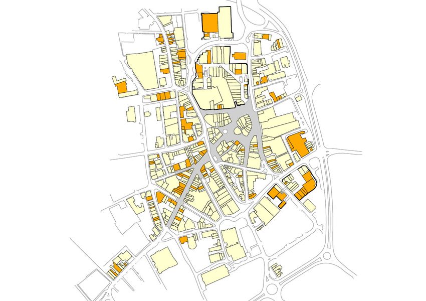
Commercial Yields
The commercial yield on non-domestic property data is obtained from the Valuation Office Agency (July 2008) and is deemed a reliable indicator of general health as it
reflects investor confidence in a centre. The yield value is calculated by determining the open market rent of a unit as a percentage of its capital value. A low yield
generally indicates that a town is considered to be attractive and, as a result, be more likely to attract investment than a town with high yields. The data can also
demonstrate the confidence of investors in the long-term profitability of the centre for retail, office and other commercial developments. It should be noted that the 2008
data is the most up-to-date information from the Agency as no further updates have been produced.

Land Values
The land value of a site and the length of time it may have remained undeveloped can provide an important indication as to how flexible the planning policies on the site
can be and can help to inform planning decisions. However, it should be recognised that each parcel of land is often subject to a unique set of circumstances, for example
physical or ownership constraints, which could affect the likelihood of the land being developed.

Pedestrian Footfall
The analysis of the pedestrian footfall of a town centre is deemed as a key indicator of the vitality of the area. It is measured by recording the number and movement of
people in different areas of a centre.

Accessibility
The accessibility of a centre is a key measure of its vitality and viability, noting that this will be determined by the ease and convenience of access by a choice of means of
travel (including the quality, quantity and type of car parking; the frequency and quality of public transport services; and the range of customer origins served), quality of
provision for pedestrians, cyclists and disabled people and the ease of access from the main arrival points to the main attractions in the centre.

Customer and Residents’ Views and Behaviour
Regular surveys are often used by local authorities to obtain the views of customers and residents in their area, with the findings often helpful for monitoring and
evaluating the effectiveness of town centre improvements and for identifying future priorities. The survey can either be undertaken in the town centre or at home, with
WYG regularly appointing survey companies to determine the pattern of retail and leisure expenditure patterns in the local area and to establish the degree of linked trips.

                                                                                                                                                                                  4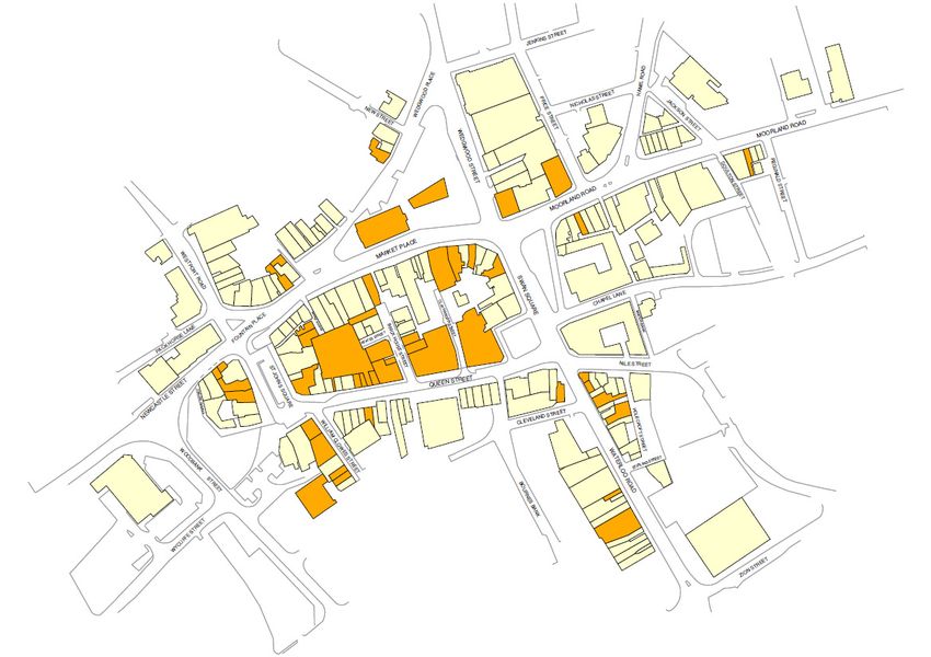
Perception of Safety and Occurrence of Crime
The perception of the safety and security of a town centre can include a number of indicators, for example: the number of CCTV systems in operation; the crime levels;
the police presence in the street; whether there is a Pub Watch/Street Watch scheme in operation; and any other issues associated with the night-time economy.

Town Centre Environmental Quality
The final indicator requires a review of the quality of the town centre environment, including an assessment of the positive and negative factors affecting environmental
quality, such as the provision of trees, open spaces and landscapes, as well as potential problems, including noise, clutter, litter and graffiti.

                                                                                                                                                                            5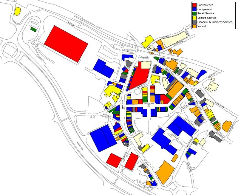
Health Check Indicator – Overall Diversity of Main Town Centre Uses
Table 1: Diversity of Use Figures of the Centres
       August 2013               Convenience                Comparison            Retail Service          Leisure Service   Financial/Business Service         Vacant
                                    No.          %          No.         %         No.         %           No.        %         No.            %          No.        %
       Stoke City Centre             23        4.1%         192       34.0%        69       12.2%         105      18.6%        64          11.3%        111      19.7%
    Burslem Town Centre               7        4.0%         39        22.2%        17       9.7%          43       24.4%        24          13.6%         46      26.1%
     Fenton Town Centre               5        12.8%        10        25.6%        4        10.3%          7       17.9%        2            5.1%         11      28.2%
    Longton Town Centre              20        8.8%         69        30.3%        32       14.0%         26       11.4%        29          12.7%         52      22.8%
      Meir Town Centre                9        12.9%        18        25.7%        13       18.6%         18       25.7%        5            7.1%         7       10.0%
      Stoke Town Centre              15        8.0%         39        20.9%        15       8.0%          38       20.3%        22          11.8%         58      31.0%
    Tunstall Town Centre             14        6.8%         56        27.2%        27       13.1%         41       19.9%        20           9.7%         48      23.3%
       Centres Average               13        6.1%         60       28.6%         25      11.9%          40       19.0%        24          11.4%         48      22.8%
        UK Average*                   -        8.1%          -       33.1%          -      13.8%           -       22.1%         -          11.0%          -      11.5%
Source: Site Visit, August 2013, *UK Average Figure, Goad, July 2013 (taken from Full Category Report averages)

Table 2: Floorspace Figures of the Centres
       August 2013               Convenience                Comparison            Retail Service          Leisure Service   Financial/Business Service         Vacant
                                   Sq.m          %         Sq.m         %        Sq.m         %         Sq.m         %        Sq.m            %          Sq.m           %
       Stoke City Centre           8,740       5.6%       79,230      50.5%      6,880      4.4%        27,610     17.6%      11,100         7.1%        23,330    14.9%
    Burslem Town Centre            1,110       3.2%        8,240      23.4%      1,710      4.9%        11,190     31.8%      3,750         10.7%        9,180     26.1%
     Fenton Town Centre              886       9.2%        2,639      27.4%       429       4.5%         1,169     12.2%       244           2.5%        4,251     44.2%
    Longton Town Centre            15,520      25.9%      20,000      33.3%      3,460      5.8%         5,620      9.4%      4,680          7.8%        10,740    17.9%
      Meir Town Centre             1,656       19.8%       2,277      27.2%       986       11.8%        1,744     20.8%       483           5.8%        1,220     14.6%
      Stoke Town Centre            12,310      26.8%       8,120      17.7%      1,720      3.7%        10,800     23.5%      3,660          8.0%        9,340     20.3%
    Tunstall Town Centre           11,270      23.3%      16,460      34.1%      2,440      5.1%         7,610     15.8%      3,170          6.6%        7,340     15.2%
       Centres Average             7,356      14.1%       19,567     37.6%       2,518      4.8%         9,392     18.0%      3,870          7.4%        9,343     21.9%
        UK Average*                  -        14.6%          -       36.6%         -        7.4%           -       23.0%        -            8.4%          -       9.3%
Source: Site Visit, August 2013, *UK Average Figure, Goad, July 2013 (taken from Full Category Report averages)

                                                                                                                                                                            6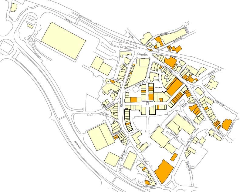
National and Independent Retailers - Top Retailers (Experian Goad)
Table 3: Top Comparison Retailers in the Centres
                         Stoke        Burslem Fenton                 Longton         Meir   Stoke   Tunstall   Crewe   Stafford   Newcastle-under-Lyme   Congleton
       Retailer
                          City                                                              Town
         Argos                          -       -                                   -       -
           BHS                               -             -            -            -       -        -                 -                -                -
          Boots                                           -                               -        -
          Burton                             -             -                        -       -                                         -                -
  Carphone Warehouse                         -             -                        -       -        -
          Clarks                             -             -            -            -       -        -                                                 -
         Clintons                            -             -            -            -       -        -
       Debenhams                             -             -            -            -       -        -        -         -                -                -
     Dorothy Perkins                         -             -                        -       -
           H&M                   -            -             -            -            -       -        -        -         -                -                -
           HMV                               -             -            -            -       -        -        -         -                -                -
     House of Fraser             -            -             -            -            -       -        -        -         -                -                -
       John Lewis                -            -             -            -            -       -        -        -         -                -                -
    Marks & Spencer                          -             -            -            -       -        -                                 -
        New Look                             -             -            -            -       -        -                                                 -
           Next                              -             -                        -       -                                                         -
            O2                               -             -            -            -       -        -                                                 -
        Phones 4U                            -             -            -            -       -        -                                                 -
         Primark                             -             -            -            -       -        -        -         -                -                -
       River Island                          -             -            -            -       -        -                                 -                -
        Superdrug                            -             -                        -       -
         TK Maxx                             -             -            -            -       -        -                                 -                -
    Topman/Topshop                           -             -            -            -       -        -                                 -                -
        Vodafone                             -             -            -            -       -        -                                 -                -
       Waterstones                           -             -            -            -       -        -                                 -                -
        WHSmith                              -             -            -            -       -        -
        Wilkinson                            -             -                        -       -        -                                                 -
          Total                 24             1            0             8            1     0         5        21       20               13                8
Source: Experian Goad Key Major Retailers List and WYG research via store finders search

                                                                                                                                                                7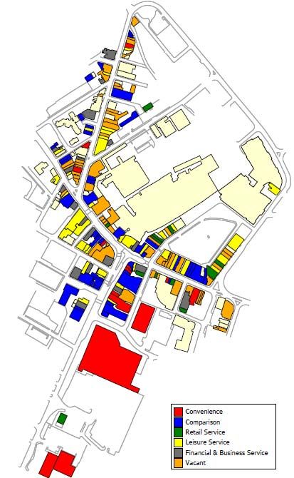
Health Check Indicator – Retailer Requirements
There are a total of 152 retail and leisure operators seeking to locate within the City of Stoke-on-Trent authority area (data from EGi, 4th November 2013), including 43
clothing stores, 28 restaurants and cafes, 20 take aways outlets and 12 sports operators. In particular, EGi identified that there are requirements from several high street
chains such as B&M Bargains (which is seeking a store with a size area of 929 – 2,787 sq.m), Farmfoods (557 – 743 sq.m) and River Island (650 – 1,394 sq.m).

                                              Health Check Indicator – Vacant Street – Level Property
Table 4 indicates the number of vacant units in each of the centres. It is evident that all of the centres (with the exception of Meir) have an above average proportion of
vacant units compared to the overall UK figure, with acute vacancies identified in Burslem, Fenton and Stoke Town. Similarly, the amount of vacant floorspace in each of
the centres is significant, with the overall centre average more than double the national figure.

Table 4: Vacant Units
              Centre                         Total No. of Vacant Outlets            % of Outlets         Total Amount of Vacant Floorspace (Sq.m)    % of Floorspace
            Stoke City Centre                               111                         19.7%                             23,330                           14.9%

          Burslem Town Centre                                46                         26.1%                             9,180                            26.1%

          Fenton Town Centre                                 11                         28.2%                             4,251                            44.2%

          Longton Town Centre                                52                         22.8%                             10,740                           17.9%

            Meir Town Centre                                 7                          10.0%                             1,220                            14.6%

           Stoke Town Centre                                 58                         31.0%                             9,340                            20.3%

          Tunstall Town Centre                               48                         23.3%                             7,340                            15.2%
            Centres Average                                  48                         22.8%                             9,343                            21.9%
             UK Average*                                     -                          11.5%                               -                               9.3%
Source: Site Visit, August 2013, *UK Average Figure, Goad, July 2013 (taken from Full Category Report averages)

                                                                                                                                                                               8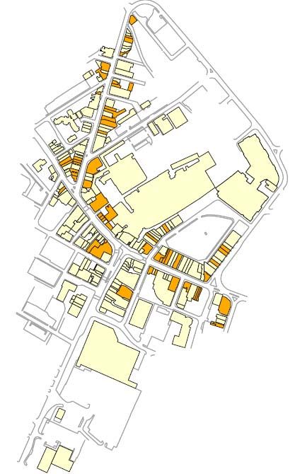
STOKE CITY CENTRE HEALTH CHECK ASSESSMENT
Centre Overview
Stoke City centre is the principal economic and social centre in the administration area. It performs a regional role in the shopping hierarchy, with the adopted Core
Strategy identifying that it is the largest retail destination in North Staffordshire and South Cheshire. The centre is also an important leisure and business location, acting
as the main focus for economic, educational and cultural activities within the local area.

The main focus of retailing is concentrated along the pedestrianised routes of Lamb Street, Market Square and Tontine Street. These are designated as being within the
Core Strategy-defined primary shopping area, with the indoor Intu Potteries Centre also acting as the key anchor destination for shoppers within the city centre. The
secondary shopping areas of the city include Stafford Street, Piccadilly and Pall Mall, with these streets tending to accommodate a higher proportion of independent
traders. To the west of the city centre are several large out-of-centre retail and leisure parks off Etruria Road and Corbridge Road, namely Century Retail Park, Octagon
Retail Park, Festival Retail Park and Festival Heights Retail Park.

As Experian’s latest Goad survey of the centre was completed in November 2012, a site visit of Stoke City has been undertaken to update the health check analysis to
ensure it is compiled using the most up-to-date diversity of use and floorspace figures. This information has then been used to compare the relevant data with the
national average figures and, where necessary, to identify any potential issues with the centre. The survey identified that there was a total of 564 units within Experian
Goad’s defined city centre boundary, comprising a total gross floorspace of 156,890 sq.m. We have utilised the centre boundary as identified by Experian Goad for our
analysis in order to consider an extensive area and to allow a direct comparison with the national average figures (which are calculated using Experian Goad’s assessment
of the boundary of each centre).

                                                                                                                                                                              1
Photographs of Stoke City Centre (August 2013)
Photograph 1 (top left): Site of the CBD scheme, Broad Street
Photograph 2 (top centre): Vacant units, Hope Street
Photograph 3 (top right): Site of the City Sentral scheme, Hanley Shopping Centre
Photograph 4 (bottom left): Lamb Street & Intu Potteries Centre
Photograph 5 (bottom centre): Piccadilly
Photograph 6 (bottom right): Tontine Street
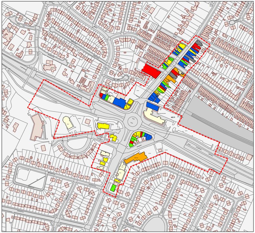
2Figure 1: Land Use Plan for Stoke City Centre (August 2013)
3Figure 2: Land Use Plan for Stoke City Centre (August 2013)
4Health Check Indicator – Diversity of main town centre uses
Table 1: Previous Number of Units in Stoke City centre (2005) Table 2: Previous Floorspace in Stoke City centre (2005)
Previous Number of Units Previous Floorspace
No. Stoke City centre UK Sq.m Stoke City centre UK
Convenience 26 4.7% 9.2% Convenience - 12.0% 17.0%
Comparison 282 50.8% 48.0% Comparison - 64.2% 53.1%
Services 138 24.9% 31.1% Services - 12.8% 20.8%
Vacant 100 18.0% 10.3% Vacant - 9.7% 7.8%
Total 555 100% 100% Total 100% 100%
Source: North Staffordshire Retail and Leisure Study 2005 Source: North Staffordshire Retail and Leisure Study 2005, Floorspace figures based on
Nb. Excluding miscellaneous Experian Goad data (January 2005), Nb. Excluding miscellaneous
Table 3: Existing Number of Units in Stoke City centre (August 2013) Table 4: Existing Floorspace in Stoke City centre (August 2013)
Existing Number of Units Existing Floorspace
No. Stoke City centre UK Sq.m Stoke City centre UK
Convenience 23 4.1% 8.1% Convenience 8,740 5.6% 14.6%
Comparison 192 34.0% 33.1% Comparison 79,230 50.5% 36.6%
Retail Service 69 12.2% 13.8% Retail Service 6,880 4.4% 7.4%
Leisure Service 105 18.6% 22.1% Leisure Service 27,610 17.6% 23.0%
Financial and Business Service 64 11.3% 11.0% Financial and Business Service 11,100 7.1% 8.4%
Vacant 111 19.7% 11.5% Vacant 23,330 14.9% 9.3%
Total 564 100.0% 100% Total 156,890 100.0% 100%
Source: Site Survey & Experian Goad Data – August 2013 and UK average from the Source: Site Survey & Experian Goad Data – August 2013 and UK average from the
Experian Goad Category Report (July 2013) Experian Goad Category Report (July 2013)
Nb. This table is based on the Experian Goad city centre boundary Nb. This table is based on the Experian Goad city centre boundary
5Health Check Indicator – Diversity of main town centre uses
Convenience Goods Units
The level of convenience goods provision in Stoke city centre is below the national average, both in terms of the number of units and the quantum of floorspace. The previous
2005 North Staffordshire Study had identified that there were only 26 stores selling principally convenience goods in Stoke City, with a particular shortfall in the number of
greengrocers and butchers. Since then, the number of convenience goods businesses has declined even further, with the site visit in August 2013 identifying that there was a
total of just 23 units. There are no major foodstores within the centre boundary, with the exception of the M&S foodhall and the Iceland store on Charles Street. The remaining
convenience goods provision is generally provided for by local independent convenience traders which tend to be small in scale and are more likely to meet the everyday top-up
needs of shoppers in the area, rather than provide adequate provision for residents to undertake their main food shopping. The permanent indoor market at the Intu Potteries
Centre is the largest convenience unit in Stoke City centre (but it also sells a large proportion of comparison goods) and again although it comprises only local traders, the
Centre is a popular resource, with the in-street survey identifying that 43% of the respondents intended to visit the market on the day of their visit.
The lack of any large foodstore in Stoke City contrasts with the provision outside the centre boundary, at the out-of-centre retail parks, including the Sainsbury’s on Etruria Road
and the Morrisons store at Festival Park. The Tesco unit on New Hall Street, for example, was formerly the only major foodstore operator within the centre boundary, though
the operator is now located in a new Extra store on Clough Street to the west of the city and the remaining unit now operates as a Go Outdoors.
Comparison Goods Units
The amount of comparison goods floorspace in Stoke City reflects its city centre status and the level is significantly above the national average (50.5% compared to 36.6%).
The centre accommodates a high proportion of national retailers which tend to operate from the largest units within the primary shopping area, including BHS, Debenhams,
Marks and Spencer, Primark and TKMaxx. This provision is also complemented by a variety of independent retail traders, with a number operating within the indoor and outdoor
markets at Market Square, Fountain Square and Hinde Street car park. However, it is evident that there has been a reduction in the amount of comparison goods floorspace (by
2,870 sq.m) in the 10 months since the previous Experian Goad survey in November 2012, with several stores now vacant, including the Disney and Schuh stores at the Intu
Potteries Centre. The former Blacks outdoor store in Hanley Shopping Centre on Old Hall Street is also due to be demolished as part of the City Sentral scheme, though the
Argos and B&M Bargains stores in this location remain open for trading for the time being. The extensive retail parks (Century, Octagon, Festival and Festival Heights) to the
west and north-west of Stoke City (and outside of the centre boundary) also accommodate numerous bulky goods national operators, including B&Q, Currys and Next Home.
6Service Units
There is an under-provision of retail services in Stoke City compared to the national average, with the 69 units comprising a total floorspace of 6,880 sq.m. Notwithstanding this,
the health and beauty sector is particularly dominant in the centre and, with the exception of two units, all of the 47 businesses are operated by local independent traders.
There are also five opticians (including Specsavers and Vision Express) and five travel agents (including Co-op Travel and Thomas Cook) in the city, with a Post Office located in
the Intu Potteries Shopping Centre.
The leisure services in the centre includes restaurants, cafes, bookmakers and public houses which are within Use Classes A3, A4, A5, C1 and D2. The sector is under
represented in Stoke City compared to the national average and there has also been a decline more recently, both in terms of the number of units and amount of floorspace,
with the closure of several cafes and bars since the previous Experian Goad survey in November 2012. Despite this, there is still a particular cluster of evening economy uses,
notably bars and nightclubs, on Foundry Street and Stafford Street. The cultural quarter area of the city also includes the Ambassador Theatres on Bagnall Street and Piccadilly,
with the Core Strategy noting that whilst the development of this hub has been a success, it needs to be further developed and its appeal widened to embrace other creative
activities.
The proportion of financial and business service units and floorspace in the centre reflects the respective national average figures, with the 64 units comprising a variety of Class
A2 uses including 15 retail banks, 13 legal firms and 13 financial advisors.
Non-Retail Units
The centre also accommodates a mix of other administrative and tourist uses which reflects its role as an important regional centre in the local area and complements its
existing retail and service offer. There are 19 offices and six government buildings in Stoke, as well as four medical services, three churches, two educational institutions, a
museum and an art gallery.
7Health Check Indicator
The Amount of Retail, Leisure and Office Floorspace in Edge-of-Centre and Out-of-Centre Locations
In addition to the retail and service provision in Stoke City, there is also a significant amount of large warehouse units which are located in out-of-centre locations to the west of
the city centre off Etruria Road and Corbridge Road. These facilities act as key standalone destinations for shoppers in the local area, with the Core Strategy recognising that
they accommodate a type of service which could not reasonably be accommodated within the traditional city centre core, notably bulky goods retailers.
Century Retail Park is located on Etruria Road (A5010) and although it is the closest retail park to the city centre, WYG noted that there appeared to be a lack of linked trips
between the two destinations. This may be attributable to the lack of operators which are located there, with the retail park currently only comprising a Staples, Burger King and
two vacant units. A Sainsbury’s foodstore and petrol filling station are located adjacent to the retail park. A Premier Inn is also currently being developed on the opposite side of
Etruria Road, with the Tesco Extra store on Clough Street within walking distance. It has a total floorspace of approximately 3,939 sq.m (gross).
Octagon Retail Park is slightly further out from the city centre along Etruria Road and is located adjacent to the Century Retail Park. It appeared to be trading well on the day
of the site visit by WYG, with its mix of retail and leisure units, namely a BHS, CSL, DFS, Mammas and Pappas, Mecca Bingo, Next Home and Starplan bedroom furniture store,
likely to attract shoppers from a wide catchment area. The former JJB Stores unit is now vacant, with the retail park having a total floorspace (excluding the Mecca Bingo) of
approximately 10,909 sq.m (gross).
Festival Park off Cobridge Road (A53) is the largest retail and leisure park in the local area, with the 16 units offering a variety of traditionally high street operators in the
clothing and footwear sector (including New Look, Next and Outfit), household goods (Argos, B&Q and Carpet Right) and several leisure service outlets (including McDonalds
and Pizza Hut). The former Comet store is now vacant. The location of the Morrisons foodstore and petrol filling station to the north of the retail park is also likely to attract
additional shoppers and encourage them to make linked trips between the two facilities. The retail park has a total goods floorspace (excluding the leisure outlets) of
approximately 13,956 sq.m (gross).
The Festival Heights Retail Park is located to the north of Festival Park and comprises six commercial units, namely a Currys, Halfords, Harveys, KFC, M Club gym and Pets
at Home store. The retail park includes 424 customer car parking spaces and appeared to be performing well on the day of the site visit. It has a total goods floorspace
(excluding the KFC and M Club gym) of approximately 4,881 sq.m (gross).
8Photographs of the Retail Parks (August 2013)
Photograph 7 (top left): Vacant unit (former Apollo 2000), Century Retail Park
Photograph 8 (top centre): Currys, Festival Heights Retail Park
Photograph 9 (top right): Festival Heights Retail Park
Photograph 10 (bottom left): Festival Retail Park
Photograph 11 (bottom centre): Morrisons, adjacent to Festival Retail Park
Photograph 12 (bottom right): Octagon Retail Park
9Health Check Indicator – Retailer Representation and Retailer Demand
Retailer Requirements (EGi)A total of 44 retail and leisure operators are currently seeking potential business premises in the centre, comprising seven convenience, 25
comparison and 12 leisure service operators (search dated 5th November 2013). EGi identifies that the majority of the requirements are from national operators, including
Budgens (which is seeking a store with a sales area of between 232 – 929 sq.m), Pound Bakery (65 – 139 sq.m) and Starbucks (139 – 186 sq.m).
Health Check Indicator – Shopping Rents
A review of the current property values of vacant units in Stoke city via Estates Gazette and relevant local agents details identified a variation in the current rental values (nb.
total unit retail floorspace rental value and not Zone A rental value), dependent on their location and building type. The values ranged from approximately £37/sq.m (274 sq.m,
£10,000 per annum) on Piccadilly to the more centralised units on Lamb Street (£427/sq.m – 69 sq.m, £29,500 sq.m) and within the Intu Potteries Centre (£280/sq.m – 125
sq.m, £35,000 per annum). The average rental value for retail units in Stoke city is approximately £126/sq.m which is the highest rental figure of the centres which WYG has
assessed in this Study.
10Health Check Indicator – Vacant Street-Level Property
In August 2013, WYG identified that the 111 vacant units in Stoke city accounted for 23,330 sq.m of the total floorspace. The number of vacant outlets (19.7%) is significantly
above the national average (11.5%), with the proportion of vacant floorspace (14.9%) also well above the UK average figure (9.3%). Whilst there are very few vacant units
within the defined primary shopping area, there are particular parts in the centre where vacancies are concentred, notably along Piccadilly (a secondary shopping area) and in
the smaller units within the peripheral areas on Hope Street, New Hall Street and Marsh Street South. Although there has been a slight improvement in the level of vacancies
since November 2012 when there was 116 vacancies, there has also been the recent closure of several national retailers in the city centre, including the Republic and Disney
Store in the Intu Potteries Centre and the Blacks outdoor shop on Old Hall Street. It should be noted that the 20 vacant units which are located within the Hanley Shopping
Centre (with a floorspace of 5,060 sq.m) will be demolished as part of the City Sentral scheme, including the Blacks store. If these units are removed the proportion of vacant
units in the centre is reduced to 17.0% and the amount of vacant floorspace is lowered to 11.8%, though these figures still remain above the national average.
Photograph 13: Vacant units on Piccadilly Photograph 14: Former Blacks outdoor shop, Old Hall Street Photograph 15: Vacant unit, Pall Mall
11Figure 3: Vacancies in Stoke City Centre (August 2013)
12Figure 4: Vacancies in Stoke City Centre (August 2013)
13Health Check Indicator – Pedestrian Footfall
An assessment of the general pedestrian flows in the city centre was noted during the site visit on Wednesday the 7th August 2013. It was evident that the greatest levels of
activity were within the Intu Potteries Shopping Centre and surrounding streets, notably along the pedestrianised areas of Market Square and Piccadilly, with lower levels
recorded on the more peripheral streets and to the north. Intu Potteries has provided details of pedestrian footfall in the centre and these levels have declined from a peak of
approximately 14 million in 2010 to a figure of 10.9 million for 2013 (as predicted).
Health Check Indicator – Accessibility
Road Access: The city centre boundary broadly follows the route of Potteries Way (the A50) and this provides direct access to the A53 and the A500 (Queensway). Stoke City
is located approximately 4.5km to the south east of Tunstall, 6.5km to the north west of Longton and 4.5km to the east of Newcastle-under-Lyme town centre.
Car Parking: The main city centre car parks are located within the multi-storey facilities at the Intu Potteries Centre (1,200 spaces), Bethesda Street (625 spaces), Burton Place
(457 spaces) and New Hall Street (approximately 200 spaces), with Park and Ride facilities also located on Broad Street (105 spaces) and Hinde Street (457 spaces).
Additional surface level car parking is also located at Sampson Street (220 spaces), Clough Street (170 spaces), Glass Street (90 spaces), Huntbach Street (75 spaces) and Pall
Mall (28 spaces). The parking charges (off-street) range from £0.90 for up to an hour, £2.00 for up to two hours and between £3.00 to £7.50 for all day parking, on street
parking is more expensive. The Tesco Extra customer car park is located out of the centre boundary and provides free customer parking for a maximum of two hours.
Public transport: The new bus station off Lichfield Street was opened in March 2013, with the former bus facility to be demolished as part of the later phases of the City
Sentral scheme. The nearest railway station is located off Leek Road, approximately 3km to the south west of Stoke City centre. Both offer services to the wider sub-region,
including to Newcastle-under-Lyme, Stafford and Crewe, and the wider national network.
An in-street survey was undertaken in the city centre by NEMS Market Research Limited in July 2013. The results of the survey help to provide an understanding of customer
and residents’ views and behaviours. It identified that a total of 47% of the visitors to the city centre had travelled there by car, with 37% using either a bus, minibus or coach
and 12% walked into the centre. The Intu Potteries car park was the most popular place to park, followed by the Tesco Extra customer car park on Clough Street and the on-
street spaces in the centre. Whilst most of the respondents identified that the cost of car parking was too expensive (40%), a high proportion (27%) also identified that they
parked for free and 24% stated that they were satisfied with the cost.
14Health Check Indicator – Customer and Residents’ Views and Behaviour
The in-street visitors and household survey results identify that Stoke City scores positively on a number of the indicators. When asked what was the main reason why they
were in Stoke city, 41% of the respondents stated that they were there to go clothes or shoes shopping, (which unsurprisingly is the highest response of those interviewed in
the authority area by a significant margin), 16% were there to access financial services and 10% were there to browse. In addition, 80% of the respondents stated that it was
their first choice destination for clothing and other non-food goods shopping. This reflects its range of high street operators, including Debenhams, Primark and TKMaxx. In
contrast, a significant majority (92%) of the respondents stated that they did not intend to undertake their main food and grocery shop whilst in Stoke City that day, with 57%
stating that they would never visit the centre to undertake this type of shopping. This was the highest proportion of any of the in-centre surveys and may be attributed to the
location of many of the largest foodstores outside of the city centre boundary.
Since 2005, the average time that visitors spend in Stoke City has reduced, with the majority of respondents in 2013 (51%) intending to stay for between one and two hours,
followed by 25% of visitors stating that they intended to stay for less than an hour. In contrast, the 2005 Study had identified that 58% of the visitors were to stay for between
two and four hours, 31% were to stay for between one and two hours and only 3% were visiting for less than half an hour. In terms of the frequency of their visit however,
most of the respondents (41%) stated that they visited Stoke city about as frequently as five years ago, 21% stated that they visited more frequently and 14% visited less
frequently.
When asked how they would compare Stoke city to other undefined centres, it was rated ‘better’ or ‘much better’ by a significant proportion of the respondents, notably in terms
of the choice of high street names (64%), the choice of shops (62%) and the range of financial services (58%). One aspect where Stoke City scored less favourably was in
terms of car parking prices, with 19% of the respondents stating that they thought that cheaper parking would improve Stoke City and make it more attractive. Overall however,
37% of the respondents did not mention any particular type of shops or services they would like to see more of in Stoke City, which is the highest proportion of those
interviewed in any of the centres by a significant margin. The survey identified that 43% of the respondents intended to visit the indoor market at the Intu Potteries Centre, with
17% planning to visit the outdoor markets at Market Square and Fountain Square (8%).
The household survey (of the overall study area) identified that, unsurprisingly, Stoke City was the most popular centre for the respondents to visit (82%), with 21% of the
individuals stating that they visited the city as least once a month and 17% visited at least once a week. When asked why they do not visit the city centre, 12% of the
respondents referred to the inconveniently located car parking, with other popular responses identifying the environmental quality of the centre (10%) and the lack of choice
and range of shops (9%).
15Health Check Indicator – Perception of Safety and Occurrence of Crime
In June 2013, there were 146 incidences of reported crime in the city centre (an improvement from 184 in May 2013 and 155 in April 2013), with 48 reports of anti-social
behaviour and 32 incidents of shoplifting (information via www.police.uk). CCTV operates in the city centre, with the 39 cameras monitored 24 hours a day. A high proportion of
the respondents to the in-street survey (26%) identified that they felt that the day time safety of Stoke City was ‘much better,’ or ‘better’ than other centres, though this
reduced to 17% when they were asked about the evening/night safety in the centre.
Health Check Indicator – Town Centre Environmental Quality
Stoke City contains a variety of modern and traditional buildings, with the majority of the southern part of the centre, which includes Albion Street and Percy Street, located
within the conservation area boundary. This historic core has a very distinctive and mixed architectural character, with many of the key landmark Edwardian and Victorian
buildings located next to units which have a more modest façade.
Overall, the standard of cleanliness in the centre is good, with little evidence of litter, graffiti or fly-posting. Several of the streets in the centre, including along Piccadilly and
Tontine Street, have also recently undergone public realm works by the Council as part of a £7.2m scheme to improve the overall environmental quality of the city. This has
enabled the installation of new paving slabs and seating areas which have made these areas appear more pedestrian-friendly. However, despite these enhancements, several
areas of the centre do still appear neglected. This is a particular issue in the peripheral parts of the city, notably in the northern areas on Hope Street and in numerous other
locations outside the primary and secondary shopping areas which have a high concentration of vacancies. In addition, many of the shops have installed roller shutters which
make these units look abandoned when the store is closed. These areas would therefore benefit from additional investment to their frontages and surrounding public spaces.
Despite this, the overall physical condition of the centre is evident having regard to the in-street survey results, with 53% of the visitors interviewed stating that they believed
that the centre environment was ‘better’ or ‘much better’ than other assessed centres. In addition, 46% of the respondents stated that they felt that the cleanliness, and 26%
considered that public art, in Stoke City was superior to the other centres.
16Summary
On the basis of the above analysis, it is clear that Stoke city plays an important role as the key commercial and leisure centre in the region. It has many strengths and
weaknesses, as summarised below:
• It contains a high proportion of multiple retailers which attract shoppers from a wide catchment area, with the retail and leisure parks to the west of the centre
also providing some bulky goods provision;
• There is a shortfall in the amount of convenience retailers within the city centre boundary, though additional national multiple provision to cater for main food
shopping needs is available at the Morrisons, Sainsbury’s and Tesco stores which are located outside the centre boundary, to the west of the city;
• There is a strong level of public and private sector-led confidence in the centre, as demonstrated by the emerging City Sentral, Central Business District and Intu
Potteries (leisure-led) schemes;
• The environmental quality of the centre is good, though it is evident that many of the peripheral areas require additional investment to improve their overall
physical condition;
• The centre is currently ranked 70th in the national retail hierarchy and has experienced a fall of 17 places between 2006 and 2013;
• The level of vacancies is significantly above the national average, with particular concentrations recorded in several of the secondary and outlying areas of the
centre;
• The in-street visitors survey identified that visitors to the city intended to spend far less time there than in 2005; and
• The surveys also indicate that overall, there is good level of satisfaction with the facilities in the city centre, with the cost location of car parking identified as the
main issue which needed to be addressed.
In summary, Stoke City displays several strong vitality and viability indicators and it compares extremely favourably with the other key centres in the authority area. It is evident
that the main strength of the centre is the quality and quantity of the national operators which are accommodated there, with the City Sentral scheme also set to attract
additional high street retail and leisure operators if it is implemented. The main weakness is the high level of vacancies in the secondary locations of the centre and the poor
environmental quality of several of the peripheral areas. The key opportunities for Stoke City are the three new leisure, retail and office-led developments, whilst the main threat
is that vacancies could increase as operators may choose to relocate to the southern areas of the centre towards the City Sentral scheme.
17BURSLEM TOWN CENTRE HEALTH CHECK ASSESSMENT
Centre Overview
Burslem town centre is located approximately 2.5km to the north of Stoke City centre and 2km to the south of Tunstall town centre. The adopted Core Strategy identifies
that Burslem is the fifth largest centre in the City of Stoke-on-Trent and is ranked above Fenton and Meir within the centres hierarchy. Burslem was historically at the
heart of the local region’s ceramic industry, though many of these factories have since closed and have either been demolished or remain vacant. Despite this, the Core
Strategy identifies that the town centre still plays a key role as a historic and cultural destination, in addition to providing local convenience shopping and services.
The main focus for retail and service activities in Burslem is along the primary and secondary shopping areas on Queen Street, St John’s Square and Market Place.
Additional retail provision is available at the B&M Bargains on Waterloo Road and the Home Bargains store on Wycliffe Street which are both located outside of the
defined town centre boundary. Burslem also accommodates the Queens Theatre on Wedgwood Street and a Council office on Brick House Street.
A site visit to Burslem identified that there was a total of 176 units within Experian Goad’s defined town centre boundary, comprising a total gross floorspace of 35,180
sq.m. WYG have utilised the centre boundary as identified by Experian Goad rather than previous plan boundaries.
18Photographs of Burslem Town Centre (August 2013)
Photograph 16 (top left): Queen Street/Waterloo Road
Photograph 17 (top centre): Queen Street
Photograph 18 (top right): St John’s Square
Photograph 19 (bottom left): B&M Bargains, Waterloo Road
Photograph 20 (bottom centre): Burslem local centre office, Brick House Street
Photograph 21 (bottom right): Market Place
19Figure 5: Land Use Plan for Burslem Town Centre (August 2013)
20Table 5: Previous Number of Units in Burslem town centre (2005) Table 6: Previous Floorspace in Burslem town centre (2005)
Previous Number of Units Previous Floorspace
No. Burslem UK Sq.m Burslem UK
Convenience 10 7.3% 9.2% Convenience - 18.0% 17.0%
Comparison 48 34.8% 48.0% Comparison - 36.9% 53.1%
Services 41 29.7% 31.1% Services - 21.6% 20.8%
Vacant 36 26.1% 10.3% Vacant - 22.0% 7.8%
Total 138 100% 100% Total - 100% 100%
Source: North Staffordshire Retail and Leisure Study 2005 Source: North Staffordshire Retail and Leisure Study 2005, Floorspace figures based on
Nb. Excluding miscellaneous Experian Goad data (January 2005), Nb. Excluding miscellaneous
Table 7: Existing Number of Units in Burslem town centre (August 2013) Table 8: Existing Floorspace in Burslem town centre (August 2013)
Existing Number of Units Existing Floorspace
No. Burslem UK Sq.m Burslem UK
Convenience 7 4.0% 8.1% Convenience 1,110 3.2% 14.6%
Comparison 39 22.2% 33.1% Comparison 8,240 23.4% 36.6%
Retail Service 17 9.7% 13.8% Retail Service 1,710 4.9% 7.4%
Leisure Service 43 24.4% 22.1% Leisure Service 11,190 31.8% 23.0%
Financial and Business Service 24 13.6% 11.0% Financial and Business Service 3,750 10.7% 8.4%
Vacant 46 26.1% 11.5% Vacant 9,180 26.1% 9.3%
Total 176 100.0% 100% Total 35,180 100% 100%
Source: Site Survey & Experian Goad Data – August 2013 and UK average from the Source: Site Survey & Experian Goad Data – August 2013 and UK average from the
Experian Goad Category Report (July 2013) Experian Goad Category Report (July 2013)
Nb. This table is based on the Experian Goad town centre boundary Nb. This table is based on the Experian Goad town centre boundary
21Health Check Indicator – Diversity of main town centre uses
Convenience Goods Units
There is a clear shortfall in terms of the proportion of convenience goods outlets (4.0% against a national average of 8.1%) and floorspace (3.2% compared to 14.6%) in
Burslem, with the seven stores accounting for only 1,110 sq.m of the total floorspace. There is no large-scale provision of facilities in the centre, with the existing stores
(including a Lifestyle Express, a bakers, butchers, Farmfoods frozen goods store and greengrocers) only likely to perform a top-up role for residents within a local catchment
area. The B&M Bargains and Home Bargains stores also sell a limited range of food goods, though they are classed as comparison retailers by Experian Goad for the purposes of
this analysis.
Comparison Goods Units
The comparison goods sector only accounts for 22.2% of the outlets and 23.4% of the floorspace in Burslem, with both figures below the national average rates. Despite this, it
is noted that the town centre does accommodate a diverse range of businesses including six hardware and household goods retailers, four gift shops, four ladies clothing stores
and three pharmacies. There are also several national high street chains in Burslem, including Boots and Poundstretcher, though the majority of units are operated by local
independent retailers. The largest stores (the B&M Bargains and Home Bargains) are not included within the town centre boundary.
Service Units
There is an under-provision of retail service facilities in Burslem, with the 17 units accounting for only 1,710 sq.m of the floorspace in the town centre. In addition, following the
closure of the Co-operative Travel unit on Market Place, all of the retail service outlets (with the exception of the Post Office) are occupied by local independent traders
including seven health and beauty units, two opticians, a travel agents and a dry cleaners.
The 43 leisure services in Burslem town centre occupy 11,190 sq.m of the floorspace and include 13 public houses, 12 take away outlets, 7 restaurants and the Queens Theatre
on Wedgwood Street. The proportion of both leisure service units (24.4%) and the amount of floorspace (31.8%) are above the respective national average figures of 22.1%
and 23.0%. There has been a slight increase in the provision of leisure facilities since the previous Experian Goad survey in November 2011, from 41 units and 9,590 sq.m of
floorspace.
In terms of financial and business services in Burslem, the proportion of outlets occupied by such uses (13.6%) is above the national average figure (11.0%), whilst the
proportion of floorspace (10.7%) is also above the national average level (8.4%). The majority of units are operated by insurance and legal businesses, with several high street
banks in the town centre, including Lloyds TSB, Nationwide and Nat West.
22Non-Retail Units
In addition to the retail and service provision on offer within the centre, there are a number of non-retail uses, including seven offices and the Burslem local centre Council office
on Brick House Street. There are two churches which are located on Moorland Road and Chapel Lane.
Health Check Indicator
The Amount of Retail, Leisure and Office Floorspace in Edge-of-Centre and Out-of-Centre Locations
The Home Bargains and B&M Bargains stores are both classed as being edge-of-centre units. They are located outside of the defined town centre boundary though, in
accordance with the Experian Goad boundaries, they have been included in the centre for the purposes of the analysis by WYG.
Health Check Indicator – Retailer Representation and Retailer Demand
National and Independent Retailers (Goad)
The majority of outlets are operated by independent local traders, with Burslem accommodating only one of the top 27 national comparison goods retailers as defined by
Experian Goad, namely the Boots store on Queen Street. The centre also contains some other national high street chains including Coral bookmakers, Farmfoods and
Poundstretcher.
Retailer Requirements (EGi)
A review of EGi confirmed that there were no retail or leisure operators seeking potential business premises in Burslem (search dated 5th November 2013).
Health Check Indicator – Shopping Rents
A review of the current property values of vacant units in Burslem via Estates Gazette and relevant local agents details identified a variation in the current rental values (nb. total
unit retail floorspace rental value and not Zone A rental value), dependent on their location and building type. The values ranged from approximately £80/sq.m (50 sq.m, £4,000
per annum) on Moorland Road to the more centralised units on Queen Street (£100/sq.m, 60 sq.m, £9,750 per annum) and Market Place (£146/sq.m – 67 sq.m, £9,750 per
annum). The average rental value for the units in Burslem is approximately £100/sq.m, which WYG compared to the £126/sq.m rental figure for Stoke City centre and the
£86/sq.m average for Longton town centre. WYG consider that the average rental figure is high and may be a reason for Burslem having such poor levels of vacancies.
23Health Check Indicator – Vacant Street-Level Property
The level of vacancies in Burslem is significantly above the national average level, both in terms of the rate of vacant outlets (26.1%) and the proportion of vacant floorspace
(26.1%), with the 46 vacant units accounting for 9,180 sq.m of the total floorspace. Although there has been a slight improvement in the level of vacancies since the previous
Experian Goad survey in November 2011 (with a reduction of 3 vacant units), vacancy levels in Burslem still remain extremely high. There is a particular clustering of large
vacant buildings in the centre, notably within the primary and secondary shopping areas along William Clowes Street, Queen Street and Brick House Street. It was also evident
from the site visit that a high proportion of the vacant buildings are in a poor state of repair, with many of the units appearing to have been vacant for a number of years. The
former Ceramica tourist attraction on Market Place, for example, closed in 2011 (due to a lack of funds) and has remained empty.
Photograph 22 (left): Former Mark One unit, Queen Street
Photograph 23 (centre): Former Ceramica Centre, Market Place
Photograph 24 (right): Former Co-operative travel agents, Market Place
24Health Check Indicator – Vacant Street-Level Property
Figure 6: Vacancies in Burslem town centre (August 2013)
25Health Check Indicator – Pedestrian Footfall
An assessment of the general pedestrian flows in Burslem was noted during the site visit to the centre on Wednesday, the 7th August 2013. It was evident that the town
appeared to be extremely quiet and although the greatest levels of activity were noted along Market Place and Waterloo Road, these areas still seemed to have low levels of
footfall.
Health Check Indicator – Accessibility
Road Access: The B5051 is located to the west of the town and provides direct access onto the A500. The A50 runs directly through the centre along Swan Square and
Waterloo Road, with Stoke City centre only 2.5km to the south along this route.
Car Parking: The Council operates two off-street long stay car parking facilities in the town centre, namely at Chapel Lane (61 spaces) and on Navigation Road (94 spaces),
with additional spaces available via the on street parking bays which allow a maximum stay of three hours. The average cost for up to an hour is approximately £0.80, rising to
£1.60 for up to two hours, £2.50 for up to three hours and £4.00 for all day parking. The B&M Bargains store on Waterloo Road also provides 135 customer spaces, whilst the
Home Bargains unit on Wycliffe Street also has 82 spaces. The car parking costs are only slightly lower than the charges at Stoke City and appear significant given that Burslem
offers a far more reduced retail and service offer.
Public transport: There is no bus or train station in Burslem, though there are several bus stops in the town, including on Market Place and Moorland Road, with regular
services to the other key nearby centres including Stoke city centre and Tunstall.
The in-street survey by NEMS Market Research Limited identified that the majority of respondents (41%) had walked into Burslem, with 35% arriving via a car and 15% using
either a bus, minibus or coach to visit the town centre. Of those that had driven, most had parked in the metered and unmetered on-street car parking spaces, with the highest
proportion stating that they were either satisfied with the cost of the car parking or that it was free.
26Health Check Indicator – Customer and Residents’ Views and Behaviour
The in-street survey results clearly demonstrate that many of the visitors to the centre had a number of issues with Burslem. In particular, when asked how often they visit the
town centre compared with five years ago, although 46% of the respondents stated that they visited about as frequently, 26% identified that they went either ‘less frequently’
or ‘much less frequently’ than before. In addition, 56% of the respondents (the second highest figure after Stoke city) identified that they never visited the town centre for their
main food and grocery shopping, which reflects its shortfall in the provision of convenience stores. Instead, the Tesco Extra at Longton (17%) and the Asda at Tunstall (13%)
were identified as popular destinations where the majority of respondents undertake their main food shopping. Also, when asked to compare Burslem with other centres, the
key issues which were identified as being ‘worse’ or ‘much worse’ were the choice of shops (67%) and the choice of high street names (66%).
In order to improve Burslem, the majority of respondents would like to see more clothing stores, high street names and department stores, as well as additional parks/gardens
and entertainment/activities for young people. In terms of the other measures which could help to make the centre more attractive, particular reference was made to the need
to give Burslem a general face lift, fill the empty shops and to improve the quality of the shops.
In terms of other indicators, Burslem broadly compared with the performance of the other key centres, for example the majority of the visitors (35%) to Burslem intended to
stay for between an hour and an hour and a half, with 22% of the respondents stating that they intended to stay for less than 30 minutes. The main reason why visitors were
visiting Burslem was to go to the Farmfoods on Moorlands Road (19%), with other popular responses being to undertake non-food shopping (excluding clothes/shoes shopping,
15%), to access financial services (13%) and to browse (13%).
The household survey (of the overall Study Area) identified that Burslem is the fifth most visited centre in the authority area (out of the seven key centres), with 18.3% of the
respondents confirming that they go to the town centre. When asked what measures would encourage them to visit the centre more often, the most popular response was the
need to increase the choice and range of the shops and to improve the existing leisure facilities.
27You can also read