G-NAF Data Product Description May 2021 - Geoscape Australia
←
→
Page content transcription
If your browser does not render page correctly, please read the page content below
G-NAF Data Product Description May 2021
Standard
This document is based on the AS/NZS ISO 19131:2008 Geographic information – Data
product specifications standard.

Disclaimer
Geoscape Australia believes this publication to be correct at the time of printing and does
not accept responsibility for any consequences arising from the use of the information
herein. Readers should rely on their own skill and judgement to apply information to
particular issues.
This work is copyright. Apart from any use as permitted under the Copyright Act 1968,
no part may be reproduced by any process without prior written permission of Geoscape
Australia Limited.

G-NAF Data Product Description                                                          Page 2

Contents
1. Overview ......................................................................................................... 5
  1.1 Data product specification title ......................................................................... 5
  1.2 Reference date .............................................................................................. 5
  1.3 Informal description of the data product ............................................................ 5
  1.4 Responsible party .......................................................................................... 5
  1.5 Language ..................................................................................................... 5
  1.6 Topic category ............................................................................................... 5
  1.7 Distribution format ......................................................................................... 5
  1.8 Glossary ....................................................................................................... 5
  1.9 Copyright in G-NAF dataset ............................................................................. 8
  1.10 Privacy ....................................................................................................... 8
  1.11 Addressing standards .................................................................................... 8
  1.12 About AS/NZ 4819:2011 ............................................................................... 8
  1.13 About AS4590:2006 ..................................................................................... 8
  1.14 About the National Address Management Framework ......................................... 8

2. Specification Scope.......................................................................................... 9
  2.1 Scope identification ........................................................................................ 9

3. Data Product Identification ............................................................................ 10
  3.1 Title ........................................................................................................... 10
  3.2 Alternate titles ............................................................................................ 10
  3.3 Abstract ..................................................................................................... 10
  3.4 Purpose ...................................................................................................... 10
  3.5 Topic category ............................................................................................. 10
  3.6 Geographic description ................................................................................. 11

4. Data Content and Structure ........................................................................... 12
  4.1 Feature-based data ...................................................................................... 12
  4.2 Feature-based application schema (data model) ............................................... 12
  4.3 Data dictionary ............................................................................................ 12
  4.4 Feature-based content scope ......................................................................... 12

5. Reference System .......................................................................................... 13
  5.1 Spatial reference system ............................................................................... 13
  5.2 Temporal reference system ........................................................................... 13
  5.3 Reference system scope ................................................................................ 13

6. Data Quality .................................................................................................. 14
  6.1 Positional accuracy ....................................................................................... 14
  6.2 Coordinates Referencing the GDA 2020 Datum ................................................. 14
  6.3 Attribute accuracy ........................................................................................ 14
  6.4 Logical consistency ...................................................................................... 15
  6.5 Completeness .............................................................................................. 15

7. Data Capture ................................................................................................. 16
  7.1 Data capture scope ...................................................................................... 16

G-NAF Data Product Description                                                                                    Page 3
8. Data Maintenance .......................................................................................... 17
  8.1 Pre-processing ............................................................................................ 18
  8.2 G-NAF maintenance software ......................................................................... 18
  8.3 Maintenance scope ....................................................................................... 25

9. Data Product Delivery .................................................................................... 26
  9.1 Delivery medium information ......................................................................... 26
  9.2 Units of delivery .......................................................................................... 26
  9.3 Medium name ............................................................................................. 26
  9.4 Delivery format information ........................................................................... 26

10. Geoscape Data ............................................................................................. 28

Appendix A – Addressing standards and NAMF relationship ................................ 29

Appendix B – G NAF Data Model ......................................................................... 32

Appendix C – Data Dictionary ............................................................................ 34

G-NAF Data Product Description                                                                                Page 4
1. Overview
1.1 Data product specification title
G-NAF Product Description

1.2 Reference date
September 2020

1.3 Informal description of the data product
G-NAF (Geocoded National Address File) is a trusted index of Australian address
information. It contains the state, suburb, street, number and coordinate reference (or
“geocode”) for street addresses in Australia. G-NAF does not contain any personal
information or details relating to an individual or business.
G-NAF uses existing and recognised address sources (referred to as contribu tors) from the
state and territory government land records and Commonwealth government agencies. The
Mesh Block data is sourced from the Australian Bureau of Statistics (ABS) and is part of
their Australian Statistical Geography Standard (ASGS). A rigorous process is used that
involves textual address comparison, matching and geospatial validation to provide both
national consistency and national coverage.

1.4 Responsible party
Geoscape Australia Limited (Geoscape)
Unit 6, 113 Canberra Avenue, GRIFFITH ACT 2603 Australia
T: +61 2 6260 9000 | E: support@geoscape.com.au         U12T

URL: http://www.geoscape.com.au | ABN: 23 089 912 710
      1 2 TU                         U 1 2T

1.5 Language
English

1.6 Topic category
Address files for urban, rural and locality areas within Australia.

1.7 Distribution format
PDF

1.8 Glossary
Geoscape maintains a glossary of common terms with their definitions and also includes
acronyms and abbreviations that are commonly used in relation to Geoscape products and
services. The glossary is available at the Geoscape website at
https://geoscape.com.au/documentation/glossary-and-terms/

G-NAF Data Product Description                                                        Page 5
The following list defines some of the terms used by Geoscape for G-NAF but is not
necessarily the same definition as used by others.
Term Definition
Address A structured label for any place that could deliver or receive a good or service.
Address Contributor Supplier of address information to G-NAF.
Address Level Geocode An address in G-NAF that has a parcel level geocode (i.e. a geocode reliability
code of 2). Also referred to as a “parcel level” or “property level” address. The
address will have one or more address site geocodes.
Alias Address (or Alternate Another label for a Principal Address which may differ because of a variation in
Address) some or all address components (i.e. numbers, levels, street name, loc ality
name). An Alias Address will share the same location as the Principal Address.
Association with Principal Address may be provided by an Address Contributor
or determined programmatically.
Building Name A building or property name that is associated with an address. The name is
typically free text and is not unique to any address.
Class Description of a set of objects that share the same attributes, operations,
methods, relationships, and semantics [UML].
Note: A class does not always have an associated geometry (e.g. the metadata
class).
Confidence Level G-NAF is currently built from three national address datasets. The confidence
level of an address indicates the level of usage of each address by the
contributor address datasets.
Contributor Data Address datasets held and maintained by organisations external to Geoscape
that is being made available for building and maintaining G-NAF.
Event Characteristic of a feature measured within an object without modifying the
associated geometry.
Feature Abstraction of real-world phenomena.
Feature Attribute Characteristic of a feature (e.g. name of an area).
Gap Geocode A geocode created programmatically based on address ranging in the absence
of a geocode being allocated to a specific property. This geocode may not
necessarily lie within a property polygon.
Geocode A point feature for an address spatially defined by a coordinate. In G -NAF, an
address may have multiple geocodes representing various real -world features
(e.g. parcel, property, building centroid, street centroid, locality centroid, etc.)
associated with a physical address. The geographic coordinates are expressed
as latitude/longitude in decimal degrees.
Geocode Level Type The geocode level type indicates which geocodes have been assigned to an
address. Every address within G-NAF must have a locality level geocode.
Addresses may also have a street level geocode, and an address level
geocode.
Geocode Type The type of address level geocode for an address, e.g. BUILDING CENTROID.
An address can have multiple types of address level geocodes.
Geocode Priority G-NAF can assign multiple geocodes to an address. The geocode priority is a
priority order established by Geoscape to enable a default geocode to be
assigned to each address which represents the geocode of the highest
precision currently assigned to an address.
Geocode Reliability Refers to the geocode precision and is linked to how the geocode was
generated.
G-NAF Merge Criteria Those components of an address string used by the G-NAF process to uniquely
identify an address.
Jurisdiction Reference to a State or Territory Government.
Locality A named geographical area defining a community or area of interest, which
may be rural or urban in character. Usually known as a Suburb in an urban
area. The localities used in G-NAF are the gazetted localities as provided by
the respective jurisdictions.
Locality Alias Another recognised name for a gazetted locality name. Could be misspellings,
historic authoritative names or unauthoritative names.
Other Territories Refers to external Territories of Australia included within the Geoscape
datasets: Christmas Island, Cocos (Keeling) Islands, Norfolk Island and Jervis
Bay.
G-NAF Data Product Description Page 6Term Definition
Mesh Blocks Mesh Blocks are the smallest geographic region in the Australian Statistical
Geography Standard (ASGS), and the smallest geographical unit for which
Census data is available.
Object An entity with a well-defined boundary and identity that encapsulates state and
behaviour [UML Semantics]
Note: An object is an instance of a class.
Package Grouping of a set of classes, relationships, and even other packages to
organise the model into more abstract structures.
Postcodes Postcodes are allocated to geographic areas to facilitate the efficient
processing and delivery of mail.
Primary Postcodes Primary postcodes are unique integers based on the postcodes used to
differentiate between gazetted localities within a jurisdiction that shares the
same name. They may not necessarily be coincident with the postcode for any
area.
Primary Address A Primary Address is a principal address that contains all the components of an
address except flat number information. Where flat number information exists
for an address, then this forms part of a Secondary Address and a linkage
made to the Primary Address. Alternatively, a Primary Address can be linked to
one or more Secondary Addresses by Geoscape where identified by an
address contributor (e.g. involves private road in complex development, public
housing estates etc.)
Principal Address Accepted label for an Address which may have zero, one or more than one
associated Alias Address.
Geoscape Online Data Delivery A suite of applications to store, quality assure and distribute Geoscape’s
System datasets.
Reference Data Each address entering G-NAF is tested to ensure it can be matched against the
geospatial region to which it relates: state, locality and street. The datasets
used for this geospatial verification are:
National Road Centreline Dataset (Geoscape Transport & Topography)
Gazetted Locality Boundaries for Australia (Geoscape Administrative
Boundaries).
These two datasets are commonly referred to as the Reference Data.
Rules Rules are at times applied to contributor addresses as part of the G -NAF
processing where errors are identified in the addresses such as the incorrect
spelling of street names, incorrect street types or incorrect localities. The
application of these rules generates alias street localities or localities,
depending on the rule applied.
Secondary Address A Secondary Address is any address with flat number information or more
literally any address where flat_number_prefix, flat_number or
flat_number_suffix is not null. Alternatively, a Secondary Address can be
linked to a Primary Address by Geoscape where identified by an address
contributor (e.g. involves private road in complex development, public housing
estates etc.).
Street (or Road) An in-use name for a street name that exists within Geoscape’s National Road
Centreline Dataset (i.e. reference dataset) within Geoscape’s Transport &
Topography.
Street Locality A Street or Road within a particular Locality, e.g. Smith St Melbourne VIC
3000. A street is unique to a locality. If it crosses a locality boundary, that
segment receives a different street_locality_pid and is treated as another
street.
Street Locality Alias A Street or Road within a particular Locality that is an alternative name for a
Street Locality Address.
Street Alias In use name for a Street name not existing within Geoscape’s Road centreline
dataset (i.e. reference dataset).
Quality Data is of the highest quality reflective at the time and fields provided. Key
factors are timeliness, consistency and completeness.
G-NAF Data Product Description Page 71.9 Copyright in G-NAF dataset
Please see www.psma.com.au/psma-data-copyright-and-disclaimer for the Copyright and
Disclaimer Notice for the G-NAF dataset.
1.10 Privacy
Geoscape products and services should not contain any personal names or other personal
information. Geoscape undertakes reasonable data cleansing steps as part of its production
processes to ensure that is the case. If you think that personal information may have
inadvertently been included in Geoscape products or services, please contact
support@geoscape.com.au
1.11 Addressing standards
Australia has two national standards applicable to addressing:
• AS/NZS 4819:2011 Geographic information—Rural and urban addressing
• AS4590:2006 Interchange of Client Information.
1.12 About AS/NZ 4819:2011
The standard AS/NZ 4819:2011 is intended for use by agencies that are responsible for
addressing. The goal of AS/NZ 4819:2011 is to specify requirements for assigning
addresses that can be readily and unambiguously identified and located.
To achieve this goal, the objectives of the standard are:
• Localities are to enable addresses to be uniquely and clearly identified
• Assigned names for roads or other primary means of access enable addresses to
be readily and uniquely identified
• Assigned address numbering enables address sites to be readily located
• Signage enables assigned addresses to be readily identified and located
• Address information enables sites to be readily located.
1.13 About AS4590:2006
The standard AS4590:2006 sets out requirements of data elements for the interchange of
client information. There are several elements specific to addressing.
As G-NAF contains both old and new addresses, it is more closely related to the structure in
AS4590:2006.
1.14 About the National Address Management Framework
The National Address Management Framework (NAMF) has been developed as a national,
coordinated approach to address management. It is a consistent, standards-based
framework which will guide the process for verifying addresses and provide a standard for
exchange of address data. Appendix A sets out the relationship between G -NAF,
AS450:2006 and NAMF fields.
G-NAF Data Product Description Page 82. Specification Scope There is a defined scope for Feature Based Content, Reference Systems, Data Quality, Data Capture and Data Maintenance regarding the data accuracy, geometry, metadata and temporal considerations of the data release cycle. 2.1 Scope identification Level Dataset Level name G-NAF Extent Spatial coverage of Australia’s land mass including External Territories. G-NAF Data Product Description Page 9
3. Data Product Identification
3.1 Title
G-NAF

3.2 Alternate titles
G-NAF for Australia
Geocoded National Address File
Geographic National Address File
Open G-NAF

3.3 Abstract
The G-NAF Product Description (an ISO 19131 compliant description) provides an optimised
quality geometric description and a set of basic attributes of the Address Index for
Australia. G-NAF incorporates all addresses included in contributors’ data that are regarded
as complete addresses. G-NAF data is revised regularly.

3.4 Purpose
Addresses were once exclusively related to properties (e.g. where a bill should be sent for
a utility service or rates notice). In a digital world, the use and purpose of addressing has
changed. Addresses are now used to label land parcels and properties as well as for
locating assets such as ATMs, tree plantations, reserves and substations.
Official addresses may be considered as those that are recognised and recorded b y an
authoritative body such as a land agency. In addition to official addresses, there are also
“unofficial” or “in-use” addresses that may exist and be widely used and recognised by the
community.
Addressing is not always simple and can be extremely challenging and complex.

3.5 Topic category
G-NAF: Addresses defined by coordinate spatial data (latitude and longitude) with
associated textual metadata.

G-NAF Data Product Description                                                         Page 10
3.6 Geographic description
The G-NAF dataset covers the addresses within the complete national geography of
Australia (AUS). The Bounding Box for this data is as follows;
• North bounding latitude: -8˚
• South bounding latitude: -45˚
• East bounding longitude: 168˚
• West bounding longitude: 96˚
This area covers the land masses of Australia, including External Territories and offshore
islands (Christmas Island, Cocos (Keeling) Islands, and Norfolk Island).
The spatial domain is described by the polygon:
Geographic extent name
AUSTRALIA INCLUDING EXTERNAL TERRITORIES – AUS – Australia – Australia
The States and Territories within Australia are represented by the following:
State or Territory Name Abbreviation Character Code
New South Wales NSW 1 (or 01)
Victoria VIC 2 (or 02)
Queensland QLD 3 (or 03)
South Australia SA 4 (or 04)
West Australia WA 5 (or 05)
Tasmania TAS 6 (or 06)
Northern Territory NT 7 (or 07)
Australian Capital Territory ACT 8 (or 08)
Other Territories OT 9 (or 09)
Note: Geoscape has aligned Other Territories (OT) with the Australian Bureau of Statistics
(ABS). It includes the Territory of Christmas Island, Territory of Cocos (Keeling) Islands,
Jervis Bay Territory and more recently the inclusion of Norfolk Island. OT does not include
any other external Territory.
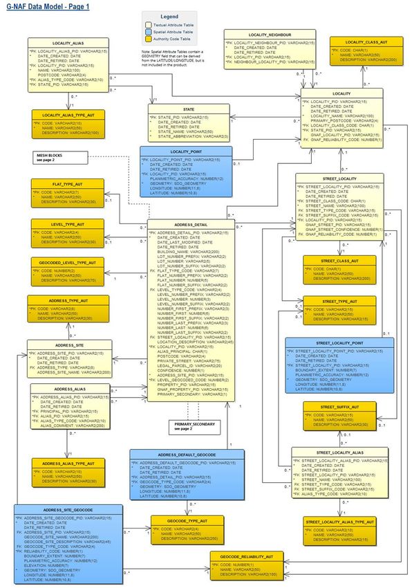
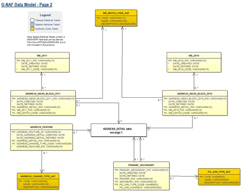
G-NAF Data Product Description Page 114. Data Content and Structure G-NAF is a feature-based product. A data model is included (Appendix B) with an associated data dictionary (Appendix C). 4.1 Feature-based data Data types and codes are derived from the address standard where applicable. However, in some cases, the codes have been extended to handle exceptional cases. The data model is hierarchical, storing information about streets and localities separate from address sites. Alias addresses are stored in the same way as principal addresses. There is simply a ‘mapping’ table provided to determine which address is an alias of which principal address. 4.2 Feature-based application schema (data model) The G-NAF data model is set out in Appendix B. 4.3 Data dictionary The G-NAF feature catalogue in support of the application schema is provided in Appendix C. Spatial attributes are added to the feature catalogue in the same manner as other attributes for completeness and conformance to the application schema. 4.4 Feature-based content scope All geometry and metadata for points within G-NAF. G-NAF Data Product Description Page 12
5. Reference System
5.1 Spatial reference system
GDA 94 or GDA 2020

5.2 Temporal reference system
Gregorian calendar

5.3 Reference system scope
The spatial objects and temporal collection periods for G-NAF.

G-NAF Data Product Description                                   Page 13
6. Data Quality
6.1 Positional accuracy
G-NAF is a concerted effort to deliver the best possible geocoded national address dataset
for Australia. The magnitude of this dataset, the complexity of its content, and the
multiplicity of its sources, means that there is ongoing requirement to improve the content,
quality and coverage of G-NAF.
All addresses in G-NAF contain a locality geocode. This geocode will generally be at the
centre of the locality.
If the name of the street in the address can be matched to one in the locality, then another
geocode is added at the centre of the street within that locality. This is generally referred
to as the street locality geocode.
If the address is provided with coordinates or can be matched to one that already exists,
then a third geocode will be added, placing the address inside the relevant property. This is
generally referred to as the address site geocode.

6.2 Coordinates Referencing the GDA 2020 Datum
From the November 2019 publication, coordinates in G-NAF are available referencing the
GDA 2020 datum. These coordinates are produced using a coordinate transformation from
GDA 94 using the following parameters.

shift_x = 0.06155,
shift_y = -0.01087,
shift_z = -0.04019,
rotate_x = -0.0394924,
rotate_y = -0.0327221,
rotate_z = -0.0328979,
scale_adjust = -0.009994

6.3 Attribute accuracy
Attribute accuracy is determined from rigorous standardisation processes and matching of
the contributor datasets together with matching of addresses against the gazetted localities
from Geoscape’s Administrative Boundaries and the roads layer of Geoscape’s Transport &
Topography dataset.

Address mesh block integration
G-NAF has a mesh block ID allocated to every address, where available. This includes
addresses that have a geocode allocated at a street-locality and locality level where a
single mesh block cannot be identified. A coding table (MB_MATCH_CODE_AUT) lists the
codes describing the level of matching to mesh blocks.
The ABS recommends that G-NAF addresses associated with locality (and street) level
geocode locations be associated with SA2 level units (ASGS units built up from SA2’s).
While there is a strong alignment between gazetted suburb and locality boundaries, there
are situations where SA2 boundaries split localities. In these circumstances, an unknown

G-NAF Data Product Description                                                        Page 14
proportion of the addresses associated with the locality centroid will be coded to an
incorrect SA2.

Allocation of postcodes
Postcodes are included in G-NAF at the address record level (i.e. postcode field in the
respective ADDRESS_DETAIL tables). Geoscape allocates a postcode to every address and
is based on the gazetted suburb/locality. The inclusion of a postcode in G -NAF is primarily
based on the most commonly used postcode for all the addresses within in each gazetted
suburb/locality. One of the exceptions is the addresses located in the area allocated to
postcode 3004 for St Kilda Road, where the majority of addresses would be in the suburb
of MELBOURNE.
Postcodes are used by Australia Post to facilitate the efficient processing and delivery of
mail. There is no mandatory requirement for inclusion of a postcode in an address
(AS4590).

6.4 Logical consistency
The dataset data structure has been tested for conformance with the data m odel.

6.5 Completeness
Completeness is an assessment of the extent and range of the dataset with regard to the
completeness of coverage, completeness of classification and completeness of verification.
The Data Maintenance section provides more information about the completeness of the
dataset based on the processing steps.

Dataset coverage
National

Features

Addresses included
G-NAF aims to include all physical addresses in circulation by using multiple sources. The
physical addresses in G-NAF are used to label land parcels and properties as well as for
locating assets such as ATMs, tree plantations, reserves and substations.

Attribute completeness
All mandatory attributes for each object are populated. Some attributes are not populated
but have been included in the data model to assist with the alignment with relevant
standards.
The process of collating addresses varies across the contributors supplying data to G -NAF.
Therefore, the attributes supplied can vary, but Geoscape will attempt to populate
attributes based on the available information from the contributors.

Quality scope
The attribute accuracy is in scope for all areas in G-NAF.

G-NAF Data Product Description                                                          Page 15
7. Data Capture
Data is contributed to G-NAF by organisations including the mapping agencies and land
registries of each of the state and territory governments, and Commonwealth government
agencies.

7.1 Data capture scope
Data for changed objects within the current release period.

G-NAF Data Product Description                                                   Page 16
8. Data Maintenance
Maintenance activities are triggered by Geoscape receiving updated address data from data
contributors according to an agreed delivery schedule. At present, this schedule defines a
quarterly update process.
During the maintenance phase, contributed addresses are analysed and compared to
existing records in G-NAF. This analysis and comparison give rise to new records being
inserted and existing records being updated or retired.
The following diagram of the G-NAF Maintenance Process provides a high-level view of the
G-NAF system including G-NAF maintenance pre-processing, the use of reference data files,
G-NAF maintenance software and G-NAF outputs.

                                 Reference                             Contributor
                                  Reference                             Contributor
                                   Reference
                                 Data Files                              Contributor
                                                                        Data Files
                                  Data Files                             Data Files
                                   Data Files                             Data Files

                                                     G-NAF
                                                  Maintenance                   Rule Generation
                                                 Pre-Processing

                                                     G-NAF
                                                  Maintenance                          Log Files
                                                Software – see below

                                                    PSMA
                                         Geocoded National Address File
                                                   (G-NAF)
                                                  Database

                        Reports                  Data Extraction
                                                                                          G-NAF
                                                                                           Data

G-NAF Data Product Description                                                                     Page 17
8.1 Pre-processing
The G-NAF maintenance pre-process takes the input files from the Geoscape reference
datasets and contributor data and performs processing prior to data being processed by the
G-NAF maintenance software.
Pre-processing is used to describe the following activities:
• Mapping from the contributor model to G-NAF model (with parsing as necessary)
• Application of rules that make corrections to misspellings, abbreviations and
erroneous characters
• Application of updates to suburb data and road names propagating the changes
through all affected parts of the data.
Data structure of an address
For an address to be included in G-NAF, it must be a “complete” entry. Complete equals:
• Must include a matched locality
• Must include a street name
• Must contain either a valid number_first or a lot number.
Reference datasets
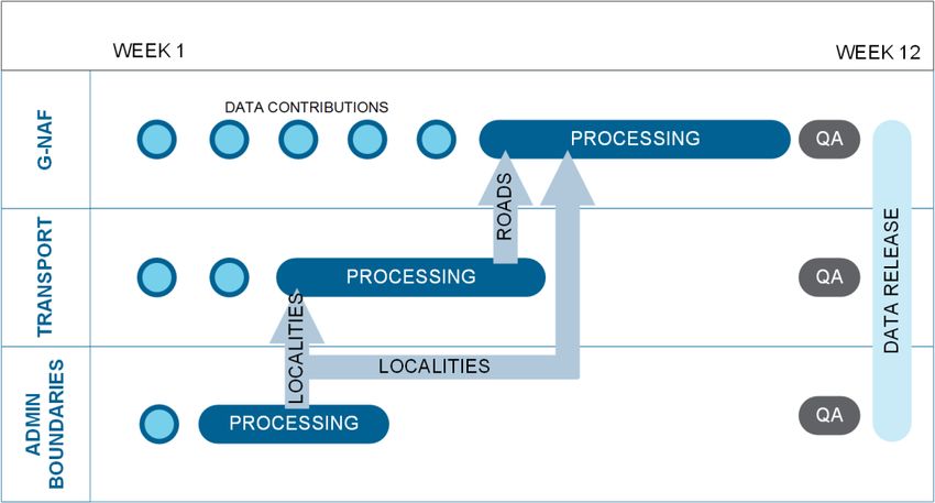
G-NAF is a dataset which is reliant on other Geoscape datasets. Below is a diagram which
displays that relationship and order of production cycle for the release of Geoscape
datasets. Geoscape’s Administrative Boundaries and Geoscape’s Transport & Topography
datasets need to be completed before G-NAF production can commence.
8.2 G-NAF maintenance software
The G-NAF maintenance software receives data from the pre-processing phase. All the
contributed addresses from each jurisdiction are cleansed, compared and merged into the
normalised G-NAF maintenance model.
Processing
The core maintenance processing consists of the following:
• Address scrubbing
G-NAF Data Product Description Page 18• State-Locality validation and geocoding
• Street validation
• Street geocoding
• Address geocoding
• Merging (merge criteria and confidence levels)
A further series of processing occurs for the following steps:
• Post merge processing (including validation processes)
• Primary / Secondary maintenance
• Alias / Principal maintenance
• Geocode maintenance
• Update address attributes (update attributes not in core processing)
• Update address links (i.e. contributor mapping, mesh blocks, default geocode)
• Verify G-NAF data (i.e. conformance with a data model)
• Data export to integrated maintenance database.
Geocoding
Multiple geocodes and multiple types of geocodes can be stored for each address. While
this capability exists in the G-NAF model, addresses with multiple geocodes only exist for
some addresses at this stage.
Geocode level type
Every address within G-NAF must have a locality level geocode, it may also have a street
level geocode and a parcel level geocode. The table GEOCODE_LEVEL_TYPE_AUT indicates
which of these geocode level types are associated with an address in accordance with the
table below:
Geocode_Level_Type Description
0 No Geocode
1 Parcel Level Geocode Only (No Locality or Street Level Geocode)
2 Street Level Geocode Only (No Locality or Parcel Level Geocode)
3 Street and Parcel Level Geocodes (No Locality Geocode)
4 Locality Level Geocode Only (No Street or Parcel Level Geocode)
5 Locality and Parcel level Geocodes (No Street Level Geocode)
6 Locality and Street Level Geocodes (No Parcel Level Geocodes)
7 Locality, Street and Parcel Level Geocodes
Note: LEVEL_GEOCODED_CODE field within the ADDRESS_DETAIL table refers to the
CODE field within the GEOCODE_LEVEL_TYPE_AUT.
Geocode reliability
Reliability of a geocode refers to the geocode precision and is linked to how the geocode
was generated. Every geocode in G-NAF has a reliability level. The levels and their
descriptions are stored in the table GEOCODE_RELIABILITY_AUT. These descriptions
together with examples are given in the table below.
Reliability Description Example
Level
1 Geocode resolution recorded to appropriate Address level geocode was manually geocoded with a
surveying standard GPS
2 Geocode resolution sufficient to place Address level geocode was calculated as the geometric
geocode within address site boundary or centre within the associated cadastral parcel
access point close to address site boundary Geocode for access point identified for a rural property
G-NAF Data Product Description Page 19Reliability Description Example
Level
Calculated geocode based on centre setback from road
within cadastral parcel
Geocode for approximate centre of building
3 Geocode resolution sufficient to place Address level geocode was automatically calculated by
geocode near (or possibly within) address site determining where on the road the address was likely to
boundary appear, based on other bounding geocoded addresses
4 Geocode resolution sufficient to associate Street level geocode automatically calculated by using the
address site with a unique road feature road centreline reference data
5 Geocode resolution sufficient to associate Locality level geocode automatically calculated to the
address site with a unique locality or geometric centre within the gazetted locality for this
neighbourhood address
6 Geocode resolution sufficient to associate Locality level geocode derived from topographic feature
address site with a unique region
Note: RELIABILITY_CODE field within the ADDRESS_SITE_GEOCODE table refers to the
CODE field within the GEOCODE_TYPE_AUT.
Every geocode has a reliability level. These levels are stored with the geocodes in the
following tables:
• LOCALITY_POINT
• STREET_LOCALITY_POINT
• ADDRESS_SITE_GEOCODE
Geocode type
Provision has also been made for G-NAF to cater for multiple types of geocodes for an
address. Where geocode types are nominated by the jurisdiction, these are reflected in the
geocode type field. Where a geocode type is not provided, a default value is used that
reflects the majority of addresses. Nationally, the PROPERTY CENTROID (PC) geocode type
is the most uniform. While the data model and respective geocode types have been listed,
in the vast majority of cases, there are no current national data sources identified to
populate the additional codes. The full list of allowed geocode types is included of the Data
Dictionary in Appendix C (i.e. GEOCODE_TYPE_AUT table).
90B Geocode priority
A priority order has been developed and applied during G-NAF production to provide a
single geocode for all G-NAF addresses. The priority order developed places emphasis on
identifying locations associated with emergency management access, buildings on a site
and other locations which are associated with the land management process. This order
has been developed to assist users in general and will not be suitable for all user business
needs. The priority order applied is included in the relevant table in Appendix C. The
priority order has been applied in the ADDRESS_DEFAULT_GEOCODE table.
Confidence levels
Every address and geocode can be related to a supplied dataset, which in turn can be
related to the contributor who provided it. This feature is essential to being able to supply
the information back to the address contributors. However, the address custodian identifier
is not available in G-NAF. Instead, address level metadata is available indicating how many
source datasets provided each address.
Address Usage is reflected in the Confidence field included in the ADDRESS_DETAIL table
and is expressed as follows:
n–1=C
(n = number of datasets providing the address, C = confidence level)
G-NAF Data Product Description Page 20Given G-NAF has been built with three contributor datasets, the Address Usage (Confidence
Level) possibilities are as follows:
Confidence Level Description
Confidence level = 2 This reflects that all three contributors have supplied an identical address.
Confidence level = 1 This reflects that a match has been achieved between only two contributors.
Confidence level = 0 This reflects that a single contributor holds this address and no match has been
achieved with either or the other two contributors.
Confidence level = -1 This reflects that none of the contributors hold this address in their address dataset
anymore.
Where an address is no longer provided by any contributor, the address will be retired. The
retirement will be reflected in its confidence level value of -1. Up until the August 2018
release of G-NAF all retired addresses were retained in G-NAF for four releases after which
they were then archived and not retained in the product. The introduction of the
ADDRESS_FEATURE table in August 2018 with the tracking of change to addresses,
requires the need to retain all retired addresses to show change over time.
Merge criteria
Addresses which share similar characteristics from the different contributors are merged
into a single record. These shared characteristics are known as the merge criteria.
The fields comprising the G-NAF merge criteria are:
• STATE_ABBREVIATION
• LOCALITY_NAME
• PRIMARY_POSTCODE
• STREET_NAME
• STREET_TYPE
• STREET_SUFFIX
• NUMBER_FIRST_PREFIX
• NUMBER_FIRST
• NUMBER_FIRST_SUFFIX
• NUMBER_LAST_PREFIX
• NUMBER_LAST
• NUMBER_LAST_SUFFIX
• FLAT_NUMBER_PREFIX
• FLAT_NUMBER
• FLAT_NUMBER_SUFFIX
• LEVEL_NUMBER
Note: Exception for Addresses without a number_first
When a contributed address is supplied without a number_first, consideration is given as to whether
the address contains a lot_number. An address without a number_first but with a lot_number will be
added to G NAF.
A G-NAF ID or address_detail_pid relates to a unique combination of these merge criteria
fields. This address_detail_pid will persist with the address while it remains in the dataset.
Where values in fields which are not included in the merge criteria (from the
ADDRESS_DETAIL table) change in consecutive product releases, the address_detail_pid
will not change. However, the associated date_last_modified field will.
G-NAF Data Product Description Page 21Merge criteria changes
When any element of the merge criteria changes, the new record is treated as a new
address and inserted into G-NAF as such.
Example
This example shows Unit 3 21 Smith Street Burwood (address_detail_pid =
GAVIC411711441) being changed to Unit 3 21 Brown Street Burwood by a contributor. The
street name change will mean it is no longer possible to match the new incoming record to
an existing G-NAF record, so a new G-NAF record (address_detail_pid = GAVIC998999843)
is created.
As the existing address (i.e. GAVIC411711441) is now only supported by two contributors,
its confidence level is reduced to 1. The new incoming address, only supported by one
contributor, will get a confidence of 0.
Existing G-NAF Record
GNAF_ FLAT FLAT BUILDING NUMB STREET STREET LOCALITY C DATE DATE DATE
PID _TYP _ _NAME ER _NAME _TYPE _NAME O _ _ _LAST
E NUM _FIRS N CREA RETIR _
BER T F TED ED MODI
I FIED
D
E
N
C
E
GAVIC41 UNIT 3 PONDEROSA 21 SMITH STREET BURWOOD 2 29/04/
1711441 2014
Updated G-NAF Records
GNAF_ FLAT FLAT BUILDING NUMB STREET STREET LOCALITY C DATE DATE DATE
PID _TYP _ _NAME ER _NAME _TYPE _NAME O _ _ _LAST
E NUM _FIRS N CREA RETIR _
BER T F TED ED MODI
I FIED
D
E
N
C
E
GAVIC41 UNIT 3 PONDEROSA 21 SMITH STREET BURWOOD 1 29/04/ 14/06/
1711441 * 2014 2014
GAVIC99 UNIT 3 PONDEROSA 21 BROWN STREET BURWOOD 0 14/06/
8999843 2014
Address duplication
As multiple contributors supply data nominally covering the same area, there is a
possibility that there are duplicate addresses which represent the same addressable
location. The above example simplistically demonstrates how this could occur. Geoscape
has developed a sophisticated series of production processes in an effort to counter these
issues. The majority of this duplication has occurred as a result of the following:
The use of both ranged and non-ranged addresses for the same site (e.g. 22-28 Sydney
Street vs 22 Sydney Street).
The use of a flat number as opposed to a number_first suffix for the same site (e.g. 2/27
Melbourne Street vs 27B Melbourne Street).
Where one contributor supplies a level number as part of an address string and another
contributor does not supply the level number for the same site. This tends to occur on
properties where “hotel style addressing” is used (e.g. Level 3, 302/50 Adelaide Street vs
302/50 Adelaide Street).
Where circumstances of this nature have been identified during processing, alias principal
relationships have been established to prevent the duplication of addresses.
G-NAF Data Product Description Page 22Alias Management
The usability of G-NAF is greatly enhanced by the inclusion of alias information that
captures addresses in popular use irrespective of official status. Geoscape recognises that
G-NAF has a role to play in progressing usage of official gazetted addresses. However, it is
also acknowledged that the issue cannot be forced and in some cases, it will take
generational change to see alias or incorrect addresses taken out of everyday usage.
It is also considered that the benefits of the inclusion of aliases outweigh the costs;
particularly in the application of G-NAF by emergency services. There are three levels of
aliases in the G-NAF schema:
• Alias Address - where an individual address is also known by another name
• Alias Street/Locality Address - where a street/locality pair does not exist in the
reference data and is the synonym or incorrect spelling of a street/locality pair
that does exist.
• Alias Locality Address - where a locality does not exist in the reference data and
is the synonym or incorrect spelling of a locality that does exist
Alias address
Alias addresses (ADDRESS_ALIAS) are addresses, other than the principal address, that
refer to the same physical location as another address record.
An address level alias refers to the same address site which is identified by d ifferent
address elements.
The relationship between addresses at a specific site is modelled through a principal and
alias attribute and join table.
Alias street/locality
Alias street/locality (STREET_LOCALITY_ALIAS) is used to determine addresses that refer
to the same physical location as another address record, where the street/locality is
different. Where it is identified that the street/locality in an address from a contributor was
incorrect (e.g. spelling error), a rule (see below) is created to manipulate the data during
the scrubbing process.
Alias locality
Alias localities (LOCALITY_ALIAS) are used to determine those addresses that refer to the
same physical location as another address record, but where the locality is different.
The example locality ‘"CITY” will exist in the LOCALITY table and an entry for “CANBERRA
CITY”’ will exist in the LOCALITY_ALIAS table.
G-NAF Data Product Description Page 23Using alias datasets
When using G-NAF to validate an address, the steps are:
1. Is there a principal address for this address?
2. Is there an alias address for this address?
3. Is there an alias locality for the locality of the address?
This can be determined by checking the locality name of the address against
the LOCALITY_NAME field in the LOCALITY_ALIAS table; the locality_pid is
then used to determine the correct locality_name from the LOCALITY table.
The next step would be to retry steps 1 & 2 with the new locality_name.
4. Is there an alias street/locality for the address?
This can be determined by checking the street name of the address against
the street_name, street_type, street_suffix fields in the
STREET_LOCALITY_ALIAS table; the street_pid is then used to determine the
correct street_name from the STREET table. The next step would be to retry
steps 1, 2 & 3 with the new street name.
Processing links to other Geoscape Data
Administrative Boundaries
There are three layers within the Administrative Boundaries product that have linkages to
G-NAF:
1. Suburbs/Localities
2. Mesh Blocks 2011 (ABS Boundaries 2011 theme).
3. Mesh Blocks 2016 (ABS Boundaries 2016 theme).
Suburbs/Localities is a reference dataset for G-NAF and is the source for identifying the
official locality name for an address, where available. The suburbs/localities geometry is
also an important part in the allocation of geocodes for locality and street -locality geocodes
generated for G-NAF.
Transport & Topography
The Roads layer within Transport & Topography is a reference dataset that it used is for the
processing of G-NAF. The roads data is a fundamental part of an address and is used as the
source for the allocation of road names in the STREET_LOCALITY table. The ro ads
geometry is also used in the allocation of the street-locality level geocodes. Other
Transport & Topography layers have no linkage to G-NAF.
Legal Parcel Identifier
The ADDRESS_DETAIL table contains a field called LEGAL_PARCEL_ID, the process involves
incorporating the cadastral information captured from the address supplied by the
jurisdiction, where possible. This process is done at the time that the address data is
supplied by the jurisdiction and more accurately represents the cadastral information used
for an address by the jurisdiction. Addresses from other contributors will also be allocated
the same cadastral information where the geocode is at the same location. The
LEGAL_PARCEL_ID field is populated with the cadastral information using the sam e
concatenations (where applicable) as adopted for the JURISDICTION_ID used in the
Cadastre theme (CAD table) of the CadLite product as shown in the table below.
State Concatenation
ACT DIST + “/” + DIV + “/” + SECTION + “/” + BLOCK + “/” + UNIT
ID
G-NAF Data Product Description Page 24State Concatenation
NSW LOTNUMBER + “/” + SECTIONNUM + “/” + PLANLABEL
CADID
NT PAR_LOC + “/” + PAR_LTO + “/” + PAR_PAR + “/” + PAR_PT
PAR_LOC + “/” + PAR_LTO + “/” + PAR_PAR + “/” + PAR_PT + “/” + UNIT_NUM
OT PIPARCEL (applies to Christmas and Cocos Keeling Islands)
LOT_NUMBER + “/” + PIPARCEL (applies to Christmas and Cocos Keeling Islands)
DIST + “/” + DIV + “/” + SECTION + “/” + BLOCK (applies to Jervis Bay)
LOT + “/” + SECTION + “/” + PORTION (applies to Norfolk Island)
QLD LOT_NUM + “/” + PLAN_NUM
SEG_PAR
SA PLAN_T + PLAN + “/” + PARCEL_T + PARCEL
TAS LOT + “/” + PLAN
Val(mid$(UFI,4,20))
VIC LOT_NUMBER + “/” + PLAN_NO + “~” + ALLOTMENT + “/” + SEC + “/” + BLOCK + “/” + PORTION + “/” +
PARISHC
PFI
WA PIPARCEL
LOT_NUMBER + “/” + PIPARCEL
Jurisdiction Property Identifier
The ADDRESS_DETAIL table includes a field called GNAF_PROPERTY_PID that includes the
property identifier provided by the jurisdiction for the property associated with the address.
This identifier is the same as the JURISDICTION_ID in the Property theme (PROPERTY
table) of the Cadlite product as shown in the table below.
State Field Concatenation
ACT JURISDICTION_ID TITLE + “/” + UNIT
NSW JURISDICTION_ID PROPID
NT JURISDICTION_ID VOLUME_TYP + “/” + VOLUME_NO + “/” + FOLIO_NO
QLD JURISDICTION_ID PROPERTY_ID
SA JURISDICTION_ID ASSNO_TENSEQNO
TAS JURISDICTION_ID PID
VIC JURISDICTION_ID PFI
WA JURISDICTION_ID VPU_VE_NUMBER
8.3 Maintenance scope
Data for existing objects with changed geometry and attributes as well as data for new
objects within the release period are included in the release.
G-NAF Data Product Description Page 259. Data Product Delivery Geoscape Australia is the crucial link between the supply and demand sides of the market for the fundamental national spatial datasets that it offers under the banner of Geoscape Data. The organisation eliminates the difficulties of negotiating multiple license agreements with Australian governments and the problems of integrating the data into a seamless consistent national dataset. Furthermore, the existence of Geoscape Australia minimises the duplication of effort within the market for organisations wishing to access national data. Access to Geoscape Data is enabled through multiple methods including a network of product partners who are licensed by, and work closely with Geoscape Distribution, the wholly owned subsidiary of Geoscape Australia. Product partners create many powerful and varied applications that use Geoscape Data. Geoscape Distribution provides strategic support to partners to ensure that both the public and private sectors obtain the maximum benefit from the use of Geoscape Data. Geoscape Australia’s website www.geoscape.com.au provides a partner directory to assist those interested in accessing Geoscape Data. Current users of Geoscape Data should contact their partner for clarification or guidance before contacting Geoscape Distribution. For further information on accessing Geoscape Data, or becoming a Product Partner contact: Geoscape Distribution Unit 6, 113 Canberra Avenue, Griffith ACT 2603 T: 02 6260 9000 E: sales@geoscape.com.au W: www.geoscape.com.au 9.1 Delivery medium information Geoscape Australia provides data updates to licensees through data downloads via a distribution services available via https://geoscape.app/ 9.2 Units of delivery Datasets as prescribed in the license agreement brokered by Geoscape Distribution. 9.3 Medium name Online. 9.4 Delivery format information MapInfo Format Name: TAB – MapInfo Professional™ G-NAF Data Product Description Page 26
Specification:
The MapInfo TAB format is a popular geospatial vector data format for geographic
information systems software. It is developed and regulated by MapInfo as a proprietary
format. This format includes files with the following extensions: *.tab, *.dat, *.id, *.map
TAB files support geospatial standards such as Open GIS, the OGC, ISO, W3C and others.

Language:
English

Shape

Format Name:
Shape – ESRI™

Specification:
This format includes files with the following extensions: *.shp, *.shx, *.dbf
ESRI Shapefile Technical Description, an ESRI White Paper, July 1998
Follow this link: www.esri.com/library/whitepapers/pdfs/shapefile.pdf

Language:
English

Oracle Data Pump

104B   Format Name:
Oracle 11g Data Pump Format

105B   Specification:
 The Data Pump (dump) file set is made up of one or more files that contain table data,
106B

database object metadata, and control information. More information is available from
 Oracle
12TU         U12T

107B   Language:
English

G-NAF Data Product Description                                                         Page 27
10. Geoscape Data
 DATASET          ACCESS              THEME                           LAYER
 Administrative   Open Data           ABS Boundaries 2011             2011 ABS Mesh Blocks
 Boundaries       (www.data.gov.au)
                                                                      Indigenous Location (ILOC)
                  Partner Network
                                                                      Indigenous Areas (IARE)
                                                                      Indigenous Region (IREG)
                                                                      Remoteness Areas (RA)
                                                                      Socio-Economic Indexes for Areas (SEIFA)
                                                                      Urban Centre Localities /Section of State

                                                                      Significant Urban Areas (SUA)
                                      ABS Boundaries 2016             2016 ABS Mesh Blocks and Statistical Areas
                                                                      2016 ABS Indigenous Regions, Areas and
                                                                      Locations
                                                                      2016 Urban Centre and Locality - Section of
                                                                      State - Significant Urban Area
                                                                      2016 Remoteness Areas (RA)
                                                                      2016 Socio-Economic Indexes for Areas (SEIFA)
                                      Electoral Boundaries            Commonwealth Electoral Boundaries
                                                                      State Electoral Boundaries
                                      Local Government Areas (LGAs)
                                      Suburbs/Localities
                                      State Boundaries
                                      Town Points

                                      Wards

 CadLite          Partner Network     Cadastre
                                      Property
 Geoscape         Partner Network     Buildings

                                      Surface Cover                   2 Metres

                                                                      30 Metres
                                      Trees

 G-NAF            Open Data           Geocoded physical addresses
                  (www.data.gov.au)
                  Partner Network
 Land Tenure      Partner Network     Land Tenure

 Features of      Partner Network     Features of Interest
 Interest

 Postcodes        Partner Network     Postcode Boundaries

 Transport &      Partner Network     Transport                       Roads
 Topography
                                                                      Rail
                                                                      Rail Stations
                                                                      Airports
                                      Hydrology
                                      Greenspace

G-NAF Data Product Description                                                                             Page 28
Appendix A – Addressing standards and
NAMF relationship
The field names used for G-NAF differ from those used by the address standard
AS4590:2006 and the National Address Management Framework (NAMF). Geoscape
recommends applying the following G-NAF fields to provide the relationship to AS4590 and
NAMF fields.
Table 1: Relationship between G NAF, AS4590 and NAMF fields
NAMF Field AS4590 Field G-NAF Field(s) Description
complexLevelType COMPLEX.LEVEL TYPE LEVEL_TYPE_AUT.DESCRIPTION Full name of level type
CODE
complexLevelNum COMPLEX.LEVEL ADDRESS_DETAIL.LEVEL_NUMBE Level number is a
ber NUMBER R_PREFIX, concatenation of the three
ADDRESS_DETAIL.LEVEL_NUMBE fields
R,
ADDRESS_DETAIL.LEVEL_NUMBE
R_SUFFIX
complexUnitType COMPLEX.SUB FLAT_TYPE_AUT.DESCRIPTION Full name of flat type
DWELLING UNIT TYPE
CODE
complexUnitIdentifi COMPLEX.SUB ADDRESS_DETAIL.FLAT_NUMBER Flat number is a concatenation
er DWELLING UNIT NUMBER _PREFIX, of the three fields
ADDRESS_DETAIL.FLAT_NUMBER
,
ADDRESS_DETAIL.FLAT_NUMBER
_SUFFIX
complexStreetNum COMPLEX.COMPLEX ADDRESS_DETAIL.NUMBER_FIRS Applicable if, and only if, a
ber1 ROAD NUMBER 1 T_PREFIX, primary secondary relationship
ADDRESS_DETAIL.NUMBER_FIRS is identified in G-NAF. The first
T, street number of the
ADDRESS_DETAIL.NUMBER_FIRS secondary address is a
T_SUFFIX concatenation of the three
fields
complexStreetNum COMPLEX.COMPLEX ADDRESS_DETAIL.NUMBER_LAS Applicable if, and only if, a
ber2 ROAD NUMBER 2 T_PREFIX, primary secondary relationship
ADDRESS_DETAIL.NUMBER_LAS is identified in G-NAF. The last
T, street number of the
ADDRESS_DETAIL.NUMBER_LAS secondary address is a
T_SUFFIX concatenation of the three
fields
complexStreetNam COMPLEX.COMPLEX STREET_LOCALITY.STREET_NAM Applicable if, and only if, a
e ROAD NAME E primary secondary relationship
is identified in G-NAF. Street
name of the secondary
address
complexStreetType COMPLEX.COMPLEX STREET_TYPE_AUT.DESCRIPTIO Applicable if, and only if, a
ROAD TYPE CODE N primary secondary relationship
is identified in G-NAF.
Abbreviation of street type of
the secondary address
complexStreetSuffi COMPLEX.COMPLEX STREET_SUFFIX_AUT.DESCRIPTI Applicable if, and only if, a
x ROAD SUFFIX CODE ON primary secondary relationship
is identified in G-NAF. Full
name of street suffix of the
secondary address
siteName ADDRESS SITE NAME ADDRESS_DETAIL.BUILDING_NA Building name. This may
ME require review, as there is also
a name in the
ADDRESS_SITE table.
Perhaps a business rule
similar to:
1 CASE
G-NAF Data Product Description Page 29NAMF Field AS4590 Field G-NAF Field(s) Description
2 WHEN
ADDRESS_DETAIL.BUILDIN
G_NAME IS NOT NULL THEN
ADDRESS_DETAIL.BUILDIN
G_NAME
3 ELSE
ADDRESS_SITE.ADDRESS_
SITE_NAME
4 END
lotIdentifier ROAD NUMBER.LOT ADDRESS_DETAIL.LOT_NUMBER Lot number is a concatenation
NUMBER _PREFIX, of the three fields
ADDRESS_DETAIL.LOT_NUMBER,
ADDRESS_DETAIL.LOT_NUMBER
_SUFFIX
streetNumber1 ROAD NUMBER.ROAD ADDRESS_DETAIL.NUMBER_FIRS The first street number is a
NUMBER 1 T_PREFIX, concatenation of the three
ADDRESS_DETAIL.NUMBER_FIRS fields
T,
ADDRESS_DETAIL.NUMBER_FIRS
T_SUFFIX
streetNumber2 ROAD NUMBER.ROAD ADDRESS_DETAIL.NUMBER_LAS The last street number is a
NUMBER 2 T_PREFIX, concatenation of the three
ADDRESS_DETAIL.NUMBER_LAS fields
T,
ADDRESS_DETAIL.NUMBER_LAS
T_SUFFIX
streetName ROAD.ROAD NAME STREET_LOCALITY.STREET_NAM Street name
E
streetType ROAD.ROAD TYPE CODE STREET_TYPE_AUT.DESCRIPTIO Abbreviation of street type
N
streetSuffix ROAD.ROAD SUFFIX STREET_SUFFIX_AUT.DESCRIPTI Full name of street suffix
CODE ON
localityName LOCALITY NAME LOCALITY.LOCALITY_NAME Locality name
stateTerritory STATE OR TERRITORY STATE.STATE_ABBREVIATION State or territory abbreviation
CODE
geoNorthSouthCoo GEOCODE.GEOCODE ADDRESS_SITE_GEOCODE.LATIT Business rule:
rdinate LATITUDE UDE OR 1 CASE
STREET_LOCALITY_POINT.LATIT
UDE OR 2 WHEN
LOCALITY_POINT.LATITUDE ADDRESS_SITE_GEOCODE.
LATITUDE IS NOT NULL
THEN
ADDRESS_SITE_GEOCODE.
LATITUDE
3 WHEN
STREET_LOCALITY_POINT.L
ATITUDE IS NOT NULL THEN
STREET_LOCALITY_POINT.L
ATITUDE
4 ELSE
LOCALITY_POINT.LATITUDE
5 END
geoEastWestCoord GEOCODE.GEOCODE ADDRESS_SITE_GEOCODE.LONG Business rule:
inate LONGITUDE ITUDE OR 1 CASE
STREET_LOCALITY_POINT.LONGI
TUDE OR 2 WHEN
LOCALITY_POINT.LONGITUDE ADDRESS_SITE_GEOCODE.
LONGITUDE IS NOT NULL
THEN
ADDRESS_SITE_GEOCODE.
LONGITUDE
3 WHEN
STREET_LOCALITY_POINT.L
ONGITUDE IS NOT NULL
THEN
STREET_LOCALITY_POINT.L
ONGITUDE
G-NAF Data Product Description Page 30You can also read