DIGIPLAN - Digital plans and plan data in Germany - TARGETED ANALYSIS // - ESPON
←
→
Page content transcription
If your browser does not render page correctly, please read the page content below
TARGETED ANALYSIS //
DIGIPLAN – Digital plans and plan
data in Germany
Annex 6 of final report
Final report // June 2021
This Targeted analysis was conducted within the framework of the ESPON 2020 Cooperation
Programme, partly financed by the European Regional Development Fund.

The ESPON EGTC is the Single Beneficiary of the ESPON 2020 Cooperation Programme. The
Single Operation within the programme is implemented by the ESPON EGTC and co-financed by
the European Regional Development Fund, the EU Member States, the United Kingdom and the
Partner States, Iceland, Liechtenstein, Norway and Switzerland.

This deliverable does not necessarily reflect the opinions of members of the ESPON 2020
Monitoring Committee.

Coordination and Outreach
Christian Fertner, University of Copenhagen and Piera Petruzzi, ESPON EGTC

Authors
Swiss Federal Research Institute WSL (Switzerland): Anna Hersperger, Silvia Tobias, Corina
Wittenwiler

Cite as
ESPON DIGIPLAN (2021) DIGIPLAN – Digital plans and plan data in Germany. Annex 6 of final
delivery. https://www.espon.eu/digiplan

Advisory group
Stakeholders: Ole Pagh Schlegel and Bent Lindhardt Andersen, Danish Housing and Planning
Authority, DK | Hilde Johansen Bakken, Ministry of Local Government and Modernisation, NO |
Silvia Jost, Yves Maurer and Marc Pfister, Swiss Federal Office of Spatial Development, CH

ESPON EGTC: Piera Petruzzi (Senior Project Expert), György Alföldy (Financial expert)

Acknowledgements
We would like to thank the experts who participated in the interviews.

Information on ESPON and its projects can be found at www.espon.eu.
The website provides the possibility to download and examine the most recent documents
produced by finalised and ongoing ESPON projects.

ISBN: 978-2-919795-63-5

© ESPON, 2021
Published in June 2021

Graphic design by BGRAPHIC, Denmark

Printing, reproduction or quotation is authorised provided the source is acknowledged and a copy
is forwarded to the ESPON EGTC in Luxembourg.

Contact: info@espon.eu
TARGETED ANALYSIS //
DIGIPLAN – Digital plans and
plan data in Germany
Annex 6 of final report
Final report // June 2021

Disclaimer

This document is a final report.

The information contained herein is subject to change and does not
commit the ESPON EGTC and the countries participating in the
ESPON 2020 Cooperation Programme.

The final version of the report will be published as soon as approved.
TARGETED ANALYSIS // DIGIPLAN – Digital plans and plan data in Germany

Table of contents
Abbreviations ......................................................................................................................................7
Foreword by the research team .........................................................................................................8

1               Introduction and data ........................................................................................................9
1.1             The German planning system and the land use plan ................................................................ 10

2               Scope of digital plan data................................................................................................12
2.1             The current state of digital plan data ......................................................................................... 12
2.2             The historical background ......................................................................................................... 16
2.3             Standards ................................................................................................................................. 18

3               Organisation of digital plan data ....................................................................................20
3.1             Organisation.............................................................................................................................. 20
3.2             Financing .................................................................................................................................. 22
3.3             The role of different actors for ................................................................................................... 23
3.4             Relation within different levels of government ........................................................................... 24
3.5             Relation between governmental and not-governmental actors ................................................. 24

4               Use of digital plan data ....................................................................................................26
4.1             Use of digital plan data ............................................................................................................. 26
4.2             Digital plan data on different levels ........................................................................................... 26
4.3             Accessibility .............................................................................................................................. 26
4.4             Process changes ...................................................................................................................... 27
4.5             Purpose / added value .............................................................................................................. 29
4.6             Digital and analogue ................................................................................................................. 30
4.7             Challenges ................................................................................................................................ 30
4.8             Future use scenarios ................................................................................................................ 31

5               Synthesis and recommendations ...................................................................................33

References .........................................................................................................................................35

                                                                                                                                ESPON // espon.eu            5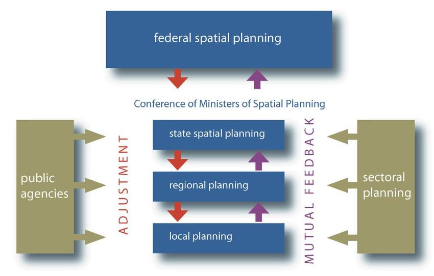
TARGETED ANALYSIS // DIGIPLAN – Digital plans and plan data in Germany

List of maps, figures, charts and tables
List of maps
Map 2.1        Status of current regional plans in Germany, France and Switzerland in the Upper
               Rhine Conference area ........................................................................................................ 16

List of figures
Figure 1.1       Administration of Germany .................................................................................................. 10
Figure 1.2       Planning system in Germany ............................................................................................... 11
Figure 2.1       Interface of the geodata-infrastructure Germany ................................................................. 12
Figure 2.2       Website MetaVer with the metadata of the binding land use plans of Hamburg .................. 13
Figure 2.3       Geoportal of Freiburg with the binding land use plans that are currently in force ................ 14
Figure 2.4       Preparatory land use plan in the geoportal of Freiburg ....................................................... 15
Figure 2.5       History of XPlanung ............................................................................................................. 17
Figure 3.1       Organisation of GeoRhena in the Upper Rhine Conference ................................................ 22
Figure 4.1       Enabling of digital process chains based on the standards of XPlanung and XBau ............ 28
Figure 4.2       Simplified flowchart for the preparation of a land-use plan in Stuttgart ................................ 29

List of tables
Table 1.1        Interviews held ...................................................................................................................... 9
Table 2.1        Standards in Germany regarding digital plan data .............................................................. 19

6   ESPON // espon.eu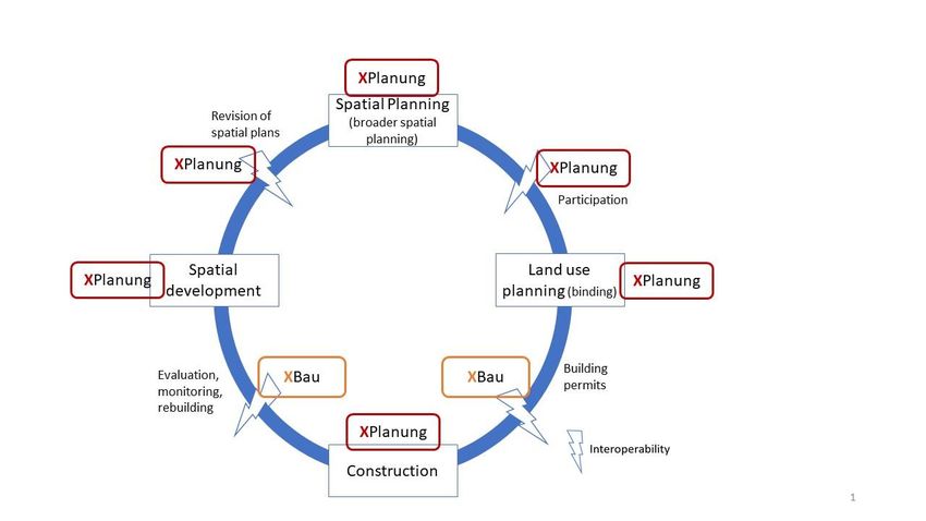
TARGETED ANALYSIS // DIGIPLAN – Digital plans and plan data in Germany

Abbreviations
GDI-DE        Geodateninfrastruktur Deutschland (Spatial Data Infrastructure Germany), project to make
              spatial data from different government levels available online.
INSPIRE       INfrastructure for SPatial InfoRmation in Europe, European directive
WFS           A standard protocol to share geographical features (e.g. polygons of plan areas) online
WMS           A standard protocol to share georeferenced map images (e.g. a scanned image of a plan)
              online.
XBau          A data standard and exchange format, supporting the communication of all actors in construc-
              tion permit and inspection.
XLeitstelle   X Coordination center, central secretariat for XPlanung and XBau
XPlanung      A data standard and exchange format, supporting a lossless transfer of spatial plans between
              different IT systems.

                                                                                        ESPON // espon.eu    7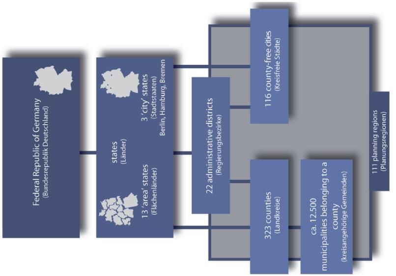
TARGETED ANALYSIS // DIGIPLAN – Digital plans and plan data in Germany

Foreword by the research team
In the DIGIPLAN project we explored the development and state of digital plans and plan data in several
European countries. It is the first of its kind; no similar research has been conducted before and the topic of
inquiry was spanning wide from the beginning. An explorative approach was necessary to shed light on more
or less advanced digital practices in different spatial planning contexts. However, we also present an early
systematisation of general concepts, key terms and approaches, describing emerging digital plans and plan
data and related practices. Although there is a huge diversity across the cases, they all have in common that
there are high ambitions and continuous development in the field of digital plans and plan data. Although a
targeted analysis for stakeholders from Denmark, Norway and Switzerland, DIGIPLAN findings can inspire
a wider professional audience.

This report is one out of six in-depth case studies, presenting findings from Germany. No German stake-
holder was connected to the DIGIPLAN project, but several interviews with practitioners from different levels
of governance provided insights into various aspects of digital planning practices. As with the other case
studies, we do not aim at giving a full picture of digitalisation of plans and plan data in Germany. This would
go far beyond the scope of DIGIPLAN. Instead, we provide insights from different places in the planning
system and in the country on current developments and challenges.

In Germany, as a federal country, the power of spatial planning is at state level which is a rather unfavourable
precondition for nationwide digital standards in spatial planning. A commendable attempt is made with the
exchange standard XPlanung which is presented in more detail in this report.

DIGIPLAN is a successful example of ESPON targeted analyses, a powerful mean to transfer knowledge,
share experience and facilitate the use of territorial evidence rooted in real place-based policy development
processes.

Enjoy reading!

    Anna Hersperger, Silvia Tobias, Corina Wittenwiler
    Swiss Federal Research Institute WSL

8      ESPON // espon.eu
TARGETED ANALYSIS // DIGIPLAN – Digital plans and plan data in Germany

1 Introduction and data
ESPON DIGIPLAN provides an overview on digitalization of plan data in 15 ESPON countries (Task 1),
insight information from case studies in 6 countries (Task 2) and several thematic papers, synthesizing the
state of the art in topics related to digital plan data and digital plans (Task 3). The general conceptual and
methodological framework is described in Annex 1 of the final delivery.

This Annex reports the case study on Germany, part of Task 2. The data collection in this case study is
based on the exploration of the various data portals and on expert interviews. The experts were identified
according to contact details on central portals and also according to the snowball principle where additional
experts were recommended by previous interview partners. In addition, several reports, websites and further
literature on the case study have also been included.

The focus of the German case study is on the one hand on the exchange standard XPlanung, considering
the national perspective of the X Coordination center, but also the municipal context using the example of
individual cities. On the other hand, a nationwide overview of the geodata infrastructure has been obtained.
This case study also examines the international cooperation of GeoRhena between the three countries,
Germany, Switzerland, and France. Information from interviews in the text is indicated by (DE01) to (DE05),
referring to an internal interview reference table. All interviews were conducted in German. Citations are own
translations based on transcription.

Table 1.1
Interviews held

 Theme                       Affiliation                      Position

                             XPlanung Coordination Of-
 XPlanung                    fice and municipal land use      Expert in Standard XPlanung and spatial planning
                             plan Hamburg

 Infrastructure, standards
                             GDI-DE                           Expert in geodata infrastructure and national view
 plan data

                                                              Expert in Standard XPlanung and spatial planning in the
                             XPlanung City of Stuttgart
 XPlanung, Municipal                                          City of Stuttgart
 land use plan                                                Two experts in Standard XPlanung and spatial planning
                             City of Freiburg
                                                              in the City of Freiburg

 Planning across borders     GeoRhena                         Expert in geodata and international collaboration

                                                                                                 ESPON // espon.eu      9
TARGETED ANALYSIS // DIGIPLAN – Digital plans and plan data in Germany

1.1 The German planning system and the land use plan
Germany has four levels of administration: the Federal Government, States, counties and municipalities
(Figure 1.1). The principles of spatial planning are defined by the federal government in the Spatial Planning
Act. In addition, the federal government can define guiding principles for spatial development, which are not
binding.

Figure 1.1
Administration of Germany

Source: Map: Own representation based on GeoBasis-DE / BKG 2020; figure: (Pahl-Weber & Henckel, 2008)

The fundamental aspects of spatial planning in Germany are defined by the Federal Government as princi-
ples of spatial planning (Figure 1.2). The federal government can also produce guiding principles for spatial
development. The States and municipalities are responsible for implementing spatial planning, whereas the
States often also implement planning regions for planning at regional, i.e. intermediate political, level. The
States have a large freedom of action for spatial development plans (so-called state planning). However, a
strategic environmental assessment is intended as an orientation to regulate actions that have an impact on
spatial development. At a lower level, urban land-use planning for individual parcels takes place in the mu-
nicipalities, based on the legal basis provided by the federal Building Code (Baugesetzbuch). The objectives
of these plans are to be aligned and adapted to the objectives of higher-level spatial planning. In the context
of urban land-use planning, the local authority draws up a preparatory land use plan, which acts as a basis
for the subsequent binding land use plans. The binding land use plans are binding for the respective parcels.

10   ESPON // espon.eu
TARGETED ANALYSIS // DIGIPLAN – Digital plans and plan data in Germany

Figure 1.2
Planning system in Germany

Source: Pahl-Weber & Henckel (2008)

                                                                                     ESPON // espon.eu   11
TARGETED ANALYSIS // DIGIPLAN – Digital plans and plan data in Germany
2 Scope of digital plan data
2.1 The current state of digital plan data
Geodata infrastructure Germany (GDI-DE)
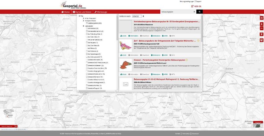
In the geoportal of the geodata infrastructure Germany (GDI-DE), geodata from the Federal Government,
the States and local authorities can be found and used (Figure 2.1). However, not all public geodata and
plan data are currently accessible, as there are sometimes problems with the naming of the data sets or the
metadata. There is still room for improvement. However, the aim of the GDI-DE is to make geodata more
accessible with this infrastructure. Therefore, the GDI-DE is currently being revised and next year the new
geoportal will be released (DE03).
Figure 2.1
Interface of the geodata-infrastructure Germany
Source: Binding land use plans (Bebauungspläne) and other digital plan data can be found with the search function
(geoportal.de)
Portal for Metadata MetaVer
In Germany, there is a data portal for metadata, called MetaVer1 (MetadatenVerbund) (Figure 2.2). The
following States participate in this: Brandenburg, Free Hanseatic City of Bremen, Free and Hanseatic City
of Hamburg, Mecklenburg-Western Pomerania, Saarland, Saxony and Saxony-Anhalt. This portal on
metadata contains general descriptive information on the data set, links to services provided or to other
geodata, information on spatial and temporal extent, information on availability and accessibility as well as
additional information.
1
https://metaver.de/portal/, access on 10.12.2020
12 ESPON // espon.euTARGETED ANALYSIS // DIGIPLAN – Digital plans and plan data in Germany
Figure 2.2
Website MetaVer with the metadata of the binding land use plans of Hamburg
Source: https://metaver.de/trefferanzeige?plugid=/ingrid-group:ige-iplug-hmdk.metaver&docuuid=EBA4BF12-3ED2-
4305-9B67-8E689FE8C445, accessed on 10 Dec 2020
National status of plan data
There are various ways of digitising binding land use plans in Germany. On the one hand, data sets can be
created directly in digital form, which is then available as a vector data set. These full vector data sets can
be used to analyse individual elements. On the other hand, full vectorial digitisation of analogue plans is
possible. In this case the individual elements of the analogue plans are captured as vectors. Thus, analyses
are also possible. The last possibility is the partial vectorial digitisation of analogue plans, where only the
perimeter of the plan is captured as vector and the scanned plan is linked to it. This guarantees the provision,
but no analysis can be made of the content of the plans (DE03). This method is also called raster-ring
scenario.
In Germany, the IT Planning Council 2017 decided that the responsible local authorities must be able to
handle the exchange standard XPlanung before 2022. This does not mean that all plan data must already
be available in this format, but that the local authorities are able to work with XPlanung. It is difficult to
determine the current status in this regard, as the expert from the X Coordination center (XLeitstelle) ex-
plained, since the States and local authorities do not have to report on their activities. Indeed, the States
pursue various strategies for implementing the exchange standard XPlanung, which the X Coordination cen-
tre does not have a complete overview of. The decision of the IT Planning Council from 2017 is binding, but
cannot currently be sanctioned. The steering committee of XPlanung, in which the States and the Federal
Government are represented, ensures mutual control. This setup allows the States to check what is going
on in the X Coordination center. and the X Coordination center can get some insights on how far the individ-
ual States have progressed with the implementation of XPlanung. As one interviewee states:
“It is difficult to assess the status today, as nobody is required to give an account to the XPla-
nung control centre.” (DE01)
At the national level the legal basis for spatial plan data throughout Germany are established with the Build-
ing Code (BauGB) and the Online Access Act (OZG). The Online Access Act created a legal basis for a
central portal for each State for spatial data. These portals must be implemented by 2023.
ESPON // espon.eu 13TARGETED ANALYSIS // DIGIPLAN – Digital plans and plan data in Germany
The INSPIRE Directive on the establishment of geodata infrastructures in Europe is also being implemented
in Germany. For this purpose, there is a monitoring system which checks the implementation in the individual
States and municipalities and shows the current status2.
Baden-Wurttemberg: Stuttgart and Freiburg
The state portal in Baden-Württemberg is currently in progress. About one third of the municipalities have
already agreed to make their binding land use plans available on the Internet via this portal. In Stuttgart, the
binding land use plans have so far been digitally available within the city administration as scanned and
georeferenced data. Publication via the Internet portal is planned. The legal texts concerning binding land
use plans are also available in digital form, but these are not linked to the geodata. However, this is conceiv-
able in the future. The expert from Stuttgart also noted the tendency for large cities to create their own data
and to produce land-use plans in the full vectorial XPlanung format rather than smaller cities and municipal-
ities, which tend more likely to the raster-ring method (DE02).
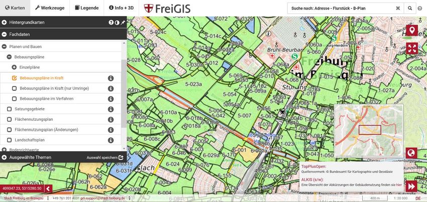
In the city of Freiburg im Breisgau in south-western Germany, binding land use plans are to be recorded in
full vectorial form. Since about 2010, all binding land use plans have been available in scanned form with
the perimeter as WMS and WFS service. The experts reported that of the approximately 750 existing binding
land use plans, 100 have already been completed in full vectorial digitisation (Figure 2.3). A further 50 bind-
ing land use plans are well advanced in full vectorial digitisation and another 50 are at the beginning of full
vectorial digitisation. While full vectorial digitisation is ongoing, there is currently an interruption in the pro-
cess due to personnel changes. In addition, it is always necessary to convince people and demonstrate the
added value in order to ensure continued funding. The binding land use plans will be ready by the time set
by the INSPIRE-obligation. In addition, the geoportal in Freiburg is currently being revised and updated.
Figure 2.3
Geoportal of Freiburg with the binding land use plans that are currently in force
Source: https://geoportal.freiburg.de/freigis/, accessed 10 Dec 2020
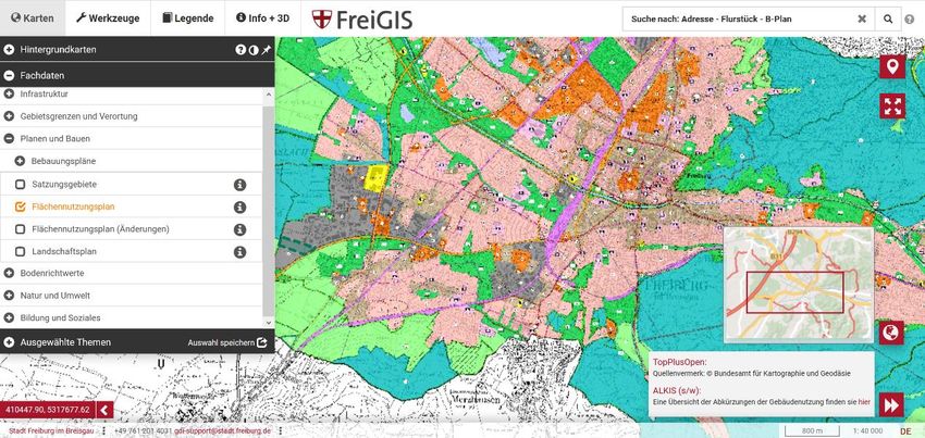
In Freiburg, the preparatory land use plan has been available in digital form internally for some time now.
However, this plan has only recently been published as a geo-referenced PDF file, and in a way that does
not allow to zoom in on a plot (addressed also in Chapter 4.3 Accessibility) (Figure 2.4). The plan itself is
2
https://www.gdi-de.org/INSPIRE/aktueller%20Stand, access on 10.12.2020
14 ESPON // espon.euTARGETED ANALYSIS // DIGIPLAN – Digital plans and plan data in Germany
not yet INSPIRE-compliant, except for the metadata. However, it will be INSPIRE-compliant after the next
revision (DE04).
Figure 2.4
Preparatory land use plan in the geoportal of Freiburg
This plan is shown in a georeferenced PDF-format, which makes it impossible to view the plan in a parcel-specific manner.
Source: https://geoportal.freiburg.de/freigis/, accessed 10 Dec 2020
GeoRhena international
GeoRhena was founded in 2004 with the aim of cross-border cooperation on various topics in the area
covered by the Upper Rhine Conference Germany, France and Switzerland. A geoportal has been available
since 2017, where cross-national geodata is published. The expert from GeoRhena mentioned that the IN-
SPIRE directive created pressure for the publication of metadata. Although the national guidelines and the
INSPIRE directive provide good guidelines for geodata, they are unfortunately not always implemented. For
this reason, for example in the context of nature conservation, it is estimated that only about 10% of geodata
from Germany, France and Switzerland are comparable. Also, in the spatial planning sector, the data sets
differ between the countries. This makes international evaluations in the Upper Rhine area with digital spatial
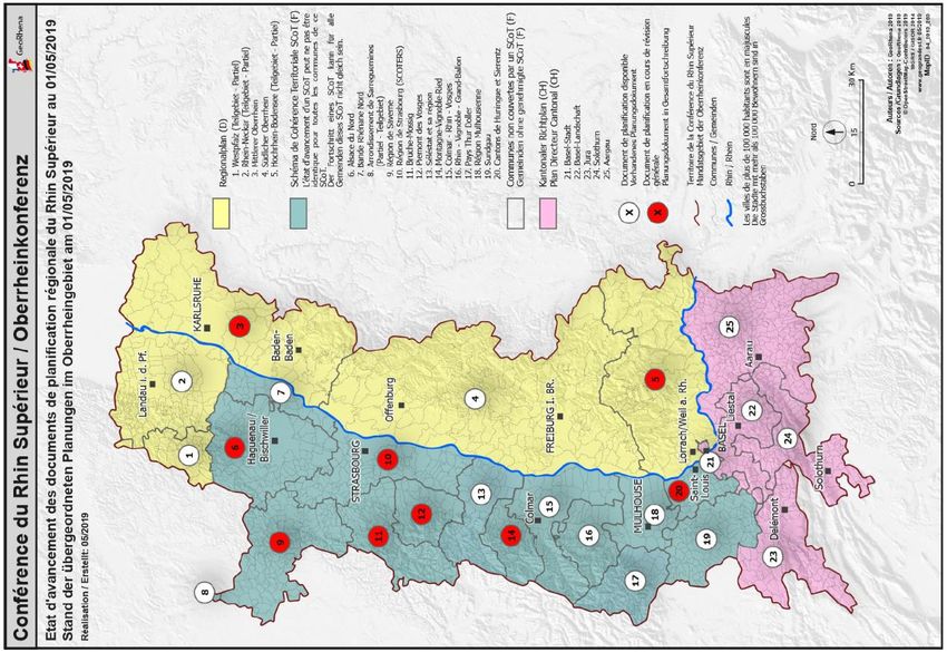
planning data difficult. However, GeoRhena has produced a plan on the current status of the regional plans
of the three countries, which is publicly available (Map 2.1). In general, GeoRhena produces maps and plans
on request. There are various work processes for this. For example, a working group from outside GeoRhena
asks for a particular map or evaluation and brings the relevant data for it. Alternatively, GeoRhena asks the
representatives of the respective countries whether the data is available. It should be noted, however, that
GeoRhena does not standardise or harmonise data, but only works with compatible data sets. It can happen
that requested maps and plans cannot be delivered by GeoRhena due to a lack of comparability of the data
sets or because of incompatible definitions in the three countries (DE05).
ESPON // espon.eu 15TARGETED ANALYSIS // DIGIPLAN – Digital plans and plan data in Germany Map 2.1 Status of current regional plans in Germany, France and Switzerland in the Upper Rhine Conference area Source: GeoRhena, https://sdi.georhena.eu/geonetwork/srv/ger/catalog.search#/metadata/d8f7f7b4-4f52-4b01-9c6e- c25ea6574d7f, accessed 10 Dec 2020 2.2 The historical background In 2005, the Geodata Infrastructure Germany (GDI-DE) was established as a collaborative project of the Federal Government, the States and the local authorities. The aim was to construct an infrastructure that would enable easier and better access to geodata on a broad range of topics. Working groups were set up to develop various topics and submit their proposals to the steering committee (Lenkungsgremium). Further- more, the INSPIRE Directive was introduced in 2007, which will provide a European infrastructure for re- searching, visualising and downloading data. The very experienced expert from XPlanung's coordination centre reported that in the 1960s and 1970s digitisation was considered a great opportunity by the planners. At that time financial resources were in- vested in urban development concepts. In the 1980s and 1990s money became scarce with the oil crisis. The authorities were also subject to criticism. Together with data protection concerns, this led to stopping 16 ESPON // espon.eu
TARGETED ANALYSIS // DIGIPLAN – Digital plans and plan data in Germany

previous developments. The era of perspective incrementalism began, where work was very project-ori-
ented. There were a few long-term monitoring issues and strategies during this period. Nowadays, however,
strategies and processes are again more in focus. The expert pointed out that the processing of digital plans
had been an important topic in teaching for a very long time. In practice, however, knowledge on digital plan
data was not demanded for a long time. These days, digitisation is slowly moving into practice and digital
data is increasingly used (DE01).

In the early 2000s, there were several e-government projects on standardisation in Germany (Figure 2.5).
At the federal level there was the Bund-Online project. Among others, the Deutschland-Online (D-Online)
project was launched, which intended to establish cooperative eGovernment between the Federal Govern-
ment, the States and local authorities. As part of this project, a survey was conducted in the municipalities
in the State of North Rhine-Westphalia on the subject of geodata (Figure 2.5). The expert from the X Coor-
dination Centre reported that the survey showed a great need for standardisation for the exchange of land-
use plans. The D-Online project consisted of several pillars, of which one was geodata and another con-
struction. The Federal Government, States and local authorities were then able to cooperate voluntarily on
specific topics in order to elaborate solutions. The City of Hamburg was also involved in this process. The
city and metropolitan region of Hamburg was thus quickly found as a partner for the standardisation project
within the project D-Online. This standardisation project was voluntary and did not include a budget. The
idea behind the voluntary cooperation was that participation would be worthwhile because of the added
value standardisation would create. The projects ran until about 2007 / 2008, when D-Online ended (Figure
2.5). As a result, the German Constitution was amended in 2010 (Art. 91c), enabling the Federal Government
and the States to develop IT standards. On this basis, the IT Planning Council was founded, which then
drafted a standardisation agenda. In 2012 / 2013, the IT Planning Council also defined the needs for stand-
ardisation (Standardisierungsbedarf). From 2008 to 2014, the standards were only promoted on a voluntary
basis and as part of support programmes (Figure 2.5). In 2017, the IT Planning Council then passed the
decision for the standards XPlanung and XBau (Figure 2.5). As a result of this binding decision, the local
authorities in Germany must be able to work with these standards at the latest in 2022.

Figure 2.5
History of XPlanung

Source: https://www.xleitstelle.de/leitstelle/historie, accessed 10 Dec 2020

In the city of Stuttgart, the entire plan archive was digitised for internal use in 2003 to simplify work processes
and archiving. The INSPIRE Directive then initiated the publication of the digital plan data in Stuttgart. How-
ever, Stuttgart has some legal problems with old land-use plans, as the focus in the post-war period was on
the reconstruction of the city and many land-use plans were created within a short time. Due to the fast
process many procedural errors occurred, which made these plans legally void. However, these plans have
a certain significance. Therefore, Stuttgart is now checking which of these land-use plans are still relevant

                                                                                              ESPON // espon.eu   17
TARGETED ANALYSIS // DIGIPLAN – Digital plans and plan data in Germany
and current. These and the newer land-use plans will then be published in future via a state-wide portal.
Digitisation in Stuttgart was generally fostered by the environmental law (LUBW (Landesanstalt für Umwelt
Baden-Württemberg)). Since digital data was needed in response to this law at an early stage, other data
was digitised within the authority over time. In addition, the city of Stuttgart initiated the Digital Move project.
This project aims at digitisation in the administration in order to standardise, automatise and efficiently design
internal administration processes and to aim for process high quality.
In the city of Freiburg, the digitisation of plan data began in the late 1990s and early 2000s. The first CAD
data to visualise plan content was available at the City Planning Office. The first data had not yet been
georeferenced, but this was gradually incorporated. In 2005, the establishment of a Geodata infrastructure
in Freiburg began, which made it possible to make digital data available both internally within administration
and externally. Thus, digital data became accessible with the infrastructure and the added value of digitisa-
tion could be captured. However, the digitisation of the land-use plans did take place later, starting in 2007.
The analogue plans were scanned, georeferenced and made available as a WMS service. It also became
clear that there is a need for a standardised presentation in compliance with planning law. Therefore, there
were thoughts about how the digitisation of the land-use plans could be carried out in a standardised manner.
In 2014 there was a further upswing in digitisation in Freiburg. The city won funding for an employee for the
full-vector digitisation of development plans. In addition, since 2015 new land-use plans have been produced
digitally and in full vectorial form. Although these plans are not yet fully compliant with XPlanung, the data
can be exported to XPlanung.
GeoRhena
The Upper Rhine Conference was founded after the Second World War for cross-border cooperation. At the
beginning, the participation of local authorities in this cooperation was very open and loose. The working
group on regional planning has existed almost since the beginning of the Upper Rhine Conference. The
working group led to the formation of GeoRhena in 2004.
2.3 Standards
In Germany, the need for standards came up in some instances before digitisation, but increased with the
digitisation of plan data. When planning offices and local authorities started to digitise plans in the 1990s,
digital plans were provided in a wide variety of data formats, which made it difficult to compare them. As a
result, the first ideas for a geodata infrastructure to store the data came up. Another entry point for the
development of standards has been the participation processes. Data for participation processes has been
digitised in the context of some funded projects. Thus, it was necessary to prepare the data for participative
interaction on the Internet, in a manner that follow-up work requires little effort. This in turn showed the need
for standardised digital plan data, as the X Coordination center expert described (DE01).
From the year 2004, interested parties could voluntarily participate in the exchange standard XPlanung as
part of the Germany Online (Deutschland-Online) project. Several large cities such as Hamburg, Berlin and
Stuttgart took part. In addition, medium-sized cities such as Oldenburg and various administrative counties
such as Elbe-Elster also participated. Furthermore, the Conference of Ministers for Spatial Planning (MKRO)
and the Federal Institute for Research on Building, Urban Affairs and Spatial Development (BBSR) as well
as the Association of German Cities, the German Association of Rural Counties and the German Association
of Towns and Municipalities participated. As one interviewee states:
“At the beginning, the implementation of the XPlanung standard was difficult in the municipali-
ties. [...] Although the programme was from the federal government, it was not binding. The
idea was to work together at eye-level, at federal, state and local level. What was developed
there would have such great added value that there was no need for any regulations on im-
plementation.” (DE01)
The INSPIRE Directive requires that digital data must be searchable, visualisable and downloadable. How-
ever, the implementation of INSPIRE in the States may vary slightly (addressed also in chapter 4.7 Chal-
lenges). There are similarities between the data models of INSPIRE and XPlanung. For this reason, the X
18 ESPON // espon.euTARGETED ANALYSIS // DIGIPLAN – Digital plans and plan data in Germany
Coordination center recommends that plan data be prepared in the XPlanung format. Using pre-configured
transformation rules in software, so-called presets, the plan data can then be transformed from XPlanung
format to INSPIRE. However, there are still obstacles, such as INSPIRE using an older version of GML than
XPlanung.
Table 2.1
Standards in Germany regarding digital plan data
Standards Standard for what? Portal
XPlanung Exchange of digital plan data Independent from portals
XML Metadata Geodata catalogue
WMS Visualisation of Geodata possible in many portals
WFS Possibility of downloading Geodata possible in many portals
Transformation regulation from XPlanung to INSPIRE
GeoRhena
GeoRhena itself does not harmonise data sets, but works with the lowest common denominator. For this
reason, the resolution of the data is often very rough, despite much effort. INSPIRE is mandatory for Ger-
many and France, but not for Switzerland. Nevertheless, Switzerland has taken INSPIRE's requirements
into account, with digital plan data being compatible. Yet, there are heterogeneous data with different defi-
nitions in the three countries. For example, the population density is calculated differently, with water surface
being subtracted in some cases. As a result, the data is not comparable. The expert noted that resources,
i.e., time and money, are often scarce in authorities GeoRhena works with. In addition, working processes
are defined by the countries, making additional data collection difficult. However, this could possibly change
in the future if more efforts were made to make plan data comparable. There is still a great need for action
(DE05).
ESPON // espon.eu 19TARGETED ANALYSIS // DIGIPLAN – Digital plans and plan data in Germany
3 Organisation of digital plan data
3.1 Organisation
Geodata infrastructure and XPlanung
The German geodata infrastructure (GDI-DE) includes a steering committee where the Federal Government
is represented by the Ministry of Economics and the Ministry of the Interior, the States themselves and the
local authorities by the three central associations (Spitzenverbände), the German Association of Cities, the
German Association of Counties and the German Association of Towns and Municipalities. This steering
committee makes collaborative decisions for the GDI-DE. The decisions lead to work assignments that are
then passed on to the coordination office (Koordinierungsstelle). This coordination office is not responsible
for the technical regulation of the data, but for the development of the geodata infrastructure and for the
coordination of the various authorities. The aim of the GDI is to ensure that the infrastructure can be used
everywhere and is also integrated into the European geodata infrastructure. In the current geoportal a wide
range of topics can be researched and displayed via a visualisation service. However, the data itself remains
with the data providers. A second version of the geoportal is currently being developed and will be introduced
in 2021. It should enable an improved search function. The search for geodata in the geoportal depends
essentially on the metadata and the labelling of the data sets. However, the metadata are not specified by
the GDI, but depend on technical specifications. In the case of spatial plan data, INSPIRE and XPlanung (X
Coordination center) are responsible for the technical specifications. The relevant regional authorities are
responsible for the implementation of technical specifications and standards. In the case of urban land use
planning, the municipalities are responsible for the implementation of XPlanung and INSPIRE standards.
This can be a challenge because the significance of such standards can vary considerably from municipality
to municipality. Neither the GDI-DE nor the X Coordination center is a supervisory organ that monitors the
implementation of XPlanung. The coordination office of the GDI-DE merely points out general problems in
the digitisation or provision of geodata. In addition, the coordination office shows the differences among
States in implementing the INSPIRE Directive. As the INSPIRE Directive has to be integrated into the legis-
lation of the individual States, there may be small differences among the States. For example, in some States
local authorities are only affected by INSPIRE if they are obliged under their own legislation to manage their
urban land use planning electronically. Since this is currently not the case, municipalities are not affected by
the INSPIRE Directive according to this interpretation. As one interviewee states:
“That is what a GDI is for: to have a data basis for weighing up these interests. And the EU
Directive INSPIRE is also intended to encourage the better consideration of environmental
aspects in decisions at all levels.” (DE03)
The GDI-DE itself does not develop software for the data processing of digital plan data, but rather supports
it with the specifications of the standards. However, good contact with software producers is very important.
For land-use plans, the coordination centre is responsible for this (DE03). The X Coordination center does
not develop software either, but is responsible for standard maintenance in the context of plan data (DE01).
Under the Online Access Act (OZG, 2003), there is to be a portal, at least state-wide, by the end of 2023,
where all information on spatial planning is integrated. This includes land-use plans, regional plans, prepar-
atory land use plans, regional planning procedures and declaratory procedures. This is the minimum goal in
Germany. However, no monitoring of the implementation of this law has been foreseen, as no contracting
authority has been appointed for this.
The X Coordination Centre was established in 2018 on the basis of a decision by the IT Planning Council.
This coordination centre for the standards XPlanung and XBau is responsible for the maintenance and fur-
ther development of these standards. There is no monitoring for the implementation of XPlanung, as is the
case with the OZG. The binding decision of the IT Planning Council itself is not a part of the German Building
Code. Therefore, there is no mandate for monitoring. Within the framework of the OZG there are various
digitisation laboratories, with Hamburg being highly involved. One digitisation laboratory is concerned with
the provision of spatial planning plans, another with participation procedures. In the latter case, a prototype
platform is planned, through which all spatially related participation processes can be carried out. A solution
20 ESPON // espon.euTARGETED ANALYSIS // DIGIPLAN – Digital plans and plan data in Germany
will be developed which can then be supplied to the States and local authorities on an open-sourced basis
(DE01).
The INSPIRE Directive has been transposed by the States into their own legislation. The States are thus
responsible for the subsequent implementation. There is an INSPIRE Monitoring 3 for the implementation of
the INSPIRE Directive4. With monitoring, attention can be drawn to general problems and appropriate actions
can be initiated (DE03).
In the full vectorial implementation of binding land use plans in XPlanung, the textual specifications are
assigned to the binding land use plan as a whole. In addition, the individual paragraphs are assigned to the
corresponding elements. Thus, specific analyses can be made. This basis can also be used in the future for
developing digital building permitting. The complete as well as specific representation of the textual defini-
tions in the system is redundant and thus the system could be improved (DE01).
GeoRhena
In the Upper Rhine Conference there are various working groups to support international cooperation in
Germany, France and Switzerland, among thers on spatial plannig (Figure 3.1, top left). GeoRhena is a
cross-border cooperation with representatives from Germany, France and Switzerland and part of the Upper
Rhine Conference’s working group on regional planning, although GeoRhena also deals with issues other
than regional planning (Figure 3.1, in blue). GeoRhena works on request, which means that maps, analyses
and plans are produced on certain topics when they are requested. For example, a map on the current status
of regional planning in the three countries was produced. If the current status is requested, this map is quickly
updated but the map is not updated at regular intervals, but only on request. A unified map of all regional
plans is not possible because of various incompatibilities (DE05, addressed also in chapter 4.7 Challenges).
3
https://www.gdi-de.org/INSPIRE/aktueller%20Stand, access on 10.12.2020
4
https://inspire-geoportal.ec.europa.eu/mr2019_details.html?country=de, access on 10.12.2020
ESPON // espon.eu 21TARGETED ANALYSIS // DIGIPLAN – Digital plans and plan data in Germany
Figure 3.1
Organisation of GeoRhena in the Upper Rhine Conference
Source: https://www.georhena.eu/de/Georhena_DE, accessed 10 Dec 2020
In principle, all data from GeoRhena is handled as open data and is made available as WMS or WFS, unless
it concerns sensitive subjects and information. The data is documented in German and French. GeoRhena
has also developed a declaration of intention to facilitate the mutual exchange of information on spatial
planning topics5.
3.2 Financing
The GDI-DE expert explained that the steering committee will be supported by the coordination office and is
jointly financed by the Federal Government and the States. The States contribute to the financing according
to a key that is based on the number of inhabitants and the area of the State. The XCoordination center is
also financed by the Federal Government and the States with 500,000 euros per year.
The X Coordination center expert noted that the States are responsible for the implementation of XPlanung
in the municipalities. They have different strategies on how to accomplish that. Often funding programmes
are used which support the digitisation of plan data or the municipalities receive support from the GDI of the
State. In Schleswig-Holstein, for example, infrastructure to make digital plans available is provided. However,
the digitisation and financing of the municipal plan data themselves is handled by the municipalities. In an-
other State, Lower Saxony, a programme called Plan Digital was initiated, where four million euros were
5
https://www.georhena.eu/sites/default/files/Cartes/08_2015_220.pdf, accessed 10 Dec 2020
22 ESPON // espon.euTARGETED ANALYSIS // DIGIPLAN – Digital plans and plan data in Germany
invested in the digitisation of the regional land use plans. As a further example, the expert referred to Ham-
burg, where within three years the 3000 zoning plans were digitised fully vectorially at a cost of 850,000
euros. During the transition phase in Germany, increased effort was expected in the correct application of
the software, e.g., to avoid overlaps in plans. For this implementation phase of XPlanung, the planning of-
fices were supported by the investor (mostly by the city) with 0 - 5% of the digitisation costs. The X Coordi-
nation center also cooperates with municipalities in part to enhance and provide open-source projects (WMS,
WFS) (DE01). As one interviewee states:
“Who finances the digitisation of plans currently being drawn up? There is always the ques-
tion of how much effort is required. [...] We assume that by now all plans are somehow digit-
ised/created with digital information systems, be it with CAD or GIS programmes. If the soft-
ware is used correctly, the effort is very low.” (DE01)
State development plans and regional planning in Germany are renewed approximately every 15 years and
are regularly financed by the States. Since technologies are expected to change anyway during this period,
the additional expenditure specifically caused by digitisation is estimated to be low (DE01).
The Stuttgart expert reported that the financing of municipal digitised plan data in the State of Baden-Würt-
temberg is handled by the municipalities themselves, as they are also responsible for planning at the mu-
nicipal level. In Baden-Württemberg, a state-wide portal for the provision of land-use plans is currently being
developed. There is support (e.g., through validators) for the municipalities which publish their plan data via
this portal. In general, the expert estimates that there are only a few municipalities which make the binding
land use plans available at a charge (DE02).
The former digitisation (scanning and georeferencing) of binding land use plans in the city of Freiburg was
supported by a funding programme. The funding was invested in personal costs. Although the digital pro-
duction of plan data is more costly than the analogue production, it produces high-quality data which allows
sophisticated analyses. At present, half of the binding land use plans are produced by the city of Freiburg
itself and about half by planning firms. The current financial expenses cover mainly the digitisation of the old
analogue land use plans. The provision of the urban land-use plans, road panorama data and the 3D data
is offered free of costs (DE04).
3.3 The role of different actors for
Digitisation
The establishment of a national portal for the provision of digital plan data is stipulated by the Online Access
Act. The application of the exchange standard XPlanung is defined by the decision of the IT Planning Coun-
cil. However, the X Coordination center has little influence on the implementation of this standard. The dig-
itisation of binding land use plans at the municipal level can, for example, be supported by funding pro-
grammes of the States (DE01).
Standardisation
The exchange standard XPlanung is implemented autonomously by the competent authorities. The X Coor-
dination center is responsible for maintaining the standard and can also support States or municipalities with
knowledge. However, to date there is no supervisory body that monitors the implementation of XPlanung
(DE01).
The INSPIRE Directive has been transposed by the States into their own laws, whereby differences may
arise, for example in the way local authorities are affected. The coordination office of the geodata infrastruc-
ture Germany (GDI-DE) has the task of showing the differences and coordinating the INSPIRE monitoring.
INSPIRE monitoring can also be used to take measures to improve comprehensive provision of digital plan
data, but also to improve cooperation between authorities. In addition, the coordinating office also identifies
general problems of data provision on the GDI-DE in an impact matrix (DE03).
ESPON // espon.eu 23TARGETED ANALYSIS // DIGIPLAN – Digital plans and plan data in Germany
Geodata infrastructure (GDI)
The geodata infrastructure Germany offers the possibility of providing digital plan data. The accessibility of
the data and whether access protection is provided for sensitive data depends on the service provider. There
is no nationwide procedure for this (DE03).
In the city of Freiburg, the urban planning office (Stadtplanungsamt) is responsible for the land-use plans
(preparatory land use plan and binding land use plans). In many cases, geodata infrastructures are only
created at the federal state and national level. However, in 2005 Freiburg voluntarily decided to create its
own GDI in order to subsequently save costs and make the current status of the data easily accessible.
Since Freiburg's urban county takes over the tasks of a municipality and a county, there are many stake-
holders involved who can benefit from the GDI (DE04).
3.4 Relation within different levels of government
The X Coordination center cooperates with the partners of the geodata infrastructure Germany (GDI-DE),
especially in terms of standards, data models and code lists. In this context, the X Coordination center de-
fines the content requirements and specifications for digital plan data, whereby the infrastructure is designed
to provide a wide range of data (DE03).
The expert from Hamburg said that the interaction within the authorities has been reduced as there is now
direct access to the binding land use plans via the Hamburg geoportal. The various users of the plan data
do not depend on the data providers or their contacts. When disturbances on the geoportal were still com-
mon, the authorities and users contacted the data providers in Hamburg. This indicated interest in the data
(DE01). As one interviewee states:
“We provide a lot of information on land use in the framework of INSPIRE. This is all digital
information. Due to the diversity of data provision, we are less frequently asked questions. So
whether you want to see this in a positive or negative perspective” (DE01).
The expert from Stuttgart did not observe any change in the relationship between the individual actors.
Although the activities of the authorities became more transparent due to the easier access to data, this
change had no direct influence on the individual actors (DE02).
GeoRhena
GeoRhena acts as a facilitator for international cooperation between Germany, France and Switzerland.
GeoRhena supports this process, for example, with a declaration of intent to promote the exchange of infor-
mation between these countries and also with plans showing the current status of regional planning. Inter-
national exchange can thus benefit. The GeoRhena expert also emphasised that the human aspect is im-
portant in cross-border cooperation. Thanks to the GeoRhena network, the experts from the three countries
know each other, which is why the barrier to cooperation is lower (DE04).
3.5 Relation between governmental and not-governmental actors
The Hamburg expert said that the criticism of intransparent preparation of plan data decreased due to digit-
isation and provision of plan data. In addition, the DIPAS (digital participation) project is currently being
implemented in Hamburg, where the population can be involved in the conception of land use plans. How-
ever, effects of digitisation on participation processes and on planning are difficult to determine. As one
interviewee states:
“There is little criticism that behind closed doors, some kind of planning concept is being de-
veloped which nobody would know about and which would not be transparently presented to
anyone. That is why no news is good news; if there are few complaints about a lack of partici-
pation, it can be seen as positive that participation opportunities are available.” (DE01)
24 ESPON // espon.euTARGETED ANALYSIS // DIGIPLAN – Digital plans and plan data in Germany
The expert from Stuttgart has also noted increased transparency through the digital publication of plan data.
Digital public hearings also make it easier to participate. However, participation in Stuttgart is not directly
dependent on digital means, but rather on the relevance of the project itself (DE02).
The GDI-DE works with municipalities indirectly via companies. Initially, cooperation was modest, as there
was not much demand for the XPlanung standard, but rather for the provision of data. In the meantime,
however, this has changed and companies advertise that they support standards (e.g., XPlanung) (DE03).
ESPON // espon.eu 25TARGETED ANALYSIS // DIGIPLAN – Digital plans and plan data in Germany
4 Use of digital plan data
4.1 Use of digital plan data
The expert from Hamburg said that the city offers digital plan data. However, little is known about the demand
for the plan data and the users of this data. Only when there are reports of malfunctions of the portal or
errors with data sets, does it become clear who is interested in these digital data. The way the data is used
is up to the users. However, there are possibilities to develop towards digital cities, where sensors could be
used as data sources for short-term and flexible development strategies. In Hamburg, for example, there is
a discussion about e-scooters, where short-term concepts could be developed to integrate them into public
transportation (DE01). As one interviewee states:
“Hamburg offers a service and we notice that now gradually ideas are arising to use this data.
[...] It is a little bit the problem, also from GDI, we do not really know the customers. We only
know them if the web service doesn't work, then the customers contact us.” (DE01)
GeoRhena
The interview with GeoRhena revealed that the plan on the current status of regional planning by Germany,
France and Switzerland is mainly used for cooperation. When they draw up their own new plans or revise
an existing plan, the authorities are able to see which of their neighbours' plans are current. Thus, they may
consider them and contact the authorities involved and include them in their own planning. The expert said
that this plan is often downloaded and used. However, they rarely receive more detailed feedback (DE05).
4.2 Digital plan data on different levels
In Germany there is a national geodata infrastructure (GDI) as well as geodata infrastructures in the individ-
ual States. In addition, there are sometimes also geodata infrastructures at the county or municipal level.
However, this depends on the objectives of the individual stakeholders. In 2005, the city of Freiburg decided
on a central office for geodata management. Freiburg has thus established its own geodata infrastructure.
Due to the organisation of Freiburg as a city and city county, there is a wide range of tasks, as Freiburg
takes on the tasks of both a municipality and a county. This has contributed to the introduction of the GDI.
In this authority there are many users who benefit from the central provision through the GDI. As one inter-
viewee states:
“The broad range of tasks (from a city and county combined) clearly enabled us to do the
GDI. [...] There are users in all kinds of areas who can benefit from it. And yet we are still ac-
tive in the city to show them the benefits of the GDI.” (DE04)
4.3 Accessibility
As far as possible, all geodata should be available via the German geodata infrastructure (GDI-DE). The
GDI serves as a collection portal for the metadata, with the data providers being responsible for providing
the data sets. This means that data providers are also responsible for access protection for any sensitive
data. In this regard, there is no national concept or strategy in Germany that coordinates access protection.
In Stuttgart there are currently still some legal discrepancies in the binding land use plans. This has inhibited
publication via the internet. However, Stuttgart is aiming to determine the current binding land use plans and
make them available via the central internet portal in Baden-Wurttemberg as soon as possible. The expert
said that legal difficulties with binding land use plans are also imaginable for other municipalities (DE02).
In the city of Freiburg, the preparatory land use plan (Flächennutzungsplan) has been available in digital
form within the administration for several years. However, the plan was initially published digitally only by
making the PDF available. This is due to the fact that the preparatory land use plan is designed at a scale
of 1:25,000. Publication of the geodata on a parcel scale is therefore undesirable, as this could lead to
misleading conclusions on the basis of the scale. By providing the PDF, a parcel-by-parcel interpretation
was avoided. The preparatory land use plan was published this year on the new geoportal of Freiburg. It
26 ESPON // espon.euYou can also read