SA Data Management Lake Eyre Basin Springs Assessment - DEWNR Technical report 2015/49 - WaterConnect
←
→
Page content transcription
If your browser does not render page correctly, please read the page content below
Lake Eyre Basin Springs Assessment

SA Data Management

DEWNR Technical report 2015/49
Funding for these projects has been provided
 by the Australian Government through the
    Bioregional Assessment Programme.
Lake Eyre Basin Springs Assessment

SA Data Management

Matthew W Miles

Department of Environment, Water and Natural Resources

November, 2015

DEWNR Technical report 2015/49
Department of Environment, Water and Natural Resources

GPO Box 1047, Adelaide SA 5001

Telephone           National (08) 8463 6946

                    International +61 8 8463 6946

Fax                 National (08) 8463 6999

                    International +61 8 8463 6999

Website             www.environment.sa.gov.au

Disclaimer

The Department of Environment, Water and Natural Resources and its employees do not warrant or make any representation
regarding the use, or results of the use, of the information contained herein as regards to its correctness, accuracy, reliability,
currency or otherwise. The Department of Environment, Water and Natural Resources and its employees expressly disclaims all
liability or responsibility to any person using the information or advice. Information contained in this document is correct at the
time of writing.

This work is licensed under the Creative Commons Attribution 4.0 International License.

To view a copy of this license, visit http://creativecommons.org/licenses/by/4.0/.

ISBN 978-1-925369-32-8

Preferred way to cite this publication

DEWNR, 2015, Lake Eyre Basin Springs Assessment: SA Data Management, DEWNR Technical report 2015/49, Government of
South Australia, through Department of Environment, Water and Natural Resources, Adelaide

Download this document at: http://www.waterconnect.sa.gov.au

DEWNR Technical report 2015/49                                                                                                    i
Foreword
The Department of Environment, Water and Natural Resources (DEWNR) is responsible for the management of the State’s
natural resources, ranging from policy leadership to on-ground delivery in consultation with government, industry and
communities.

High-quality science and effective monitoring provides the foundation for the successful management of our environment and
natural resources. This is achieved through undertaking appropriate research, investigations, assessments, monitoring and
evaluation.

DEWNR’s strong partnerships with educational and research institutions, industries, government agencies, Natural Resources
Management Boards and the community ensures that there is continual capacity building across the sector, and that the best
skills and expertise are used to inform decision making.

Sandy Pitcher
CHIEF EXECUTIVE
DEPARTMENT OF ENVIRONMENT, WATER AND NATURAL RESOURCES

DEWNR Technical report 2015/49                                                                                               ii
Acknowledgements
The Lake Eyre Basin Springs Assessment (LEBSA) project received valuable guidance from the project Technical Reference
Committee members made up of members from various offices, departments and groups and of diverse backgrounds,
including the Department of the Environment (DE), Bureau of Meteorology (BoM), Geoscience Australia (GA), Queensland
Department of Science, Information Technology, Innovation, and the Arts (DSITIA), the South Australian Arid Lands (SAAL)
NRM Board and the South Australian Department of Environment, Water and Natural Resources (DEWNR).

The LEBSA project has been delivered concurrently and in-conjunction with an equivalent project run by DSITIA, of which Keryn
Oude-egberink (DSITIA LEBSA PM) has been instrumental in providing feedback to the TRC and SA LEBSA project, and
guidance to the many DSITIA staff working on the project.

Overarching program guidance and coordination of SA and Qld LEBSA projects was provided by the Executive Steering
Committee members: Peter Baker (DE), Edwina Johnson (DE), Anisa Coric (DE), Kriton Glenn (GA), Tim Evans (GA), Phil Deamer
(BoM), Sarah van Rooyen (BoM), Brendan Moran (BoM), Tom Carrangis (DEWNR), Tim Ryan (DSITIA) and Keryn Oude-egberink
(DSITIA).

The DEWNR LEBSA project team comprised: Andy Harrison (Project Manager), Danny Brock (sub-Project Manager), Travis
Gotch, Ronald Bonifacio, Mel White, Dan Wohling, Mark Keppel, Dave Armstrong, Glen Scholz, Lloyd Sampson, Helen Owens,
David Thompson, Matt Miles (DEWNR), with Catherine Miles (Miles Environmental Consulting), Ellen Krahnert (Ecological
Directions) and Katie Fels (Jacobs).

Funding for this project has been provided by the Australian Government through the Department of the Environment.

DEWNR Technical report 2015/49                                                                                             iii

Contents
Foreword                                                                                            ii

Acknowledgements                                                                                   iii

Summary                                                                                             1

1     Introduction                                                                                  2
      1.1       Independent Expert Scientific Committee and Bioregional Assessment                  2
      1.2       Lake Eyre Basin Springs Assessment project                                          2
      1.3       South Australian LEBSA project                                                      4
      1.4       Springs definition                                                                  4
      1.5       Aligned datasets and core attributes                                                5
      1.6       Overview of the key tasks                                                           6

2     Existing data audit and prioritisation                                                        7
      2.1       SA springs data audit and project metadata                                          7
      2.2       Prioritisation and integration of SA springs data into DEWNR corporate databases   10

3     Data management and access                                                                   11
      3.1       Entry and validation                                                               11
      3.1.1     SA Geodata                                                                         12
      3.1.2     BDBSA                                                                              12
      3.2       Output                                                                             12
      3.2.1     Flat tables                                                                        13
      3.2.2     Preparation to load flat tables into Qld Access database                           13
      3.2.3     Spatial data                                                                       14
      3.2.4     Web Access                                                                         17
      3.3       Photos                                                                             20
      3.4       Future data capture / monitoring                                                   20

4     References                                                                                   22

Appendix A GAB springs data projects as recorded in DEWNR project metadata system,
including summary of BDBSA records                                               23

Appendix B       List of data fields that form the ‘aligned’ national GAB spring database          25

Appendix C       Populating the Species flat table from BDBSA                                      33

Appendix D       Information for populating the Access Database ‘Species’ tables                   37

Appendix E       Spring vent data entry and maintenance forms in SA Geodata                        41

Appendix F       Extracting species data from ALA for SA GAB Springs                               46

DEWNR Technical report 2015/49                                                                           iv
List of figures
Figure 1: Map of the LEB, showing the geological basins 3
Figure 2: Summary of SA LEBSA Data storage and output 11
Figure 3: Summary map of SA GAB Spring spatial data with Supergroups and Complexes named 15
Figure 4: Summary map of SA groundwater dependent ecosystem spatial data 16
Figure 5: Screen shot 1 of information for GAB Spring vents at Dalhousie Springs, Witjira National Park, SA 18
Figure 6: Screen shot 2 of Water Chemistry information for a vent at Dalhousie Springs, Witjira National Park, SA 19
List of tables
Table 1: SA spring classification hierarchy and definitions (source: Lewis, White and Gotch 2013) 5
Table 2: Priority data attributes 6
Table 3: Summary of the initial GAB springs data audit results 8
Table 4: Spatial data layers and metadata links 17
Table 5: List of Data Providers from ALA data linked above 20
DEWNR Technical report 2015/49 vSummary
In 2012, the Australian Government established an Independent Expert Scientific Committee (IESC) on Coal Seam Gas (CSG)
and Large Coal Mining Developments to provide independent expert scientific advice concerning the impacts such
developments may have on water resources. As part of this initiative, the South Australian Department of Environment, Water
and Natural Resources (DEWNR) has been commissioned to collate and ground-truth baseline groundwater, surface water and
ecology information in regions with the potential for CSG and large coal mining development. The Lake Eyre Basin (LEB) is a
priority bioregional area of assessment. As such, a key project within the broader program involving data acquisition is the LEB
Springs Assessment (LEBSA).
The LEBSA focuses on groundwater dependent ecosystems (GDEs) of the regions encompassing the Galilee, Cooper,
Arckaringa and Pedirka basins. The aim is to provide the Office of Water Science with aligned data management tools that can
be used across sub-regions and across both South Australia and Queensland. To achieve this outcome the following was
undertaken:
Audit of existing water and ecological data
Gap analysis
Development of an aligned data model for GAB springs across South Australia and Queensland.
More accurate mapping of GAB springs and detailed investigations in priority regions (Gotch et al. 2016; Keppel et al. 2015,
2016) has been undertaken and data results have been integrated so that standardised data can be accessed in the future.
Within South Australia this database platform will access biological data stored in the Biological Databases of SA (BDBSA), and
hydrogeology and geomorphology data from within the SA groundwater database – SA Geodata.
Ultimately the amassed data sets will be used to undertake impact and risk assessments for the cumulative and individual
impacts of CSG and coal mining activities on the GAB springs. However, in establishing baseline conditions, we also need to
ensure that monitoring is continued to assess the health of the GAB springs and to capture the natural variations in the system.
DEWNR Technical report 2015/49 11 Introduction
1.1 Independent Expert Scientific Committee and Bioregional Assessment
The Independent Expert Scientific Committee on Coal Seam Gas and Large Coal Mining Development (the IESC) is a statutory
body under the Environment Protection and Biodiversity Conservation Act 1999 (EPBC Act) which provides scientific advice to
the Australian Government’s on the water-related impacts of coal seam gas and large coal mining development proposals.
Under the EPBC Act, the IESC has several legislative functions to:
Provide scientific advice to the Commonwealth Environment Minister and relevant state ministers on the water-
related impacts of proposed coal seam gas or large coal mining developments
Provide scientific advice to the Commonwealth Environment Minister on:
o Bioregional assessments being undertaken by the Australian Government
o Research priorities and projects commissioned by the Commonwealth Environment Minister.
Publish and disseminate scientific information about the impacts of coal seam gas and large coal mining activities on
water resources.
Funding for these projects has been provided by the Australian Government through the Department of the Environment.
The Bioregional Assessment Programme is a transparent and accessible programme of baseline assessments that increase the
available science for decision making associated on potential water-related impacts of CSG and large coal mining
developments. A bioregional assessment is a scientific analysis of the ecology, hydrology, geology and hydrogeology of a
bioregion with explicit assessment of the potential direct, indirect and cumulative impacts of CSG and coal mining
development on water resources. This programme draws on the best available scientific information and knowledge from
many sources, including government, industry and regional communities, to produce bioregional assessments that are
independent, scientifically robust, and relevant and meaningful at a regional scale.
The Lake Eyre Basin (LEB) is a priority bioregional assessment area.
1.2 Lake Eyre Basin Springs Assessment project
The Lake Eyre Basin Springs Assessment is a project between the Australian Government Department of the Environment, the
South Australian Department of Environment, Water and Natural Resources (DEWNR) and the Queensland Government’s
Department of Science, Information, Technology, Innovation and the Arts (DSITIA).
The primary aim of the LEBSA project is to ensure that future decisions by the IESC about potential water-related impacts of
CSG and large coal mining activities are informed by substantially improved science and knowledge. The groundwater
dependent ecosystem products developed under the LEBSA project will be made available through state databases and the
Bureau of Meteorology’s National GDE Atlas. This information will ultimately support the IESC in its assessment of future CSG
and large coal mining projects.
The LEB presents unique challenges to assessing and managing the risks that may arise from CSG and large coal mining
developments. It is characterised by a high degree of hydro-climatic variability and unpredictability, with patterns of water
availability occurring over annual and decadal scales. The LEBSA project will inform knowledge gaps providing valuable
information to the IESC about water-related resources and potential impacts and risks from CSG and large coal mining
activities. It is further hoped that baseline datasets will continue to be expanded over time through continued investigation and
monitoring, to better capture baseline conditions and characterise natural system variations.
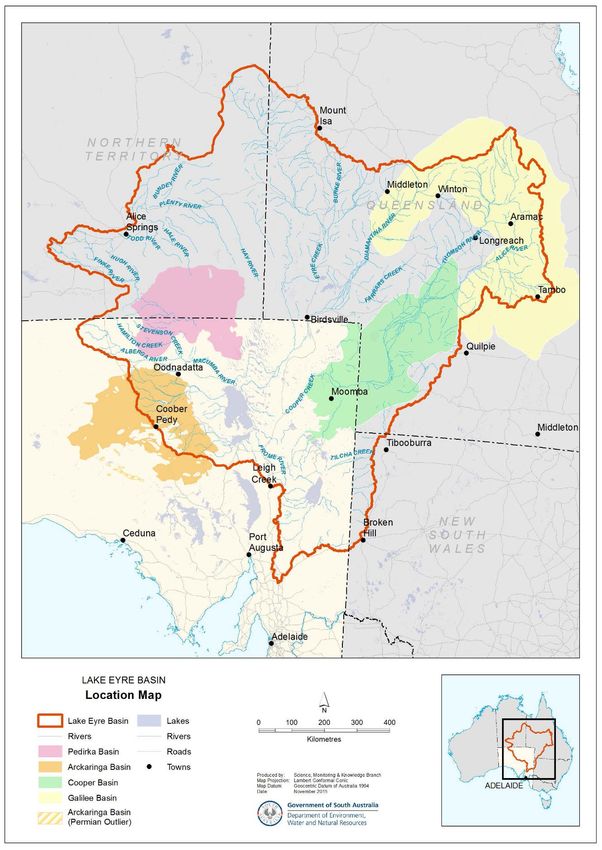
DEWNR Technical report 2015/49 2The LEBSA focuses upon groundwater dependent ecosystems (GDEs) of the regions surrounding the Galilee, Cooper, Arckaringa and Pedirka basins. (see Figure 1). The LEBSA project captures essential water asset information on GDEs including GAB springs in aligned SA and Qld datasets. The SA and Qld datasets, maps, and conceptual models will be used to support the National GDE Atlas. Figure 1: Map of the LEB, showing the geological basins DEWNR Technical report 2015/49 3
1.3 South Australian LEBSA project
This report is part of a series of studies that form the LEBSA project. The LEBSA project is one of three water knowledge
projects undertaken by DEWNR to inform the Bioregional Assessment Programme in the LEB. The three projects are:
Lake Eyre Basin Rivers Monitoring
Arckaringa Basin and Pedirka Basin Groundwater Assessment
Lake Eyre Basin Springs Assessment.
The South Australian LEBSA project focuses on groundwater dependent ecosystems (GDEs) within the regions surrounding the
Cooper, Pedirka, and the Arckaringa basins and provide to the Australian Government consistent information products on GDE
assets (including springs) for these sub-regions. These products will consist of GDE aligned and attributed datasets, maps, and
conceptual models.
Prior to the LEBSA, consolidated knowledge of the location, ecology and hydrogeology of the GAB springs was limited. There
was particularly poor understanding of the responses and potential impacts on springs from the water extraction activities
associated with coal mining and coal seam gas activities. These information gaps place significant constraints on the capacity
of governments to manage environmental risks associated with both the cumulative and individual impacts of CSG and large
coal mining developments. An initial step to addressing information gaps is the establishment of baseline data survey data and
the interpretation of such data for spring groups, ultimately to inform decision making of cumulative development pressures.
(Keppel et al. 2015a).
This report outlines the processes undertaken from a data management perspective for LEBSA, with the following associated
LEBSA Reports being closely linked:
A hydrogeological baseline characterisation of springs in the Neales River catchment and Lake Cadibarrawirracanna
regions, Lake Eyre Basin, South Australia (Keppel et al. 2015a)
A hydrogeological characterisation of springs in the vicinity of Lake Blanche, Lake Eyre Basin, South Australia, draft
(Keppel et al. 2016)
LEBSA Remote Sensing Reports – ‘GAB wetland area mapping, flow estimation’ (White et al. 2015) and ‘GAB wetland
diffuse discharge’ (Turner et al. 2015)
LEBSA GDE Mapping report (Miles & Costelloe 2015)
Ecohydrological conceptual models of springs in the western Lake Eyre Basin, South Australia, draft (Gotch et al. 2016).
1.4 Springs definition
The following definition of a spring was developed for the purposes of the LEBSA project
LEBSA project springs definition
A spring is a hydrogeological feature by which groundwater discharges naturally to the land or cave
surface. This includes springs with:
Permanent and non-permanent (i.e. intermittent or ephemeral) saturation regimes
Dynamic or static geographic locations; and
Diffuse or point source geographic locations.
The SA LEBSA dataset does include extinct springs however, information on these types of springs is limited.
Some standardisation of spatial hierarchy and nomenclature of GAB Springs had occurred prior to LEBSA, as part of an earlier
project Allocating Water and Maintaining Springs in the Great Artesian Basin Project (AWMSGAB NWC 2013)). During this
DEWNR Technical report 2015/49 4process, definitions and classifications were applied to spring attributes and groups of springs. Table 1 displays the definitions
used in South Australia, primarily based on hydrological parameters.
Table 1: SA spring classification hierarchy and definitions (source: Lewis, White and Gotch 2013)
Classification Definition and description
Supergroup Clusters of spring complexes; there are 13 supergroups across the GAB with three found in
South Australia
Complexe Clusters of spring groups that share similar geomorphological settings and broad
similarities in water chemistry
Group Clusters of springs that share similar water chemistry and source their water from the same
fault or structure
Spring Individual wetlands comprising one or more vents and tail joined together by permanent
wetland vegetation
Vents Individual point discharges of water from the GAB, varying in size and structure; some are
discrete discharges of water as if coming from a pipe, while others may be several metres
across with no clear point of discharge within the region – the spring vent is the minimum
unit used when describing the number of springs from a legislative perspective and in
accordance with water allocation planning
Tails Wetlands associated with flow away from the vent
Queensland had defined springs primarily based on spatial organization and distance (e.g. definitions as developed by
Fensham and Fairfax, 2003) whereby:
A spring group is a cluster of springs no further than 1 km apart and sharing a similar geomorphic setting.
A spring complex is a cluster of spring groups no further than 6 km apart and sharing a similar geomorphic setting.
A supergroup is a major regional cluster of spring complexes.
In order to promote consistency within the LEBSA project and facilitate integration of the LEBSA project work further the LEBSA
Technical Reference Committee have endorsed a ‘springs’ definition which is aligned between the states.
1.5 Aligned datasets and core attributes
In line with the broader aims of the Australian Government’s Bioregional Assessment Program to develop a national repository
to store bioregional assessment data, the LEBSA project was required to collate, align and ground-truth existing GDE data in
the LEB region. In addition to aligning and validating existing data, new data generated for the LEBSA project required a group
of attributes to be identified that could be used across the states.
Discussions were held between the SA and Qld LEBSA teams to determine how spring data in both states could be
standardised. The Qld team held springs data within a Microsoft Access database and SA held existing springs data within
DEWNR corporate databases (SA Geodata and BDBSA
Through a process of iteration it was decided that the solution to data alignment was to develop a mutually agreed list of
attribute definitions that could be used both nationally and internally by both states. Relevant data held within both the SA and
Qld databases could then be supplied to any future assessment methodologies knowing that attributes from each state were
like for like. For this process to work some changes would be required to both SA and Qld databases to align terminology and
definitions.
Initially a range of eco-physiological data attributes were identified. Following this, the LEBSA Technical Reference Committee
agreed upon a core list of attributes. It was noted that retrospective calculations or conversions could not be undertaken for
existing datasets. Once an attribute list was developed, a comparison between states was undertaken. Table 2 is a summary of
attributes that are being measured/collected by SA and Qld to date. In developing the aligned data model, Priority 1 are
essential attributes to collect, and Priority 2 are desirable attributes to collect.
DEWNR Technical report 2015/49 5Table 2: Priority data attributes
Area Field name Priority
Spring definition Discharge; Elevation; Horizontal location; Source Aquifers; Spring Wetland; Vent ID* 1
Spring Active; Area derivation; Estimated spring flow; Flow derivation; General Morphology; 1
morphology Mound length; Mound width; Relative mound height; Spring wetland length; Spring
wetland width; Spring wetland area; Surface Composition; Surface expression
(Saturation)
Condition/risk % connectivity; Excavation damage (proportion); Excavation damage (type); naturalness; 1
pH sediments; Pig damage; Stock damage; sulfate status
Water Conductivity; Hydrogeological Report Exists; pH; Temperature 1
Flora/fauna Opportunistic fish survey; opportunistic flora list; opportunistic flora list; 1
Photos Photo ID; Photo locations; 1
Spatial Complex polygon; group polygon; wetland polygon 1
Condition/risk Sulfate in water sulfide in sediment calcium carbonate in sediment 2
Water Isotope analysis; nutrient analysis 2
Flora/fauna Detailed fauna survey; detailed fish survey; detailed flora survey 2
*Some remote sensing data attributes were not collected for all springs, refer Clarke et al (215) and White et al (2015) for more
detail.
The agreed list of aligned spring attributes (Appendix B) was developed and signed off by both states. This now forms the basis
of all future GAB spring data collection and reporting in SA and Qld. Appendix B is a version of the metadata.doc and
describes:
which of the SA corporate databases the field is stored in (SA Geodata or BDBSA)
whether it is an existing field or one that required creation
description of the attribute (definitions/ methods)
allowed values.
It should also be noted that it was determined that within the LEBSA focus study area all data would be collected, with the
exception of the isotope, soil and water chemistry data. Data for these three data fields was collected for specific sites based on
the suitability for sampling, which is discussed in Keppel et al (2015a). There are also limitations in the ability to identify
invertebrates, but for each spring, reference samples were collected for future identification and DNA sequencing.
The aligned LEBSA dataset includes comprehensive information from available surveys including spring location, status
(active/inactive), and grouping (complex). Where available, information is also provided on physical properties, general
morphology, water chemistry, floristic composition, disturbance, faunal composition, survey effort, photographic
documentation, and historical descriptions. The dataset accommodates sufficient information to create a conservation ranking
at both the individual spring and complex levels.
1.6 Overview of the key tasks
A number of key data management tasks were required to meet the aims of LEBSA, including developing and gathering
baseline springs data and characterising, aligning and attributing the GDE water. These key tasks are summarized below and
discussed in more detail in the sections below:
Data audit, prioritization, gaps analysis and attribution (Section 2)
Data collection (Section 3)
Data management and access (Section 4)
DEWNR Technical report 2015/49 62 Existing data audit and prioritisation
2.1 SA springs data audit and project metadata
As part of the broader Bioregional Assessment Programme to align LEB GDE data, an initial assessment was undertaken to
identify relevant datasets and document knowledge of their properties. SA GAB spring’s data primarily constitutes spatial data,
hydrogeological data and biological data, which are stored separately in thematically based corporately managed databases.
The point of truth for location and hydrogeological data is SA’s authoritative groundwater and geology database known as
SA Geodata. The point of truth for SA biological data is the Biological Databases of South Australia known as BDBSA. Datasets
identified in the initial audit included both historic (pre 1980s to 2010s) and new data collected as part of the LEBSA in
2014/15. Some of the historic data had already been entered into the corporate databases, while some was field data sheets
and spreadsheets. Collectively the assessment identified data of varying types including:
General survey datasets (e.g. location, size, number of vents, spring group complexes, elevations, flow rates,
chemistry)
Photo points
Aerial imagery and remote sensing data
Relevant stand-alone databases
Corporate datasets or sections of datasets
Technical survey datasets (e.g. hydrological, flow data, avian, fish, social, flora, geological, cultural, invertebrates,
amphipods, general spring vegetation and threatened flora species).
A total of 21 datasets (see Table 3) were identified in this audit including data from long term projects stored in SA Geodata
and BDBSA. Each project was matched to an appropriate BDBSA project number in order to capture project details within the
BDBSA project metadata system, including the following:
Dataset name, project name
Data storage type (e.g. hard copy, spreadsheet or database)
Brief description of data, location, years of collection, number of vents assessed
Data type (e.g. general, bird, fish, hydrogeology etc.)
Data Authority (e.g. custodian or key contact)
Status (e.g. copy of data held within DEWNR, priority to track down).
New site data collected as part of the LEBSA gap filling program completes the final data audit which is listed in the table in
Appendix A. It is important to note this project metadata system documents data residing in BDBSA as well as non-biological
data that resides in SA Geodata. Detailed project metadata is available by looking up BDBSA project reference numbers (from
Table 3 or Appendix A) here on DEWNR website.
DEWNR Technical report 2015/49 7Table 3: Summary of the initial GAB springs data audit results
BDBSA project
Data reference No.
Initial dataset name Project name Region Priority Data authority Data type / description
ID (SURVEYNR)
Red=new
1 Mound Springs of SA (DEH) 130 Mound Springs Of SA (DEH) GAB SA 2 DEWNR General Survey
2 Badmans Bird Survey not registered yet Frank Badman’s Birds Lake Eyre Supergroup 3 Frank Badman Bird Survey
3 NCSSA 1978 680 MOUND SPRING SURVEY - 1978 NCSSA Statewide 1 DEWNR Photo points
PhD; Veg Ecology Dalhousie Springs –
4 Denise Noak P 942 Dalhousie 2 Denise Noak Vegetation
Noack
Mixed (macroinvertebrates,
Southern Lake Eyre
BHP Olympic Dam Wellfield A GAB Spring Flow Monitoring – WMC /
5 828 Supergroup / Northern 2 BHP Billiton flora, flow, chemistry,
Monitoring Program BHPB
Lake Frome
remote sensing)
GAB Spring Vegetation Monitoring - Lake Eyre Supergroup /
6 Fatchen & Fatchen 938 2 BHP Billiton / Fatchen Vegetation
WMC/BHPB GAB
Allocating Water and
Flinders Uni (Andy Love),
7 Maintaining Springs in the not BDBSA data AWMSGAB Statewide 2 Hydrological
SAAL / T Gotch
Great Artesian Basin
8 Kodrik Brown 945 & 946 Dalhousie Fish Surveys Dalhousie 2 Kodrik Brown Fish
The University of Adelaide Dalhousie and Lake Eyre Mixed (imagery flow, flora),
9 936 White & Lewis Mound Springs 2 Adelaide Uni (Megan Lewis)
Springs Projects Supergroup multiple projects
NCSSA Dalhousie/National Recovery Dalhousie / Lake Eyre
10 Ponder and Zeidler 942 1 Ponder Invertebrates (hydobiid)
Plan; Misc historic moundspring data Supergroups
11 Travis Gotch Honours / PhD 990 GAB SPRINGS FLORA & FAUNA (PHD) Statewide 1 T. Gotch Flora and fauna
Genetics of mound spring
12 Guzik, King and Murphy Data 947 SA Mound Springs 2 Guzik King and Murphy data Macroinvertebrates
macoinvertebrates
Chris Wilcox / Jess WW
13 945 Olympic Dam Wellfield A Monitoring Hermit Hill 3 QLD Museum Genetic?
(Queensland Museum)
14 EPA Macro-invertebrates not BDBSA data EPA Macro-invertebrates Statewide 3 EPA (contact TBA) Macroinverterbrate
1996 Niejalke WMC Springs GAB Springs Baseline Survey-WMC Statewide (excl. Detail Survey (spatial,
15 935 1 BHP Billiton
Survey 1995/6 Dalhousie) flora, invertebrates,
DEWNR Technical report 2015/49 8BDBSA project
Data reference No.
Initial dataset name Project name Region Priority Data authority Data type / description
ID (SURVEYNR)
Red=new
wetland extent)
16 SA Geodata not BDBSA data SA Geodata State Database Statewide 1 DEWNR Hydrogeological data
GAB Springs Expansion Study -BHPB inverts, plants, spring
17 Niejalke expansion study 933 GAB - Borefield C 2 BHP Billiton
2005 attributes
Social and ecological Survey
18 442 Mound Springs SVY (SEA 1985) Lake Eyre Supergroup 1 DEWNR General survey
of Mounds Springs 1984
19 SARDI Fish Data 851 SAAL wetland fish survey? 1 SARDI Fish
CFOC DESERT JEWELS DALHOUSIE FISH
20 New Dalhousie Survey 937 & 851 2 DEWNR Fish
SURVEY?
Whalen, Mackay, Clarke and MOUND SPRING ERIOCAULON - DAVIES
21 943 3 Flinders Uni (Whalen) Threatened flora
Davies data PHD
DEWNR Technical report 2015/49 92.2 Prioritisation and integration of SA springs data into DEWNR corporate
databases
From the initial data audit the 21 relevant springs data sets were documented through consultation with technical experts in
this field within DEWNR (e.g. Science, Monitoring and Knowledge Branch, South Australian Arid Lands NRM region), DSITIA, SA
and Qld Universities, SARDI, the South Australian Museum, private environmental consultants and industry (e.g. mining
companies), Office of Water Science (OWS), Bureau of Meteorology (BOM) and the Qld LEBSA team.
The preliminary list of spring datasets identified during the audit phase was then reviewed and data sets were given a priority
rating for entry into the relevant state databases for integration into the LEBSA project outputs. The priority ratings (listed in
Table 3) were based on availability of data sets yet to be integrated, timing of datasets and effort required to upload data:
1. High = significant datasets that are recent and available in electronic form
2. Medium = significant datasets with access/licensing and formatting issues. Where possible these were entered, some
remain outstanding.
3. Low = historically less significant (not filling a major gap) datasets requiring large effort to input. Where possible
these were entered, some remain outstanding.
The most recent data entered into BDBSA for the LEBSA is related to an ongoing PhD study (Gotch, in prep) and ongoing SAAL
GAB project observations (as part of the AWMSGAB). Most of the (location and hydrologic) springs related data for these
projects had been captured in SA Geodata whereas most biological data had not been entered into BDBSA until LEBSA.
Based on the priorities assigned, spring vent locations were validated and entered into SA Geodata as this is the point of truth
containing most up to date and accurate listing of all spring vents in SA. Some of the ‘aligned’ LEBSA attributes needed to be
created within the DEWNR corporate databases (SA Geodata and BDBSA), these are noted in Appendix B. Appendix C
illustrates the data form views that enable the aligned data to be entered in SA Geodata.
Once attribute modifications were made, and vents up to date, hydrogeological and geomorphological data was entered into
SA Geodata. Depending on the ability to resolve access or licensing issues, biological data was validated, checked for quality
and entered in BDBSA.
DEWNR Technical report 2015/49 103 Data management and access
Figure 2 illustrates how SA LEBSA data is aligned to Queensland LEBSA data, stored in DEWNR’s corporate systems and then
output for delivery in the flat tables format.
Figure 2: Summary of SA LEBSA Data storage and output
Management and access to SA LEBSA data is discussed in detail under the following topics:
1. Data entry and validation, including modification of state databases to accept aligned data model
2. Data output, into flat tables format, method to prepare for upload to Queensland Access database, spatial data and
access via the web
3. Photos management
4. Future data capture.
3.1 Entry and validation
Data from the 21 existing datasets along with data from new LEBSA field investigations (Gotch et al. 2016) were prepared and
entered as described below.
DEWNR Technical report 2015/49 113.1.1 SA Geodata
SA Geodata is the Government of South Australia’s corporate geoscientific data repository and captures groundwater and
mineral exploration data derived by industry reporting requirements and government exploration programs since the 1850s.
As the authoritative system for recording drillhole data, it stores mining, petroleum, groundwater, exploration and monitoring
data. The groundwater information stored in SA Geodata is used for reporting the state and condition of groundwater
resources across South Australia. It has been used to store GAB springs data for a number of years.
SA Geodata is the point of truth for spring location coordinates. Locations and vent-ids must be created here first before
hydrological and other related data can be entered. This is also the basis for generating spatial data layers in the DEWNR
corporate spatial data stores - various web enabled mapping applications can display these.
Spring locations and accurately surveyed elevation information for most of the vents in the 21 historic datasets identified in the
audit had already been entered into SA Geodata. However some of the associated hydrologic data including a number of the
LEBSA aligned attributes had not been entered. Modifications to SA Geodata were needed to ensure all of the aligned
attributes could be stored. This required a process of reconciling existing fields against the aligned ones and creating tables for
those not represented. In addition, lookup tables, code descriptions, forms to enter LEBSA data and views for exporting LEBSA
data were developed and implemented.
Once modifications to SA Geodata were complete, any vents not entered or newly surveyed were added, followed by entering
of any elevation, hydrological or photographic data available. Appendix E illustrates the data entry and maintenance forms for
the GAB springs component of SA Geodata.
3.1.2 BDBSA
The Biological Databases of South Australia are a suite of database applications that manage terrestrial South Australian biota
specimen and observation records. Critically, it includes systems that maintain the authoritative point of truth for taxonomy of
South Australian flora and fauna.
Biological records from the hardcopy and electronic datasets were extracted into corporate templates to load into BDBSA, with
basic validation and checking of hand written entries.
Due to the variation and age of data some key attributes were missing from historical datasets. For example, where the original
intent of the data collected was not focused on mound springs, often only the name of the broader spring complex or spring
group was recorded. In order to provide site locations for this biological data in BDBSA, coordinates were generated at the
centroid of the polygon for that complex or group, so as to create a dummy biological observation site. These are given a
spatial reliability related to the width of the group, to indicate uncertainty as to which vent the record is associated with. Other
more recent data where survey focus was mound springs had more precise GPS coordinates and/or vent-ids recorded.
Invertebrate data was formatted into the load template for BDBSA and had taxonomy validated as far as possible (some
samples to be identified by the SA Museum in coming months). This data was appended to the flat tables (see Sect. 3.2.1) as
BDBSA is currently unable to store these taxa. Developments to add invertebrate taxonomy to BDBSA are underway and these
records will be sourced from the corporate data stores following that.
3.2 Output
The full LEBSA datasets are held within SA Geodata and BDBSA and will be managed by DEWNR including maintenance of
taxonomy and entry of new data. DEWNR will always hold the point of truth for LEBSA data in SA and it should be extracted
when a full IESC assessment process requires it. For this reason, it is not advised to go about storing the current (snapshot in
time) flat tables in the Bioregional Assessment Information Platform. That system is designed to store data actually used in an
assessment as distinct from data likely to need updating before use in an assessment.
For some assessments (e.g. initial investigations) the aligned SA LEBSA data is supplied via four flat tables (Appendix B). This
can be ingested in to the Qld MS Access database by working through the process described in Section 3.2.2.
DEWNR Technical report 2015/49 12In addition, by storing data in DEWNR’s corporate systems, it is available via existing web applications. This includes most fields
in the Site table, Water Condition table and Species table. Opportunities may exist in the future to investigate best ways to
augment these applications, either with data fields from the Site Condition table or perhaps with a more integrated LEBSA
focused application and web services.
3.2.1 Flat tables
A series of repeatable processes have been established to extract aligned LEB Spring data from DEWNR’s corporate
information systems. These processes produce the aligned dataset described in Appendix B in the form of four flat tables. The
four output tables that will be produced by querying the relevant state databases are called:
Site table
Site condition table
Species table
Water table.
A fifth table listing photographs associated with vents will be supplied when the process of moving them from network folders
into SA Geodata has been finalized.
Biological data is extracted, processed and formatted via a series of tools in an ESRI® ArcGIS Toolbox to generate the species
flat table. This process is summarised below with technical details presented in Appendix C.
BDBSA records (from the suite of databases) are consolidated and updated weekly into two separate statewide spatial layers in
the DEWNR Corporate spatial data warehouse. These are known as the Flora and Fauna Supertables. The creation of the
species flat table starts with the supertable records and sub-sets or clips them to a five (5) kilometre buffer of the known spring
locations held within SA Geodata. This buffer is the stated distance from springs in the Far North Prescribed Wells Area Water
Allocation Plan (SAALNRMB, 2009), within which no new water wells are allowed for the purpose of extracting water and at the
boundary of which a cumulative drawdown threshold of 0.5 metres exists.
Many of the historic biological data records do not have a Vent ID stored with them, so a major function in the Toolbox is to
generate and assign a Vent ID to as many of the BDBSA records as possible in an automated way. The Toolbox then appends
the invertebrate records to the resulting species flat table, along with species related fields such as endemism.
Spring and hydrogeological data are more straight forward to deal with as SA Geodata fields match the aligned data schema
and all have vent-ids. The other three flat tables then are exported from a custom built view of SA Geodata that matches the
requirements of the aligned dataset.
3.2.2 Preparation to load flat tables into Qld Access database
It was decided that SA would investigate what issues there may be in transferring the flat tables into the schema of the Qld
Access database. While it is known that the data attributes align in definition between the states, it is differences in format and
structure of storage that make designing this transfer process non-trivial. This section (supported by Appendix E) describes
how to deal with issues encountered in transferring the species flat table into the Access database. It is known that similar
issues exist in transferring the remaining three tables, however these have not been documented as resolution would require a
collaborative approach and depend on specific decisions around apparent options.
It is acknowledged that the aligned nature of the data fields means that most of the data content will be compatible between
the state systems. The main issues for this transfer process relate to fields that are assumed to be internally unique to the
access database. This means that any values residing in corresponding BDBSA fields would need to be recalculated to ensure
internal referential integrity. For unique key fields that provide the relationships between tables, recalculation will be achievable
via unique values supplied. Specifically:
Visit_nr can be generated from sighting date and
observer_no can be generated from observer_name. Where multiple observers are recorded in the flat table, they will
need separating.
DEWNR Technical report 2015/49 13In addition to these internal references, and the need to append records to various look up tables, a process to harmonise
taxonomy between the states systems will be needed. Accordingly a taxon-id system just for this database will be needed
unless the National Species List approach used by Atlas of Living Australia can be adopted.
3.2.3 Spatial data
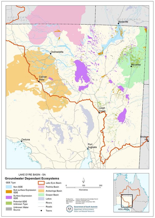
An ESRI® ArcGIS ‘file geodatabase’ containing the following GAB Springs (SA) datasets has been supplied. Vent related layers
extracted from the point of truth (SA Geodata) contain an ‘extract date’ field and are not maintained. Table 4 provides a
summary description of these data layers and links to metadata records:
Vent locations (points)
Vents buffered by 5 km (polygons)
Group Boundaries (polygons)
Complex Boundaries (polygons)
Supergroup Areas (polygons)
Vegetation Extents from Remote Sensing projects (polygons)(White et al, 2015)
Aquatic Ecosystem Mapping including GDEs (polygons)
Diffuse Discharge Areas from Remote Sensing projects (polygons)(Turner et al, 2015)
Figure 3 below illustrates the extent of SA GAB springs represented by vents, complexes and supergroups with aquatic
ecosystems mapping. Figure 4 breaks down the aquatic ecosystem mapping to show GDEs as in the National GDE Atlas classes.
Due to lack of data, the majority of these are of low or medium confidence at best.
DEWNR Technical report 2015/49 14Figure 3: Summary map of SA GAB Spring spatial data with Supergroups and Complexes named DEWNR Technical report 2015/49 15
Figure 4: Summary map of SA groundwater dependent ecosystem spatial data

DEWNR Technical report 2015/49                                             16
Table 4: Spatial data layers and metadata links
Data Layer Name Dataset Description Dataset Metadata Link
WATER_GABSpringVents Known location of GAB spring vents http://location.sa.gov.au/LMS/Reports/Re
from SA Geodata portMetadata.aspx?p_no=1566
WATER_GABSpringVents_Buffer_5km 5 km buffer of known location of GAB http://location.sa.gov.au/LMS/Reports/Re
spring vents from SA Geodata portMetadata.aspx?p_no=1567
LANDSCAPE_GABSpringGroups GAB spring group boundaries http://location.sa.gov.au/LMS/Reports/Re
portMetadata.aspx?p_no=1563
LANDSCAPE_GABSpringComplexes GAB spring complex boundaries http://location.sa.gov.au/LMS/Reports/Re
portMetadata.aspx?p_no=1569
LANDSCAPE_GABSpringSuperGroups GAB spring supergroup areas http://location.sa.gov.au/LMS/Reports/Re
portMetadata.aspx?p_no=1570
LANDSCAPE_GABSprings_WetlandVe GAB spring wetland vegetation extents http://location.sa.gov.au/LMS/Reports/Re
getationExtent_RS_2009 2009 portMetadata.aspx?p_no=1564
LANDSCAPE_AquaticEcosystems_GA Aquatic ecosystems (including http://location.sa.gov.au/LMS/Reports/Re
B Groundwater Dependant) portMetadata.aspx?p_no=1565
LANDSCAPE_DiffuseDischarge_Albed Diffuse discharge (albedo 85 and low http://location.sa.gov.au/LMS/Reports/Re
o85_LowTemperature temperature) portMetadata.aspx?p_no=1568
LANDSCAPE_DiffuseDischarge_Albed Diffuse discharge (albedo 90 and low http://location.sa.gov.au/LMS/Reports/Re
o90_LowTemperature temperature) portMetadata.aspx?p_no=1568
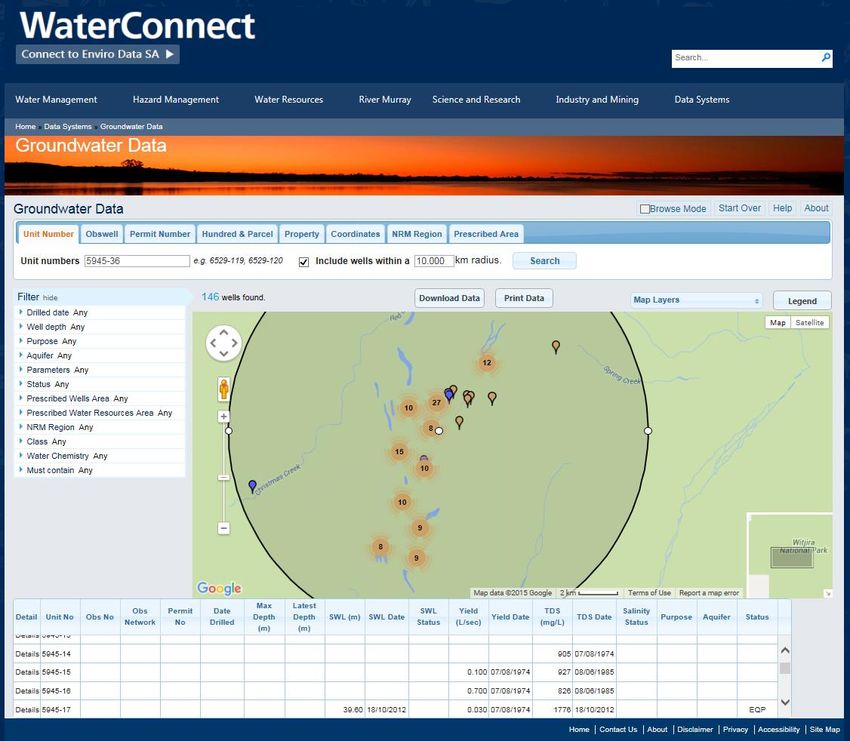
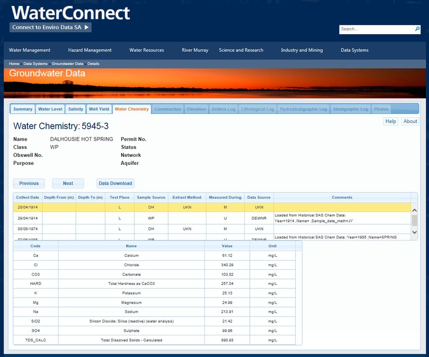
3.2.4 Web Access
The data contained in the Site table and Water Condition table is currently available via Groundwater Data in DEWNR’s
WaterConnect website, see example screen shots below in Figure 5 and Figure 6. Browse mode can be used, or Unit numbers
of springs (given in the spatial data set) can be entered to access location and water condition data. Note the two zeros in the
spatial attribute must be replace by a dash (-) when searching Groundwater Data: e.g. 59450036 becomes 5945-36.
DEWNR Technical report 2015/49 17Figure 5: Screen shot 1 of information for GAB Spring vents at Dalhousie Springs, Witjira National Park, SA DEWNR Technical report 2015/49 18
Figure 6: Screen shot 2 of Water Chemistry information for a vent at Dalhousie Springs, Witjira National
Park, SA

For web access to biological records, DEWNR have a process whereby BDBSA observations are uploaded to Atlas of Living
Australia (ALA) regularly. Appendix F describes how to access this data step by step if the following links malfunction, however
in summary the following links will take users straight to ALA and display records as stated:

 1.    All DEWNR biological records within 5 km of SA GAB springs as a list of Records View:
       http://biocache.ala.org.au/occurrences/search?q=qid:1446174292910%20-
       %20tab_recordsView%23tab_recordsView%20-%20tab_recordsView#tab_recordsView Note Species identified on the SA
       Environmentally Sensitive Data Register have their coordinates rounded to one decimal place and as a result may be up
       to 10 km from their sighting point. The spatial selection accommodates for spatial accuracy so these records will still be
       selected in the facet however the downloaded data will have generalised coordinates. Accurate coordinates for these
       records can be supplied upon request by DEWNR.

 2.    All DEWNR biological records within 5 km of SA GAB springs as a Spatial View:
       http://spatial.ala.org.au/webportal/?ss=5A407D14EA032475EF4428D704264009 Note see above
 3.    All ALA biological records within 5 km of SA GAB springs as a Spatial View:
       http://spatial.ala.org.au/webportal/?ss=73F9E796FAE91596CAE97AE42AAFBD56 Note Table 5 shows all ALA
       data providers relevant to this link (created October, 2015), which represent records potentially of significant value to

DEWNR Technical report 2015/49                                                                                                     19
any IESC assessment. Some of the records from SA Museum, Birdlife Australia and Australia’s Virtual Herbarium are
stored in BDBSA and therefore supplied in the species flat table. Metadata is available on each data provider and
individual datasets through the ALA metadata. This metadata can help decide what records will be fit for purpose.
Table 5: List of Data Providers from ALA data linked above
No of Records within
Data Provider
5 km of GAB Springs
Australian National Insect Collection, CSIRO 215
OZCAM (Online Zoological Collections of Australian Museums) Provider 5988
CSIRO National Fish Collection 1
BirdLife Australia 11745
Northern Territory Department of Land Resource Management 2
Citizen Science - ALA Website 4
South Australia, Department of Environment, Water and Natural Resources 11691
The University of Adelaide 34
Office of Environment and Heritage, Department of Premier and Cabinet 14
representing the State of New South Wales
Barcode of Life 18
Australia's Virtual Herbarium 9824
European Molecular Biology Laboratory Australia 18
Global Biodiversity Information Facility 91
Australian Seedbank Partnership 10
DigiVol 4
Total 39659
3.3 Photos
This project is facilitating the transfer of spring photographs from storage in network folders to more robust and ultimately
accessible storage within SA Geodata. This process was prioritized lower than documented data procedures and is continuing.
The photos and associated flat table will be supplied upon request.
3.4 Future data capture / monitoring
For future data capture and monitoring to be successful data management needs to be coordinated and in appropriate
formats. Processes that will assist this are as follows:
Development of clear streamlined processes for data capture and storage (both field and electronic data)
Use existing data to further identify gaps in current data and historic data
DEWNR Technical report 2015/49 20 Ensure data attributes are consolidated and consistent for efficiency, for example a subset of 10 key fields / attributes
could be established as a minimum and an additional agreed upon list could be available where projects have time,
funding and capacity to capture more data.
Clear data linkage pathways need to be defined, for example so that future data can be linked to old and new BDBSA
projects as appropriate
Timely entry of data load into corporate systems
Standardised template forms could be developed for tablets, along with an automatic upload system that efficiently
uploads data from a tablet into the database (with consideration that for SA, some data will be stored in the BDBSA
and some will stored in SA Geodata).
Development and implementation of the above processes and protocols should result in consistent classification and
attribution of GDEs across the LEB which will enable efficiencies in subsequent entry into national data frameworks. It is further
hoped that LEBSA datasets will continue to be expanded over time through continued investigation, data set integration and
enhanced integrated web access.
Future data capture that has already been identified includes:
Data gathered in the last 6 months (e.g. Mound Spring Vegetation Data collected by Jacobs for BHP; Mound Spring
Invertebrate Date collected by GHD for BHP, more recent Stygofauna data if now applicable to mound springs (South
Australian Museum / Flinders University).
DEWNR Technical report 2015/49 214 References Fensham RJ and Fairfax RJ, 2013, Spring wetlands of the Great Artesian Basin, Queensland, Australia. Wetlands Ecology and Management, 11:343-362 Gotch, T. (In prep). PhD Thesis focusing upon GAB Springs in South Australia. Gotch T, Keppel M, Fels K and McKenzie J, 2016, Lake Eyre Basin Springs Assessment: Ecohydrological conceptual models of springs in the western Lake Eyre Basin. DEWNR Technical report 2016/02, Government of South Australia, through Department of Environment, Water and Natural Resources, Adelaide. Keppel M, Gotch T, Inverarity K and Wohling D, 2015, A hydrogeological and ecological characterisation of springs in the vicinity of Lake Blanche, Lake Eyre Basin, South Australia, DEWNR Technical report 2016/03, Government of South Australia, through Department of Environment, Water and Natural Resources, Adelaide Keppel M, Inverarity K, Wohling D and Sampson Lloyd, 2015, A hydrogeological baseline characterisation of springs in the Neales River catchment and Lake Cadibarrawirracanna regions, Lake Eyre Basin, South Australia. Technical report prepared by DEWNR. Lewis MM, White DC and Gotch TB (eds) 2013, Allocating Water and Maintaining Springs in the Great Artesian Basin, Volume IV: Spatial and Remote Sensing of Artesian Springs of the Western Great Artesian Basin, National Water Commission, Canberra. Miles CR and Costelloe JF, 2015, Lake Eyre Basin (South Australia): mapping and conceptual models of shallow groundwater dependent ecosystems, DEWNR Technical note 2015/22, Government of South Australia, through the Department of Environment, Water and Natural Resources, Adelaide National Water Commission, 2013, Allocating water and maintaining springs in the Great Artesian Basin, Volume VII: Summary of findings for natural resource management of the western Great Artesian Basin, NWC, Canberra. South Australian Arid Lands Natural Resources Management Board (SAALNRMB) 2009, Water Allocation Plan for the Far North Prescribed Wells Area, South Australia. Turner D, Clarke K, White D and Lewis M, 2015, Mapping areas of Great Artesian Basin diffuse discharge, DEWNR Technical report 2015/55, report by the University of Adelaide to the Government of South Australia, through Department of Environment, Water and Natural Resources, Adelaide. White D, Schofield B and Lewis M, 2015, Great Artesian Basin spring wetland area mapping and flow estimation, DEWNR Technical report 2015/54, report by the University of Adelaide to the Government of South Australia, through Department of Environment, Water and Natural Resources, Adelaide. DEWNR Technical report 2015/49 22
Appendix A                        GAB springs data projects as recorded in DEWNR project metadata system, including summary of
                                  BDBSA records

                                                                                                                                              Access or
                                                            BDBSA     BDBSA
   BDBSA                                                                        BDBSA     START         END               Data                  Open
                                  SURVEY NAME                Fauna     Flora
 SURVEYNR*                                                                       Sites    DATE          DATE       Authority/Custodian        Licensing
                                                            records   Records
                                                                                                                                                Issue
     130        MOUND SPRINGS OF SA (DEH)                                                 1/08/1997    1/08/2001   DEWNR                         Yes

                                                                                                                   Scientific Expedition         No
     161        DALHOUSIE (SEG)                               225       170       47     12/07/2003   26/07/2003
                                                                                                                   Group & DEWNR
     175        WABMA KARDARBU MOUND SPRINGS                   1        257      520      5/05/2004   19/05/2004   DEWNR                         No
     442        BIO ASSESS - SA MOUND SPRINGS (SEA 1985)       4        239       81      1/01/1900    1/01/2020   DEWNR                         No

                                                                                                                   Nature Conservation           No
     680        MOUND SPRING SURVEY - 1978 NCSSA              460       247       39      1/01/1977   31/12/1978
                                                                                                                   Society of SA Inc

                                                                                                                   BHP Billiton & WMC            Yes
     828        GAB SPRING FLOW MONITORING - WMC/BHPB                                     1/01/1989   31/12/1990
                                                                                                                   Resources Ltd
                                                                                                                   South Australian Arid         No
     851        SAAL WETLAND FISH SURVEYS                    44830                99      1/01/2006    1/01/2020
                                                                                                                   Lands NRM
                                                                                                                   South Australian Arid         No
     894        GAB SPRINGS FLORA & FAUNA                     13       1827      4492     1/01/1999    1/01/2020
                                                                                                                   Lands NRM
     933        GAB SPRINGS EXPANSION STUDY -BHPB 2005                                    1/09/2005   30/09/2005   BHP Billiton                  Yes
                                                                                                                                                 Yes
                                                                                                                   WMC Resources Ltd &
     935        GAB SPRINGS BASELINE SURVEY -WMC 1995/6                                   1/01/1995   30/12/1996   Royal Geographic
                                                                                                                   Society of SA
                                                                                                                                                 Yes
                                                                                                                   University of Adelaide &
                                                                                                                   SA Arid Lands NRM &
     936        WHITE & LEWIS MOUND SPRINGS                                               1/01/2007   31/12/2013
                                                                                                                   National Water
                                                                                                                   Commission (NWC)

     937        CFOC DESERT JEWELS DALHOUSIE FISH SURVEY                                  1/01/1900    1/01/2020   Unknown                       Yes

DEWNR Technical report 2015/49                                                                                                                            23
Access or
BDBSA BDBSA
BDBSA BDBSA START END Data Open
SURVEY NAME Fauna Flora
SURVEYNR* Sites DATE DATE Authority/Custodian Licensing
records Records
Issue
BHP Billiton & WMC Yes
938 GAB SPRING VEG MONITORING - WMC/BHPB 1/01/1980 1/01/2020
Resources Ltd
941 VEG ECOLOGY DALHOUSIE SPRINGS - NOACK 1/01/1992 31/12/1995 Researcher Yes
942 MISC AND HISTORIC MOUND SPRING DATA 136 172 138 1/01/1900 31/12/1999 Unknown No
Flinders University of SA Yes
943 MOUND SPRING ERIOCAULON - DAVIES PHD 1/10/1999 1/03/2002
& BHP Billiton
CSIRO Sustainable Yes
945 DALHOUSIE FISH SURVEY -KODRIC-BROWN 1991 1/07/1991 1/01/1992
Ecosystems
University of New Yes
946 DALHOUSIE FISH SURVEY -KODRIC-BROWN 2003 1/08/2003 1/10/2003
Mexico & CSIRO
University of Ad & SA Yes
947 MOUND SPRING INVERTS - MURPHY/GUZIK/KING 1/09/2007 30/06/2013 Museum & DEWNR &
Latrobe & NWC
944 GOBIES IN LAKE EYRE BASIN - MOSSOP PHD 1/10/2010 31/01/2014 Monash University Yes
Commonwealth No
990 LAKE EYRE BASIN SPRINGS ASSESSMENT 47 194 53 1/07/2014 31/12/2015
Government & DEWNR
* Further details for each SURVEYNR including types of data
collected available at:
http://apps.environment.sa.gov.au/emap/envmaps-query.do?cmd=su.SurveySummaryMain
DEWNR Technical report 2015/49 24Appendix B List of data fields that form the ‘aligned’ national GAB spring database
SA Geodata BDBSA
Table Name Field Name Description Allowed Values
Field Field
Unique identifier for an individual spring vent. Multiple vents rom the same
Site Table Vent ID existing Primary Key, Text
wetland are differentiated using underscore and a number.
Numerical identifier for spring wetland. Numbers with the prefix “-“refer to
Site Table Site Number new Primary key, >= 0
potential spring locations that have been searched but no spring found.
Site Table Name existing European name Text, Blank
Site Table Aboriginal name new Aboriginal name Text, Blank
Site Table Synonym new Other names that the spring have been known by Text, Blank
Name of property/pastoral station/national park on which spring wetland is
Site Table Property Name new LUT, Text, Blank
located
Spring group code in SA this is the same as the three letter code at the
beginning of the vent id i.e. HWF in HWF003. (SA Data). Springs are naturally
Site Table Group Number existing Text, Blank
grouped and derive water from a similar fault or fracture and largely have
similar water chemistry
(SA Data) Spring group name as summarised in Gotch (2013) Volume IV.
Site Table Group Name new Text, Blank
AWMSGAB
Name of spring complex to which spring wetland belongs. Slight variations
on how this is derived exist between states. In Queensland a complex
represents a group of springs or spring-groups such that no adjacent pair of
springs or spring-groups is more than about 6km distant and all springs
Site Table Complex Name new within the spring-complex are in a similar geomorphic setting. South LUT, Text, Blank
Australia has no distance criteria, Complexes are naturally clustered Spring
Groups located in a similar geomorphological setting. Geomorphic setting
includes geological unit, landform, landscape position or soil type. Complexes
can contain both active and inactive springs.
DEWNR Technical report 2015/49 25You can also read