Bicycle & pedestrian plan update - DRAFT 6 March 2014 - Gainesville-Hall County Metropolitan Planning Organization - Gainesville Times
←
→
Page content transcription
If your browser does not render page correctly, please read the page content below
Gainesville-Hall County Metropolitan Planning Organization

                         bicycle & pedestrian
                                  plan update
                                                   DRAFT
                                              6 March 2014
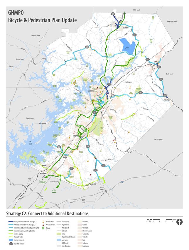
table of contents

INTRODUCTION                                           2

EXISTING CONDITIONS IN HALL COUNTY                     4

NEEDS & OPPORTUNITIES                                  20

RECOMMENDATIONS & IMPLEMENTATION PLAN                  24

                                        DRAFT Bicycle & Pedestrian Plan Update   |   1
introduction
            Hall County is a unique and richly diverse county in north Georgia. From the urban activity of Gainesville,
            to the natural beauty found in the rolling pastures of Hall County’s horse farms, the region offers countless
            reasons for residents to take to the streets on foot or on bike. This document is the product of collaboration
            between Hall County and its eight cities and is intended to document community needs, establish an
            improvement strategy with policy and project recommendations, and identify potential sources of funding
            in order to create and maintain a vibrant and well-connected walking and biking network.

            Background of the GHMPO Bicycle and Pedestrian Plan
            In 2005, the Gainesville-Hall Metropolitan Planning Organization (GHMPO) began developing its first
            countywide bicycle and pedestrian plan in preparation for the forecasted growth that was identified in Hall
            County’s 2004 Long Range Transportation Plan (LRTP). The MPO worked with county staff and the cities of
            Gainesville, Oakwood, Flowery Branch, Lula, Clermont, and Gillsville to inventory the existing facilities, collect
            community input on needs and demand for walking and cycling facilities, and develop implementation
            strategies to achieve the vision and goals set forth by the plan’s participants. In addition to working with
            several of Hall County’s cities, the MPO coordinated efforts with the Georgia Department of Transportation
            (GDOT), and the Georgia Mountains Regional Development Center (GMRDC), which is now known as the
            Georgia Mountains Regional Commission (GMRC). The 2006 plan used the collected information to make
            recommendations for projects, supporting policies and programs, ways to increase public awareness,
            funding, design standards, and plan monitoring.

            Purpose of the Partial Update
            An important recommendation that was made in the 2006 GHMPO Bicycle and Pedestrian Plan is the continued
            monitoring and updating of the plan as conditions change in Hall County. The estimated population growth
            in the county will bring transportation challenges and will require ever-evolving strategies to meet those
            challenges. Therefore, the relevance of the bicycle and pedestrian plan, along with its recommendations, is
            dependent on periodic updates.
            This partial update to the 2006 GHMPO Bicycle and Pedestrian Plan focuses on the development of multi-
            use trails to provide off-road facilities for cyclists and pedestrians. One benefit to having wider trail sections
            in place is that they serve to maximize the potential for use among many different types of user groups.
            However, consideration was also given to other facility types such as sidewalks and bikeable shoulders,
            whenever applicable.

2   |   Gainesville-Hall County Metropolitan Planning Organization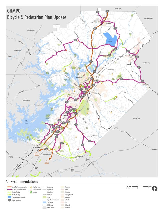
Scope of Study
The scope of this study was a twofold approach including a technical analysis of current facilities and
conditions and discussion with a technical working group designed to promote interaction and collaboration
amongst Hall County’s cities.
The technical analysis consisted of an inventory of existing facilities and programmed projects in the county’s
Transportation Improvement Plan (TIP) and the 2040 Metropolitan Transportation Plan (MTP). Additionally,
community destinations for walking and biking trips, such as parks and universities, were identified as being
important locations for improved connectivity. Transit-dependent areas of the county were identified using
socio-economic data, auto-ownership data, and population density figures from the 2010 U.S. Census.
The group interaction took place over four monthly Advisory Committee meetings. This committee was
made up of MPO staff as well as GDOT District 1 engineers, city officials, city managers, and county engineers.
These meetings consisted of an interactive workshop designed to help identify specific needs for each city;
thoughtful discussion of plan goals, objectives and strategies for implementation; and evaluation of project
recommendations and implementation timeframe.
A draft of the plan was presented to the Hall County Technical Coordinating Committee (TCC), the Citizens
Advisory Committee (CAC), and the Policy Committee (PC) for review prior to the upcoming update to the
Long Range Transportation Plan.

Goals and Objectives
The 2006 plan established a foundation for the direction the county wished to take regarding walking and
biking facilities. Overall, county staff decided to broaden the network of trails, seek to educate citizens, and
to promote safe riding habits among them.
After reviewing the technical information and the input from the technical advisory committee that was
collected as part of this plan update, several goals and objectives have been identified. The Existing
Conditions section of this report provides detail on each of these goals, and why they have been included in
the plan update.

  2014 GHMPO Bike and Pedestrian Plan Update Goals and Objectives
  •   Goal One: Promote active lifestyles by providing access to recreational trails in Hall County.
      o    Objective 1A: Create destination trails connecting to and through major passive parks.
      o    Objective 2A: Develop community programs to support active living.
  •   Goal Two: Provide bicycle connections to high demand areas.
      o    Objective 2A: Connect trails to colleges and universities.
      o    Objective 2B: Connect trails to K-12 schools and parks.
      o    Objective 2C: Connect trails in areas of higher residential density with low auto ownership.
  •   Goal Three: Support city redevelopment plans through bicycle and pedestrian connections.
      o    Objective 3A: Support development of walkable and bikeable corridors as community focal
           points.
      o    Objective 3B: Support city comprehensive plan objectives for redevelopment through
           increased accessibility.
  •   Goal Four: Improve long distance cycling through the county and region.
      o   Objective 4A: Provide signed, on-street bicycle routes for distance riders along lower volume
          roads.
      o   Objective 4B: Connect to key destinations in surrounding counties.

                                                                         DRAFT Bicycle & Pedestrian Plan Update    |   3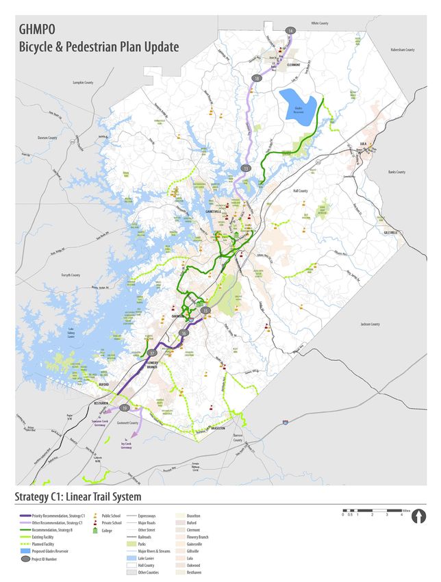
existing conditions
            Review of Existing Plans
            Since the original 2005-06 GHMPO Bicycle and Pedestrian Plan was drafted, several comprehensive plans,
            master plans, and redevelopment plans have been prepared. Each of these plans include several pedestrian
            components designed to improve accessibility within downtown areas, promote healthy living, and
            enhance connectivity around important destinations and transit routes. An extensive review of these plans
            was conducted to pinpoint community goals along with relevant projects to incorporate into this update.
            Additionally, to coordinate efforts with individual municipalities, the consulting team conducted site visits to
            each city and held meetings with city staff members and elected officials.

            GHMPO Bicycle and Pedestrian Plan (2006)
            The original Bicycle and Pedestrian Plan set the framework for the county’s vision for alternative modes of
            transportation. The plan envisioned a well-connected bicycle and sidewalk network with many on-street
            and street-adjacent facilities such as sidewalks, bicycle lanes, and wide curb lanes. The State Bike Route 55
            was determined to be a suitable “trunk” for this bicycle network. Branching facilities from this on-street trunk
            were recommended to provide access to schools, parks and downtown areas. Facility type, such as wide curb
            lane or bike lane, was determined based on vehicle volumes, available right-of-way, and posted speed limits.
            Sidewalks were recommended on most streets within the cities. Priority was given to roads that were shown
            to already be heavily traveled by pedestrians (as indicated by worn strips along the roadside) or to important
            destinations like employment centers.
            These street-adjacent recommendations were made to reduce overall project costs by limiting the amount
            of new right-of-way needed while also providing access to key destinations. Multi-use trails, which can be
            adjacent to a road or off-road, were recommended when a connection between corridors was needed, but
            characteristics such as narrow right-of-way or heavy traffic volumes limited the use of an on-street facility.
            Trails were also recommended if the facility helped to enhance community initiatives, such as preserving
            open space. Figure 1 illustrates the 2006 plan’s recommendations.
            Along with prioritized project recommendations, the plan suggested several policies and programs the
            county should consider to improve awareness of walking and biking benefits, to educate users on correct
            procedure and lawful behavior when using these facilities, and to begin building sufficient funding sources
            in the forms of grants, SPLOST monies, and other local sources. One important recommendation was the
            modification of the cities’ current development ordinances to require pedestrian and bicycle facilities and
            amenities be constructed with new developments.
            Safety was addressed by recommending the adoption of minimum design standards based on the
            American Association of State Highway and Transportation Officials (AASHTO), GDOT, and the Federal
            Highway Administration (FHWA) standards. These standards would need to be adopted by each jurisdiction
            individually. The plan also recommended that accident data involving pedestrians should be collected on a
            yearly basis to monitor safety trends and to identify areas in need of additional improvement.
            Maintaining sidewalks, trails, and bike facilities can be a costly endeavor; therefore, the 2006 plan
            recommended incorporating the construction of wide curb lanes and/or bike lanes into road resurfacing
            projects. The plan also suggested that a web-based system be implemented to allow the public to inform
            city and county staff about maintenance needs. This would provide the public with the means to be actively
            involved in improving their community and would also reduce costs associated with monitoring pavement
            conditions.

4   |   Gainesville-Hall County Metropolitan Planning Organization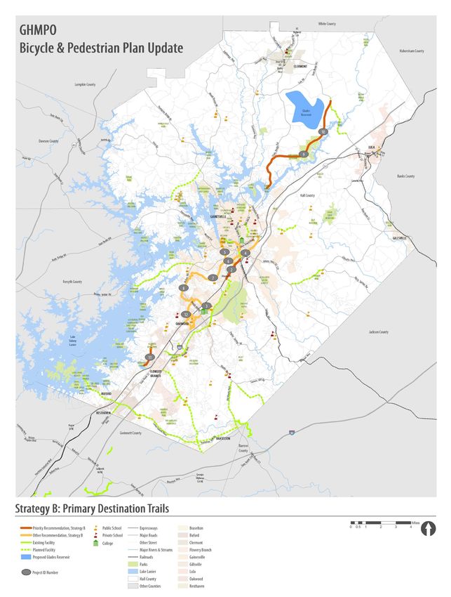
Figure 1.   Proposed Bicycle Network, 2006 GHMPO Bike/Ped Plan

                                                                 DRAFT Bicycle & Pedestrian Plan Update   |   5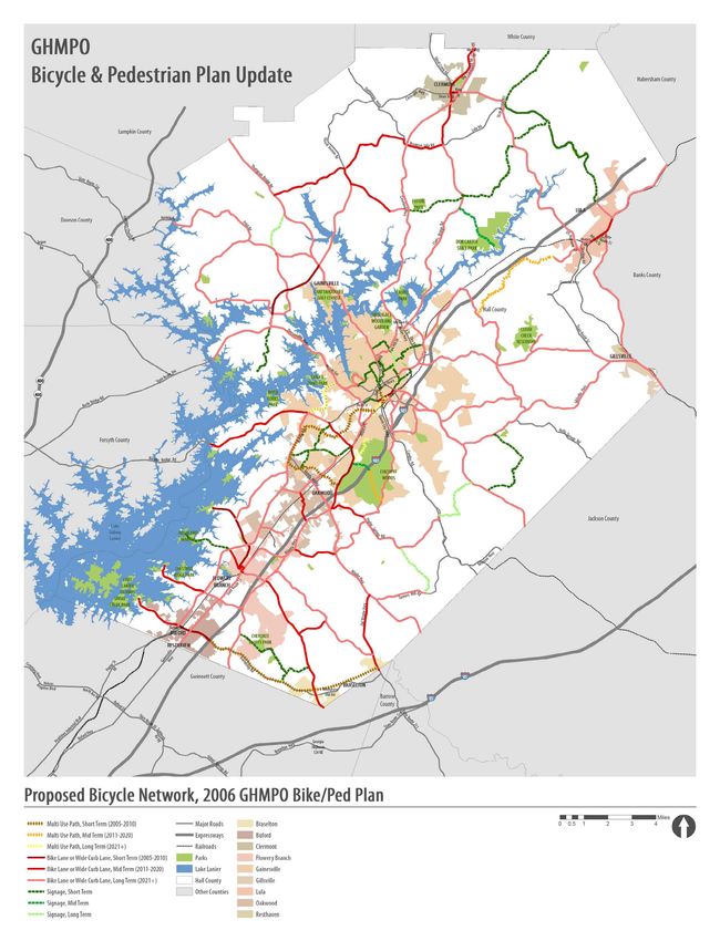
existing conditions

             GHMPO 2040 Metropolitan Transportation Plan (2011)
             The GHMPO 2040 Metropolitan Transportation Plan (MTP) is a comprehensive planning document that
             sets forth the Gainesville-Hall metropolitan area’s short-term and long-term vision for its multi-modal
             transportation system. This plan adheres to federal guidelines set forth in the Safe, Accountable, Flexible,
             Efficient Transportation Equity Act: A Legacy for Users (SAFETEA-LU). The 2040 MTP was drafted in 2011 to
             supplement findings from the previous 2030 Long Range Transportation Plan (LRTP), drafted in 2007. The
             2040 MTP also serves as an update for funding allocation of short- and long-term projects within the MPO
             boundaries.
             The 2040 MTP recognized the need for the Gainesville-Hall MPO region to begin to consider alternative
             modes of transportation when planning future projects, especially in a cost-effective and logical manner.
             One major challenge to biking and walking projects that was identified in this plan is that a very large
             majority of residents rely heavily on automotive travel to reach places of employment and other daily living
             destinations. Therefore, a large portion of available funding was devoted to roadway enhancement projects,
             such as road widenings and new connections. Certain roadway projects such as the Lanier Islands Parkway/
             SR 347 widening (PI# 162430 – GH-007) and the Spout Springs Road widening (PI# 0009679 – GH-023) do
             incorporate multi-use trails into design concepts. Several other roadway project concepts include sidewalks
             and/or bike lanes. Additionally, funding was set aside for construction of a new segment of the Central
             Hall Trail within the short-term Transportation Improvement Plan (TIP), and approximately $6,900,000 was
             allocated as a lump sum for bicycle and pedestrian improvements in the mid- and long-range sections of
             the implementation guide. Figure 2 illustrates programmed projects from the 2040 MTP and indicates
             whether or not they contain a bicycle or pedestrian component.
             Lastly, the 2040 MTP recommended that the region and its individual jurisdictions adopt a Complete Streets
             Policy that is in line with national and state guidelines. This policy would make sidewalks (or multi-use side
             paths) a requirement on most new roads and would require that some form of alternative travel means be
             considered in road widening designs as well.

             City of Flowery Branch Downtown Transportation Study (2010)
             The city of Flowery Branch conducted a 2010 study to determine needed transportation improvements within
             its downtown area. This study was based on city land use plans, previous comprehensive planning efforts,
             technical engineering analysis, and community input. One important multi-use trail/greenway identified
             in this study is the Alberta Banks Park to City Park trail. The trail first appeared in 2005 in the 2025 Flowery
             Branch Comprehensive Plan. Funding was not available for many of the projects identified in this plan, and,
             ultimately, the trail was not included in the 2006 GHMPO Bicycle and Pedestrian Plan. The City of Flowery
             Branch Downtown Transportation Study reintroduced this trail as an important amenity and recommended
             that right-of-way for the facility be preserved until a time when funding could be provided. The proposed
             alignment lies along mostly undeveloped parcels, and this study suggested that the city work with future
             developers to reserve, and possibly fund construction of this trail.

6   |   Gainesville-Hall County Metropolitan Planning Organization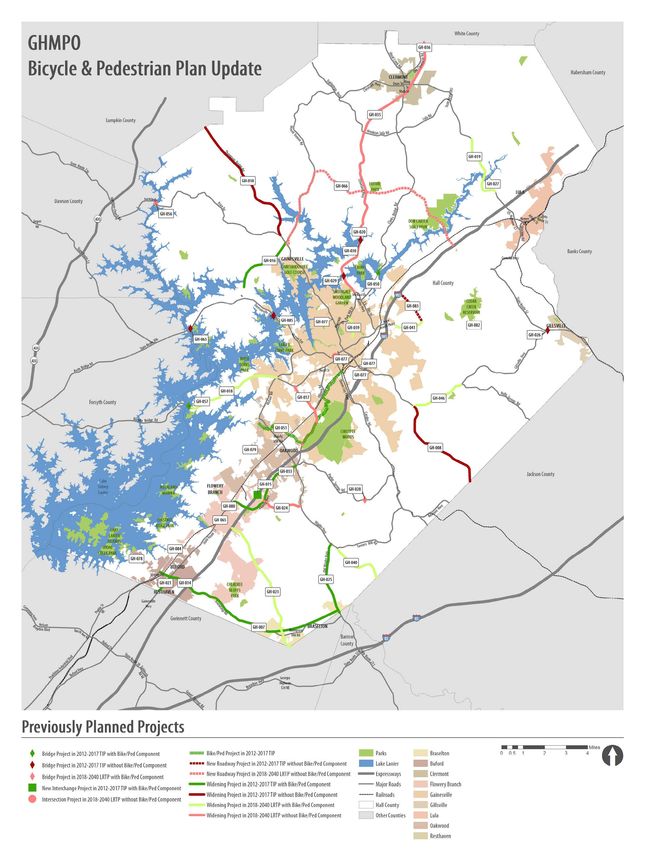
existing conditions

Figure 2.   Previously Planned Projects

                                          DRAFT Bicycle & Pedestrian Plan Update    |   7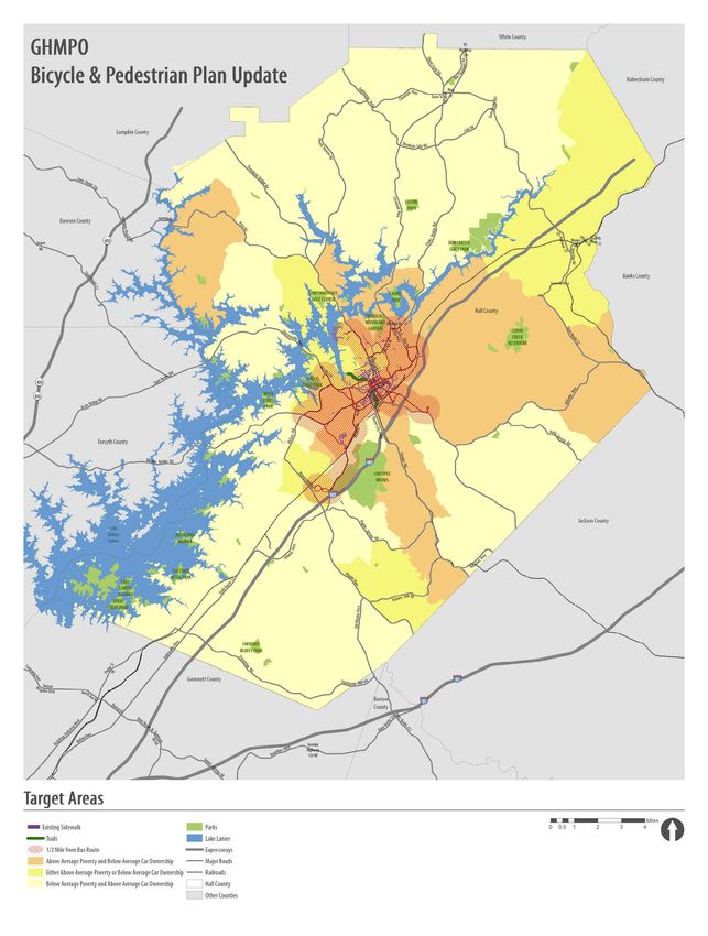
existing conditions

             Flowery Branch Old Town Redevelopment Plan (2013)
             The previously mentioned 2025 Flowery Branch Comprehensive Plan
             recommended that the historic Old Town area of the city undergo
             substantial redevelopment to improve the sense of community and to
             revitalize the economic growth in the area. To support the redevelopment
             goals of the city, this plan recommended several roadway improvements
             along with five greenways and sidepaths. The recommended sidepaths
             include 10’ wide facilities along Phil Niekro Boulevard into town, and
             along Lights Ferry Road to the Aqualand Marina located on Lake Lanier.
             Community park improvements recommended for the Flowery Branch
             City Park located along the waterfront include the addition of a short 10’
             wide path along the lakeshore. A short trail from Lights Ferry Road to
             Pine Street is proposed as part of the redevelopment of a parcel west of
             the Department of Public Works. Lastly, an implementation strategy for
             the City Park to Alberta Banks Park trail is outlined. The trail would require
             working with developers to construct the trail in segments, as various
             properties are developed in downtown Flowery Branch. This trail system
             is identified as being a key component to the overall redevelopment of
             the city, as it provides access to the Old Town area, the lakefront, and
             neighborhoods.

             City of Gainesville Transportation Master Plan (2013)
             The city of Gainesville developed its Transportation Master Plan in 2013.
             In order to develop a recommended project list through 2040, the plan
             considered information from previous planning documents such as the
             Gainesville 2030 Comprehensive Plan and the GHMPO 2040 Metropolitan
             Transportation Plan. Several pedestrian and cyclist projects were
             recommended as part of this plan, including expanding the multi-use
             trail network in downtown Gainesville by including a 10’ wide trail along
             Pearl Nix Parkway from the existing Rock Creek Greenway to the existing
             Midtown Greenway at Martin Luther King Jr. Boulevard. A second 10’
             wide trail is proposed in the midtown area of Gainesville as part of a new
             roadway connection from Industrial Boulevard to Jesse Jewell Parkway,
             northeast of Downey Boulevard.
             Additional pedestrian and cycling improvements were recommended in
             downtown Gainesville in the form of sidewalks, sharrows, and complete
             street/streetscape projects. A complete street is one that accommodates
             not only vehicular traffic, but pedestrian and cyclist traffic as well. Often,
             elements such as landscaping and lighting are included to make the
             street more attractive to non-automotive travelers. Trip generators such
             as Brenau University, Gainesville Square, and places of employment
             drive the demand for these types of amenities. This plan recommends
             completing most of these projects in the short- to mid-term time frame.

8   |   Gainesville-Hall County Metropolitan Planning Organization
existing conditions
2030 Oakwood Comprehensive Plan (2009)
The city of Oakwood has a 2030 comprehensive plan which outlines
the community’s vision for long-term growth. A large part of this
vision involves preserving natural green space and providing residents
with trails and parks for enjoyment and recreation. Within the city’s
proposed town center area lies nearly three miles of natural greenways
that follow existing streambeds. The City of Oakwood, Georgia
Comprehensive Plan proposes to develop this town center destination
area with retail, mixed-use facilities, office parks, and community
amenities. These natural greenways will serve as trail connections
between the varying districts outlined in the city’s plan.
Gwinnett, Jackson and White Counties
The Gwinnett County Greenways & Open Space Master Plan Update, which was developed in 2013, includes
several recommended projects along natural greenways. Gwinnett County’s existing trails that are relevant
to Hall County’s plan are a segment located at George Pierce Park in Suwanee, Georgia, and a segment
between the Gwinnett Environmental & Heritage Center and the Mall of Georgia. Proposed projects would
extend both of these trails north towards the Gwinnett/Hall County line along Suwanee Creek and Ivy Creek,
respectively.
The Jackson County greenways plan, Connect Jackson, which was drafted in 2011 draws recommendations
based on potential connections to Hall County. These recommendations were made based on the project list
found in the 2006 GHMPO Bicycle and Pedestrian Plan. Connect Jackson proposes installation of a wide curb
lane along SR 332 from the county line into Talmo, a wide curb lane on Gillsville Highway/SR 52 from Gillsville
southeast toward Maysville, and a bike lane on Winder Highway/SR 53 from the county line into Braselton.
Shared use paths are also proposed along the greenway corridors of Mulberry Creek, Walnut Creek, Allen
Creek, Pond Fork, North Oconee River, and Candler Creek. These recommendations were preliminary, and
a detailed implementation guide with project timeframes and costs were not provided as part of this study.
The White County Bicycle and Pedestrian Plan was drafted and adopted in 2011. Two relevant projects that
are given mention in White County’s plan are the Gainesville and Northwestern Historic Rail Bed trail and the
Mossy Creek trail. The proposed Gainesville and Northwestern Historic Rail Bed trail would make use of an
existing railroad alignment that, at one time, extended from Gainesville to just north of Helen. The alignment
primarily follows the existing US Highway 129. The project vision is somewhat similar to the Silver Comet
Trail, which follows an old railroad bed and extends from the Georgia/Alabama state line to the outskirts
of Atlanta. The Mossy Creek trail is briefly mentioned and described as a 10.25 mile trail which begins in
downtown Cleveland and extends southeast along the Mossy Creek bed to the Hall County line. The proposed
trail would terminate at the Chattahoochee River in the Mossy Creek State Park. As with the Jackson County
greenways plan, these project recommendations are preliminary, and a detailed implementation guide with
timeframes for design and construction are not provided.
DRAFT Bicycle & Pedestrian Plan Update | 9existing conditions
Existing and Programmed Trails
There are currently approximately 5 miles of paved and unpaved walking and biking trails in Hall County.
The University of North Georgia also has approximately 3.5 miles of unpaved mountain bike trails, while the
Chicopee Woods Park boasts a 21-mile system for off-road biking purposes. The ongoing project known
as the Central Hall Trail will gain almost 3 more additional miles of multi-use trail in 2014-15 as another
segment along Palmour Drive and Atlanta Highway/SR 13 reaches completion. Widening projects along
Spout Springs Road and Lanier Islands Parkway which are currently under design and construction will have
adjacent segments of 10’ multi-use paths as well.
Comparatively, Cobb County, located in the metro-
Atlanta area, has approximately 48 miles of paved multi-
use trails and side paths, including the Silver Comet
Trail and the Kennesaw Mountain to Chattahoochee
River Trail. As another example, existing sections of the
Atlanta BeltLine extend for approximately 10 miles as it
makes its way around the city of Atlanta. The vision of
the BeltLine is a continuous 33-mile multi-use trail loop
connecting parks, neighborhoods, business and transit.
Both of these cases are the realization of extensive
planning efforts, dedication, and cooperation and are
examples of what can be achieved within the rapidly
growing Hall County.
Atlanta BeltLine
Gainesville – Midtown Greenway, Rock Creek Greenway
Gainesville is the largest and most populous city in Hall County. Its downtown is characterized by a mixture
of offices, higher education facilities, medical facilities, restaurants, and retail interspersed with small parks
and a section of lakefront green space along Longwood Cove.
The Midtown Greenway is an existing section of the larger Central Hall Trail network and is part of the city’s
redevelopment plan for its downtown and midtown areas. The 10’ wide trail follows an old railroad bed from
just north of Parker Street to Martin Luther King Jr. Boulevard in Gainesville’s midtown area. A second phase
of construction is scheduled to begin in 2014 which will extend this trail further south to the intersection of
Pine Street, Industrial Boulevard, and Georgia Avenue. With the completion of this phase of construction, the
trail will be approximately 2/3 of a mile long.
The Rock Creek Greenway, which opened in 2009, is
an approximately 2-mile long trail of 10’ and 8’ wide
sections that connect from Longwood Cove on Lake
Lanier to downtown Gainesville. The greenway
passes through Longwood Park, Wilshire Trails, Ivey
Terrace Park, and Rock Creek Park. It is a heavily
used trail for residents in the area, and its southern
terminus at Rock Creek Park is only 0.5 miles from
the Midtown Greenway. Figure 3 shows these two
trails, along with several planned connections
that make up the larger Central Hall Trail network.
Rock Creek Greenway
10 | Gainesville-Hall County Metropolitan Planning Organizationexisting conditions
Figure 3. Gainesville: Multi-Use Trails
DRAFT Bicycle & Pedestrian Plan Update | 11existing conditions
Flowery Branch – Sterling on the Lake Side Path
One short segment of multi-use trail currently exists within the city limits of Flowery Branch. This section
of trail is located within the Sterling on the Lake subdivision off Spout Springs Road. The trail begins at the
development entrance and extends approximately 2,960’ along Lake Sterling Boulevard. Expansion of this
trail would make it an important link between paths proposed on Spout Springs Road and Lanier Islands
Parkway/SR 347. The trail is also adjacent to the developing Cherokee Bluffs Park. Planned amenities in the
park include mountain biking trails, hiking and walking trails, and a disc golf course.
Braselton – Mulberry Creek Walk (unpaved)
The city of Braselton has built an unpaved walking trail
along Mulberry Creek which extends from Thompson Mill
Road in Barrow County to a northern terminus east of Old
Winder Highway/SR 211. The city plans additional phases
for this trail to extend further south into Barrow County,
as well as further west into Hall County along the creek.
The current trail is approximately 2.5 miles long and has a
compacted earth base.
Hall County –Lanier Islands Parkway Trail, Spout
Springs Road Trail, Central Hall Trail
Several planned trails have received or are expected
to receive programmed funding within the next 10
years. These planned facilities are largely located in
unincorporated Hall County. With the exception of a
segment of the Central Hall Trail (PI# 0007639 – GH-051),
these planned paths are incorporated into roadway
reconstruction efforts. Designing for pedestrians and
cyclists is required under the Georgia DOT Complete
Streets policy, and this is a cost effective way to improve
walkability while also improving vehicular conditions.
Lanier Islands Parkway/SR 347 is programmed for reconstruction in the 2012-2017 TIP, and plans will
incorporate a 10’ multi-use side path along the road east of I-985, with bike lanes and sidewalks recommended
along much of the road to the west of I-985. Construction has already begun on some segments of SR 347
and is expected to continue until 2016. The estimated length of the entire roadway project is 12.1 miles.
The widening of Spout Springs Road from Hog Mountain Road to the Gwinnett County line is expected to
be a more long-term project. Sections of this road are currently being designed with either an adjacent 10’
multi-use path or 5’ sidewalks. The total project length is 6 miles and is currently expected to be completed
in 2020.
The Central Hall Trail Loop is an ongoing project to create a connected, 16-mile circuit which would run
between downtown Gainesville and Oakwood. The previously mentioned Midtown Greenway and Rock
Creek Greenway in Gainesville are part of the trail. Construction of another segment of the trail is expected
to begin in 2014, with the segment expected to open in late 2014 or early 2015. This section will run from
Palmour Drive to the University of North Georgia, Gainesville Campus in Oakwood. Future off-road segments
of the trail are proposed along Balus Creek and Flat Creek, while street-adjacent segments will lie along
Aviation Boulevard, Palmour Drive, and McEver Road. Each completed segment of this loop will be an
exciting and important step towards a long-standing community goal. Figure 4 illustrates these existing
and planned trail segments.
12 | Gainesville-Hall County Metropolitan Planning Organizationexisting conditions
Figure 4. Gainesville Area: Central Hall Trail Route
DRAFT Bicycle & Pedestrian Plan Update | 13existing conditions
High Demand Areas
Pedestrian and bicycle traffic have been shown to be higher in areas that exhibit certain characteristics.
Areas of higher population density tend to generate more walking and biking trips. Certain socio-economic
conditions like an above average poverty level or a lower auto-ownership level can lead to neighborhoods
and regions that rely heavily on transit and other alternative modes of travel. Schools and universities and
the areas surrounding a campus are expected to promote higher volumes of foot and bike traffic as well. The
following sections describe these high demand areas in greater detail.
Areas with high population density
The 2010 U.S. Census recorded the current population of Hall County at 179,684 people. The 2000 Census
recorded the county’s population at 139,277, which indicates a total population increase from 2000 to 2010
of 40,407, or 29%. The 2040 MTP estimated that the population in 2008 would be approximately 184,824.
2010 Census data suggest the predicted growth for the county was reasonably accurate and indicates that
strong population growth is occurring within Hall County. The county is approximately 274,758 acres, or
429.3 square miles in size. The average population density in 2010, therefore, was 0.65 persons per acre.
Population density is a relative measurement, and for the purposes of this study, the following assumptions
regarding density have been made:
• Less than or equal to 0.5 persons per acre ~ Low Density
• 0.51 – 1 person per acre ~ Medium Density
• 1.01 – 2 persons per acre ~ High Density
• Greater than 2 persons per acre ~ Very High Density
Figure 5 shows that the area within downtown Gainesville and southwest of Gainesville has a very high
density, relative to the rest of the county. It is within these areas that demand for walking and biking facilities
can be expected to be greater. Another important observation from this figure is that the population density
along the I-985 corridor from Gwinnett County to Gainesville and Lake Lanier is considered to be high density.
The rest of the county falls into the medium to low density range. It is of note that the area in southeast Hall
County between Winder Highway and Candler Road is at medium density, as well as portions of eastern Hall
along Athens Highway/US 129, and in northwest Hall along Thompson Bridge Road/SR 60 and Dawsonville
Highway/SR 53. While a high demand for multi-use paths, sidewalks, and other biking facilities may not
currently exist in these areas, this mid-level density characteristic may indicate a trend of development that
could lead to a greater demand in the future.
14 | Gainesville-Hall County Metropolitan Planning Organizationexisting conditions
Figure 5. Population Density
DRAFT Bicycle & Pedestrian Plan Update | 15existing conditions
Areas with above average poverty levels and low auto-ownership levels
The U.S. Census Bureau estimates that, as of 2012, the median household income in Hall County is $52,174.
The Bureau also estimates that 16.8% of the county’s population lives below the poverty threshold, which is
dependent on factors such as household size and cost of living. For the purposes of this study, a census tract
with an estimated poverty level greater than 14% was labeled as being more transit dependent. In addition
to this, census data relating to auto ownership was used to identify areas in the county where there were
a significant number of households which did not own a vehicle. This study considered census tracts with
a no-auto ownership rate greater than 5% to be a target area with an elevated dependency on transit and
other forms of transportation.
Figure 6 illustrates areas of Hall County exhibiting one or both of these contributing factors. Regions of
note include much of Gainesville, the rural portions of the county east of Gainesville, the Athens Highway/US
129 corridor, and west Hall along Price Road and Cool Springs Road.
Universities
Hall County is home to both Brenau University and the University of North Georgia’s Gainesville campus.
Brenau University is an all-female collegiate institution located in downtown Gainesville. The university was
founded in 1878 and currently has a population of approximately 745 students. The University of North
Georgia was recently formed through the consolidation of two important schools in the region. The former
Gainesville State College campus became the new Gainesville Campus of the University of North Georgia in
January 2013. Student body numbers for 2012 (prior to the consolidation) indicate that approximately 8,659
undergraduate and graduate students attended the school during that academic year.
These two campuses, and the area surrounding them, should be considered points of high demand for
cyclists and pedestrians. Factors that contribute to this elevated demand include the age of the average
college student, the amount of parking that is available on campus, the costs incurred to drive and park on
campus, and the overall lifestyle choices of the average student. With all of this taken into consideration,
universities become excellent locations to improve and encourage alternative transportation methods. By
providing safe, well-lit, and aesthetically appealing facilities, students can be encouraged to opt for a bike
instead of a personal vehicle as his or her primary mode of travel to and from school. This has an added
benefit to the universities as it reduces the amount of parking spaces needed to accommodate growing
campuses. Reducing the number of personal vehicles parked on campus is a challenge that many colleges
and universities face across the country, regardless of the size of the institution. Lastly, by encouraging
students to walk or bike rather than drive, the overall air quality is improved significantly.
Brenau University University of North Georgia
16 | Gainesville-Hall County Metropolitan Planning Organizationexisting conditions
Figure 6. Target Areas
DRAFT Bicycle & Pedestrian Plan Update | 17existing conditions
Hall Area Transit (HAT) routes and access
Figure 7 details the bus routes for Gainesville, Oakwood and Hall County. HAT provides a weekday bus
service along these routes known as the “Gainesville Connection.” HAT also provides dial-a-ride services
for riders of all types, including an exclusive service for the disabled called “Mobility Plus.” Transit service
is limited in Hall County as there are currently no long distance routes to destinations like Flowery Branch,
Braselton, Buford, and Gwinnett County.
The hatched buffer in Figure 7 represents the area located within 0.5 mile of existing routes. This is roughly
the distance that a person is willing to walk as part of a longer trip requiring transit and is sometimes referred
to as the “last mile.” Last-mile connectivity is a transit term that refers to the “last mile” that a person who
has taken transit is required to travel to reach his/her destination. This “last mile” is an important step of a
person’s trip but it is often overlooked. Planned facilities for walking and biking should strive to improve
connectivity within this buffered region.
Coordination with Cities
Input regarding the existing conditions and areas of need for the county and its municipalities was collected
through various methods. The consulting team made site visits to each of the eight cities within Hall
County to inspect conditions of existing facilities, to investigate potential amenities and destinations, and
to meet with city staff and elected officials if possible. Additionally, a technical advisory committee made
up of city and county staff and elected officials was formed and asked to attend four discussion sessions
scheduled throughout the planning process. The intent of this committee was to create a collaborative plan
that involved all eight cities of Hall County. The committee participated in a workshop designed to identify
important projects and destinations and was also instrumental in the development of the plan’s strategies
and recommendations.
18 | Gainesville-Hall County Metropolitan Planning Organizationexisting conditions
Figure 7. Hall Area Transit (HAT) Routes
DRAFT Bicycle & Pedestrian Plan Update | 19needs & opportunities
The input and data that was collected as part of the existing conditions inventory was then used to identify
areas where the need for new facilities was greatest. Four main areas of need emerged from the technical
advisory committee sessions:
• Complete the existing facilities in Hall County
• Create new destination trails for recreational purposes
• Develop a north-south linear spine trail
• Improve connections in high-demand areas
These needs became the basis for an implementation strategy and are described in greater detail in the
following sections.
Complete Existing Facilities
As previously mentioned, Hall County has plans to develop the 16-mile Central Hall Trail loop which would
connect Gainesville and Oakwood along with both universities in the area and several parks. This trail is
expected to primarily be a recreational feature but would also serve other trip purposes as well. The current
alignment runs through some of the more populous areas in Hall County and would be expected to receive
significant use upon completion.
The existing segments of this planned trail are known as the Rock Creek Greenway and the Midtown Greenway.
These two trails are not part of the loop itself, but are part of a large spur that is planned to connect with the
circuit. Currently, the existing facilities offer short connections, but as future phases are completed, the loop
would grow and serve a variety of purposes by connecting the cities of Gainesville and Oakwood.
The unofficial name of this loop is the Central Hall Trail, however in one of the advisory committee workshops,
the idea of branding the trail was discussed. This could include a new name, a common logo which would
appear on all portions of the trail, and even similar design standards. All of these features would serve to
make the trail one cohesive loop rather than a patchwork of paths. Making these improvements would go a
long way toward increasing awareness, generating public support, and prioritizing funding. Not only would
naming this trail and prioritizing its completion be important steps to developing a county trail network, but
it would also serve as an example of how careful planning and dedication can result in a very special and
unique feature that county residents can use and be proud of.
20 | Gainesville-Hall County Metropolitan Planning OrganizationCreate Destination Trails
The topic of a destination trail was brought up in several advisory
committee meetings with the intention of generating renewed
excitement at the public level for the future of Hall County’s
trail system. This type of trail would be primarily recreational
in nature and would need to be extensive enough to draw
visitors from around the county. Studies have shown that these
types of recreational trails can improve property values on
adjacent parcels and can act as an economic stimulus for nearby
businesses. The Big Creek Greenway in neighboring Forsyth
County is an excellent example of a successful destination trail.
One example of a Hall County destination trail that should Big Creek Greenway
be prioritized in the county’s long range plan is the previously
mentioned Central Hall Trail. A second destination trail proposed
in this plan is a multi-use, off-street facility which begins at Clarks
Bridge Park, follows Clarks Bridge Road north to an undetermined
point, and then turns east towards the Don Carter State Park. The
trail in this section would be off-road and would wind through
hilly terrain and largely undeveloped property. The trail could
enter the state park via the main gate, or through a secondary
access point on the park boundary. Coordination with the state
park and the Department of Natural Resources would be required
to determine access points and trail alignment through park
property. An intriguing characteristic of the Don Carter State
Park is the high volume of equestrian traffic that is generated
from nearby horse farms. The opportunity exists to align this
walking/biking path parallel to equestrian trails in some areas to
truly capture the unique character of north Hall’s horse farming
history. The trail would leave the state park to the northeast,
and continue along the Chattahoochee River, ending at SR 52/
Lula Highway. A programmed roadway project to widen SR 52 in
this area is tentatively scheduled to open in 2021. Bike lanes are
planned as part of this widening. Don Carter State Park
Other, shorter trails in and around downtown centers could
serve as smaller destination trails as well. Trails connecting
within town centers have been considered in various city plans
for both Flowery Branch and Oakwood. The City Park to Alberta
Banks Park trail in Flowery Branch has been proposed in the
redevelopment plan for the city, which was drafted in 2013. The
proposed implementation plan outlines working with private
developers to construct most of the trail in conjunction with parcel
development in the Old Town area of Flowery Branch. A similar
situation exists in Oakwood, where the master plan for the town
center and surrounding commercial and office parks includes
many miles of trails and preserved green space. Developers
would ideally be encouraged to construct trail sections as parcels
are developed. Both of these trail systems should continue to be
pursued and should be designed to connect to the linear spine
trail.
DRAFT Bicycle & Pedestrian Plan Update | 21needs & opportunities
Develop a Linear Spine Trail
As growth along the I-985 corridor in southern Hall County continues, connections between new and existing
developments are needed to provide residents with multi-modal transportation options. Efforts should be
made to connect residential neighborhoods, schools, parks, downtown areas, commercial developments,
office parks and other community centers, much like the Atlanta BeltLine does for the city of Atlanta. A single,
connected trail from Gainesville to Buford would serve the cities of Gainesville, Oakwood, Flowery Branch ,
and Buford. A similar linear trunk trail was proposed in the original 2006 GHMPO Bicycle and Pedestrian Plan
along the State Bike Route 55. This linear spine trail should also be incorporated into planned networks in
Gwinnett County to provide a connection across county lines to the proposed Suwanee Creek Greenway or
the Ivey Creek Greenway found in the Gwinnett County Greenways & Open Space Master Plan. Shorter, spur
trails leading from this central spine would serve to connect to town centers, neighborhoods, and other
previously mentioned facilities. Ultimately, the trail could also extend north from Gainesville to Clermont
and the White County line as development expands northward.
Opportunities exist to complete this linear spine trail by including sidepath components into MTP 2040
road widening projects along such major thoroughfares as Buford Highway/SR 13, Atlanta Highway/Falcon
Parkway, McEver Road, and Cleveland Highway/US 129. Additional opportunities lie along the linear arterial
roads of Thurmond Tanner Parkway and Hog Mountain Road. While these roads are not currently programmed
for widening, conditions such as available right-of-way, and proximity to the University of North Georgia and
Lanier Technical College, neighborhoods and the town centers of Oakwood, Flowery Branch, and Buford
make each route a viable option for the addition of a multi-use trail.
If growth continues to move northward as it is expected to, additional demand for multi-modal transportation
will rise. As a future goal, this linear trail/path should continue north of Gainesville and extend to the White
County line. The ideal location for this facility would be along Cleveland Highway/US 129. The entire section
of road is approximately 13.6 miles, which is a very long distance for the average cyclist. Therefore, the
primary user of the facility would be the Class A (Advanced) rider. Class A riders typically prefer riding with
traffic streams, either in bike lanes or on wide shoulders. As the area develops, the user demographic may
change from these long distance cyclists to more casual riders or even pedestrians. Due to the long-term
nature of this recommended project, facility type should be determined at a later date.
The Atlanta BeltLine is an example of a spine trail that links neighborhoods, schools, parks, commercial
areas, and other community centers.
22 | Gainesville-Hall County Metropolitan Planning Organizationneeds & opportunities
Connections in Areas of High Demand
Zones of higher demand for cycling and pedestrian travel are described in greater detail in the Existing
Conditions section of this document. These high demand zones are places of higher population density,
areas in close proximity to the University of North Georgia and Brenau University, and areas with an elevated
dependency on transit services. Users in these zones would access the facilities with the primary purpose of
traveling to work, school, transit stops, or other community facilities.
The City of Gainesville Transportation Master Plan
recommends many improvements to streets in the
downtown area. These recommendations range from
installation of sharrows on Spring Street to complete
streets and streetscapes along sections of Washington
Street, College Avenue, Main Street, and Bradford
Street. These pedestrian improvements will enhance
walkability and bikeability on streets in very close
proximity to Brenau University.
Another desirable location for a multi-use side path is
along Thurmond Tanner Parkway between Flowery
Branch and Oakwood. This segment of trail would serve
as an important connection between the two cities as
part of the linear spine trail, but would also serve the Complete Streets shown in blue (from the Gainesville Transportation
high demand area centralized around the University of Master Plan)
North Georgia and Lanier Technical College. Students
living in the area could make use of a path on a daily basis to travel to school and back home. The trail will
also be important to the city of Oakwood as its town center master plan is realized.
Target areas identified as having above average poverty levels and lower auto ownership levels can be found
in both urban, higher-density areas and rural, lower-density areas. These target areas that lie in very high or
high density areas should be considered for improvements that provide access to transit stops (if applicable)
and important community facilities such as hospitals, schools, and retail. These necessary destinations
tend to be clustered together when located in urban settings, and therefore trip distances are expected to
be relatively short. The 2006 GHMPO Bicycle and Pedestrian Plan states that a reasonable estimate for the
distance a pedestrian is likely to walk is 0.25 miles. The same plan states that cyclists are likely to ride up to
5 miles one-way per trip. Therefore, appropriate facility types will consider both walkers and cyclists and
could include sidewalks, bike lanes, and multi-use paths, although wide curb lanes could be implemented if
right-of-way conditions are limited. AASHTO standards in the 2012 Guide to Bicycle Facilities, 4th Edition, state
that the minimum bike lane width in most urban settings is 5’. Posted speed limits, heavy bicycle traffic,
and on-street parking are some of the factors that drive the recommended bike lane width and should be
considered on a case-by-case basis. Generally, the minimum required width for sidewalks is 5’, but wider
facilities are recommended when possible.
Target areas that have a lower density character should focus on providing long-distance facilities since
important destinations tend to be farther apart in these rural areas. Priority consideration should be given
to cyclists due to the longer distances between trip ends. Typical road sections in rural areas do not include
curb and gutter, therefore, appropriate treatments are either wide shoulders/outside lanes or 10’ multi-use
paths. Wide shoulders are generally more cost effective per linear mile than multi-use paths and can be
completed with routine resurfacing projects. They also serve to reduce roadbed wearing over time and
provide refuge spaces for vehicles that need to park. AASHTO standards state that the minimum width to
accommodate bicycle traffic on a paved shoulder is 4’ when curb is not present and 5’ when curb, guardrail, or
other obstructions could impair the cyclist’s movement. This minimum width would also provide reasonable
walking space for pedestrians in rural areas, although sidewalks or wider shoulders should be considered if
space permits.
Areas of note include eastern Hall County and the area between Candler Road and Winder Highway in
southeastern Hall County. Due to the more rural nature of the county in these areas, sidepaths may not be as
feasible as in urban and suburban areas. The corridors are lengthy and destinations are more widely spread
out, making construction of a path costly and less effective. In these areas, wide shoulders or wide outside
lanes for biking are preferred and can be included in road widening or resurfacing projects.
DRAFT Bicycle & Pedestrian Plan Update | 23recommendations & implementation plan
Recommendations
To implement the following list of project and policy recommendations, three strategies were developed
based on the technical analysis conducted by the consulting team and on the discussion and input received
from the plan’s advisory committee. These strategies are shown on the following page. The order of each
of these three strategies suggests their relative importance; however, this is designed merely to serve as a
guideline for implementation. It may be that some strategies overlap, and in some instances it may make sense
to complete a component of Strategy C before one from Strategy B. The needs of the community, available
funding, or any other number of reasons may alter the order in which these strategies are implemented.
From these strategies, a list of recommended projects was developed and is found in Table 1 on page
26. The projects are ranked by the total number of plan objectives that each one meets. A detailed table
with project descriptions and prioritization information can be found in the Appendix of this document.
Projects highlighted in green have been identified as “high priority”. These projects either benefit one of the
recommended destination trails or they complete an important section of the trunk trail in areas of higher
population density. Figure 8 accompanies this list and shows the entire recommendations map with
project numbers. Small-scale city maps of these projects can be found in the Appendix of this document.
24 | Gainesville-Hall County Metropolitan Planning OrganizationADOPT A PLAN FRAMEWORK
A1. Brand the Trail Network or Key Trail Sections, such as the Central Hall Trail Loop.
• Provide a common name and brand for the primary trail.
• Seek corporate sponsorship for trail sections.
• Partner with local hospitals and the Health Department to promote the health benefits of
walking and cycling.
A2. Adopt a Plan for Implementation and Maintenance across Multiple Jurisdictions.
• Develop a project implementation committee (Involve representatives from the cities, county,
and cyclist community).
• Identify cost sharing relationships and provide a unified approach for funding of major projects.
• Develop common policies for sidewalk and trail requirements for new development and
consider application of fee-in-lieu to fund implementation of logical pieces of the network.
BUILD PRIMARY DESTINATION TRAILS
B1. Construct Initial Network of Multi-use Trails from Gainesville to Oakwood.
• Finish design and construction of the Central Hall Loop.
• Connect the Central Hall Loop to the Midtown Greenway and to the University of North Georgia.
• Connect the Midtown Greenway to Ivey Creek Trail through Downtown Gainesville.
B2. Create a Destination Trail along the Chattahoochee River from Gainesville to North Hall County.
• Create a multi-use trail within the Don Carter Park.
• Extend the multi-use trail from the Don Carter State Park to Clarks Bridge Park and to Lula Park.
• Coordinate with Don Carter Park Master Plan and potential reservoir project.
B3. Create Destination Trails in Oakwood and Flowery Branch.
• Construct the City Park to Alberta Banks Park Greenway in Flowery Branch.
• Implement planned projects from the Oakwood Town Center Master Plan.
CREATE LINEAR TRAIL SYSTEM
C1. Create a Linear Trail System Connecting Clermont to Buford along the I-985 corridor.
• Include a trail component in planned widening projects.
• Connect to city downtowns, parks, and universities.
• Connect to planned networks in Gwinnett, White, and Jackson Counties.
C2. Expand Trail System by Providing Additional Connections and Destinations.
• Connect Cities of Gillsville, Lula, and Clermont to one another and to the trunk trail.
• Provide additional connections to Cities and Parks.
C3. Create Parallel Routes Along I-985 Corridor in South Hall County.
• Support preferred linear trail with additional alignments east and west of I-985.
• Primary connections should lie along McEver Road, Atlanta Highway, and Thurmon Tanner
Parkway.
DRAFT Bicycle & Pedestrian Plan Update | 25recommendations & implementation plan
Strategy B Projects
Strategy Proj. # Name Length (mi.)
B.1 1 Central Hall Trail: Downtown Greenway Connector 0.6
B.1 2 Central Hall Trail Loop: Palmour Drive Connector 2.2
B.1 3 Central Hall Trail Loop: Balus Creek Route 1.9
B.1 4 Industrial Boulevard Extension * 1.9
B.1 5 Pearl Nix Parkway Trail West * 1.7
B.1 6 Pearl Nix Parkway Trail East * 1
B.1 7 Central Hall Trail Loop: Flat Creek Route ** 4.5
B.1 8 Central Hall Trail Loop: McEver Road Greenway Connector 1.2
B.2 9 Feasibility Study for Don Carter State Park Trail N/A
B.2 10 Don Carter State Park Trail 8.3
B.3 11 City Park to Alberta Banks Park Greenway *** 1.3
B.3 12 Oakwood Town Center Trail System 5
Strategy C Projects
Strategy Name Length (mi.)
C.1 13 GH-020 US 129 Bike Lanes - Limestone Pkwy to Nopone Rd ~ 5.4
C.1 14 GH-036 US 129 Bike Lanes - Clarks Bridge Rd to White Co Line ~ 2.7
C.1 15 SR 13/Atlanta Hwy Trail - Bike Lane Conversion 1.2
C.1 16 GH-033 SR 13/Atlanta Hwy Trail - Radford Road to SR 53/Winder Hwy ~ 4.5
C.1 37 GH-080 SR 13/Atlanta Highway Trail - Lanier Islands Pkwy to Phil Niekro Boulevard ~ 3.3
C.1 18 GH-035 US 129 Bike Lanes - Nopone Rd to Clarks Bridge Rd ~ 5.6
C.1 19 Study to determine connection to Gwinnett County Greenway System N/A
C.2 20 Gainesville Complete Streets-Washington St, Fair St, Prior St, Bradford St, Main Street, College Ave * N/A
C.2 21 GH-040 Winder Highway/SR 53 Trail -Tanners Mill Road to I-85 in Jackson County ~ 2.6
C.2 22 Cherokee Bluffs Park Trail 2.4
C.2 23 Lakeview Drive Sidepath 3.8
C.2 24 Aqualand Marina Path *** 2.2
C.2 25 Limestone Creek Trail 1.7
C.2 26 County Line Road Trail 4.8
C.2 38 Gillsville - County Line Road Trail 0.9
C.2 39 Lula - County Line Road Trail 0.9
Corridor Study to determine route and facility type based on projected growth/demand northwest of
C.2 27 Gainesville N/A
C.2 28 GH-025 Old Winder Highway/SR 211 Trail - Winder Hwy to Gwinnett County Line ~ 3.3
C.2 29 Winder Highway/SR 53 Multi-use Trail - Atlanta Hwy/SR 13 to GH-040 4.7
C.2 30 Corridor Study to determine route and facility type based on projected growth/demand east of Gainesville N/A
C.2 31 SR 52/Lula Hwy Bike Lanes - GH-019 to Clermont 4.8
C.2 32 Sidewalk and Sharrows in Clermont N/A
C.2 33 SR 52/Lula Hwy Bike Lanes - Lula to GH-019 3
C.2 34 Phil Niekro Path *** 1.1
C.3 35 Thurmon Tanner Blvd Trail 5.6
C.3 36 GH-084 & GH-079 McEver Road Trail ~ 10
C.3 17 Hog Mountain Rd Trail 4.8
High Priority Project
* source: Gainesville Transportation Master Plan
** source: Gainesville 2030 Comprehensive Plan
*** source: Flowery Branch Redevelopment Plan
~ Project lies along planned GDOT or MTP roadway project
Table 1. Project Recommendations
26 | Gainesville-Hall County Metropolitan Planning Organizationrecommendations & implementation plan
Figure 8. All Recommendations
DRAFT Bicycle & Pedestrian Plan Update | 27recommendations & implementation plan
Adopt a Plan Framework
Strategy A serves as the foundation for the county’s goal of expanding the trail system. Before any trail
projects are designed and constructed, a well-established plan should be in place to facilitate coordination
between jurisdictions. The county should adopt a complete streets policy and should encourage the cities to
adopt policies of their own. This type of policy will require that alternative mode facilities be considered with
future roadway construction projects. A sample complete streets policy can be found on page 29.
The cities should also consider adopting “fee in lieu” ordinances that would require developers to construct
sections of trail on developing property, or pay a fee to be used towards the design and construction of
trail segments in other areas. This type of ordinance will facilitate the construction of new segments as
undeveloped areas grow and will also help to generate local funds.
Programs to increase awareness and to educate users on trail etiquette and safe habits should be considered,
especially in schools and universities. Maintenance costs for trails can vary from trash collection to debris
cleaning and resurfacing efforts. The county should investigate methods for maintaining existing facilities.
This could be accomplished through coordination between jurisdictions and use of local funds, or from trail
sponsor donations. More routine maintenance such as trash collection could be accomplished through an
Adopt-A-Trail program in which local groups can participate.
Another program to consider that will generate awareness within the community is the branding and naming
of the trail system. If the system has a comprehensive name with a recognizable logo, residents will be more
apt to use the facilities. The system’s name should be recognizable but broad, while individual trail segments
should have more descriptive, memorable names. County staff and the advisory committee participated in
a brainstorming exercise to produce trail name suggestions, and three of the committee’s favorites for an
overall system name are highlighted below.
It is recommended that Hall County create a “trail coordination committee” to manage the interjurisdictional
coordination that will be necessary to enact the aforementioned policies and programs.
Names suggested by the project Advisory Committee for branding the trail network
28 | Gainesville-Hall County Metropolitan Planning OrganizationYou can also read