MOBILITY MANAGEMENT PLAN - SHD Development at Cooldown Commons Phase 3
←
→
Page content transcription
If your browser does not render page correctly, please read the page content below
SHD Development at Cooldown Commons Phase 3                                Project
                                                                      1
Mobility Management Plan
                            SHD Development at Cooldown Commons Phase 3
                                                                       Report Title

                                              MOBILITY MANAGEMENT PLAN

                                                                             Client

                                              Cairn Homes Properties Limited

                                                              June 2021

DBFL Consulting Engineers                                        p190003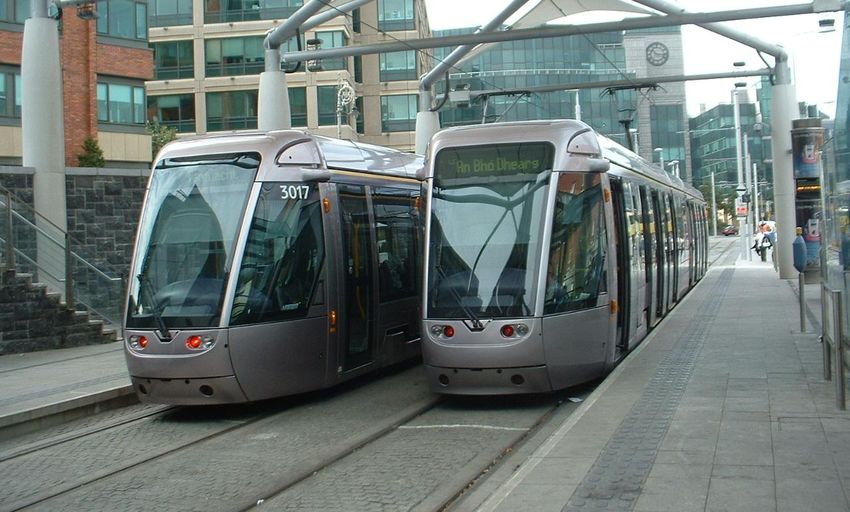
SHD Development at Cooldown Commons Phase 3                                                                             2
Mobility Management Plan

Document Control

Job Title:                     SHD Development at Cooldown Commons Phase 3

Job Number:                    p190003

Report Ref:                    190003-DBFL-TR-XX-RP-C-1002

Author:                        Daniel Gill

Reviewed by:                   Mark McKenna

Date:                          May 2021

Distribution:                  Clients Design Team
                               DBFL Consulting Engineers
                               Planning Authority
  Revision         Issue Date                 Description                 Prepared          Reviewed          Approved
       1           06/11/2020                      Draft                      DG               MMK                  -
       2           11/12/2020                  Final Draft                    DG               MMK                  -
       3           16/12/2020                      Final                      DG               MMK               MMK
       4           23/04/2021                  Draft Rev A                    DG               MMK               MMK
       5           25/05/2021              Rev B (Final Draft)                DG               MMK               MMK
       6           26/05/2021                 Rev C (Final)                   DG               MMK               MMK
       7           10/06/2021                 Rev D (Final)                   DG               MMK               MMK

 DBFL Consulting Engineers
 Dublin Office                             Waterford Office                         Cork Office
 Ormond House                              Suite 8b The Atrium                      14 South Mall,
 Upper Ormond Quay                         Maritana Gate,                           Cork.
 Dublin 7.                                 Canada Street, Waterford.

 Tel       01 4004000                      Tel       051 309500                     Tel       021 2024538
 Email     info@dbfl.ie                    Email     info@dbfl.ie                   Email     info@dbfl.ie
 Web       www.dbfl.ie                     Web       www.dbfl.ie                    Web       www.dbfl.ie

This document has been prepared for the exclusive use of our Client and unless otherwise agreed in writing with DBFL
Consulting Engineers, no other party may use, make use of, or rely on the contents of this document. The document has
been compiled using the resources agreed with the Client, and in accordance with the agreed scope of work. DBFL
Consulting Engineers accepts no responsibility or liability for any use that is made of this document other than for the
purposes for which it was originally commissioned and prepared, including by any third party, or use by others, of opinions
or data contained in this document. DBFL Consulting Engineers accepts no liability for any documents or information supplied
by others contained or referenced in this document. It is expressly stated that no independent verification of any documents
or information supplied by others for this document has been made. DBFL Consulting Engineers has used reasonable skill,
care, and diligence in compiling this document. It should be noted that no changes of whatsoever nature are to be made
to any wording, information or details set out or contained in any DBFL document unless the express consent has been
obtained in advance, in writing, from DBFL.

DBFL Consulting Engineers                                                                                    p190003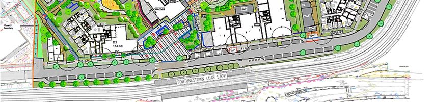
SHD Development at Cooldown Commons Phase 3                                                                              3
Mobility Management Plan

                                                  CONTENTS

1.0     INTRODUCTION..................................................................................... 6
  1.1      CONTEXT .......................................................................................................6
  1.2      BACKGROUND ................................................................................................. 7
  1.3      STRUCTURE OF REPORT ..................................................................................8

2.0     MOBILITY MANAGEMENT PLAN FRAMEWORK .............................. 10
  2.1      WHAT IS A MOBILITY MANAGEMENT PLAN? .................................................... 10
  2.2      WHAT IS A RESIDENTIAL MOBILITY MANAGEMENT PLAN? ................................ 10
  2.3      WHO IS INVOLVED? ...................................................................................... 11
  2.4      OBJECTIVES OF A MOBILITY MANAGEMENT PLAN ............................................ 12
  2.5      MOBILITY MANAGEMENT PLAN PROCESS ........................................................ 12
  2.6      MOBILITY MANAGEMENT PLAN NEXT STEP ...................................................... 14
  2.7      POLICY FRAMEWORK ..................................................................................... 15

3.0     RECEIVING ENVIRONMENT & PROPOSED DEVELOPMENT .......... 23
  3.1      LAND USE..................................................................................................... 23
  3.2      LOCATION .................................................................................................... 23
  3.3      EXISTING TRANSPORTATION INFRASTRUCTURE .............................................. 25
  3.4      LOCAL AMENITIES......................................................................................... 31
  3.5      PROPOSED TRANSPORT INFRASTRUCTURE ..................................................... 31
  3.6      PROPOSED DEVELOPMENT ............................................................................. 36

4.0     COMMUTER TRENDS & TRANSPORT NEEDS ................................. 45
  4.1      INTRODUCTION ............................................................................................ 45
  4.2      SUBJECT SITE PROPOSED MODAL SPLIT ......................................................... 48

5.0     OBJECTIVES & TARGETS .................................................................. 50
  5.1      INTRODUCTION ............................................................................................ 50
  5.2      MMP OBJECTIVES.......................................................................................... 50
  5.3      MMP ACTIONS & TARGETS ............................................................................. 51

6.0     MMP MEASURES ................................................................................ 55
  6.1      INTRODUCTION ............................................................................................ 55
  6.2      MODE SPECIFIC MEASURES............................................................................ 56
  6.3      MANAGEMENT & MONITORING MEASURES ...................................................... 56
  6.4      MARKETING & PROMOTION MEASURES........................................................... 57

7.0     PRELIMINARY ACTION PLAN ............................................................ 60

DBFL Consulting Engineers                                                                                       p190003
SHD Development at Cooldown Commons Phase 3                                                                            4
Mobility Management Plan

  7.1     OVERVIEW ................................................................................................... 60
  7.2     MANAGEMENT AND MONITORING STRATEGY .................................................. 60
  7.3     WALKING STRATEGY ..................................................................................... 64
  7.4     CYCLING STRATEGY ...................................................................................... 66
  7.5     PUBLIC TRANSPORT STRATEGY ...................................................................... 68
  7.6     PRIVATE CAR STRATEGY................................................................................ 70
  7.7     MARKETING AND PROMOTION STRATEGY ....................................................... 72

8.0     SUMMARY AND CONCLUSIONS ....................................................... 75
  8.1     SUMMARY..................................................................................................... 75

                                               APPENDICES

Appendix A                   Purpose of Trip, based on Trend Modes in Greater Dublin Area

Appendix B                   Trends in Travel by Modes at Existing Residential Developments
                             in the Citywest & Saggart Areas

DBFL Consulting Engineers                                                                                     p190003
SHD Development at Cooldown Commons Phase 3                             5
Mobility Management Plan

                                                          CHAPTER 1

                                                        Introduction

                                              1.1   CONTEXT
                                              1.2   BACKGROUND
                                              1.3   STRUCTURE OF REPORT

DBFL Consulting Engineers                                          p190003
SHD Development at Cooldown Commons Phase 3                                             6
Mobility Management Plan

1.0 INTRODUCTION
1.1     CONTEXT

1.1.1 DBFL Consulting Engineers (DBFL) has been commissioned by Cairn Homes
        Properties Ltd. to compile a Traffic and Transport Assessment (TTA) for a
        proposed development will consist of the construction of 421 no. residential
        units within 9 no. blocks ranging in height from 1 – 13 storeys,
        retail/commercial/office units, residential amenity space, and open spaces
        along with all associated site development works and services provisions to
        facilitate the development including parking, bin storage, substations,
        landscaping and all services.

1.1.2 This MMP should be read in conjunction with the accompanying Traffic and
        Transportation Assessment (TTA) Report. The MMP has been prepared to guide
        the delivery and management of several coordinated initiatives which ultimately
        seek to encourage sustainable travel practices for all journeys to and from the
        proposed development.

1.1.3 This framework document aims to inform two distinct audiences as follows;

               The appointed Mobility Manager who will be responsible for
               implementing and managing the MMP. Should the manager not be overly
               familiar with the MMP process they will find the process and context
               information as outlined in Chapter 2 invaluable. The preliminary MMP
               targets and measures introduced in Chapter 5 and Chapter 6 will be
               coordinated, administered and updated by the appointed Mobility
               Manager.
               The Local Authority Officers who will be eager to ensure that the MMP
               initiatives are appropriately ambitious, deliverable and implemented fully.
               The officers, who will be very familiar with the MMP process, will be
               predominately interested in the proposed MMP Targets (Chapter 5) and
               associated measures (Chapter 6).
               The eventual Residents and Staff based within the proposed
               development who may not have a full understanding of the MMP process
               and objectives. Accordingly, the process and context information as
               outlined in Chapter 2 will assist them in gaining an understanding of
               MMPs.

DBFL Consulting Engineers                                                         p190003
SHD Development at Cooldown Commons Phase 3                                             7
Mobility Management Plan

1.2     BACKGROUND

1.2.1 This Mobility Management Plan (MMP) has been prepared to guide the delivery
        and management of a package of integrated initiatives which seek to encourage
        sustainable travel practises at the proposed residential development located at
        Citywest, Dublin 24. This document aims to expand the awareness of and
        increase travel options for both the residents, visitors and staff located at the
        site. The Plan will be used mainly by the appointed Mobility Manager who will
        be responsible for implementing and managing the MMP for the benefits of the
        residents, visitors and staff who may be interested in reading this document to
        see how it directly affects them.

1.2.2 This Framework MMP has been prepared to guide the delivery and
        management of a package of integrated initiatives which ultimately seek to
        encourage sustainable travel practices of all residents, visitors and staff
        travelling to/from the proposed development at Cooldown Commons.

1.2.3 The purpose of the Mobility Management Plan is to:

               Provide a ‘manual’ and record for the Mobility Manager who will be
               appointed to oversee the implementation and development of the
               measures set out in the document,

               A formal record for the local authority in regard to the type, scale and
               number of initiatives that the MMP initially proposes and subsequently
               their level of success in subsequent versions of the MMP which remains
               a ‘live’ document to be updated at least initially every 2 to 3 years
               following its implementation, and

               The MMP will seek to provide a long-term strategy for encouraging
               residents, staff and visitors to reduce their dependency on travelling by
               car in favour of more sustainable modes of travel.

1.2.4 The aims of the strategy are:

          (a) to increase the awareness of residents, staff and visitors to all the
               transport options available to them and to the potential for travel by more
               sustainable modes, and

DBFL Consulting Engineers                                                         p190003
SHD Development at Cooldown Commons Phase 3                                             8
Mobility Management Plan

          (b) to introduce a package of both ‘hard’ (physical) and ‘soft’ (behavioural)
               measures that will facilitate travel by sustainable modes of travel to/from
               the subject development.

1.3     STRUCTURE OF REPORT

1.3.1 Following this introduction, the MMP framework including the definition of a
        MMP, its objectives, the scope and process involved in compiling and
        implementing such a plan is outlined in Chapter 2.

1.3.2 The environment within which the proposed development MMP is placed and
        an overview of the scheme proposals is briefly outlined in Chapter 3.

1.3.3 The MMP context in terms of existing local travel trends is established in
        Chapter 4.

1.3.4 The MMP objectives and adopted targets are established in Chapter 5.

1.3.5 In Chapter 6 the measures and travel initiatives selected to encourage
        sustainable travel are discussed. These include Mode Specific Measures,
        Management Measures, Marketing Measures and Monitoring & Review
        Measures.

1.3.6 With the objective of establishing the basis for discussions with key
        stakeholders including the local authority, from which an agreed MMP action
        plan can be adopted, Chapter 7 presents a Preliminary Action Plan for the
        development at the subject site.

1.3.7 The main conclusions and recommendations of the MMP are summarised in
        Chapter 8.

DBFL Consulting Engineers                                                         p190003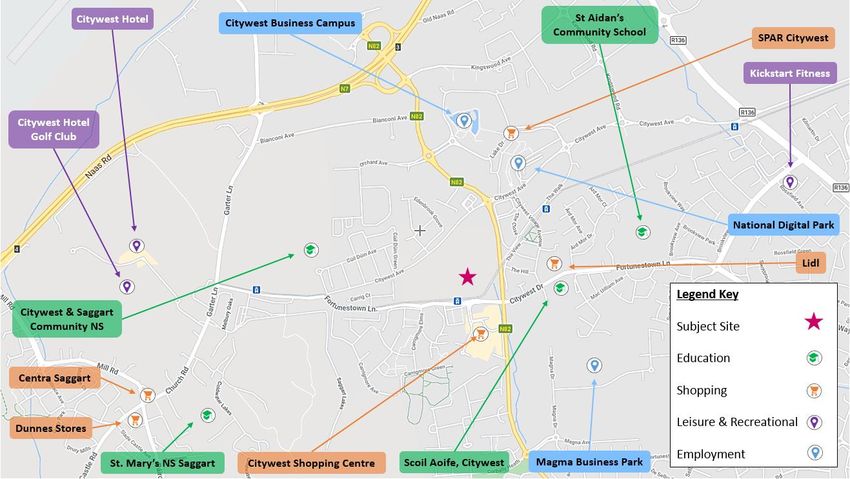
SHD Development at Cooldown Commons Phase 3                     9
Mobility Management Plan

                                                   CHAPTER 2
                                              Mobility Management
                                                   Plan Framework

                         2.1 WHAT IS A MOBILITY MANAGEMENT PLAN?
                         2.2 WHAT IS A DESTINATION MMP?
                         2.3 WHO IS INVOLVED?
                         2.4 OBJECTIVES OF A MMP
                         2.5 MMP PROCESS
                         2.6 MMP NEXT STEP
                         2.7 POLICY FRAMEWORK

DBFL Consulting Engineers                                  p190003
SHD Development at Cooldown Commons Phase 3                                            10
Mobility Management Plan

2.0 MOBILITY MANAGEMENT PLAN FRAMEWORK
2.1     WHAT IS A MOBILITY MANAGEMENT PLAN?

2.1.1 The Dublin Transportation Office’s (which has been subsumed into the National
        Transportation Authority (NTA) in December 2009) 2001 publication entitled
        “The Route to Sustainable Commuting” defines a MMP as “… a package of
        measures put in place by an organisation to encourage and support more
        sustainable travel patterns …”.

2.1.2 The MMP can be developed for an individual site or group of sites and designed
        specially to respond to a range of different site-specific land uses such as
        business (offices, retail, industrial etc.), residential and schools/ colleges/
        universities.

2.1.3 Whilst the emergence and successful application of residential MMP’s has only
        transpired over the last decade in Ireland, other countries have extensive
        experience in designing, implementing, marketing and monitoring the
        successful delivery of MMP’s. Accordingly, MMP’s are also known by a number
        of other names including;

                  Travel Plans,
                  Green Travel Plans,
                  Sustainable Mobility Plans, or
                  Sustainable Commuter Plans.

2.2     WHAT IS A RESIDENTIAL MOBILITY MANAGEMENT PLAN?

2.2.1 Residential Mobility Management Plan is a package of measures designed to
        reduce the number and length of car trips generated by a residential
        development, while also encouraging more sustainable forms of travel and
        reducing the overall need to travel. It sets out objectives and targets to achieve
        sustainable travel patterns.

2.2.2 A successfully implemented Residential MMP can provide reductions in car
        usage, particularly influencing levels of single-occupancy car travel, with
        increased trips made by public transport, walking and cycling; and improve
        road safety and personal security (especially for pedestrians and cyclists).

DBFL Consulting Engineers                                                         p190003
SHD Development at Cooldown Commons Phase 3 11
Mobility Management Plan
2.2.3 Mobility Management Plans to date have mainly focussed on the development
of destination MMP’s and to encourage travel by sustainable modes for
employment and school developments. Destination MMP’s focus on a
particular journey purpose while a residential MMP is concerned with journeys
made from a single origin (home) to multiple and changing destinations.
2.2.4 Best Practise guidance is provided in “Making Residential Travel Plans Work –
Good Practice Guidelines For New Development” published by the Department
for Transport (UK) in September 2005 and “Making Residential Travel Plans
Work” in August 2007. These documents highlight that a Residential MMP will
be different to a school or workplace MMP as the pattern of journeys
originating at home is more varied with multiple destinations and different
needs and travel choices.
2.2.5 The DfT’s (UK) “Making Residential Travel Plans Work – Good Practice
Guidelines” suggest that the growing interest in residential travel planning is
being driven by two factors:
“the increased acceptance of travel planning as a legitimate part of
the transport planning toolkit and an effective mechanism in helping
both to reduce congestion and to promote the use of sustainable
modes of transport”
“the pressure for new housing and its transport implications in many
parts of the country is driving the need to find new ways of ensuring
the development of more sustainable communities”.
2.3 WHO IS INVOLVED?
2.3.1 A MMP impacts the following key stakeholders who should all be involved in
some form or manner in the process:
Local Authority Officers,
Housing developers,
Future residents at sites that have a MMP,
Residents in the community surrounding new housing developments
with a MMP, and
Transport Operators
DBFL Consulting Engineers p190003SHD Development at Cooldown Commons Phase 3 12
Mobility Management Plan
2.4 OBJECTIVES OF A MOBILITY MANAGEMENT PLAN
2.4.1 The principal objective of an MMP is to reduce levels of private car use by
encouraging people to walk, cycle, use public transport, car share or even
reduce the number and length of trips undertaken / required.
2.4.2 A comprehensive range of goals, and subsequent complementary secondary
level objectives, can be identified with the purpose of achieving the ultimate
objective of the MMP. This can be achieved through the delivery of a range of
complimentary integrated initiatives which can positively influence travel
behaviour and associated travel habits.
2.4.3 The specific objective(s) of an MMP can vary depending upon the organisation,
site characteristics and specific land uses which vary with each site.
Nevertheless, in the context of this MMP objectives can include;
a) For the Residents –
Address residents’ need for access to a full range of facilities for
work, education, health, leisure, recreation and shopping,
Promote healthy lifestyles and sustainable, vibrant local
communities.
b) For Staff and Employees –
Promote healthy lifestyles and sustainable modes of travel to
work; and
Increase attractiveness and availability of active transport routes,
c) The Local Community –
Reduce the traffic generated by the development for journeys
both within the development and on the external road network,
Make local streets less dangerous, less noisy and less polluted,
Enhance viability of public transport,
Improve the environment and the routes available for cycling and
walking.
2.5 MOBILITY MANAGEMENT PLAN PROCESS
2.5.1 Once the decision has been made to produce a MMP the process of compiling
DBFL Consulting Engineers p190003SHD Development at Cooldown Commons Phase 3 13
Mobility Management Plan
the plan encompasses the 9 principal steps presented in Graph 2.1 below.
2.5.2 The MMP however remains an ‘active’ document which continues to evolve and
develop during its lifecycle. Accordingly, once the initial nine steps have been
successfully completed (including monitoring and reporting requirements), the
process recommences with the identification of new actions and associated
targets which instigates the second generation of the MMP. As a result,
subsequent generations of the MMP can be incorporated into the management
and operation of the subject development for as long as necessary or
potentially even for the entire existence of the development.
(1) Identify
Team,
Consult &
Survey
(9) Update &
(2) Collate &
Publish New
Analyse Info
Action Plan
COMPLETED
/ ON-GOING
(3) Identify
(8) Identify
Objectives &
New Targets
Mobility Targets
Management
Plan (MMP)
PROPOSED Process
IMMINENT
(7) Celebrate (4) Develop
Success Action Plan
(6) Monitor & (5) Publish &
Review Launch MMP
Graph 2.1: MMP Development Process and Status
2.5.3 Once the development’s specific objectives are identified “SMART” targets will
both assist in defining the specific measures that are included and / or
prioritised within the MMP (to reach the objective) and help with the monitoring
DBFL Consulting Engineers p190003SHD Development at Cooldown Commons Phase 3 14
Mobility Management Plan
and evaluation of the level of success achieved by the MMP. SMART targets,
which can be agreed with the local authority should be;
2.6 MOBILITY MANAGEMENT PLAN NEXT STEP
2.6.1 In the context of the development’s operational framework, the local receiving
environment and the identification of the Preliminary Action Plan this document
should form the basis by which;
(a) the subject Cooldown Commons Phase 3 residential development’s
specific travel characteristics are outlined and presented to the local
authority, and
(b) the businesses (occupying the retail/commercial/office) and their
staffs specific travel characteristics are established and presented
to the local authority, and
(c) through a partnership approach between the developers and the
local planning authority, the Preliminary Action Plan is explored and
re-examined with the objective reaching agreement upon the MMP’s
measures and subsequently the adoption of an ‘agreed’ MMP Action
DBFL Consulting Engineers p190003SHD Development at Cooldown Commons Phase 3 15
Mobility Management Plan
Plan with targets, initiatives, timescales, responsibilities and
resources clearly outlined and approved by both parties.
2.6.2 To enable this process to commence it is proposed that this MMP framework
document, as compiled by DBFL, this report will be submitted to South Dublin
County Council. At the request of the local authority, a meeting between the
local authority officers and the developers can take place if required with the
objective of formally agreeing a MMP action plan and associated targets for the
subject development as proposed at Citywest.
2.7 POLICY FRAMEWORK
2.7.1 The MMP for the Cooldown Commons Phase 3 is supported by comprehensive
transport policy hierarchy in addition to being influenced directly / indirectly by
other policy themes (e.g. environmental, health etc.) which generate a range
of complementary policy instruments in addition to demands and pressures that
clearly necessitate a change in existing travel behaviour. Commencing at EU
level and subsequently transferred into national policy and regulations in
Ireland the hierarchy continues from regional (Greater Dublin Area) to sub-
region (South Dublin County) through area eventually arriving at site (or land
use) specific policy objectives.
Greater Dublin Area
Transport Strategy
2011-30
South Dublin
County Council
Mobility Strategy
Fortunestown
LAP
Destination
Health Environmental
MMP
Policy Policy
Figure 2.1: Cooldown Commons Phase 3 MMP Policy Framework and External
Influences
DBFL Consulting Engineers p190003SHD Development at Cooldown Commons Phase 3 16
Mobility Management Plan
National Smarter Travel Policy
2.7.2 Smarter Travel A Sustainable Transport
Future, was published in February 2009, and
represents a new transport policy for Ireland
for the period 2009-2020. The policy
recognises the vital importance of continued
investment in transport to ensure an efficient
economy and continued social development,
but it also sets out the necessary steps to
ensure that people choose more sustainable
transport modes such as walking, cycling and
public transport.
2.7.3 The policy is a direct response to the fact that
continued growth in demand for road transport is not sustainable due to the
resulting adverse impacts of increasing congestion levels, local air pollution,
contribution to global warming, and the additional negative impacts to health
through promoting increasingly sedentary lifestyles.
2.7.4 The following five key goals form the basis of the Smarter Travel policy
document.
Improve quality of life and accessibility to transport for all and, in
particular, for people with reduced mobility and those who may
experience isolation due to lack of transport.
Improve economic competitiveness through maximising the efficiency of
the transport system and alleviating congestion and infrastructural
bottlenecks.
Minimise the negative impacts of transport on the local and global
environment through reducing localised air pollutants and greenhouse
gas emissions.
Reduce overall travel demand and commuting distances travelled by the
private car.
Improve security of energy supply by reducing dependency on imported
fossil fuels.
DBFL Consulting Engineers p190003SHD Development at Cooldown Commons Phase 3 17
Mobility Management Plan
2.7.5 These aims will be achieved through 49 specific actions, which can be broadly
grouped into 4 key areas:
Actions to reduce distance travelled by private car and encourage smarter
travel,
Actions aimed at ensuring that alternatives to the private car are more
widely available,
Actions aimed at improving the fuel efficiency of motorised transport
through improved fleet structure, energy efficient driving and alternative
technologies, and
Actions aimed at strengthening institutional arrangements.
2.7.6 The opportunities and potential benefits that could be achieved by the
implementation of a MMP are considered under the policy goal of encouraging
Smarter Travel.
2.7.7 The Smarter Travel policy also includes for a comprehensive range of
supporting ‘actions’ including mode specific (e.g. walking, cycling and public
transport etc.) and behaviour change initiatives which both encourage and
provide for sustainable travel practices for all journeys.
DBFL Consulting Engineers p190003SHD Development at Cooldown Commons Phase 3 18
Mobility Management Plan
Transport Strategy for the Greater Dublin
Area 2016-2035
2.7.8 The Transport Strategy for the Greater Dublin
Area 2016-2035 is a document compiled by the
National Transport Authority which sets out “a
framework for the planning and delivery of
transport infrastructure and services in the
Greater Dublin Area (GDA)” up to 2035.
2.7.9 The purpose of the strategy is “To contribute to
the economic, social and cultural progress of the
Greater Dublin Area by providing for the efficient,
effective and sustainable movement of people and goods”.
South Dublin County Development Plan 2016 - 2022
2.7.10 The South Dublin County Development Plan 2010-2016 sets the broad
development framework for the county and the development areas within its
administrative boundary. In the context of the subject proposals, the following
are the relevant transport and development objectives set out in the plan:
Housing Policy
“Policy 6 – Sustainable Communities: It is the policy of the Council to
support the development of sustainable communities and to ensure that new
housing development is carried out in accordance with Government policy in
relation to the development of housing and residential communities.”
Housing Objective
“H2 Objective 1: To ensure that sufficient zoned land, which could be
serviced by sufficient public transport and road capacity, continues to be
available at appropriate locations to satisfy the housing requirements of the
County and to support and facilitate the development of housing lands based
on the Settlement Strategy outlined in Chapter 1 Introduction and Core
Strategy.”
Transport & Mobility Policies
DBFL Consulting Engineers p190003SHD Development at Cooldown Commons Phase 3 19
Mobility Management Plan
“Policy 1 – Overarching: It is the policy of the Council to promote the
sustainable development of the County through the creation of an integrated
transport network that services the needs of communities and businesses.”
“Policy 2 – Public Transport: It is the policy of the Council to promote the
sustainable development of the County by supporting and guiding national
agencies in delivering major improvements to the public transport network
and to ensure existing and planned public transport services provide an
attractive and convenient alternative to the car.”
“Policy 3 – Walking and Cycling: It is the policy of the Council to re-
balance movement priorities towards more sustainable modes of
transportation by prioritising the development of walking and cycling facilities
within a safe and traffic calmed street environment.”
“Policy 4 – Strategic Road and Street Network: It is the policy of the
Council to improve and expand the County-wide strategic road and street
network to support economic development and provide access to new
communities and development.”
Transport & Mobility Objectives
“TM1 Objective 4: To prioritise new road construction that provides access
to new communities and development areas and supports the economic
development of the County.”
“TM1 Objective 4: To support the delivery of sufficient public transport and
road capacity to facilitate sustainable new development in the County.”
“TM2 Objective 3: To generate additional demand for public transport
services through integrated land use planning and maximising access to
existing and planned public transport services throughout the network.”
“TM2 Objective 4: To create an interlinked network that maximises the
efficiency of existing services, reduces overall journey times and facilitates
easy exchanges between modes and/or routes.”
“TM3 Objective 2: To ensure that connectivity for pedestrians and cyclists
is maximised in new communities and improved within existing areas in order
to maximise access to local shops, schools, public transport services and other
DBFL Consulting Engineers p190003SHD Development at Cooldown Commons Phase 3 20
Mobility Management Plan
amenities, while seeking to minimise opportunities for anti-social behaviour
and respecting the wishes of local communities.”
Fortunestown Local Area Plan May 2012
2.7.11 The subject site lies within the Fortunestown Local Area Plan lands (Figure
2.2) and as such is governed by the specific policies and objectives outlined
with the Fortunestown Local Area Plan (2012). In the context of the subject
proposals, the following are the relevant transport and development objectives
set out in the plan:
Subject Site
FIGURE 2.2: Fortunestown LAP Area (Extract of Fig 1.1 Fortunestown LAP 2012)
Local Area Plan Objective AM1
“That future development will be mainly focused around the four Luas stops,
especially the Fortunestown Stop at the District Centre and will create or
facilitate direct routes to these stops.”
Local Area Plan Objective AM2
“That all planning applications for residential and employment development
are required to provide or integrate with direct, safe and attractive pedestrian
and cyclist routes to public transport stops.”
Local Area Plan Objective AM3
DBFL Consulting Engineers p190003SHD Development at Cooldown Commons Phase 3 21
Mobility Management Plan
“Encourage cycling within and through the Plan Lands by creating an open
ended and integrated network of safe and accessible cycle routes that serve
primary, secondary and tertiary streets and spaces. Cycle paths that
correspond with vehicular routes shall be provided on-street on both sides
and shall be separated from pedestrian routes.”
Local Area Plan Objective AM6
“That pedestrian routes are provided on both sides of every street and
through every public space in a manner that creates direct and indirect links
with nodal points, civic uses, public open spaces and with the District Centre.”
Local Area Plan Objective AM7
“To create a network of pedestrian routes between destinations including
housing, business parks, employment areas and public transport stops and to
make walking, cycling and the use of public transport a priority.”
Local Area Plan Objective AM9
“To ensure that development within the Plan Lands is based on a grid layout .”
Local Area Plan Objective AM12
“That movement corridors within new developments are based on a grid
format that avails of every possibility to link into the existing street network
and provide efficient connections to existing local facilities. The grid shall align
with desire lines and link sites to specific destinations. Footpaths shall be
provided on either side of every street and shall be direct, safe, barrier free
and overlooked by development.”
DBFL Consulting Engineers p190003SHD Development at Cooldown Commons Phase 3 22
Mobility Management Plan
CHAPTER 3
Receiving Environment &
Proposed Development
3.1 LAND USE
3.2 LOCATION
3.3 EXISTING TRANSPORT INFRASTRUCTURE
3.4 LOCAL AMENITIES
3.5 PROPOSED TRANSPORT INFRASTRUCTURE
3.6 PROPOSED DEVELOPMENT
DBFL Consulting Engineers p190003SHD Development at Cooldown Commons Phase 3 23
Mobility Management Plan
3.0 RECEIVING ENVIRONMENT & PROPOSED
DEVELOPMENT
3.1 LAND USE
3.1.1 The subject lands are zoned “Objective RES-N – To provide for new residential
communities in accordance with approved area plans” within the South Dublin
County Development Plan 2016-2022.
FIGURE 3.1: SDCC Land Use Zoning (Extract of Map 8 SDCC Development Plan 2016-
2022)
3.1.2 The surrounding area predominantly consists of a mix of residential
developments, residentially zoned lands and business parks. A number of the
Citywest Business Campus units are located to the north and northeast of the
subject site. The permitted Cooldown Commons Phase 2 development lands
(Pl. Ref. ABP302398) are situated immediately to the west of the subject
development site (a section of which is proposed to be amended as part of the
subject proposals) whilst the permitted development Pl. Ref. SD16A/0210 lands
are situated immediately to the northwest of the subject development site.
3.2 LOCATION
3.2.1 The general location of the subject site in relation to the surrounding road
network is illustrated in Figure 3.2 below whilst Figure 3.3 indicatively shows
DBFL Consulting Engineers p190003SHD Development at Cooldown Commons Phase 3 24
Mobility Management Plan
the extent of the subject site boundary and neighbouring lands. The subject
Citywest site is located approximately 6.6km west of Tallaght and 14.8km
southwest of Dublin City Centre.
Luas Red Line
N7
N82
N7 Fortunestown Lane
Subject Site
N82
Boherboy Road
N81
N81
FIGURE 3.2: Site Location (Source Google Maps)
Pl. Ref.
Pl. Ref.
ABP302398
SD16A/0210
Indicative Site
Boundary
Pl. Ref.
ABP302398
LUAS Red Line
FIGURE 3.3: Site Boundary (Source Google Maps)
3.2.2 The development site is bounded to the south by the Fortunestown Lane
corridor and LUAS Red Line whilst the north / eastern boundaries comprise
undeveloped (permitted development) residentially zoned lands. The western
boundary comprises a residential development (Pl. Ref. ABP302398) which is
currently under construction.
DBFL Consulting Engineers p190003SHD Development at Cooldown Commons Phase 3 25
Mobility Management Plan
3.3 EXISTING TRANSPORTATION INFRASTRUCTURE
Road Network
3.3.1 To the north of the subject site, the Citywest Avenue Extension corridor runs
in an East-West direction. The central section of this corridor has recently been
constructed as part of the adjacent development site (Pl. Ref. ABP302398)
which provide a through route between the N82 Citywest Road corridor to the
east and the Fortunestown Lane corridor to the west. Travelling in a westerly
direction on Citywest Avenue leads to the Fortunestown Lane / Citywest Avenue
signal controlled junction and subsequently the Fortunestown Lane / Garter
Lane signal controlled junction. To the north Garter Lane provides a direct route
to the N7 southbound carriageway, whilst to the south Garter Lane / Church
Road leads to the village of Saggart, located approximately 1.5km away.
3.3.2 Travelling eastbound on Citywest Avenue Extension from the subject site leads
to a four-arm roundabout junction with the N82 Citywest Road. Travelling
southbound from this roundabout junction, Citywest Road terminates at a
three-arm junction with N81 Blessington Road providing access to Blessington
(located approx. 17km to the south west) and Tallaght (located approx. 5km
to the north east).
3.3.3 Travelling north on the N82 Citywest Road provides access to the N7
northbound and southbound carriageways via Junction 3. The N7 provides
convenient access to destinations including Rathcoole, Naas and Kildare to the
southwest (as well the strategic M7, M8 & M9 motorways). The strategic M50
motorway (northbound and southbound) is accessible via the M50 Junction 9
located approximately 6km to the northeast whilst Dublin City Centre is
accessible via the Naas Road corridor and is located approx. 16km away.
Existing Cycling and Pedestrian Facilities
3.3.4 The recently constructed section of Citywest Avenue in the vicinity of the
subject site benefits from dedicated verge segregated pedestrian / cycle
facilities on both sides of the corridor as presented in Figure 3.4 below. The
cycle and pedestrian facilities are differentiated by surface type and provided
at the same level.
DBFL Consulting Engineers p190003SHD Development at Cooldown Commons Phase 3 26
Mobility Management Plan
FIGURE 3.4: Citywest Avenue Cycle / Pedestrian Facilities
3.3.5 Fortunestown Lane currently benefits from a footway and cycle track on the
southern side of the corridor (Figure 3.5). Currently pedestrian only facilities
are in place on the northern side of this corridor
FIGURE 3.5: Pedestrian & Cycle Facilities on Fortunestown Lane
3.3.6 The Citywest Road corridor benefits from verge segregated footways on both
sides of the road carriageway in addition to street lighting.
FIGURE 3.6: Pedestrian Facilities on N82 Citywest Road
3.3.7 The Greater Dublin Area Cycle Network Plan details the GDA’s existing and
proposed Cycle Network incorporating Urban, Inter-urban and Greenroute
networks. The subject site is located within the sector designated as the “Dublin
South West”. Figure 3.7 illustrates the existing cycle infrastructure in the
vicinity of the subject site at the time the Plan was published in December 2013.
DBFL Consulting Engineers p190003SHD Development at Cooldown Commons Phase 3 27
Mobility Management Plan
FIGURE 3.7: GDA Cycle Network Plan Existing Cycle Facilities (Extract of Sheet E6)
Public Transport – Bus
3.3.8 The subject site benefits from excellent public transport accessibility levels
including both light rail and bus-based services. Dublin Bus operates three
routes that serve the subject site locale including the number 69 (Fleet Street
– Rathcoole), the number 65b (Citywest – Poolbeg Street) and the number 77a
(Citywest – Ringsend Road). All three routes provide links from the subject
site’s general vicinity to the city centre via alternative routes thereby serving
different catchment areas between Citywest and the City Centre including
Clondalkin (Route 69), Terenure (Route 65b) and Firhouse (Route 77a).
3.3.9 There is also a route number 77x which provides a daily weekday service from
Citywest to UCD Belfield from Mondays to Fridays only. Go-Ahead Bus route
175 is also easily accessible from the subject site which operates between
Sundays & Bank
Weekdays Saturdays
Holidays
Bus
Route To City From City To City From City To City From City
Centre Centre Centre Centre Centre Centre
DB 65b 18 20 17 19 15 15
DB 69 24 17 24 17 10 10
DB 77a 56 52 46 46 32 34
DB 77x 1 service - - - - -
GA 175 34 35 17 16 16 15
DB = Dublin Bus, GA = Go-Ahead Bus
TABLE 3.1: Bus Service Frequency (No. of Services per Day)
3.3.10 The local Bus stops are all within walking distance of the subject site are
illustrated in Figure 3.8 below
DBFL Consulting Engineers p190003SHD Development at Cooldown Commons Phase 3 28
Mobility Management Plan
FIGURE 3.8: Bus Stop Locations
3.3.11 In addition, Dualway Transport provides a daily service (Route 311) from
Newcastle/Rathcoole to The Square, Tallaght from Mondays to Fridays only,
with the exception of Wednesdays when there are 2 services.
FIGURE 3.9: Existing Bus Network (Extract from Map 1 Bus Connects
Dublin Bus Network Redesign)
Public Transport – LUAS Services
3.3.12 The subject site is conveniently located to benefit from LUAS Red Line services.
The ‘Fortunestown’ interchange is located within a short convenient walking
distance and is located adjacent to the south eastern section of the subject
site. A pedestrian connection is proposed between the subject site and the
Fortunestown Luas interchange as presented in Figure 3.10 below.
DBFL Consulting Engineers p190003SHD Development at Cooldown Commons Phase 3 29
Mobility Management Plan
3.3.13 The Red Line currently operates between Saggart / Tallaght and The Point. At
the Belgard interchange, the LUAS Red line branches in two directions; to
Saggart and to Tallaght.
3.3.14 Table 3.2 below lists the frequency with which the Fortunestown LUAS service
operates.
Subject Site
Pedestrian link to Luas interchange Fortunestown Luas
Stop
Adjacent to the
subject site
FIGURE 3.10: LUAS Interchange in the Vicinity of the Subject Site
Weekdays Saturdays Sundays & Bank Holidays
Link
Peak Off-Peak Peak Off-Peak Peak Off-Peak
Saggart – Belgard 9-10 10-15 12 12-15 10-12 12-15
Belgard – Busáras 3-5 6-15 6-7 6-15 10-11 10-15
Busáras – The Point 4-10 10-15 12 12-15 10-12 11-15
TABLE 3.2: LUAS Service Frequency (In minutes)
DBFL Consulting Engineers p190003SHD Development at Cooldown Commons Phase 3 30
Mobility Management Plan
Bus Eireann Route 130
Bus Eireann Route 126
Dublin Bus Route 27
Bus Eireann Route 124
800m Catchment Area
Luas Red Line
Dublin Bus Route 69
Go Ahead Route 175
Subject Site
Dublin Bus Route 65
Dublin Bus Route 65B Dublin Bus Route 77X
Dublin Bus Route 77A
Route 65B, 77A, 77X
Bus Stop, (Southbound)
Luas Red Line Services Approx. 580m From Site
Approx. 50m From Site Access
Shared Bus Stop
Fortunestown Luas Stop
Route 175 Bus Stop,
Approx. 175m From Site
Go Ahead Bus Stop
Route 65B, 77A, 77X
Bus Stop, (Northbound)
Approx. 200m From Site
Route 65B, 77A, 77X
Bus Stop, (Northbound)
Shared Bus Stop
Approx. 200m From Site
Shared Bus Stop
FIGURE 3.11: Public Transport Linkages
DBFL Consulting Engineers p190003SHD Development at Cooldown Commons Phase 3 31
Mobility Management Plan
3.4 LOCAL AMENITIES
3.4.1 As illustrated in Figure 3.12, the proposed development site is well placed in
terms of the availability of and access to local amenities. There are a number
of primary and post primary schools within 2km of the subject site. These
include Scoil Aoife, St. Mary's National School Saggart, Citywest & Saggart
Community National School and St Aidan’s Community School.
3.4.2 The subject site also benefits from good access to local retail and leisure
facilities. Lidl and Citywest Shopping Centre are both within 5 minutes walking
distance from the subject site. Additionally, Centra Saggart and Dunnes Stores
are approx. 1.7km to the south-west of the site. Citywest Hotel & Golf Club are
located to the west of the site and can be accessed via Church Road.
3.4.3 Furthermore, the subject development site is well places to benefit from local
employment opportunities at Citywest Business Campus and the National
Digital Park both located to the north and Magna Business Park located in the
south.
FIGURE 3.12: Local Amenities
3.5 PROPOSED TRANSPORT INFRASTRUCTURE
Cycle Network Proposals
3.5.1 In December 2013, the NTA published the report entitled ‘Greater Dublin Area
DBFL Consulting Engineers p190003SHD Development at Cooldown Commons Phase 3 32
Mobility Management Plan
Cycle Network Plan’. The report summarises the findings of a comprehensive
body of work detailing a proposed Cycle Network incorporating Urban,
Interurban and Green route networks covering the six county council areas that
together form the defined Greater Dublin Area (GDA).
3.5.2 The subject site lies within the “Dublin South West Sector” as outlined within
the Dublin Greater Area Cycle Network Plan (2013). Figure 2.13 below
illustrates the cycle network proposals in the vicinity of the subject site as
outlined within the Plan.
3.5.3 The Dublin South West Sector “extends outward from the twin corridors of
Camden Street and Clanbrassil Street in the city centre, through the inner
suburbs of Rathmines and Harold’s Cross, to serve the areas of Terenure,
Kimmage, Walkinstown, Tallaght, Firhouse and Rathfarnham.”
3.5.4 Routes 9C and 9D pass the subject site (Figure 2.13) on Fortunestown Lane
and Citywest Road (N82) respectively. Route 9C “is an alternative to the
Harold's Cross route from Route 8C at Clogher Road via Stannaway Road west
of Kimmage and then along Wellington Lane to join Route 9A at Spawell to
connect to Tallaght. It also provides a continuation from Route 9A west of
Tallaght via Fortunestown and Citywest to Saggart”. Route 9D “would provide
a traffic-free option branching off Route 9A at Kimmage Cross Roads and
following the River Poddle Greenway to Tymon Park where a new bridge is
required over the M50 in the centre of the park to connect with Castletymon
Road and re-join Route 9A. West of Tallaght it provides a loop through
Jobstown along the N81 and then northward into Citywest”.
3.5.5 Route 8A and a Greenway is proposed to pass the subject site to the north
on Citywest Avenue Extension. Route 8A “follows Crumlin Road past the
Children Hospital, Bunting Road to Walkinstown, through Ballymount to cross
the M50 at Junction 10 and out to Citywest/Fortunestown via Belgard”.
3.5.6 Furthermore, there are proposals for the Slade Valley Trail located to the
west of the subject site. The Slade Valley Trail is a “potential route southward
from the villages of Rathcoole and Saggart along the upper reaches of the
Camac River to Brittas at the edge of the Dublin Mountains. This route is an
alternative to the very busy N81 Blessington Road and opens up access to a
network of quiet rural roads in West Wicklow.
DBFL Consulting Engineers p190003SHD Development at Cooldown Commons Phase 3 33
Mobility Management Plan
FIGURE 3.13: Proposed Cycle Routes (Extract of Map N6 GDA Cycle Network Plan)
3.5.7 The Fortunestown LAP proposes a “Green Link” through the subject site
boundary which joins with proposed green links on the Citywest Road. The LAP
also proposes the link to run alongside the existing LUAS lines as indicatively
illustrated in Figure 3.14 below.
3.5.8 It is an objective of the LAP to “Achieve an integrated network of safe
pedestrian and cycle routes in line with ‘A Proposal for Connected Walking and
Cycling Routes through the Parks, Open Spaces and Roads of South Dublin
County’ (2006) by utilising links through and along parks, open spaces and
green corridors. (Objective AM8)”.
FIGURE 3.14: Green Infrastructure Framework (Extract of Fig 5.5 Fortunestown LAP)
DBFL Consulting Engineers p190003SHD Development at Cooldown Commons Phase 3 34
Mobility Management Plan
Road Infrastructure Proposals
Citywest Avenue Extension
3.5.9 The Fortunestown Local Area Plan (2012) includes an objective “AM10” for the
provision of a new Primary Road (Figure 3.15) which will run in an east-west
direction from Fortunestown Way to Citywest Road. Objective AM10 states:
“That Citywest Avenue (and its extension when constructed) will act as a
primary movement corridor that bypasses the District Centre and allows the
junction between Fortunestown Way/Lane and Citywest Road to be upgraded
to a pedestrian and cyclist friendly junction.”
FIGURE 3.15: Proposed Road Infrastructure (Extract of Fig 4.2 Fortunestown LAP)
Public Transport Proposals
3.5.10 BusConnects is an initiative launched by the NTA with the aim of overhauling
the bus system in the Dublin Region. This initiative includes review of bus
services, the core bus network which comprises radial, orbital and regional core
bus corridors. It also includes enhancements to ticketing and fare systems as
well as transition to a new low emission vehicle fleet.
3.5.11 This initiative in the proposes to implement a redesign of the existing bus
network. The fundamental changes to the network expected would be as
follows:
Increasing the overall amount of bus services. Providing new and
frequent orbital services connecting more outer parts of the city together;
DBFL Consulting Engineers p190003SHD Development at Cooldown Commons Phase 3 35
Mobility Management Plan
Simplifying the bus services on the key radial into “spines” where all buses
will operate under a common letter system and buses will run very
frequently and be more evenly spaced;
Increasing the number of routes where buses will come every 15 minutes
or less all day;
The frequent network would become a web-shaped grid, with many
interchange opportunities to reach more destinations. Everywhere that
two frequent routes cross, a fast interchange is possible;
Additional service would be provided at peak hours to limit overcrowding.
developing a state-of-the-art ticketing system using credit and debit cards
or mobile phones to link with payment accounts and making payment
much more convenient;
implementing a cashless payment system to vastly speed up passenger
boarding times;
revamping the fare system to provide a simpler fare structure, allowing
seamless movement between different transport services without
financial penalty;
implementing a new bus livery providing a modern look and feel to the
new bus system;
rolling out new bus stops with better signage and information and
increasing the provision of additional bus shelters; and
transitioning to a new bus fleet using low emission vehicle technologies.
3.5.12 The Dublin Area Bus Network Redesign (which has gone through three rounds
of public consultation before reaching the now final version) aims “to provide
a network designed around the needs of Dublin today and tomorrow, rather
than based on the past”. Figure 3.16 below presents the proposed public
transport provision in the vicinity of the subject development site as per the
emerging Dublin Area Bus Network Redesign.
3.5.13 As part of the BusConnects proposals, the proposed development will benefit
from branch D2 which will operate between Citywest and Clare Hall via City
Centre. The route will operate along Citywest Road every 15 minutes on
weekdays and 15-20 minutes on weekends.
3.5.14 A new orbital route S8 will provide a link between Citywest Road and Dún
Laoghaire via Tallaght and Sandyford. This all-day service will have a frequency
DBFL Consulting Engineers p190003SHD Development at Cooldown Commons Phase 3 36
Mobility Management Plan
of one service every 20 minutes on weekdays (every 15 minutes at peak) and
every 30 minutes on weekends. Orbital route W6 is a western orbital operating
between Maynooth, Celbridge, Saggart, Citywest, and Tallaght via Celbridge,
Saggart and Citywest. The W8 is proposed to operate one service every 30
minutes.
3.5.15 Radial route 58 is proposed to operate every 60 minutes between Rathcoole
and Dublin City Centre whilst peak hour express route X58 (existing route 69X)
will offer a direct route between Rathcoole and Dublin City Centre.
FIGURE 3.16: Proposed Road Infrastructure (Extract of Fig 4.2 Fortunestown LAP)
3.6 PROPOSED DEVELOPMENT
3.6.1 The subject development proposals seek permission for the construction of 421
no. residential units within 9 no. blocks ranging in height from 1 – 13 storeys,
retail/commercial/office units, residential amenity space, and open spaces
along with all associated site development works and services provisions to
facilitate the development including parking, bin storage, substations,
landscaping and all services.
3.6.2 The residential development units comprise 385 apartment units and 36 no.
duplex units as summarised in Table 3.3 below. The aforementioned
neighbourhood centre facilities are proposed to be located within Blocks D3 and
E1.
DBFL Consulting Engineers p190003SHD Development at Cooldown Commons Phase 3 37
Mobility Management Plan
3.6.3 Further details of the development proposals including the site layout are
illustrated in the architects’ drawings as submitted with this planning
application.
Block 1 bed 2 bed 3 bed Total
D1 31 41 0 72
D2 17 39 0 56
D3 16 48 - 64
Apartments
D4 4 46 10 60
E1 28 42 - 70
E2 30 33 - 63
F1 - 6 6 12
Duplex F2 - 6 6 12
G1 - 6 6 12
Total 126 267 28 421
TABLE 3.3: Cooldown Commons Phase 3 Accommodation Schedule
F1
G
D1 F2
D2
D4
E2
E1
D3
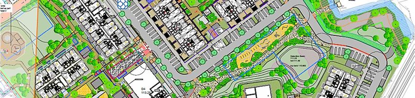
FIGURE 3.17: Proposed Development Site Layout
Vehicle Access
3.6.4 Access to / from the subject site is proposed to be via two locations on Citywest
Avenue. Figure 3.18 below which illustrates the recently constructed Citywest
Avenue signal-controlled junction. The second site access will also be available
in the form of an emerging priority-controlled junction constructed to the west
DBFL Consulting Engineers p190003SHD Development at Cooldown Commons Phase 3 38
Mobility Management Plan
as part of the adjoining Cooldown Commons Phase 2 Development (Pl. Ref.
ABP302398) (This entrance to the site can be accessed along the southern end
of the development). A potential third access that could be used by residents
in the future will be a new priority junction that will be constructed as part of
the permitted development to the northeast of the subject site (Pl. Ref.
16A/0078).
All Modes
Pedestrians / Cyclists
Potential Future – All modes
Maintenance Access
FIGURE 3.18: Site Access Strategy
Pedestrian / Cycle Access
3.6.5 In addition to the aforementioned vehicle access locations which both
pedestrians and cyclists will also avail of with dedicated cycle / pedestrian links,
a dedicated non-vehicular access point is proposed in the south west of the site
providing direct access to Fortunestown Lane and the Fortunestown LUAS
interchange as presented in Figure 3.19 below. An additional non-vehicular
connection is proposed between the subject site and the park to the east via a
proposed new bridge across the existing stream (Figure 3.18 above).
DBFL Consulting Engineers p190003SHD Development at Cooldown Commons Phase 3 39
Mobility Management Plan
Existing non- Proposed non-
vehicular vehicular
connection connection
FIGURE 3.19: LUAS Pedestrian Accessibility
Car Parking Provision
3.6.6 Car parking is proposed to be provided at surface and basement level. The
emerging proposals incorporate a total of 289 no. car parking spaces
comprising 108 no. surface level car parking spaces and 181 no. basement level
car parking spaces. A summary of car parking provision is detailed in Table
3.4 below.
SDCC DHPLG Proposed
Unit Type
Zone 2 Central/Accessible Surface Basement
Apartment 357 38 181
Duplex 41 "...minimised, 591 -
Retail (D3) 11
substantially reduced 5 -
or wholly
Non Residential (E1) 12 eliminated…" 4 -
Luas Set Down - 2 -
Total 421 - 289
1 Inclusive of 1 no. accessible set down space
TABLE 3.4: Proposed Car Parking Provision
3.6.7 The total car parking provision on site has been determined with regard to the
proposed development schedule and the associated SDCC and DHPLG car
parking requirements. The SDCC County Development Plan car parking
standards require a ‘maximum’ provision of 398 no. residential car parking
spaces (excluding 23 no. non-residential car parking spaces) which is higher
than that proposed for the apartment and duplex units (278 proposed).
Nevertheless, the DHPLG states that “ planning authorities must consider a
reduced overall car parking standard and apply an appropriate maximum car
DBFL Consulting Engineers p190003You can also read