Strategic Beach Management Plan: Southeast Atlantic Coast Region - Office of Resilience and Coastal Protection Florida Department of Environmental ...
←
→
Page content transcription
If your browser does not render page correctly, please read the page content below
Strategic Beach Management Plan:
    Southeast Atlantic Coast Region
   Office of Resilience and Coastal Protection
Florida Department of Environmental Protection
                 April 2020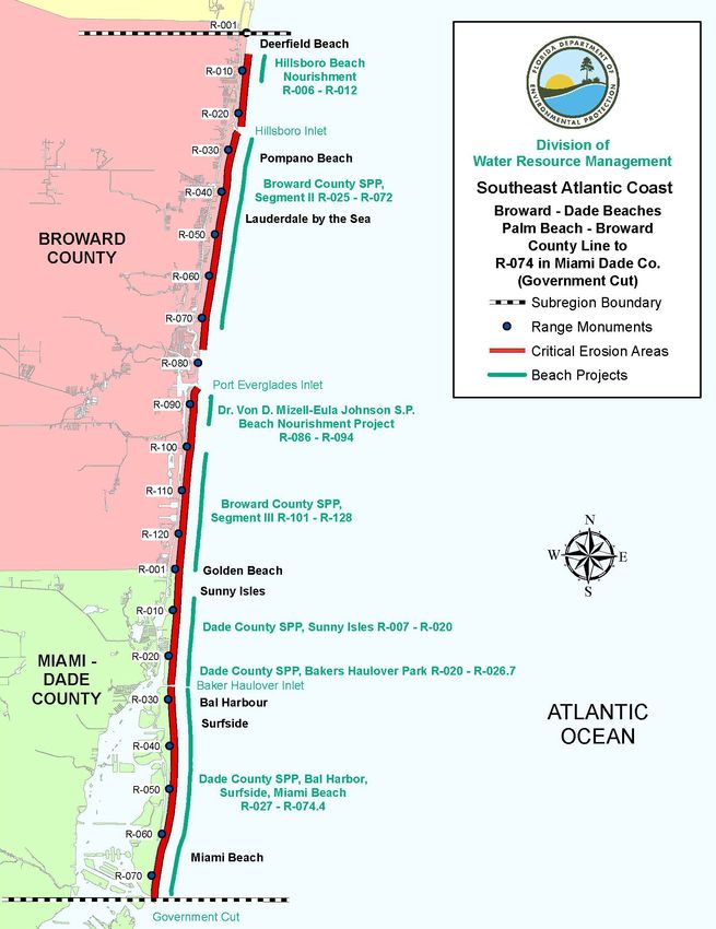
Florida Department of Environmental Protection, Strategic Beach Management Plan – Southeast Atlantic Coast Region

Table of Contents

Introduction - Southeast ........................................................................................................................... 1
Northern Palm Beaches ............................................................................................................................ 2
   Strategies for Inlets and Critically Eroded Beaches .......................................................................... 2
       Blowing Rocks Beach, Martin County, R126-R127.4 ........................................................................ 2
       Coral Cove Park, Tequesta, and Jupiter Inlet Colony, Palm Beach County, R1-R10......................... 3
       Jupiter Inlet, Palm Beach County, R12-R13 ....................................................................................... 3
       Jupiter-Carlin, Palm Beach County, R12-R19 .................................................................................... 4
       Town of Jupiter, Palm Beach County, R19-R26 ................................................................................. 5
       Juno Beach, Palm Beach County, R26-R38 ........................................................................................ 6
       Singer Island, Palm Beach County, R60.5-R69 .................................................................................. 7
   Regional Strategies for Beach and Inlet Management ...................................................................... 8
       Sponsors and Funding ......................................................................................................................... 8
       Project Coordination............................................................................................................................ 9
       Environmental Protection .................................................................................................................... 9
       Sand Sources ..................................................................................................................................... 10
       Additional Information ...................................................................................................................... 10
References ................................................................................................................................................ 12
Palm Beaches ........................................................................................................................................... 14
   Strategies for Inlets and Critically Eroded Beaches ........................................................................ 14
       Lake Worth Inlet, Palm Beach County, R75-R76 ............................................................................. 14
       Town of Palm Beach, Palm Beach County, R76-R134.4.................................................................. 16
       Southern Palm Beach, Lantana and Manalapan, Palm Beach County, R134.1- R145.8 .................. 20
       South Lake Worth Inlet, Palm Beach County, R151-R152............................................................... 21
       Ocean Ridge, Palm Beach County, R152-R168................................................................................ 22
   Regional Strategies for Beach and Inlet Management .................................................................... 23
       Sponsors and Funding ....................................................................................................................... 23
       Project Coordination.......................................................................................................................... 24
       Environmental Protection .................................................................................................................. 24
       Sand Sources ..................................................................................................................................... 25
       Additional Information ...................................................................................................................... 25
References ................................................................................................................................................ 27

April 2020, Page i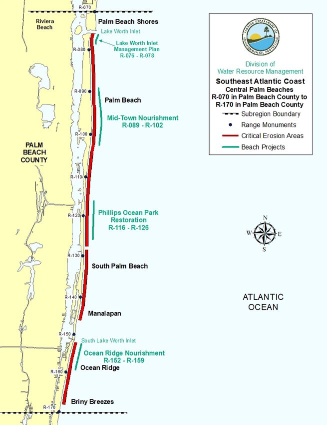
Florida Department of Environmental Protection, Strategic Beach Management Plan – Southeast Atlantic Coast Region

Southern Palm Beaches .......................................................................................................................... 29
   Strategies for Inlets and Critically Eroded Beaches ........................................................................ 29
       Delray Beach, Palm Beach County, R176-R190............................................................................... 29
       Boca Raton, Palm Beach County, R204-R223.................................................................................. 30
       Boca Raton Inlet, Palm Beach County, R222-R223 ......................................................................... 32
       South Boca Raton, Palm Beach County, R223-R227.9 .................................................................... 32
   Regional Strategies for Beach and Inlet Management .................................................................... 33
       Sponsors and Funding ....................................................................................................................... 33
       Project Coordination.......................................................................................................................... 34
       Environmental Protection .................................................................................................................. 34
       Sand Sources ..................................................................................................................................... 35
       Additional Information ...................................................................................................................... 35
References ................................................................................................................................................ 38
Broward – Miami-Dade Beaches ........................................................................................................... 40
   Strategies for Inlets and Critically Eroded Beaches ........................................................................ 40
       Hillsboro Beach, Broward County, R6-R23...................................................................................... 40
       Hillsboro Inlet, Broward County, R24-R25 ...................................................................................... 42
       Pompano Beach to Fort Lauderdale, Broward County, R25-R77 ..................................................... 42
       Port Everglades Inlet, Broward County, R85-R86 ............................................................................ 44
       Dr. Von D. Mizell-Eula Johnson State Park – Dania Beach – Hollywood – Hallandale Beach,
       Broward County, R86-R128 .............................................................................................................. 45
       Golden Beach – Sunny Isles – Haulover Beach Park, Miami-Dade County, R1- R26.7 .................. 48
       Baker’s Haulover Inlet, Miami-Dade County, R26-R27................................................................... 50
       Bal Harbour, Miami-Dade County, R27-R31 ................................................................................... 51
       Surfside, Miami-Dade County, R31-R38 .......................................................................................... 52
       Miami Beach, Miami-Dade County, R38-R74.4............................................................................... 53
       Government Cut, Miami-Dade County, R74 – R75 .......................................................................... 56
   Regional Strategies for Beach and Inlet Management .................................................................... 57
       Sponsors and Funding ....................................................................................................................... 57
       Project Coordination.......................................................................................................................... 58
       Environmental Protection .................................................................................................................. 58
       Sand Sources ..................................................................................................................................... 59
       Additional Information ...................................................................................................................... 59

April 2020, Page ii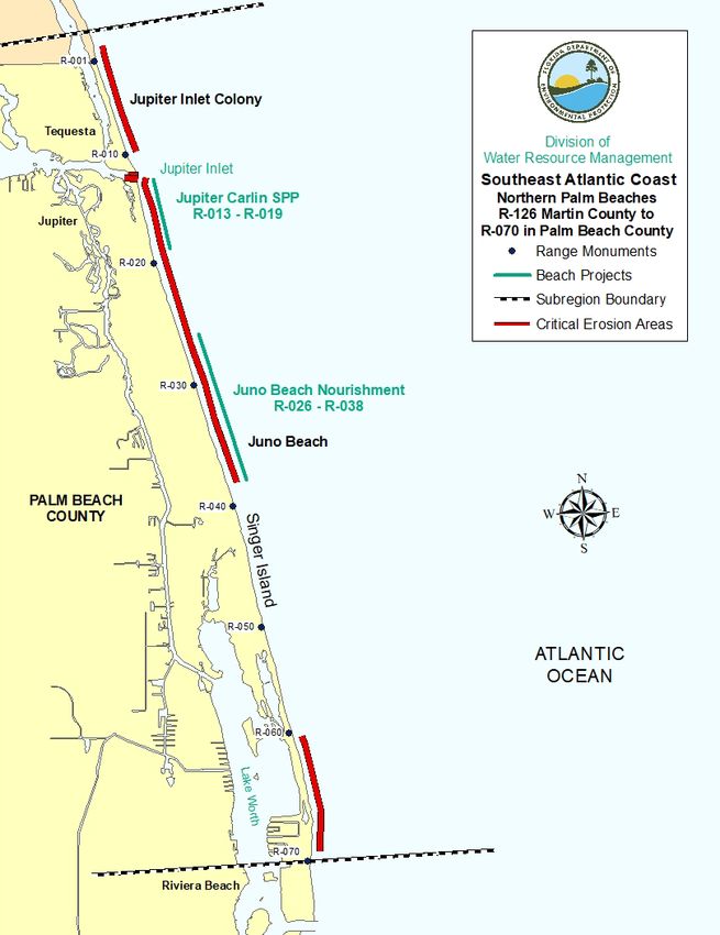
Florida Department of Environmental Protection, Strategic Beach Management Plan – Southeast Atlantic Coast Region
References ................................................................................................................................................ 61
Southern Barriers ................................................................................................................................... 65
Strategies for Inlets and Critically Eroded Beaches ........................................................................ 65
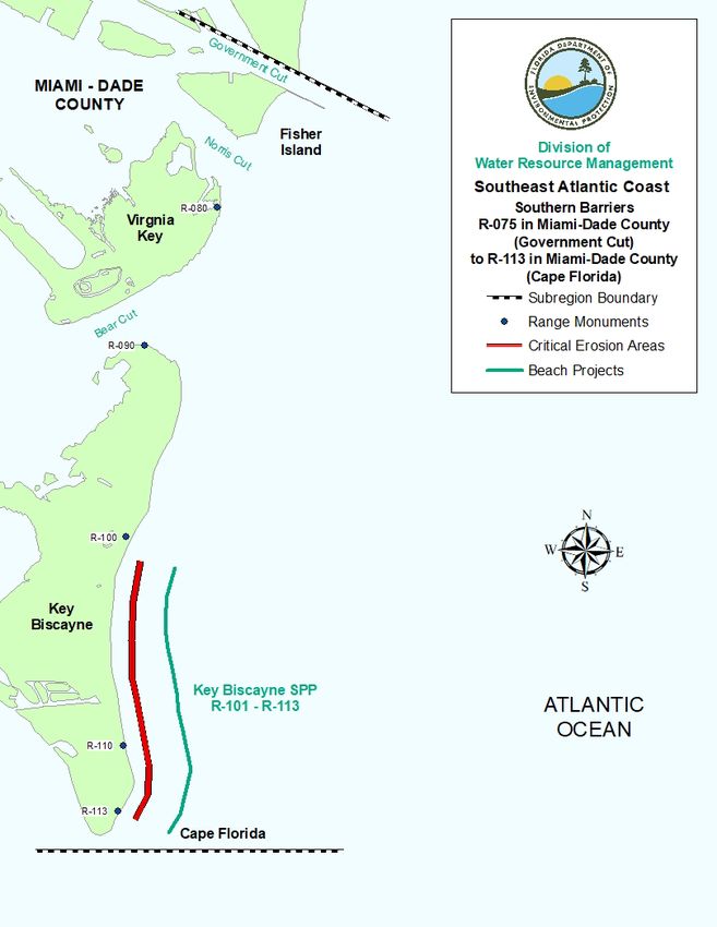
Norris Cut (R78-R79) and Bear Cut (R88-R89), Miami-Dade County ............................................ 65
Key Biscayne, Miami-Dade County, R101-R113 ............................................................................. 66
Regional Strategies for Beach and Inlet Management .................................................................... 67
Sponsors and Funding ....................................................................................................................... 67
Project Coordination.......................................................................................................................... 68
Environmental Protection .................................................................................................................. 68
Sand Sources ..................................................................................................................................... 68
Additional Information ...................................................................................................................... 68
References ................................................................................................................................................ 71
Appendix - Acronyms ................................................................................................................................ i
April 2020, Page iii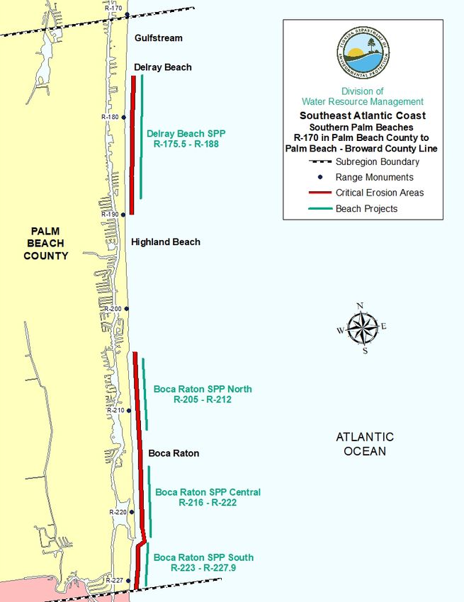
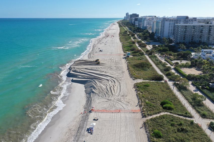
Florida Department of Environmental Protection, Strategic Beach Management Plan – Southeast Atlantic Coast Region

 Miami-Dade County Shore Protection Project (USACE) - Surfside Segment. Photo courtesy of Continental Heavy Civil Corp (CHC) and
 taken on January 15th, 2020.

April 2020, Page iv
Florida Department of Environmental Protection, Strategic Beach Management Plan – Southeast Atlantic Coast Region

 Introduction - Southeast

 The Southeast Atlantic Coast Region has a total of 91.1 miles of beaches of which, 72.1 miles are
 critically eroded, and 48.1 miles are actively managed. There are also ten inlets within the Southeast
 Atlantic Region and seven of those inlets have an inlet management plan. For additional beach
 management or project information, see the current Critically Eroded Beaches Report, the joint coastal
 permits by County or the local government funding requests by County. Each subregion listed below
 will have the introductory paragraph listing miles of coastline and erosional events/storms that have
 affected the subregion.

 Each title within the subregion will list the coastal location, the County and the Department of
 Environmental Protection (Department or DEP) reference or range (R) monuments for the critical
 erosion area. For inlets, river entrances or passes, the title, the County and the adjacent range survey
 markers will be stated. In addition, there will be a subregion map highlighting the critical erosion
 areas and the managed project areas. Finally, references to coastal reports will also be listed at the end
 of each subregion.

 For more specific information concerning projects or strategies along Florida’s coastline, see the
 following links for the other six coastal regions of Florida and for background information, see
 the Strategic Beach Management Plan’s Introduction.

         Strategic Beach Management Plan Introduction
         Northeast Atlantic Coast Region
         Central Atlantic Coast Region
         Florida Keys Region
         Southwest Gulf Coast Region
         Big Bend Gulf Coast Region
         Panhandle Gulf Coast Region
 For additional information pertaining to beach and ocean conditions, coastal associations,
 educational institutions or government agencies, see the following related coastal sites.

 The state of Florida was significantly impacted by three hurricanes, Hermine, Matthew and Irma
 during the 2016 and 2017 hurricane seasons. To see additional information for strategies and funding
 to address recovery for the beaches and dunes, see the “Hurricane Damage Assessment Report for
 2016: Florida's Beaches and Dunes.” For the 2017 hurricane season, see the “Hurricane Irma Post-

April 2020, Page 1 of 72
Florida Department of Environmental Protection, Strategic Beach Management Plan – Southeast Atlantic Coast Region

 Storm Beach Conditions and Coastal Impact in Florida” report. The post-storm survey data has been
 fully analyzed and an updated list of critically eroded beaches is in the Critically Eroded Beaches
 Report.

 Northern Palm Beaches

 There are 13.3 miles of beaches in the Northern Palm Beaches subregion, which extends from
 just north of the Martin-Palm Beach county line to Riviera Beach (R70) on Singer Island in Palm
 Beach County, as shown on Figure 1. There are 8.4 miles of critically eroded beaches in this
 subregion, of which 3.5 miles have been restored and maintained.

 Erosion is attributed to frequent northeasters, occasional tropical storms and hurricanes, and the
 effects of Jupiter Inlet. The most erosive storms occurring in past years were Hurricane David
 (1979), the Thanksgiving Day Northeaster (1984), Hurricane Irene (1999), Hurricane Frances and
 Jeanne (2004), Hurricane Wilma (2005), Subtropical Storm Andrea (2007), October northeasters
 (2007), Hurricane Noel (2007), Tropical Storm Fay (2008), Hurricane Sandy (2012), Hurricane
 Matthew (2016) and Hurricane Irma (2017).

 Strategies for Inlets and Critically Eroded Beaches

 Blowing Rocks Beach, Martin County, R126-R127.4

 This is a 0.2-mile segment of critically eroded beach on southern Jupiter Island, south of the Blowing
 Rocks Preserve public access in Martin County, where private development is threatened. Anastasia
 formation creates an exposed rock headland within the Preserve. The area south of the Preserve is
 subject to dynamic erosion and accretion cycles on the downdrift side of the rock headland. In
 response to the 2004 hurricanes, a dune restoration project was constructed in 2008. Hurricane Sandy
 in 2012 caused erosion to the dunes and repairs to the dune were necessary. The dune repair was
 completed in November of 2012 with the placement of approximately 8,600 cubic yards (cy) that
 restored 1,100 ft of dune between R126-R127. In addition, roughly 200 cy of sand was placed within
 the seaward edge of the dune along each of the nine properties in that area. Due to impacts from
 Hurricanes Matthew (2016) and Irma (2017), a dune restoration project was complete in December
 2017, placing roughly 4,800 cubic yards of sand as a truck haul project, repairing losses to the
 dune. The upper limits of the dune for both the 2012 and 2017 projects were re-vegetated with sea
 oats. To address losses sustained in Hurricane Dorian (2019), the Town is planning to re-construct the
 dune at Blowing Rocks beach between R126 and R127.4 in 2020.

April 2020, Page 2 of 72
Florida Department of Environmental Protection, Strategic Beach Management Plan – Southeast Atlantic Coast Region

 Strategy: Maintain dune project and monitor.

 Coral Cove Park, Tequesta, and Jupiter Inlet Colony, Palm Beach County, R1-R10

 This is a 1.5-mile segment of critically eroded beach on southern Jupiter Island in Palm Beach
 County. It includes the communities of Tequesta and Jupiter Inlet Colony. A dune restoration project
 was completed within the boundaries of Coral Cove Park in 1989. Another dune restoration project
 was completed in Coral Cove Park (R5-R7.6) in 1993, using sand trucked to the site from an upland
 source. Discrete segments of armoring has been constructed along private development in Tequesta.
 This area was severely impacted by Hurricanes Frances and Jeanne in 2004. Following the 2004
 hurricane season, emergency protective berms were constructed in 2005 using funds from FEMA and
 again in 2012 using state and local funds after the passage of Hurricane Sandy. A dune restoration
 project was completed in 2014 placing approximately 25,926 cy of material on the dune. The next
 dune project is scheduled for 2019/2020.

 Strategy: Maintain dune project and monitor.

 Jupiter Inlet, Palm Beach County, R12-R13

 Jupiter Inlet is maintained by the Jupiter Inlet District. The 0.8 miles of inlet shoreline to the north and
 south of Jupiter Inlet have been designated as critically eroded inlet shoreline. The sediment
 impoundment basin located within the navigation channel is routinely dredged to a depth of -20 ft
 NGVD with the sand placed on the downdrift beach south of the inlet. The placement area (R12 –
 R19) is within the same template as the Jupiter-Carlin project limits. The Department adopted the
 Jupiter Inlet Management Study Implementation Plan in October 1997 that established an annualized
 bypassing objective of 75,000 cy. In 1999, the crests of both north and south jetties were raised, the
 south jetty was extended seaward, and the sediment impoundment basin was expanded as
 recommended in the adopted plan. Approximately 50,000 cy of sand was dredged from the inlet
 sediment impoundment basin in 2019 and placed between R13 to R19. Learn more about Jupiter Inlet
 District projects and history.

 Strategy: Bypass sediment to downdrift beaches to meet an annualized bypassing objective of
 75,000 cy; continue a physical monitoring program and, based on the results, update the sediment
 budget and then update the inlet management plan.

April 2020, Page 3 of 72
Florida Department of Environmental Protection, Strategic Beach Management Plan – Southeast Atlantic Coast Region

 Jupiter-Carlin, Palm Beach County, R12-R19

 This is a 1.1-mile segment of critically eroded beach between Jupiter Beach Park and Carlin Park that
 is partially in the area of influence of Jupiter Inlet. The federal General Design Memorandum was
 approved in 1994, and the project history for this segment of shoreline is described in Table 1.
 Construction of the federally authorized Jupiter-Carlin Shore Protection Project (R13-R19), also
 known as Segment I, was completed using sand from the ebb tidal shoal of Jupiter Inlet in April
 1995. The project is authorized until 2039. The local sponsor is Palm Beach County. The project
 design consists of a beach berm at elevation +7.5 ft NAVD that constitutes seven years of advance
 nourishment to protect the existing dune and upland development. The project included construction
 of 3.5 acres of artificial reef to mitigate for adverse impacts to ephemerally exposed nearshore
 hardbottom. The project generally met its performance goal of protecting the dune and upland
 property, except in the Jupiter Beach Park, which experienced severe erosion.

 After the 1995 restoration project, periodic placement of sand in the area coincided with maintenance
 dredging of Jupiter Inlet and the Intracoastal Waterway. Jupiter Inlet District completed a 175-ft
 extension to the south jetty in 1998, possibly contributing to the migration of the erosion hotspot from
 Jupiter Beach Park south to Ocean Trail Condominium. The north jetty height and width were also
 increased. Beach nourishment was completed in March 2002, using sand from an offshore borrow
 site. A study to evaluate alternatives to address the erosional hotspot at Jupiter Beach Park was
 finalized in 2007. Dune restoration was completed in December of 2007 between R13-R17 to address
 damage from Subtropical Storm Andrea. The County completed a large-scale, non-federal dune
 maintenance project in January 2012, using 41,145 cy from an upland sand source. A dune
 maintenance project was completed in January 2013 to replace approximately 6,100 cy lost during
 Hurricane Sandy. Prior to the next federal nourishment, a federal Section 934 report was required to
 evaluate economic feasibility of the project and was fully approved in 2019.

 The project received Flood Control and Coastal Emergencies (FCCE) funding to repair damages
 sustained during Hurricane Sandy. In conjunction with the federal repair project that placed 132,638
 cy of sand, the local sponsor conducted a supplemental local project that placed 282,084 cy from an
 upland sand source. Construction of the federal project began in February 2014 but was delayed until
 winter. The federal project was completed in January 2015 and the local project was completed in
 March 2015. Together, the two projects placed a total volume of 423,084 cy on the beach. Additional
 dredged material from the inlet sand trap was placed on the beach totaling 45,300 cy. The Intracoastal

April 2020, Page 4 of 72
Florida Department of Environmental Protection, Strategic Beach Management Plan – Southeast Atlantic Coast Region

 Waterway and inlet sand trap were dredged again in 2017, placing a total of 164,931 cy on the beach.
 The Department issued a major permit modification in 2018 to incorporate dune restoration between
 R19 and R26, and to include the Juno Beach Nourishment Project under a single authorization. The
 project will be referred to as the North Palm Beach County Comprehensive Shore Protection Project
 (Segments I thru III). The next beach nourishment project at the Jupiter-Carlin segment is expected to
 be completed in January 2020.

Table 1. Jupiter-Carlin Shore Protection Project history.

                                                                         Project Location
 Date Completed            Volume (cy)               Source                                        Length (mi)
                                                                        (by R monument)

     April 1995              604,000             Ebb Tidal Shoal           R13-R19                       1.1
                                                Sand Transfer –          R13-R13.5 and
         1995                  2,000           trucked from R75           R18-R18.5                      0.3

    March 2002               625,000                 Offshore                R13-R19                     1.1

    January 2012              41,145                 Upland                  R13-R19                     1.1

    January 2013               6,100                 Upland             Between R13-R19                  0.4

    January 2014               4,000                 Offshore           Between R13-R19                  0.4

    January 2015             141,000                 Offshore               R13-R15.5                    0.4

    March 2015               282,084                 Upland                 R15.5-R19                    0.7

     April 2015               45,300             Inlet Sand Trap            R13-R15.5                    0.4

    March 2017               102,068                 AIWW                   R14-R16.5                    0.4

    March 2017                62,863             Inlet Sand Trap            R14-R16.5                    0.4

    January 2020             590,571                 Offshore               R13.5-R19                    1.0

 Strategy: Maintain the project through monitoring and nourishment.

 Town of Jupiter, Palm Beach County, R19-R26

 This is a 1.5-mile segment of critically eroded beach that is partially within the area of influence of
 Jupiter Inlet. No projects have been conducted in this segment of critically eroded beach.
 Nourishment projects at Jupiter/Carlin have provided a degree of stability to the shoreline in this
 segment through longshore transport of fill. Despite this updrift littoral supply, the shoreline in this

April 2020, Page 5 of 72
Florida Department of Environmental Protection, Strategic Beach Management Plan – Southeast Atlantic Coast Region segment has continued to retreat. During a period of high seas in 2015, multiple dune cross-overs were damaged or destroyed and the dunes were severely impacted, increasing the vulnerability of the hurricane evacuation route State Road A1A. The County placed approximately 3,530 cy of sand from an upland sand source in February 2016 to restore the dune from 230 ft north of R20 to 300 ft north of R21 to increase storm protection to upland infrastructure. The Department recently issued a major permit modification in 2018 to the Jupiter Carlin Beach Nourishment Project to incorporate dune restoration between R19 and R26 (Segment II) and to include the Juno Beach Nourishment Project under a single authorization. The project will be referred to as the North Palm Beach County Comprehensive Shore Protection Project. The County is currently conducting a feasibility study to evaluate various shoreline protection alternatives. Strategy: Monitor; conduct dune restoration; conduct a feasibility study. Juno Beach, Palm Beach County, R26-R38 This is a 2.4-mile segment of critically eroded beach. The project history for this segment of shoreline is described in Table 2 and the local sponsor is Palm Beach County. Initial construction of the Juno Beach Nourishment Project (R26-R38) was completed in 2001 using 1,500,000 cy of sand obtained from an offshore borrow area. The project restored the beach berm at +9 ft NGVD and provided additional fill material equivalent to six years’ advance nourishment. A physical and environmental monitoring program was also required. The first nourishment for this segment was completed in April of 2010 with 916,192 cy of sand from an offshore borrow area. The project initially required construction of 4.47 acres of artificial reef to mitigate for adverse impacts to 3.77 acres of nearshore hardbottom. Construction of the mitigation was completed in 2002. Post-construction aerial photography showed unanticipated coverage of hardbottom. The county proposed to construct an additional 0.75 acre within a permitted nearshore placement area near Singer Island to mitigate for the unintended impacts. Limestone rock boulders and experimental pre- fabricated reef modules were used in the reef design. The secondary impact mitigation was completed in 2011. The current permitted beach berm elevation is +7.5 feet NAVD, with an average berm width of 200 feet. The next nourishment is scheduled for 2019/2020. The Department recently issued a major permit modification in 2018 to the Jupiter Carlin Beach Nourishment Project to incorporate dune restoration between R19 and R26, and to include the Juno Beach Nourishment Project (Segment III) under a single authorization. The project will be referred to as the North Palm Beach County Comprehensive Shore Protection Project. April 2020, Page 6 of 72
Florida Department of Environmental Protection, Strategic Beach Management Plan – Southeast Atlantic Coast Region

Table 2. Juno Beach Nourishment Project history.

          Date                                                      Project Location         Length
                             Volume (cy)            Source
        Completed                                                  (by R monument)            (mi)
                                                  Offshore
        March 2001            1,500,000                                 R26-R38                 2.4
                                                 Borrow Site
                                                  Offshore
        April 2010             916,192                                  R26-R38                 2.4
                                                 Borrow Site

 Strategy: Maintain the project through monitoring and nourishment.

 Singer Island, Palm Beach County, R60.5-R69

 This is a 1.7-mile segment of critically eroded beach on Singer Island, and the project history for
 this segment of shoreline is described in Table 3. The local sponsor is Palm Beach County. A large
 rock outcrop (R67) influences littoral sand transport and the width of the beach at Ocean Reef Park
 (R67-R68). North of the rock outcrop, erosion of the dune bluff threatens upland structures.
 Beginning in 2000, the county placed sand along the eroded dune bluff to protect upland structures.
 The Department and the county initiated the first phase of a feasibility study of coastal erosion
 control structures in March 2001. Preliminary findings were inconclusive. An additional feasibility
 study was concluded in 2005, recommending the placement of beach erosion control structures.
 The county began permitting activities to construct 14 offshore breakwaters between R61-R68 in
 2006. The project was modified to 11 breakwaters due to concerns of downdrift impacts. The
 breakwater design did not receive favorable approval by regulatory agencies. An alternatives
 analysis was completed in July 2010 and a submerged breakwater design was proposed. The
 project was permitted by the Department, but it was not pursued by the county. Since 2013, seven
 upland properties have constructed seawalls to armor approximately 2,300 linear feet. A dune
 restoration project for a new segment was authorized under a CCCL permit in 2015. The truck haul
 project was completed in April 2016 placing approximately 11,822 cy of sand. The Singer Island
 dune project was completed again in February 2017, with placement of 54,829 cy of sand between
 R60.7 and R66.9. A FEMA storm recovery dune project is scheduled for 2019/2020.

April 2020, Page 7 of 72
Florida Department of Environmental Protection, Strategic Beach Management Plan – Southeast Atlantic Coast Region
Table 3. Dune maintenance events in Singer Island.
Date Project Location Length
Volume Source
Completed (by R monument) (mi)
(cy)
2000-2001 10,000 Upland R60.5 to R69 1.7
2003-2004 13,000 Upland R60.5 to R69 1.7
2004-2005 56,000 Upland R60.5 to R69 1.7
2005-2006 30,000 Upland R60.6 to R63.5 0.5
2006-2007 49,338 Upland R60.5 to R69 1.7
2007 Emergency
49,955 Upland R60.5 to R65.5 1.0
Placement
2007-2008 50,697 Upland R60.5 to R65.5 1.0
2010-2011 30,313 Upland R60.5 to R65.5 1.0
2012-2013 55,581 Upland R60.5 to R65.5 1.0
2014-2015 46,803 Upland R60.5 to R65.5 1.0
2015-2016 11,822 Upland R65.5 to R66.8 0.3
February 2017 54,829 Upland R60.7 to R66.9 1.2
Strategy: Maintain the dune project and monitor; reevaluate beach erosion control alternatives.
Regional Strategies for Beach and Inlet Management
Sponsors and Funding
Palm Beach County, the local sponsor of both the Jupiter-Carlin Park and Juno Beach projects,
constructed the Jupiter-Carlin Park project with reimbursement funding provided by the Department.
Palm Beach County decided not to seek federal participation in the Juno Beach project in order to
shorten the time between the planning phase and project construction. Palm Beach County’s Shoreline,
dated 2014, highlights the Counties initiatives to preserve and manage their coastline. The Department
also participates with Jupiter Inlet District on inlet management activities at Jupiter Inlet and with Palm
Beach County on dune construction projects. Project cost estimates and schedules may be found in the
Beach Management Funding Assistance Program – Long Range Budget Plan.
April 2020, Page 8 of 72Florida Department of Environmental Protection, Strategic Beach Management Plan – Southeast Atlantic Coast Region
Project Coordination
Regionalization is the funding and coordination of multiple beach nourishment and inlet management
activities to take advantage of identifiable cost savings through economies of scale, reduced
equipment mobilization and demobilization costs, and elimination of duplicative administrative tasks.
Opportunities in this subregion include:
1. Coordination of maintenance dredging of Jupiter Inlet and the adjacent Atlantic
Intracoastal Waterway with maintenance of the Jupiter-Carlin project.
2. Jointly soliciting bids for the nourishment of the Jupiter-Carlin Park and Juno Beach
projects with other projects in the region.
3. A regional beach, inlet and offshore data collection and processing program to be used by
the local sponsor for project monitoring is recommended.
Environmental Protection
The protection of marine turtles and hardbottom/reef habitat are the primary environmental concerns
within this subregion. Sensitive areas for shorebirds include Blowing Rocks Preserve and John D.
MacArthur State Park. Sensitive areas for beach mice include Coral Cove Park, Jupiter Beach Park,
Carlin Park, Juno Dunes Natural Area, and John D. MacArthur Beach State Park. Within those
sensitive areas, natural communities identified as primary and secondary dunes as well as scrub
dunes, back dunes, coastal scrub and or coastal strand all provide essential habitat for beach mouse
populations. Additionally, primary dunes and secondary dunes that occur on private lands are
important for resilience of those developed lands and sustaining wildlife populations and should be
maintained or restored. These areas can be subject to change as conditions change, and coordination
with FWC shorebird staff and the FWC Regional Species Conversation Biologist for the FWC region
where the project is occurring is encouraged during project development. The projects have been
designed and implemented to avoid or minimize adverse impacts to marine turtles and hardbottom
and reef habitat. The timing of construction activities has been restricted during the sea turtle nesting
season of March 1 through October 31. Some parts of Palm Beach County have been reporting record
nesting events through 2015. Artificial reefs have been constructed as mitigation to offset adverse
impacts to nearshore hardbottom caused by the Jupiter-Carlin and Juno Beach projects and are being
monitored.
April 2020, Page 9 of 72Florida Department of Environmental Protection, Strategic Beach Management Plan – Southeast Atlantic Coast Region
Sand Sources
Due to the fact that there are limited sand resources existing in state waters in Southeast Florida, the
Department and the United States Army Corps of Engineers (USACE) completed the Sediment
Assessment and Needs Determination (SAND) study. This study was conducted in a collaborative
manner and it was reviewed by and vetted through all the participating stakeholders. The SAND
study indicates that the regional offshore supply of sand in state and federal waters is more than
adequate to meet the volumetric needs of all the beach nourishment projects in the five southeastern
coastal counties, St. Lucie, Martin, Palm Beach, Broward, and Miami-Dade, for the next 50 years
(year 2062), according to Ousley et al. (2014). Subsequently, the Department analyzed the need for
sand over the next 10 to 20 years for the five southeastern counties and determined that
approximately 20 to 30 million cy will be needed for beach nourishment projects. Due to the narrow
continental shelf adjacent to Florida’s southeastern shoreline, it is expected that some counties may
need to look for sand resources in upland sand mines and/or offshore borrow sites in neighboring
counties. Miami-Dade County has already initiated this process.
Coordination is recommended between the Department, the USACE, BOEM and Local Governments
to use best management practices with these offshore resources. For additional information on sand
sources, the Department manages a database named the Regional Offshore Sand Source Inventory
(ROSSI).
Additional Information
The introduction of the state’s Strategic Beach Management Plan provides additional background
information on the Department’s Beach Management Programs and includes overviews of:
• The principles and statutes followed to help guide the state’s management strategies
• Comprehensive list of Florida’s inlets
• The miles of critically eroded beaches under active management
• Statewide sand source studies
• Statewide monitoring programs
• Innovative technologies examined
• Basic suggestions for emergency response plans
April 2020, Page 10 of 72Florida Department of Environmental Protection, Strategic Beach Management Plan – Southeast Atlantic Coast Region Figure 1. Map of Northern Palm Beaches subregion of the Southeast region of Florida. View an interactive map or COASTS imagery. April 2020, Page 11 of 72
Florida Department of Environmental Protection, Strategic Beach Management Plan – Southeast Atlantic Coast Region

 References

 Albada, E., and Craig, K., 2006. Jupiter/Carlin Shore Protection Project, Palm Beach County, Florida:
         24 Month Monitoring Report, Taylor Engineering, Inc., Report No. C2005-050, 52 p.

 Applied Technology & Management, Inc., 2005. Juno Beach Shore Protection Project Post-
         Construction Monitoring Report Years 1, 2 and 3, 42 p.

 Balsillie, J. H., 1985. Post-Storm Report: the Florida East Coast Thanksgiving Holiday Storm of 21-
         24 November 1984, Florida Department of Natural Resources, Division of Beaches and
         Shores, Post-Storm Report No. 85-1, 74 p.

 Clark, R.R., LaGrone, J.W., and Koch, J.L, 2006. Hurricane Wilma: Post-Storm Beach Conditions
         and Coastal Impact Report, Florida Department of Environmental Protection, Bureau of
         Beaches and Coastal Systems, 98 p.

 Clark, R.R., LaGrone, J.W., Brantly, R.., 2004. Hurricane Frances & Hurricane Jeanne: Post-Storm
         Beach Conditions and Coastal Impact Report with Recommendations for Recovery and
         Modifications of Beach Management Strategies, Florida Department of Environmental
         Protection, Bureau of Beaches and Coastal Systems, 93 p.

 Clark, R.R., 2000. The Impact of Hurricanes Floyd and Irene on the Florida East Coast, Florida
         Department of Environmental Protection, Bureau of Beaches and Coastal Systems, Report
         No. 00-01, 55 p.

 Coastal Planning and Engineering, Inc., 1998. Juno Beach Shore Protection Project Feasibility Study.

 Coastal Planning and Engineering, Inc., 1993. General Design Memorandum Addendum for
         Jupiter/Carlin Segment with Supplement to the Environmental Impact Statement - Palm Beach
         County, Florida, from Martin County Line to Lake Worth Inlet and from South Lake Worth
         Inlet to Broward County Line, June 1991 (revised May 1993).

 Florida Department of Environmental Protection. 2004 Hurricane Recovery Plan for Florida’s Beach
         and Dune System, 65 p.

 Florida Department of Environmental Protection, 2019. Critically Eroded Beaches in Florida,
          Division of Water Resource Management, 89 p.

April 2020, Page 12 of 72
Florida Department of Environmental Protection, Strategic Beach Management Plan – Southeast Atlantic Coast Region
Florida Department of Environmental Protection, 1997. Jupiter Inlet Management Study
Implementation Plan, 8 p.
Humiston and Moore Engineers. Singer Island Erosion Control Project, Evaluation of Low Profile
Groins and T-Groins Alternatives, Technical Report. Humiston and Moore, 2012.
Mehta, A. J., Montegue, C. L., and Theike, R. J., 1992. Erosion, Navigation and Sedimentation
Imperatives at Jupiter Inlet, Florida: Recommendations for Coastal Engineering
Management, Coastal and Oceanographic Engineering Department, University of Florida,
COEL-92/002, 213 p.
Ousley, J.D., Kromhout, E., Schrader, M.H., Lillycrop, L., 2014. Southeast Florida sediment
assessment and needs determination (SAND) study, Final Report, ERDC/CHL TR-14-10, U.S.
Army Corps of Engineers, 321 p.
Palm Beach County Department of Environmental Resources Management, 1999. Palm Beach
County Shore Protection Plan, Florida.
Palm Beach County Department of Environmental Resources Management. Singer Island
Erosion Control Reef System, Alternatives Analysis. Palm Beach County, 2010.
U. S. Army Corps of Engineers, 1998. Water Resources Development in Florida.
U. S. Army Corps of Engineers and Florida Department of Environmental Protection, 1997. Coast
of Florida Erosion and Storm Effects Study, Region III.
U.S. Army Corps of Engineers, 1987. Beach Erosion Control Projects for Palm Beach County,
Florida - General Design Memorandum with Environmental Impact Statement.
April 2020, Page 13 of 72Florida Department of Environmental Protection, Strategic Beach Management Plan – Southeast Atlantic Coast Region Palm Beaches There are 20.7 miles of beach in the Palm Beaches subregion, which extends from Palm Beach Shores (R70) on Singer Island to Gulfstream (R170) in Palm Beach County, as shown on Figure 2. There are 17.5 miles of critically eroded beaches in this subregion, 8.2 miles of which have been restored or maintained. Erosion is attributed to frequent northeasters, occasional tropical storms and hurricanes, and the effects of Lake Worth Inlet and South Lake Worth Inlet. The most erosive storms occurring in past years were Hurricane David (1979), the Thanksgiving Day Northeaster of 1984, Hurricane Irene (1999), Hurricanes Frances and Jeanne (2004), Hurricane Wilma (2005), Subtropical Storm Andrea (2007), October northeasters (2007), Hurricane Noel (2007), Tropical Storm Fay (2008), Hurricane Sandy (2012), Hurricane Matthew (2016) and Hurricane Irma (2017). Strategies for Inlets and Critically Eroded Beaches Lake Worth Inlet, Palm Beach County, R75-R76 Lake Worth Inlet, part of the federal Palm Beach Harbor Navigation Project, is periodically dredged to maintain a navigation channel depth of -35 ft MLLW. The channel is dredged typically every one or two years, and the sand is placed either on the downdrift beach within 3,000 ft of the south jetty or in a permitted nearshore location. A sand transfer plant, maintained by the Town of Palm Beach and operated by Palm Beach County, was constructed on the north jetty in 1958 by the USACE. A settling basin north of the north jetty was built by the USACE between 1958 and 1968. The south jetty received repairs along with sand tightening in 1986. The sand transfer plant bypasses sand to the downdrift beach immediately south of the south jetty. The sand transfer plant continued to function until 1990 until it became inactive for six years due to a rusted transfer pipe. The sand transfer plant was upgraded in 1995 with a more powerful engine and pump, and in May 1996 began to function again. The Department adopted the Lake Worth Inlet Management Study Implementation Plan in 1996, but a bypassing objective was not established at that time. A sediment budget study completed in 2000 recommended bypassing an average annual volume of 202,000 cy to the downdrift beaches. This volume has been bypassed through the downdrift placement of material dredged from the navigation channel and operation of the sand transfer plant. April 2020, Page 14 of 72
Florida Department of Environmental Protection, Strategic Beach Management Plan – Southeast Atlantic Coast Region

 The USACE completed a navigation study in May 2001 that recommended sand tightening the north
 and south jetties, construction of a larger sediment impoundment basin, and renovation of the existing
 sand transfer plant to include a new motor, flood-proofing, and a southerly extension of the discharge
 pipeline. The study recommended that Palm Beach County design and construct the sand transfer
 plant with reimbursement funding from the federal government. In February 2003, design and
 permitting for sand tightening of the jetties was completed and the construction was completed later in
 2003. The Department issued a joint coastal permit authorizing expansion of the settling basin on the
 north side of Lake Worth Inlet in 2006. USACE expanded the sediment impoundment basin on the
 northern side of the channel seaward of the north jetty in 2007. Lake Worth Inlet project activities
 receives regional sediment management (RSM) support by the USACE to manage the sediments in a
 manner that maximizes natural and economic opportunities for the coastal system. The Town of Palm
 Beach constructed a 3.1-acre artificial reef in 2004 to address anticipated impacts from the settling
 basin expansion. During the 2004 hurricane season, the sand transfer plant was damaged and became
 inoperable. To reestablish sediment bypassing, repair of the facility was completed in March 2005
 using FEMA emergency funds. Sand bypassing was suspended between August and December of
 2009 to begin a full rehabilitation of the sand transfer plant. The rehabilitation was completed in April
 2010. In October 2012, the sand transfer plant was damaged again by Hurricane Sandy and was
 rendered inoperable until September 2013. For 20 years or since 1996, the sand transfer plant has
 bypassed approximately 2.6 million cy of sand to the downdrift beaches. Palm Beach Harbor/ Lake
 Worth Inlet was dredged in 2016 with placement of 164,816 cy of beach quality sand between R76
 and R78, and again the Palm Beach Harbor was dredged in February 2018 with placement of 237,923
 cy of beach quality sand between R76 and R79.5.

 Strategy: Bypass an average annual volume of 202,000 cy of sand to the downdrift beaches through a
 combination of the operation of the sand transfer plant and beach placement of maintenance dredge
 material from the federally authorized navigation channel; place all beach compatible material dredged
 during channel maintenance on downdrift beaches in Reach 1, in an extended beach placement in
 Reach 2, and when feasible, at the Mid-Town and Phipps Ocean Park projects; dredging placement
 should be limited to dry beach; extension of the discharge pipeline to discharge points located at the
 south jetty, and approximately 3,600 ft south of the south jetty; comply with the Palm Beach Island
 Beach Management Agreement (BMA), 2013; monitor; update the sediment budget and the inlet
 management plan.

April 2020, Page 15 of 72
Florida Department of Environmental Protection, Strategic Beach Management Plan – Southeast Atlantic Coast Region

 Town of Palm Beach, Palm Beach County, R76-R134.4

 This is a 12.2-mile segment of critically eroded beach where erosion is attributed to the effects of Lake
 Worth Inlet as far south as R121, approximately 50,000 ft. Most of this shoreline is armored with
 seawalls, bulkheads, and revetments. There are also numerous relic and functional groins. The Town of
 Palm Beach is the local sponsor for projects in this area. The area has been divided into eight reaches
 (Reaches 1 through 8). In 2001, the Palm Beach Island Feasibility Study was initiated for three areas
 including Reach 2, Reach 5, and Reach 8, to identify beach nourishment alternatives. Efforts underway
 in Reaches 2, 3, 4, 5, 7, and 8 are discussed below.

 On September 26, 2013, a pilot Beach Management Agreement (BMA) was signed to promote
 regionalization and incorporate cell wide management of Palm Beach Island. The cell on Palm Beach
 Island is 15.7 miles of beach and is between Lake Worth Inlet at R76 and South Lake Worth Inlet at
 R151. The BMA includes the Lake Worth Inlet maintenance dredging placement, the Mid-Town
 project, Phipps Project, groin maintenance and rehabilitation, and dune work throughout the island.
 The BMA incorporates net ecosystem benefits such as annual hardbottom, turtle and physical
 monitoring throughout the cell, retrofitting and minimizing outfalls that release waters onto the coastal
 system, and improved inlet management practices. The BMA is a perpetual and adaptively managed
 agreement that is reviewed annually, with a more detailed review completed every five years. The
 Mid-Town beach nourishment project, as well as interim sand placement in Reach 7 and dune
 restoration in Reach 8, were constructed in 2015. The Phipps Ocean Park Beach Nourishment project,
 including dune restoration in Reaches 3 and 8, was constructed in 2016. See a BMA introductory
 presentation or to see a map and description of the different Reaches (1 through 11), see pages 6 and 7
 of the BMA (agreement). For additional information on the development of the BMA, see the BMA
 document library.

 Reach 1 (R76-R78.5) is a 0.5-mile segment of critically eroded shoreline. This area is directly south
 of Lake Worth Inlet in the Town of Palm Beach. This project area is maintained by inlet sand
 bypassing. Sandy material is bypassed to this project area on an annual basis. Recent bypass
 activities have indicated a deficit of sandy material reaching the settling basin on the north side of
 Lake Worth Inlet.

 The Town of Palm Beach has indicated it will investigate why this sand deficit is occurring at the
 settling basin with goals of improving the annual bypassing objectives. Palm Beach Harbor/ Lake
 Worth Inlet was dredged in 2016 with placement of 164,816 cy of beach quality sand between R76

April 2020, Page 16 of 72
Florida Department of Environmental Protection, Strategic Beach Management Plan – Southeast Atlantic Coast Region

 and R78. Palm Beach Harbor was dredged in February 2018 with placement of 237,923 cy of beach
 quality sand between R76 and R79.5. Again, the Palm Beach Harbor was dredged in December
 2019 with placement of approximately 50,000 cy of beach quality sand between R76 and R78.

 Reach 2 (R78.5-R90.4) is a 2.5-mile segment of critically eroded shoreline. This area includes the
 beach between Onondaga Avenue and El Mirasol in the Town of Palm Beach. The Mid-Town beach
 restoration project was recommended based upon studies conducted in association with the Lake
 Worth Inlet Management Plan to reestablish littoral transport and to mitigate the effects of the inlet.

 Restoration in Reach 2 has not been conducted due to the vicinity of nearshore hardbottom and lack
 of public access. Future beach management alternatives may include construction of a sand
 bypassing discharge pipe from the Lake Worth Inlet sand transfer plant and rehabilitation or
 removal of derelict groins.

 The Mid-Town Beach Nourishment Project, also known as Reach 3, (R90.4-R95) and Reach 4
 (R95-R102.3), is a 2.6-mile segment of critically eroded shoreline in the Town of Palm Beach. The
 project history for this segment of shoreline is described in Table 4. In December 1995, restoration of
 the Reach 4 segment was completed using 880,000 cy of sand from an offshore borrow site located
 south of Lake Worth Inlet ebb shoal. The project included construction of eleven groins that were
 completed in April 1996. The beach fill design restores a 25-foot-wide beach at elevation +9 ft NGVD
 and provides eight years of advance nourishment to offset future erosion losses. The restoration
 maintained a beach berm along most of the project length during the nourishment interval but
 experienced significant erosion at the north and south limits of the project. In February 2003, the
 project was expanded (R90.4-R101.4) to include a restoration in Reach 3 and a nourishment in Reach
 4. The expanded beach fill template included two segments (R90-R94) and (R95-R101). The gap
 between the two fill templates was intended to avoid potential impacts to artificial nearshore
 hardbottom. The 2004 hurricane season caused significant beach erosion to the project and, in 2005,
 FEMA provided emergency funding to replace the lost sand. Nourishment of the project was performed
 in 2006 and restored the beach to the design template. A physical and environmental monitoring
 program documented secondary impacts as a result of sand burial on nearshore hardbottom.
 Construction of artificial reef as mitigation for secondary impacts was required. Reconstruction of six
 T-groins along the midtown headland was completed in 2012 to protect upland properties along part of
 the gap area between the two beach fill segments. The Town constructed an expanded Mid-Town
 Project in 2015 that extended the project northward to R89 into Reach 2 and southward to R100 into

April 2020, Page 17 of 72
Florida Department of Environmental Protection, Strategic Beach Management Plan – Southeast Atlantic Coast Region

 Reach 4, placing approximately 966,587 cy of offshore material on the beach. The dunes of Reach 3
 (R91-R93) received 14,958 cy of trucked stockpile material from the Phipps offshore borrow area in
 April 2016. A small dune restoration project, approximately 6,000 cy, along with a groin was
 constructed in May 2018 near Gulfstream Road (R- 99). Beach nourishment occurred again in April
 2020 that included federal participation for the first time by the USACE covering 50 percent of the cost
 of approximately 700,000 cy of offshore material placed between R95 and R102.

 Table 4. Mid-Town (Reach 3 and 4) Beach Nourishment Project history.

                                                                           Project Location
      Date Completed           Volume (cy)               Source           (by R monument)          Length (mi)

      December 1995               880,000               Offshore               R95 - R100                1.0

       February 2003            1,273,100               Offshore            R90.4 - R101.4               2.2

       February 2006              918,320               Offshore             R90.4 – 101.4               2.1

         March 2011               52,000*                Upland                R95-R100                  1.0

         April 2015               966,587               Offshore              R89-R100.6                 2.5

         April 2016               14,958             Offshore – SP*             R90-R93                  0.6

          May 2018                 6000                  Upland                    R99                   0.1

         April 2020               700,000               Offshore               R95-R102                  1.5
   *FEMA dune restoration in March 2011. SP* represents stockpiled material from the Reach 7 Project that used an
   offshore borrow site for the dune restoration in Reach 3 in April 2016.

 Reach 5 (R102.3-R110.1) is a 1.7-mile segment of critically eroded beach between Banyan Road and
 Widener's Curve in the Town of Palm Beach. Much of the shoreline along this segment is hardened
 by seawalls and revetments with no significant public access. Restoration has not been conducted
 along this segment. Future beach management alternatives may include rehabilitation or removal of
 derelict groins.

 Reach 6 (R110.1-R116.5) is a 1.3-mile segment of critically eroded shoreline in the Town of
 Palm Beach. This shoreline segment has remained stable due to the downdrift effects of the Mid-
 Town nourishment projects that has provided a sediment source for both Reaches 5 and 6.

 The Phipps Ocean Park Beach Restoration Project, also known as Reach 7, (R116.5-R128.5) is a
 2.3-mile segment of critically eroded shoreline in the Town of Palm Beach. In 2002, the design of an

April 2020, Page 18 of 72
Florida Department of Environmental Protection, Strategic Beach Management Plan – Southeast Atlantic Coast Region
extended project (R116-R126) was completed and permitted by the Department. Issuance of the final
federal permit was delayed pending completion of an environmental impact statement required by a
settlement agreement from an administrative hearing challenging construction of the project. The
project was subsequently reduced in length (R119-R126) and volume. The 2006 project restored 1.4
miles of beach at elevation +7.5 ft NAVD using 1.1 million cy of sand and added the construction of a
dune from 450 ft south of R116 to R119, and from R126 to R133.6 (excluding Lake Worth Pier Park).
The beach fill design provides eight years of advance nourishment to offset future erosion. The
project included construction of 3.1 acres of artificial reef to mitigate for adverse impacts to 3.1 acres
of ephemerally exposed nearshore hardbottom. Another 0.8-acre deep-water mitigation reef was
completed in 2006 as a federal requirement for the project. This area experienced erosion during the
2008 storm season. Construction of a FEMA dune repair project using 56,000 cy from an upland sand
source was completed in March 2011. Dune nourishment projects have been conducted to replace
some of the sand losses. In January and February 2015, the Town constructed a beach nourishment
project placing approximately 68,814 cy of upland material above the mean high water line within the
Phipps project template. Reach 7 received an additional 1,022,318 cy in 2016 from an offshore
borrow site. Nourishment occurred again in 2020 with placement of approximately 400,000 cy of
material between R119 and R127. See project history in Table 5.
Table 5. Phipps Ocean Park (Reach 7) Beach Nourishment Project history.
Project Location (by R
Date Completed Volume (cy) Source monument) Length (mi)
2006 1,100,000 Offshore R119 - R126 1.4
March 2011 56,000* Upland R116.5-R125 1.7
February 2015 68,814 Offshore R116.5-R121 0.9
April 2016 1,022,318 Offshore R116.5-R127 2.1
2020 400,000 Offshore R119-R127 1.6
*FEMA dune restoration in March 2011.
Reach 8 (R128.5-R134.1) is a 1.3-mile shoreline segment in the Town of Palm Beach with an
approximate 1,335 ft gap along the City of Lake Worth and the City’s Municipal Pier area (R127.5-
R128.7). The project segments between T125 and R128 and R128.8 through R134.1 are designated
critically eroded. The Lake Worth Pier Park recreational area is not designated critically eroded (R128
through R128.8). A permit application for beach restoration was denied in July 2009, based upon the
recommendation of an administrative law judge following an administrative hearing challenging the
April 2020, Page 19 of 72Florida Department of Environmental Protection, Strategic Beach Management Plan – Southeast Atlantic Coast Region
Department’s intent to issue a permit. The segment continued to experience erosion through storms and
northeasters. Dune nourishment projects have been conducted to replace some of the sand losses.
However, the segment has been combined in an environmental impact study along with the county’s
South Palm Beach Island Restoration Project. Dune restoration was conducted in 2006 and 2011 with
the placement of approximately 25,000 cy of material placed on the dune each year. Dune restoration
was completed again in April 2015 placing approximately 34,902 cy on the dune. Of the total volume,
18,540 cy was excavated from the existing beach and the remaining, 16,362 cy was excavated from the
dredge sand stockpile from offshore material. The dunes of Reach 8 (R129-R134) received an
additional 8,466 cy of trucked stockpile material from the Phipps offshore borrow area in April 2016
between R129 and R134. The dunes of Reach 8 (R129-R134) and Reach 9 (R134-R137) received an
additional 30,000 cy of trucked stockpile material from the Phipps offshore borrow area in 2020. See
project history in Table 6.
Table 6. Reach 8 Beach and Dune Project history.
Project Location
Date Completed Volume (cy) Source (by R monument) Length (mi)
2006 25,000 Upland R129-R134 1.0
2011 25,000 Upland R129-R134 1.0
April 2015 34,902 Beach & Offshore R129-R134 1.0
April 2016 8,466 Offshore – SP* R129-R134 1.0
2020 30,000 Offshore – SP* R129-R137 1.0
*Stockpiled material from the Reach 7 Project that used an offshore borrow site for the dune restoration in Reach 8 and 9.
Strategy: Maintain the Town’s restored projects through monitoring and nourishment using sand
from offshore sources and upland sources; construct a feeder beach to reestablish littoral transport
for Reach 2; construct restoration projects in environmentally suited areas of Reach 5 and Reach 8;
comply with BMA (2013).
Southern Palm Beach, Lantana and Manalapan, Palm Beach County, R134.1- R145.8
The Southern Palm Beach Island Comprehensive Shoreline Stabilization Project, (formerly the
South Palm Beach Island Restoration Project) has 2.3 miles of critically eroded beach along the
shoreline of the Towns of South Palm Beach, Lantana, and Manalapan. The local sponsors are Palm
Beach County with 0.67 miles (R134.1 - R137.4) of project area and the Town of Palm Beach with
1.24 miles (R128.8 - R134.1) of project area in Reach 8 (listed in section above). The project areas are
April 2020, Page 20 of 72You can also read