BAYFIELD STREET CORRIDOR STUDY - Township of ...
←
→
Page content transcription
If your browser does not render page correctly, please read the page content below
BAYFIELD STREET
CORRIDOR STUDY

 Bayfield Corridor Study
 February 2021             Page 1
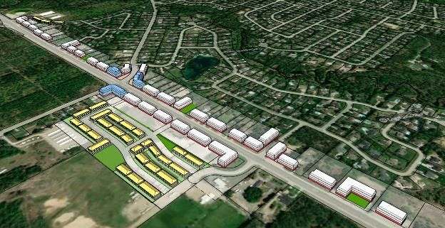
TABLE OF                  1       INTRODUCTION ............................................. 1
                          1.1     Study Area...................................................................... 2
CONTENTS                  1.1.1   Bayfield Centre Character Area .................................................... 3
                          1.1.2   Bayfield South Character Area ..................................................... 4
                          1.1.3   Bayfield North Character Area ...................................................... 5
                          1.2     Study Objectives ........................................................... 1
                          1.3     Study Approach ............................................................. 1

                          2       POLICY CONTEXT ......................................... 2
                          2.1     Provincial Policy Statement, 2020 ............................... 2
                          2.2     Growth Plan for the Greater Golden Horseshoe,
                                  2020, Consolidated ........................................................ 2
                          2.3     County of Simcoe Official Plan .................................... 3
                          2.4     Township of Springwater Official Plan ....................... 4
                          2.5     Midhurst Secondary Plan ............................................. 5
                          2.5.1   Study Area Focus ......................................................................... 7
                          2.5.2   Study Area Land Use Designations .............................................. 7
                          2.5.3   Urban Design Guidelines .............................................................. 8
                          2.6     Township of Springwater Zoning By-law .................... 9

                          3       STUDY CONTEXT: EXISTING CONDITIONS
                                  ...................................................................... 13
                          3.1     Existing Land Uses .....................................................13
                          3.1.1   Bayfield South Character Area ................................................... 13
                          3.1.2   Bayfield Centre Character Area .................................................. 14
                          3.1.3   Bayfield North Character Area .................................................... 15
                          3.2     Built Form and Streetscape ........................................15
                          3.2.1   Bayfield South Character Area ................................................... 16
                          3.2.2   Bayfield Centre Character Area .................................................. 16
                          3.2.3   Bayfield North Character Area .................................................... 18
                          3.3     Recent and Proposed Developments ........................19

Bayfield Corridor Study
February 2021                                                                                                             Page ii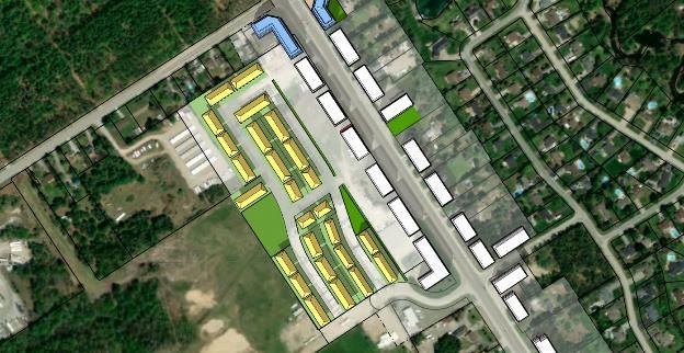
3.4     Transportation .............................................................21
                          3.4.1   Transit ........................................................................................ 21
                          3.4.2   Active Transportation .................................................................. 21
                          3.4.3   Access Locations........................................................................ 23
                          3.4.4   Parking ....................................................................................... 23
                          3.5     Infrastructure and Services ........................................23
                          3.6     Natural Areas and Environmental Conditions ..........24

                          4       OPPORTUNITIES & CHALLENGES............. 25
                          4.1     Opportunities ...............................................................25
                          4.1.1   Land Use .................................................................................... 25
                          4.1.2   Urban Design.............................................................................. 25
                          4.1.3   Transportation ............................................................................ 26
                          4.1.4   Access ........................................................................................ 26
                          4.1.5   Market Demand .......................................................................... 27
                          4.2     Challenges ...................................................................28
                          4.2.1   Land Uses .................................................................................. 28
                          4.2.2   Urban Design.............................................................................. 28
                          4.2.3   Transportation ............................................................................ 28
                          4.2.4   Access ........................................................................................ 29
                          4.2.5   Market Demand .......................................................................... 29

                          5       VISION, GUIDING PRINCIPLES &
                                  RECOMMENDATIONS ................................. 30
                          5.1     Vision for the Bayfield Street Corridor ......................30
                          5.2     Guiding Principles & Objectives ................................30
                          5.3     Proposed Corridor Demonstration Plan ...................32
                          5.3.1   Corridor Character Areas............................................................ 32
                          5.3.2   Development Assumptions ......................................................... 32
                          5.3.3   Conceptual Demonstration Plans ............................................... 33
                          5.3.4   Overall Corridor Plan View & Character Sub-Areas ................... 34
                          5.3.5   Centre Character Area ............................................................... 34

Bayfield Corridor Study
February 2021                                                                                                                   Page iii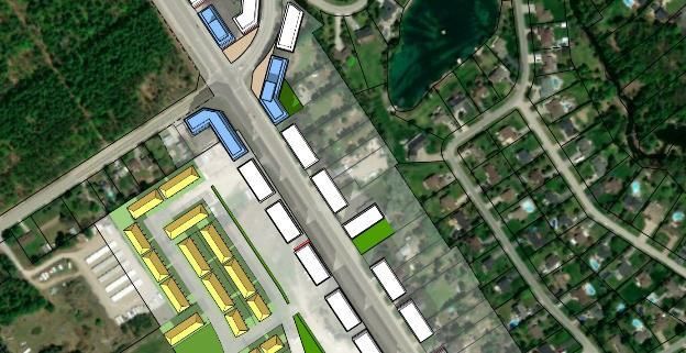
5.3.6    Centre Character Area – Area ‘A’ ............................................... 37
                          5.3.7    Centre Character Area – Area ‘B’ ............................................... 37
                          5.3.8    Centre Character Area – Area ‘C’ ............................................... 39
                          5.3.9    Centre Character Area – Area ‘D’ ............................................... 41
                          5.3.10   Centre Character Area – Area ‘E’ ............................................... 43
                          5.3.11   Centre Character Area – Area ‘F’ ............................................... 45
                          5.3.12   Centre Character Area – Area ‘G’ ............................................... 46
                          5.3.13   South Character Area – Area ‘H’ Concept Plan .......................... 48
                          5.3.14   North Character Area – Area ‘I’ .................................................. 49
                          5.4      Bayfield Corridor Conceptual Streetscape ...............50

                          6        POLICY DIRECTION .................................... 52
                          6.1      Amendments to Zoning By-law 5000 ........................52
                          6.2      Amendments to Midhurst Secondary Plan ...............53
                          6.2.1    Provision of Urban Design Guidelines ........................................ 53

                          7        CONCLUSION .............................................. 54

Bayfield Corridor Study
February 2021                                                                                                      Page iv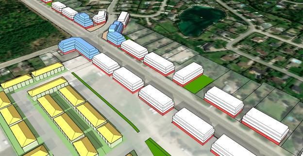
TABLES
                          TABLE 1: SUMMARY OF RELEVANT ZONING BY-LAW
                                        5000 STANDARDS............................10
                          TABLE 2: DEVELOPMENT APPLICATIONS IN THE
                                        BAYFIELD CORRIDOR AREA -
                                        SUMMARY ........................................20

                          FIGURES
                          FIGURE 1: STUDY AREA ...............................................2
                          FIGURE 2: BAYFIELD CENTRE CHARACTER AREA ..3
                          FIGURE 3: BAYFIELD SOUTH CHARACTER AREA ....4
                          FIGURE 4: BAYFIELD NORTH CHARACTER AREA ....5
                          FIGURE 5: TOWNSHIP OF SPRINGWATER WITHIN
                                        GREATER GOLDEN HORSESHOE
                                        (SCHEDULE 8: SIMCOE SUB-AREA) 3
                          FIGURE 6: STUDY AREA WITHIN MIDHURST
                                        SETTLEMENT AREA (MIDHURST
                                        SECONDARY PLAN, 2008) ................6
                          FIGURE 7: LAND USE DESIGNATIONS IN MIDHURST
                                        (MIDHURST SECONDARY PLAN,
                                        2008) ....................................................8
                          FIGURE 8: EXISTING ZONING PROVISIONS WITHIN
                                        THE STUDY AREA ..............................9
                          FIGURE 9: DEVELOPMENT ACTIVITY IN MIDHURST
                                         ...........................................................19
                          FIGURE 10: NEIGHBOURHOOD COLLECTOR ROAD
                                        WITH BIKE LANES
                                        (NEIGHBOURHOOD DESIGN PLAN,
                                        2014) ..................................................22
                          FIGURE 11: EXISTING AND PROPOSED ROAD/TRAIL
                                        NETWORK IN MIDHURST
                                        (MIDHURST SECONDARY PLAN,
                                        2008) ..................................................22
                          FIGURE 12: CHARACTER AREAS, CORRIDOR
                                        STUDY BOUNDARY AND SUB-
                                        AREAS ...............................................32
                          FIGURE 13: CORRIDOR VIEW AND CHARACTER
                                        SUB-AREAS ......................................34
                          FIGURE 14: OVERALL CONCEPTUAL MASSING
                                        PLAN FOR CENTRE CHARACTER
                                        AREA .................................................34
                          FIGURE 15: COMMUNITY FOCUS INTERSECTION
                                        CONCEPT – PLAN VIEW..................35

Bayfield Corridor Study
February 2021                                                                                            Page v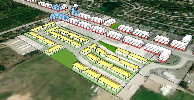
FIGURE 16: COMMUNITY FOCUS INTERSECTION
                                        CONCEPT - VIEW LOOKING
                                        SOUTHWEST ....................................36
                          FIGURE 17: COMMUNITY FOCUS INTERSECTION
                                        CONCEPT - VIEW LOOKING
                                        NORTHEAST .....................................36
                          FIGURE 18: CONCEPTUAL PLAN VIEW - AREA 'B'...38
                          FIGURE 19: CONCEPTUAL MASSING VIEW - AREA
                                        ‘B’ .......................................................38
                          FIGURE 20: CONCEPTUAL PLAN VIEW - AREA ‘C’ ..40
                          FIGURE 21: CONCEPTUAL MASSING VIEW - AREA
                                        ‘C’ .......................................................40
                          FIGURE 22: CONCEPTUAL PLAN VIEW - AREA ‘D’ ..42
                          FIGURE 23: CONCEPTUAL MASSING VIEW - AREA
                                        ‘D’ .......................................................42
                          FIGURE 24: CONCEPTUAL MASSING VIEW LOOKING
                                        EAST - AREA ‘D’ ...............................43
                          FIGURE 25: CONCEPTUAL PLAN VIEW - AREA ‘E’ ..44
                          FIGURE 26: CONCEPTUAL MASSING VIEW - AREA
                                        ‘E’ .......................................................44
                          FIGURE 27: CONCEPTUAL PLAN VIEW - AREA 'F' ...45
                          FIGURE 28: CONCEPTUAL MASSING VIEW - AREA
                                        ‘F’ .......................................................46
                          FIGURE 29: CONCEPTUAL PLAN VIEW - AREA 'G’ ..47
                          FIGURE 30: CONCEPTUAL MASSING VIEW - AREA
                                        'G' .......................................................47
                          FIGURE 31: CONCEPTUAL PLAN VIEW – AREA ‘H’ .48
                          FIGURE 32: CONCEPTUAL PLAN VIEW – AREA ‘I’ ...50
                          FIGURE 33: CONCEPTUAL MASSING VIEW - AREA 'I'
                                         ...........................................................50
                          FIGURE 34: BAYFIELD CORRIDOR CONCEPTUAL
                                        STREETSCAPE ................................51

                          APPENDICES
                          APPENDIX ‘A’ - BAYFIELD CORRIDOR URBAN DESIGN GUIDELINES

Bayfield Corridor Study
February 2021                                                                                            Page vi
1 INTRODUCTION
The Township of Springwater (the “Township”) is undertaking an Official Plan Review (OPR), which offers
an opportunity to evaluate the Official Plan’s existing policy framework related to managing growth,
improving transportation systems, capitalizing on economic development opportunities, and protecting and
enhancing natural heritage features and water resources over the next 25 years. The OPR will address the
opportunities and challenges of planning and building in the Township and will result in a new Official Plan
that implements Provincial and County of Simcoe policies that have been introduced or amended recently.

The Township’s Official Plan has undergone a number of years, including Secondary Plans for the Midhurst,
Hillsdale, Centre Vespra, and the Snow Valley Settlement Areas. Due to delays attributed to ongoing policy
revisions at the Provincial level and the County Official Plan conformity/update, the Official Plan has not
undergone a major revision/update in nearly 20 years. The OPR project stems from the need for local
planning documents to evolve in-parallel with the issues and matters of upper-tier municipal and Provincial
interests, in order to provide a consistent policy framework that guides growth and development. As a result,
the Township of Springwater Official Plan is being reviewed to ensure consistency with provincial policy,
and conform to the updated Growth Plan for the Greater Golden Horseshoe (2020, Consolidated), the
Provincial Policy Statement (2020), and specifically the Simcoe Sub-Area, as well as the new County of
Simcoe Official Plan (2016).

As part of this process, the Township has
undertaken the Bayfield Street Corridor
Study to evaluate the potential intensification
opportunities for this important community
area and spine road, to align with recent
updates in Provincial and County policies.
The intersection of Bayfield Street and Snow
Valley Road is an important intersection in
the Midhurst settlement area, and along with
Bayfield Road, serves as appropriate
locations to promote sensitive intensification.
The intensification, in keeping with the
Midhurst Secondary Plan, will be achieved
through      mixed-use      residential    and
commercial uses and specific urban design
guidelines will be required to implement the
vision for the Corridor. This Study will:

     •    Clearly define the Corridor boundary;

     •    Outline the Study purpose and approach;

     •    Review the Provincial, County and Township policy context:

     •    Analyze the existing conditions of the Corridor and its adjacent areas;

     •    Identify opportunities and challenges for the study area: and,

     •    Provide final recommendations, policy direction and urban design guidelines to achieve the goals
          and objectives of the Bayfield Street Corridor.

Bayfield Corridor Study
February 2021                                                                                           Page 1
1.1 STUDY AREA
The Bayfield Street Corridor study area is located in the Midhurst settlement area, spanning Bayfield Street
for the entirety of the settlement area. The study area is shown below, highlighted in purple in Figure 1.

                                                                                       Figure 1: Study Area

The study area covers distinct areas along the Bayfield Street Corridor of Midhurst, including parts of
Midhurst Village, the intersection of Bayfield Street and Snow Valley Road and environmental protection
areas. As such, the Bayfield Street Corridor has been divided into three Character Areas to reflect the
existing conditions and to provide a framework that addresses each of the areas. Each of the character
areas have a distinct context with respect to existing land uses. The North and South character areas are
predominantly comprised of surrounding low density and estate residential housing. The Centre character
area is distinct from the other areas as it includes a range of low density residential uses as well as a
range of scale and type of commercial, retail, and employment uses. The low density residential buildings
generally front onto Bayfield Street and some include commercial activities.

The location and general description and characteristics of the three character areas are discussed below.
A more detailed description of their existing conditions is discussed in Section 3 of this Study.

Bayfield Corridor Study
February 2021                                                                                          Page 2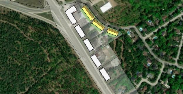
1.1.1 BAYFIELD CENTRE CHARACTER AREA

                              Character                                                            Character
                              Area                                                                     Area
                              Boundary                                                             Boundary

                                                                       Figure 2: Bayfield Centre Character Area

     •    Bound by Carson Road / Paddy Dunn’s Circle to the south, and the intersection of Highway 26 /
          County Road 27 to the north

     •    Existing uses include commercial, residential, outside storage, institutional, and agricultural

     •    Adjacent uses include open space (Doran Park), agricultural, institutional, outside storage and
          rural residential

Bayfield Corridor Study
February 2021                                                                                               Page 3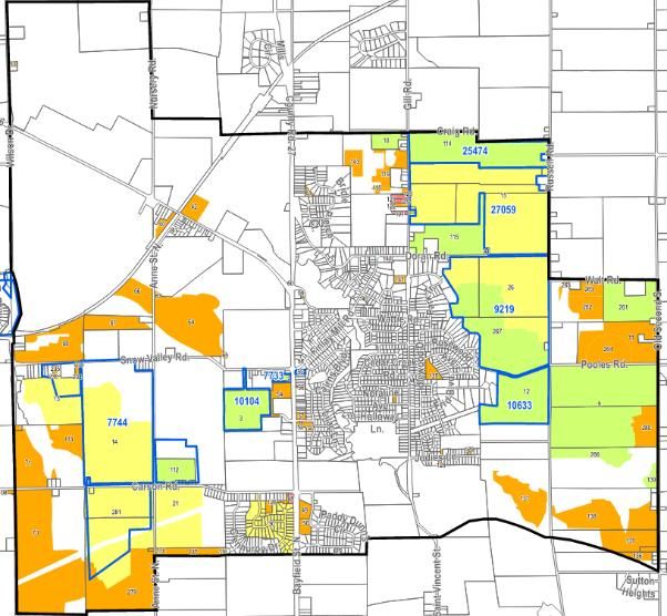
1.1.2 BAYFIELD SOUTH CHARACTER AREA

                                   Character
                                       Area
                                   Boundary

                                                                    Figure 3: Bayfield South Character Area

     •    Bound by Carson Road / Paddy Dunn’s Circle to the north

     •    Existing uses include commercial

     •    Adjacent uses include residential and commercial

Bayfield Corridor Study
February 2021                                                                                         Page 4
1.1.3 BAYFIELD NORTH CHARACTER AREA
Character
Area
Boundary
Figure 4: Bayfield North Character Area
• Bound by the intersection of Highway 26 / County Road 27 to the south
• Existing uses include residential and agricultural
• Adjacent uses include open space (including Doran Park), agricultural and residential
Bayfield Corridor Study
February 2021 Page 51.2 STUDY OBJECTIVES
The purpose of this Study is to serve as a land use analysis, a demonstration plan of the permitted mixed-
uses as indicated in the Midhurst Secondary Plan and to provide further urban design criteria to guide future
land use and built form changes for the Bayfield Street Corridor. The objectives of the Study include:
• To support the major intersection of Bayfield Street/Snow Valley Road/Finlay Mill Road to
establish a community focal point and support the Community Hub on the Hasty Tract property;
• Identify land uses considered appropriate for the high order community focus area;
• Provide general time horizons to achieve the vision for the Corridor;
• Accommodate a mix of retail, commercial and residential uses scaled to pedestrians and cyclists
with urban cross sections;
• Establish appropriate intensification and higher density development forms;
• Consolidate and limit the number of vehicular access locations; and
• Further develop urban design guidelines specific to the Corridor in addition to the Secondary Plan
guidelines.
The analysis and resulting demonstration plan for the Corridor will result in the development of a planning
framework for the Corridor, inclusive land use designations and policies, and associated urban design
guidelines.
1.3 STUDY APPROACH
The approach for completing the Bayfield Street Corridor Study involved the following:
• An overview of the existing policy context, including Provincial, upper-tier and lower-tier documents;
• A review of the existing physical context such as existing land uses, built form and streetscape
within the study area and its immediate surroundings;
• Identifying opportunities and challenges regarding land use and urban design within the study area;
• Developing recommendations and a land use framework to encourage the Corridor’s objectives
and vision; and
• Proposing an implementation strategy, such as Official Plan and Zoning By-law amendments and
developing an Urban Design Checklist, to achieve the recommended vision for the Corridor.
This approach also included consultation with Township staff, and will be further informed by Council and
public comments as well as input that may be received from other stakeholders.
Bayfield Corridor Study
February 2021 Page 12 POLICY CONTEXT
An overview of the policy context, including Provincial, County and Township planning policies, was
completed to demonstrate how each document supports the objectives of the Corridor Study. This review
also identified any gaps between the local policies and upper tier or provincial policies.
2.1 PROVINCIAL POLICY STATEMENT, 2020
The current Provincial Policy Statement (the “PPS”) came into effect on May 1,
2020 and provides policy direction on matters of Provincial interest related to
land use planning and development. In accordance with Section 3(5) of the
Planning Act, all land use decisions are required to be consistent with the PPS.
A central policy direction of the PPS is to create strong, healthy communities
through efficient development and land use patterns.
Policies under section 1.1.3, Settlement Areas, state that settlement areas,
which are comprised of urban and rural areas, shall be the focus of growth and
development. This will be achieved by ensuring that land use patterns within
settlement areas are based on a range of uses and opportunities for
intensification and redevelopment. Policy 1.1.3.2 further promotes density and
a mix of land uses to efficiently use infrastructure and public service facilities,
support transit and active transportation, and avoid uneconomical expansion. Policy 1.1.3.3 promotes
opportunities for transit-supportive development, such as accommodating a significant supply and range of
housing options through intensification and redevelopment where this can be accommodated. It takes into
account existing building stock or areas, including brownfield sites, and the availability of suitable existing
or planned infrastructure and public service facilities required to accommodate projected needs. These
policies also state that appropriate development standards should be promoted which facilitate
intensification, redevelopment and compact form, while avoiding or mitigating risks to public health and
safety (policy 1.1.3.4). Policy 1.6.7.4 encourages efficient land use pattern, density and mix of uses to
minimize the length and number of vehicle trips and support current and future use of transit and active
transportation.
The study area has been identified as a focus area for the Midhurst community, and provides an opportunity
for further enhancement by implementing Provincial policies as they relate to intensification within existing
settlement areas, encouraging a mix of uses and promoting active transportation and public transit.
2.2 GROWTH PLAN FOR THE GREATER GOLDEN
HORSESHOE, 2020, CONSOLIDATED
A Place to Grow: Growth Plan for the Greater Golden Horseshoe (“Growth
Plan”) came into effect on May 16, 2019 and was consolidated on August 28,
2020. The Growth Plan contains policies regarding population and
employment projections that form the basis for managing growth in
municipalities within the Greater Golden Horseshoe Area, including the
Township of Springwater (shown in Figure 5). The Growth Plan guides
decisions on a wide variety of issues, including transportation, infrastructure
planning, land use planning, urban form, housing, natural heritage and
resource protection in the interest of promoting economic prosperity,
increasing housing supply, creating jobs and building communities.
Bayfield Corridor Study
February 2021 Page 2For the Township of Springwater, the Growth
Plan projects a population growth of 24,000
residents and 5,600 jobs to the year 2031. The
Bayfield Street Corridor is located within the
Midhurst Settlement Area, which has been
identified by the Township as one of
Springwater’s two major community focus
areas. The Growth Plan defines settlement
areas as built up areas where development is
concentrated and which have a mix of land
uses, and lands which have been designated in
an official plan for development in accordance
with the policies of the Plan.
Policy 2.2.1.2. a) states that the vast majority of
growth will be directed to settlement areas that:
i. have a delineated built boundary;
ii. have existing or planned municipal water
and wastewater systems; and
iii. can support the achievement of complete
communities.
Given the forecasted population and
employment growth for the Township, and the
study area being located within a settlement
area, the Growth Plan’s policies relating to
directing growth within settlement areas with
Figure 5: Township of Springwater within Greater Golden existing infrastructure are supported by the
Horseshoe (Schedule 8: Simcoe Sub-Area) objectives of this Study. By establishing the
Bayfield Street Corridor as an intensification
corridor with a mixed use residential and commercial land uses, urban design guidelines and proposed
streetscape enhancements, this provides an opportunity to implement the overarching goals of the Growth
Plan and other Provincial policies; namely, to achieve complete communities, a thriving economy, a clean
and healthy environment and social equity.
2.3 COUNTY OF SIMCOE OFFICIAL PLAN
The County of Simcoe Official Plan (2008), was adopted by County Council in November 2008, and
appealed to the Ontario Municipal Board (the “OMB”) in December 2009. The OMB approved the Official
Plan in December 2016. The County Official Plan conforms to the PPS and Growth Plan, and is responsible
for land use planning decisions of County interest, such as setting intensification and density targets.
In the Township of Springwater, the County has set a minimum intensification target of 15% of all new
residential units occurring annually be developed within the built boundaries of settlement areas by the year
2015 and for each year thereafter (policy 3.5.24). As noted, the study area is located within the Midhurst
settlement area.
The County’s objectives for settlement areas, as stated under Section 3.5 of the Official Plan, are the
following:
• Policy 3.5.1
To focus population and employment growth and development within settlements, with particular
emphasis on primary settlement areas, in accordance with the policies of this Plan.
Bayfield Corridor Study
February 2021 Page 3• Policy 3.5.2
To develop a compact urban form that promotes the efficient use of land and provision of water,
sewer, transportation, and other services.
• Policy 3.5.3
To develop mixed use settlements as strong and vibrant central places and to create healthy
settlements and communities that are sustainable.
• Policy 3.5.4
To promote development forms and patterns which minimize land consumption and servicing costs.
Further, policy 3.5.26 states that settlements, and the downtowns and main streets of primary settlement
areas, shall be promoted as focal points for residential, commercial, and institutional uses, through the
following:
• Establishing safe and pleasant pedestrian environments which encourage movement by foot and
bicycle and transit;
• Protection of heritage buildings and structures;
• Development of attractive streetscapes;
• Encouragement of downtown economic development initiatives; and
• Development of a range of housing types and costs.
Under policy 3.5.30 of the Plan, the County states that a range of types of housing, including detached,
semi-detached, townhouse, and apartment units, be provided, along with a mix of affordable housing, to
meet a variety of housing needs. Further, the County has set a target that a minimum of ten percent (10%)
of all new housing units created each year will be affordable housing units (policy 4.3.9).
Given the County’s direction on intensification targets and the type of intensification that should be
implemented within settlement areas, this supports the objectives of the Corridor Study. With regards to
promoting intensification and development within built up areas, mixed use residential and commercial uses
are envisioned along with housing typologies that increase the range of variety and tenure in the Midhurst
community. These uses will be supported and guided by and urban design guidelines and proposed
streetscape enhancements.
2.4 TOWNSHIP OF SPRINGWATER OFFICIAL PLAN
The Township of Springwater’s Official Plan outlines the existing objectives and
policies with respect to growth and development of urban lands, the protection
of agricultural lands, the conservation of natural heritage areas, and the
provision of necessary infrastructure. The Township’s current Official Plan took
effect on February 19, 1998, with a planning horizon to the year 2016. As such,
the Township is currently in the process of updating the Official Plan in
consideration of recent provincial legislation, policies and plan, and the new
County Official Plan.
The Official Plan states that most growth in the Township is to be directed to
urban settlement areas, which refers to Springwater’s two major communities
and six minor communities (S.5.1.3). The Plan states that the major
Bayfield Corridor Study
February 2021 Page 4communities of Midhurst and Elmvale are preferred locations to accommodate projected growth in the
Township, due to the characteristics of these settlement areas, as well as the wide range of existing
municipal services and facilities available in these communities.
Conforming with Provincial and upper-tier plans, the Township of Springwater Official Plan states the
following goals:
• To ensure the maintenance, protection and enhancement of natural heritage features;
• To preserve and protect prime agricultural areas;
• To encourage business investment and to foster a positive investment climate in the Township;
• To ensure that all land use planning decisions have regard for the conservation of significant built
heritage features, cultural heritage landscapes and archaeological resources;
• To create efficient, cost effective development and land use patterns;
• To promote the development of strong and economically viable urban communities;
• To preserve and protect the high quality of life in Springwater Township for the long term future;
• To direct new growth to existing urban settlement areas to encourage and provide every opportunity
to create a vibrant community planning context in our villages and small urban places; and
• To ensure that all new development shall avoid creating adverse circumstances with existing and
future development.
Specific to the study area, Bayfield Street North (Highway 26/County Road 27) is recognized as a major
transportation facility where new land uses in the area must be properly planned in regard to access,
function and high quality of use and design (policy 8.6.1.9). Further, the Official Plan states that significant
commercial/light industrial mixed-use development be directed to this area (policy 8.6.1.8).
To help achieve these goals, a Secondary Plan was developed outlining specific land use and urban design
guidelines for the Midhurst Settlement Area.
2.5 MIDHURST SECONDARY PLAN
The Midhurst Secondary Plan (the “Secondary Plan”) articulates the land use policies set forth in the Official
Plan for the Midhurst settlement area. The Secondary Plan was adopted by Council in November of 2008
as OPA 38, and approved by the County of Simcoe in 2011. However, it was appealed to the Ontario
Municipal Board by several parties. The consolidated version of the Plan was approved on October 2, 2018.
The Midhurst settlement area is planned to accommodate growth of approximately 10,000 new dwellings,
plus additional growth within mixed use and commercial designations. Three new neighbourhoods were
established as part of this Plan, where the majority of growth would occur. The study area is located in the
center of the settlement area, outside of the three new neighbourhoods, as shown in Figure 6.
Bayfield Corridor Study
February 2021 Page 5Bayfield Street Corridor
Figure 6: Study Area within Midhurst Settlement Area (Midhurst Secondary Plan, 2008)
The principles of the Secondary Plan are based on achieving Provincial and Township policies with respect
to developing sustainable land use patterns, conserving natural and cultural heritage features, protecting
public health and safety, promoting active transportation opportunities and achieving minimum
development densities. Further, the Plan is based on a community structure that is diverse in use and
population, is scaled to the pedestrian, can accommodate transit as well as private automobiles and has a
well-defined and high quality public realm, roads and Greenlands system. Structurally, the principles of the
Plan include:
• Providing a diversity of housing types ranging from single detached houses to low rise apartment
buildings to achieve densities anticipated in municipal and provincial policy;
• Plan for a density of development that will help to promote more affordable forms of housing, and
will support the provision of public transit and a range of commercial activities; and
• Provide a mix of uses so that residents have the choice to work, shop and enjoy community facilities
within the Midhurst community.
Bayfield Corridor Study
February 2021 Page 62.5.1 STUDY AREA FOCUS
It is the intent of the Secondary Plan to promote sensitive intensification within the Corridor with a mixture
of uses, including higher density forms of housing. The Intersection of Bayfield Street and Snow Valley
Road is identified as a major community focus for the Midhurst community, which is intended as the location
for higher order retail and other employment generating uses, including community facilities.
2.5.2 STUDY AREA LAND USE DESIGNATIONS
For the Bayfield Street Corridor, the Secondary Plan identifies lands within the study area as
Commercial/Mixed Use. The intersection of Bayfield Street, Highway 26 and County Road 27 within the
study area is identified for Future Intersection Improvements. Lands designated as Environmental
Protection Area I and Environmental Protection Area II are located adjacent to the study area.
The following outlines permitted uses and regulations within land use designations established in the Plan:
5.1 Commercial / Mixed Use Designation
• The principal uses permitted within the Commercial/Mixed Use designation include all existing uses
and a variety of business, retail, service, institutional, open space and utility uses.
• Residential uses may be permitted within the Commercial/Mixed Use designation provided they
are wholly integrated as part of mixed use development.
• Maximum height of any building shall be 6 storeys or 22 metres, whichever is less.
• All buildings will be oriented to face the front of the site and on corner lots face the higher order
roadway.
• The number of access points to public roads shall be minimized and the use of a joint of shared
access point is encouraged.
5.4 Environmental Protection Area I
• Any proposed development within, or adjacent to the Environmental Protection Area I shall be
required to prepare an Environmental Impact Study.
5.5 Environmental Protection Area II
• Prior to any lands being considered for development within or abutting any area within the
Environmental Protection Area II, an Environmental Impact Study is to be undertaken.
Bayfield Corridor Study
February 2021 Page 7Bayfield Street Corridor
Figure 7: Land Use Designations in Midhurst (Midhurst Secondary Plan, 2008)
2.5.3 URBAN DESIGN GUIDELINES
To achieve the Plan’s objectives, it is premised on high quality urban design. As such, the urban design
guidelines include measures to ensure the following:
• The provision of a clearly defined public realm;
• A standardized and highly interconnected pattern of lotting for development blocks;
• Consistent built form;
• Safety, accessibility, and comfort in the pedestrian environment;
• Energy efficient neighbourhood and building design; and
• Support for active transportation including transit services throughout the community.
As it relates to the adjacent environmental features within the Corridor, Section 6.2.2 (Views and Focal
Points) of the UDGs state the following:
“The preservation, enhancement and creation of significant views and focal points shall be
encouraged by preserving and enhancing views to natural heritage features, including woodlots,
cultural heritage landscapes, water bodies, and across parks and open spaces.”
Bayfield Corridor Study
February 2021 Page 8Policies within the Midhurst Secondary Plan align with the objectives of the Study as it promotes the Corridor
as an area for sensitive intensification, mixed use development, denser housing typologies and urban
design features.
2.6 TOWNSHIP OF SPRINGWATER ZONING BY-LAW
The Township of Springwater Comprehensive Zoning By-law 5000 was approved by Council in 2003 and
by the OMB in 2004. The approximate boundary of the Corridor study area is shown in Figure 8 (purple
outline) and indicates that it is comprised of a variety of land use zoning designations. They are shown in
the figure below and are indicated, with general zoning criteria and standards in Table 1, that follows.
A
A
Corridor Study
Area Boundary
Figure 8: Existing Zoning Provisions within the Study Area
Bayfield Corridor Study
February 2021 Page 9Table 1: Summary of relevant Zoning By-law 5000 standards
ZONE RELEVANT PERMITTED USES KEY LOT & BUILDING STANDARDS
RESIDENTIAL (R1) Residential Uses Minimum Lot Area – 555 sq. m. to 1855 sq.
m.
— Single detached dwelling
Minimum Lot Frontage – 18 m to 30 m
Non-Residential Uses Minimum Front Yard Depth – 6 m to 9 m
— Bed and breakfast Minimum Rear Yard Depth – 7.5 m
Minimum Interior Side Yard Width – 1.2 m
— Home occupation
to 3 m
Minimum Exterior Side Yard Width – 6 m to
9m
Maximum Lot Coverage – 20% to 35%
Minimum Dwelling Unit GFA – 100 sq. m.
Maximum Building Height – 11 m
GENERAL Residential Uses Minimum Lot Area – 930 sq. m. to 1390 sq.
COMMERCIAL (CG) m.
— Dwelling unit in a non-residential
building Minimum Lot Frontage – 23 m to 30 m
Minimum Front Yard Depth – 7.5-9 m
Non-Residential Uses
Minimum Rear Yard Depth – 7.5 m
— Retail store or commercial use Minimum Interior Side Yard Width – 4 m to
— Personal service shop 4.5 m
Minimum Exterior Side Yard Width – 9 m
— Government, business or
professional office Maximum Lot Coverage – 40%
Maximum Building Height –11m
— Clinic
Minimum Setback from Residential Zone –
— Service repair shop 9m
— Restaurant Minimum GFA (Residential Dwelling) – 42
sq. m
— Commercial recreational
establishments
— Day nursery/nursery school
— Public use
HIGHWAY Residential Uses Minimum Lot Area – 790 sq. m. to 1390 sq.
COMMERCIAL (CH) m.
— Attached accessory dwelling
Minimum Lot Frontage – 20 m to 30 m
Non-Residential Uses Minimum Front Yard Depth – 6 m to 9 m
— Motor vehicle service station Minimum Rear Yard Depth – 3.5 m to 7.5 m
Minimum Interior Side Yard Width – 3.5 m
— Motor vehicle repair garage
to 4.5 m
— Motor vehicle sales or rental Minimum Exterior Side Yard Width – 6 m to
establishment
9m
— Food confectionary sales Maximum Lot Coverage – 30% to 40%
— Service repair shop Maximum Building Height – 11 m
Bayfield Corridor Study
February 2021 Page 10ZONE RELEVANT PERMITTED USES KEY LOT & BUILDING STANDARDS
— Restaurant Minimum Landscaped Open Space – 10%
— Building supply outlet Minimum Setback from Residential Zone –
9m
— Recreational trailer sales,
Minimum GFA (Accessory Dwelling) – 42
service and display
sq. m
— Fruit and vegetable market
— Public use
GENERAL Residential Uses Minimum Lot Area – 700 sq. m. to 1855 sq.
INDUSTRIAL/ m.
— Attached accessory dwelling
OUTSIDE Minimum Lot Frontage – 30 m
STORAGE (MO) Non-Residential Uses Minimum Front Yard Depth – 10 m to 15 m
— Motor vehicle body shop or Minimum Rear Yard Depth – 10 m (15 m
repair garage where the lot line abuts a Residential Zone)
— Building supply outlet Minimum Interior Side Yard Width – 4 m to
6 m (15 m where the lot line abuts a
— Yard for storage, display or sale
of goods Residential Zone)
Minimum Exterior Side Yard Depth – 9 m
Maximum Lot Coverage – 40%
Maximum Building Height – 11 m
INSTITUTIONAL (I) Residential Uses Minimum Lot Area – N/A (1855 sq. m.
where the lot is not served by a public water
— Attached accessory dwelling
and sanitary sewer system)
Non-Residential Uses Minimum Lot Frontage – N/A (30 m where
— Clinic the lot is not served by a public water and
sanitary sewer system)
— Hospital
Minimum Front Yard Depth – 6 m to 9 m
— Nursing home Minimum Rear Yard Depth – 7.5 m
— Home for the aged/senior Minimum Interior Side Yard Width – 4 m to
citizens home 7.5 m (3 m where the lot line abuts a
— Place of worship Commercial or Institutional Zone, 15 m
— Community centre where the lot line abuts a Residential Zone)
Minimum Exterior Side Yard Width – 6 m to
— School
9m
— Public recreational use Maximum Lot Coverage – 30% to 40%
— Government or civic building Maximum Building Height – 11 m
— Museum
AGRICULTURAL (A) Residential Uses Minimum Lot Area – 35 ha.
Minimum Lot Frontage – 150 m
— Single detached dwelling
Minimum Yard (All) – 30 m
— Accessory single detached Maximum Height (Non-Agricultural) – 11m
dwelling
Maximum Height (Agricultural) – N/A
Non-Residential Uses
Bayfield Corridor Study
February 2021 Page 11ZONE RELEVANT PERMITTED USES KEY LOT & BUILDING STANDARDS
— Agricultural use
— Bed and breakfast
— Home occupation
— Passive outdoor recreation use
— Public use
The existing zoning regulations within the study area do not align with the land use designations outlined
in the Midhurst Secondary Plan, the objectives for the intersection of Bayfield Street and Snow Valley Road,
nor the overall objectives of the Bayfield Street Corridor Study as they relate to establishing intensification,
higher density development and accommodating a mix of commercial and residential uses, including a
range of housing typologies. Although there can be the ‘grandfathering” of existing zoned uses, the ZBL
will need to be updated to not only reflect the uses as outlined in the Midhurst Secondary Plan but also the
amendment of it as a result of this Study and the review of the Springwater Official Plan Review.
Bayfield Corridor Study
February 2021 Page 123 STUDY CONTEXT: EXISTING CONDITIONS The study area is located within Midhurst, which has been identified as one of the Township’s major settlement areas. This section describes the existing conditions within the study area, including an examination of existing land uses, built form and streetscape in each of the identified Character Areas. This section also discusses recent and proposed developments, transportation conditions, infrastructure and services, as well as natural areas and environmental conditions within the Corridor. 3.1 EXISTING LAND USES There are currently a range of existing uses within the study area, including low density single-detached residential dwellings and estate style homes on large lots, a variety of commercial uses, auto servicing, outside storage and open space. Within the study area, there are just over 50 properties that front onto the east side of Bayfield Street, and just over 10 properties that front onto the west side of Bayfield Street. The three neighbourhoods along Carson Road, Doran Road, and Pooles Road within Midhurst, where the majority of future growth will occur, are located to the west and east of the study area, as shown in Figure 11 in Section 3.4.2 of the Study. Surrounded by these neighbourhoods and along a major roadway, the Bayfield Street Corridor is well suited to provide a focused mixed-use corridor that serves as a central transition area between the western neighbourhood of Carson Road and the eastern neighbourhoods of Doran Road, and Pooles Road. 3.1.1 BAYFIELD SOUTH CHARACTER AREA The Bayfield South Character Area extends from the southern boundary of the Midhurst Settlement Area north to Carson Road, which is designated as Midhurst Village in the Secondary Plan. This character area is generally represented by low density residential uses and estate properties that are visible from but do not front onto Bayfield Street. At the northern limit of the area there are commercial uses with offices, services and a medical facility. It is also comprised of woodland and wetland areas that are located within this character area. Directly south and adjacent to the character area are lands designated for agricultural uses. Bayfield Corridor Study February 2021 Page 13
3.1.2 BAYFIELD CENTRE CHARACTER AREA
The Bayfield Centre Character Area extends north from Carson Road to the intersection of Bayfield Street,
Highway 26 & County Road 27. It is located in the centre of the study area, is the most significant contiguous
portion of the Corridor and has the greatest potential for continuous built form and intensification comprised
of mixed use development that is scaled to pedestrians and active transportation. The existing land uses
within this character area include a mixture of commercial, low density residential, institutional and outdoor
storage. There are also adjacent and surrounding lands designated as open space, agricultural, and
environmental protection.

The Hydro One Midhurst Transmission System is located at the southern boundary of the area. Across
from the transmission station are environmentally protected lands. Single-detached homes, with various
front yard setbacks, are interspersed within the character area alongside commercial uses such as gas
stations and auto shops, retail, rental services, radio station, a truck dealership and commercial strip mall
uses.

The intersection of Bayfield Street and Snow Valley Road currently contains commercial uses on the
northeast and southwest corners, low density residential uses on the southeast corner and open space on
the northwest corner.

To the east of this intersection is Finlay Mill Road, which is an established residential and mixed-use area.
Finlay Mill Road connects Bayfield Street to the interior of Midhurst, the historic part of Midhurst and towards
the new neighbourhoods of Doran Road and Pooles Road, which are designated as low, medium and high

Bayfield Corridor Study
February 2021                                                                                             Page 14
density residential. The west side of this intersection along Snow Valley Road includes lands designated
as employment within the Midhurst settlement area.

3.1.3 BAYFIELD NORTH CHARACTER AREA
The northern character area extends from the intersection of Bayfield Street, Highway 26 & County Road
27 to the northern limit of the Midhurst Settlement Area, defined as the Bayfield North Character Area. The
existing land uses within this character area consists of a mixture of low density residential, open space,
environmental protection and agricultural. At the northern limit of the character area there is one property
designated as a commercial use.

Also within the character area is the recently revitalized Doran Park that is located at the southern boundary
of the character area, at the northeast corner of the intersection of Bayfield Street, Highway 26 & County
Road 27. The residential uses within the character area consist of single detached homes with deep front
yard setbacks located to the north of Doran Rd. Much of this character area is represented by open space,
environmental protection, and agricultural uses with limited opportunity for development.

To the west of the intersection of Bayfield Street, Highway 26 and County Road 27, along Highway 26, are
significant large properties designated as Administration/Government which include the Simcoe County
Administration Centre and District School Board.

3.2 BUILT FORM AND STREETSCAPE
The Bayfield Street Corridor is characterized by one to two-storey single-detached residential dwellings and
commercial buildings on large lots with varying landscaping and setbacks from the road. There are
numerous vacant or underutilized properties and woodland and greenland spaces located along the
Corridor. The streetscape reflects the current function of the street as a highway commercial corridor with
built form and parking access focusing on private vehicle access and accommodation.
The streetscape treatment is minimal within the study area, as Bayfield Street functions as a four-lane two-
way highway with a shoulder on both sides of the street and is absent of a dedicated sidewalk or boulevards
treatments. There are catch basins located on either side of the road and a drainage ditch between the

Bayfield Corridor Study
February 2021                                                                                           Page 15
road and many of the properties that front onto the Corridor. Hydro poles, with major overhead
infrastructure, line the length of the Corridor on both sides of the street and are primarily located beyond
the shoulders on either side. Other overhead utility cables and illumination poles are present and mostly
located at major intersections.

3.2.1 BAYFIELD SOUTH CHARACTER AREA
Within the Bayfield South Character Area, much of the streetscape and built form includes open spaces
and forested vegetation fronting the road. There is a noticeable change in grade descending on the
northward approach to Carson Road. Residential estate properties are visible from Bayfield Street but do
not have direct access to or from the Corridor. At the intersection of Bayfield Street and Carson Road, there
is a one-storey commercial plaza at the southeast corner (Del Trend Plaza) and a three-storey medical
office services building on the southwest corner (Springwater Health Centre) that are highly visible from
Bayfield Street and are accessed from Carson Road.

3.2.2 BAYFIELD CENTRE CHARACTER AREA
The built form and streetscape within the Bayfield Centre Character Area is the most diverse and includes
a mixture of single-detached homes, comprising predominantly of one- to one-and-a-half-storeys, with deep
front yard setbacks on the east side of the road, one- to two-storey commercial properties for various uses,
a hydro corridor, and many lots consisting of open space and forested areas on both sides of Bayfield
Street.
Most of the commercial uses within this character area are comprised of standalone buildings with surface
parking lots for services such as a truck dealership (Currie Truck Centre Property), auto shops, storage
yards, retail uses, a radio station and gas stations. There are also two one-storey commercial strip malls
with large paved parking areas fronting Bayfield Street located within this area.

Bayfield Corridor Study
February 2021                                                                                          Page 16
At the southern boundary, on the west side of the character area is the Hydro One Midhurst Transmission
System, which has a buffer of trees and shrubs from Bayfield Street. A hydro corridor runs east from the
transmission system, crossing Bayfield Street and extending into an open space area on the east side of
the road. Much of this area consists of open green space and woodland areas fronting the Corridor.

The intersection of Bayfield Street and Snow Valley Road is comprised of a one-storey commercial strip
mall, a one-storey standalone commercial building, a vacant lot that appears to be serviced by underground
utilities, and designated open green space. There is minimal streetscape treatment at this major
intersection, with a narrow median for streetlights and a curbed, raised shoulder on the east side of the
road for pedestrians.

Bayfield Corridor Study
February 2021                                                                                       Page 17
3.2.3 BAYFIELD NORTH CHARACTER AREA
The Bayfield North Character Area is primarily characterized by open space, environmental protection and
agricultural lots, with the entire west side of Bayfield Street a woodland and natural heritage area. There
are approximately twelve one- to two-storey single-detached dwellings located near the northern boundary
of this area, most of which have a deep front yard setback from
Bayfield Street. To the east and southeast of the properties facing
onto Bayfield Street, are estate lot residential properties.
The most prominent amenities and natural heritage features within
the Bayfield Street Corridor are located within this area, which are
Doran Park, Ganaraska Trail and Willow Creek. Doran Park is
located on the east side of the road at the intersection of Bayfield
Street, Highway 26 and County Road 27, with access from Bayfield
Street. The Willow Creek waterway runs below Bayfield Street just
north of Doran Park, with recreational trails alongside.
Similar to the rest of the Corridor, the streetscape is minimal within this area. However, there is a small
median (“rumble strip”) in the road that starts from the southern boundary of the character area (at Doran
Park) north just past Doran Road. Unlike the other character areas, the section north of the intersection of
Bayfield Street, Highway 26 and County Road 27 is reduced from a four-lane, two-way highway to a three-
lane, two-way highway in close proximity to the northern boundary of the Settlement and Character Area.

Bayfield Corridor Study
February 2021                                                                                         Page 18
3.3 RECENT AND PROPOSED DEVELOPMENTS
Data related to active development applications found within the Midhurst settlement area were collected
and analyzed for the Intensification Strategy (November 2020), see Figure 9 below. The threshold for active
development applications that were analyzed include proposed residential developments of more than six
dwelling units, or non-residential applications with a GFA greater than 1000sq.m.

                                                                 Figure 9: Development Activity in Midhurst

Bayfield Corridor Study
February 2021                                                                                        Page 19
From this analysis we were able to assess that of the current seven proposed development applications
that meet the threshold for analysis in Midhurst, two were located along or in close proximity to the Bayfield
Street Corridor, as outlined in Table 2.
Table 2: Development Applications in the Bayfield Corridor Area - Summary
KEY TYPE OF LOCATION APPLICATION DETAILS
NUMBER USE
1152 Bayfield Street To permit the construction of two commercial buildings,
7733 Retail
North providing a total of fifteen service commercial units.
1093 Snow Valley Road To permit future mixed-use/commercial uses (7.97ha land
10104 Commercial
area) and employment uses (6.83ha land area).
In addition to the proposed developments listed above, an application has been submitted to permit a
restaurant and drive-thru at the southeast corner of Finlay Mill Road and Bayfield Street.
It is understood from this review that Bayfield Street currently has modest redevelopment activity but at the
same time, based on the mixed use designation in the Midhurst Secondary Plan, many of them are
underutilized lots and properties given their development potential. For the purpose of this study, it will be
demonstrated how the Corridor properties fronting onto Bayfield Street could potentially be developed,
based on their context and the vision for a focal area outlined in the Secondary Plan.
Bayfield Corridor Study
February 2021 Page 203.4 TRANSPORTATION As shown on Schedule B of the Midhurst Secondary Plan (Figure 11), the Corridor, Bayfield Street is designated as a Provincial Highway (Highway 26) from the southern boundary of the study area to the intersection of Bayfield Street, Highway 26 and County Road 27. Bayfield Street is considered a Primary Road (County Road 27) for the remainder of the study area. As shown on Figure 8.3-1 (County Community Connections and Linkages) of the County of Simcoe Transportation Master Plan Update (2014), Bayfield Street is identified as a County Connector Route, spanning from the City of Barrie to the south and through the Township of Springwater to the north. According to provincial highways annual average daily traffic (AADT) data, this section of Bayfield Street is also considered a Commuter Tourist Recreation (CTR) Type road with peak traffic expected in the month of July. This was analyzed by WSP in August 2019 as part of an ongoing road widening project. 3.4.1 TRANSIT The existing transportation system within the Bayfield Street Corridor is predominantly used and designed for personal and commercial vehicles. Following the 2008 County of Simcoe Transportation Master Plan, transit service was established to connect multiple municipalities within the County, travelling between the Town of Penetanguishene and the City of Barrie. The Simcoe County Linx bus route passes through the Bayfield North and Centre Character Areas before continuing south towards the City of Barrie or north towards Town of Wasaga Beach. The Midhurst bus stop is located at the Midhurst Library, approximately 200m east of the intersection of Bayfield Street and Finlay Mill Road. The 2014 update to the County’s Master Plan identified this stop as the Barrie & Midhurst Community Transit Node Area to support transit demand based on existing settlement patterns, population projections and anticipated travel characteristics. 3.4.2 ACTIVE TRANSPORTATION Currently there is minimal infrastructure supporting active transportation within the Corridor. Although its existing conditions are limited, the County of Simcoe Transportation Master Plan (2008, updated in 2014), states a vision of improvements to infrastructure to encourage walking and cycling as alternative modes of transportation within the County. The County’s Transportation Master Plan also guides municipalities to develop an Active Transportation Plan. However, as noted during correspondence with Township staff, an Active Transportation Plan is not currently being developed for the Township of Springwater. In 2014 a Neighbourhood Design Plan was completed for the Doran and Pooles neighbourhoods located within Midhurst, east of the Bayfield Street Corridor. This plan developed a detailed street block and land use plan, comprehensive streetscape and open space plan, and urban design and architectural control guidelines for roads within the neighbourhoods. While the road cross section in Figure 10 does not reflect the conditions and function of Bayfield Street, it does suggest the elements or components that are required for an urbanized street design that supports active transportation. Namely, the inclusion of boulevard comprised sidewalks and tree planting/street furniture zones, the inclusion of a dedicated cycling lanes, and vehicular travel lanes. Bayfield Corridor Study February 2021 Page 21
You can also read