East Coast Fire Management Area
Bushfire Risk Management Plan
2021
←
→
Page content transcription
If your browser does not render page correctly, please read the page content below
East Coast Fire Management Area Bushfire Risk Management Plan 2021
Document Control
Document History
Version Date Author Section
1.0 12/2020 D Kingdom Bushfire Risk Unit
Document Endorsements
Agency Name & Title Signature Date
Document Endorsement by East Coast Fire Management Area Committee
Robert Elliott, Chair, East Coast FMAC
Date: 11/03/2021
Accepted by State Fire Management Council
Ian Sauer, Chair, SFMC
Date: 30/03/2021
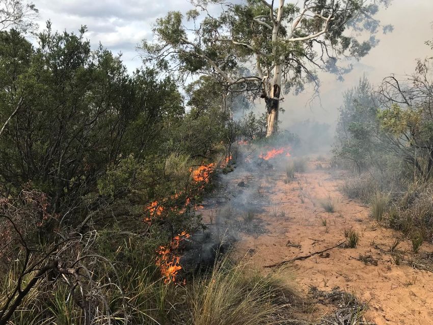
Cover page photo acknowledgement: Fuel Reduction planned burn in Autumn of 2020, Dolphin
Sands, photo courtesy of Bushfire Risk Unit, TFS.
Page 2 of 45
Bushfire Risk Management Plan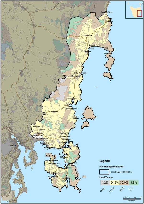
Contents
Contents ...................................................................................................................................... 3
Glossary ....................................................................................................................................... 5
Acronyms ..................................................................................................................................... 7
Executive Summary ...................................................................................................................... 8
1        Introduction ..................................................................................................................... 10
         1.1     Background........................................................................................................................ 10
         1.2     Purpose of this plan ........................................................................................................... 10
2        Establishing the context .................................................................................................... 12
         2.1     Description of the East Coast Fire Management Area ...................................................... 12
         2.2     Fire environment ............................................................................................................... 12
         2.3     Climate and bushfire season ............................................................................................. 14
         2.4     Population and community ............................................................................................... 14
         2.5     Community engagement ................................................................................................... 15
3        Identifying the risks .......................................................................................................... 16
         3.1     Bushfire and impact scenarios .......................................................................................... 16
         3.2     Statewide controls............................................................................................................. 16
         3.3     Fire Management Area controls........................................................................................ 17
4        Analysing and evaluating bushfire risk ............................................................................... 18
         4.1     Analysing bushfire risks ..................................................................................................... 18
         4.2     Evaluating bushfire risks .................................................................................................... 18
5        Bushfire risk treatment ..................................................................................................... 19
         5.1     Treatment plan .................................................................................................................. 19
         5.2     Bushfire management zones ............................................................................................. 19
         5.3     Implementing treatments ................................................................................................. 19
         5.4     Strategic fire infrastructure ............................................................................................... 20
         5.5     Fuel reduction burning ...................................................................................................... 20
6        Monitoring and review ..................................................................................................... 22
         6.1     Review ............................................................................................................................... 22
         6.2     Monitoring and reporting.................................................................................................. 22
References ................................................................................................................................. 23
Appendices ................................................................................................................................ 24
         Appendix 1: Risk register............................................................................................................. 24
         Appendix 2: Treatment plan ....................................................................................................... 33
         Appendix 3: Bushfire Management Zones .................................................................................. 38
         Appendix 4: Current implementation plans................................................................................ 39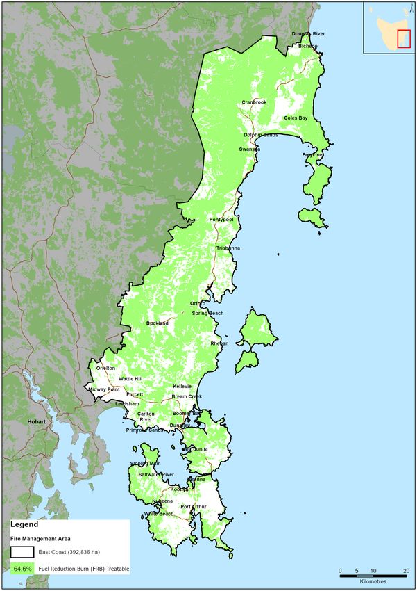
Maps ........................................................................................................................................ 40
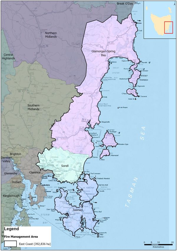
Map 1: East Coast Fire Management Area location ................................................................... 41
Map 2: Tenure summary map for East Coast Fire Management Area ....................................... 42
Map 3: Assets and values from the risk register for East Coast Fire Management Area ........... 43
Map 4: Fuel treatability for East Coast Fire Management Area ................................................. 44
Map 5: Vegetation for East Coast Fire Management Area ......................................................... 45
Page 4 of 45
Bushfire Risk Management Plan
Glossary

Glossary
Asset                   A term used to describe anything valued by the community that may be adversely impacted
                        by bushfire. This may include houses, infrastructure, agriculture, production forests, industry,
                        and environmental and heritage sites.
Asset Zone (AZ)         The geographic location of asset(s) and values of importance requiring bushfire exclusion.
Asset Protection Zone   An area adjacent to or near Asset Zones, the primary management purpose of which is to
(APZ)                   protect human life, property and highly valued assets and values. Treatment can include
                        intensive fuel reduction, manipulation of fuel moisture or response plans.
Bushfire                Unplanned vegetation fire. A generic term which includes grass fires, forest fires and scrub
                        fires both with and without a suppression objective.
Bushfire hazard         The potential or expected behaviour of a bushfire burning under a particular set of
                        conditions, i.e. the type, arrangement and quantity of fuel, the fuel moisture content, wind
                        speed, topography, relative humidity, temperature and atmospheric stability.
Bushfire Risk           A computer-based modelling tool that uses a series of inputs to assess the risk of bushfire to
Assessment Model        a specific area. The BRAM has a capacity to produce a series of outputs. It was developed and
(BRAM)                  is managed by Tasmanian Parks & Wildlife Service.
Bushfire risk           A systematic process to coordinate, direct and control activities relating to bushfire risk with
management              the aim of limiting the adverse effects of bushfire on the community.
Community Bushfire      A bushfire plan for community members that provides local, community-specific information
Protection Plan         to assist with bushfire preparation and survival. The focus of the Bushfire Protection Plan is
                        on bushfire safety options, and the intent of the plan is to support the development of
                        personal Bushfire Survival Plans.
Community Bushfire      An Emergency Management Plan for emergency managers and responders. The Bushfire
Response Plan           Response Plan aims to better protect communities and their assets during bushfire
                        emergencies, through the identification of protection priorities and operational information.
Consequence             Impact(s) of an event on the five key areas: environment, economy, people, social setting and
                        public administration.
Control                 A measure that modifies risk. This may be an existing process, policy, device, practice or other
                        action that acts to minimise negative risk or enhance positive opportunities.
Fire management         Classification system for the areas to be managed. The zoning system indicates the primary
zoning                  purposes for fire management for an area of land.
Fuel break              A natural or manmade change in fuel characteristics which affects fire behaviour so that fires
                        burning into them can be more readily controlled.
Hazard management       The area between a building and the bushfire-prone vegetation that provides access to a fire
area                    front for firefighting, which is maintained in a minimal fuel condition and in which there are
                        no other hazards present that will significantly contribute to the spread of a bushfire.
Human Settlement        Term given for the dataset used to define where people live and work. The dataset was
Area                    developed for the purpose of risk modelling and was created using a combination of building
                        locations, cadastral information and ABS data. Includes seasonally populated areas and
                        industrial areas.
Land Management         An area that is managed to meet the objectives of the relevant land manager such as:
Zone (LMZ)              Traditional Owner practices, biodiversity conservation, production forestry, farming or
                        recreation. Management can include planned burning, experimental treatments, fire
                        exclusion or no planned action.
Likelihood              Chance of something happening. It is used as a general description of probability and may be
                        expressed qualitatively or quantitatively.
Risk register           A document usually presented in a tabular form which lists concisely the following
                        information for each risk: the risk statement, source, hazard, impact area,
                        prevention/preparedness controls, recovery/response controls, level of existing controls,
                        likelihood level, risk level, confidence level and treatment strategy.
Risk treatment          Process of selection and implementation of controls to modify risk. The term ‘risk treatment’
                        is sometimes used for the controls themselves.
Glossary

Strategic Fire         An area located close to or some distance away from assets (e.g. the urban–rural interface),
Management Zone        the primary management purpose of which is to provide a mosaic of areas of reduced fuel in
(SFMZ)                 strategic locations to reduce the speed and intensity of bushfires, potential for spot-fire
                       development, and size of bushfires. Treatment is by fuel reduction burning and other bushfire
                       protection measures such as fire trails, water points, detection measures and response plans.
Treatable vegetation   Types of vegetation which are suitable for fuel reduction burning, for example, dry eucalypt
                       forest, scrub, heathland and buttongrass.
Treatment plan         A document related to the risk register presented in a tabular form which lists concisely the
                       following information for each risk: the agreed strategies to manage the risk (i.e. treatments),
                       the responsible organisations, proposed completion date and comments.

                                                                                                             Page 6 of 45
                                                                                           Bushfire Risk Management Plan
Acronyms

Acronyms
 BRMPG                Bushfire Risk Management Planning Guidelines
 BRAM                 Bushfire Risk Assessment Model
 BRMP                 Bushfire Risk Management Plan
 DPIPWE               Department of Primary Industries, Parks, Water and Environment
 FFDI                 Forest Fire Danger Index
 FMA                  Fire Management Area
 FMAC                 Fire Management Area Committee
 LGA                  Local Government Area
 PWS                  Parks and Wildlife Service
 SFMC                 State Fire Management Council
 STT                  Sustainable Timber Tasmania
 TFS                  Tasmania Fire Service

Maps contained in this document may include data provided by DPIPWE (Land Tasmania), Parks and
Wildlife Service (Fire Management Section) and Tasmania Fire Service. These map products have been
produced by the Tasmania Fire Service. While all efforts have been taken to ensure their accuracy,
there may be errors and/or omissions in the data presented. Users of these products are advised to
independently verify data for accuracy and completeness before use.
Executive Summary

Executive Summary
This Bushfire Risk Management Plan identifies priorities for the treatment of bushfire risk in the East
Coast Fire Management Area over the next three years. It was developed by the Fire Management
Area Committee (FMAC) as required under sections 18 and 20 of the Fire Service Act 1979. This plan
aims to coordinate and influence the treatment of bushfire risk in the Fire Management Area.

The East Coast Fire Management Area (FMA) covers the whole of the local government areas of
Tasman, Sorell and Glamorgan-Spring Bay. The East Coast FMA comprises an area of 393,000 hectares,
along the east coast of Tasmania, from the Tasman Peninsula in the south to Bicheno in the north. The
entire area has a total permanent population of around 22,000 people, with 70% of this population
residing in the Sorell municipality. However, tourists increase the population dramatically, e.g. 300,000
visitors are recorded annually to the Freycinet Peninsula. Most of this visitation occurs during the
summer when bushfire risk is highest.

In the Tasman and Glamorgan-Spring Bay Local Government Areas, the population is low and
dispersed, which correlates with the major land uses, being agriculture, forestry and conservation. The
landscape of the East Coast FMA includes an almost continuous band of dry eucalypt forest stretching
almost the entire length of the FMA. This could see a major fire impact a large proportion of the FMA
under serious fire weather conditions.

The majority of recorded fires have been caused by human actions, however lightning strikes are an
increasing cause of unplanned fires. There have been three very large fires (>10,000 ha) in the East
Coast FMA in the past 30 years, occurring at Waters Meeting, Kellevie and Forcett.

Tourism is a major part of the economy in the East Coast FMA and was rapidly increasing pre-COVID.
Many tourism hotspots are associated with iconic natural landscapes and have single, bushfire-prone
access routes which places large numbers of people at risk of bushfires. The increase in tourism has
also resulted in increased infrastructure in bushfire-prone areas, which combine to place additional
pressure on already stretched, predominantly volunteer-based initial fire response capabilities.

The East Coast FMAC has reviewed the results of computer modelling to identify that many of the
towns and larger communities within the FMA are the highest risk of bushfire, including Coles Bay,
Bicheno, Dolphin Sands, Triabunna, Orford, Dodges Ferry, Dunalley, Nubeena and Port Arthur.

In addition, natural values and production forests were also assessed for bushfire risk with
consideration of vulnerability to bushfire and relative impact. These values have been prioritised
according to risk rating, however, are still being evaluated for treatment, further analysis or monitor
and review.

Mitigation activities that have been recommended by the East Coast FMAC for reducing bushfire risk
includes:
•     Conducting strategic fuel reduction burns and other fuel reduction treatments around towns
      and larger communities at high risk of impact from bushfires. This work will be undertaken by
      the fire agencies, in collaboration with landowners.
•     Conducting fuel reduction burns in strategic areas to minimise the likelihood of a fire run
      impacting communities. This work will be undertaken by the fire agencies, in collaboration with
      landowners.
•     Developing Community Protection Plans and Bushfire Response Plans to support communities
      when a bushfire is threatening their area. These plans will be developed by the TFS Community
      Fire Safety Division in collaboration with local communities and stakeholders.

                                                                                                  Page 8 of 45
                                                                                Bushfire Risk Management Plan
Executive Summary
• Establishment or enhancement of Community Education initiatives, in order to enhance
community preparedness and promote positive behaviour change. This work will be undertaken
by the TFS Community Fire Safety Division in collaboration with local communities and
stakeholders.
• Other prescribed activities specific to community needs.
The plan is strategic level and does not include all details of bushfire risk treatments but does identify
which organisations or individuals are responsible for implementing them. The East Coast FMAC will
prepare a written report twice yearly for the State Fire Management Council on the progress of
implementation.
The plan was developed in line with the Bushfire Risk Management Planning Guidelines (SFMC 2020).
The risk assessment considers bushfire impacts to the assets and values in the area, and uses the
following matrix to calculate a risk rating:
The results of the risk assessment are summarised in the risk register (Appendix 1) and the proposed
treatments are listed in the treatment plan (Appendix 2). All maps are published on the internet on
LISTmap, and hyperlinks to these can be found in the relevant locations in this plan.
Page 9 of 45
Bushfire Risk Management PlanIntroduction
1 Introduction
1.1 Background
It is a requirement of Section 20 of the Fire Service Act 1979 that the Fire Management Area Committee
(FMAC) prepare a fire protection plan for its Fire Management Area. This Bushfire Risk Management
Plan (BRMP) fulfils that requirement. The BRMP is submitted to and approved by the State Fire
Management Council (SFMC).
The Fire Service Act 1979 requires that the fire protection plan is consistent with the State fire
protection plan, the Tasmanian Vegetation Fire Management Policy, and because it is an instruction
from SFMC, the Bushfire Risk Management Planning Guidelines (SFMC 2020).
The Bushfire Risk Management Planning Guidelines (BRMPG) explain the framework for bushfire risk
management in Tasmania, the method for doing the risk assessment, and how to prepare the BRMP.
There is very little explanation here in this plan on the rationale, principles and methods used;
therefore, the BRMPG is an important supporting document for understanding this plan.
Under the terms of reference for the East Coast FMAC, the purposes of the committee are:
• Provide a forum for communication and collaboration between key stakeholders in the FMA
• Enable a holistic and consistent approach, incorporating local knowledge, to identify strategic
priorities to reduce bushfire risk
• Coordinate efforts and facilitate resource sharing to implement the strategic risk reduction
priorities
• Link the local community and the SFMC through ‘ground-truthing’ the bushfire risk assessment
and mitigation strategies
• Through their advisory function, provide input into decisions and outcomes beyond the Fire
Management Area
1.2 Purpose of this plan
The management of bushfire-related risk is a collective responsibility of the whole community, with
contributions made by numerous individuals, landowners and organisations.
An overriding aim of this BRMP is to document a coordinated approach to the identification and
treatment of bushfire risk in the East Coast Fire Management Area (FMA). Specific objectives include:
• Guide and coordinate bushfire risk management over a three-year period on all land within the
FMA
• Provide a reference point for the prioritisation and justification of bushfire treatment actions,
as well as supporting evidence for funding requests
• Facilitate the integration of bushfire risk management into the business processes of councils,
organisations and land managers
• Facilitate cooperation and the coordination of treatment actions between stakeholders
• Clearly and concisely communicate bushfire risk to stakeholders and the community
• Provide a basis for monitoring and reporting of implementation of bushfire risk treatments in
the FMAIntroduction
This BRMP is a strategic-level document that does not provide detail on treatment actions. Individual
organisations and landowners, or collaborative groups, may have developed plans and processes for
implementation of bushfire risk treatment; these can be considered to be linked to the strategic
priorities identified here (SFMC 2020).
Page 11 of 45
Bushfire Risk Management PlanEstablishing the context 2 Establishing the context 2.1 Description of the East Coast Fire Management Area The plan area covers approximately 393,000ha, including the entire local government areas of Tasman, Sorell and Glamorgan-Spring Bay (Map 1). The plan area follows the coastline from the Tasman Peninsula in the South to Bicheno in the North and extends inland approximately 35km at its widest point. Altitude varies from sea level along the coast to 742m above sea level at Moaners Tier, located just to the east of Tooms Lake. The major towns within the East Coast FMA include Nubeena, Dunalley, Dodges Ferry, Sorell, Orford, Triabunna, Swansea, Coles Bay and Bicheno. Over half of the East Coast FMA consists of private property, with public land including PWS Reserves, and timber production areas making up the majority of the remaining area (Map 2). Table 1 shows the composition of different land tenures within the East Coast FMA. Table 1. Summary of the major tenure land managers in the East Coast FMA. Land manager % of FMA Private property 54.9 DPIPWE (including Parks and Wildlife and Crown Land 34.2 Services) Sustainable Timbers Tasmania 9.8 Other 1.1 2.2 Fire environment The East Coast FMA is dominated by dry eucalypt forest (57%) and agricultural areas (23%). Wet eucalypt forests (8.8%) exist on more productive soils in higher rainfall areas, which are predominantly located around the Tasman Peninsula and higher elevations of the Eastern Tiers. Highly flammable coastal complexes are common around Coles Bay, the Freycinet Peninsula and the Tasman Peninsula. The vegetation in the East Coast FMA can be categorised into 11 broad groups, shown in Map 6. The landscape of the East Coast FMA includes an almost continuous band of dry eucalypt forest stretching almost the entire length of the FMA. This could see a major fire run impacting a large proportion of the FMA under serious fire weather conditions. The causes of fire, either through ignition by lightning or caused by human actions have not been well documented prior to 1990. Records show that the causes of ignition for the majority of fires were unknown, escaped recreational fires (e.g. campfires), arson and escapes from privately managed planned burns. There have been a number of major bushfires in the East Coast FMA since 1994. Planned burning undertaken as part of the Fuel Reduction Program has occurred since 2014. Larger fires of both types are summarised in Table 2.
Establishing the context

Table 2: East Coast FMA major bushfires since 1982, and large planned burns since 2014.
 Fire Name                                             Area Burnt (ha)
 Wildfires
 Mcneills Road, Swansea 2019                           4880
 Phipps Road, Runnymede 2016                           2870
 Inala Rd 2013                                         23400
 Tasman Highway Bicheno 2013                           4830
 Douglas Apsley escaped FRB 2007/08                    8900
 Kellevie 2006                                         16000
 Oakwood Hill 2003                                     4500
 Thirty Acre Creek 1995                                4000
 Waters Meeting 1994                                   12400
 Baldy Hill 1994                                       6900
 Donkeys Track 1994                                    8327
 Major Planned Burns Undertaken:
 Station Creek, NW Orford 2018 and 2019                1160 and 435
 Simpsons Hill, Buckland 2015                          740
 Apslawn Conservation Area 2015                        445
 Tin Mine, Coles Bay 2014                              1280

The economy of the East Coast FMA is driven by agriculture/aquaculture and tourism, with the area
seeing a major and rapid increase in tourist numbers over the past ten years. Many tourism hotspots
are associated with iconic natural landscapes, e.g. Tasman Peninsula and Freycinet National Park, with
tourist numbers massively increasing the population size during the warmer months of the year. This
increase in population has resulted in an increase in development and infrastructure, which combine
to place additional pressure on already stretched, predominantly volunteer-based initial fire response
capabilities.

Many access routes to major tourist destinations are in bushfire-prone areas, with a single road in and
out. This presents additional issues for community safety during both wildfires and planned burns, with
road closures having potentially major impacts on the local economy.

Timeframes and locations available for fuel reduction burns in some parts of the East Coast FMA are
restricted due to the potential impact on tourism. An expansion in the viticulture industry throughout
the East Coast FMA also impacts the available timeframes for fuel reduction burns due to the potential
for smoke to taint grapes prior to autumn harvest.

                                                                                                Page 13 of 45
                                                                               Bushfire Risk Management Plan
Establishing the context
2.3 Climate and bushfire season
For much of the year Tasmania’s weather is dominated by westerly weather patterns. This results in
moist air being forced over rugged mountains in western and central areas of Tasmania causing heavy
rainfall in these areas as the air moves eastward. The result is relatively dry air reaching eastern parts
of Tasmania. The exception to this is the East Coast Low that forms in the Tasman Sea and brings moist
easterly winds, often causing heavy localised rainfall events. Falls in excess of 100 mm in a 24-hour
period occur on average once or twice per year. Within the East Coast FMA average annual rainfall
varies from 593 mm at Swansea to 1148 mm at Palmers lookout on the Tasman Peninsula. The East
Coast FMA can experience long, dry periods with the Soil Dryness Index (SDI) being above 100 mm for
much of the year.
Climate is changing in Tasmania and it is evident from bushfire climate indicators (Fox-Hughes et al.
2015) that we can expect destructive bushfires to become more frequent. Projections from climate
change models adapted for Tasmania suggest increases in hot days and warm nights; increases in dry
days and longer dry spells; more warm spells and heat waves; and more wet days but fewer cold spells
and cold waves. The number of total fire ban days occurring due to severe fire weather each summer
has also started to increase, with these also occurring earlier in the fire season (White, et al. 2010).
Change in climate over the past decade has also seen the occurrence of dry lightning strikes causing
fire ignitions, as a combined result of dry thunderstorms and consistently dry fuel conditions. In
addition, changes in climate have reduced the availability of water for firefighting, reduced the
predictability of timeframes for fuel reduction activities and resulted in protracted fire seasons.
2.4 Population and community
The East Coast FMA has a low total population and low population densities across the area. The entire
area has a total permanent population of around 22,000 people (Australian Bureau of Statistics – ABS,
2016), with 70% of this population residing in the Sorell municipality. The highest population densities
occur around towns and in the southwest of the area, closest to the outer settlements of Hobart, with
much of this population commuting to the greater Hobart area daily for work.
Many areas within the East Coast FMA experience a dramatic increase in visitation during the summer
tourism period. As an example, the Freycinet Peninsula has annual visitor numbers of around 300,000
individuals, with most of this visitation occurring during the summer when bushfire risk is highest.
In the Tasman and Glamorgan-Spring Bay Local Government Areas, the population is low and
dispersed, which correlates with the major land uses, particularly the large proportion of land used for
agriculture, forestry and conservation. Major sources of employment include accommodation and
food services, retail trade, agriculture/aquaculture and construction (NIEIR 2018). This is reflected in
the >50% of unoccupied dwellings in the Glamorgan-Spring Bay and Tasman Local Government Areas
(ABS, 2016), with these dwellings predominantly used for either short-term visitor accommodation or
are family-owned shacks.
The main areas of population growth are focussed around Dodges Ferry and Sorell with many new
residential housing developments occurring in these areas. In more regional areas, the population is
aging and becoming more transient, which has impacted on the recruitment and retention of volunteer
firefighters. There has also been an increase in community expectations of the responsibility of the fire
service to protect people and dwellings from bushfires, with a decreased expectation of personal
Page 14 of 45
Bushfire Risk Management PlanEstablishing the context
responsibility. This places additional pressure on local brigades to respond to incidents across an
increased population and infrastructure with fewer volunteers and no additional resources.
2.5 Community engagement
The East Coast FMAC aims to reduce the risk of the community from bushfires. This will be
implemented by:
• FMAC members providing valuable local knowledge about bushfire risks and opportunities
for fuel mitigation treatment
• Working with communities to improve their resilience strategies through the delivery of
the Bushfire Ready Neighbourhoods program and other community activities, in
partnership with local fire brigades, community organisations and Councils
• Engaging with industry organisations to improve outcomes of bushfires and planned
burns, for example:
o the wine industry around the issue of smoke taint
o tourism operators/networks to improve tourist safety during bushfires and assist in
developing plans to manage the impacts of bushfire
o TFGA to support farmers with bushfire management
• Engaging with utility companies and local councils to improve bushfire safety of critical
infrastructure
Since the inception of the TFS Fuel Reduction Program in 2014, Community Engagement has been
undertaken in the East Coast FMA. This has included the Bushfire Ready Neighbourhoods program
being run throughout the Tasman Peninsula and in Dolphin Sands from 2014-2016. Additional
community engagement activities have been undertaken as requested by local volunteer fire brigades
or the community. Several local volunteer brigades also actively undertake engagement work within
their local communities.
The East Coast FMAC noted particular concerns that bushfires in Tasmania are becoming bigger and
less predictable, while volunteer resources to manage bushfires is decreasing in the East Coast FMA.
Tasmania’s reliance on shared resources with interstate fire agencies may also be problematic when
large fires are occurring in multiple states at the same time. It was also noted that the local economy
may take many years to recover after a large bushfire, with the economy dependent on tourism
focussed on iconic wilderness features (e.g. Freycinet and Tasman Peninsulas), and with single access
roads.
The East Coast FMAC also identified the need for a holistic approach to risk management, with the
need to share identified risks with local government Emergency Management Committees.
Page 15 of 45
Bushfire Risk Management PlanIdentifying the risks
3 Identifying the risks
3.1 Bushfire and impact scenarios
To set the scene for this risk assessment, the bushfire scenarios under consideration are very large
events, typically 10,000 to 20,000 hectares, occurring when fuel dryness and weather conditions
combine to create one or more days of very significant fire weather. Analysis of climate data was used
to determine standard weather events for the scenarios – described as having an Annual Exceedance
Probability of approximately 10% (SFMC 2020).
Some important examples for the East Coast FMA may include:
• A vehicle fire on a day of FFDI 44 ignites a bushfire that spreads and impacts the town of
Orford, resulting in destruction of numerous houses, community buildings and tourist
accommodation
• A lightning strike on a day of FFDI 52, following on from a several years of below average
rainfall, ignites a bushfire that spreads quickly and cuts off the town of Coles Bay, resulting in
loss of lives and the destruction of numerous houses, tourist accommodation. Loss of
accommodation, critical infrastructure, and the aesthetic values of the landscape results in a
long-term impact to tourism industry
• A fire on a day of FFDI 60 ignites a bushfire near Eaglehawk Neck, shutting down the only
access road and causing major disruption of access and services for several days
3.2 Statewide controls
The following controls are currently in place across Tasmania to help manage bushfire-related risk:
• Legislative controls – including Fire Service Act 1979 (e.g. Fire permit period, Total Fire Ban days,
campfires), National Parks and Reserves Management Act 2002 (e.g. fires and campfires),
abatement notices
• TFS public education (e.g. Bushfire Ready Neighbourhoods, media campaigns)
• TFS planning – community protection planning (e.g. Community Response Plans)
• Fuel Reduction Program (TFS, PWS, STT) – funding and coordination of fuel reduction burning
• SFMC programs (e.g. Red Hot Tips training program for fuel reduction burning on private land)
• FMAC – performance monitoring and reporting on this BRMP
• Tasmania Police and TFS – statewide arson prevention programs
• Land subdivision and building standards (Bushfire-Prone Areas Code, Building Code of Australia)
• Private lands managed for nature conservation with a conservation covenant registered on the
land title are permitted to have planned burns undertaken with authorisation from the Minister
• Suppression response preparedness – e.g. TFS local volunteer brigades, STT and PWS crews,
forest company crews, fire towers, aircraft, pre-positioning of firefighting resources
• Weather forecasting (Bureau of Meteorology) and fire behaviour prediction (TFS, STT, PWS)
Page 16 of 45
Bushfire Risk Management PlanIdentifying the risks
3.3 Fire Management Area controls
The following controls are in place, or being developed, to assist in the management of bushfires within
the East Coast FMA:
• 19 volunteer fire brigades, plus dedicated fire crews from PWS and STT
• Fuel reduction burns have occurred around Bicheno, Orford/Spring Beach, Nugent, Eaglehawk
Neck, Nubeena
• Fuel breaks for asset protection are managed by land management agencies and landowners,
including STT, PWS, private forestry companies and others
• PWS reserves closures on bad fire days
• Community engagement programs, including Bushfire Ready Neighbourhoods, and community
development opportunities
• Preparedness planning – Community Protection Plans, Bushfire Response Plans
• PWS Emergency Management Plans
• Department of Defence Bushfire Risk Management Plan, including a “Prepare, Act, Survive” Plan
Page 17 of 45
Bushfire Risk Management PlanAnalysing and evaluating bushfire risk
4 Analysing and evaluating bushfire risk
4.1 Analysing bushfire risks
A standard risk assessment process was used to determine priorities for this Bushfire Risk Management
Plan (BRMP) following the Tasmanian Emergency Risk Assessment Guidelines and the Bushfire Risk
Management Planning Guidelines (SFMC 2020), which in summary considers:
• Consequences – what values and assets are at risk given the standard bushfire scenario under
consideration
• Existing controls – how effective the existing controls are at reducing the risk and how much
they are used
• Likelihood – how the likelihood of the consequence occurring is quantified, based on weather,
topography, fuels and ignition potential
• Confidence level – how certain we are about the evidence and data used
• Risk rating and priority score – calculated by the risk assessment tool (SFMC 2020)
All of the above are recorded in the risk register (Appendix 1).
4.2 Evaluating bushfire risks
The East Coast FMAC has reviewed the results of computer modelling to identify assets and values at
highest risk of bushfire. These areas are detailed further in Appendix 1 and shown in Map 3. Priority
assets and values include:
• Almost all towns and larger communities within the FMA are within bushfire prone areas and
are at risk of being impacted by a bushfire. This degree of risk is influenced by their population
size, proximity to bushfire-prone vegetation, single access roads, or access roads being within
bushfire-prone vegetation. These towns and communities include Coles Bay, Bicheno, Dolphin
Sands, Triabunna, Orford, Dodges Ferry, Dunalley, Nubeena and Port Arthur.
• Production forest assets with a high value that have been clustered according to bushfire impact
(identified through computer modelling).
In addition, natural values were also assessed for bushfire risk with consideration of vulnerability to
bushfire and relative impact. These values have been prioritised according to risk rating, however, are
still being evaluated for treatment, further analysis or monitor and review.
Page 18 of 45
Bushfire Risk Management PlanBushfire risk treatment
5 Bushfire risk treatment
5.1 Treatment plan
The Fire Management Area Committee (FMAC) considered the costs, benefits, practicalities and
environmental impacts of various control options for the highest priority risks. The risk treatments that
were determined from these deliberations are recorded in the treatment plan (Appendix 2).
Individual landowners and organisations are usually responsible for implementing the treatments;
these are indicated in the treatment plan. One exception is fuel reduction burning that is planned and
conducted by the Fuel Reduction Program (TFS, PWS, STT) with the agreement of landowners.
Treatments identified in this plan include:
• Fuel reduction burns around towns and larger communities and other assets in bushfire prone
areas, e.g. Tasman Peninsula, Bicheno, Orford, Forestier Peninsula
• Mechanical mitigation works where fuel reduction burns may not be practicable, e.g. Port Arthur
and Freycinet
• Community engagement activities to improve individual households understanding and
response to bushfire emergencies, e.g. Bushfire Ready Neighbourhoods program at Dodges
Ferry
• Preparation or updating of community bushfire protection and response plans to assist
emergency services to better respond to bushfires, including Penna, Dodges Ferry and Swansea
5.2 Bushfire management zones
For those assets and values where fuel management or other treatments are designated in the
treatment plan (Appendix 2), bushfire management zones are used to delineate the treatment areas.
The names of zones and descriptors are provided in Appendix 3.
Work is continuing to identify bushfire management zones within the East Coast FMA.
5.3 Implementing treatments
This Bushfire Risk Management Plan (BRMP) does not guarantee a source of funding for treatment
actions, nor does it provide a process for seeking funding. The organisations and individuals that are
responsible for delivering the bushfire risk treatments are responsible for developing further plans for
implementation, as well as arranging resources and funding.
The BRMP is, however, intended to provide evidence and justification for where funding and resources
are most appropriate to be committed by stakeholders to mitigate bushfire risk.
Many treatments identified in this plan will require environmental and cultural impact assessment.
These assessments are the responsibility of the individual organisations and are not covered by this
BRMP.Bushfire risk treatment
The following barriers have been identified with implementing several treatment types since the
inception of the Fuel Reduction Program:
• Planned burns not being undertaken due to potential issues with:
o Short weather windows for prescribed burning, due to less predictable weather, earlier
fire season, shorter weather windows and potential impacts of smoke taint on vineyards
o Landowner unwillingness to have their land burnt
o Issues with replacement costs of old rural fencing
o High-levels of visitation/tourism at critical sites (e.g. Freycinet Peninsula, Tasman National
Park) occurring during key burning windows reducing opportunities to undertake planned
burning safely
o Ongoing challenges in obtaining sufficient smoke units to progress burning in some air
catchments during stable weather conditions
o A lack of a process for prioritisation of burn units across fire agencies to assist in targeting
high priority burns when available fire resources are limited
• Effectiveness of planned burning in some areas is limited (e.g. Dolphin Sands) due to highly
flammable nature and fast return period of vegetation
• Limited resources available for initial suppression of fires, due to volunteer capacity
• Limited TFS resources available for requested community engagement
• Limited uptake and retention of community engagement programs, due to competing
priorities/low interest levels of the community, and limited support from key community groups
(e.g. local brigades)
In some priority areas, no fuel reduction treatments are identified in the treatment table. Reasons for
this are primarily due to the surrounding fuels being untreatable. Examples of this are:
• surrounding fuels are wet forest and planned burning cannot be undertaken safely during
weather windows (Port Arthur, Murdunna); or
• fuels are agricultural pastures that are not treatable (e.g. Swansea, Triabunna); or
• fuels are low as a result of recent fires (planned or unplanned) and fuel loads are currently
insufficient to carry a planned burn (e.g. Dodges Ferry, Dolphin Sands east)
In these cases, alternate treatments have been identified to address the risk, e.g. through community
education programs or the preparation of community bushfire response plans.
5.4 Strategic fire infrastructure
Strategic fire infrastructure includes access roads, fire trails, tracks and water sources. No strategic fire
infrastructure has been identified for this plan.
5.5 Fuel reduction burning
The Strategic Fire Management Zones (SFMZ) delineate general areas for treatment by fuel reduction
burning. Individual burn units are not identified in this BRMP but will need to be identified within the
SFMZ by further planning from the organisations responsible for carrying out the fuel reduction
burning.
There are many kinds of vegetation for which it is not appropriate or practical to conduct fuel reduction
burning (SFMC 2020); these vegetation communities are described as ‘untreatable’ and indicated on
Map 4. The broad vegetation communities within the FMA can be seen on Map 5.
Page 20 of 45
Bushfire Risk Management PlanBushfire risk treatment
The Fuel Reduction Program that is funded, coordinated and implemented by the Tasmania Fire
Service, Parks and Wildlife Service and Sustainable Timbers Tasmania is undertaken on behalf of and
with the agreement of individual landowners or organisations (e.g. councils). The priorities of the Fuel
Reduction Program are guided by the priorities identified in the treatment plans across all Fire
Management Areas.
Page 21 of 45
Bushfire Risk Management PlanMonitoring and review
6 Monitoring and review
6.1 Review
This Bushfire Risk Management Plan (BRMP), including appendices and maps, will be subject to a
comprehensive review every three (3) years from the date of approval, unless significant
circumstances exist to warrant earlier review. The revised BRMP will be based on a new risk
assessment that may include revised input methods. The review process will include examination of:
• changes to the Fire Management Area (FMA), organisational responsibilities or legislation
• changes to the bushfire risk in the area
• major bushfire events
• shortcomings in data that can be improved
• change of usage of the area
• new or changed asset values within the FMA
Additional and changed data and values (both community and natural) identified by the review process
will be supplied to the Bushfire Risk Unit (TFS) for inclusion in ongoing risk modelling being carried out
at the state level.
6.2 Monitoring and reporting
Progress towards completion of the treatments proposed will be monitored and reviewed twice a year
by the Fire Management Area Committee (FMAC); this will be documented in the Implementation
Status Report which should address as a minimum:
• progress on implementation of treatments listed in the treatment plan, including
• planning outcomes including mitigation plans, community protection plans, community
response plans
• implementation progress of community programs
• completed fuel reduction burns
• development and maintenance of Asset Protection Zones (APZ)
• development and maintenance of strategic fire infrastructure
At a Statewide level, the State Fire Management Council will examine the impacts of the strategic
burning program on risk management as part of the strategic fuel management program.
Page 22 of 45
Bushfire Risk Management PlanReferences
References
Fox-Hughes, P., Harris, R.M.B., Lee, G., Jabour, J., Grose, M.R., Remenyi, T.A. and Bindoff, N.L. (2015).
Climate Futures for Tasmania future fire danger: the summary and the technical report, Antarctic
Climate & Ecosystems Cooperative Research Centre, Hobart, Tasmania. Retrieved from
http://acecrc.org.au/wp-content/uploads/2015/12/Report_CFT_Future-Fire-Technical-
Report_2015_web.pdf.
TERAG (2017), Tasmanian Emergency Risk Assessment Guidelines. Department of Police, Fire and
Emergency Management, Tasmania. Retrieved from http://www.ses.tas.gov.au/about/risk-
management/terag/
SFMC (2020), Bushfire Risk Management Planning Guidelines, State Fire Management Council,
Tasmania. Retrieved from
http://www.sfmc.tas.gov.au/sites/sfmc.tas.gov.au/files/Bushfire%20Risk%20Management%20Planni
ng%20Guidelines%202020.pdf
Page 23 of 45
Bushfire Risk Management PlanAppendices
Appendices
Appendix 1: Risk register
Notes at the end of the risk register provide explanation for the TERAG code, Asset description and Priority FMAC columns.
TERAG Asset Asset description (risk Consequence Controls Confidence Combined Risk level Priority Treatment LGA
code category statement) effectiveness likelihood FMAC options
ECSO010 Historic Coal Mines Historic Site Major Medium Highest Unlikely High 11 Further analysis Tasman
Heritage
ECSO005 Human Diamond Hill, Douglas River, Major Low Highest Unlikely High 11 Treatment Glamorgan-
Settlement Bicheno Spring Bay
Area
ECSO007 Human Spring Beach Major Low Highest Unlikely High 11 Further analysis Glamorgan-
Settlement Spring Bay
Area
ECSO002 Human Yellow Sandbanks, Dolphin Major Medium Highest Unlikely High 11 Treatment Glamorgan-
Settlement Sands Spring Bay
Area
ECPE044 Human Mount Stacey, Coles Bay, Muirs Major Medium Highest Unlikely High 12 Further analysis Glamorgan-
Settlement Place Spring Bay
Area
ECSO001 Human Mount Stacey, Coles Bay, Muirs Major Medium Highest Unlikely High 12 Treatment Glamorgan-
Settlement Place Spring Bay
Area
ECSO006 Human Allanbys Hill, Copping Major Low Highest Unlikely High 13 Further analysis Sorell
Settlement
Area
ECSO003 Human Double Creek, Orford, Major Low Highest Unlikely High 13 Treatment Glamorgan-
Settlement Triabunna Spring Bay
Area
ECSO004 Human Swansea, Kennedia Place, Major Very Low Highest Unlikely High 13 Treatment Glamorgan-
Settlement Webber Point Spring Bay
Area
ECPE002 Human Carlton, Carlton River, Dodges Major Low Highest Unlikely High 14 Treatment Sorell
Settlement Ferry
Area
Page 24 of 45
Bushfire Risk Management PlanAppendices
TERAG Asset Asset description (risk Consequence Controls Confidence Combined Risk level Priority Treatment LGA
code category statement) effectiveness likelihood FMAC options
ECSO009 Human Bream Creek Major Very Low Highest Rare High 19 Further analysis Sorell
Settlement
Area
ECSO008 Human Tunbridge Hill Major Very Low Highest Rare High 19 Further analysis Sorell
Settlement
Area
ECPE026 Human Billy Blue Hill, Nubeena Moderate Low Highest Unlikely Medium 24 Treatment Tasman
Settlement
Area
ECPE025 Human Diamond Hill, Douglas River, Moderate Low Highest Unlikely Medium 24 Treatment Glamorgan-
Settlement Bicheno Spring Bay
Area
ECPE012 Human Eaglehawk Neck, Murdunna, Moderate Low Highest Unlikely Medium 24 Treatment Tasman
Settlement Pauls Hill
Area
ECPE003 Human Port Arthur, Oakwood Hill, Moderate Low Highest Unlikely Medium 24 Treatment Tasman
Settlement Carnarvon Bay
Area
ECPE036 Human Spring Beach Moderate Low Highest Unlikely Medium 24 Treatment Glamorgan-
Settlement Spring Bay
Area
ECPE010 Human Yellow Sandbanks, Dolphin Moderate Medium Highest Unlikely Medium 24 Treatment Glamorgan-
Settlement Sands Spring Bay
Area
ECPE006 Human Mount Stacey, Coles Bay, Muirs Moderate Medium Highest Unlikely Medium 25 Treatment Glamorgan-
Settlement Place Spring Bay
Area
ECPE008 Human Corn Hill, Little Hill, Pawleena, Moderate Very Low Highest Unlikely Medium 26 Treatment Sorell
Settlement Sorell
Area
ECPE011 Human Double Creek, Orford, Moderate Low Highest Unlikely Medium 26 Treatment Glamorgan-
Settlement Triabunna Spring Bay
Area
ECPE023 Human Midway Point, Penna Moderate Medium Highest Unlikely Medium 26 Treatment Sorell
Settlement
Area
Page 25 of 45
Bushfire Risk Management PlanAppendices
TERAG Asset Asset description (risk Consequence Controls Confidence Combined Risk level Priority Treatment LGA
code category statement) effectiveness likelihood FMAC options
ECPE019 Human Swansea, Kennedia Place, Moderate Very Low Highest Unlikely Medium 26 Treatment Glamorgan-
Settlement Webber Point Spring Bay
Area
ECPE001 Human Forcett, Bullock Hill Moderate Low Highest Unlikely Medium 27 Monitor and Sorell
Settlement review
Area
ECPE020 Human Lewisham Moderate Very Low Highest Unlikely Medium 27 Treatment Sorell
Settlement
Area
ECPE037 Human Dunalley, Boomer Bay Moderate Medium Highest Unlikely Medium 29 Treatment Sorell
Settlement
Area
ECPE028 Human Primrose Sands Moderate Low Highest Unlikely Medium 29 Monitor and Sorell
Settlement review
Area
ECPE038 Human Taranna Moderate Low Highest Unlikely Medium 29 Monitor and Tasman
Settlement review
Area
ECPE042 Human White Beach Moderate Low Highest Unlikely Medium 29 Treatment Tasman
Settlement
Area
ECPE034 Human Allanbys Hill, Copping Minor Low Highest Unlikely Low Sorell
Settlement
Area
ECPE005 Human Ardross Hill, Buckland Minor Very Low Highest Unlikely Low Glamorgan-
Settlement Spring Bay
Area
ECPE043 Human Bream Creek Minor Very Low Highest Rare Low Sorell
Settlement
Area
ECPE004 Human Cashs Lookout Minor Very Low Highest Unlikely Low Tasman
Settlement
Area
ECPE007 Human Connellys Bay Minor Low Highest Rare Low Sorell
Settlement
Area
Page 26 of 45
Bushfire Risk Management PlanAppendices
TERAG Asset Asset description (risk Consequence Controls Confidence Combined Risk level Priority Treatment LGA
code category statement) effectiveness likelihood FMAC options
ECPE035 Human Corner Hill, Boltons Shoal Minor Very Low Highest Unlikely Low Glamorgan-
Settlement Spring Bay
Area
ECPE009 Human Cranbrook, Freestone Hill Minor Very Low Highest Unlikely Low Glamorgan-
Settlement Spring Bay
Area
ECPE013 Human Flat Top Hill, Orielton Minor Low Highest Unlikely Low Sorell
Settlement
Area
ECPE014 Human Freycinet Minor Medium Highest Very Rare Very Low Glamorgan-
Settlement Spring Bay
Area
ECPE016 Human Gwandalan Minor Very Low Highest Rare Low Tasman
Settlement
Area
ECPE017 Human Heathy Hill Minor Very Low Highest Rare Low Tasman
Settlement
Area
ECPE015 Human Koonya, Grooms Hill Minor Low Highest Unlikely Low Tasman
Settlement
Area
ECPE021 Human Little Chinaman Bay Minor Very Low Highest Rare Low Tasman
Settlement
Area
ECPE018 Human Marion Bay, Kellevie Minor Very Low Highest Unlikely Low Sorell
Settlement
Area
ECPE024 Human Mount Peter Minor Very Low Highest Unlikely Low Glamorgan-
Settlement Spring Bay
Area
ECPE022 Human Pontypool, Little Swanport Minor Low Highest Unlikely Low Glamorgan-
Settlement Spring Bay
Area
ECPE027 Human Premaydena Minor Low Highest Rare Low Tasman
Settlement
Area
Page 27 of 45
Bushfire Risk Management PlanAppendices
TERAG Asset Asset description (risk Consequence Controls Confidence Combined Risk level Priority Treatment LGA
code category statement) effectiveness likelihood FMAC options
ECPE029 Human Rheban Minor Very Low Highest Rare Low Glamorgan-
Settlement Spring Bay
Area
ECPE030 Human River and Rocks Road Minor Very Low Highest Rare Low Glamorgan-
Settlement Spring Bay
Area
ECPE033 Human Sappho Spit, Windlass Bay Insignificant Very Low Highest Unlikely Low Glamorgan-
Settlement Spring Bay
Area
ECPE032 Human Sloping Main, Saltwater River Minor Very Low Highest Unlikely Low Tasman
Settlement
Area
ECPE039 Human Taylors Hill Insignificant Low Highest Unlikely Low Sorell
Settlement
Area
ECPE040 Human Tunbridge Hill Minor Very Low Highest Rare Low Sorell
Settlement
Area
ECPE041 Human Wattle Hill Insignificant Low Highest Rare Very Low Sorell
Settlement
Area
ECPE031 Human Yellow Sandbanks Road, Nine Minor Low Highest Rare Low Glamorgan-
Settlement Mile Beach Spring Bay
Area
ECEN003 Natural Value Antipodia, Notelaea, Major Very Low Highest Likely Extreme 2 Glamorgan-
Oreixenica, Regenerating, Spring Bay
Remnant rainforest
ECEN002 Natural Value Cloud, Remnant rainforest Major Medium Highest Unlikely High 10 Tasman
ECEN006 Natural Value Lissotes, Remnant rainforest, Major Medium Highest Unlikely High 10 Sorell
Sphagnum
ECEN008 Natural Value Remnant rainforest Major Medium Highest Unlikely High 10 Tasman
ECEN011 Natural Value Remnant rainforest Major Medium Highest Unlikely High 10 Tasman
ECEN005 Natural Value Antipodia, Melaleuca, Major Low Highest Unlikely High 11 Glamorgan-
Regenerating, Remnant Spring Bay
rainforest
ECEN007 Natural Value Oreixenica, Regenerating, Major Very Low Highest Unlikely High 12 Treatment Glamorgan-
Remnant rainforest Spring Bay
Page 28 of 45
Bushfire Risk Management PlanAppendices
TERAG Asset Asset description (risk Consequence Controls Confidence Combined Risk level Priority Treatment LGA
code category statement) effectiveness likelihood FMAC options
ECEN001 Natural Value Cloud, Lissotes, Tasmanian Major Very Low Highest Unlikely High 13 Glamorgan-
Spring Bay
ECEN009 Natural Value Remnant rainforest Major Very Low Highest Unlikely High 13 Tasman
ECEN010 Natural Value Remnant rainforest Major Very Low Highest Unlikely High 15 Tasman
ECEN004 Natural Value Antipodia, Tasmanian Moderate Very Low Highest Unlikely Medium 25 Glamorgan-
Spring Bay
ECPE045 Other Marion Bay Falls Festival site Catastrophic Medium Highest Unlikely Extreme 4 Further analysis Sorell
ECEC004 Production PB_esr_4t, PB_esr_5t, Major Low Highest Likely Extreme 2 Glamorgan-
Forest PC_rad_5t, SW_esr, SW_esr_s, Spring Bay
TO023D
ECEC005 Production HI01, HI01C, HI01L, HI02, Major Medium Highest Unlikely High 10 Tasman
Forest HI02A, HI02B, HI02D, HI02E,
HI02M, KY001B, KY001C,
KY001E, KY001G, KY001H,
KY002A, KY005E, KY005Z,
KY008B, PB_esr_2, PB_esr_3,
PB_esr_4t, PB_esr_5t,
PC_esr_5t, PC_esr_6s,
PC_rad_1s, PC_rad_2,
PC_rad_5t, S...truncated text...
ECEC009 Production FT001A, FT002E, FT008E, Major Very Low Highest Unlikely High 11 Tasman
Forest FT008I, FT008K, FT008N,
FT008V, FT012B, FT013D,
FT013I, FT015K, PB_esr_3,
PB_esr_4t, PB_esr_5t,
PC_esr_6s, PC_rad_4, SW_esr
ECEC001 Production MM025C, PB_esr_3, PB_esr_4t, Major Very Low Highest Unlikely High 11 Sorell
Forest PB_esr_5t, PC_rad_4,
PC_rad_5t, PC_rad_6s, SW_esr
ECEC006 Production MM06, PB_esr_3, PB_esr_4t, Major Very Low Highest Unlikely High 11 Sorell
Forest PB_esr_5t, PC_rad_4,
PC_rad_5t
ECEC002 Production PB_esr_2, PB_esr_3, PB_esr_4t, Major Very Low Highest Unlikely High 12 Treatment Glamorgan-
Forest PC_esr_3, PC_esr_6s, SW_esr, Spring Bay
SW_esr_s, SW074D, SW102C,
SW105E, SW110B, SW116B,
SW116E, SW117A, SW117B,
Page 29 of 45
Bushfire Risk Management PlanAppendices
TERAG Asset Asset description (risk Consequence Controls Confidence Combined Risk level Priority Treatment LGA
code category statement) effectiveness likelihood FMAC options
SW124A, SW125G, SW126H,
SW126I, SW126X, SW128G
ECEC008 Production PB_esr_3, PB_esr_4t, Major Very Low Highest Unlikely High 12 Treatment Tasman
Forest PB_esr_5t
ECEC003 Production PB_esr_3, PB_esr_4t, Major Very Low Highest Unlikely High 12 Treatment Glamorgan-
Forest PB_esr_5t, PC_rad_5t, Spring Bay
PC_rad_6s, SW_esr, SW_esr_s,
WT010B, WT044A
ECEC010 Production SW_esr Minor Very Low Highest Likely Medium 23 Glamorgan-
Forest Spring Bay
ECEC013 Production PB_esr_4t, SW_esr Moderate Very Low Highest Unlikely Medium 24 Glamorgan-
Forest Spring Bay
ECEC015 Production PB_esr_3 Moderate Very Low Highest Unlikely Medium 25 Sorell
Forest
ECEC007 Production PB_esr_3, PC_rad_4 Minor Very Low Highest Unlikely Low Sorell
Forest
ECEC014 Production PC_rad_4 Minor Very Low Highest Unlikely Low Sorell
Forest
ECEC011 Production PC_rad_5t Minor Very Low Highest Unlikely Low Tasman
Forest
ECEC012 Production PC_rad_5t Minor Very Low Highest Rare Low Sorell
Forest
Page 30 of 45
Bushfire Risk Management PlanYou can also read