North East Fire Management Area
Bushfire Risk Management Plan
2021
←
→
Page content transcription
If your browser does not render page correctly, please read the page content below
North East Fire Management Area Bushfire Risk Management Plan 2021

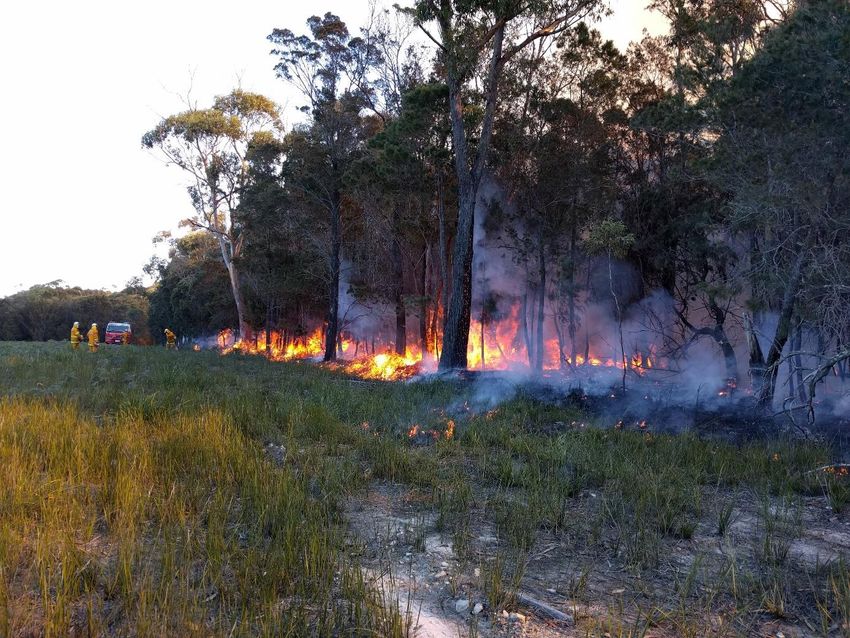
Document Control
Document History
 Version                 Date                   Author                  Section

 1.0                     02/2021                L Murray

Document Endorsements
 Agency                  Name & Title           Signature               Date

Document Endorsement by North East Fire Management Area Committee

Chris Hughes, Chair, North East FMAC

Date: 11/03/2021

Accepted by State Fire Management Council

Ian Sauer, Chair, SFMC

Date: 30/03/2021

Cover Page Photo Acknowledgement: Diana’s Basin Fuel Reduction Burn, photo courtesy Leon Murray
Contents
Glossary ....................................................................................................................................... 5
Acronyms ..................................................................................................................................... 7
Executive Summary ...................................................................................................................... 8
1.       Introduction ..................................................................................................................... 10
         1.1 Background ........................................................................................................................... 10
         1.2 Purpose of this plan .............................................................................................................. 10
2.       Establishing the context .................................................................................................... 12
         2.1 Description of the North East Fire Management Area ......................................................... 12
         2.2 Fire environment................................................................................................................... 12
         2.3 Climate and bushfire season ................................................................................................. 13
         2.4 Population and community ................................................................................................... 16
         2.5 Community engagement....................................................................................................... 17
3.       Identifying the risks .......................................................................................................... 18
         3.1 Bushfire and impact scenarios .............................................................................................. 18
         3.2 Statewide controls ................................................................................................................ 18
         3.3 Fire Management Area controls ........................................................................................... 19
4.       Analysing and evaluating bushfire risk ............................................................................... 20
         4.1 Analysing bushfire risks ......................................................................................................... 20
         4.2 Evaluating bushfire risks ....................................................................................................... 20
5.       Bushfire risk treatment ..................................................................................................... 21
         5.1 Treatment plan...................................................................................................................... 21
         5.2 Bushfire management zones................................................................................................. 21
         5.3 Implementing treatments ..................................................................................................... 21
         5.4 Strategic fire infrastructure ................................................................................................... 22
         5.5 Fuel reduction burning .......................................................................................................... 22
6.       Monitoring and review ..................................................................................................... 23
         6.1 Review ................................................................................................................................... 23
         6.2 Monitoring and reporting ..................................................................................................... 23
References ................................................................................................................................. 24
Appendices ................................................................................................................................ 25
         Appendix 1: Risk register............................................................................................................. 25
         Appendix 2: Treatment plan ....................................................................................................... 40
         Appendix 3: Bushfire Management Zones .................................................................................. 52
         Appendix 4: Strategic Fire Trails.................................................................................................. 53
         Appendix 5: Current implementation plans................................................................................ 54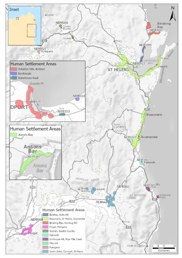
Maps ......................................................................................................................................... 55
         Map 1: North East Fire Management Area location ................................................................... 56
         Map 2: Tenure summary map for North East Fire Management Area ....................................... 57
         Map 3: Assets and values from the risk register for North East Fire Management Area ........... 58
         Map 4: Fuel treatability for North East Fire Management Area ................................................. 59
         Map 5: Vegetation for North East Fire Management Area ......................................................... 60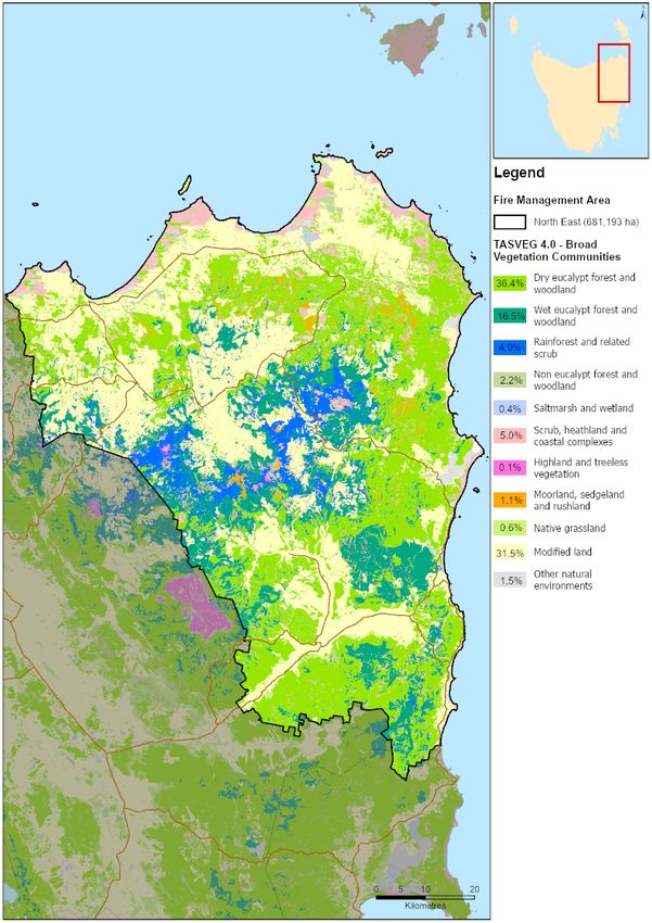
Glossary

Glossary
Asset                   A term used to describe anything valued by the community that may be adversely impacted
                        by bushfire. This may include houses, infrastructure, agriculture, production forests, industry,
                        and environmental and heritage sites.
Asset Zone (AZ)         The geographic location of asset(s) and values of importance requiring bushfire exclusion.
Asset Protection Zone   An area adjacent to or near Asset Zones, the primary management purpose of which is to
(APZ)                   protect human life, property and highly valued assets and values. Treatment can include
                        intensive fuel reduction, manipulation of fuel moisture or response plans.
Bushfire                Unplanned vegetation fire. A generic term which includes grass fires, forest fires and scrub
                        fires both with and without a suppression objective.
Bushfire hazard         The potential or expected behaviour of a bushfire burning under a particular set of
                        conditions, i.e. the type, arrangement and quantity of fuel, the fuel moisture content, wind
                        speed, topography, relative humidity, temperature and atmospheric stability.
Bushfire Risk           A computer-based modelling tool that uses a series of inputs to assess the risk of bushfire to
Assessment Model        a specific area. The BRAM has a capacity to produce a series of outputs. It was developed and
(BRAM)                  is managed by Tasmanian Parks & Wildlife Service.
Bushfire risk           A systematic process to coordinate, direct and control activities relating to bushfire risk with
management              the aim of limiting the adverse effects of bushfire on the community.
Community Bushfire      A bushfire plan for community members that provides local, community-specific information
Protection Plan         to assist with bushfire preparation and survival. The focus of the Bushfire Protection Plan is
                        on bushfire safety options, and the intent of the plan is to support the development of
                        personal Bushfire Survival Plans.
Community Bushfire      An Emergency Management Plan for emergency managers and responders. The Bushfire
Response Plan           Response Plan aims to better protect communities and their assets during bushfire
                        emergencies, through the identification of protection priorities and operational information.
Consequence             Impact(s) of an event on the five key areas: environment, economy, people, social setting and
                        public administration.
Control                 A measure that modifies risk. This may be an existing process, policy, device, practice or other
                        action that acts to minimise negative risk or enhance positive opportunities.
Fire management         Classification system for the areas to be managed. The zoning system indicates the primary
zoning                  purposes for fire management for an area of land.
Fuel break              A natural or manmade change in fuel characteristics which affects fire behaviour so that fires
                        burning into them can be more readily controlled.
Hazard management       The area between a building and the bushfire-prone vegetation that provides access to a fire
area                    front for firefighting, which is maintained in a minimal fuel condition and in which there are
                        no other hazards present that will significantly contribute to the spread of a bushfire.
Human Settlement        Term given for the dataset used to define where people live and work. The dataset was
Area                    developed for the purpose of risk modelling and was created using a combination of building
                        locations, cadastral information and ABS data. Includes seasonally populated areas and
                        industrial areas.
Land Management         An area that is managed to meet the objectives of the relevant land manager such as:
Zone (LMZ)              Traditional Owner practices, biodiversity conservation, production forestry, farming or
                        recreation. Management can include planned burning, experimental treatments, fire
                        exclusion or no planned action.
Likelihood              Chance of something happening. It is used as a general description of probability and may be
                        expressed qualitatively or quantitatively.
Risk register           A document usually presented in a tabular form which lists concisely the following
                        information for each risk: the risk statement, source, hazard, impact area,
                        prevention/preparedness controls, recovery/response controls, level of existing controls,
                        likelihood level, risk level, confidence level and treatment strategy.
Risk treatment          Process of selection and implementation of controls to modify risk. The term ‘risk treatment’
                        is sometimes used for the controls themselves.

                                                                                                               Page 5 of 60
                                                                                             Bushfire Risk Management Plan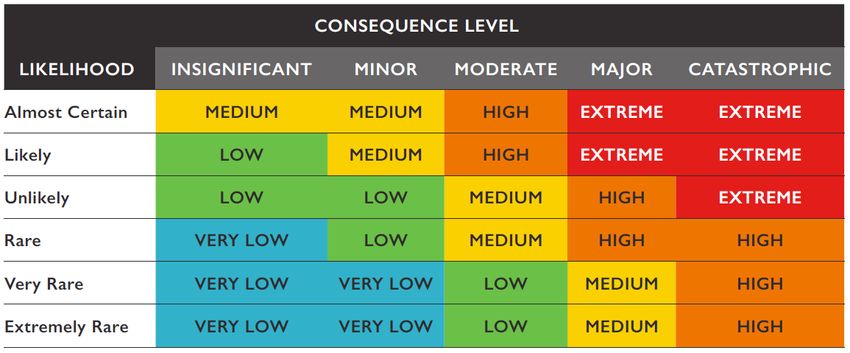
Glossary

Strategic Fire         An area located close to or some distance away from assets (e.g. the urban–rural interface),
Management Zone        the primary management purpose of which is to provide a mosaic of areas of reduced fuel in
(SFMZ)                 strategic locations to reduce the speed and intensity of bushfires, potential for spot-fire
                       development, and size of bushfires. Treatment is by fuel reduction burning and other bushfire
                       protection measures such as fire trails, water points, detection measures and response plans.
Treatable vegetation   Types of vegetation which are suitable for fuel reduction burning, for example, dry eucalypt
                       forest, scrub, heathland and buttongrass.
Treatment plan         A document related to the risk register presented in a tabular form which lists concisely the
                       following information for each risk: the agreed strategies to manage the risk (i.e. treatments),
                       the responsible organisations, proposed completion date and comments.

                                                                                                             Page 6 of 60
                                                                                           Bushfire Risk Management Plan
Acronyms
Acronyms
BRMPG Bushfire Risk Management Planning Guidelines
BRAM Bushfire Risk Assessment Model
BRMP Bushfire Risk Management Plan
DPIPWE Department of Primary Industries, Parks, Water and Environment
FFDI Forest Fire Danger Index
FMA Fire Management Area
FMAC Fire Management Area Committee
LGA Local Government Area
PWS Parks and Wildlife Service
SFMC State Fire Management Council
STT Sustainable Timber Tasmania
TFS Tasmania Fire Service
Maps contained in this document may include data provided by DPIPWE (Land Tasmania), Parks and
Wildlife Service (Fire Management Section) and Tasmania Fire Service. These map products have been
produced by the Tasmania Fire Service. While all efforts have been taken to ensure their accuracy,
there may be errors and/or omissions in the data presented. Users of these products are advised to
independently verify data for accuracy and completeness before use.
Page 7 of 60
Bushfire Risk Management PlanExecutive Summary
Executive Summary
This Bushfire Risk Management Plan identifies priorities for the treatment of bushfire risk in the North
East Fire Management Area over the next three years. It was developed by the Fire Management Area
Committee (FMAC) as required under sections 18 and 20 of the Fire Service Act 1979. This plan aims
to coordinate and influence the treatment of bushfire risk in the Fire Management Area.
The plan is strategic level and does not include all details of bushfire risk treatments but does identify
which organisations or individuals are responsible for implementing them. The North East FMAC will
prepare a written report twice yearly for the State Fire Management Council on the progress of
implementation.
The plan was developed in line with the Bushfire Risk Management Planning Guidelines 2020. The risk
assessment considers bushfire impacts to the assets and values in the area, and uses the following
matrix to calculate a risk rating:
The North East FMA comprises 681,193ha and has a population of approximately 12,844.
Approximately two thirds of the human settlement areas are found inland (Scottsdale and Fingal
Valley) with the remainder along the coastal strip (Bridport, Musselroe Bay, Ansons Bay, Binalong Bay
and St Helens to Scamander). The population of the coastal human settlement areas swell during the
summer months as do towns associated with mountain bike trails, golf courses, beaches, national
parks, and other attractions.
The principal industries within the North East FMA are agriculture and forestry with other key
employment generators being retail, accommodation, food services and manufacturing.
The results of the risk assessment are summarised in the risk register (Appendix 1) and the proposed
treatments are listed in the treatment plan (Appendix 2). All maps are published on the internet on
LIST map, and hyperlinks to these can be found in the relevant locations in this plan.
The highest priority risks identified by the North East FMAC are broadly defined as:
• Human Settlement Areas: St Helens to Scamander, Bridport/Ockerbys Hill, St Marys, Ansons Bay,
Binalong Bay/Humbug Hill, Musselroe Bay, Fingal/Mangana, Mathinna, Gladstone,
Baretop/Nicks Hill. Strategic planning to identify risk mitigation activities (fuel reduction
burning, fuel breaks, emergency management planning, community education or further
analysis of the risk) are the individual or collective responsibility of the TFS, PWS, STT, local
government, infrastructure providers and private forestry companies.
Page 8 of 60
Bushfire Risk Management PlanExecutive Summary
• Natural Values: Fire sensitive species and communities. Investigating treatment options is the
responsibility of PWS.
• Production Forests: Forestry clusters interspersed within the FMA, multiple owners
• Mountain Bike Trails: Blue Derby and St Helens mountain bike trails. Risk mitigation activities
(fuel reduction burning, emergency management planning) is the individual or collective
responsibility of TFS, PWS, STT and local government.
• Campgrounds: Bay of Fires campgrounds. Risk mitigation activities is the responsibility of PWS.
• Collieries: Blackwood, Cullenswood and Duncan collieries. Further analysis of existing risk
mitigation measures must be investigated to determine the most appropriate ways to reduce
bushfire risk. This remains the responsibility of the colliery owners and the FMAC.
When further assets are identified, the FMAC will determine whether these assets require assessment
against the TERAG risk assessment process.
Page 9 of 60
Bushfire Risk Management PlanIntroduction
1. Introduction
1.1 Background
It is a requirement of Section 20 of the Fire Service Act 1979 that the Fire Management Area Committee
(FMAC) prepare a fire protection plan for its Fire Management Area. This Bushfire Risk Management
Plan (BRMP) fulfils that requirement. The BRMP is submitted to and approved by the State Fire
Management Council (SFMC).
The Fire Service Act 1979 requires that the fire protection plan is consistent with the State fire
protection plan, the Tasmanian Vegetation Fire Management Policy, and because it is an instruction
from SFMC, the Bushfire Risk Management Planning Guidelines (SFMC 2020).
The Bushfire Risk Management Planning Guidelines (BRMPG) explain the framework for bushfire risk
management in Tasmania, the method for doing the risk assessment, and how to prepare the BRMP.
There is very little explanation here in this plan on the rationale, principles and methods used;
therefore, the BRMPG is an important supporting document for understanding this plan.
Under the terms of reference for the North East FMAC, the purposes of the committee are:
• Provide a forum for communication and collaboration between key stakeholders in the FMA
• Enable a holistic and consistent approach, incorporating local knowledge, to identify strategic
priorities to reduce bushfire risk
• Coordinate efforts and facilitate resource sharing to implement the strategic risk reduction
priorities
• Link the local community and the SFMC through ‘ground-truthing’ the bushfire risk assessment
and mitigation strategies
• Through their advisory function, provide input into decisions and outcomes beyond the Fire
Management Area
1.2 Purpose of this plan
The management of bushfire-related risk is a collective responsibility of the whole community, with
contributions made by numerous individuals, landowners and organisations.
An overriding aim of this BRMP is to document a coordinated approach to the identification and
treatment of bushfire risk in the North East Fire Management Area (FMA). Specific objectives include:
• Guide and coordinate bushfire risk management over a three-year period on all land within the
FMA
• Provide a reference point for the prioritisation and justification of bushfire treatment actions,
as well as supporting evidence for funding requests
• Facilitate the integration of bushfire risk management into the business processes of councils,
organisations and land managers
• Facilitate cooperation and the coordination of treatment actions between stakeholders
• Clearly and concisely communicate bushfire risk to stakeholders and the community
• Provide a basis for monitoring and reporting of implementation of bushfire risk treatments in
the FMA.
Page 10 of 60
Bushfire Risk Management PlanIntroduction
This BRMP is a strategic-level document that does not provide detail on treatment actions. Individual
organisations and landowners, or collaborative groups, may have developed plans and processes for
implementation of bushfire risk treatment; these can be considered to be linked to the strategic
priorities identified here (SFMC 2020).
Page 11 of 60
Bushfire Risk Management PlanEstablishing the context
2. Establishing the context
2.1 Description of the North East Fire Management Area
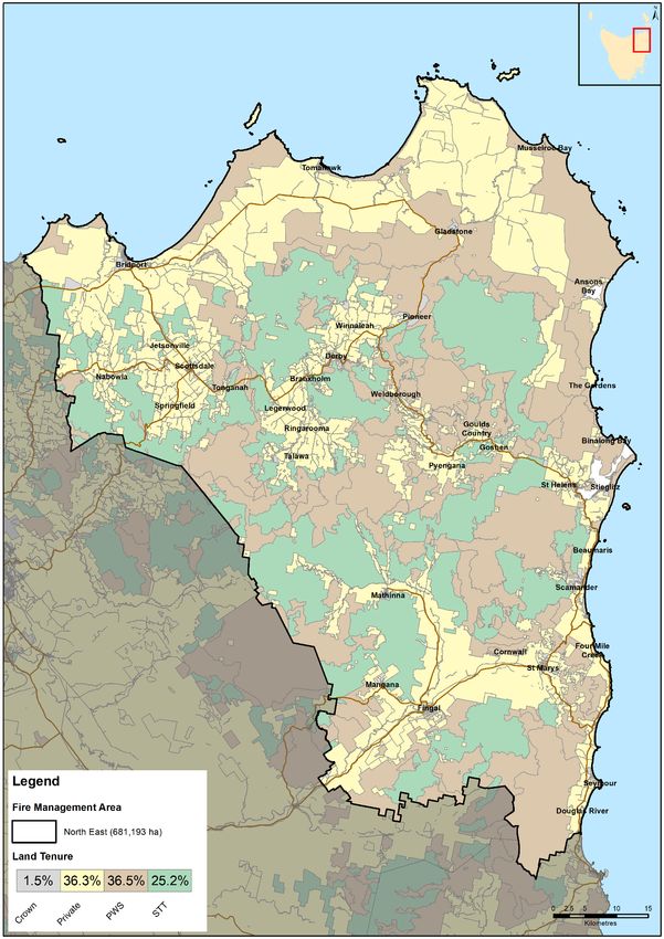
The North East Fire Management Area covers a total area of 681,193 ha and encompasses the local
government areas of Dorset and Break O’Day (Map 1). The FMA covers an area bounded by the north
and east coastlines (and associated islands close to the mainland of Tasmania). It extends in a south
easterly direction from the mouth of Little Pipers River to just below the mouth of the Douglas River
on the east coast.
Within the FMA there is a mixture of public land managed by DPIPWE, private freehold land and
Sustainable Timbers Tasmania managed land (Map 2). Table 1 shows the composition of different land
tenures present within the North East FMA.
Table 1. Summary of the major tenure land managers in the North East Fire Management Area
(FMA).
Land manager % of FMA
Private property 34
Parks and Wildlife Service 38
reserves/Crown
Sustainable Timbers Tasmania 25
Other 3
2.2 Fire environment
Interspersed with agriculture and forestry (plantation) developments, vegetation within the North East
FMA consists of open sclerophyll woodlands in lowlands, heath complexes on coastal plains, wet and
dry sclerophyll forest inland and some rain forest and alpine and sub alpine complexes on the upper
slopes of the elevated terrain. High productivity button grass is also present.
Categorised into broad groups (Kitchener & Harris, 2013), vegetation in the North East FMA is
summarised in Map 5.
Vegetation can also be classified as treatable or untreatable which is important for fuel reduction
burning treatment purposes (Map 4). Of the total land area 45% is considered as treatable fuels
suitable for planned burning. Treatable fuels are typically dry eucalypt forest, scrub complexes, heath
complexes and button grass. Agricultural lands while susceptible to the impact of bush fires are not
The climate of the North East FMA can be classified as a cool temperate climate, with warm summer
temperatures and cool winters. The area is associated with moist and dry sub humid conditions on the
coastal plains systems together with humid cool/ cold elevated areas.
Rainfall occurs mainly on elevated mountain ranges; a lower rainfall amount is received on the narrow
coastal strip. The driest part of the FMA is in the lower Fingal Ranges. There is variability in rainfall
between years particularly in coastal areas. The coast is also exposed to strong winds.
consider treatable due to the nature of the land use. However, this does not preclude agricultural land
from being incorporated into burning operations.
Available records show that there are various causes of ignitions for bushfires in the North East FMA.
Accidental causes of ignitions have included unattended/abandoned campfires and subsequent
Page 12 of 60
Bushfire Risk Management PlanEstablishing the context
escapes, wildfire re-ignitions, and escapes/spotting or re-ignition from planned burns. Deliberate
lighting of vegetation is also prevalent in some areas of the North East FMA.
There have been numerous major bushfires in the North East FMA in recent decades. The largest was
that of the Lohreys Road fire in 2006, which was caused by an escaped campfire and impacted on the
communities at Scamander, Four Mile Creek, and St Marys with 40 structures lost. In addition, there
was considerable impact on the local tourism industry. Fire behaviour experienced in this and other
significant fires (e.g. the recent Mangana Road and Mt Malcolm incidents) is influenced by inter alia
temperature, wind, humidity and localised and erratic weather conditions e.g. the confluence of
westerly winds and sea breezes.
There has also been numerous planned burns undertaken in the North East FMA.
A broad summary of the FMA values, concerns and priorities can be identified as towns, agriculture,
communications infrastructure, production forests, tourism and recreation.
2.3 Climate and bushfire season
The climate of the North East FMA can be classified as a cool temperate climate, with warm summer
temperatures and cool winters. The area is associated with moist and dry sub humid conditions on the
coastal plains systems together with humid cool/cold elevated areas. Figures 1 to 6 below identify
how the most common winds correlate with Fire Danger Ratings (FDR) and historical Forest Fire Danger
Indices (FFDI) for the last 30 years.
Rainfall occurs mainly on elevated mountain ranges, a lower rainfall amount is received on the narrow
coastal strip. The driest part of the FMA is in the lower Fingal Ranges. There is variability in rainfall
between years particularly in coastal areas. The coasts are also exposed to strong winds.
Fire seasons and prescribed burning seasons vary geographically and temporally. The fire season is
traditionally from November to March, however fires can and do occur outside this peak period. Fox-
Hughes 2008 identified that in approximately one season in two, there is in existence, an increased fire
danger period during spring on the east coast including the coastal north east.
Whereas the timing for conducting prescribed burning usually in autumn or spring is contingent on
suitable weather conditions and controls being in place.
Climate is changing in Tasmania and it is evident from bushfire climate indicators (Fox-Hughes et al.
2015) that we can expect destructive bushfires to become more frequent.
Page 13 of 60
Bushfire Risk Management PlanEstablishing the context
Figure 1: Wind Rose Plot for Most Common Weather Direction and Associated FDR - Fingal
Figure 2: Wind Rose Plot for Most Common Weather Direction and Associated FDR - St Helens
Aerodrome
Figure 3: Wind Rose Plot for Most Common Weather Direction and Associated FDR - Larapuna
Page 14 of 60
Bushfire Risk Management PlanEstablishing the context
Figure 4: 30 Year Historical FFDI at Fingal
Figure 5: 30 Year Historical FFDI at St Helens Aerodrome
Page 15 of 60
Bushfire Risk Management PlanEstablishing the context
Figure 6: 30 Year Historical FFDI at Larapuna
2.4 Population and community
The North East FMA has an estimated residential population of approximately 12,884 (ABS 2019).
Approximately 63% of the human settlement areas are found inland, human settlement areas
associated the agricultural lands near Scottsdale, the Fingal Valley, along the Ringarooma River as well
as the eastern and northern coastal strips. Major community centres include Scottsdale, Bridport, St
Helens, St Marys, Fingal and Beaumaris/Scamander.
Coastal areas in summer and other areas within the North East FMA experience an increase in
population because of tourist visitations to attractions such as mountain bike trails, golf courses,
beaches, national parks and other attractions.
The principal industries and employers present within the North East FMA are agriculture, forestry
including plantations, and fishing including aquaculture. Agriculture pertains to dairying, grazing and
cropping, vegetable and fruit growing, commercial poppy production and viticulture. Tourism is
another important industry, whilst other employers include retail, accommodation and food services
and manufacturing.
Page 16 of 60
Bushfire Risk Management PlanEstablishing the context
2.5 Community engagement
The FMAC identifies the importance of ongoing community liaison and engagement with DPIPWE, STT,
associated specialists, specialist groups along with key stakeholders within the community, as being an
integral component of bush fire management. Community engagement has and will continue to be
centred on individual landowner engagement and immediate neighbours as part of the planned burn
development coordinated by the Bushfire Risk Unit, Parks and Wildlife and Sustainable Timbers
Tasmania. Whilst this is part of core business, BRU staff can provide engagement design assistance for
future FMAC engagement. Engagement activities undertaken in recent years and coordinated by BRU
engagement officers and BRN Community Development Officers have included:
• Bushfire Ready Information sessions - providing context around previous and upcoming bushfire
seasons,
• How TFS responds;
• Situational awareness (FDR and Alerts and Warnings);
• Community Protection Planning;
• Bushfire survival planning;
• Preparing individual landowner properties; and
• Introducing communities to the Disaster Reliance Education Tasmania resources in mid-
December 2019.
Community development has been undertaken by the Bushfire Ready Neighbourhoods with the
communities of Four Mile Creek, St Mary’s, St Helens, Upper Scamander and Falmouth. The current
2020 BRN program includes the communities of Musselroe Bay, Ansons Bay and Binalong Bay.
A Disaster Resilience Education Resource has also been released by TFS in November 2019.
Page 17 of 60
Bushfire Risk Management PlanIdentifying the risks
3. Identifying the risks
3.1 Bushfire and impact scenarios
To set the scene for this risk assessment, the bushfire scenarios under consideration are very large
events, typically 10,000 to 20,000 hectares, occurring when fuel dryness and weather conditions
combine to create one or more days of significant fire weather. Analysis of climate data was used to
determine standard weather events for the scenarios – described as having an Annual Exceedance
Probability of approximately 10% (SFMC 2020).
• A stolen car is ignited in the bush on a day of severe fire danger (FFDI 52) and ignites a bushfire
that spreads and impacts the towns of Binalong Bay, St Helens and Scamander resulting in
destruction of numerous houses, community buildings and tourist accommodation, natural
values and production forests.
• A lightning strike east of Gould’s Country starts a wildfire and rapidly spreads on a day of very
high fire danger (FFDI 48), impacting natural values.
• A bushfire ignites on a day of total fire ban (FFDI 38), south-west of Derby, and rapidly escalates
moving towards production forests, resulting in loss of coupes and significant human casualties.
3.2 Statewide controls
The following controls are currently in place across Tasmania to help manage bushfire-related risk:
• Legislative controls – including Fire Service Act 1979 (e.g. Fire permit period, Total Fire Ban days,
campfires), National Parks and Reserves Management Act 2002 (e.g. fires and campfires),
abatement notices
• TFS public education (e.g. Bushfire Ready Neighbourhoods, media campaigns)
• TFS planning – community protection planning (e.g. Community Response Plans)
• Fuel Reduction Program (TFS, PWS, STT) – funding and coordination of fuel reduction burning,
fuel breaks etc.
• SFMC programs (e.g. Red Hot Tips training program for fuel reduction burning on private land)
• FMAC – performance monitoring and reporting on this BRMP
• Tasmania Police and TFS – statewide arson prevention programs
• Land subdivision and building standards (Bushfire-Prone Areas Code, Building Code of Australia)
• Suppression response preparedness – e.g. TFS local volunteer brigades, STT and PWS crews,
forest company crews, fire towers, aircraft, pre-positioning of firefighting resources
• Weather forecasting (Bureau of Meteorology) and fire behaviour prediction (TFS, STT, PWS).
Page 18 of 60
Bushfire Risk Management PlanIdentifying the risks
3.3 Fire Management Area controls
A summary of existing control measures for bushfire within FMA includes but is not limited to:
• 23 volunteer brigades that intersect with the North East FMA, plus crew from PWS and STT
• Parks and Wildlife Service reserve closures on bad fire days
• Fuel reduction burns undertaken by the Fuel Reduction Program by TFS, PWS, STT and private
forestry companies
• Community Preparedness Planning initiatives through the development of Bushfire Protection
Plans and Bushfire Response Plans
• TFS Bushfire mitigation plans
• Community engagement programs, including Bushfire Ready Neighbourhoods, community
development opportunities, and support for bushfire recovery
• Disaster resilience education program
• Sustainable Timber Tasmania Tactical Plan and ongoing road maintenance program
• Fire trails, fuel breaks for asset protection that are managed by relevant land agencies including
STT, PWS and private forestry companies
• Slashing of roadside verges by road Authorities e.g. local roads and Tasman Highway.
Page 19 of 60
Bushfire Risk Management PlanAnalysing and evaluating bushfire risk
4. Analysing and evaluating bushfire risk
4.1 Analysing bushfire risks
A standard risk assessment process was used to determine priorities for this Bushfire Risk Management
Plan (BRMP) following the Tasmanian Emergency Risk Assessment Guidelines and the Bushfire Risk
Management Planning Guidelines 2020 (SFMC 2020), which in summary considers:
• Consequences – what values and assets are at risk given the standard bushfire scenario under
consideration
• Existing controls – how effective the existing controls are at reducing the risk and how much
they are used
• Likelihood – how the likelihood of the consequence occurring is quantified, based on weather,
topography, fuels and ignition potential
• Confidence level – how certain we are about the evidence and data used
• Risk rating and priority score – calculated by the risk assessment tool (SFMC 2020)
All of the above are recorded in the risk register (Appendix 1).
4.2 Evaluating bushfire risks
High priority assets have been identified across a range of values and are outlined in the Risk Register
(see Appendix 1).
Critical infrastructure and supporting network facilities for mining, sewer and water have been
identified for priority actioning to review bushfire risk, where practically possible. As the FMAC
identifies assets, they may be assessed against the TERAG framework.
High priority communities along the east coast and inland (e.g. St Helens to Scamander and St Marys)
will be assessed at a strategic level to identify opportunities for fuel treatments and fire infrastructure
in the future. Further detailed analysis may follow should key stakeholders determine local mitigation
plans be required for these townships. Bushfire Response and Community Protection Plans will be
developed or reviewed for some communities identified as being at high risk and currently lacking this
level of planning (see Appendix 2).
STT and private forestry groups will work together to take action to protect high value production
forests in the FMA and manage the risk that they contribute to the community.
Environmental values have been evaluated with consideration to vulnerability to bushfire and
relative impact. These values will be targeted for treatment, further analysis or monitor and review,
primarily by PWS for protection through the strategic application of fuel reduction planned burning,
along with the adoption and implementation of strategic bushfire mitigation plans.
In addition to the implementation of strategic planned fuel reduction burns guided by the priorities
developed within the risk register, (see Appendix 1), consideration has been given to increased return
intervals for fuel reduction planned burning within strategic fire management zones determined by
fire practitioners.
Page 20 of 60
Bushfire Risk Management PlanBushfire risk treatment
5. Bushfire risk treatment
5.1 Treatment plan
The Fire Management Area Committee (FMAC) considered the costs, benefits, practicalities, and
environmental impacts of various control options for the highest priority risks. The risk treatments that
were determined from these deliberations are recorded in the treatment plan (Appendix 2).
Individual landowners and organisations are usually responsible for implementing the treatments;
these are indicated in the treatment plan. There are opportunities for collaborative mitigation
activities e.g. forest industry identifying fuel reduction opportunities within native forest and strategic
breaks developed over operational rotations.
One exception to individual responsibilities is fuel reduction burning that is planned and conducted by
the Fuel Reduction Program (TFS, PWS, STT) with the agreement of landowners.
Some treatments include:
• Developing/reviewing strategic fire management plans for St Helens to Scamander and St Marys
• Developing a continuing burn and fuel break program for identified human settlement, natural
values, forestry and other values
• Further analysis of risks to mining and communication assets
• Consideration of existing/potential fire trails
• Developing/reviewing Response Plans to aid decision making during incidents
• Identifying/assessing potential Nearby Safer Places.
• Community education through the Bushfire Ready Neighbourhoods program
• Regular review of STT Tactical Plan
5.2 Bushfire management zones
For those assets and values where fuel management or other treatments are designated in the
treatment plan (Appendix 2), bushfire management zones are used to delineate the treatment areas.
5.3 Implementing treatments
This Bushfire Risk Management Plan (BRMP) does not guarantee a source of funding for treatment
actions, nor does it provide a process for seeking funding. The organisations and individuals that are
responsible for delivering the bushfire risk treatments are responsible for developing further plans for
implementation, as well as arranging resources and funding.
The BRMP is, however, intended to provide evidence and justification for where funding and resources
are most appropriate to be committed by stakeholders to mitigate bushfire risk.
Many treatments identified in this plan will require environmental and cultural impact assessment.
These assessments are the responsibility of the individual organisations and are not covered by this
BRMP.
Page 21 of 60
Bushfire Risk Management PlanBushfire risk treatment
Not all Human Settlement Areas, Production Forest assets and Natural values are able to have a
treatment applied to them. It is however considered that many will benefit from treatments applied
to nearby assets. Notable decisions to not directly apply treatments to include:
• The decision not to actively note the treatments beyond Priority Two for natural values in this
FMA;
• The decision to monitor and review risk to the Human Settlement Areas of Fingal/Mangana
which were judged by the risk register to be at risk of multiple ignitions from fire but has not
been based on the most recent fire history
5.4 Strategic fire infrastructure
Strategic fire trails in the North East FMA are primarily under the ownership of the Parks and Wildlife
Service and Sustainable Timber Tasmania and are listed or referred to in Appendix 4. These fire trails
are designated because they are essential for fuel reduction and bushfire suppression; they should be
regularly maintained to appropriate standards. The main areas for fire trail locations in the North East
FMA are:
• PWS tenure - Mt Cameron, Mt William National Park, Mt Pearson, Binalong Bay, and the Douglas
Apsley National Park
• STT tenure – fire trails are too numerous to identify. However, STT have a rolling fire trail
maintenance program and this is identified in their Tactical Plan.
5.5 Fuel reduction burning
The Strategic Fire Management Zones (SFMZ) delineate general areas for treatment by fuel reduction
burning. Individual burn units are not identified in this BRMP but will need to be identified within the
SFMZ by further planning from the organisations responsible for carrying out the fuel reduction
burning.
There are many kinds of vegetation for which it is not appropriate or practical to conduct fuel reduction
burning (SFMC 2020); these vegetation communities are described as ‘untreatable’ and indicated on
Map 4. The broad vegetation communities within the FMA can be seen on Map 5.
The Fuel Reduction Program that is funded, coordinated and implemented by the Tasmania Fire
Service, Parks and Wildlife Service and Sustainable Timbers Tasmania is undertaken on behalf of and
with the agreement of individual landowners or organisations (e.g. councils). The priorities of the Fuel
Reduction Program are guided by the priorities identified in the treatment plans across all Fire
Management Areas.
Page 22 of 60
Bushfire Risk Management PlanMonitoring and review
6. Monitoring and review
6.1 Review
This Bushfire Risk Management Plan (BRMP), including appendices and maps, will be subject to a
comprehensive review every three (3) years from the date of approval, unless significant
circumstances exist to warrant earlier review. The revised BRMP will be based on a new risk
assessment that may include revised input methods. The review process will include examination of:
• changes to the Fire Management Area (FMA), organisational responsibilities or legislation
• changes to the bushfire risk in the area
• major bushfire events
• shortcomings in data that can be improved
• change of usage of the area
• new or changed asset values within the FMA
Additional and changed data and values (both community and natural) identified by the review process
will be supplied to the Bushfire Risk Unit (TFS) for inclusion in ongoing risk modelling being carried out
at the state level.
6.2 Monitoring and reporting
Progress towards completion of the treatments proposed will be monitored and reviewed twice a year
by the Fire Management Area Committee (FMAC); this will be documented in the Implementation
Status Report which should address as a minimum:
• progress on implementation of treatments listed in the treatment plan, including
• planning outcomes including mitigation plans, community protection plans, community
response plans
• implementation progress of community programs
• completed fuel reduction burns
• development and maintenance of Asset Protection Zones (APZ)
• development and maintenance of strategic fire infrastructure
At a statewide level, the State Fire Management Council will examine the impacts of the strategic
burning program on risk management as part of the strategic fuel management program.
Page 23 of 60
Bushfire Risk Management PlanReferences
References
Fox-Hughes, P., Harris, R.M.B., Lee, G., Jabour, J., Grose, M.R., Remenyi, T.A. and Bindoff, N.L. (2015).
Climate Futures for Tasmania future fire danger: the summary and the technical report, Antarctic
Climate & Ecosystems Cooperative Research Centre, Hobart, Tasmania. Retrieved from
http://acecrc.org.au/wp-content/uploads/2015/12/Report_CFT_Future-Fire-Technical-
Report_2015_web.pdf.
TERAG (2017), Tasmanian Emergency Risk Assessment Guidelines. Department of Police, Fire and
Emergency Management, Tasmania. Retrieved from http://www.ses.tas.gov.au/about/risk-
management/terag/
SFMC (2020), Bushfire Risk Management Planning Guidelines, State Fire Management Council,
Tasmania. Retrieved from http://www.sfmc.tas.gov.au/document/bushfire-risk-management-
planning-guidelines-2020.
Page 24 of 60
Bushfire Risk Management PlanAppendices
Appendices
Appendix 1: Risk register
Notes at the end of the risk register provide explanation for the TERAG code, Asset description and Priority FMAC columns.
TERAG Asset Asset Consequence Controls Confidence Combined Risk Priority Treatment LGA
code category description effectiveness likelihood level FMAC options
(risk
statement)
NEPE013 Human Beaumaris, Major Medium Highest Unlikely High 10 Break O'Day
Settlement Stieglitz, St
Area Helens,
Brookes Hill,
Scamander
NEPE009 Human Baretop, Nicks Minor Low Highest Likely Medium 23 Break O'Day
Settlement Hill
Area
NEPE020 Human Binalong Bay, Moderate Medium Highest Unlikely Medium 23 Break O'Day
Settlement Humbug Hill
Area
NEPE033 Human Derby, Moderate Medium Highest Unlikely Medium 23 Dorset
Settlement Branxholm
Area
NEPE015 Human Mathinna Minor Low Highest Likely Medium 23 Break O'Day
Settlement
Area
NEPE002 Human South Sister, Moderate Low Highest Likely High 23 Break O'Day
Settlement Cornwall, St
Area Marys
NEPE001 Human Ansons Bay Moderate Medium Highest Unlikely Medium 24 Break O'Day
Settlement
Area
NEPE004 Human Fingal, Moderate Medium Highest Unlikely Medium 26 Break O'Day
Settlement Mangana
Area
Page 25 of 60
Bushfire Risk Management PlanAppendices
TERAG Asset Asset Consequence Controls Confidence Combined Risk Priority Treatment LGA
code category description effectiveness likelihood level FMAC options
(risk
statement)
NEPE035 Human Ockerbys Moderate Medium Highest Unlikely Medium 27 Dorset
Settlement Hills, Bridport
Area
NEPE018 Human Musselroe Moderate Low Highest Unlikely Medium 29 Dorset
Settlement Bay
Area
NEPE010 Human Barnbougle Insignificant Very Low Highest Rare Very Dorset
Settlement Low
Area
NEPE027 Human Boar Pig Hill, Minor Very Low Highest Unlikely Low Break O'Day
Settlement The Gardens
Area
NEPE003 Human Falmouth Minor Very Low Highest Rare Low Break O'Day
Settlement
Area
NEPE007 Human Gladstone Minor Very Low Highest Unlikely Low Dorset
Settlement
Area
NEPE008 Human Goshen, Minor Very Low Highest Unlikely Low Break O'Day
Settlement Goulds
Area Country
NEPE011 Human Herrick, Minor Very Low Highest Unlikely Low Break O'Day
Settlement Weldborough
Area
NEPE005 Human Ironhouse Minor Very Low Highest Unlikely Low Break O'Day
Settlement Hill, Four Mile
Area Creek
NEPE012 Human Jetsonville Minor Very Low Highest Unlikely Low Dorset
Settlement
Area
NEPE014 Human Legerwood Minor Very Low Highest Unlikely Low Dorset
Settlement
Area
NEPE016 Human Mount Allen Minor Very Low Highest Rare Low Break O'Day
Settlement
Area
Page 26 of 60
Bushfire Risk Management PlanAppendices
TERAG Asset Asset Consequence Controls Confidence Combined Risk Priority Treatment LGA
code category description effectiveness likelihood level FMAC options
(risk
statement)
NEPE006 Human Nabowla, Minor Medium Highest Unlikely Low Dorset
Settlement Gillespies
Area Road
NEPE021 Human Pioneer Minor Very Low Highest Unlikely Low Dorset
Settlement
Area
NEPE022 Human Pitts Hill Minor Low Highest Unlikely Low Break O'Day
Settlement
Area
NEPE023 Human Pyengana Insignificant Very Low Highest Unlikely Low Break O'Day
Settlement
Area
NEPE024 Human Ringarooma Minor Very Low Highest Rare Low Dorset
Settlement
Area
NEPE025 Human Scottsdale Moderate Very Low Highest Rare Medium Dorset
Settlement
Area
NEPE026 Human Seymour Minor Very Low Highest Rare Low Break O'Day
Settlement
Area
NEPE028 Human Springfield Minor Very Low Highest Unlikely Low Dorset
Settlement
Area
NEPE029 Human Talawa Insignificant Very Low Highest Unlikely Low Dorset
Settlement
Area
NEPE030 Human Tomahawk Moderate Very Low Highest Rare Medium Dorset
Settlement
Area
NEPE017 Human Tonganah, Insignificant Very Low Highest Unlikely Low Dorset
Settlement Mount
Area Stronach
NEPE019 Human Wagners Hill, Minor Very Low Highest Rare Low Dorset
Settlement Mutual Hill
Area
Page 27 of 60
Bushfire Risk Management PlanAppendices
TERAG Asset Asset Consequence Controls Confidence Combined Risk Priority Treatment LGA
code category description effectiveness likelihood level FMAC options
(risk
statement)
NEPE031 Human Walduck Hill Minor Very Low Highest Unlikely Low Dorset
Settlement
Area
NEPE032 Human Waterhouse Insignificant Very Low Highest Rare Very Dorset
Settlement Road Low
Area
NEPE034 Human Winnaleah Minor Very Low Highest Rare Low Dorset
Settlement
Area
NEEN001 Natural Antipodia, Catastrophic Medium Highest Unlikely Extreme 2 Break O'Day
Value Melaleuca,
Phebalium
NEEN004 Natural Antipodia, Major Low Highest Likely Extreme 2 Dorset
Value Melaleuca,
Sphagnum
NEEN002 Natural Giant, Major Low Highest Likely Extreme 2 Break O'Day
Value Regenerating
NEEN026 Natural Hoplogonus, Major Low Highest Likely Extreme 2 Break O'Day
Value Sphagnum
NEEN032 Natural Notelaea, Major Very Low Highest Likely Extreme 2 Break O'Day
Value Regenerating,
Remnant
rainforest
NEEN027 Natural Notelaea, Major Low Highest Likely Extreme 2 Dorset
Value Sphagnum
NEEN003 Natural Giant Major Medium Highest Unlikely High 10 Break O'Day
Value
NEEN012 Natural Melaleuca, Major Medium Highest Unlikely High 10 Break O'Day
Value Regenerating,
Remnant
rainforest
NEEN034 Natural Regenerating Major Medium Highest Unlikely High 10 Dorset
Value
NEEN023 Natural Sphagnum Major Medium Highest Unlikely High 10 Break O'Day
Value
Page 28 of 60
Bushfire Risk Management PlanAppendices
TERAG Asset Asset Consequence Controls Confidence Combined Risk Priority Treatment LGA
code category description effectiveness likelihood level FMAC options
(risk
statement)
NEEN008 Natural Melaleuca, Major Medium Highest Unlikely High 11 Dorset
Value Regenerating
NEEN033 Natural Notelaea, Major Low Highest Unlikely High 11 Break O'Day
Value Regenerating
NEEN028 Natural Regenerating, Major Very Low Highest Unlikely High 11 Dorset
Value Sphagnum
NEEN022 Natural Sphagnum Major Very Low Highest Unlikely High 11 Dorset
Value
NEEN024 Natural Sphagnum Major Very Low Highest Unlikely High 11 Dorset
Value
NEEN029 Natural Regenerating, Major Very Low Highest Unlikely High 13 Dorset
Value Sphagnum
NEEN030 Natural Sphagnum Major Very Low Highest Unlikely High 13 Break O'Day
Value
NEEN031 Natural Sphagnum Major Very Low Highest Rare High 17 Dorset
Value
NEEN025 Natural Sphagnum Major Very Low Highest Rare High 20 Dorset
Value
NEEN035 Natural Notelaea Moderate Very Low Highest Likely High 22 Dorset
Value
NEEN009 Natural Melaleuca Moderate Very Low Highest Likely High 23 Break O'Day
Value
NEEN013 Natural Melaleuca Moderate Very Low Highest Likely High 23 Break O'Day
Value
NEEN005 Natural Antipodia, Moderate Very Low Highest Unlikely Medium 24 Dorset
Value Melaleuca
NEEN015 Natural Melaleuca Moderate Very Low Highest Unlikely Medium 24 Dorset
Value
NEEN019 Natural Melaleuca Moderate Very Low Highest Unlikely Medium 24 Break O'Day
Value
NEEN007 Natural Melaleuca Moderate Very Low Highest Unlikely Medium 27 Dorset
Value
NEEN010 Natural Melaleuca Moderate Very Low Highest Unlikely Medium 27 Dorset
Value
NEEN014 Natural Melaleuca Moderate Very Low Highest Unlikely Medium 27 Dorset
Value
Page 29 of 60
Bushfire Risk Management PlanAppendices
TERAG Asset Asset Consequence Controls Confidence Combined Risk Priority Treatment LGA
code category description effectiveness likelihood level FMAC options
(risk
statement)
NEEN006 Natural Melaleuca Moderate Very Low Highest Rare Medium Dorset
Value
NEEN011 Natural Melaleuca Moderate Very Low Highest Very Rare Low Dorset
Value
NEEN016 Natural Melaleuca Moderate Very Low Highest Rare Medium Dorset
Value
NEEN017 Natural Melaleuca Moderate Very Low Highest Very Rare Low Dorset
Value
NEEN018 Natural Melaleuca Moderate Very Low Highest Very Rare Low Dorset
Value
NEEN020 Natural Melaleuca Moderate Very Low Highest Rare Medium Break O'Day
Value
NEEN021 Natural Melaleuca Moderate Very Low Highest Rare Medium Break O'Day
Value
NEPE038 Other Bay of Fires Major Low Highest Likely Extreme 2 Break O'Day
Mountain
Bike Trails
NEPE040 Other Blackwood Major Low Highest Likely Extreme 2 Break O'Day
colliery
NEPE039 Other Bay of Fires Major Medium Highest Unlikely High 9 Break O'Day
campgrounds
NEPE036 Other Blue Derby Major Medium Highest Unlikely High 9 Dorset
Mountain
Bike Trails
NESO002 Other Blue Derby Major Medium Highest Unlikely High 9 Dorset
Mountain
Bike Trails
NEPE037 Other St Helens Major Medium Highest Unlikely High 9 Break O'Day
Flagstaff
Mountain
Bike Trails
NEPE041 Other Cullenswood Major Low Highest Unlikely High 12 Break O'Day
colliery
NESO001 Other Duncan Major Low Highest Unlikely High 13 Break O'Day
colliery
Page 30 of 60
Bushfire Risk Management PlanAppendices
TERAG Asset Asset Consequence Controls Confidence Combined Risk Priority Treatment LGA
code category description effectiveness likelihood level FMAC options
(risk
statement)
NEEC011 Production Cluster of Catastrophic Medium Highest Unlikely Extreme 1 Dorset
Forest various
coupes &
plantations
NEEC016 Production Cluster of Major Low Highest Likely Extreme 1 Dorset
Forest various
coupes &
plantations
NEEC014 Production Cluster of Catastrophic Medium Highest Unlikely Extreme 1 Dorset
Forest various
coupes &
plantations
NEEC009 Production Cluster of Catastrophic Medium Highest Unlikely Extreme 1 Dorset
Forest various
coupes &
plantations
NEEC001 Production Cluster of Catastrophic Medium Highest Unlikely Extreme 2 Break O'Day
Forest various
coupes &
plantations
NEEC019 Production Cluster of Catastrophic Medium Highest Unlikely Extreme 2 Break O'Day
Forest various
coupes &
plantations
NEEC006 Production Cluster of Catastrophic Medium Highest Unlikely Extreme 2 Break O'Day
Forest various
coupes &
plantations
NEEC017 Production Cluster of Catastrophic Medium Highest Unlikely Extreme 2 Dorset
Forest various
coupes &
plantations
NEEC010 Production Cluster of Catastrophic Medium Highest Unlikely Extreme 2 Dorset
Forest various
coupes &
plantations
Page 31 of 60
Bushfire Risk Management PlanAppendices
TERAG Asset Asset Consequence Controls Confidence Combined Risk Priority Treatment LGA
code category description effectiveness likelihood level FMAC options
(risk
statement)
NEEC012 Production Cluster of Catastrophic Medium Highest Unlikely Extreme 2 Dorset
Forest various
coupes &
plantations
NEEC004 Production Cluster of Catastrophic Medium Highest Unlikely Extreme 2 Break O'Day
Forest various
coupes &
plantations
NEEC003 Production Cluster of Catastrophic Medium Highest Unlikely Extreme 2 Break O'Day
Forest various
coupes &
plantations
NEEC044 Production Cluster of Major Medium Highest Unlikely High 9 Dorset
Forest various
coupes &
plantations
NEEC002 Production Cluster of Major Medium Highest Unlikely High 9 Break O'Day
Forest various
coupes &
plantations
NEEC021 Production Cluster of Major Medium Highest Unlikely High 10 Dorset
Forest various
coupes &
plantations
NEEC015 Production Cluster of Major Medium Highest Unlikely High 10 Break O'Day
Forest various
coupes &
plantations
NEEC025 Production Cluster of Major Medium Highest Unlikely High 10 Dorset
Forest various
coupes &
plantations
NEEC008 Production Cluster of Major Medium Highest Unlikely High 10 Dorset
Forest various
coupes &
plantations
Page 32 of 60
Bushfire Risk Management PlanAppendices
TERAG Asset Asset Consequence Controls Confidence Combined Risk Priority Treatment LGA
code category description effectiveness likelihood level FMAC options
(risk
statement)
NEEC007 Production Cluster of Major Very Low Highest Unlikely High 11 Break O'Day
Forest various
coupes &
plantations
NEEC027 Production Cluster of Major Very Low Highest Unlikely High 11 Dorset
Forest various
coupes &
plantations
NEEC030 Production Cluster of Major Very Low Highest Unlikely High 11 Dorset
Forest various
coupes &
plantations
NEEC005 Production Cluster of Major Very Low Highest Unlikely High 11 Break O'Day
Forest various
coupes &
plantations
NEEC023 Production Cluster of Major Very Low Highest Unlikely High 11 Dorset
Forest various
coupes &
plantations
NEEC033 Production Cluster of Major Very Low Highest Unlikely High 11 Dorset
Forest various
coupes &
plantations
NEEC013 Production Cluster of Major Very Low Highest Unlikely High 12 Break O'Day
Forest various
coupes &
plantations
NEEC026 Production Cluster of Minor Very Low Highest Likely Medium 23 Dorset
Forest various
coupes &
plantations
NEEC046 Production Cluster of Moderate Very Low Highest Likely High 23 Dorset
Forest various
coupes &
plantations
Page 33 of 60
Bushfire Risk Management PlanAppendices
TERAG Asset Asset Consequence Controls Confidence Combined Risk Priority Treatment LGA
code category description effectiveness likelihood level FMAC options
(risk
statement)
NEEC032 Production Cluster of Moderate Very Low Highest Likely High 23 Break O'Day
Forest various
coupes &
plantations
NEEC035 Production Cluster of Moderate Very Low Highest Unlikely Medium 24 Dorset
Forest various
coupes &
plantations
NEEC036 Production Cluster of Moderate Very Low Highest Unlikely Medium 24 Dorset
Forest various
coupes &
plantations
NEEC029 Production Cluster of Moderate Very Low Highest Unlikely Medium 26 Dorset
Forest various
coupes &
plantations
NEEC049 Production Cluster of Moderate Very Low Highest Unlikely Medium 27 Dorset
Forest various
coupes &
plantations
NEEC022 Production Cluster of Insignificant Very Low Highest Rare Very Dorset
Forest various Low
coupes &
plantations
NEEC043 Production Cluster of Insignificant Very Low Highest Rare Very Dorset
Forest various Low
coupes &
plantations
NEEC053 Production Cluster of Minor Very Low Highest Unlikely Low Dorset
Forest various
coupes &
plantations
NEEC058 Production Cluster of Insignificant Very Low Highest Rare Very Dorset
Forest various Low
coupes &
plantations
Page 34 of 60
Bushfire Risk Management PlanYou can also read