South Stoke Conservation Area Appraisal - Bath and North East Somerset Planning Services - Draft - May 2011
←
→
Page content transcription
If your browser does not render page correctly, please read the page content below
Bath and North East Somerset
Planning Services

South Stoke Conservation
Area Appraisal

Draft – May 2011
Contents
Introduction                        3
Summary of Special Interest         3
Assessment of Special Interest      4
Recommended Management Proposals
and Boundary Changes               12
Community Involvement              14
Planning Policy Context            14
General Guidance                   16
Further Reading                    16
Glossary                           16
Contact Details                    17
Introduction
South Stoke was identified as being       The appraisal identifies elements
of special architectural and historic     which contribute to the character of
interest and was designated a             the area and those that detract from
Conservation Area 21 July 1982.           it. This provides the basis upon
The extent of its boundary                which to develop proposals for
incorporates the main core of the         preservation and enhancement.
village.
                                          The preparation of the statement
The Council has a duty to preserve        also enables the local community to
and enhance the character and             partici¬pate in the identification of
appearance of Conservation Areas          features which are important to the
in exer¬cising its planning powers,       special character of the area in
and to periodically reappraise the        which they live.
boundaries. This appraisal will be a
material consideration in the
determination of planning
applications.

Summary of Special Interest
  Unusual hillside location and             Facades and roof ridges follow
  exceptional landscape setting on          topographic contours
  the southern edge of the                  Prominent position of the Manor
  Cotswolds within the Cotswolds            Farm which constitutes an early
  Area of Outstanding Natural               farm complex with rare surviving
  Beauty                                    late mediaeval agricultural
  Village built into the slope of a         buildings
  valley overlooking the Cam valley         A heritage anchored in a Saxon
  affording fine extensive vistas           Charter of 961
  unencumbered by large scale               Prevalence of historic buildings
  modern development                        and boundary walls built of local
  Contribution of natural landscape         Oolitic limestone including Parish
  features such as ancient                  Church of St James The Great of
  deciduous woodland and narrow             Norman origin
  (and often steep) lanes lined with        Interesting historic street furniture
  hedgerows                                 and features including listed K6
  Spring-line settlement resulting          telephone kiosk, historic post
  from underlying geological                box,
  character                                 Proximity to Somersetshire Coal
  Small to medium irregular field           Canal situated in the Cam Brook
  patterns with hedgerow                    valley below
  boundaries dating from                    Village pattern and grain that has
  mediaeval period                          undergone little change and
  Peaceful rural atmosphere with            witnessed limited modern
  little intrusion from traffic despite     development
  proximity to Bath                         Nucleated village form with
  Absence of street lighting, traffic       central village green
  signage, adverts and footways             Vibrant community aided by
  Strong archaeological presence            centrally located parish church,
  and potential including the               community hall and The
  Wansdyke 400 metres to the                Packhorse Inn
  north, Roman villa sites and
  industrial heritage of the
  Somersetshire Coal Canal
                                                                                    3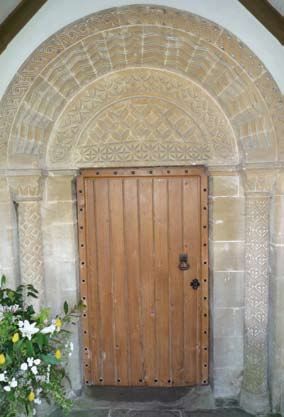
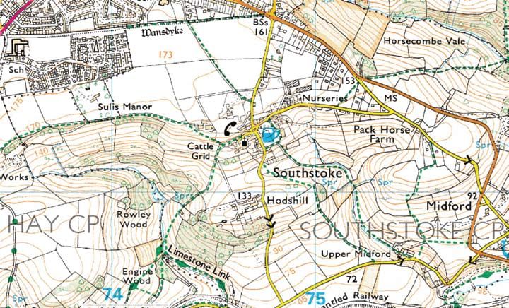
Modern OS map of South Stoke

Assessment of Special Interest
Location and Setting                      deeply set with characteristic high     interior of the Conservation Area
The village and Parish name of            banks that meander freely across        that is otherwise hidden from view
South Stoke derives from Old              the floodplains of these valleys.       and a link to the landscape beyond
English meaning outlying farmstead        They are also an important              from where its landscape setting
or hamlet, secondary settlement to        contributor to local natural heritage   and context can be viewed and
the south. It is one of many small        and biodiversity including fauna and    understood.
settlements to the south of Bath          flora.
that has been able to maintain its
historic rural character and              These steep river valleys provide a
tranquillity despite its proximity to a   striking landform on the southern
busy urban centre. As the name            most escarpment of the Cotswolds.
suggests, it is located just to the       The landscape has typically been
south of the City of Bath on the side     influenced by millennia of
of a small but steep river valley         agricultural activity and there is a
typical of this area within the           mixture of arable and pastoral land
Cotswolds Area of Outstanding             cover in roughly equal measure. The
Natural Beauty.                           irregular field patterns tend to be
                                          small to medium in scale, with
There are three main brooks that          hedgerow boundaries.
flow through these valleys: the Cam
and Wellow brooks merge to form           There are principally two public        The village has a precipitous and
the Midford brook, which is a             footpaths within the Conservation       dramatic south facing position
tributary of the River Avon, and it is    Area: one to the west that joins the
the Cam that the settlement sits          Limestone Link national trail and
above. The landscape is                   another to the east that progresses
considerably influenced and               to the south. These paths offer an
characterised by these small brooks       interesting opportunity to view the

4
General Character and Plan Form          atmosphere and character of the          The absence of modern
The village possesses a nucleated        village.                                 development on the perimeter and
village green form with the route                                                 the way in which the village and the
through bisected by the Green,           Because of the position of the           landscape opens out before you to
which creates an interesting             village, built onto the south facing     the south as you enter from a narrow
circuitous route that necessitates a     slope of the valley, vistas are a key    and enclosed entrance creates a
slow passage through the village.        and important element of the             dramatic sense of arrival from the
For the most part it has a compact       character of the place and views         north. The juxtaposition and close
and close grained townscape with         beyond the village are uninterrupted     proximity of the village and city offers
some substantial buildings set within    by development of any kind. South        an intriguing and interesting contrast.
large grounds hidden from view by        Stoke has miraculously retained its      This, while not unique, is unusual for
trees and general plant growth. The      physical and emotional separation        a settlement so close to a large
route out of the village to the south    and historical and architectural         urban area but again is partly due to
descending into the valley below is      integrity despite its close proximity    the village ‘having its back’ to Bath in
remarkably steep and narrow              to Bath, an aspect noted by Nikolaus     being located on the side of a steep
providing a sense of drama and           Pevsner writing in the 1950s:            escarpment within a different valley.
atmosphere as one descends into
the countryside beyond the village.      ‘The happy sight of a village still
Having entered the village it is easy    entirely unsuburbanized, though only
to forget that there is a bustling and   two miles from the main station of a
busy city within close proximity, such   city’.
is the particularly peaceful rural

Landscape                                settlement having developed
The underlying geology originates        organically within the landscape and
principally from the Jurassic period     fitting into, and working with, its
and is dominated by Oolitic              contours, gradients and
Limestone typical of the Cotswold        geomorphology. This integration
range however the layers can be          with the landscape is further
summarised thus in descending            enhanced and augmented by the
order:                                   use of local limestone in the
                                         construction of the buildings
  Forest Marble                          including the Parish Church of St
  Great Oolite                           James the Great.
  Fuller’s Earth
  Inferior Oolite                        The surrounding landscape is also
  Midford Sands                          close grained with myriad
                                         patchwork of small irregular fields of
South Stoke sits within the              different shapes and sizes with
Cotswold Area of Outstanding             narrow steep sided lanes often
Natural Beauty (AONB) and                overhung with trees and lined with
represents its southern most edge        hedgerows. The surrounding fields,       The Conservation Area has an
and is in recognition of the             enclosed by hedgerow boundaries,         outstanding landscape setting within
outstanding and special quality of       have changed little since the            the Cotswold AONB
the landscape. It also provides a        mediaeval and post mediaeval
vitally important and crucial control    periods having not been affected by
for development that could be            the rationalising endeavours of the
potentially harmful to such a            Enclosure Acts of the 18th and 19th
sensitive area in terms of both its      centuries. In the valley below the
built and natural heritage. The          settlement there is evidence of
settlement is located just outside       mediaeval, possibly earlier,
the southern limits of the Bath          enclosure of water meadows
World Heritage Site but within its       described as ‘rich, wet grassland’.
immediate setting.                       There are also areas of ancient
                                         mixed deciduous woodland
Despite its close proximity to the       consisting typically of native species
suburban fringes of Bath the village     including ash and oak with willow        The buildings are typically constructed
feels entirely rural and distant from    and alder lining the river banks.        in local oolitic limestone
the city. There is a feeling of a
                                                                                                                            5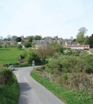
Historic Development                    estate lands of South Stoke, known
From the archaeological record (see     then as Tottanstoc, to Bath Priory, a
Archaeological Significance) that       Benedictine monastery of the
includes Bronze Age, Iron Age and       ‘Church of the Blessed Peter at
Roman pottery potsherds, including      Bath’. The estate later developed
Roman Samian Ware bowls, it             into the manor and parish and
appears that the site has been          remained in the ownership of the
occupied for thousands of years.        Priory until the Dissolution at the
The archaeological record from the      time of Henry VIII in the mid 16th
Roman period, as one might expect,      century. The development of the
is especially significant and Roman     manor would have given rise to the
villas have been discovered in close    settlement as we know it today and
proximity to the Conservation Area.     would have accommodated and
                                        provided the agricultural labour for
The settlement was later occupied       the manor estate and farm. The
in the immediate post-Roman             Manor Farm complex of buildings is
period by the Anglo-Saxons who          still in existence and constitutes an
were probably responsible for the       important heritage asset of the
construction of the West Wansdyke       Conservation Area’s historic
on the northern boundary of the         character and environment.
village possibly in the late 8th or
early 9th century. It is thought that   There is, however, no explicit
this formed a physical earthwork        mention of South Stoke in the
boundary between the kingdoms of        Domesday Book of 1086 and
Mercia and Wessex. Later Edgar,         therefore its inclusion remains          The ornate Norman north doorway
King of Wessex and crowned King         somewhat obscure. It has been            to the Church of St James
‘of the whole land of Albion’ at Bath   suggested that its 5 hides were
in 973, in a charter of 961 gave the    implicitly included in the 20 hides of

OS first edition map of 1885

6
Bath or the 9 hides allotted to          churchwardens commented that the         anecdotally evidenced by such
Monkton Combe although both              Crown was a negligent absentee           reactions as the one expressed by
assertions are merely educated           landlord whose neglect of South          Nikolaus Pevsner, included above.
conjecture. What is clear, however,      Stoke had resulted in the decay of       More objectively it is worth noting
is that Norman culture impacted on       the Church. Further destruction to       that in the 1801 census the
the settlement and this is evidenced     the church was caused by the Great       population of South Stoke was
by the ornate north doorway of the       Storm of 1703 and the                    calculated as being 188 (95 males
Church of St James the Great,            churchwarden’s accounts of the           and 93 females) and has merely
dating from between 1160 and             time record the subsequent               approximately doubled since that
1170.                                    repairing of the Church.                 time. The parish as a whole was
                                                                                  noted as possessing just 42
Following the Dissolution in the         The village has undergone some           dwellings at this time and although
1530s the Manor and its property         changes from the mediaeval period        this has obviously increased, the
were acquired by the Crown rather        onwards and has witnessed                village has experienced only minor
than being sold to private wealthy       development in each subsequent           modern 20th century development
landowners, as was the case with         century, but the overriding              mainly along the ridge. In the
much of the monastic property at         impression is one of continuity and      Conservation Area there are
this time. In 1555 the                   containment. This continuity is          approximately 60 dwellings.

Activity and Former Uses                 author of the first geological map
The settlement owes its                  and regarded as the ‘Father of
establishment to the fact that the       English Geology.’ There does not
surrounding area afforded the right      appear to be any evidence as to
and appropriate conditions for           whether either route had a significant
agricultural activity for all types,     impact on the economy of South
including fertile soils for arable and   Stoke or its development.
meadows and pasture for the rearing
of sheep and cattle. The existence of    There is documentary evidence of a
Roman villa sites, which were            brewery at the village in the 18th
essentially farm houses, is also         century. However The South Stoke
testimony for the favourable             Brewery was established in the
agricultural conditions. As with most    1830s and constituted an important
other settlements South Stoke’s          industry in the village which has left
economy was principally agrarian         its architectural mark with a number
until the latter part of the twentieth   of extant buildings in the village.      Part of the Manor Farm complex
century. The Manor Farm and other        These include the vaulted storage
farms in and around the                  cellars which front on to Packhorse
Conservation Area are testimony to       Lane which were used for the storing
this and provide historic physical       of beer barrels. The brewery, having
evidence. Interestingly the Tithe Map    suffered long-term major decline,
of 1840 shows four long fields where     finally closed in about 1909 and
Plough Field is now situated just to     some of the associated buildings
the north east above Springfield         were demolished in 1921.
Nurseries and provides clear
evidence that strip farming was          The mining of Fuller’s Earth was an
practiced in South Stoke.                important industry in and around
                                         South Stoke with extensive fulling, or   The brewery vaults of the
The Old Post Office and Slipway          tucking, mills at nearby. Midford and    former South Stoke Brewery
were formerly the post office,           was an intrinsic element in the
grocer’s and butcher’s although have     success of the woollen industry
since been converted to dwellings.       throughout the Cotswold region. The      advantage of the fertile south facing
                                         South Stoke quarry, opened in 1886       slope for horticultural propagation
The Somersetshire Coal Canal,            and closed in 1894, was an open          and market gardening in the late
constructed at the end of the 18th       cast quarry situated just to south of    19th and early 20th centuries.
century in 1795 just to the south of     Hodshill.
South Stoke, was to be later                                                      The church, community hall and The
superseded by the GWR branch line        To the east there are the remnants of    Packhorse public house, all of which
railway, which followed the route of     the former Clifford’s Nurseries which    are centrally located, provide for
the canal for much of its length. The    was an important local employer          vibrancy and hint at an active
canal surveyor was William Smith,        within the Parish that took full         community.
                                                                                                                     7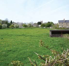
Archaeological Significance             Fishponds have been identified as
                                         South Stoke is rich in archaeology      being of mediaeval origin also to the
                                         and there is a significant              south of the village. Much of the
                                         archaeological potential within the     discovery and finding of this
                                         parish. The most important              archaeological record has come
                                         archaeology is arguably the             about from incidental activities over
                                         presence of the West Wansdyke,          the last 200 years although there
                                         which is a substantial linear           has been some limited
                                         earthwork of Anglo-Saxon origin         archaeological field work and
                                         and a Scheduled Ancient                 excavation undertaken by early 19th
                                         Monument situated just to the north     century antiquarians and latterly in
                                         of the settlement and, being the        the late 20th century. Therefore it
                                         northern boundary of the Parish,        can be concluded that there is a
                                         provides a physical boundary            considerable archaeological
                                         between South Stoke and Bath. The       potential in and around South Stoke
                                         Wansdyke as it proceeds through         that should inform all future
                                         Bath has been unfortunate in having     development.
                                         been severely compromised by the
                                         modern development of suburban          There is also an industrial
                                         expansion.                              archaeological presence in the form
                                                                                 of the remains of the disused
                                         Predating the Wansdyke is an            Somersetshire Coal Canal that lay
The Packhorse Inn and the Village Hall
together with the church are important   unsurprising and considerable           just to the south of the Conservation
social centres for the village           Roman presence including the            Area and also the GWR branch line,
                                         Fosse Way that runs just to the west    Limpley Stoke to Camerton Railway,
                                         of the settlement. One Roman villa      that superseded it and indeed it was
                                         site has been identified and two        largely constructed along the route
                                         other sites regarded as being           of the canal.
                                         possible sites from the
                                         archaeological record in and around     From the rich and significant
                                         the village: one to the east at South   archaeological record it is obvious
                                         Stoke House described as being of       that the archaeological potential is
                                         ‘high status’, one to the south east    considerable and this should inform
                                         at Southstoke Hall and another to       any decisions regarding future
                                         the west at Sulis Manor. Various        development both inside and
                                         artefacts have been discovered at       outside the Conservation Area. This
                                         these sites including carved            is particularly the case regarding the
                                         masonry such as columns and             West Wansdyke earth work, which
                                         capitals, sarcophagi complete with      has already been significantly
                                         human remains and grave goods of        compromised by previous
                                         Samian ware pottery. The last           development in the 20th century.
                                         excavation at these sites was in        South Stoke, therefore, should be
                                         2002. Samian ware and many other        regarded as a fragile and vulnerable
                                         items have also been found in           historic environment that requires
                                         gardens in the Conservation Area        careful consideration in all future
                                         and surrounding fields including        planning decisions.
                                         items from the Bronze and Iron
                                         Ages. Other Roman finds have been
                                         found to the south of the village at
                                         Hodshill.

8
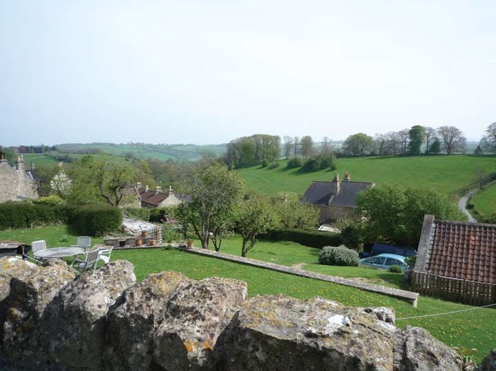
There are outstanding views into and out of the Conservation Area

Key Views and Vistas                       There are also outstanding views to
Because of the elevated position of        be had looking outwards from just
the Conservation Area, built on the        outside the Conservation Area from
side of a steep valley side, it            the Grove Path and from the
intrinsically benefits from                Millennium Viewpoint to the west
outstanding long range views to the        and outside of the Conservation
south and into the valley below.           Area.
There are countless positions within
the conservation Area where one            The principal views into the
can experience these views. The            Conservation Area are to be had
principal view points are from the         from Hodshill where the setting of
southern part of the churchyard, the       the compact village and
Green, the north east corner at Pack       Conservation Area can clearly be
Horse Lane, Old School lane from           seen. This view is important to
the Packhorse Inn which affords a          understanding the setting of the
medium range view into the valley          Conservation Area and how it might
and from the far west of the               be compromised by development
Conservation Area, which affords           ‘spillage’ from Bath. From this
medium range views to the north            position its setting and landscape
and long range views to the south          context can clearly be viewed. Both
west and also views of the western         of these external vistas illustrate the
edge of the Conservation Area.             short distance between Bath and its
                                           importance in maintaining the
                                           compact form of the village and its
                                           particular and separate historic
                                           identity.
                                                                                     9
South Stoke Conservation Area

                                                                               C
                                                                    House

                                                            ngs
                                                       ildi
                                                     Bu

                                                ge
                                              an
                                       e   Gr            tage
                                                              s
                                    Th               Cot

                                                                   Horse Inn
                                                                       e In

                                Stable
                                S                         Pack Horse
                                                          Pac
                                              of St
                                              James
                                              J
                                              Ja mess                          Sc
                                              tthe
                                                 eGGreat
                                                   Grea
                                                      at
                                                                  Snowdrop

10
High
Fair
Cotta
ge
HORSE
Barn
r
lou use
Cottage
age Parrmho
Bee
Beech Fa
Christmas
The
Th se
use
Southstoke
Villa
ge
ol Cottagess
cho
Old
Key
Rose
Cottages rds Listed buildings
he
ep
Sh
Locally important buildings
Important green spaces
Important views
Landmark buildings
Conservation area boundary
Proposed Conservation
area boundary
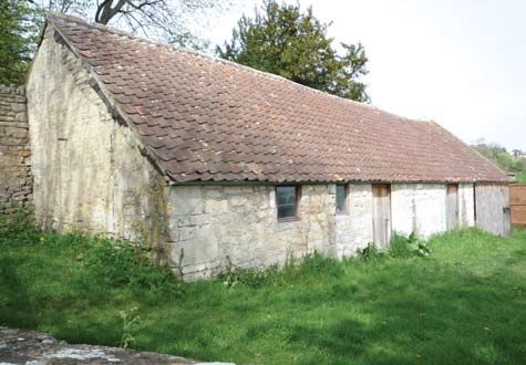
11The prevalent building style is mainly modest 2-storey cottages interspersed with more substantial, grander buildings which provides for an attractive variation in character Architectural and Historic Qualities of the Buildings The Conservation Area benefits beautiful and atmospheric historic The predominant building material is from a good number of attractive environment. The Church has a local Oolitic limestone and the listed buildings which include the strong visual connection to the architectural style is typical for the Manor Farm and farm complex Manor Farm and other buildings in region which could be described as which has some extremely this area and forms a very important Cotswold vernacular dating typically interesting and rare survivals such grouping occupying a prominent from the 17th century. There is as the 15th century tithe barn, late position from the centre to the some architectural variety, however, 16th century dovecot and early 19th western edge of the Conservation with the presence of some century horse engine house. The Area. substantial polite classical buildings farmhouse itself dates from the and Gothic style Regency and early 17th century. The Parish The Packhorse Inn has a date of Victorian villas. However the Church of St James the Great, 1674, although it has been predominant style is modest constructed of local limestone, suggested that it incorporates an 2-storey cottages. The use of local dates from 1160 to 1170 and has an earlier building possibly of limestone rubble in the construction outstanding ornate carved arch over mediaeval origin. It is a typical of boundary walls and in many of the north door. The church has Cotswold style building with attic the buildings is ubiquitous, much of typically undergone changes gables, relieving arches and drip or which is exposed natural stone throughout its history right up to the hood mouldings above the although the earlier buildings would mid-Victorian period. There are windows. It is a former farmhouse have been either lime washed or some outstanding churchyard originally named The Breath, lime rendered. The general form of monuments many of which are although it seems likely that this is a the buildings is low rise with many listed in their own right. The misreading of “Breach” meaning small short terraces which follow churchyard is interesting in the way land newly broken up by ploughing, the contours on the valley slope. the north and west sides are closely and became a public house in the Roof materials vary with some slate, bounded by the backs of some very mid 19th century. This building, some local Forest Marble stone tiles attractive small cottages called The along with the Manor Farm and which are still in existence on the Grange at the Manor Farm with no Parish Church, is an important and Manor Farm buildings and the back yards, gardens or boundary significant building within the Church of St James but the walls. This results in an unusually Conservation Area. predominant material is clay domestic sense of enclosure to the pantiles. church and a feeling of intimacy to a 12
A more substantial building to the       The Priory is another significant and
east is Southstoke Hall constructed      prominent building in the middle of
in Bath limestone. It was originally a   the Conservation Area dating from
small building dating from medieval      1850 in a Tudor Gothic style and,
times constructed around a               although it differs significantly with
courtyard. It was added to in the        the small scale local vernacular
17th and 18th Centuries and an           buildings, it is an impressive
ashlar facade was added to the           building.
south facing front of the building in
c.1800 at the same time as the east      Priory Cottage, adjacent to The
wing was added. It has an                Priory, is a mid 18th century barn
interesting building at the entrance     conversion and is more typical of
named The Lodge dating from the          the local vernacular with ovolo
mid 19th century in a Gothic style       mullion windows, timber casements
decorated with idiosyncratic             and rendered finish to the walls.
carvings of green men and
grotesques.                              The iconic historic K6 telephone
                                         kiosk occupies an prominent central
The Stable House, originally the         position just to the western edge of
stables to Southstoke Hall, is an        the Green and constitutes an
attractive building from the late 18th   important element of the historic
century.                                 public realm and street furniture.

The Brewery House, which                 The churchyard has many highly
occupies a prominent position            interesting, outstanding and unusual
within the centre of the village just    monuments one of which is on the
above the Green, was built for the       B&NES’ Buildings at Risk Register.
owner of the former South Stoke
Brewery. This is a Regency Gothic
Revival villa dating from 1820 to
1830 and has stucco rendered finish
and typical crenellated parapet
detailing.

                                                                                  13
Locally Important Buildings To the south there are The Parish
There appear to be many unlisted Hall and a number of very attractive
buildings dating from the 17th 18th cottages such as:
and 19th centuries, which are
mostly small cottages built of local Packhorse Cottage
limestone, in the Conservation Area Snowdrop Cottage
that can be regarded as possessing Sunny Side
architectural historic merit and as Rose Cottages
such make a considerable School House
contribution to local distinctiveness. Malthouse Cottage
There are many houses and Ivy Cottages
cottages to the north and north Old School House
eastern corner that provide a good Russell Cottages
example of this including: Victoria Cottages
Packhorse Cottages
South Knoll Courtmead
Hillside Cottage Shepherds Mead
Quoin Cottage
Upper Cottages The cottages just to the east of the
The Old Post Office and Slipway churchyard, Russell Cottages and The locally important buildings make a
(see the “Slipway” relating to the Victoria Cottages, form an attractive significant and positive contribution to
historic footway at the eastern group and contribute positively to the character of the Conservation Area
edge of the Green and the setting of the Church and Manor
Opportunities for Enhancement Farm. Within the Manor Farm
and Recommended Management building complex there is an
Proposals) outstanding granary style of building
The Old Vicarage centrally located and a barn or cow
Brewery Cottage shed to the north west corner
Longhope although these buildings are
Pound Cottage protected by being within the
Beech Cottage curtilage of the Manor Farm.
Chestnut Cottage
Barleybrake It is clear that some of these
buildings may warrant being listed
in recognition of their architectural
historic merit and heritage assets
and they may be, therefore, worthy
of further investigation as part of the
management proposals.
14Trees and Green Spaces Opportunities for Enhancement
Trees are an important feature of the Although the Conservation Area is
Conservation Area particularly obviously well cared for there are
within the boundaries of the more however some opportunities for
significant buildings such as the enhancement and indeed the
Manor Farm, Southstoke Hall and community has already undertaken
The Old Vicarage. Species in these some important work. For instance
areas include mature Cedar and a the removal of telephone poles and
plethora of beech and other the relocation of cabling
deciduous species. underground. This has had an
extremely positive impact on the
The small gardens in the village, particularly in the centre
Conservation Area are mostly around the Green. Further telephone
attractive and charming cottage pole removal is being planned by
style gardens planted with classic the community and the Council
varieties and vegetable plots. These would greatly encourage this.
gardens are often framed by ‘cock
and hen’ limestone walling and on To the west of the Green there is a
an incline and constitute an defunct water trough that could be
important element of the character rebuilt using local natural stone
of the Conservation Area and make which would be an attractive central
a very positive contribution. focal point and bring the noise of
moving water which would create
The presence of inappropriate tree an attractive ambience in an area
species, such as Leylandii, is limited much used by the community.
and instead there is an abundance
of appropriate deciduous broad leaf The Green itself is an important
trees including many native species. central feature and focal point much
used by the community and visitors
The Green is centrally located and although there are some minor
as such is an important feature and improvements that could be made.
visually ‘softens’ the hard surfaces For instance there has been some
that dominate this part of the planting with domestic plant
Conservation Area. The churchyard varieties that detract somewhat
also constitutes an important and from the traditional character of the
attractive green space that also Green and their removal would
affords outstanding views. improve its appearance.
The two footpaths within the There are some utilitarian tubular
Conservation Area to the east and steel handrails, for instance such as
west provide access to important those that are situated on the
green spaces. The footpath to the Slipway, which could be replaced
east is lined with mature tree with those of a more appropriate
species such as substantial style, and also on the southern side
chestnut trees and affords glimpses of the main access to the Packhorse
into attractive formal gardens and Inn, which adversely affect its
hedge bounded fields. The footpath setting. The frontage to the
to the west, known as the Grove Packhorse Inn would generally
Path, is bounded by soft verges benefit from improvement works in
Green spaces are an important element
of the Conservation Area with a thick tree canopy and leads order to enhance the setting of this
to the western extremity of the important building within the
Conservation Area where are Conservation Area.
outstanding views to the south west
and into the Cam Brook valley. The Slipway that runs to the eastern
edge of the Green is an attractive
The grounds to Southstoke Hall and and interesting historic footway
the Vicarage offer significant and although it has been much
attractive green spaces within the neglected in recent times and as
Conservation Area and make a such inhibits use by pedestrians.
positive contribution to its setting. This requires considerable
15improvement in order to make it
more useable for pedestrians and
also to return it to its former and
original condition as an important,
attractive and useable historic
feature. It should be noted that the
community has entered into
discussions with the Council
regarding this matter having
identified it is a priority for works of
enhancement within the
Conservation Area.
Many of the boundary walls have
been re-pointed using cement and
any future work should be
encouraged to use lime mortars to a Modern development and
colour that matches the local suburbanisation has had a negative
limestone. Boundary walls are impact on the Conservation Area
traditionally constructed in dry
stone style, indicative of the
Cotswold region, and any new or
replacement walling should be
constructed with reference to this
vernacular style.
Negative Areas General Condition
The modern development at the The condition of the South Stoke
northwest of the Conservation Area Conservation Area is generally
occupies a prominent position and excellent and it is obviously a village
deviates considerably from the style that is being greatly cared for which
and character of many of the is a result of considerable local
historic buildings in the village. They community pride. It has been able
are of an architectural style that is to retain its separate and individual
having a negative visual impact on identity and rural atmosphere
the Conservation Area and notwithstanding its very close
adversely affects the setting of proximity to the outer fringes of
adjacent and significant historic Bath. Importantly this has been the
buildings such as the church and case since its beginnings as a
the eastern part of the Manor Farm. settlement approximately 1500
Their open and prominent position years ago.
exacerbates their negative impact
as do the garages built into the Apart from one churchyard
bottom of the slope that they monument there are no other
occupy. buildings at risk within the
Conservation Area. Generally the
There are a number of historic condition of historic buildings,
buildings, some of which were traditional walling and other
former agricultural buildings which surfaces and green spaces can be
have undergone insensitive considered to be in excellent
conversion and have been condition.
somewhat suburbanised and fitted
with inappropriate doors and
windows including plastic. This not
only affects the buildings but also
There are some opportunities the setting of adjacent buildings and
for enhancement the Conservation Area.
16Recommended owners of Ivy Cottages should be
encouraged, when replacing
Management doors and windows, to use
appropriate design and materials
Proposals and in order to reinstate the original
Boundary Changes appearance of what should be a
unified terrace. Where there are
surviving original doors such as
The modern development just to
the right hand door in the image
the north of the church as
above these should be replicated
discussed above constitutes one
and there removal discouraged.
of the most significant negative
This attractive terrace could be
features of the Conservation
further improved for instance by
Area. As such careful
replacing the hard standing to the
management proposals should
front with a more appropriate
be put in place to mitigate its
surface treatment
impact. However in the long term
this may be regarded as an
There are some unlisted historic
opportunity site for good quality
buildings that should be
redevelopment
Ivy Cottages form an attractive terrace considered for being listed
The utilitarian tubular steel of locally important buildings that have
undergone insensitive alterations that The community has instigated
handrails in evidence throughout
have had a negative impact on their and undertaken the removal of
the village should be removed
appearance such as inappropriate many of the telephone poles and
and replaced with some of a
modern replacement doors and cables which has been installed
more appropriate style. Indeed
windows. The door on the right of the below ground. This has had a
there are existing historic
photographs is the original door. significantly positive impact on
examples which could provide
the setting of the Conservation
guide to an appropriate style for
Area and therefore the removal of
the replacements
the remaining poles should be
greatly encouraged
The Slipway historic footway The use of modern materials
requires considerable such as cement should be
The Green has been planted with
improvement and following discouraged when considering
some inappropriate domestic
investigations and research this repair to historic buildings and
garden varieties which detract
should be restored to its former boundary walls. Where cement
from its central community and
original condition using local has been used in the past owners
civic function. The removal of
craftsman and locally sourced should be encouraged, when
these species would improve the
materials. It is noted that there is appropriate, to replace this with
appearance of this important
considerable community support lime based mortars
green space making it more
for such a scheme and indeed
appropriately open and
preliminary proposals have There are some historic buildings
accessible as a community
already been put forward that have been fitted with
meeting place and leisure area
inappropriate plastic windows
and these are discordant with the
The defunct village water trough
traditional style and construction
to the west of the Green should
of the buildings. The result is that
be reinstated using local
they have a detrimental affect on
craftsman and locally sourced
the building and the setting of
materials
listed buildings and the
Conservation Area as a whole.
Any future boundary treatments
Owners should therefore be
should consider the local
encouraged to replace or
Cotswold vernacular style of dry
reinstate them with traditional
stone walling with cock and hen
timber windows and should be
capping
regarded as improvements that
will have significant benefits not
The front of the Packhorse Inn
least regarding issues of
sustainability. For instance, the
17Article 4 Directions could be ‘…an area of special architectural or
implemented to safeguard the historic interest, the character or
traditional style of the doors and appearance of which it is desirable
fenestration of the unlisted to preserve or enhance’.
buildings
The quality and interest of the area
The setting of the village and its as a whole, rather than individual
Conservation Area is an intrinsic buildings, is the main consideration
and highly important element of when designating such areas.
its character and the visual
Brantwood
envelope that it is contained Designation introduces a general
within should be preserved Nurseries, and they form an control over the demolition of most
attractive group of historic buildings, and tree felling/surgery.
The churchyard of St James buildings that contribute to the The scale of extensions that may be
church has a chest tomb that is character of the Conservation added to existing dwellings as
on Bath and North East Somerset Area. Furthermore this site from “permitted development“ is also
Council’s Building at Risk where the former nurseries limited. Designation has some
Register (BARs) and would operated contributed to the resource implications for the local
benefit from some careful and social, economic and cultural life authority and owners and occupiers
sensitive conservation of the village and can be of property within the area because
regarded as a significant aspect of increased statutory controls and
of its later historic development. particular requirements for the
2011 Conservation The buildings are regarded as repair or alteration of existing, and
Area Boundary making a positive contribution to
the Conservation Area
construction of new buildings. For
most owners however these
Changes implications are outweighed by the
cachet of designation, and the
Reassessment of conservation area Community tendency of controls to enhance the
boundaries is one of the purposes
of an appraisal and as such the
Involvement value of property within the area.
Designation also provides the basis
boundary has been amended to for policies designed to preserve or
Public support and involvement is
include: enhance all aspects of character or
essential to the successful
appearance that define an area’s
management of conservation areas
The area to the northwest to special interest.
and as such this first draft has been
include the entire estate and
sent to the South Stoke Parish
parkland of Brantwood House, Section 71 of the Act requires the
Council for comments and
which is an outstanding and local planning authority to
consideration. Furthermore the
significant historic building in the periodically formulate and publish
preparation of this draft has already
spirit of the Arts and Crafts and proposals for the preservation and
been undertaken with the kind and
of a Jacobean style utilising local enhancement of conservation areas
helpful assistance of individual
materials and architectural within the district. Section 72
members of the Parish Council who
detailing. It is set within requires that in considering
have provided invaluable assistance
substantial and attractive applications for development in a
and excellent advice and
grounds and ornate gardens Conservation Area, attention shall
suggestions.
which contain some significant be paid to the desirability of
tree species including a mature conserving or enhancing the
Cedar. When viewed from the Planning Policy character of that area.
south at Hodshill it is apparent
that Brantwood is part of the Context Conservation Area appraisals are
village and makes a positive considered by English Heritage to
contribution to the Conservation A Conservation Area is designated be vital to the conservation of these
Area under the provisions of Section 69 special areas. The content of this
of the Planning (Listed Buildings statement is based on the
To the north east along and Conservation Areas) Act 1990 suggested approach set out by
Packhorse Lane there is a group and local planning authorities are English Heritage.1
of substantial late Victorian and required to determine which parts of
Edwardian villas which were its area are areas of special Change is inevitable in most
associated with the former architectural or historic interest. A conservation areas. The challenge is
nurseries known as Clifford’s conservation area is defined as: to manage change in ways that
1 Guidance on conservation area appraisals (2006) and Guidance on the management of conservation
18 areas, English Heritage (2006)maintain and reinforce an area’s
special qualities. Inappropriate
environment. The Council’s
emerging Local Development
General Guidance
development and increases in Framework (LDF) is being prepared and Policy
motor traffic on narrow country within the context of national
lanes are some of the things that planning policy. The Core Strategy Saved policies from the Bath &
can negatively impact on is the key policy document for North East Somerset Local Plan
conservation areas and therefore B&NES Council and will put in place 2007
need to be avoided if the character the strategic planning framework to Bath & North East Somerset,
of rural conservation areas is to be guide change and development Living in a Conservation Area,
maintained. once adopted. It will include broad 2003
policies relating to the built and Bath & North East Somerset
South Stoke is recognised as a rural historic environment. Streetscape Manual, (Adopted
settlement located within the April 2005)
statutory Green Belt where the More detailed planning policies Archaeology in Bath and North
policy towards significant levels of regarding the historic environment East Somerset: Supplementary
new development is restrictive. This are to be found in the Bath and Planning Guidance 2004
purpose of the Green Belt is clearly North East Somerset Local Plan, Rural Landscapes of Bath and
of the utmost importance to the which will be ‘saved’ until replaced North East Somerset: A
integrity of the South Stoke by the Council’s LDF. Landscape Character
Conservation Area. Assessment, Adopted as
It had been expected that the new Supplementary Planning
Furthermore South Stoke is situated LDF should be consistent with high Guidance 2003
within the Cotswolds AONB and as level regional spatial strategies. The Avon Historic Landscape
such there are significant controls relevant regional spatial strategy Characterisation Methodology,
and policy designations of the envisaged a significant increase in Chapman, 1997
Cotswolds AONB Management Plan new housing and employment Cotswolds Area of Outstanding
that also apply to planning control in development at Bath which have Natural Beauty Management Plan
the Conservation Area. the potential to impact on rural (2008-2013)
areas on the fringes of the city. At Guidance on Conservation Area
The location of South Stoke within the end of May 2010 however the Appraisals, English Heritage,
the setting of the Bath World Government announced that it 2005
Heritage Site is also a contributory would abolish regional strategies Guidance on Conservation Area
factor in the need to preserve and and return decision-making to local Management Plans, English
enhance the area. The UNESCO Councils. The need for housing in Heritage, 2005
Report on the management of the the locality however remains, and Conservation Principles: Policies
Bath World Heritage Site recognises the Government is expected to & Guidance – for the Sustainable
the need in paragraph 7 of its develop proposals for affordable Management of the Historic
decision paper ‘to enhance the housing in certain parishes. Environment
protection of the surrounding Therefore a need remains to ensure Planning Policy Statement 5:
landscape of the (World Heritage that the setting of the Conservation Planning for the Historic
Site) to prevent any future Area is recognised and protected. Environment
developments which could have “Analysis of Conservation
adverse and cumulative impact Potential” – the original Wansdyke
upon the Outstanding Universal Council map defining the existing
Value of the World Heritage Site’. Conservation Area as designated
in 1982
The legislation for Conservation The 1984 revision to the Statutory
Areas runs parallel with general List of Buildings of Special
planning legislation and there will be Architectural or Historic Interest.
a need to ensure that appropriate Bath & North East Somerset
linkages are in place under the new Local Plan 2007
regime. Bath World Heritage Site Setting
Study: Information Paper 2009
Planning Policy Statement 5: Avon Historic Landscape
Planning for the Historic Characterisation (1995)
Environment (PPS 5) sets out
national planning policies regarding
the conservation and the
preservation of the historic
19Further Reading Glossary Contact Details
The Book of South Stoke with Listed Buildings: Buildings on the Bath & North East Somerset Council
Midford: The History of a Parish Statutory List of Buildings of Special Planning & Transport Development
ed Robert Parfitt (2001) Architectural or Historic Interest PO Box 5006
compiled by the Secretary of State Bath
Rural Landscapes of Bath and for Culture, Media and Sport under BA1 1JG
North East Somerset: A the Planning (Listed Buildings and
Landscape Character Conservation Areas) Act 1990 Telephone: (01225) 477000
Assessment, Supplementary
Planning Guidance, April 2003 Conservation Area: Defined by Further contact details can be found
English Heritage as ‘areas of special on B&NES Council’s website:
The Archaeology of Avon: A architectural or historic interest, the www.bathnes.gov.uk
Review from the Neolithic to the character of which it is desirable to
Middle Ages, ed Michael Aston preserve or enhance’. Some Contact for advice regarding:
and Rob Iles, Avon County permitted development rights are
Council removed for owners of buildings in Listed Buildings and Listed
a Conservation Area and special Building Consent
Buildings of England: North planning controls may apply Archaeology
Somerset and Bristol, Pevsner, Conservation Area Consent
N. (1958) Article 4 Direction: A direction Works to trees within
under Article 4 of the Town and Conservation Areas
Country Planning (General Planning Permission
Permitted Development) Order Planning Policy
1995. Article 4 Directions remove Urban Design
specified permitted development
rights and can be made to cover All the above teams are located in
parts of a Conservation Area where Planning & Transport Development
there is a clear and immediate based at offices in Bath.
threat to the amenity of the area
Historic Environment Record
(HER): This is a database of
heritage assets and historic and
archaeological monuments and
administered by B&NES. The
information is primarily used as a
planning tool for desk top
assessments for the historical and
archaeological significance of sites
Tree Preservation Order (TPO):
An order made by a Local Planning
Authority in respect of trees or
woodlands to prohibit works to
trees without consent (part VIII of
the Town and Country Planning Act
1990 and the Town and Country
Planning (Trees) Regulations 1999)
This document about the South Stoke Conservation Area can be made available
in a range of community languages, large print, Braille, on tape, electronic and
accessible formats from Planning Services on 01225 394100
Prepared by Bath & North East Somerset Council Planning Services.You can also read