Auranga Town Centre - Economic Analysis - May 2020 - Prepared by Karaka and Drury Ltd in support of a sustainable Centres Plan for Drury West & ...
←
→
Page content transcription
If your browser does not render page correctly, please read the page content below
Auranga Town
Centre - Economic Analysis
Prepared by Karaka and Drury Ltd in support of a sustainable
Centres Plan for Drury West & Auckland South

May 2020
Prepared by Urbacity
DISCLAIMER: The information contained within this document forms the Auranga Town Centre Economic Analysis prepared on behalf
of Karaka and Drury Ltd. It has no binding effect of itself but is intended to assist the planning process to facilitate the development of
Drury generally. Information contained in this document is provided in good faith and is believed to be correct at the time of printing.
However, the statements or representation contained in it should not be accepted as statements of fact nor should it be capable of universal
application. Karaka and Drury Ltd and its employees, agents or contractors shall not be liable to any person, whether though contract, tort
or any other legal or equitable obligation for any past, present or future loss or damage that may result from any implementation of or
failure to implement the material set out in this document.

FRONT COVER IMAGE: Drury Creek, Drury, Auckland

COPYRIGHT: © Copyright Karaka and Drury Ltd 2020 – Reproduction in part or whole by electronic, mechanical or chemical means
– including photocopying, recording or by any storage or information retrieval system in any language is strictly prohibited.
Auranga Centre Analysis
April 2020

                          Executive Summary
                          This report is in support of a Plan Change         catchment.
                          (Auranga B2 Private Plan Change).
                          The report focuses on the role of the           The operating geography of the Drury
                          Proposed Auranga Town Centre as a               area results in split catchments created
                          provider of retail goods and services for       by the State Highway (motorway) barrier
                          the growing Drury West catchment, and           and the Drury Interchange.
                          ultimately as an inspiration for a broader
                          employment strategy in Drury West that          The proposed Drury West (Auranga)
                          will deliver a more sustainable Auckland        centre sits between Burberry Road and
                          south.                                          Jesmond Road and in a timed sequence,
                                                                          eventually extends across State Highway
                          The proposed centre is urban, as it will be     22 and the rail line to encompass
                          built around streets - not as a mall. The       proposed business zoned land to the
                          basis of the urban strategy is to allow for     south. This land is poorly suited to
                          the wider range and diversity of jobs and       residential, being compromised by
                          dwelling densities that naturally accrue        floodways. The KDL work over the past 4
                          to urban centres. The ability to provide        years has highlighted the need for jobs in
                          these wider economic benefits has been          the south. The urban town centre’s retail
                          independently tested by Space Syntax            component is an early facilitator of jobs.
                          (London).
                                                                          At present, however, KDL seeks a zone
                          Context                                         for its land off Burberry Road and State
                          The comprehensively planned Auranga             Highway 22, to develop a supermarket,
                          Town Centre seeks to improve economic           specialty shops and other personal and
                          performance within Auckland’s south             professional services facilities. The centre
                          and to grow levels of self-containment,         will begin its early life as a convenience
                          thereby reducing pressure on the                centre for the growing Drury West
                          Motorways.                                      catchment but is ultimately to become an
                                                                          integrated, mixed-use town centre with an
                          The suitability of the location of the centre   extensive range of high-value jobs.
                          has been verified in extensive community
                          consultation and by Space Syntax. The           Centre Catchment Drury West
                          centre is in the most effective place.          Drury West FUZ is estimated to yield
                                                                          around 12,000 dwellings, but there are an
                          There are two centre opportunities for the      additional 700 dwellings outside the FUZ
                          Drury West and Drury Opaheke (Drury             that would find the Auranga Town Centre
                          East) area.                                     convenient. Currently being developed in
                          • A centre serving the east side                Auranga A & B, there are around 2,650
                             catchment.                                   dwelling sites. In and around Drury, there
                          • A centre serving the west side                were an estimated 2,115 households in

  4
Auranga Centre Analysis
                                                                                        April 2020

2018. With continuing growth, this is a threshold          its offer.
to start this centre with a single supermarket and
associated shops and activities.                           The Auckland Unitary Plan (AUP) Chapter B2
                                                           Urban Growth and form promotes a compact
Centre Status & Catchments                                 urban form, that enables higher productivity and
The motorway forms an effective barrier to                 economic growth. Proposed plans (such as this
movement between the east and the west in Drury            Proposed Plan Change request) should seek to
and assists to define the catchments for centres.          expand the economic capacity and productivity of
Beyond 2028, residential development will occur in         growth areas to enable communities to be as self-
Drury East. As this growth continues, it is expected       sufficient as possible. An urban town, rather than a
that a centre will develop in Drury East.                  shopping centre is a fundamental basis for improved
                                                           economic performance. The Proposed Plan Change
Papakura to the north of the area and on the east          represents the start of this capability in Drury West.
side of the motorway is a Metropolitan Centre. Its
catchment reach will extend to Drury and beyond.
The Proposed Auranga Town Centre would be
subservient to Papakura.

Drury Rail Station & Employment
The urban nature of the Auranga Town Centre and
structure design of the Auranga masterplan offers
an extension of the employment lands across the
rail line to the south, focused on the rail station. KDL
sees this area as an urban extension of the Auranga
Town Centre. The network allows for simplification
of access from the Town Centre (the zone subject to
this Plan Change request) across the rail line using
existing crossing points. Space Syntax modelling
highlights the value and performance of these links
in creating employment.

Effects
The Plan Change request provides for the daily and
weekly needs of an existing and growing catchment.
In the short term, it will also reduce travel for these
services from residents in Drury East and West.

Existing centres in the area are at Pukekohe
(approx. 13 kms south of the proposed site),
Papakura (approx 7kms north of the proposed
site) and Drury local centre (approx 2 kms from the
proposed site). Papakura will benefit from growth in
Drury West, which will favour resources provided in
Papakura at the Metropolitan level. The proposed
Auranga Town Centre is at a different level in the
hierarchy and is seeking to service growth, not
existing catchments of existing centres. There are
unlikely to be any negative effects on Pukekohe, but
over time the Drury local centre may need to modify

                                                                                                                  5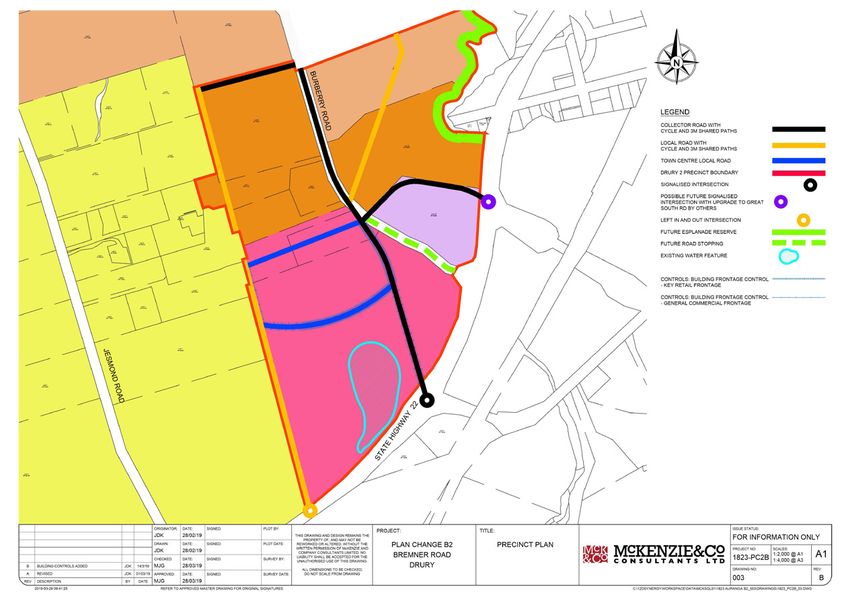
Auranga Centre Analysis
April 2020

                                  Table of Contents
                     EXECUTIVE SUMMARY ______________________________________________________    4

                     1      Background _____________________________________________________     8
                            1.1    Auranga Town Centre                                           8
                            1.2    Auranga Town Centre Site Location Influences                  9
                            1.3    Other Potential Town Centre Sites                             10
                            1.4    The Rail Station & Employment                                 12

                     2      Catchments & Centres _____________________________________________   15
                            2.1    Housing Yields                                                15
                            2.2    Urban Centre Evolution                                        15
                            2.3    East & West Catchments                                        16
                            2.4    Growth, Jobs & Access                                         18
                                                                                                 25
                     3      Commercial Demand & Land Use_____________________________________    24
                            3.1   Retail Demand                                                  24
                            3.2   Retail Supply                                                  25
                            3.3    Jobs & Commercial Land Requirements                           26
                            3.4    Land Use Mix on Site                                          26

                     4      Assessment of Effects  _________________________________________     29
                            4.1    Demand for Business Land & the AUP                            29
                            4.2    Impacts on Other Centres                                      30
                            4.3    Urban Retail & Jobs                                           31
                            4.4    Impacts on Other Businesses                                   33
                            4.5    Impacts on Residents in the Area                              33

                     5      Conclusions     _______________________________________________      34
                            5.1     Growth                                                       34
                            5.2     Local Context                                                34

                            5.3    Regional Structure                                            34
                            5.4    Anchor Stores/Concepts                                        34
                            5.5    Effects                                                       34

  6
Auranga Centre Analysis
                                                                                                April 2020

List of Tables & Figures

       Figure 1: Auranga Town Centre Proposed Zone                                                                 8
       Figure 2: Simplifying the Network and Connecting the Rail Station                                           10
       Figure 3: Proposed Town Plan showing Link to Station and Jobs                                               10
       Figure 4: Space Syntax & Drury West Centres Analysis                                                        11
       Figure 5: Auranga Centre Assumed Early Catchment                                                            15
       Figure 6: Space Syntax Testing Town Centre Connections to Rail - Burberry to Great South Rd Link            19
       Figure 7: Hierarchy. Spatial Pattern of Current Metropolitan Centres - South                                20
       Figure 8: Drury West Area                                                                                   21
       Figure 9: Auranga Town Centre Comprising a Retail Core (Red) and Adjoining Business Land (Blue)             22
       Figure10: Auranga Town Centre Proposed Layout                                                               27
       Figure 11: Auranga Town Centre Comprising a Retail Core (Yellow Circle) and Adjoining 		                    32
       Business Land (Black Circle)

                                                                                                                   13
Table 1 - Auranga Analysis of TOD & Station Ped Shed Populations
Table 2 - FULSS Projections                                                                                        16
Table 3 - FULSS & KDL Analysis by Development Stage Drury West & East (within the FUZ)                             16
Table 4 - Current Catchment Populations & Catchment Growth & Sequence Estimates                                    17
Table 5 - Auranga Town Centre - Projected Retail-Core Evolution                                                    22
Table 6 - Market Economics Assessment of Jobs in Drury West                                                        23
Table 7 - Average New Zealand Retail Spend Profiles                                                                24
Table 8 - Total Drury West Retail Spend                                                                            25
Table 9 - Estimate of Extent of Land Use Areas                                                                     27

                                                                                                                          7
Auranga Centre Analysis
April 2020

              1 Background
                                The purpose of this document is to outline the rationale for an
                                urban town centre in Drury West (Auranga Town Centre). This
                                section outlines previous work on development yields, employment
                                and assumptions about centre locations and hierarchies.

                          The proposed Drury West (Auranga) centre sits between Burberry Road and Jesmond
                          Road and in a timed sequence, eventually extends across State Highway 22 and rail
                          line to encompass proposed business zoned land. Karaka & Drury Ltd (KDL) work over
                          the past four years has highlighted the need for jobs in the south. An urban (street-
                          based) town centre’s retail component is a facilitator of employment. The eventual
                          Auranga Town Centre is urban (street-based) crosses the rail line and is over 100 ha in
                          size, with a diverse mix of high-density housing and employment.

                          KDL seeks a zone for its land adjacent to Burberry Road and State Highway 22, to
                          develop a supermarket, specialty shops and other personal and professional services
                          facilities. The site comprises approximately 33.65 hectares of land (see Figure 1).

                          Figure 1: Auranga Town Centre - Proposed Zone

                                                                               1.1 Auranga - Town
                                                                               Centre
                                                                               The centre will begin life as
                                                                               a convenience centre for the
                                                                               growing Drury West catchment.
                                                                               Ultimately, the proposed centre
                                                                               will become an urban (street-
                                                                               based) facilitator of an integrated,
                                                                               mixed-use town centre with an
                                                                               extensive range of high-value
                                                                               jobs. The development approach
                                                                               by KDL is that the centre is urban
                                                                               - not inward-facing as research
                                                                               shows that urban centres deliver
                                                                               more jobs than shopping centres
                                                                               and at higher wage levels.

                                                                               Research by Urbacity shows
                                                                               that urban (street-based)
                                                                               centres generate five times the

  8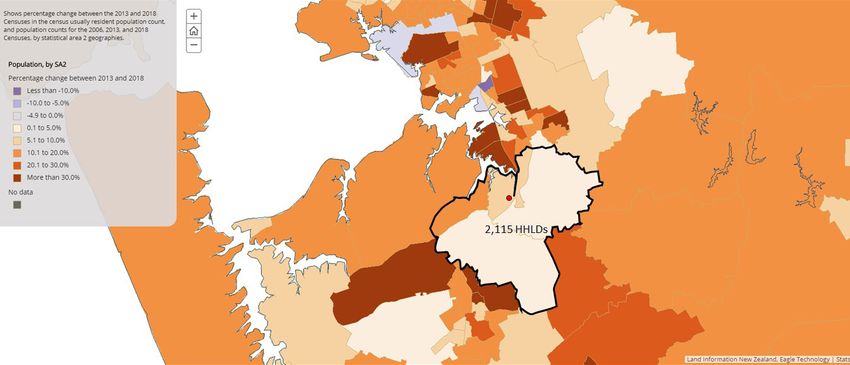
Auranga Centre Analysis
                                                                       April 2020

non-retail employment (higher value employment) of shopping centres and overall much
larger employment totals than shopping centres. In other words, street-based towns are
employment-heavy and pay higher wages than shopping centres. When built, Auranga will
be the first urban town in NZ for over 100 years.

The Auranga Town Centre and its potential to attract employment provides the following
benefits:

•   To take the pressure off Auckland’s motorway system
•   To increase levels of self-containment (goods and services and jobs) in the south of the
    city
•   To complement the city’s major airport
•   To reduce trips, travel distances and travel times in the south
•   To meaningfully increase the economic value and capacity of the south of the City
•   To improve the performance of rail by creating a multi-directional station tied to
    employment density as a centrepoint of the Auranga Town Centre
•   To increase public transport use by making the Auranga Town Centre a Transit Oriented
    Development (TOD)
•   To bring a sense of civic to the south through an urban, mixed-use town in a variety of
    complementary and culturally appropriate styles.

The Auranga Town Centre rail station location was fixed during a process in April 2019
by Penny Pirrit after consultation with landowners and others (Drury Opaheke Structure
Plan - Draft 2019). That Plan puts the station at a nexus with the Auranga Town Centre - as
indicated in Figure 3.

1.2 Auranga Town Centre Site - Location Influences
The proposed Auranga Town Centre sits within the Drury West growth area. This area is
functionally well defined to its east, due to the barrier of the Motorway, the congested Drury
Interchange and access difficulties within the Drury local centre. The proposed Auranga
Town Centre catchment is ultimately and predominantly contained within this Drury West
area.

Urban design and desired economic outcomes drove the choice of location of the proposed
centre:
• The site is toward the eastern edge of Drury West so is best positioned to pull traffic
   heading north from the arterial. Centre catchments work best with a “home domain”
   pattern of flow. Home domain is the direction in which most traffic is heading for
   employment and the purchasing of goods and services;
• The town seeks to ultimately transition across the State Highway to unlock the economic
   capacity of the land to the south in and around the proposed rail station;
• The site, with slight local network modifications, uses existing infrastructure to connect
   both sides of the rail and doesn’t need additional and expensive infrastructure
   investment to tie both sides of the rail line together (see Figures 2&3);
• The site is of sufficient size to accommodate growth and deliver additional social and
   economic benefits to that of a shopping centre;
•       The site has the requisite regional and local road hierarchy capable of supporting an

                                                                                                 9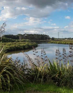
Auranga Centre Analysis
April 2020

              urban town centre.

              Figure 2: Simplifying the Network and Connecting the Rail Station

                                                                                  The realignment of Burberry
                                                                                  Road to connect directly to
                                                                                  McPherson Rd (as shown
                                                                                  adjacent) removes the current
                                                                                  unsafe offset arrangement
                                                                                  between the two intersections
                                                                                  at McPhersons and Great South
                                                                                  Road.

                                                                                   Independent assessment of site
                                                                                   and context performance was
                                                                                   undertaken by Space Syntax
                                                                                   (London). Their modelling and
                                                                                   conclusions are available if
                                                                                   requested, but show in diagram
                                                                                   form in Figure 4. A benefit of
              Burberry Road (over Jesmond Road) is that it can be modified to connect directly to the south
              side of the rail line at no cost to the public. This link will improve the potential for the town centre
              to grow to the south, to envelope the town’s proposed rail station (see Figure 3).

              Consultation took place with the community via a series of open days and via the internet in
              2017. The community were offered were several location options for the town. The preferred
              location for the town centre from the consultation was on the subject site (see the possibilities
              tested with the community as Attachment 14 in Ian Munro’s Urban Design Assessment).

              Figure 3: Proposed Town Plan showing Link to Station and Jobs

  10
Auranga Centre Analysis
April 2020
1.3 Other Potential Town Centre Sites
A high level, cross-Auckland study was undertaken looking at growth and transport. The
Transport for Urban Growth (TFUG) study proposed a town centre at the south-western
extremity of the FUZ in Drury West away from the major north-south and east-west networks.
This proposition appeared to determine station separation as the motivator of centre location.
Centre location is never driven by rail station dynamics. Indeed rail stations often prove
anathema to retail performance. Rail station patronage is also unsupportive of retail demand,
and so co-location of stations and centres are for reasons other than for retail. Rail station
location in outer Metro locations is usually either housing-focused, with rail passengers
leaving in the am peak and returning in the pm peak, or jobs focused with workers arriving in
the am peak and departing in the pm peak. The TFUG station had no employment capacity
outside of retail.
Space Syntax modelled the broader network to assist KDL to understand the dynamics
affecting centre location and performance. The Space Syntax model showed how poorly the
Oira centre would perform. The centre is located some distance off the major network and
appears located to coincide with station separation distances.
The Space Syntax diagram below shows that an Oira centre would have the same minor
accessibility benefits as Auranga’s small Bremner Road Centre.
The key in the bottom right-hand corner of the diagram is important. Both the Bremner Road
centre (small circle) and the Oira centre are identical in terms of the influence of movement
on each centre’s role. Oira could only be a local centre (small circle), whereas the Auranga
centre is structurally integrated at multi-scale for its role as a town centre (large circle).
Figure 4: Space Syntax & Drury West Centres Analysis
11Auranga Centre Analysis
April 2020
The Auranga Town Centre location ultimately seeks to use the urban qualities of the zone to
encourage an urban transition across SH22 and the rail line, capturing the rail station and
engaging the land south of the rail line for employment-dominant activities. This land was
assumed in TFUG to have a poor housing yield due to flooding (which may have encouraged
the movement of the station) however the land is suited to employment uses, which is
more accepting of these land constraints. As employment is the most critical sustainability
objective for fringe-urban growth (not housing or retail), the town centre zone provides the
basis for a longer-term, employment-heavy, town centre definition. The transition, though, will
be at least one maybe two decades in the making.
1.4 The Rail Station and Employment
The basis of Peter Calthorpe’s Transit Oriented Development (TOD) principles has not
always been understood by planners who often see it as a means of increasing public
transport use. Calthorpe and sustainable transport planners like Robert Cervero (UC
Berkeley) propose TODs as a means of reducing trips, not of growing trips out of an area by
public transport. Together, the Auranga Town Centre and its rail station can form a TOD.
The core principle of a TOD is to facilitate employment so that people do not have to leave
the area.
A residential development strategy around the station would make it an outbound station
(for residents). As likely travel distances are long, this would remove passenger capacity for
residents closer to the city, who would be taking shorter trips. As an inbound station (workers
coming to the Auranga Town Centre) the likely trip distances will be shorter - making both the
TOD and the network more sustainable.
Efficient TOD stations work as origins and destinations for rail trips. That two-way flow
proposition is only possible at the Auranga Town Centre station. Trains full in one direction
and empty in the other are a reflection of poor land use and transport planning, where the
jobs are at one station and the houses at another.
A quality urban environment forms the basis of the character for the Auranga Town Centre.
The quality of the urban environment to deliver a TOD is essential for two main reasons:
Universal walkability is important for TOD stations as well as urban centre performance, and
therefore the quality of the journey to the station is an influence of TOD catchment size;
Attractive buildings and spatial intimacy catering to human-scale environments increase the
demand for mixed-use, which also improves walkability to stations.
Research shows that people will walk twice as far to rail stations when there are shops on
the journey. Space Syntax has shown where these shops can occur within the town centre
(and on both sides of the rail line).
In terms of public transport performance, Newman and Kenworthy showed that with per ha
population densities under 30 there is an exponential increase in private motor vehicle use.
Newman and Kenworthy have estimated that 35 persons per ha is a reasonable basis for
12Auranga Centre Analysis
April 2020
rail1.
TOD performance is a function of the level to which pedestrian flows are likely (and designed
for) within the wider TOD area. TODs are pedestrian-focused. Retail-dominant centres are
car-focused.
The population yield describes pedestrian accessibility (Ped Sheds) for rail stations within a
1-kilometre radius of the station. Based on Newman and Kenworthy’s research, a Ped Shed-
typical 300 ha area should yield a minimum of 35 persons per ha. Estimates of the land use
yields of the potential TOD and Station Ped Sheds are in Table 1 below.
Table 1 - Auranga Analysis of TOD & Station Ped Shed Populations
Auranga TOD Auranga TOD
Population (est)
Core Retail Area 1,500
Employment Area 6,000
Apartments and Other Housing 2,000
Est Total TOD Population 9,500
Land Area Ha(Gross) 180
TOD Persons per ha 53
Station Ped Shed Area (Ha) 300
Net Additional Population est 5,000
Station Ped Shed Persons per ha 48
The yield analysis shows the potential of the Auranga Town Centre to be rail-supportive.
The core retail component of the Auranga Town Centre sits between Burberry Road
and Jesmond Road and in a timed sequence, the land use orientation will transition to
employment to extend across State Highway 22 and the rail line to encompass the land to
the south (as shown in Figure 3).
The Town Centre proposition reflects the need for towns to evolve. Non-retail employment
lags retail employment, and so recognising the sequence is necessary for the centre’s
planning and economic strategy. The influence of the sequence is growth, urban form, built
form, growing the extent of public realm quality and vibrancy.
Auranga technical work over the past 4 years has highlighted the need for jobs in the south,
which is reinforced by technical submissions by organisations such as Infrastructure NZ.
Space Syntax modelling also highlights the commercial value of the Burberry Road
connection to McPherson Road and the continuing potential to Great South Road (see
Figures 4 & 7).
1 Newman and Kenworthy. Cities and Automobile Dependence (1989); An International Sourcebook of
Automobile Dependence (1999); and the Millennium Database for Sustainable Transport (2001).
13Auranga Centre Analysis
April 2020
There are infrastructure cost savings through the use of existing connections via a realigned
Burberry Road and Great South Road connection to facilitate town centre to grow south,
as shown in Figures 3 & 4. All other potential Drury station locations east or west of the
motorway require additional government funds to connect both sides of the rail line.
Using the existing connections of McPherson Road and Great South Road will save in the
order of $15 million in government construction costs for a cross-rail overbridge somewhere
else (where the bridge cannot deliver an employment or density benefit).
14Auranga Centre Analysis
April 2020
2 Catchments & Centres
The purpose of this section is describe the dynamics that affect the role,
size, status and likely evolution of the Auranga Town Centre.
2.1 Housing Yields
The likely yield for Auranga’s currently approved two growth cells (Auranga A and B) will
be around 2,650+ dwellings. At this dwelling yield, plus existing homes in the area shown
in Figure 5 (approximately 2,115 households), a full-service supermarket and associated
specialty shops and offices is possible.
Figure 5: Auranga Centre Assumed Early Catchment
At the current level of dwelling productivity on the west-side, the likely residential yield of
Drury west will be around 12,000 dwellings. As the threshold dwelling yield for full-service
supermarkets begin at approximately 4,000 dwellings, the Drury West area and rural area to
the west could eventually accommodate up to 3 supermarkets. As growth continues in Drury
West, the size of this centre will increase within the zone proposed.
2.2 Urban Centre Evolution
The form of the centre’s retail, commercial and community component is likely to start as
single storey buildings with the occasional signature two-storey building holding the key
corners. This approach allows the town to “bank” not only service areas (in the form of at
grade car parks) but also lower-scale buildings are easier to demolish and replace with
higher intensity buildings as the demand grows for more commercial space.
Development of commercial/retail buildings will take approximately 50% of the net retail land
15Auranga Centre Analysis
April 2020
area, with parking taking the other 50%. At the early stage, the town centre will be serving
predominantly retail and local commercial service demand within a small catchment, as
discussed above. Therefore, the form of early development will be relatively inefficient in
land utilisation. Also, early, low-scale development does not have the financial capability to
deliver decked or underground parking.
A growing catchment will inspire the town’s development evolution, and more intensive
use of land becomes feasible with single and two-storey buildings replaced by taller and
more dense development. Car parking areas can be built within structures, and their
former sites redeveloped for more productive activities.’
2.3 East & West Centre Catchments
State Highway 1/Motorway is a constraint to east-west movement. Most of the growth of
housing and population will occur to the west of the Motorway. Below are figures produced
in Council’s Future Urban Land Supply Strategy (FULSS) studies. These figures largely
formed the basis of Council’s services requirements, which influenced sequencing. KDL
was able to design and then negotiate service agreements that allowed Drury West to
come forward in the Council’s sequencing program. The amended FULSS was adopted
by Council and all of Drury West within the FUZ was recognised as being available for
development by 2022.
Table 2 - FULSS Projections
Initial FULLS FULSS Refresh Initial FULLS FULSS Refresh
Opaheke Drury E Opaheke Drury E Drury West Drury West
Area ha 1,200 1,149 950 1,031
Dwellings 8,000-9,500 8,200 6,100 - 10,800 11,200
Jobs 5,500 unknown 1,000-3,450 unknown
The two FULSS documents vary slightly in dwelling numbers. Generally, the East yield has
reduced in the two analysis periods, and the West has increased. As stated earlier, KDL
believes that total dwelling yield in Drury West will increase from 11,200 as indicated in the
FULSS refresh, to around 12,000. KDL is also well through the civil and site analysis that
gives greater certainty over yield per ha. That analysis, when applied to the land in Drury
East with the same density as being achieved in Drury West suggests that dwelling yields
in Drury East will be substantially lower than the 8,200 assumed in the FULSS (see Table
3 - KDL figure in red).
Table 3 - FULSS & KDL Analysis by Development Stage Drury West & East (within the FUZ)
FULSS Refresh KDL
Drury West Stage 1 (North of SH17) 5,550 7,500
Drury West Stage 2 (South of SH17) 5,650 4,500
Total Drury West 11,200 12,000
Opaheke/Drury (south) 8,200 4,400
Opaheke/Drury (north) - 1,300
Total Opaheke/Drury 8,200 5,700
Opaheke/Drury as % of Drury West 73% 43%
16Drury Opaheke
Centres Analysis
March 2019
As shown, KDL expects dwelling yields in Drury East to be around 5,700, less than half the
yield of Drury West.
The estimated 2018 Census population for Drury East and West is around 3,500 people.
The assumed catchment for the Auranga centre allows for trade east of the motorway as
a centre in the east is some time away. With the development of a centre to the east, the
eastern portion of the assumed catchment will then focus on that centre.
Conversely, the catchment definition assumes a supermarket at Paerata and nor does it
account for an assumed 900 households in Drury South.
Before the completion of an eastern centre, substantial development and housing formation
will occur in Drury West and also in Paerata and Drury South. The Auranga centre will cater
to that growing residential market. Figure 3.shows the assumed catchment.
Development of the centre will initially be retail-focused or retail dominant to serve
the growing catchment, as retail demand precedes commercial demand and demand
for housing density. Typically, centres in growth areas start slightly ahead of optimum
catchment size. The market will determine the timing of the centre, but the first stage can
happen now.
The ultimate catchment for this centre will be around 12,700 households or 33,000 people
(based on the unlikely assumption that the FUZ never moves westward). The catchment
comprises all of the Drury West Future Urban Zone (FUZ), plus existing households
outside the FUZ to the west and south as indicated above. The east side catchment
ultimately will be catered to by a centre in the east. Therefore, populations in the east that
initially use the Auranga Centre will transfer to the eastern centre.
In summary, the proposed Auranga centre’s catchment is likely to have a dedicated
population of around 33,000. Table 3 shows a likely catchment sequence for the Auranga
centre.
Table 4 - Current Catchment Populations & Catchment Growth & Sequence Estimates
Population Households Population Households Population Households
Location
2018 2018 2035 2035 Post 2035 Post 2035
Wider Catchment
Ramarama 1,917 669 - -
Drury 1,197 363 - -
Drury Rural 2,763 936 - -
Kingseat/Karaka (part) 433 147 - -
Total Population &
6,310 2,115 - -
Households
Growth Areas
Paerata (est) - - 7,800 3,000
Drury South (est) - - 2,340 900
Drury West (est) - - 15,600 6,000 33,000 12,700
Drury East (est) - - 2,600 1,000
Auranga Local Centre
- - 28,340 10,900 33,000 12,700
TA est
Source: Statistics NZ Census 2018, Urbacity, Auckland Council
17Auranga Centre Analysis
April 2020
The table shows how a sequence of growth and the development of new centres in both
Drury East and Paerata will affect catchment for the Auranga Centre pre and post a nominal
2035. The choice of 2035 as the transition year is arbitrary. It could be earlier or later, and
growth could be more or less in this period. The table is not supposed to be an accurate
indication of the amount, location and sequence of growth but rather an indication of how
the sequencing of growth and the development of centres in Drury East and Paerata might
affect the catchment for the Auranga centre over time.
The proposed Auranga Town Centre is to begin life with a supermarket and specialty shops,
food and beverage services and personal and professional services and possibly a CoWork
Hub. Ultimately, this centre should grow to include offices and high-density residential.
2.4 Growth, Jobs & Access
In Drury West and Opaheke-Drury, the centres that provide the most influence over
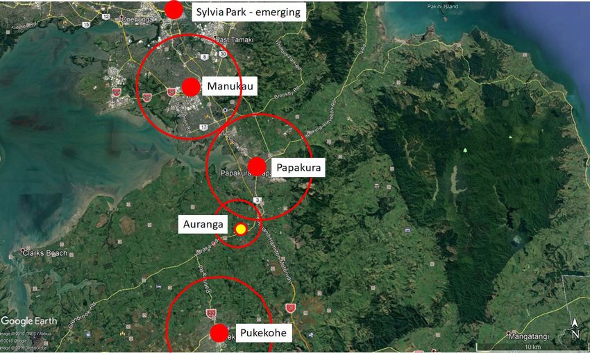
centre roles in the new growth areas (FUZ) are Papakura and Pukekohe. Papakura is
a Metropolitan centre and Pukekohe a Town centre in the Auckland Unitary Plan AUP.
Papakura is around 5.4 kilometres from Drury (and is influential for Drury West and East in
terms of centre role), and Pukekohe is approximately 13.2 kilometres from Drury and is less
influential.
The Unitary Plan defines Metropolitan centres as “second only to the city centre in overall
scale and intensity...” It is appropriate that growth should support the role of Papakura, and
that competition in Drury should be complementary to its function.
The role of Drury centres have been evaluated based on the following criteria:
1. Locations of future residential populations
On the west side of the motorway, there is an estimated capacity for around 12,000
dwellings in the Future Urban Zone plus an existing 700 dwellings outside of that zone
making a total of 12,700. In addition to this figure, there are a proposed 6,000 new jobs in
the widely defined Auranga Town Centre. Depending on the rate of development at Paerata,
there may be additional households at Paerata that will be catchment for the Drury West
centre. Paerata should be able to generate a supermarket-based centre when it completes
between 3,500 and 4,000 dwellings. Consequently, around 3,000 dwellings are available to
the catchment for the earlier centre at Drury west (Auranga centre) before the completion of
the Paerata centre and supermarket.
There is the capacity for around 7,900 dwellings (using our estimates and including Drury
South) in the Future Urban Zone, which a Drury East centre can serve. However, some
1,300 (estimated) dwellings are adjacent to Papakura. So that actual dwelling yield using
the above numbers is 6,600.
2. Regional Accessibility & Jobs
There is only one primary road link between the east and west sides of the Southern
Motorway in the Drury area – State Highway 22. It has significant congestion and limited
potential exists to take additional vehicle traffic through the Drury Interchange. Given
that the majority of the Opaheke Drury catchment and traffic movement is west of this
interchange it is appropriate to confine centre catchments to each side of this interchange
to reduce stress on the interchange. The Auranga centre will remove traffic from SH 22
before the interchange. Ultimately, the Auranga centre will reduce traffic flows out of the
18Auranga Centre Analysis
April 2020
Franklin area. Studies by Richard Paling Consulting in 2014 shows average commuter travel
out of Franklin is over 21 kilometres (compared to the Auckland average of 11.8 kms) with
more than 95% of these trips by private motor vehicle.
Space Syntax analysis shows that the proposed Auranga Town Centre site in Drury West has
excellent regional and local accessibility, reducing the need for longer travel distances.
“The greatest potentials for street-based retail in the Town Centre are on the north south
alignment of Burberry Road. This is because Burberry Road connects more continuously and
frequently into the wider movement network than any other alignment, gathering shorter- and
longer-distance movement and channelling it along its length.” Space Syntax.
Figure 6: Space Syntax Testing Town Centre Connections to Rail - Burberry to Great South Rd Link
3. Locations of Other Centres
The size of the market that will be served by each potential centre will be determined
significantly by the positions of existing and planned centres in the surrounding area.
Centres in Drury are subservient to Papakura and Pukekohe.
In the longer term, the market proposed to be served by the Auranga centre in Drury West is
the future population of this local area. This approach leaves the Council’s centre hierarchy
intact.
19Auranga Centre Analysis
April 2020
Figure 7: Hierarchy. Spatial Pattern of Current Metropolitan Centres - South
4. Market Size for Auranga Town Centre (Drury West)
The proposal is to develop a centre with at least one supermarket and associated shops
at Auranga between 2021-2023. The centre’s forecast main trade area will be the area
for which it is the most convenient centre. Planned local centres will limit the town
centre’s trade area at Hingaia to the north, and by the Paerata urban area to the south-
west.
Post-2028, the FULSS shows the development of Opaheke Drury East. When this area
delivers the requisite quantum of housing, the development of a centre can take place.
Until a centre opens in the east, the Auranga local centre will be the most convenient
local centre for residents of Drury East despite the constraints presented by SH 22 and
the motorway. Consequently, until a centre at Drury East is trading, the Auranga centre
will cater to existing residents of Drury East. After the Drury East centre opens, the trade
area of the first stage of the Auranga Town Centre will be limited to the west side of the
Southern Motorway.
Alongside Auranga A & B, the current populations in Drury west, Drury east and Drury
south, enable the development of the Auranga centre. Post-2028, when Drury east is
beginning to develop, the Drury east and Drury south catchment components will divert
to a centre in Drury east. Drury west catchment households will continue to grow to 2048
totalling around 12,700 dwellings (including households outside the FUZ) at build-out,
with an estimated 12,000 dwellings of this catchment will be within the Drury West growth
area, as shown in Figure 8.
20Auranga Centre Analysis
April 2020
Figure 8: Drury West
For employment-heavy town centres, there is limited capacity to accommodate a large
number of what retail consultants call “large format retail,” selling comparison (not everyday)
goods such as furniture, white good and electronics etc. Large format retail centres have
become an integral part of the retail scene. For town centres, other than such items in
department stores, large format retail tends to deplete the intensity of urban activity and
diminish the quality of the urban environment.
The Auranga centre would struggle to accommodate many of the tenants of a large format
centre (such as Harvey Norman, Noel Leeming, Briscoes, Rebel Sport, Freedom Furniture,
The Warehouse, etc). Similarly, hardware stores would be inappropriate in an urban town
centre. Larger format stores of the type mentioned above can be accommodated elsewhere
in Drury.
The Auranga centre could easily accommodate at least two supermarkets, a department
store (such as Farmers), and one other larger format store selling fashion or similar goods,
suited to an urban (street-based) environment.
The Auranga Town Centre Development Sequence (excluding infrastructure)
1. Develop the retail and services component of the town centre around the street network
and the town lake to a level of high amenity;
2. Develop high density housing around the town centre to reinforce the wider walkable
condition to and around the town centre and start developing a night-time economy;
3. Develop the second stage of the retail and service component of the town centre to
21Auranga Centre Analysis
April 2020
increase vibrancy;
4. Develop incremental office/Co-Work etc around the town centre to widen employment
opportunities and reduce jobs leakage;
5. Develop office sites within and adjacent to the town centre as the catchment grows so
as to take advantage of the proximity of the rail station;.
6. Facilitate a transition of employment to and around the rail station and on land more
suited to office and commercial development south of the rail station/rail line.
This proposal is for a specific site area of 15 ha, west of Burberry Road and The following
table outlines a possible sequence of retail development in the Auranga Town Centre.
Table 5 - Auranga Town Centre - Projected Retail-Core Evolution
2021-2022 2035 2048
Auranga Town Centre Space Estimates Est GLA Est GLA Est GLA
Est’d Town Centre Floorspace Sequence 7,000-10,000 10,000-15,000 25,000-30,000
- 1 supermarket plus specialties and services 3,500+/-
- 1 more supermarket plus specialties and services 3,500+/-
- 1 or more department stores plus specialties and services 6,000+/-
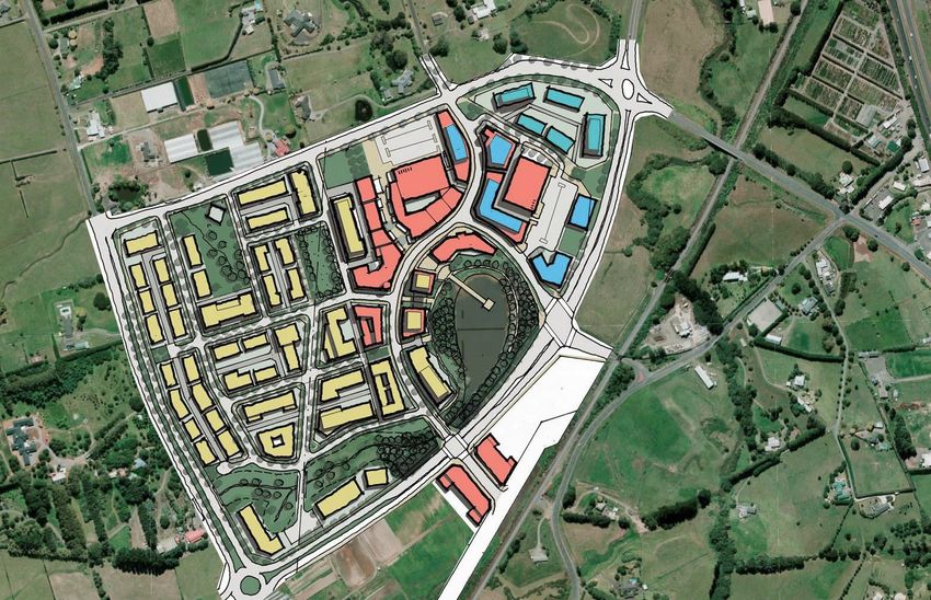
The town centre will develop around the existing lake on the site, as shown in the plan
below.
The retail core of the town centre would encompass the lake with the complete town centre
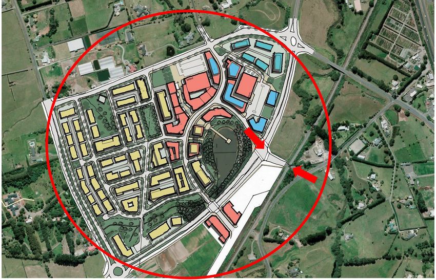
transitioning across State Highway 22 (Karaka Road) to commercial (office) and residential
accommodation in and around the proposed rail station, with the town extended on land
further to the south of the station (Figure 9).
Figure 9: Auranga Town Centre Comprising a Retail Core (Red) and Adjoining Business Land (Blue)
22Auranga Centre Analysis
April 2020
Auranga’s urban town centre is of the same family as other major urban centres in New
Zealand and is similar in its characteristics (but not necessarily status) to Newmarket,
Auckland CBD, Takapuna, Pukekohe, Hamilton etc. It is not similar to St Lukes, Sylvia Park,
Westfield Albany or any other retail-dominant shopping centre in New Zealand.
The Auranga Town Centre is proposed to be employment-heavy, not retail-dominant and its
streets and walkable spaces are to be public, not private.
In addition to its analysis and benchmarking, KDL appointed Market Economics (ME) to
undertake an assessment of jobs based on an earlier Masterplan for the Auranga Town
Centre with a slightly smaller business area/zone. Their assessment estimated 9,400 jobs,
with 7,000 of those jobs in the broader Auranga Town Centre (Table 6).
Table 6 - Market Economics Assessment of Jobs in Drury West
Employment Yield in FUZ Land Auranga + Business Park
Jobs
Auranga Business Land
Town Centre 928
Local Centre A 53
Local Centre B 53
Business Park 6,000
Total Auranga Business Land 7,033
Non-business land
Residential (home office etc) 1,585
Schools
Preschool 131
Primary 293
Secondary 303
Recreational 33
Religious 28
Total Non-Business land 2,373
Total Employment - Auranga Environs 9,406
Note: The term “Business Park” is used by ME. This area is a part of the Auranga Town Centre and is proposed
as urban, unlike a typical business park.
ME separated the land area into Retail (town) and Business Park (town). ME assessed the
size of the Business Park at 60 ha net, which is around 30 ha less than the proposed area
south of SH 22.
23Auranga Centre Analysis
April 2020
3 Commercial Demand & Land Use
The purpose of this section is review growth and the demand for retail,
commercial and community services.
3.1 Retail Demand
The first commercial stage of the town centre is its retail component. Demand for this activ-
ity aligns with growth and population threshold requirements of the supermarket operators.
The commercial component could, however, begin life as a comprehensive and well-de-
signed, high amenity, dining destination. Nevertheless, traditional lenders are less likely to
favour such a development response. This report assumes that the town centre will begin
life as a primarily retail destination and grow its mixed-use and residential density as the
values flow from urban vibrancy as the centre matures and expands.
There are unlikely to be any material influences over the spending power or behaviour pat-
terns of these residents that would affect or skew the retail or centre development strategy
given the size of the Drury West area is large (over 1,000ha).
For this retail floorspace assessment, we have assumed that these residents will generate
demand for around 2 square metres per person. Therefore, new residents in Drury West will
require 66,000 square metres of retail - somewhere. This projection is conservative as in
many New Zealand municipalities, the floorspace ratio per person is higher.
Around 30% of all New Zealand annual retail spend per capita is consumed in supermar-
kets and grocery stores (excluding motor vehicles, parts and fuel).
Table 7 - Average New Zealand Retail Spend Profiles2
Annual
Expenditure Category $ per capita
$2020
Supermarket & Grocery 4,284
Food & Beverage Services 2,415
Building Supplies, Furniture & Housewares 2,266
Department Stores, Clothing, Footwear & Accessories 1,856
Chemist & commission based retailing 1,543
Electrical goods, electronics & recreational goods 1,245
Specialised food and liquor 698
Total 14,307
The projected Drury West catchment population is 33,000. Table 8 shows spend projections
2 Dynamic Retail - An Overview of the New Zealand Retail Market, RetailNZ 2018
24Auranga Centre Analysis
April 2020
for Drury West residents at full build-out.
Table 8 - Total Drury West Retail Spend
Annual
Expenditure Category
$m $2020
Supermarket & Grocery 141.3
Food & Beverage Services 79.7
Building Supplies, Furniture & Housewares 74.8
Department Stores, Clothing, Footwear & Accessories 61.2
Chemist & commission based retailing 50.9
Electrical goods, electronics & recreational goods 41.1
Specialised food and liquor 23.0
Total 472
Source: RetailNZ. Urbacity, Auckland Council
Discussions with supermarket operators show that average economic throughput rates for
grocery stores is around $8,200 per square metre Gross Leasable Area (GLA). On that ba-
sis the Auranga Town Centre catchment would generate demand for 17,000 square metres
of supermarket floorspace. However, metropolitan markets are complex and so a major
portion, but not all supermarket expenditure, would be retained within Drury West.
There are smaller local centres within Drury West, with one already provided for on Bremner
Road. Likely the supermarket and grocery supply outside of the proposed Auranga Town
Centre would be between 4,000 and 5,000 square metres. Two or three supermarkets in the
Auranga Town Centre would total between 7,000 and 11,000 square metres, with only one
of these likely within the next 5-8 years. The timing of a second supermarket would depend
on the rate of growth in Drury West.
3.2 Retail Supply
As discussed earlier, the proposed town centre is to be urban or street-based, not a single
purpose shopping centre. The centre will grow and intensify over time.
As the urban qualities of the centre are fundamental to its long term evolution, it is inappro-
priate to include large format retailers such as furniture stores and hardware stores in the
centre as they compromise the intensity and vibrancy of urban centres. These retailers will
need to locate elsewhere in the area.
The likely first stage of the retail component of the town centre will comprise a single su-
permarket, associated specialty shops and services, around 7,000 - 10,000 square metres
GLA. The centre will grow to match catchment growth to around 25,000-30,000 square
metres GLA.
With the high likelihood of future growth beyond the FUZ, there is a further growth phase
possible beyond the FULSS timeline.
25Auranga Centre Analysis
April 2020
3.3 Jobs and Commercial Land Requirements
The ability to provide jobs in the south is fundamental to sustainability, as well as improved
physical and mental health.
Jobs provision should seek to reduce travel by providing the broadest possible range of jobs
close to or within Drury West. There are projected to be 13,800 new jobs with the addition
of the Drury South employment, for the projected 12,900 dwellings in Drury West and Drury
South. This total is around 89% jobs self-sufficiency for the new residents.
The West Franklin and Drury Future Business Land Assessment (June 2018), has assessed
that growth in the wider defined Drury catchment would facilitate a total requirement of
around 92 ha of commercially zoned land by 2048.
This report states that there is 20ha of vacant land in the “Karaka/Hingaia” node. This area
is not within the catchment for the proposed Auranga Town Centre and nor does it have a
primary relationship with Drury West. Karaka/Hingaia is more directly linked to Papakura.
This area has limited growth potential, and we see little association between the areas of
Drury growth and Hingaia.
The report’s catchment definitions might have appropriately referenced movement network
showing strong associations between Karaka Hingaia, the southern edge of Manukau
Harbour and Papakura - not Drury. We see little point in removing the 20ha of vacant
land from the Drury area as there is limited growth projected for Karaka/Hingaia and poor
access between the Drury growth areas and Karaka/Hingaia. However, after removing the
Hingaia land, the report concludes that the Drury catchment is still deficient by 72 ha in the
provision of commercial land by 2048. The report identifies the need for additional business
land in and around Drury. This land is required not only to service growth, which would only
deliver around one-third of the total employment requirement but also to generate a major
employment destination in the south to offset the dominant journey-to-work flows out of the
area to the north. As discussed earlier, an urban centre, with its start point as the zone that
is the subject of this Proposed Plan Change is influential in facilitating this outcome.
The report confirms previous KDL findings that the Drury East and West areas require
substantial commercial floorspace to reduce reliance on commercial and industrial locations
to the north.
3.3 Land Use Mix on Site
The proposed zone area for the town centre is 15.5ha. The Plan shows the general area
layout.
26Auranga Centre Analysis
April 2020
Figure10: Auranga Town Centre Proposed Layout
Table 9 provides estimates of land use areas at build-out within the proposed zone.
Table 9 - Estimate of Extent of Land Use Areas
Area Est
Land Use Element
ha
The Lake 2.0
Streets 4.0
Core Retail 3.0
Parking 3.0
Commercial 1.0
Housing 1.0
Community/Emergency Services* 0.5
Urban Square/Lake edges 1.0
Total 15.5
Note: The Core Retail area provides for around 25,000 square metres GLA, but includes
site and service areas not counted in the GLA. “Community” is child care, possible Council
service centre and/or library etc. This “Community” figure is a provision so could be larger or
smaller.
We have assessed the following categories of potential effects of the Proposed Town Centre:
27Auranga Centre Analysis
April 2020
1. The potential loss or gain of trade for nearby centres;
2. Levels of employment and goods and services self-sufficiency in and around Drury West;
3. Direct impacts on other businesses and centres;
- Whether businesses in the area are advantaged or disadvantaged by future activities
on the Site.
4. Direct impacts on existing and proposed future residential settlements in the area and
whether the Town Centre has a positive or negative influence on existing or proposed
residential areas in and around Drury;
5. Positive effects of the Proposed Town Centre and whether the Town Centre contributes
to the economy of the south and Auckland more generally.
28Auranga Centre Analysis
April 2020
4 Assessment of Effects
The purpose of this section is evaluate the effects of the Auranga Town
Centre on economic activity within the region.
4.1 Demand for Business Land & AUP
Urban towns outperform shopping centres in terms of economic output and in terms of
numbers of jobs and diversity of jobs. Research by Urbacity shows that urban (street-
based) centres such as Auranga generate on average five times the non-retail employment
of shopping centres as well as considerably higher total employment. This research also
shows that street-based towns pay substantially higher average wages than shopping
centres (studies on over 100 centres across Australia and New Zealand).
The Auckland Unitary Plan (AUP) Chapter B2 Urban Growth and form promotes a compact
urban form, that enables higher productivity and economic growth. This means that
proposed plans (such as this Proposed Plan Change) should seek to expand the economic
capacity and productivity of growth areas to enable communities to be as self-sufficient
as possible. An urban town, rather than a shopping centre is a crucial basis for improved
economic performance. The Proposed Plan Change represents the start of this capability in
Drury West.
By connecting the proposed Auranga Town Centre to rail, the significant economic
opportunity exists for the south side of the rail line to be rezoned to accommodate business
activity. A business zone here will offer improved performance for rail - with inbound
passengers in the am peak.
The alternative to this approach is a lack of proximate centres and associated business
land, resulting in departure of residents to other places in the city for goods and services
and employment. This pattern of development is known as sprawl.
The Proposed Plan Change is supportive of the AUP chapter on Urban Growth and form.
The AUP’s Business – Town Centre Zone H10.2. Objectives for all centres states:
1. A strong network of centres that are attractive environments and attract ongoing
investment, promote commercial activity, and provide employment, housing and goods
and services, all at a variety of scales.
2. Development is of a form, scale and design quality so that centres are reinforced as
focal points for the community.
3. Development positively contributes towards planned future form and quality, creating a
sense of place.
4. Business activity is distributed in locations, and is of a scale and form, that:
(a) provides for the community’s social and economic needs;
(b) improves community access to goods, services, community facilities and
opportunities for social interaction; and
(c) manages adverse effects on the environment, including effects on infrastructure
and residential amenity.
29Auranga Centre Analysis
April 2020
5. A network of centres that provides:
(a) a framework and context to the functioning of the urban area and its transport
network, recognising:
(i) the regional role and function of the city centre, metropolitan centres and town
centres as commercial, cultural and social focal points for the region, sub-regions
and local areas; and
(ii) local centres and neighbourhood centres in their role to provide for a range
of convenience activities to support and serve as focal points for their local
communities.
(b) a clear framework within which public and private investment can be prioritised and
made; and
(c) a basis for regeneration and intensification initiatives.
Business Town Centre Zone objectives
6. Town centres are the focus of commercial, community and civic activities for the
surrounding area and which provide for residential intensification.
7. The scale and intensity of development in town centres is increased while ensuring
development is in keeping with the planning and design outcomes identified in this
Plan for the relevant centre.
8. Town centres are an attractive place to live, work and visit with vibrant and vital
commercial, entertainment and retail areas.
9. Key Retail Frontage streets are a focus for pedestrian activity, with General
Commercial Frontage streets supporting this role.
Any regulatory instrument has not achieved the development of an urban centre in
Auckland within the past 100 years.
The Proposed Plan Change is most supportive of the AUP Chapter H10 Business - Town
Centre Zone.
4.2 Impacts on Other Centres
There are three centres within the influence of the growth area, except for the pending
Bremner Road centre that sits within the Drury West (Auranga) development area. The
centres are:
• Papakura (Metropolitan centre)
• Pukekohe (Town Centre)
• Drury (Local Centre)
The Proposed Plan Change is for a centre at the Town Centre scale. It will provide
additional resources for the current Drury community as well as growth within Drury West
(and initially south and east) as outlined in Table 4.
4.2.1 Papakura
The Papakura centre is at a higher level in the centre hierarchy within the AUP and so
its higher-order retail, commercial and community facilities will benefit from growth in
Drury. The Auranga Town Centre will not provide these higher-order facilities. Growth in
30Auranga Centre Analysis
April 2020
Drury West provides a growing market for these higher-order facilities within a town that
at present is struggling. The Auranga Town Centre is complementary to Papakura. The
only threat to the Papakura Metropolitan centre would be a major retail centre in Drury
that catered to a market that would be greater than that which is attributable to growth.
The retail component of the Auranga Town Centre is designed to serve the growth in Drury
West and will provide less than 50% of the demand for retail attributable to the Drury West
population. The balance of that demand will go elsewhere, including to Papakura.
4.2.2 Pukekohe
Pukekohe is some 13 kilometres from the proposed centre. The centre is of the same
status as the proposed Auranga Town Centre. Pukekohe would have a slightly larger core
retail catchment than the proposed Auranga Town Centre. We assess this catchment
at around 40,000. Pukekohe is a more mature centre with a significant component of
department store-type merchandise. The extent and diversity of mix in Pukekohe will
largely insulate it from any competition from the more convenience-based or supermarket-
focused mix that is the subject of the Proposed Plan Change. Also, the proposed Auranga
centre will be catering to growth - not seeking to provide for existing catchments of other
centres.
4.2.3 Drury
Three separate sites define Drury Local Centre, none of which are adjoining. The small
centre is focused on the immediate convenience needs of local residents and workers. The
mix of the centre includes a grocery store, pharmacy, café, butcher, fruit shop, hairdressers
and takeaways.
This centre will benefit to an extent from additional and substantial population growth in
Drury West, particularly from increased passing trade. Growth in Drury West and East may
require modification of the mix of the centre in future.
4.3 Urban Retail and Jobs
The Auranga Town Centre is the urban inspiration for a range of benefits only some of
which are economic. The New Zealand focus on “centre hierarchies”, which are in fact
not centre hierarchies but retail hierarchies has skewed the “economic” basis for centre
planning. Typically, economic analysis around these “centres” has been specific in its detail
to retail - not the ability of retail in an urban form to attract jobs.
The Urbacity studies mentioned earlier have found a nexus between urban streets
activated by shops facing streets and much higher levels of employment. However, the
economic benefits do not stop with employment. Urban centres are also attractive to
higher-density housing, whereas car parks and blank walls of supermarkets or shopping
centres are not.
Urban centres directly comply with and achieve the principles and objectives of the centre-
based provisions in the AUP. Shopping malls and centres do not. The Urbacity research
shows that for every two retail jobs in a shopping centre there is only one non-retail job.
In urban centres the non-retail jobs rise to five per two for retail. This is important for
economic productivity as retail and food and beverage services are the lowest paying
jobs in the economy (so why stop with just retail analysis). Planners and economists have
31You can also read