BUXTON SELF-STORAGE TOWN OF BUXTON SITE PLAN APPLICATION - Buxton, Maine January 2021
←
→
Page content transcription
If your browser does not render page correctly, please read the page content below

BUXTON SELF-STORAGE
              Buxton, Maine

TOWN OF BUXTON SITE PLAN APPLICATION

                January 2021

                Prepared for
                Patriot Holdings
             4023 Dean Martin Drive
              Las Vegas, NV 89103

                Prepared by
        Atlantic Resource Consultants, LLC
            541 US Route One, Suite 21
              Freeport, Maine 04032
Project Description
The proposed project is a self-storage business located at 488 Narragansett Trail in Buxton, Maine. The
subject site is identified as Map 6 Lot 44A from the Town of Buxton Assessing Tax Maps, and is zoned as
Business Commercial (BC). The site is approximately 10.68 acres and its current use is vacant residence
that has been demolished.

Article 8.2.B

8.2.B.1 – “The proposed use will not adversely affect the value of adjacent properties…”
         The proposed use is appropriate for the BC zone and will constructed in a manner that will not
adversely affect adjacent property values, as well as be a significant improvement from the abandoned
existing residential property.

8.2.B.2 – “Access to the site from existing and proposed roads is safe and adequate.”
        The proposed access to the site is located with over 600’ linear feet of site distance which
exceeds MDOT guidelines for site distance in a 45 MPH zone. By closing one of the two existing curb
cuts, confusion on turning and entering is eliminated.

8.2.B.3 – “Any proposed development is in conformance with all flood hazard protection
regulations”
       The proposed development is not within a known flood hazard, as evidenced by the attached
FEMA Flood Map.

8.2.B.4 – “Adequate provision for the disposal of all waste water and solid waste has been
made.”
        The proposed site will be serviced by a new subsurface waste water disposal site (see attached
HHE-200 prepared by Longview Partners, LLC) and will have solid waste hauled off by a private
contractor (or by the owner).

8.2.B.5 – “Adequate provision for the transportation, storage and disposal of any hazardous
materials has been made.”
        There will be no storage of hazardous materials on-site.

8.2.B.6 – “A stormwater drainage system capable of handling a 25-year storm without adverse
impact on adjacent properties has been designed”
        A proposed subsurface stormwater detention and treatment filter has been designed to
mitigate the stormwater runoff impacts associated with the development. The stormwater
management system has been designed in accordance with the MDEP Chapter 500 rules and
regulations, which requires a MDEP Stormwater Permit approval.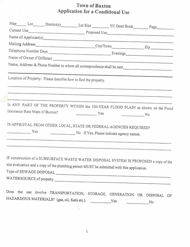
8.2.B.7 – “An erosion and sedimentation control plan has been prepared by a qualified
professional source.”
       Means and methods of controlling erosion and sedimentation, both during and after
construction, will be provided, both in MDEP review of the Stormwater Permit, and have been
accounted for in the design drawings.

8.2.B.8 – “There is adequate water supply to meet the demands of the proposed use and for fire
protection purposes.”
      A well has been proposed to serve the business office, which will be sufficient to handle the
demand of the employees. The storage units will not have water service.

8.2.B.9 – “That all performance standards in this Ordinance, applicable to the proposed use will
be met.”
        The proposed design meets the performance standards of the Ordinance.

Article 10 – Performance Standards

10.1 – Access to Lots
Access to the site occurs along the approximately 400’ of frontage and is 30’ wide driveway opening
with sufficient site distance for Narraganset Trail traffic.

10.2 – Dust, Fumes, Vapors, and Gases
Not applicable. There will be no creation of dust, fumes, vapors, or gasses as a result of the proposed
development.

10.3 – Erosion Control
See above.

10.4 – Explosive Materials
Not applicable. There will be no explosive materials stored on site as a result of the proposed
development.

10.5 – Construction in Flood Hazard Areas
Not applicable. The site does not lie within a flood hazard.

10.6 – Noise
There will be common traffic noise associated with the site. All heavy construction activities will be
performed between the hours of 7AM and 8PM.
10.7 – Off-Street Parking and Loading
Site parking and loading has been met with the creation of 4 (1 handicap) spaces for the office (1 space
per every 500’ or warehouse space) and ample parking and loading associated with the drive isles
associated with the storage buildings.

10.8 – Preservation of Landscape
The landscape will be preserved by the use of retaining walls to reduce grading impacts. A landscaped
front entrance will be provided to blend into the existing natural conditions and provide buffering
between the development and the Narragansett Trail frontage.

10.9 – Refuse Disposal
The management will maintain the site and assure proper waste disposal by hauling refuse away
directly.

10.10 – Setbacks and Screenings
The proposed site complies with all front, side and rear setbacks and will provide a landscaped buffer
along the Narragansett Trail frontage.

10.11 – Signs
One free-standing sign is anticipated to be placed (see drawing sheet C-101) near the entrance. All signs
will conform with the Town of Buxton Ordinances and will be subject to Code Enforcement review prior
to installation.

10.12 – Soil Suitability
A medium intensity soil survey provided by the Natural Resource Conservation Service is included along
with an HHE-200 form for the proposed on-site septic system.

10.13 – Stormwater Management
A Stormwater Management Report is included as part of the State of Maine MDEP Stormwater Permit

10.14 – Water Quality
No activity shall locate, store, discharge or permit the discharge of any treated, untreated, or
inadequately treated liquid, gaseous, or solid materials of such nature, quality, obnoxiousness, toxicity,
or temperature that run-oof, seep, percolate, or wash into surface groundwater so as to contaminate,
pollute, or harm such waters or cause nuisances such as objectionable shore deposits, floating, or
submerged debris, oil or scum, color, odor, taste or unsightliness, or be harmful to human, animal, plant
or aquatic life. An infiltration pond is proposed as part of the project and will minimize and sediment or
pollutants leaving the site.

10.15 – Archeological/Historic Sites
There are no known historic sites within the project boundaries.

10.16 – Lighting
There are no proposed exterior lights save for doorway and parking lighting mounted on the building.
The building mounted wall pack shall be a full cut-off fixture.

10.17 – Fire Protection
The project will meet all State and Federal fire protection requirements.

Attachment A – Application Form

Attachment B – Deed & P&S

Attachment C - Abutters

Attachment D – FEMA Flood Map

Attachment E – Soils

Attachment F – HHE-200 Form

Attachment G – Stormwater

Attachment H – Plan Set

ATTACHMENT A

6       44A                  BC              10.68 ac                   17144          279
             Vacant Residential - Demolished                    Commercial Self-Storage
                          Patriot Holdings
                      4023 Dean Martin Drive                       Las Vegas, NV          89103

                                                                         Jason Vafiades, PE
Atlantic Resource Consultants, LLC - 541 US Route One, Suite 21, Freeport, ME 04032 - 207-869-9050

From intersection of Route 22 Rout 4/202, head northwest on Route 4/202, site is approximately .3
 miles on the left.

                                                                              X

   X
  State of Maine Department of Environmental Protection Stormwater Permit

                                      On-site Subsurface WWDS
                                         Well

                                                                                   X
01/07/2021
ATTACHMENT B
DocuSign Envelope ID: 27FE6E13-6F8F-4F72-9545-7166E7656ED7
                      EDC319ED-9120-4BE7-8AC1-0B27F96A7D95

                       AMENDMENT TO CONTRACT FOR THE SALE OF
                             COMMERCIAL REAL ESTATE

                Patriot Holdings, LLC (“Purchaser”) and S&D Development LLC (“Seller”) entered into a
                Contract for the Sale of Commercial Real Estate (“the Contract”) with an effective date of
                October 27, 2020 for property located at 488 Narragansett Trail, Buxton, ME . Purchaser and
                Seller agree to amend the Contract as follows:

                1. Paragraph #5 DEED: the closing date for this property to take place upon obtaining Planning
                Board Approval for the construction of a self storage facility on the property on or before
                February 25, 2021.

                Except as amended above, the Contract shall remain in full force and effect, and Purchaser and
                Seller hereby ratify and confirm the Contract, as amended by this Amendment.

                This Amendment may be signed on any number of identical counterparts, including telefax
                copies, with the same binding effect as if all of the signatures were on one instrument.

                Seen and agreed to this 23rd day of December, 2020

                ______________________________________
                SELLER: owner/manager
                BY: Tom Soule

                                                 12/23/2020
                ______________________________________
                PURCHASER: manager
                BY: Jeremiah Boucher
ATTACHMENT C
ATTACHMENT D
ATTACHMENT E
Hydrologic Soil Group—York County, Maine

                           70° 31' 43'' W

                                                                                                                                                                        70° 31' 14'' W
                                                                                                       (Buxton Self Storage)

                                                376700                  376800                    376900               377000          377100         377200         377300
43° 37' 21'' N                                                                                                                                                                                     43° 37' 21'' N

                                                                                                                                                                                         4831000
                 4831000

                                                                                                                                                                                         4830900
                 4830900

                                                                                                                                                                                         4830800
                 4830800

                                                                                                                                                                                         4830700
                 4830700

                                                                                                                                                                                         4830600
                 4830600

                                                                                                                                                                                         4830500
                 4830500

                                                                                                                                                                                         4830400
                 4830400

                                                                                                                                                                                         4830300
                 4830300

43° 36' 53'' N                                                                                                                                                                                     43° 36' 53'' N

                                                   376700                   376800                    376900              377000             377100      377200
                           70° 31' 43'' W

                                                                                                                                                                        70° 31' 14'' W

                                                     Map Scale: 1:4,240 if printed on A portrait (8.5" x 11") sheet.
                                                                                                                            Meters
                                            N       0           50          100                       200                 300
                                                                                                                                      Feet
                                                    0            200          400                        800                        1200
                                                    Map projection: Web Mercator Corner coordinates: WGS84 Edge tics: UTM Zone 19N WGS84

                                            Natural Resources                                              Web Soil Survey                                         6/18/2016
                                            Conservation Service                                   National Cooperative Soil Survey                               Page 1 of 4
Hydrologic Soil Group—York County, Maine
(Buxton Self Storage)
MAP LEGEND MAP INFORMATION
Area of Interest (AOI) C The soil surveys that comprise your AOI were mapped at 1:20,000.
Area of Interest (AOI)
C/D
Warning: Soil Map may not be valid at this scale.
Soils
D
Soil Rating Polygons Enlargement of maps beyond the scale of mapping can cause
A
Not rated or not available misunderstanding of the detail of mapping and accuracy of soil line
placement. The maps do not show the small areas of contrasting
Water Features
A/D soils that could have been shown at a more detailed scale.
Streams and Canals
B
Transportation Please rely on the bar scale on each map sheet for map
B/D measurements.
Rails
C
Interstate Highways
Source of Map: Natural Resources Conservation Service
Web Soil Survey URL: http://websoilsurvey.nrcs.usda.gov
C/D
US Routes Coordinate System: Web Mercator (EPSG:3857)
D
Major Roads Maps from the Web Soil Survey are based on the Web Mercator
Not rated or not available projection, which preserves direction and shape but distorts
Local Roads
distance and area. A projection that preserves area, such as the
Soil Rating Lines
Background Albers equal-area conic projection, should be used if more accurate
A calculations of distance or area are required.
Aerial Photography
A/D This product is generated from the USDA-NRCS certified data as of
B the version date(s) listed below.
B/D Soil Survey Area: York County, Maine
Survey Area Data: Version 14, Sep 11, 2015
C
Soil map units are labeled (as space allows) for map scales 1:50,000
C/D or larger.
D Date(s) aerial images were photographed: Jun 20, 2010—Jul 18,
Not rated or not available 2010
Soil Rating Points The orthophoto or other base map on which the soil lines were
A compiled and digitized probably differs from the background
imagery displayed on these maps. As a result, some minor shifting
A/D of map unit boundaries may be evident.
B
B/D
Natural Resources Web Soil Survey 6/18/2016
Conservation Service National Cooperative Soil Survey Page 2 of 4Hydrologic Soil Group—York County, Maine Buxton Self Storage
Hydrologic Soil Group
Hydrologic Soil Group— Summary by Map Unit — York County, Maine (ME031)
Map unit symbol Map unit name Rating Acres in AOI Percent of AOI
HeB Hermon fine sandy loam, A 8.4 17.1%
3 to 8 percent slopes
Ra Raynham silt loam C/D 5.7 11.7%
Sc Scantic silt loam, 0 to 3 D 20.2 41.1%
percent slopes
SeB Scio silt loam, 3 to 8 C 11.8 24.1%
percent slopes
SkB Skerry fine sandy loam, 0 C 2.9 6.0%
to 8 percent slopes
Totals for Area of Interest 49.1 100.0%
Natural Resources Web Soil Survey 6/18/2016
Conservation Service National Cooperative Soil Survey Page 3 of 4Hydrologic Soil Group—York County, Maine Buxton Self Storage
Description
Hydrologic soil groups are based on estimates of runoff potential. Soils are
assigned to one of four groups according to the rate of water infiltration when the
soils are not protected by vegetation, are thoroughly wet, and receive precipitation
from long-duration storms.
The soils in the United States are assigned to four groups (A, B, C, and D) and
three dual classes (A/D, B/D, and C/D). The groups are defined as follows:
Group A. Soils having a high infiltration rate (low runoff potential) when thoroughly
wet. These consist mainly of deep, well drained to excessively drained sands or
gravelly sands. These soils have a high rate of water transmission.
Group B. Soils having a moderate infiltration rate when thoroughly wet. These
consist chiefly of moderately deep or deep, moderately well drained or well drained
soils that have moderately fine texture to moderately coarse texture. These soils
have a moderate rate of water transmission.
Group C. Soils having a slow infiltration rate when thoroughly wet. These consist
chiefly of soils having a layer that impedes the downward movement of water or
soils of moderately fine texture or fine texture. These soils have a slow rate of water
transmission.
Group D. Soils having a very slow infiltration rate (high runoff potential) when
thoroughly wet. These consist chiefly of clays that have a high shrink-swell
potential, soils that have a high water table, soils that have a claypan or clay layer
at or near the surface, and soils that are shallow over nearly impervious material.
These soils have a very slow rate of water transmission.
If a soil is assigned to a dual hydrologic group (A/D, B/D, or C/D), the first letter is
for drained areas and the second is for undrained areas. Only the soils that in their
natural condition are in group D are assigned to dual classes.
Rating Options
Aggregation Method: Dominant Condition
Component Percent Cutoff: None Specified
Tie-break Rule: Higher
Natural Resources Web Soil Survey 6/18/2016
Conservation Service National Cooperative Soil Survey Page 4 of 4ATTACHMENT F
Town: Buxton                          Applicant: S & D Development          Location: 488 Narragansett Trail

                                 DISPOSAL SYSTEM INSTALLATION NOTES

1.      The State of Maine Subsurface Wastewater Disposal Rules (10-144 Chapter 241 the Rules) are
incorporated by reference and made a part of this application. These shall be consulted by the
owner/applicant, the system installer and/or building contractor for further construction details and
material specifications. The system installer shall contact Longview Partners, LLC (207-693-8799) if there
are any questions concerning materials, procedures or the design. The system installer and/or building
contractor installing the system shall be solely responsible for compliance with the Rules and with all
State and municipal laws and ordinances pertaining to the permitting, construction, and inspection of
subsurface wastewater disposal systems.

2.       This application is intended to represent facts pertinent to the Rules only. It shall be the
responsibility of the owner/applicant, system installer and/or building contractor to determine
compliance with and to obtain other permits under all applicable local, State and/or Federal laws and
regulations before installing the system or considering the property on which the system is to be
installed a “buildable” lot. It is recommended that a wetland scientist be consulted regarding wetland
regulations, should wet areas exist. Prior to commencement of construction/installation, the Local
Plumbing Inspector or Code Enforcement Officer shall inform the owner/applicant and Longview
Partners, LLC or any local ordinances which are more restrictive than the Rules in order that the design
may be amended. All designs are subject to review by local, State and/or Federal authorities. Longview
Partners, LLC’s liability shall be limited to revisions required by regulatory agencies and based on laws or
regulations in effect at the time of preparation of this application.

3.       All information shown on this application relating to property lines, well locations, subsurface
structures, and underground facilities (such as utility lines, drains, septic systems, water lines, etc.) are
based upon information provided by the owner/applicant and has been relied upon by Longview
Partners, LLC in preparing this application. The owner/applicant shall review this application prior to the
start of construction and confirm this information. Well locations on abutting properties not readily
visible above-grade (such as well points) should be confirmed by the owner/applicant prior to system
installation to assure minimum setbacks.

4.       Installation of a garbage (grinder) disposal is not recommended. If one is installed, an additional
1,000 gallon septic tank shall be connected in series to the proposed septic tank or a septic tank outlet
filter shall be installed in the tank outlet. Risers and covers should be installed over the septic tank
cleanout and outlet per the Rules for easy maintenance of the filter.

5.      The septic tank should be pumped within 2 years of installation and subsequently as
recommended by the pump service. In no event should the septic tank be pumped less often than
every 3 years. The system use shall avoid introducing kitchen grease or fats into the system. Chemicals
such as septic tank cleaners and/or chlorine (such as from water treatment units) and controlled or
hazardous substances shall not be disposed of in this system. Additives such as yeast or enzymes are
discouraged, since they have not been proven to extend system life or performance.

6.      All septic tanks, pump stations and additional treatment tanks shall be installed to prevent
ground water and surface water infiltration. Risers and covers should be properly installed to provide
access while preventing surface water intrusion within 6” of a finished ground surface. Vehicular traffic
over disposal system is prohibited unless specifically designed with H-20 rated components.
                                                                                   Longview Partners, LLC
                                                                        Longviewpartners213@gmail.com
Town: Buxton Applicant: S & D Development Location: 488 Narragansett Trail
DISPOSAL SYSTEM INSTALLATION NOTES
7. The daily wastewater flow, number of bedrooms, or use of structure shall not exceed the design
criteria indicated on this application without a re-evaluation of the system as proposed.
8. The general minimum setbacks between a well (public or private)and septic system serving a
single family residence are 100-300 feet, unless the local municipality has a more stringent requirement
or a liner seal is installed in the well. A well installed by an abutter within the minimum setback
distances prior to the issuance of a permit for the proposed disposal system may void this design.
9. When a gravity flow is anticipated, before construction/installation begins, the system installer
or building contractor shall review the elevation of all points given in this application and the elevation
of the existing and/or proposed building drain and septic tank inverts for compatibility to minimum pipe
pitch requirements.
10. When an effluent pump is required, pump stations should be sized per manufacturer’s
specifications to meet lift requirements and friction/head loss. Provisions shall be made to make certain
that surface and ground water does not enter the septic tank or pump station, by sealing/grouting all
seams and connections, and by placement of a riser and cover at or above grade. An alarm device
warning of a pump failure shall be installed. Bottom-feed distribution box is specified to prevent
freezing. Insulate distribution boxes per the Rules.
11. On all systems, remove the vegetation, organic duff and roots, and old fill material from under
the disposal area and any fill extension. Additional fill beyond indicated on the plan may be necessary to
replace organic matter and/or stumps. On sites where the proposed disposal area is to be installed in
natural soil, scarify the bottom and sides of the excavated disposal area with a rake. Do not use wheeled
equipment on the scarified soil surface. For systems installed in fill, scarify the native soil by roto-tilling
or scarifying with teeth of backhoe to a depth of at least 8 inches over the entire disposal field and fill
extension are to prevent glazing and to promote fill bonding. Place fill in loose layers no deeper than 8
inches and compact before placing more fill (this ensures that voids and loose pockets are eliminated to
minimize the chance of leakage or different settling). Do not use wheeled equipment on the scarified
soil are until after 12 inches of fill is in place. Keep equipment off of proprietary leaching devices. Divert
surface water away from the disposal area by ditching or shallow landscape swales.
12. Unless noted otherwise, fill shall be gravelly coarse sand, which contains no more than 5% fines
(silt and clay). Crushed stone shall be clean and free of any rock dust from the crushing process. Refer to
the Rules for more specific information regarding fill and stone.
13. Seed all filled and disturbed surfaces with perennial grass seed, with 4 inches minimum soil or
soil amendment mix suitable for growing, then mulch with hay or equivalent material to prevent
erosion. Alternatively, bark or permanent landscape mulch may be used to cover the system. Woody
trees or shrubs are not permitted on the disposal field or fill extensions.
14. If an advanced wastewater treatment unit is part of this design, the system shall be operated
and maintained per manufacturer’s specifications.
Longview Partners, LLC
Longviewpartners213@gmail.comATTACHMENT G
BUXTON SELF-STORAGE

         BUXTON, MAINE

STORMWATER MANAGEMENT REPORT

            January 2021

            Prepared for:
          Patriot Holdings
       4023 Dean Martin Drive
        Las Vegas, NV 89103

            Prepared by:
21-003 Buxton Self-Storage
Buxton, Maine
January 2021
TABLE OF CONTENTS
INTRODUCTION AND BACKGROUND ...............................................................................................................................2
Site History ....................................................................................................................................................................................2
Stormwater Management ...........................................................................................................................................................2
EXISTING CONDITIONS..............................................................................................................................................................3
Receiving Waters ............................................................................................................ Error! Bookmark not defined.
Historical Flooding ......................................................................................................... Error! Bookmark not defined.
Alterations to Natural Drainageways ........................................................................ Error! Bookmark not defined.
PROJECT DESCRIPTION ...............................................................................................................................................................3
Stormwater Management ............................................................................................. Error! Bookmark not defined.
METHODOLOGY AND MODELING ASSUMPTIONS .........................................................................................................4
PROPOSED BMPS ............................................................................................................................................................................5
STORMWATER QUANTITY ANALYSIS...................................................................................................................................5
Pre-development Conditions.....................................................................................................................................................5
Post-Development Conditions ..................................................................................................................................................5
Water Quantity Analysis Summary ..........................................................................................................................................6
STORMWATER QUALITY ANALYSIS .......................................................................................................................................6
STORMWATER MAINTENANCE PLAN ..................................................................................................................................7
CONCLUSIONS ...............................................................................................................................................................................7
Limitations ......................................................................................................................................................................................7
FIGURES ..............................................................................................................................................................................................0
ATTACHMENT A -STORMWATER QUALITY CALCULATIONS....................................................................................1
ATTACHMENT B -HYDROCAD RUNOFF AND ROUTING CALCULATIONS .........................................................2
ATTACHMENT B (i) -PRE-DEVELOPMENT MODEL RESULTS .........................................................................................3
ATTACHMENT B (ii) -POST-DEVELOPMENT MODEL RESULTS ....................................................................................4
ATTACHMENT C - STORMWATER MAINTENANCE MANUAL ....................................................................................5
19-055 121-003 Buxton Self-Storage
Buxton, Maine
January 2021
INTRODUCTION AND BACKGROUND
Buxton Self Storage is a proposed self-storage facility on an approximately 10.68 acre parcel of land
located off of Route 202/4 (Narragansett Trail) in Buxton, Maine. The existing parcel has a series of
abandoned residential buildings and ancillary driveways and other residential development (lawn and
landscape). Based on postdated (2004) aerial photos (provided by Google Earth), the existing
development existed as depicted on the Boundary Survey and as shown on the Pre Development
Drainage Plan (sheet D-100). Total historic development is approximately 14,138 sf (0.325 ac) of
impervious coverage and 21,520 sf (0.494 ac) of lawn and other pervious development. Total existing
development is 0.325 ac impervious and 0.819 ac of developed area.
The proposed project includes the removal of all the existing residential development and the
construction of a 2-story business office (with associated parking and landscaping) as well as a series of
single-story storage buildings and access isles. See sheet D-101 for a representation of the post
development site plan.
Total impervious creation as the result of this project is 2.911 acres of which 2.586 ac of new impervious
(after 2005). Total disturbance in the post development condition is 3.106 (2.911 ac of impervious and
0.195 ac of landscape).
This report discusses the Site’s hydrological conditions and quantifies the stormwater runoff generated
in the existing and proposed conditions.
DATA COLLECTION AND ASSUMPTIONS
Site Data was gathered from field observations as well as AutoCAD files and drawings provided by Middle
Branch, LLC, Professional Land Surveyors. Soil information was provided by the National Resource
Conservation’s Web Soils Mapper. Wetland delineations were performed by James Logan of Longview
Partners, LLC. Calculations were performed to create a HydroCAD stormwater model, which is based on
the United States Department of Agriculture’s (USDA) Technical Release 20 (TR-20) and Technical Release
55 (TR-55) hydraulic programs.
Curve numbers (CN’s) assigned to differing land cover and soil types were taken from tables within the
HydroCAD software, which are from the SCS TR-55 manual, revised 1986. 24-hour rainfall depths were
taken from the ‘Stormwater Management for Maine: Volume III BMP’s Technical Design Manual, January
2006”. Time of concentrations were calculated with the HydroCAD software using the TR-55
methodologies including direct entry.
Off-site existing watershed subcatchments are shown on attached Exhibit D-1, “Off Site Drainage Area”.
Modeling assumptions made for both conditions are summarized in the attached HydroCAD output.
STORMWATER MANAGEMENT
New stormwater Best Management Practices BMPs have been designed to capture and treat runoff from the
new improvements associated with this project. These include roof drip line filters and a subsurface sand filter
19-055 221-003 Buxton Self-Storage
Buxton, Maine
January 2021
with chambers. The new BMP’s will provide detention and water quality treatment for runoff from new
impervious and developed areas associated with new development. A small portion of the proposed
development will direct runoff to the existing roadside ditch.
The new stormwater management system will maintain the existing drainage patterns at the site, while
protecting water quality and ensuring that there is no increase in peak runoff from the property during design
storm conditions. This stormwater management analysis has been prepared in accordance with the Maine
Department of Environmental Protection (MDEP) Chapter 500 Regulations for Basic, General and Flooding
Standards in order to ensure that the planned development will not result in a degradation of water quality or
any other significant impacts to locations downstream of the development site as a result of stormwater runoff.
EXISTING SITE CONDITIONS
The Site is an existing residential lot with a series of residential structures, lawn and other undisturbed
land areas. The undisturbed portions of the site are a mixture of woods and shrubs. The site consists of
shallow to moderate slopes (ranging from 1 to 15%). There is a large swath of wetland complex
(associated with the culvert crossing to the northeast of the site along Narragansett Trail). On site soils
a range of Scantics, Skerrys and Raynhams.
An off-site drainage area of approximately 28 acres runs through the property boundaries. The off-site
drainage area is a mixture of Narragansett Trail Right of Way, existing and abandoned apple orchard (to
the immediate southwest of the site) and undeveloped woodland/shrubland.
The site has been hydrologically evaluated in one large subcatchment which generally slopes and drains
to the northeast, through the site, via overland flow. There is one primary point of analysis (Wetland
complex associated with the culvert crossing in Narragansett Trail).
Site drainage boundaries and limits were derived from LIDAR and USGS topography as well as field
verification.
PROJECT DESCRIPTION
Proposed site alterations include the construction of the proposed self-storage facility, resulting in
approximately 2.423 acres of impervious area and 2.987 acres of total developed area.
Land cover changes include converting the existing residential development and undeveloped
shrubland/woodland into pavement, building and landscape areas. A minor amount of wetland fill is
proposed (less than 4300 square feet).
The proposed conditions will result in no change of drainage patterns from the existing conditions, with
time of concentration unaltered.
19-055 321-003 Buxton Self-Storage
Buxton, Maine
January 2021
METHODOLOGY AND MODELING ASSUMPTIONS
Runoff and routing calculations have been performed for the watershed areas affected by the proposed
development under pre-development and post-development conditions scenarios. Time of concentration and
runoff curve number calculations have been performed using the method described in Natural Resource
Conservation Service (NRCS) Technical Release 55 (TR-55) – Urban Hydrology for Small Watersheds. The TR-
20 based HydroCAD modeling software has been utilized to perform the more complex runoff and routing
calculations, some of which are beyond the scope of the TR-55 method. Time of concentration calculations have
been amended where the value given by the TR-55 method is less than six minutes (0.1hr). In these cases, a
standard minimum value of six minutes has been used to keep this parameter within the acceptable working range
of the model and prevent computational errors.
Design rainfall events have been modeled using the SCS Type III Hydrograph for 24-hour duration storms. The
rainfall depth for each return period is taken from Maine Department of environmental Protection Chapter 500
Stormwater Management, Appendix H (Cumberland County). The rainfall depth values for standard design storm
frequencies are shown in the table below.
TABLE 1 - 24-Hr Rainfall Depths for Cumberland County at
Design Storm Frequencies
Maine Chapter 500: Stormwater Management, Appendix H
Frequency 2-Year 10-Year 25-Year 100-Year
Rainfall
3.1 in 4.6 in 5.8 in 8.1 in
Depth
Soil types in the area of the site have been identified using the Natural Resource Conservation Service (NRCS)
Web Soil Survey. The existing topography of the site was determined by field survey and utilizing lidar contours.
The existing vegetative cover was identified by site inspection. The following table includes a list of the surficial
soil types that were identified within the proposed development area on the project site, along with their
associated Hydrologic Soil Group (HSG).
TABLE 2 – SOIL TYPES
Soil Type Hydrologic Soil Group
Hermon – HeB A
Raynham – Ra C/D
Scantic - Sc D
Scio – SeB C
Skerry - SkB C
19-055 421-003 Buxton Self-Storage
Buxton, Maine
January 2021
Under pre-development conditions the site is represented by one subcatchment that drain to the one point of
analysis in the southwestern corner.
Under the post-development conditions scenario, the site is divided into three smaller subcatchment areas to
model the impact of localized storage within the system. The overall routing configuration remains similar to pre-
developed conditions. In this way, a direct comparison can be made of pre-development and post-development
runoff values at the Analysis Point.
PROPOSED BMPS
New Stormwater Best Management Practices (BMPs) have been designed to effectively capture, detain and treat
runoff from the new impervious area associated with the new development at the site, before allowing it to
discharge in a non-erosive manner to downstream areas.
The new BMP proposed for this project is as follows:
Underdrained Soil Filters – A small pond that contains several layers of media. A sand filter media provides
treatment for this runoff. Once through the soil media, the runoff is collected in a perforated underdrain
pipe system and discharged downstream. The filter structure provides for the slow release of smaller
storm events, minimizing stream channel erosion, and cooling of the discharge.
Subsurface Sand FIlter – This BMP consists of a stormwater chamber system located over a subsurface
sand filter. Stormwater rises in the chambers and is filtered vertically out of the open bottom chambers
through the sand filter. Once through the sand filter runoff is collected in a perforated underdrain pipe
and discharged downstream. This BMP is designed to accept and treat runoff from both the new
impervious area of the site but also runoff from a portion of the new landscaped areas of the site. The
filter structure provides for the slow release of smaller storm events, minimizing stream channel erosion,
and cooling of the discharge.
STORMWATER QUANTITY ANALYSIS
Pre-development Conditions
The overall model for the site is represented by one subcatchment area. Full details of the pre-development
subcatchment areas, cover conditions and time of concentration flow paths are described in detail in the
supporting HydroCAD documentation included in this report. A Predevelopment Conditions Watershed Plan is
included in this report.
Post-Development Conditions
In the post-development condition, the overall site is divided into three watershed areas that drains to the same
point of analusis. Full details of the post-development subcatchment areas, cover conditions and time of
concentration flow paths are described in detail in the supporting HydroCAD documentation included in this
report. A Post-Development Conditions Watershed Plan is included as part of this report.
19-055 521-003 Buxton Self-Storage
Buxton, Maine
January 2021
WATER QUALITY AND QUANTITY
Water Quality and Quantity mitigation will be achieved through the installation of two Maine DEP
Stormwater Best Management Practices (BMP) devices: one underdrained soil filter and one subsurface
storage filters. The two treatment filters have been sized to store and treat 1” of runoff from the
impervious surfaces while at the same time, detaining stormwater for the 25 year storm event per the
Town of Buxton ordinances.
A summary of peak flows can be found in Table 1 below:
Peak Rates of Runoff
POA 2-Year 10-Year 25-Year 100-Year
Pre Post Pre Post Pre Post Pre Post
AP-1 9.98 10.79 24.79 24.63 33.04 32.26 46.00 44.21
Due to the construction of the BMP storage filters, the peak flows for the 10, 25 and 100 year storm
events have been reduced to in the post development conditions. Although nearly 2.5 acres of additional
impervious is proposed, the filters detain and the water to mitigate any potential increases in stormwater
runoff as the result of the proposed development.
Regarding Stormwater Quality, Maine Chapter 500 rules require the site meet the Basic and General
Standards of the Maine Stormwater Law, which includes provisions to treat at least 95% of the newly
created impervious area and at least 80% of the total developed areas (which includes the impervious
and landscape development). Total site treatment levels will meet the required target treatment with
95% of the impervious areas and 89% of the disturbed areas being treated by the stormwater BMPs.
All construction will be in accordance with the most current Maine Erosion and Sedimentation Control
Best Management Practices. These measures include temporary and permanent seeding, sediment
barriers, and stabilized construction entrance. These measures are described on the enclosed Drawing
C-300, “Erosion & Sedimentation Control Notes & Details.”
STORMWATER QUALITY ANALYSIS
Water Quality Treatment Measures
19-055 621-003 Buxton Self-Storage
Buxton, Maine
January 2021
The project has been designed in accordance with the current Stormwater Law (Chapter 500) standards, which
require water quality treatment for 95% of new impervious areas and 80% of new developed areas.
The project will create approximately 99,000 s.f. of new impervious surface area. The subsurface sand filter has
been sized to treat 63,187 s.f. of impervious area tributary to the basin. The underdrained soil filter has been
sized to treat 39,342 s.f. of impervious area and 4,000 s.f. of lawn area.
Water quality treatment will be provided by a subsurface sand filter and underdrained soil filter, designed in
accordance with the latest version of the Maine Department of Environmental Protection BMPs Technical
Design Manual, to achieve the required stormwater quality treatment percentages.
STORMWATER MAINTENANCE PLAN
The owner will own and maintain the stormwater system, which includes the underdrain soil filter and the
subsurface sand filter. A Stormwater Management Inspection and Maintenance Manual has been prepared
specifically for the project and is included in this report.
CONCLUSIONS
This project will use long-term and short-term erosion control measures that will mitigate environmental
impacts from stormwater, including addressing the Town of Buxton Stormwater Standards. This project
will have no significant adverse impacts on downstream properties as a result of stormwater.
FIGURES AND ATTACHMENTS
1. Attachment A Stormwater Quality Calculations
2. Attachment B TR-20 Computations (HydroCAD)
i. Pre-development Model
ii. Post-development Model
3. Attachment C Stormwater Operations and Maintenance Manual
19-055 721-003 Buxton Self-Storage
Buxton, Maine
January 2021
ATTACHMENT A -STORMWATER QUALITY CALCULATIONS
1STORMWATER TREATMENT SUMMARY
Square Feet Acres
Total Area 3,960,492 90.9
Predeveloped Site Summary
Square Feet Acres
Developed Area 14,114 0.32
Impervious Area 14,114 0.32
Proposed Site Summary
Percentage of
Square Feet Acres
Total Area
Developed Area 136,597 3.1 3.4%
Impervious Area 113,010 2.6 2.9%
Proposed Treatment Summary
Impervious Area Treated Developed Area Treated
Percent of Total Percent of Total
Square Feet Square Feet
Impervious Developed
Subsurface Sand Filter #1 63,187 64% 63,187 46%
Underdrained Soil Filter #1 39,342 35% 39,342 29%
TOTAL 102,529 99% 39,342 75%
Stormwater Treatment Summary 1Subsurface Sand Filter #1 Sizing
Units
Impervious Area 63,187 Square Feet
Landscaped Area 0 Square Feet
Water Quality Volume Required 5,266 Cubic Feet
Surface Area Required 3,159 Square Feet
Ponding Depth for Water Quality Volume ~18 Inches
Pre-Treatment Capacity Required1 1.52 Cubic Feet Per Second
Flow Rate Per Cultec Units Cubic Feet Per Second
Provided Flow Rate Cubic Feet Per SecondGrassed Underdrained Soil Filter #1 Sizing
Units
Impervious Area 39,342 Square Feet
Landscaped Area 4,000 Square Feet
Storage Volume Required 3,412 Cubic Feet
Surface Area Required 2,047 Square Feet
Ponding Depth for Water Quality Volume ~18 Inches
Filter Media Thickness 18 Inches
Filter Media Void Ratio 30%
Bed Surface Area 1,143 Square Feet
Storage in Filter Media 514 Cubic Feet
Total Water Quality Storage Volume 2,229 Cubic Feet21-003 Buxton Self-Storage
Buxton, Maine
January 2021
ATTACHMENT B -HYDROCAD RUNOFF AND ROUTING
CALCULATIONS
221-003 Buxton Self-Storage
Buxton, Maine
January 2021
ATTACHMENT B (I) -PRE-DEVELOPMENT MODEL RESULTS
31
Existing Site and Off
Site Contributing Area
POA1
Wetland Complex
Subcat Reach Pond Link Routing Diagram for Existing Conditions
Prepared by Full Version, Printed 1/11/2021
HydroCAD® 10.00-24 s/n 08018 © 2018 HydroCAD Software Solutions LLCExisting Conditions
Prepared by Full Version Printed 1/11/2021
HydroCAD® 10.00-24 s/n 08018 © 2018 HydroCAD Software Solutions LLC Page 2
Area Listing (all nodes)
Area CN Description
(acres) (subcatchment-numbers)
0.494 74 >75% Grass cover, Good, HSG C (1)
5.701 73 Brush, Good, HSG D (Wetlands) (1)
0.107 98 Existing Building (1)
0.217 98 Existing Driveway (1)
18.500 72 OFFSITE Woods/grass comb., Good, HSGC (1)
4.044 72 Woods/grass comb., Good, HSG C (1)
29.063 73 TOTAL AREAExisting Conditions
Prepared by Full Version Printed 1/11/2021
HydroCAD® 10.00-24 s/n 08018 © 2018 HydroCAD Software Solutions LLC Page 3
Ground Covers (all nodes)
HSG-A HSG-B HSG-C HSG-D Other Total Ground Subcatchm
(acres) (acres) (acres) (acres) (acres) (acres) Cover Numbers
0.000 0.000 0.494 0.000 0.000 0.494 >75% Grass cover, Good
0.000 0.000 0.000 5.701 0.000 5.701 Brush, Good
0.000 0.000 0.000 0.000 0.107 0.107 Existing Building
0.000 0.000 0.000 0.000 0.217 0.217 Existing Driveway
0.000 0.000 0.000 0.000 18.500 18.500 OFFSITE Woods/grass comb.,
Good
0.000 0.000 4.044 0.000 0.000 4.044 Woods/grass comb., Good
0.000 0.000 4.538 5.701 18.824 29.063 TOTAL AREAExisting Conditions Type III 24-hr 2 Year Rainfall=3.00"
Prepared by Full Version Printed 1/11/2021
HydroCAD® 10.00-24 s/n 08018 © 2018 HydroCAD Software Solutions LLC Page 4
Summary for Subcatchment 1: Existing Site and Off Site Contributing Area
Runoff = 9.98 cfs @ 12.95 hrs, Volume= 1.828 af, Depth> 0.75"
Runoff by SCS TR-20 method, UH=SCS, Weighted-CN, Time Span= 5.00-20.00 hrs, dt= 0.05 hrs
Type III 24-hr 2 Year Rainfall=3.00"
Area (ac) CN Description
* 0.107 98 Existing Building
* 0.217 98 Existing Driveway
0.494 74 >75% Grass cover, Good, HSG C
* 5.701 73 Brush, Good, HSG D (Wetlands)
4.044 72 Woods/grass comb., Good, HSG C
* 18.500 72 OFFSITE Woods/grass comb., Good, HSGC
29.063 73 Weighted Average
28.739 98.89% Pervious Area
0.324 1.11% Impervious Area
Tc Length Slope Velocity Capacity Description
(min) (feet) (ft/ft) (ft/sec) (cfs)
12.5 50 0.0200 0.07 Sheet Flow, A to B
Woods: Light underbrush n= 0.400 P2= 3.10"
7.5 450 0.0400 1.00 Shallow Concentrated Flow, B to C
Woodland Kv= 5.0 fps
44.8 950 0.0050 0.35 Shallow Concentrated Flow, C to D
Woodland Kv= 5.0 fps
64.8 1,450 Total
Summary for Reach POA1: Wetland Complex
Inflow Area = 29.063 ac, 1.11% Impervious, Inflow Depth > 0.75" for 2 Year event
Inflow = 9.98 cfs @ 12.95 hrs, Volume= 1.828 af
Outflow = 9.98 cfs @ 12.95 hrs, Volume= 1.828 af, Atten= 0%, Lag= 0.0 min
Routing by Stor-Ind+Trans method, Time Span= 5.00-20.00 hrs, dt= 0.05 hrsExisting Conditions Type III 24-hr 10 Year Rainfall=4.60"
Prepared by Full Version Printed 1/11/2021
HydroCAD® 10.00-24 s/n 08018 © 2018 HydroCAD Software Solutions LLC Page 5
Summary for Subcatchment 1: Existing Site and Off Site Contributing Area
Runoff = 24.79 cfs @ 12.90 hrs, Volume= 4.300 af, Depth> 1.78"
Runoff by SCS TR-20 method, UH=SCS, Weighted-CN, Time Span= 5.00-20.00 hrs, dt= 0.05 hrs
Type III 24-hr 10 Year Rainfall=4.60"
Area (ac) CN Description
* 0.107 98 Existing Building
* 0.217 98 Existing Driveway
0.494 74 >75% Grass cover, Good, HSG C
* 5.701 73 Brush, Good, HSG D (Wetlands)
4.044 72 Woods/grass comb., Good, HSG C
* 18.500 72 OFFSITE Woods/grass comb., Good, HSGC
29.063 73 Weighted Average
28.739 98.89% Pervious Area
0.324 1.11% Impervious Area
Tc Length Slope Velocity Capacity Description
(min) (feet) (ft/ft) (ft/sec) (cfs)
12.5 50 0.0200 0.07 Sheet Flow, A to B
Woods: Light underbrush n= 0.400 P2= 3.10"
7.5 450 0.0400 1.00 Shallow Concentrated Flow, B to C
Woodland Kv= 5.0 fps
44.8 950 0.0050 0.35 Shallow Concentrated Flow, C to D
Woodland Kv= 5.0 fps
64.8 1,450 Total
Summary for Reach POA1: Wetland Complex
Inflow Area = 29.063 ac, 1.11% Impervious, Inflow Depth > 1.78" for 10 Year event
Inflow = 24.79 cfs @ 12.90 hrs, Volume= 4.300 af
Outflow = 24.79 cfs @ 12.90 hrs, Volume= 4.300 af, Atten= 0%, Lag= 0.0 min
Routing by Stor-Ind+Trans method, Time Span= 5.00-20.00 hrs, dt= 0.05 hrsExisting Conditions Type III 24-hr 25 Year Rainfall=5.40"
Prepared by Full Version Printed 1/11/2021
HydroCAD® 10.00-24 s/n 08018 © 2018 HydroCAD Software Solutions LLC Page 6
Summary for Subcatchment 1: Existing Site and Off Site Contributing Area
Runoff = 33.04 cfs @ 12.89 hrs, Volume= 5.703 af, Depth> 2.35"
Runoff by SCS TR-20 method, UH=SCS, Weighted-CN, Time Span= 5.00-20.00 hrs, dt= 0.05 hrs
Type III 24-hr 25 Year Rainfall=5.40"
Area (ac) CN Description
* 0.107 98 Existing Building
* 0.217 98 Existing Driveway
0.494 74 >75% Grass cover, Good, HSG C
* 5.701 73 Brush, Good, HSG D (Wetlands)
4.044 72 Woods/grass comb., Good, HSG C
* 18.500 72 OFFSITE Woods/grass comb., Good, HSGC
29.063 73 Weighted Average
28.739 98.89% Pervious Area
0.324 1.11% Impervious Area
Tc Length Slope Velocity Capacity Description
(min) (feet) (ft/ft) (ft/sec) (cfs)
12.5 50 0.0200 0.07 Sheet Flow, A to B
Woods: Light underbrush n= 0.400 P2= 3.10"
7.5 450 0.0400 1.00 Shallow Concentrated Flow, B to C
Woodland Kv= 5.0 fps
44.8 950 0.0050 0.35 Shallow Concentrated Flow, C to D
Woodland Kv= 5.0 fps
64.8 1,450 Total
Summary for Reach POA1: Wetland Complex
Inflow Area = 29.063 ac, 1.11% Impervious, Inflow Depth > 2.35" for 25 Year event
Inflow = 33.04 cfs @ 12.89 hrs, Volume= 5.703 af
Outflow = 33.04 cfs @ 12.89 hrs, Volume= 5.703 af, Atten= 0%, Lag= 0.0 min
Routing by Stor-Ind+Trans method, Time Span= 5.00-20.00 hrs, dt= 0.05 hrsExisting Conditions Type III 24-hr 100 Year Rainfall=6.60"
Prepared by Full Version Printed 1/11/2021
HydroCAD® 10.00-24 s/n 08018 © 2018 HydroCAD Software Solutions LLC Page 7
Summary for Subcatchment 1: Existing Site and Off Site Contributing Area
Runoff = 46.00 cfs @ 12.89 hrs, Volume= 7.938 af, Depth> 3.28"
Runoff by SCS TR-20 method, UH=SCS, Weighted-CN, Time Span= 5.00-20.00 hrs, dt= 0.05 hrs
Type III 24-hr 100 Year Rainfall=6.60"
Area (ac) CN Description
* 0.107 98 Existing Building
* 0.217 98 Existing Driveway
0.494 74 >75% Grass cover, Good, HSG C
* 5.701 73 Brush, Good, HSG D (Wetlands)
4.044 72 Woods/grass comb., Good, HSG C
* 18.500 72 OFFSITE Woods/grass comb., Good, HSGC
29.063 73 Weighted Average
28.739 98.89% Pervious Area
0.324 1.11% Impervious Area
Tc Length Slope Velocity Capacity Description
(min) (feet) (ft/ft) (ft/sec) (cfs)
12.5 50 0.0200 0.07 Sheet Flow, A to B
Woods: Light underbrush n= 0.400 P2= 3.10"
7.5 450 0.0400 1.00 Shallow Concentrated Flow, B to C
Woodland Kv= 5.0 fps
44.8 950 0.0050 0.35 Shallow Concentrated Flow, C to D
Woodland Kv= 5.0 fps
64.8 1,450 Total
Summary for Reach POA1: Wetland Complex
Inflow Area = 29.063 ac, 1.11% Impervious, Inflow Depth > 3.28" for 100 Year event
Inflow = 46.00 cfs @ 12.89 hrs, Volume= 7.938 af
Outflow = 46.00 cfs @ 12.89 hrs, Volume= 7.938 af, Atten= 0%, Lag= 0.0 min
Routing by Stor-Ind+Trans method, Time Span= 5.00-20.00 hrs, dt= 0.05 hrs21-003 Buxton Self-Storage
Buxton, Maine
January 2021
ATTACHMENT B (II) -POST-DEVELOPMENT MODEL RESULTS
410 11 12
Untreated Proposed Site Phase 1 Self Storage Phase 2 Self Storage
and Off Site
Contributing Area
11P 12P
Subsurface UDSF #1
Underdrained Storage
Filter #1
POA1
Wetland Complex
Subcat Reach Pond Link Routing Diagram for Proposed Conditions
Prepared by Full Version, Printed 1/11/2021
HydroCAD® 10.00-24 s/n 08018 © 2018 HydroCAD Software Solutions LLCProposed Conditions
Prepared by Full Version Printed 1/11/2021
HydroCAD® 10.00-24 s/n 08018 © 2018 HydroCAD Software Solutions LLC Page 2
Area Listing (all nodes)
Area CN Description
(acres) (subcatchment-numbers)
5.701 73 Brush, Good, HSG D (Wetlands) (10)
2.354 98 New Pavement and Building (11, 12)
18.500 72 OFFSITE Woods/grass comb., Good, HSGC (10)
0.341 98 Proposed Building & Untreated Driveways (10)
0.493 74 Proposed Untreated Landscape (10)
1.452 72 Woods/grass comb., Good, HSG C (10)
28.841 75 TOTAL AREAProposed Conditions
Prepared by Full Version Printed 1/11/2021
HydroCAD® 10.00-24 s/n 08018 © 2018 HydroCAD Software Solutions LLC Page 3
Ground Covers (all nodes)
HSG-A HSG-B HSG-C HSG-D Other Total Ground Subc
(acres) (acres) (acres) (acres) (acres) (acres) Cover Numb
0.000 0.000 0.000 5.701 0.000 5.701 Brush, Good
0.000 0.000 0.000 0.000 2.354 2.354 New Pavement and Building
0.000 0.000 0.000 0.000 18.500 18.500 OFFSITE Woods/grass comb.,
Good
0.000 0.000 0.000 0.000 0.341 0.341 Proposed Building & Untreated
Driveways
0.000 0.000 0.000 0.000 0.493 0.493 Proposed Untreated Landscape
0.000 0.000 1.452 0.000 0.000 1.452 Woods/grass comb., Good
0.000 0.000 1.452 5.701 21.688 28.841 TOTAL AREAProposed Conditions Type III 24-hr 2 Year Rainfall=3.00"
Prepared by Full Version Printed 1/11/2021
HydroCAD® 10.00-24 s/n 08018 © 2018 HydroCAD Software Solutions LLC Page 4
Summary for Subcatchment 10: Untreated Proposed Site and Off Site Contributing Area
Runoff = 9.14 cfs @ 12.95 hrs, Volume= 1.667 af, Depth> 0.76"
Runoff by SCS TR-20 method, UH=SCS, Weighted-CN, Time Span= 5.00-20.00 hrs, dt= 0.05 hrs
Type III 24-hr 2 Year Rainfall=3.00"
Area (sf) CN Description
* 14,846 98 Proposed Building & Untreated Driveways
* 21,485 74 Proposed Untreated Landscape
* 248,336 73 Brush, Good, HSG D (Wetlands)
63,257 72 Woods/grass comb., Good, HSG C
* 805,860 72 OFFSITE Woods/grass comb., Good, HSGC
1,153,784 73 Weighted Average
1,138,938 98.71% Pervious Area
14,846 1.29% Impervious Area
Tc Length Slope Velocity Capacity Description
(min) (feet) (ft/ft) (ft/sec) (cfs)
12.5 50 0.0200 0.07 Sheet Flow, A to B
Woods: Light underbrush n= 0.400 P2= 3.10"
7.0 420 0.0400 1.00 Shallow Concentrated Flow, B to C
Woodland Kv= 5.0 fps
44.8 950 0.0050 0.35 Shallow Concentrated Flow, C to D
Woodland Kv= 5.0 fps
64.3 1,420 Total
Summary for Subcatchment 11: Phase 1 Self Storage
Runoff = 4.24 cfs @ 12.07 hrs, Volume= 0.313 af, Depth> 2.59"
Runoff by SCS TR-20 method, UH=SCS, Weighted-CN, Time Span= 5.00-20.00 hrs, dt= 0.05 hrs
Type III 24-hr 2 Year Rainfall=3.00"
Area (sf) CN Description
* 63,187 98 New Pavement and Building
63,187 100.00% Impervious Area
Tc Length Slope Velocity Capacity Description
(min) (feet) (ft/ft) (ft/sec) (cfs)
5.0 Direct Entry,
Summary for Subcatchment 12: Phase 2 Self Storage
Runoff = 2.64 cfs @ 12.07 hrs, Volume= 0.195 af, Depth> 2.59"
Runoff by SCS TR-20 method, UH=SCS, Weighted-CN, Time Span= 5.00-20.00 hrs, dt= 0.05 hrs
Type III 24-hr 2 Year Rainfall=3.00"Proposed Conditions Type III 24-hr 2 Year Rainfall=3.00"
Prepared by Full Version Printed 1/11/2021
HydroCAD® 10.00-24 s/n 08018 © 2018 HydroCAD Software Solutions LLC Page 5
Area (sf) CN Description
* 39,342 98 New Pavement and Building
39,342 100.00% Impervious Area
Tc Length Slope Velocity Capacity Description
(min) (feet) (ft/ft) (ft/sec) (cfs)
5.0 Direct Entry,
Summary for Reach POA1: Wetland Complex
Inflow Area = 28.841 ac, 9.34% Impervious, Inflow Depth > 0.90" for 2 Year event
Inflow = 10.79 cfs @ 12.93 hrs, Volume= 2.161 af
Outflow = 10.79 cfs @ 12.93 hrs, Volume= 2.161 af, Atten= 0%, Lag= 0.0 min
Routing by Stor-Ind+Trans method, Time Span= 5.00-20.00 hrs, dt= 0.05 hrs
Summary for Pond 11P: Subsurface Underdrained Storage Filter #1
Inflow Area = 1.451 ac,100.00% Impervious, Inflow Depth > 2.59" for 2 Year event
Inflow = 4.24 cfs @ 12.07 hrs, Volume= 0.313 af
Outflow = 4.00 cfs @ 12.10 hrs, Volume= 0.312 af, Atten= 6%, Lag= 1.9 min
Primary = 4.00 cfs @ 12.10 hrs, Volume= 0.312 af
Routing by Stor-Ind method, Time Span= 5.00-20.00 hrs, dt= 0.05 hrs / 3
Peak Elev= 92.32' @ 12.10 hrs Surf.Area= 4,544 sf Storage= 1,103 cf
Plug-Flow detention time= 5.3 min calculated for 0.311 af (99% of inflow)
Center-of-Mass det. time= 3.2 min ( 741.7 - 738.5 )
Volume Invert Avail.Storage Storage Description
#1 91.25' 1,396 cf Cultec R-180 x 63 Inside #2
Effective Size= 33.6"W x 20.0"H => 3.44 sf x 6.33'L = 21.8 cf
Overall Size= 36.0"W x 20.5"H x 7.33'L with 1.00' Overlap
Row Length Adjustment= +1.00' x 3.44 sf x 7 rows
#2 90.75' 57 cf 24.50'W x 161.25'L x 3.38'H Prismatoid Z=1.0
15,527 cf Overall - 1,396 cf Embedded = 14,131 cf x 0.4% Voids
1,452 cf Total Available Storage
Device Routing Invert Outlet Devices
#1 Primary 86.58' 15.0" Round CMP_Round 15"
L= 50.0' CPP, projecting, no headwall, Ke= 0.900
Inlet / Outlet Invert= 86.58' / 85.00' S= 0.0316 '/' Cc= 0.900
n= 0.013 Corrugated PE, smooth interior, Flow Area= 1.23 sf
#2 Device 1 86.58' 4.0" Vert. Orifice/Grate C= 0.600
#3 Device 1 91.94' 4.0' long Sharp-Crested Rectangular Weir 2 End Contraction(s)
Primary OutFlow Max=3.96 cfs @ 12.10 hrs HW=92.32' (Free Discharge)
1=CMP_Round 15" (Passes 3.96 cfs of 10.55 cfs potential flow)
2=Orifice/Grate (Orifice Controls 0.99 cfs @ 11.36 fps)
3=Sharp-Crested Rectangular Weir (Weir Controls 2.97 cfs @ 2.01 fps)You can also read